

Merging Historical Archives with Remote Sensing Data: A Methodology to Improve Rockfall Mitigation Strategy for Small Communities


Abstract
:1. Introduction
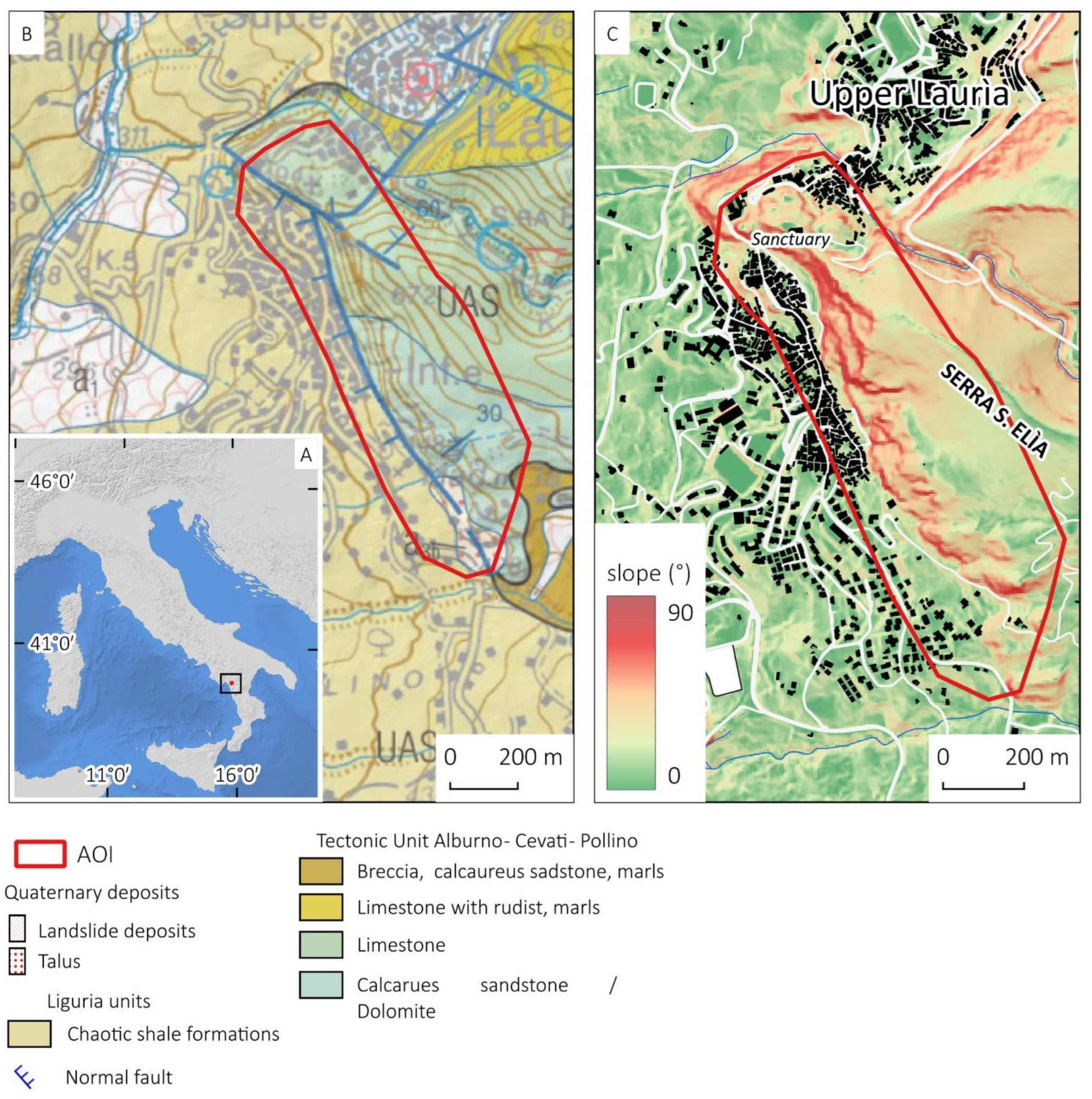
2. Study Area

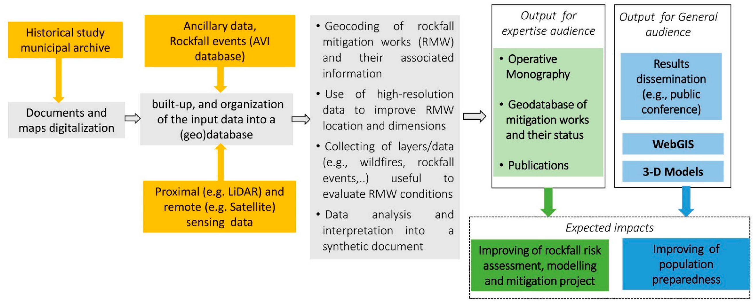
3. Materials and Methods
4. Results
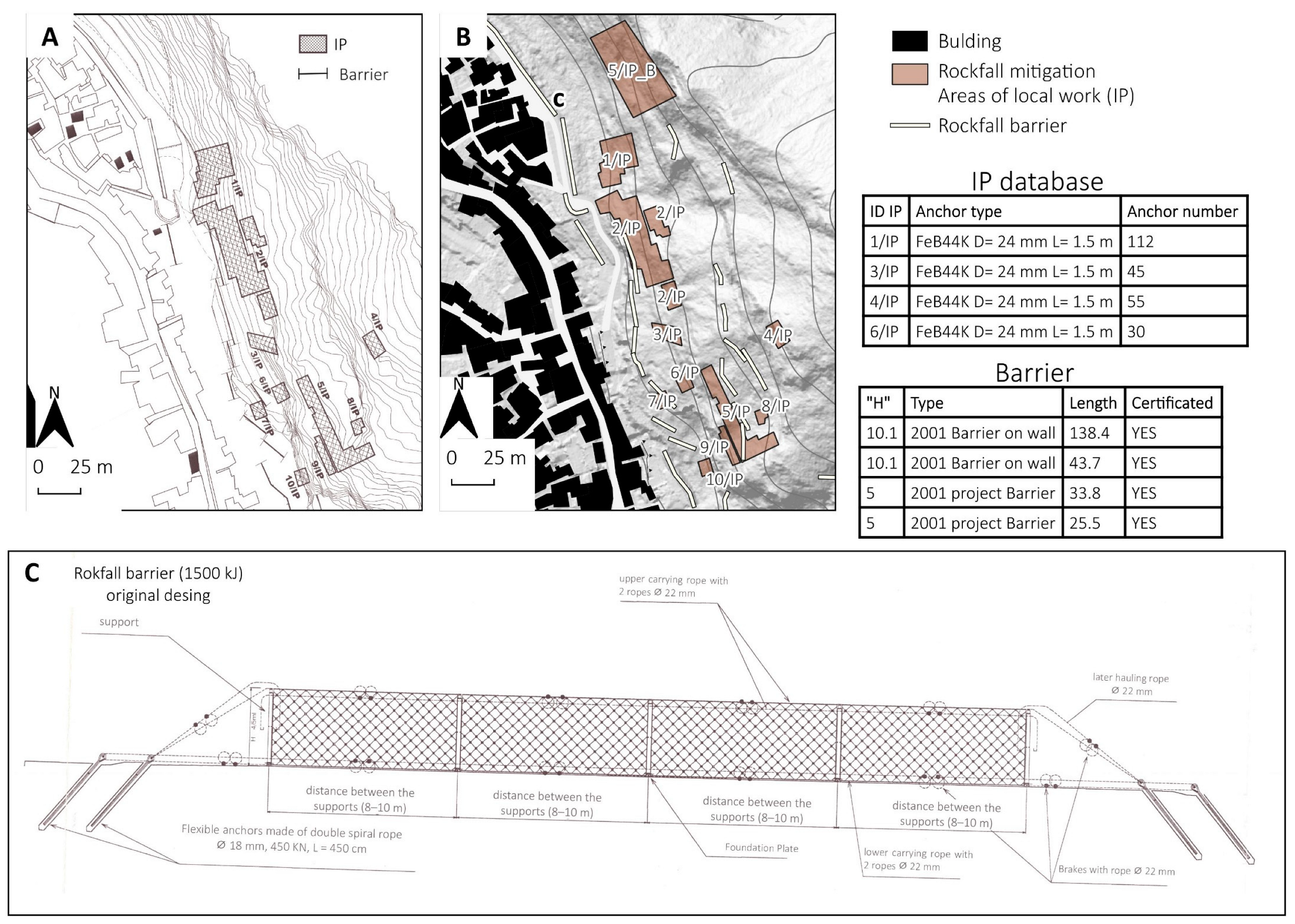
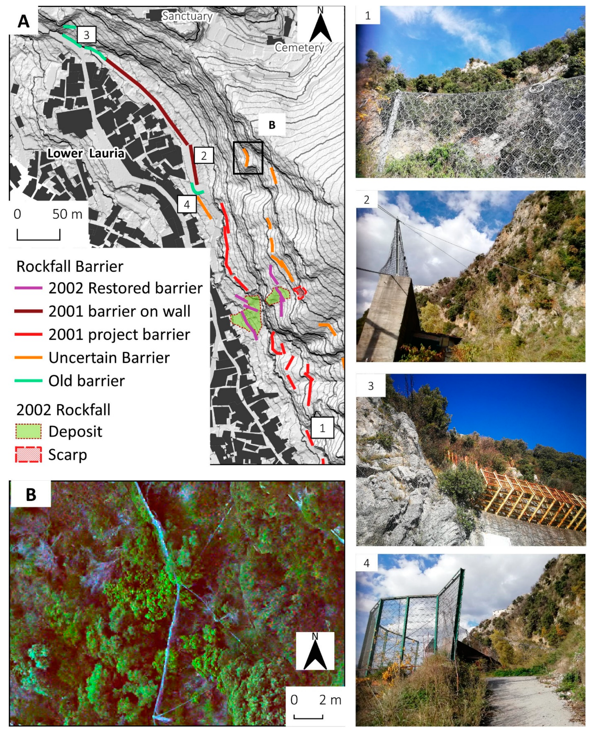
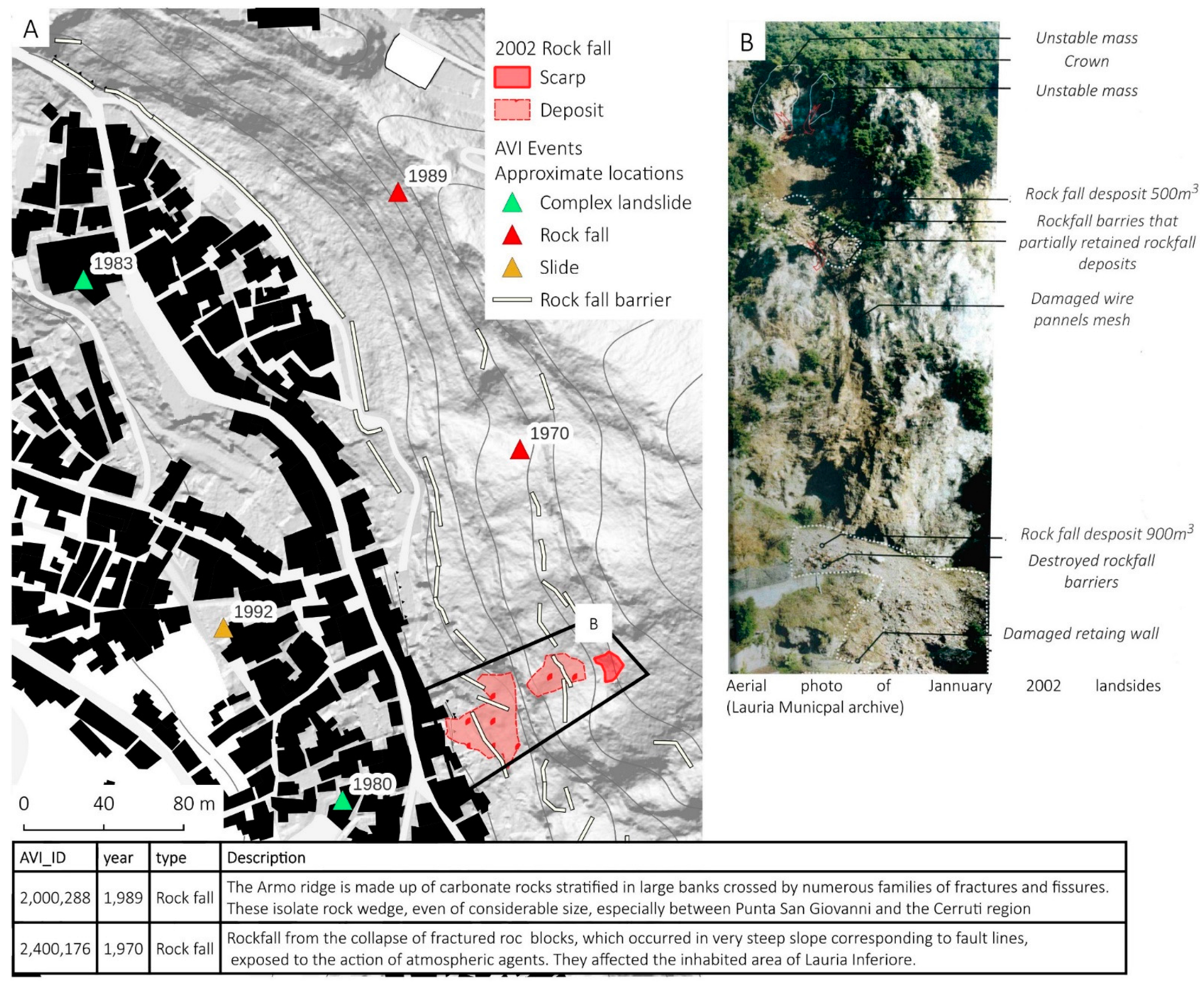
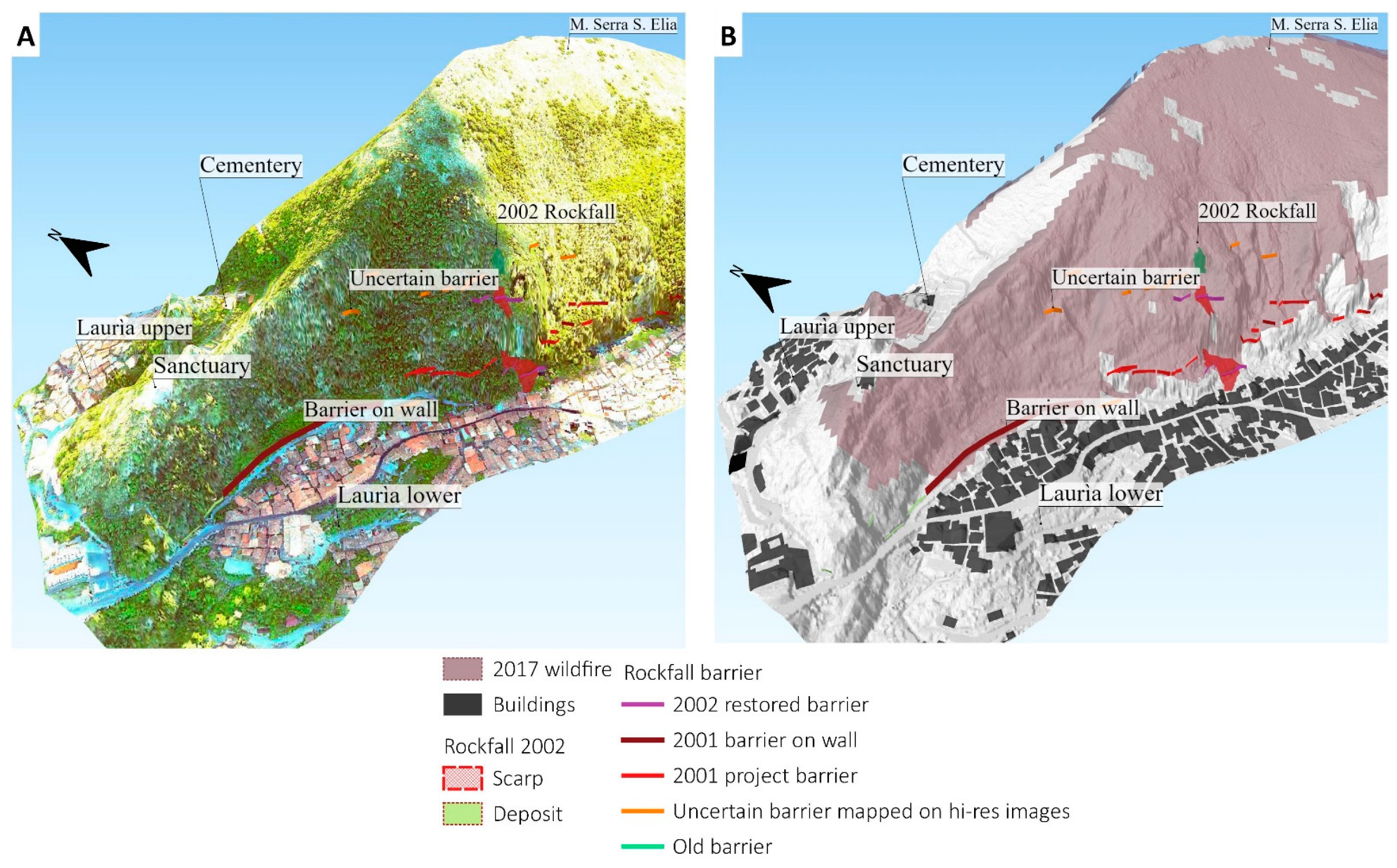
4.1. Archive Digitization and History of Rockfall Works and Events
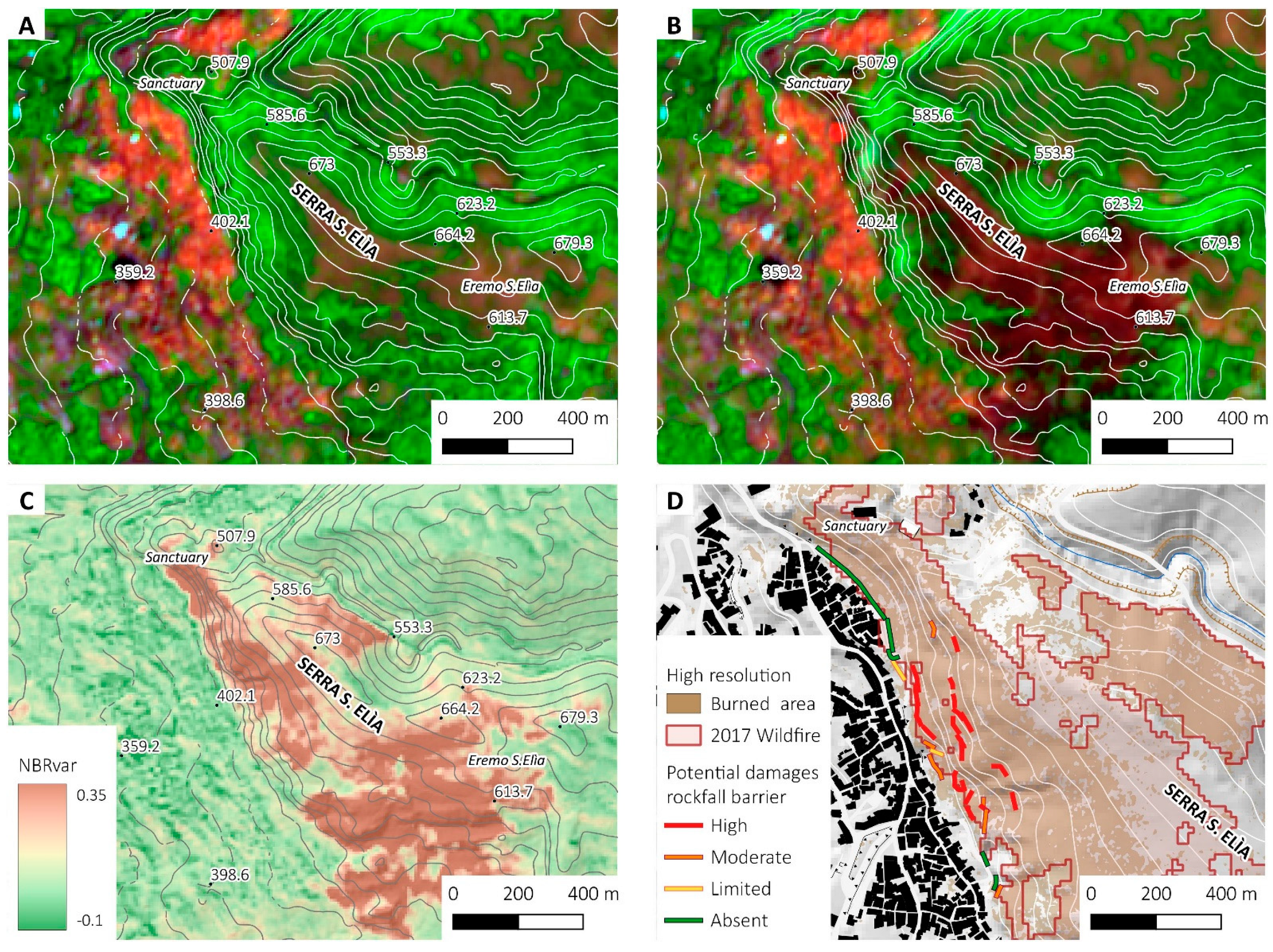
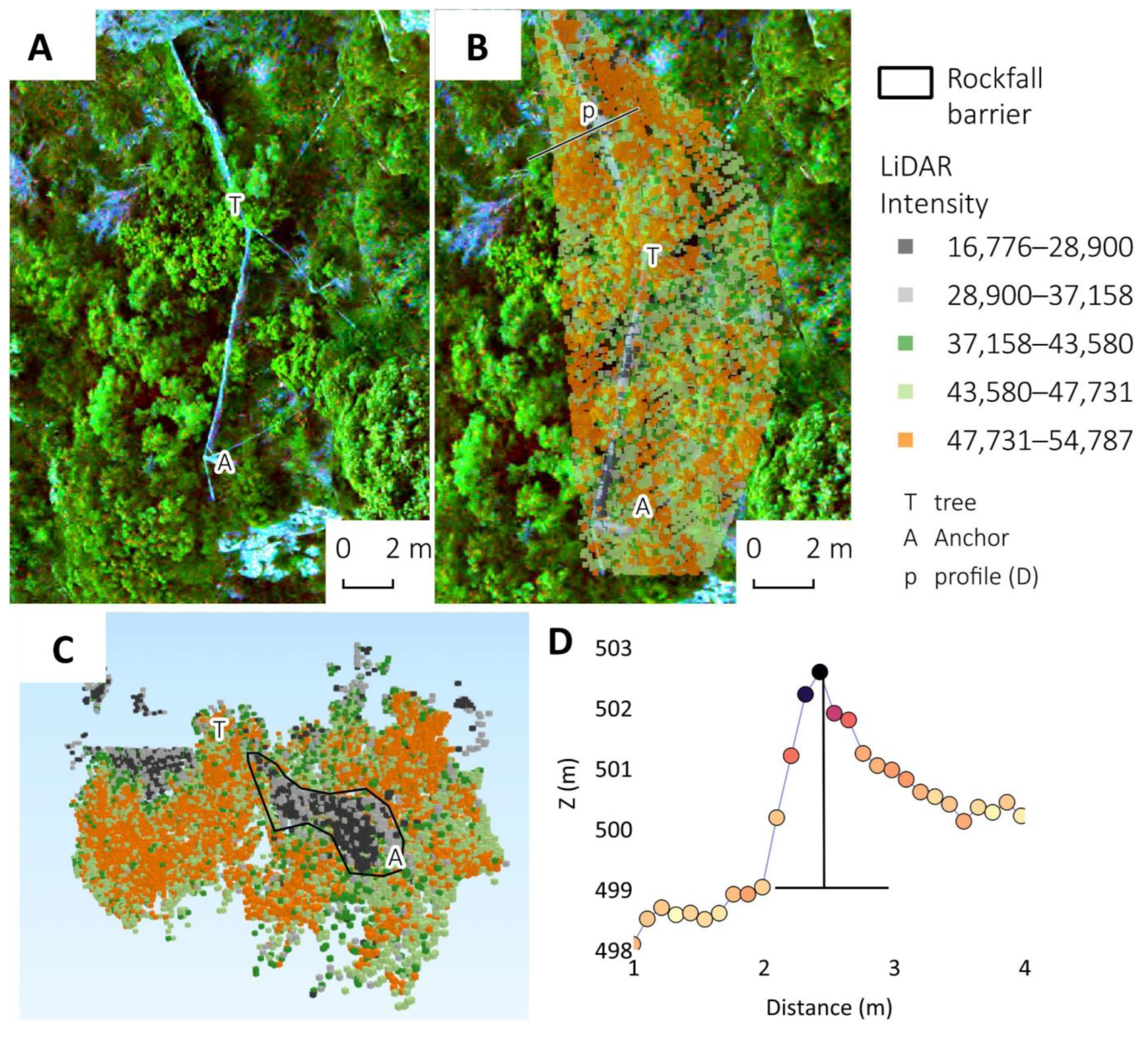
4.2. Remote Sensing and LiDAR
4.3. Operative Monograph and Results Dissemination
- the lack of data about the maintenance of rockfall works in the past few decades;
- the difficulty of collecting old certifications of the works;
- the need to update rock mass characterization and numerical modelling;
- the importance of constantly updating the digital database of mitigation and geocoding;
- the importance of planning rockfall mitigation strategies over a large scale (e.g., coordination with regional authorities) to optimise resources;
- the need for dissemination materials for the population of Lauria hamlet, in collaboration with an expert that worked on planning.
5. Discussion
6. Conclusions
Supplementary Materials
Author Contributions
Funding
Data Availability Statement
Acknowledgments
Conflicts of Interest
References
- Scavia, C.; Barbero, M.; Castelli, M.; Marchelli, M.; Peila, D.; Torsello, G.; Vallero, G. Evaluating Rockfall Risk: Some Critical Aspects. Geosciences 2020, 10, 98. [Google Scholar] [CrossRef] [Green Version]
- Depountis, N.; Nikolakopoulos, K.; Kavoura, K.; Sabatakakis, N. Description of a GIS-Based Rockfall Hazard Assessment Methodology and Its Application in Mountainous Sites. Bull. Eng. Geol. Environ. 2020, 79, 645–658. [Google Scholar] [CrossRef]
- Cignetti, M.; Godone, D.; Bertolo, D.; Paganone, M.; Thuegaz, P.; Giordan, D. Rockfall Susceptibility along the Regional Road Network of Aosta Valley Region (Northwestern Italy). J. Maps 2021, 17, 54–64. [Google Scholar] [CrossRef]
- Agliardi, F.; Crosta, G.B.; Frattini, P. Integrating Rockfall Risk Assessment and Countermeasure Design by 3D Modelling Techniques. Nat. Hazards Earth Syst. Sci. 2009, 9, 1059–1073. [Google Scholar] [CrossRef] [Green Version]
- Sarro, R.; Pérez-Rey, I.; Tomás, R.; Alejano, L.R.; Hernández-Gutiérrez, L.E.; Mateos, R.M. Effects of Wildfire on Rockfall Occurrence: A Review through Actual Cases in Spain. Appl. Sci. 2021, 11, 2545. [Google Scholar] [CrossRef]
- Toe, D.; Mentani, A.; Govoni, L.; Bourrier, F.; Gottardi, G.; Lambert, S. Introducing Meta-Models for a More Efficient Hazard Mitigation Strategy with Rockfall Protection Barriers. Rock Mech. Rock Eng. 2018, 51, 1097–1109. [Google Scholar] [CrossRef] [Green Version]
- Galve, J.P.; Cevasco, A.; Brandolini, P.; Piacentini, D.; Azañón, J.M.; Notti, D.; Soldati, M. Cost-Based Analysis of Mitigation Measures for Shallow-Landslide Risk Reduction Strategies. Eng. Geol. 2016, 213, 142–157. [Google Scholar] [CrossRef]
- Strada, C.; Tagnin, S.; Mottironi, M.; Larcher, V.; Villa, G.; Mair, V. Management of Rock Fall Risk on the Main Roads of Southtirol. In Engineering Geology for Society and Territory-Volume 2; Springer: Berlin/Heidelberg, Germany, 2015; pp. 1829–1833. [Google Scholar]
- Marchelli, M.; De Biagi, V.; Peila, D. A Quick-Assessment Procedure to Evaluate the Degree of Conservation of Rockfall Drapery Meshes. Frat. Ed Integrità Strutt. 2019, 13, 437–450. [Google Scholar] [CrossRef] [Green Version]
- de Graff, J.V.; Gallegos, A.J. The Challenge of Improving Identification of Rockfall Hazard after Wildfires. Environ. Eng. Geosci. 2012, 18, 389–397. [Google Scholar] [CrossRef]
- De Graff, J.V.; Shelmerdine, B.; Gallegos, A.; Annis, D. Uncertainty Associated with Evaluating Rockfall Hazard to Roads in Burned Areas. Environ. Eng. Geosci. 2015, 21, 21–33. [Google Scholar] [CrossRef]
- Melzner, S.; Shtober-Zisu, N.; Katz, O.; Wittenberg, L. Brief Communication: Post-Wildfire Rockfall Risk in the Eastern Alps. Nat. Hazards Earth Syst. Sci. 2019, 19, 2879–2885. [Google Scholar] [CrossRef] [Green Version]
- Turconi, L.; Tropeano, D.; Savio, G.; Bono, B.; De, S.K.; Frasca, M.; Luino, F. Torrential Hazard Prevention in Alpine Small Basin through Historical, Empirical and Geomorphological Cross Analysis in NW Italy. Land 2022, 11, 699. [Google Scholar] [CrossRef]
- Taylor, F.E.; Malamud, B.D.; Freeborough, K.; Demeritt, D. Enriching Great Britain’s National Landslide Database by Searching Newspaper Archives. Geomorphology 2015, 249, 52–68. [Google Scholar] [CrossRef] [Green Version]
- Guzzetti, F.; Cardinali, M.; Reichenbach, P. The AVI Project: A Bibliographical and Archive Inventory of Landslides and Floods in Italy. Environ. Manag. 1994, 18, 623–633. [Google Scholar] [CrossRef]
- Giordan, D.; Cignetti, M.; Wrzesniak, A.; Allasia, P.; Bertolo, D. Operative Monographies: Development of a New Tool for the Effective Management of Landslide Risks. Geosciences 2018, 8, 485. [Google Scholar] [CrossRef] [Green Version]
- Robiati, C.; Eyre, M.; Vanneschi, C.; Francioni, M.; Venn, A.; Coggan, J. Application of Remote Sensing Data for Evaluation of Rockfall Potential within a Quarry Slope. ISPRS Int. J. Geo-Inf. 2019, 8, 367. [Google Scholar] [CrossRef] [Green Version]
- Sarro, R.; Riquelme, A.; García-Davalillo, J.C.; Mateos, R.M.; Tomás, R.; Pastor, J.L.; Cano, M.; Herrera, G. Rockfall Simulation Based on UAV Photogrammetry Data Obtained during an Emergency Declaration: Application at a Cultural Heritage Site. Remote Sens. 2018, 10, 1923. [Google Scholar] [CrossRef] [Green Version]
- Santangelo, M.; Alvioli, M.; Baldo, M.; Cardinali, M.; Giordan, D.; Guzzetti, F.; Marchesini, I.; Reichenbach, P. Brief Communication: Remotely Piloted Aircraft Systems for Rapid Emergency Response: Road Exposure to Rockfall in Villanova Di Accumoli (Central Italy). Nat. Hazards Earth Syst. Sci. 2019, 19, 325–335. [Google Scholar] [CrossRef] [Green Version]
- Giordan, D.; Adams, M.S.; Aicardi, I.; Alicandro, M.; Allasia, P.; Baldo, M.; De Berardinis, P.; Dominici, D.; Godone, D.; Hobbs, P. The Use of Unmanned Aerial Vehicles (UAVs) for Engineering Geology Applications. Bull. Eng. Geol. Environ. 2020, 79, 3437–3481. [Google Scholar] [CrossRef] [Green Version]
- Menegoni, N.; Giordan, D.; Perotti, C.; Tannant, D.D. Detection and Geometric Characterization of Rock Mass Discontinuities Using a 3D High-Resolution Digital Outcrop Model Generated from RPAS Imagery–Ormea Rock Slope, Italy. Eng. Geol. 2019, 252, 145–163. [Google Scholar] [CrossRef]
- Castelli, M.; Torsello, G.; Vallero, G. Preliminary Modeling of Rockfall Runout: Definition of the Input Parameters for the QGIS Plugin QPROTO. Geosciences 2021, 11, 88. [Google Scholar] [CrossRef]
- Michetti, A.M.; Ferreli, L.; Esposito, E.; Porfido, S.; Blumetti, A.M.; Vittori, E.; Serva, L.; Roberts, G.P. Ground Effects during the 9 September 1998, Mw = 5.6 Lauria Earthquake and the Seismic Potential of the “Aseismic” Pollino Region in Southern Italy. Seismol. Res. Lett. 2000, 71, 31–46. [Google Scholar] [CrossRef]
- Canora, F.; Rizzo, G.; Panariello, S.; Sdao, F. Hydrogeology and Hydrogeochemistry of the Lauria Mountains Northern Sector Groundwater Resources (Basilicata, Italy). Geofluids 2019, 2019, 7039165. [Google Scholar] [CrossRef]
- Bonardi, G.; Cinque, A.; De Capoa, P.; Di Staso, P.; Esposito, P.; Giuda, D.; Mazzoli, S.; Parente, M.; Radoičić, R.; Sgrosso, A.; et al. Note Illustrative della Carta Geologica D’italia Alla Scala 1:50.000—Goglio 521 Lauria; Dipartimento Difesa del Suolo, Servizio Geo: Abruzzo, Italy, 2016. [Google Scholar]
- Lasaponara, R.; Tucci, B.; Ghermandi, L. On the Use of Satellite Sentinel 2 Data for Automatic Mapping of Burnt Areas and Burn Severity. Sustainability 2018, 10, 3889. [Google Scholar] [CrossRef] [Green Version]
- RSDI—Geoportale della Basilicata RSDI—Geoportale della Basilicata 2015. Available online: https://rsdi.regione.basilicata.it/ (accessed on 28 October 2022).
- ISPRA IFFI—Inventario dei Fenomeni Franosi in Italia. Available online: https://www.progettoiffi.isprambiente.it/ (accessed on 28 October 2022).
- Ministero Transizione Ecologica—Italian Government Geoportale Nazionale. Available online: http://www.pcn.minambiente.it/mattm/ (accessed on 28 October 2022).
- Miller, J.D.; Thode, A.E. Quantifying Burn Severity in a Heterogeneous Landscape with a Relative Version of the Delta Normalized Burn Ratio (DNBR). Remote Sens. Environ. 2007, 109, 66–80. [Google Scholar] [CrossRef]
- Cocke, A.E.; Fulé, P.Z.; Crouse, J.E. Comparison of Burn Severity Assessments Using Differenced Normalized Burn Ratio and Ground Data. Int. J. Wildland Fire 2005, 14, 189–198. [Google Scholar] [CrossRef] [Green Version]
- Morresi, D.; Marzano, R.; Lingua, E.; Motta, R.; Garbarino, M. Mapping Burn Severity in the Western Italian Alps through Phenologically Coherent Reflectance Composites Derived from Sentinel-2 Imagery. Remote Sens. Environ. 2022, 269, 112800. [Google Scholar] [CrossRef]
- Lindsay, J.B. The Whitebox Geospatial Analysis Tools Project and Open-Access GIS. In Proceedings of the GIS Research UK 22nd Annual Conference, The University of Glasgow, Glasgow, UK, 16–18 April 2014; pp. 16–18. [Google Scholar]
- Open Source Geospatial Foundation GeoServer. Available online: https://geoserver.org/ (accessed on 7 September 2022).
- Cignetti, M.; Guenzi, D.; Ardizzone, F.; Allasia, P.; Giordan, D. An Open-Source Web Platform to Share Multisource, Multisensor Geospatial Data and Measurements of Ground Deformation in Mountain Areas. ISPRS Int. J. Geo-Inf. 2019, 9, 4. [Google Scholar] [CrossRef] [Green Version]
- Núñez-Andrés, M.A.; Lantada Zarzosa, N.; Martínez-Llario, J. Spatial Data Infrastructure (SDI) for Inventory Rockfalls with Fragmentation Information. Nat. Hazards 2022, 112, 2649–2672. [Google Scholar] [CrossRef]
- GeoSolutions MapStore. Available online: https://www.geosolutionsgroup.com/technologies/mapstore/ (accessed on 7 September 2022).
- Minoru, A. Qgis2threejs Plugin Document—Qgis2threejs Plugin 2.4 Documentation. Available online: https://qgis2threejs.readthedocs.io/en/docs/ (accessed on 22 July 2020).
- Guadagno, M. Landslide inventory record N. 2400176. SICI—Sistema Informativo Catastrofi Idrogeologiche (Information System for Hydrogeological Disasters). Istituto di Ricerca per la Protezione Idrogeologica (IRPI) del Consiglio Nazionale delle Ricerche e Gruppo Nazionale per la Difesa dalle Catastrofi Idrogeologiche (GNDCI) del Consiglio Nazionale delle Ricerche. Available online: http://wwwdb.gndci.cnr.it/php2/avi/frane_tutto.php?numero_frana=2400176&lingua=en (accessed on 14 September 2022).
- Guadagno, M. Landslide Inventory Record N. 2000288. SICI—Sistema Informativo Catastrofi Idrogeologiche Idrogeologiche (Information System for Hydrogeological Disasters)—Istituto di Ricerca per la Protezione Idrogeologica (IRPI) del Consiglio Nazionale delle Ricerche e Gruppo Nazionale per la Difesa dalle Catastrofi Idrogeologiche (GNDCI) del Consiglio Nazionale delle Ricerche. Available online: http://wwwdb.gndci.cnr.it/php2/avi/frane_tutto.php?numero_frana=2000288&lingua=en (accessed on 14 September 2022).
- Pitella, G. Interrogazione A Risposta Scritta 4/05725 Presentata da Pittella Giovanni Saverio in Data 1996-11-28—(Parliamentary Question 4/05725 Submitted by Pittella Giovanni Saverio on 28 November 1996). Available online: http://dati.camera.it/ocd/aic.rdf/aic4_05725_13 (accessed on 13 July 2022).
- Lauria Town Hall. Progetto dell’intervento definitivo per il consolidamento della parete rocciosa dell’Armo. Capitolato d’appalto. Ministero dell’Interno—Coordinamento della Protezione Civile ORDINANZA N.2632/97 (Final design for the consolidation of Armo rockfall prone slope. Tender specifications. Ministry of the Interior—Civil Protection ORDER N.2632/97). Reserved unpublished report (Italian). 1997. [Google Scholar]
- Lauria Town hall. Lavori di somma urgenza volti a fronteggiare l’aggravamento del dissesto idrogeologico della parete rocciosa dell’armo, a seguito del sisma del 09/09/98. Relazione sui lavori della 2/a fase di Somma Urgenza—Ispezioni e rilievo geostrutturale in parete (Highly urgent works aimed at mitigating the worsening of the instability of the Armo slope, following the earthquake of 09/09/98. Geostructural survey report). Reserved unpublished report (Italian). 1998.
- Lauria Town Hall. Intervento definitivo per il consolidamento della parete rocciosa dell’Armo (Final project for the consolidation of the Armo cliff). Comune di Lauria, Provincia di Potenza. Reserved unpublished report (Italian). 2001. [Google Scholar]
- Lauria Town Hall. Relazione sulle ispezioni ed i rilievi in parete condotti lungo il tratto di versante del costone roccioso “Armo” interessato dai fenomeni di crollo del 23.01.02 e proposte per il successivo risanamento e per la sistemazione delle aree ad esso sottostanti (Report the filed surveys conducted along the slope affected by the 23 jannuary 2002 rockfall on Costone dell’Armo ridge and proposals for the subsequent rehabilitation and restoring of the damaged works). Reserved unpublished report (Italian). 2002. [Google Scholar]
- Lauria Town Hall. Progetto esecutivo per il ripristino imposto dalla frana sul Costone Armo del 23 gennaio 2002 (executive project for the resotorinf of mimitgation works damage by 2002 rockfall). Città di Lauria Provincia di Potenza Settore Assetto ed Uso del Territorio Servizio Lavori Pubblici. Reserved unpublished report (Italian). 2002. [Google Scholar]
- Infopinione. Lauria, Abitazioni Minacciate da Incendio: Le Immagini (Lauria, Houses Threatened by Fire: The Images). 2017. Available online: https://www.infopinione.it/index.php/2017/07/11/lauria-abitazioni-minacciate-incendio-le-immagini/ (accessed on 14 September 2022). (In Italian).
- Giordan, D.; Notti, D.; Guenzi, D. Analisi e webGIS delle opere di difesa Costone dell’Armo Lauria (PZ). [43]Analyss and webGSI of rockfall mitigation work of Armo ridge (Lauria, PZ). Operative Monography commissioned by Lauria Municipality, CNR-IRPI. Reserved unpublished report (Italian). 2020. [Google Scholar]
- Lauria Town Hall. Lavori di Ripristino della Funzionalità e Sicurezza delle Reti Paramassi sul Costone Armo Sovrastante L’abitato di Lauria (Works to Restore the Efficiency of the Rockfall Nets on the Armo Ridge Upstream of the Town of Lauria). 2021. Available online: https://www.comune.lauria.pz.it/wp-content/uploads/2021/10/AVVISO-ESITI-DI-GARA.pdf (accessed on 13 September 2022). (In Italian).
- Notti, D.; Guenzi, D. 3-D View of a Slope Affected by Rockfall. 2022. Available online: https://zenodo.org/record/6875771 (accessed on 13 September 2022).
- Vagnon, F.; Bonetto, S.; Ferrero, A.M.; Harrison, J.P.; Umili, G. Eurocode 7 and Rock Engineering Design: The Case of Rockfall Protection Barriers. Geosciences 2020, 10, 305. [Google Scholar] [CrossRef]
- Laura, G.; Strada, C. The Role of Rockfall Protection Barriers in the Context of Risk Mitigation: The Case of the Autonomous Province of Bolzano. In Engineering Geology for Society and Territory—Volume 5; Springer: Berlin/Heidelberg, Germany, 2015; pp. 397–400. [Google Scholar]
- Bolzano Province Protection Structures-Rockfalls Works-Lines. Available online: https://geokatalog.buergernetz.bz.it/geokatalog/#!home&layer=p_bz%3AHazards%3AProtectionStructures-RockfallsWorks-Lines (accessed on 27 July 2022).
- Giordan, D.; Cignetti, M.; Godone, D.; Bertolo, D.; Paganone, M. Definition of an Operative Methodology for the Management of Rockfalls along with the Road Network. Sustainability 2021, 13, 7669. [Google Scholar] [CrossRef]
- Ortiz, R.; Castro, L.; Marambio, S. A Methodology for Semi-Quantitative Analysis of Rockfall Hazards and Cost-Benefit-Based Mitigation Design. In Rock Mechanics for Natural Resources and Infrastructure Development; CRC Press: Boca Raton, FL, USA, 2019; pp. 352–359. ISBN 0-367-82317-9. [Google Scholar]
- Tropeano, D.; Turconi, L. Using Historical Documents for Landslide, Debris Flow and Stream Flood Prevention. Applications in Northern Italy. Nat. Hazards 2004, 31, 663–679. [Google Scholar] [CrossRef]
- Napolitano, E.; Marchesini, I.; Salvati, P.; Donnini, M.; Bianchi, C.; Guzzetti, F. LAND-DeFeND–An Innovative Database Structure for Landslides and Floods and Their Consequences. J. Environ. Manag. 2018, 207, 203–218. [Google Scholar] [CrossRef] [PubMed]
- Petrucci, O.; Polemio, M. The Use of Historical Data for the Characterisation of Multiple Damaging Hydrogeological Events. Nat. Hazards Earth Syst. Sci. 2003, 3, 17–30. [Google Scholar] [CrossRef]


| Data/Documents Repository | Document Filename | Shorth Descriptions | Year | |
|---|---|---|---|---|
| Parent | Child | |||
| 01_1997_ Draft projects | 03_Normative | Tecnhichal_specifications.pdf | Rockfall mitigation works requirements | 1999 |
| Barrier_req.pdf | Rockfall barriers requirements | 1999 | ||
| 04_Maps | Widespread_instability_map.tif | Preliminary maps of widespread rockfall instability | 1999 | |
| Punctual_instability_map.tif | Preliminary maps of punctual rockfall instability | 1999 | ||
| 02_1998 | 01_geomechanicahl | Geomechanical_rel.pdf | Rock mass characterization relation and maps | 1998 |
| 03_Final projects | 03_Certificates | Rokfall_barrier_pr_1500kJ.tif | Rockfall barrier sketch | 2001 |
| Rokfall_barrier_cert_1500kJ.pdf | Rockfall barrier certificate | 2001 | ||
| 04_2002 Rockfall event | 02_Maps | 2002_barrier_maps.tif | Rockfall barriers maps | 2002 |
| 2002_restore_maps.tif | Maps of restoration of damaged mitigation works | 2002 | ||
| Events/Action | Date | Source |
|---|---|---|
| Rockfall (generic report) | 1970 | AVI project [39] |
| Rockfall (report on mitigation strategy) | 1983 | AVI project [40] |
| Rockfall event | 1996-11 | parliamentary question [41] |
| Rockfall mitigation study start | 1997 | Lauria archive [42] |
| Rockfall triggered by an earthquake | 1998-09 | Lauria archive [43] |
| Rockfall mitigation works ends | 2001 | Lauria archive [44] |
| Rockfall damaged some mitigation structures | 2002-01 | Lauria archive [45] |
| Restoration of damaged structures | 2002 | Lauria archive [46] |
| Rockfall triggered by fires | 2017 | Local newspaper [47] |
| State of the art of mitigation work | 2021 | OM and webGIS of CNR-IRPI [48] |
| Start of the restoration of mitigation structures | 2022 | Lauria municipality [49] |
| Dataset/Study | Current Status | Notes |
|---|---|---|
| Geomechanical study | P | Only a technical report aged 1998 is available, a new study with more precise geocoding is suggested. |
| DTM | V | The new HR LiDAR DTM cover all the affected slope. |
| Numerical modelling | X | Runout modelling based on HR DTM could help design the restoration of mitigation structures. |
| Maintenance status information | X | An in-situ analysis, made by experts, is necessary to evaluate the structural condition of existing mitigation work. |
| Rockfall event database | P | A more systematic inventory of rock fall events is necessary. |
| Geodatabase/webGIS | V | They need to be updated when new data are available. |
| Dissemination | P | Public engagement on rockfall risk is necessary |
Publisher’s Note: MDPI stays neutral with regard to jurisdictional claims in published maps and institutional affiliations. |
© 2022 by the authors. Licensee MDPI, Basel, Switzerland. This article is an open access article distributed under the terms and conditions of the Creative Commons Attribution (CC BY) license (https://creativecommons.org/licenses/by/4.0/).
Share and Cite
Notti, D.; Guenzi, D.; Lasaponara, R.; Giordan, D. Merging Historical Archives with Remote Sensing Data: A Methodology to Improve Rockfall Mitigation Strategy for Small Communities. Land 2022, 11, 1951. https://doi.org/10.3390/land11111951
Notti D, Guenzi D, Lasaponara R, Giordan D. Merging Historical Archives with Remote Sensing Data: A Methodology to Improve Rockfall Mitigation Strategy for Small Communities. Land. 2022; 11(11):1951. https://doi.org/10.3390/land11111951
Chicago/Turabian StyleNotti, Davide, Diego Guenzi, Rosa Lasaponara, and Daniele Giordan. 2022. "Merging Historical Archives with Remote Sensing Data: A Methodology to Improve Rockfall Mitigation Strategy for Small Communities" Land 11, no. 11: 1951. https://doi.org/10.3390/land11111951