

Landscapes of Mobility and Movement in North-West Arabia: A Remote Sensing Study of the Neom Impact Zone
Abstract
:1. Introduction
2. Materials and Methods
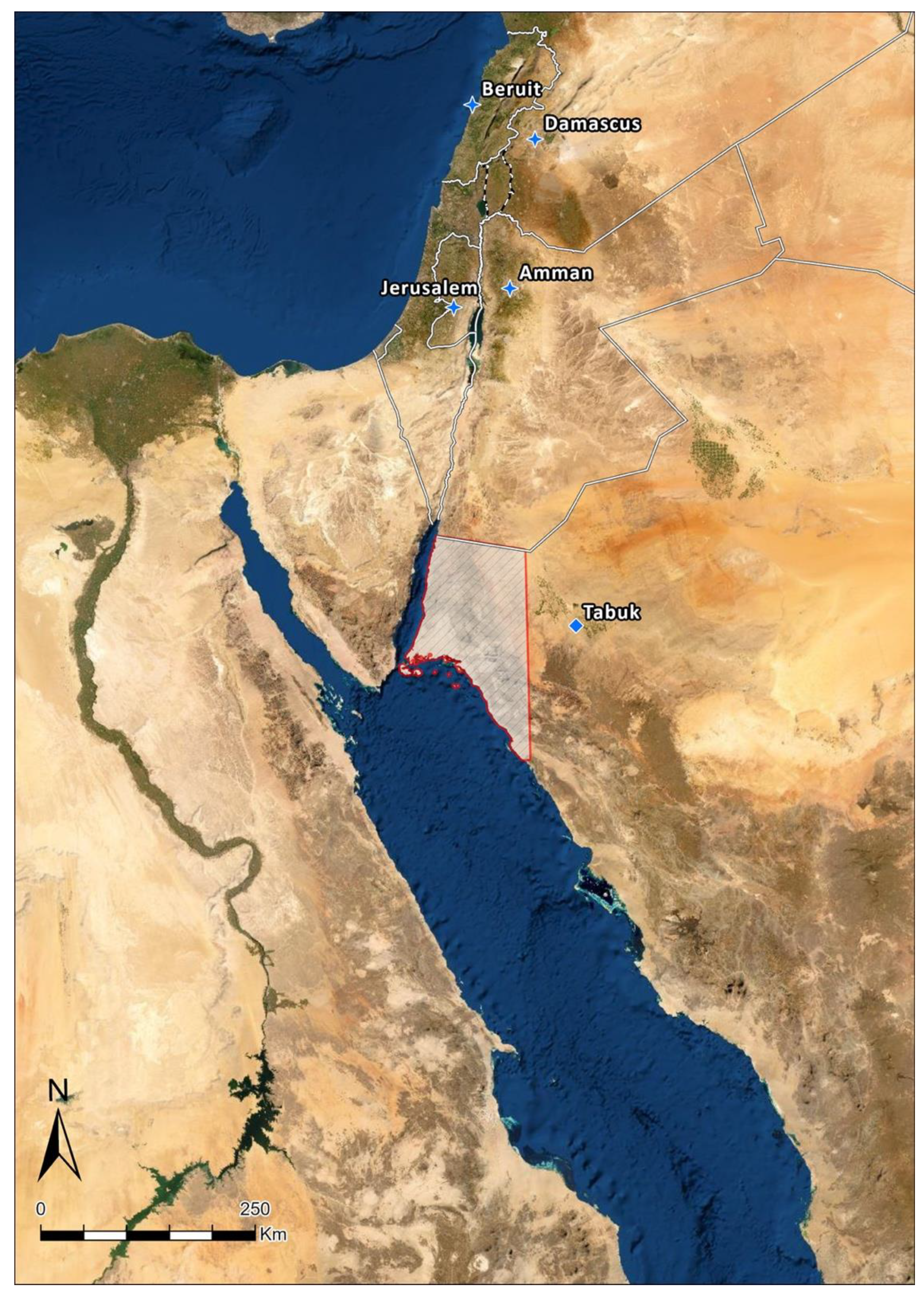
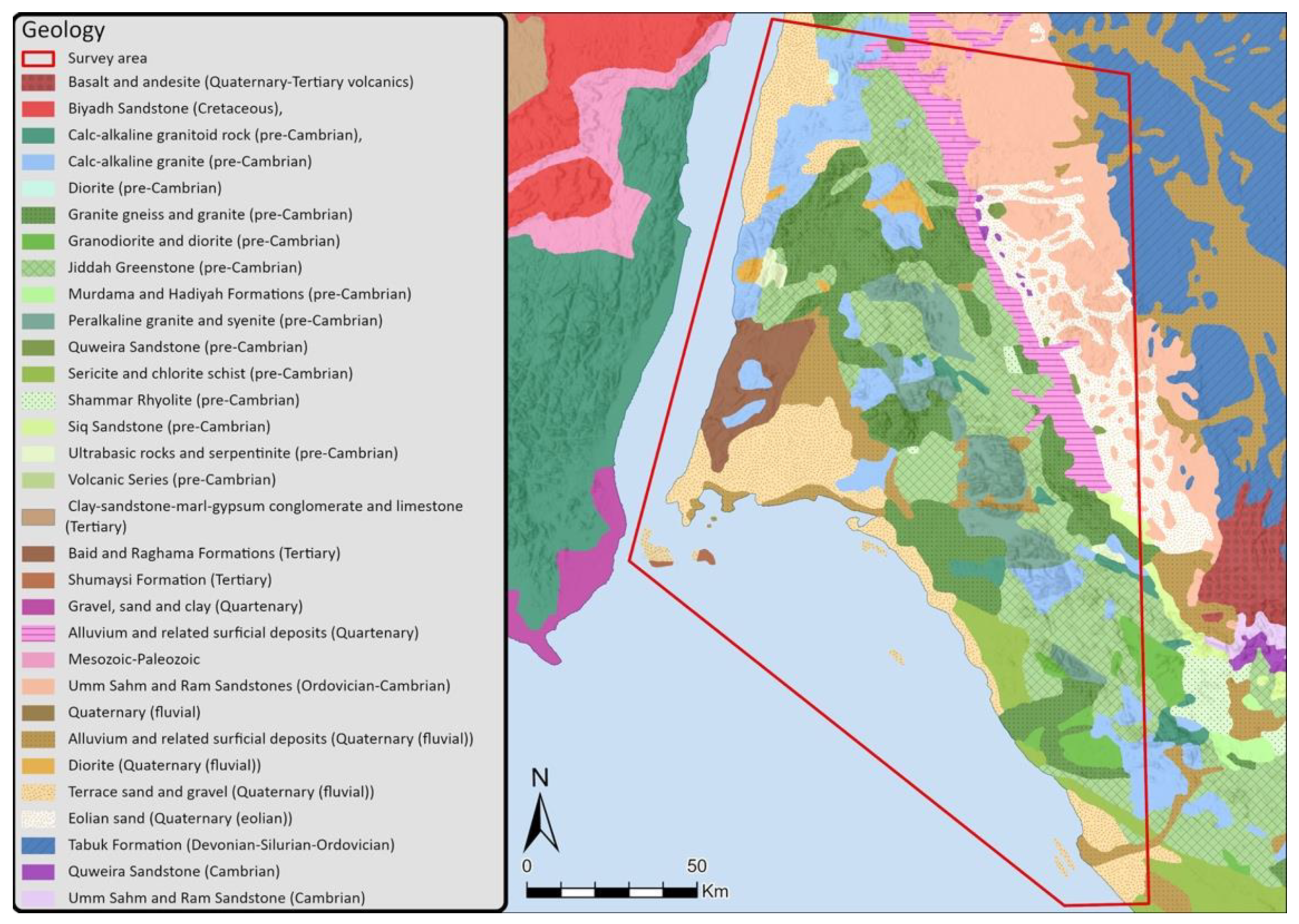
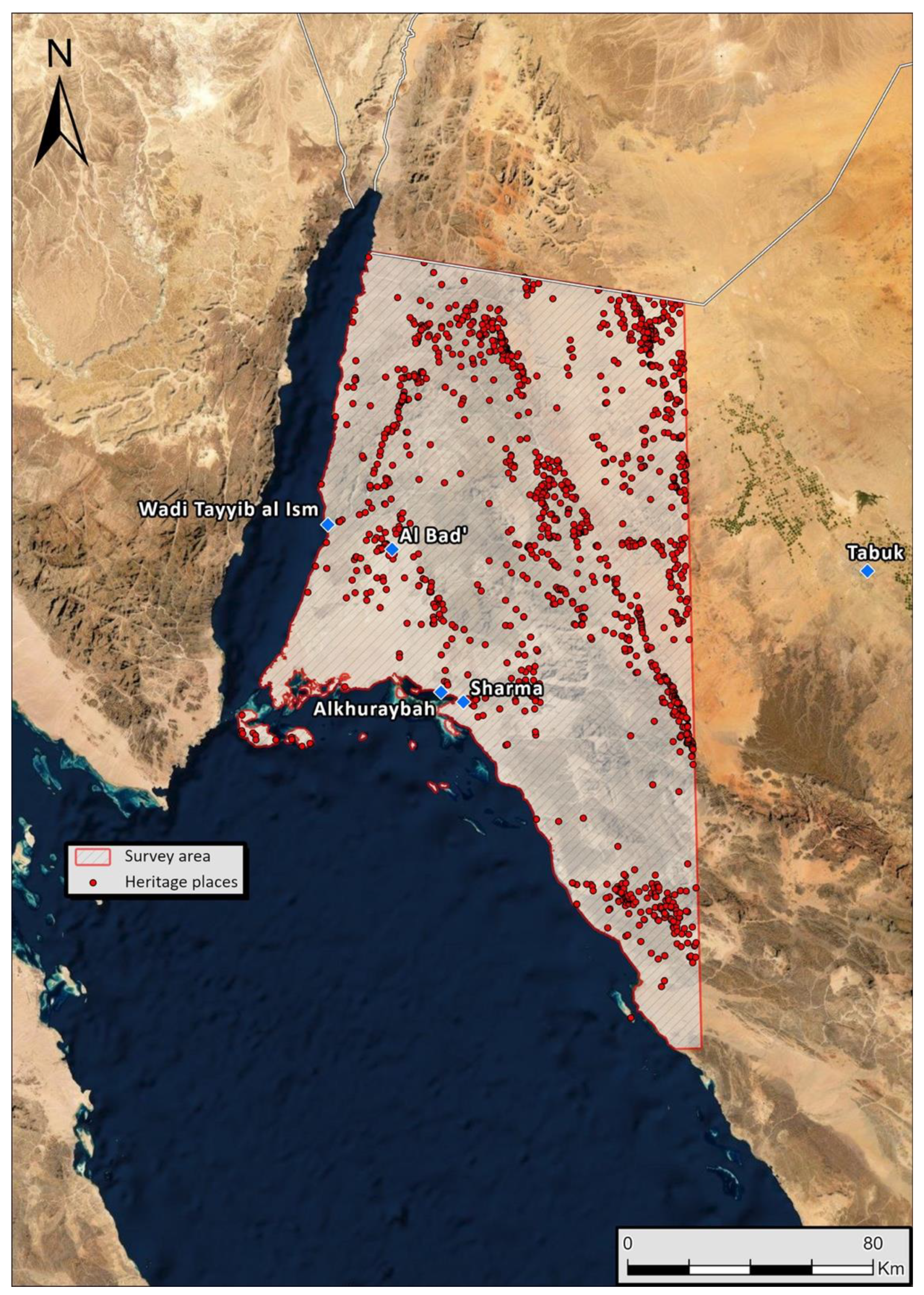
2.1. Background

2.2. Methodology
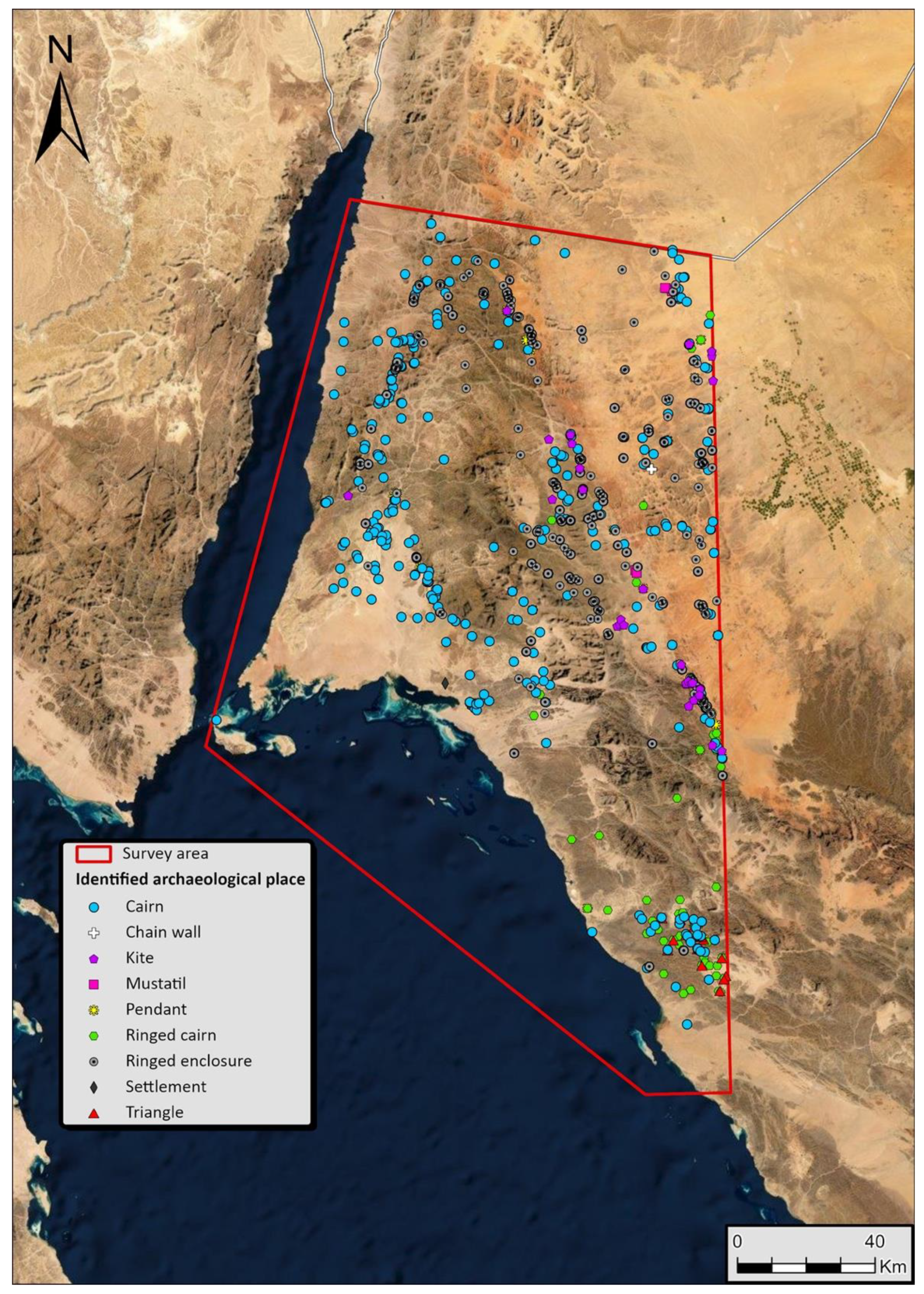
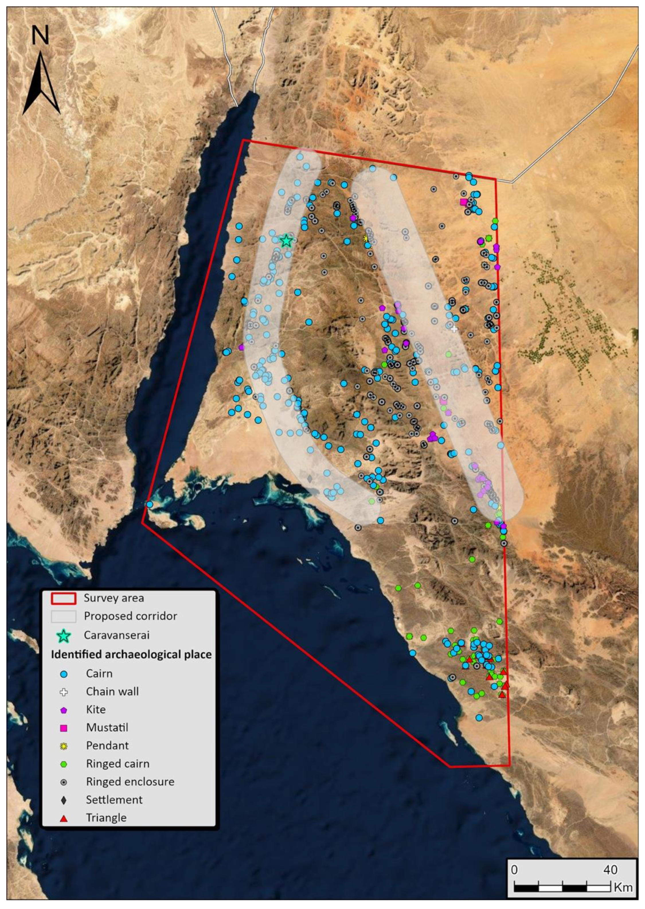
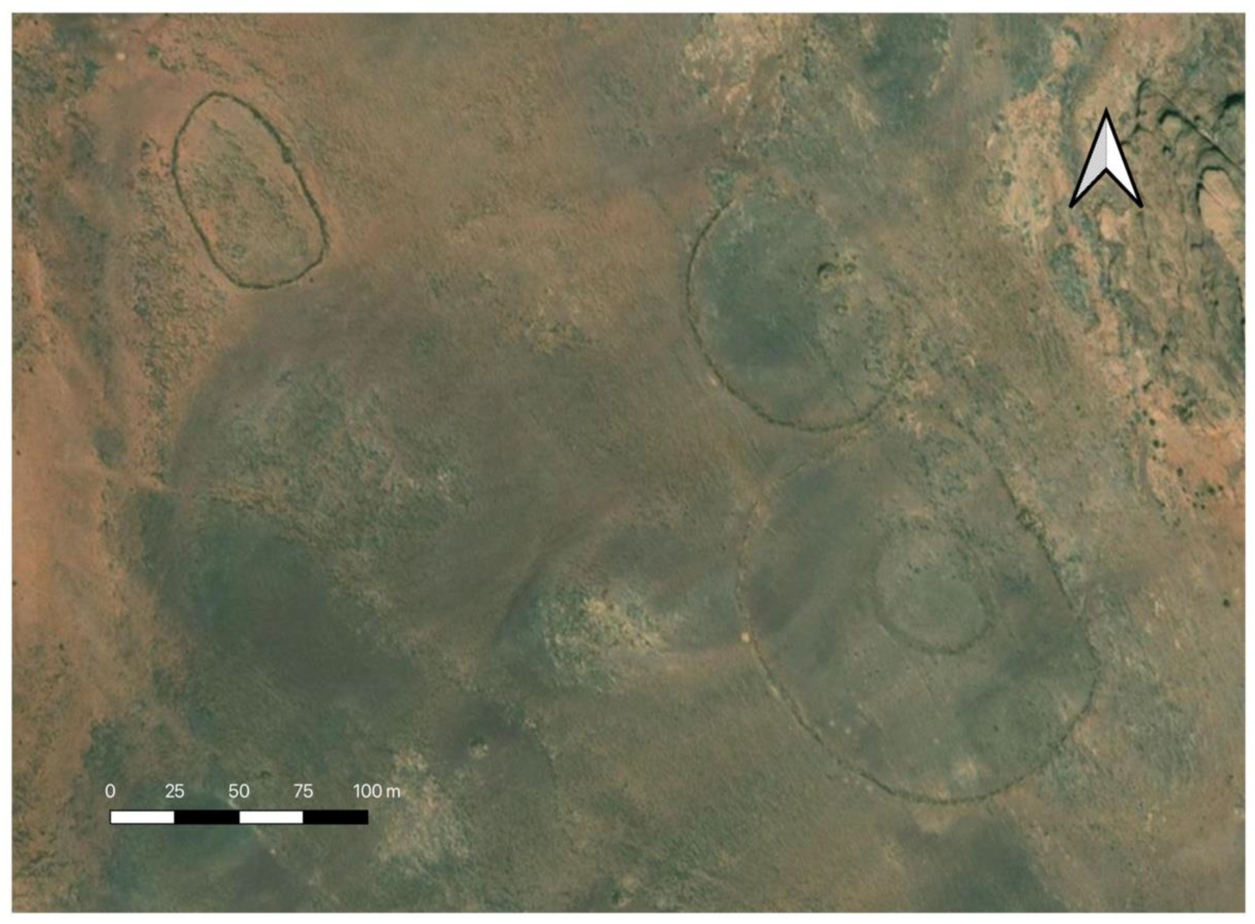
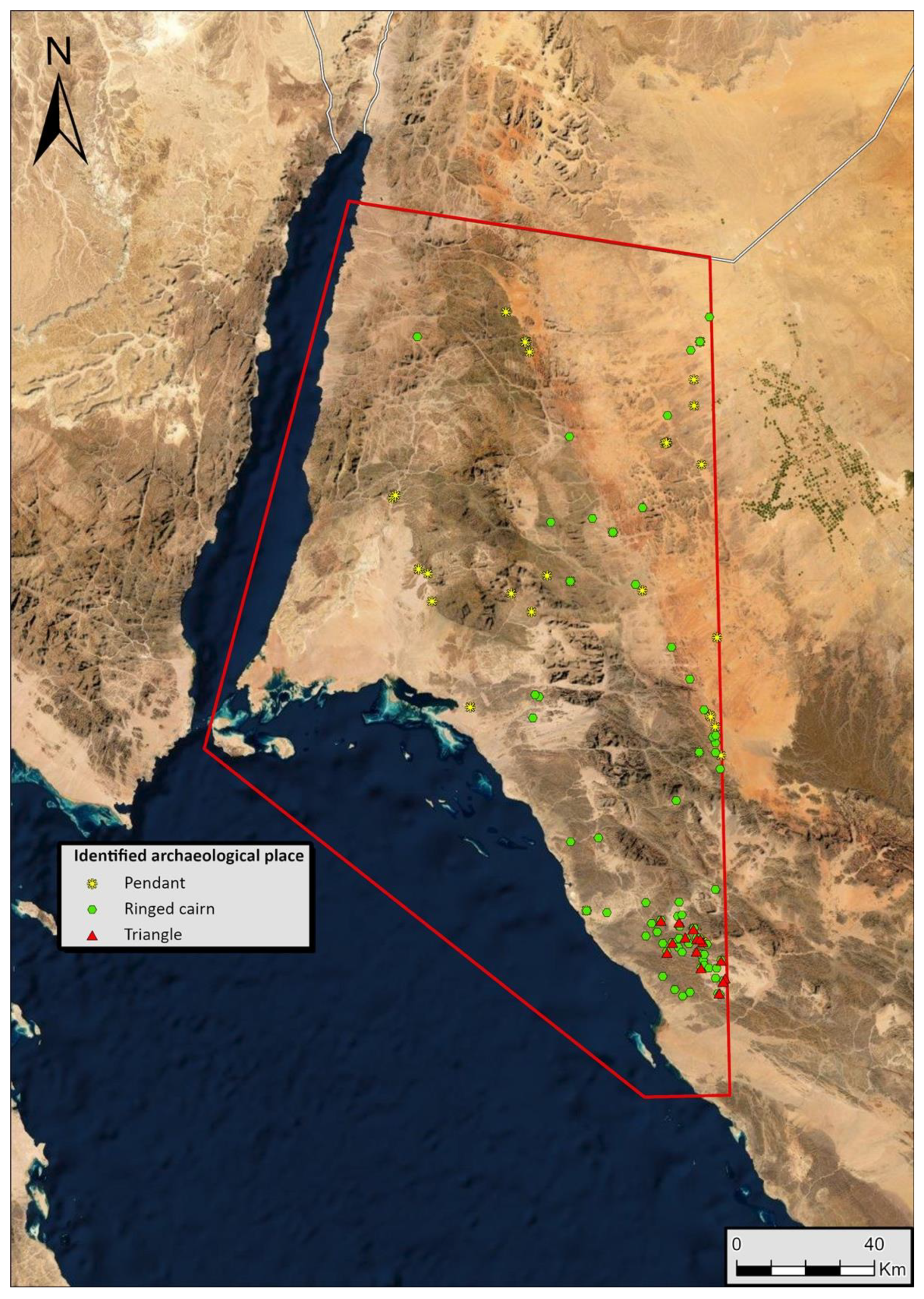
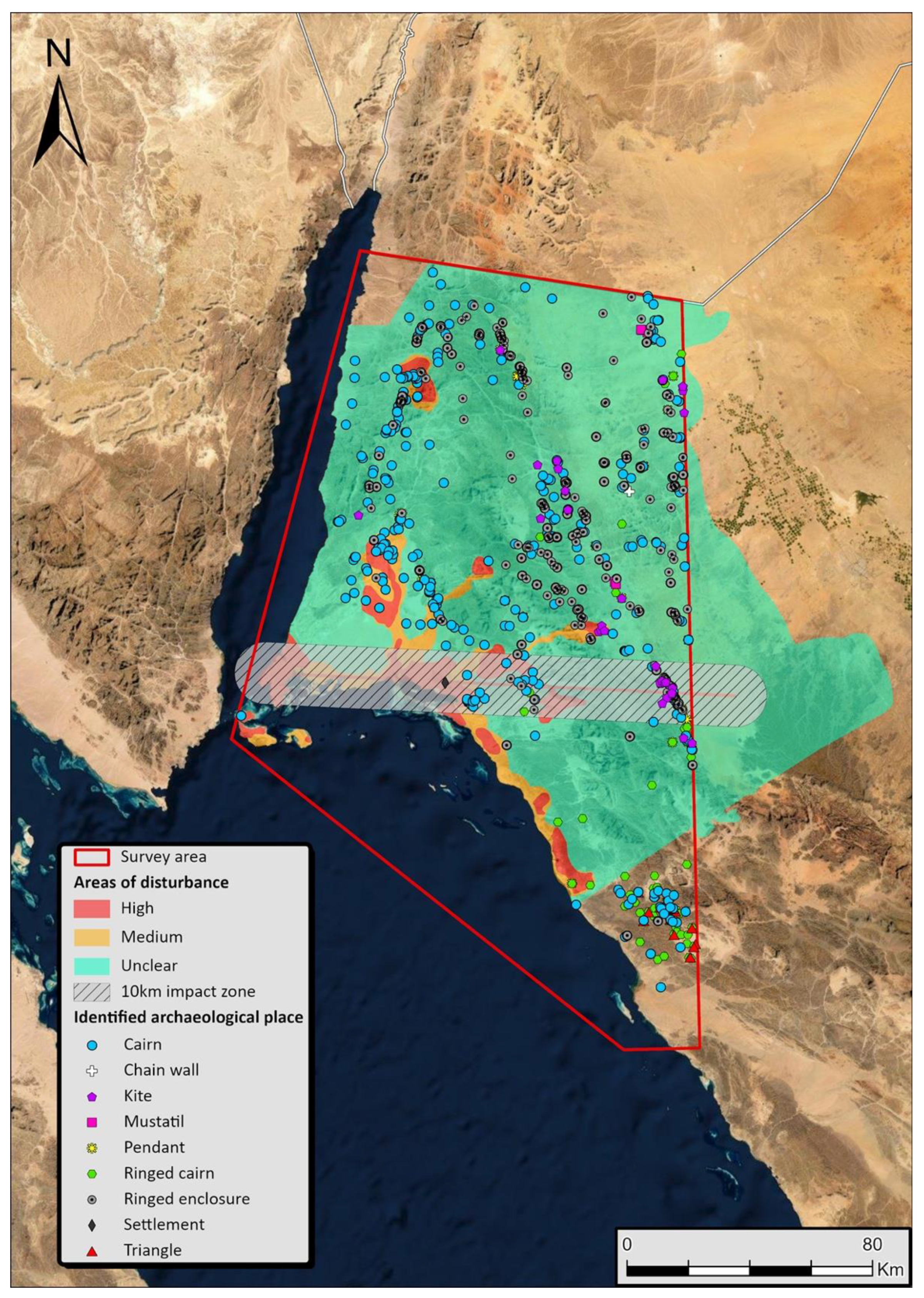
3. Results
4. Discussion
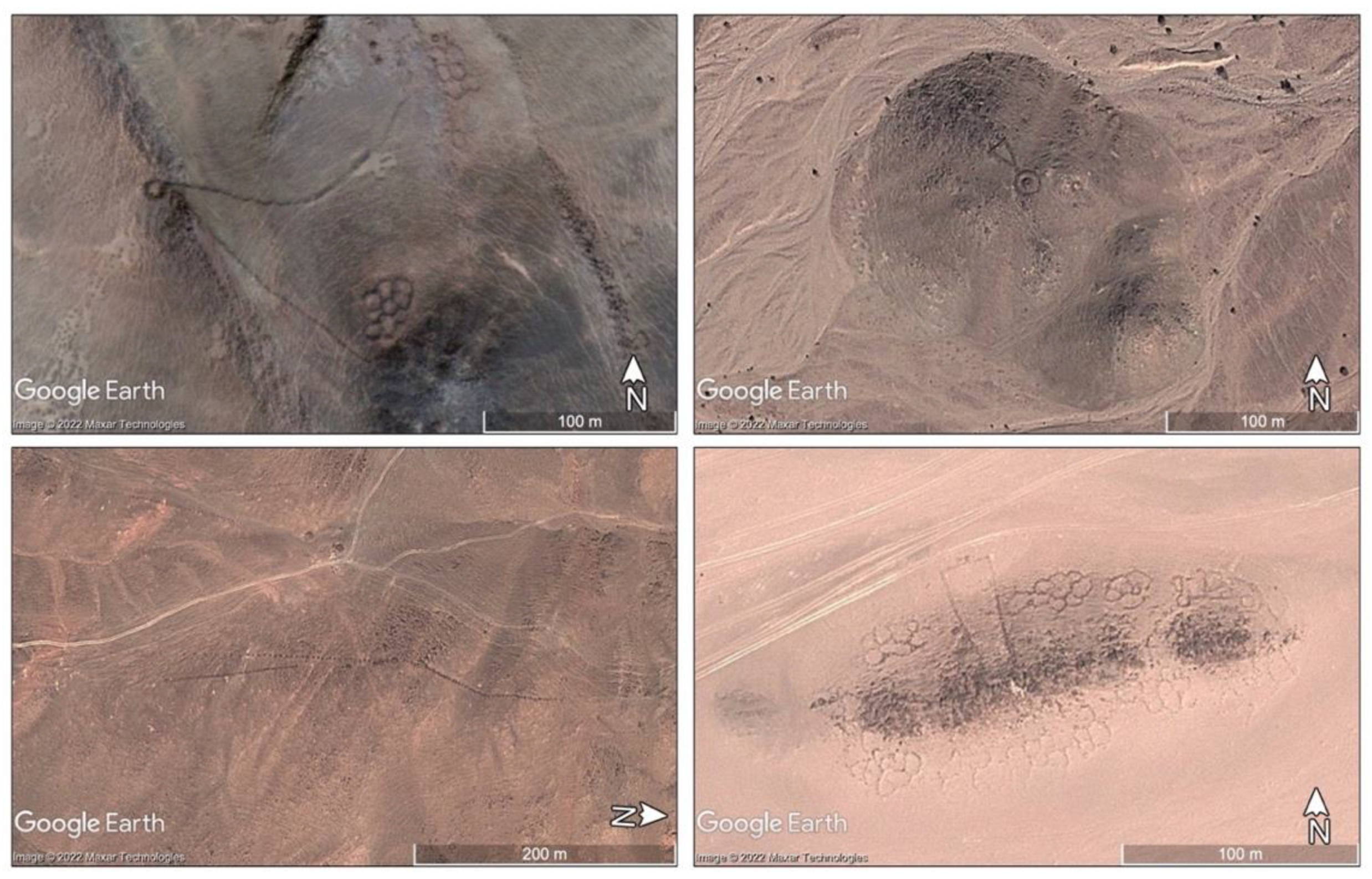
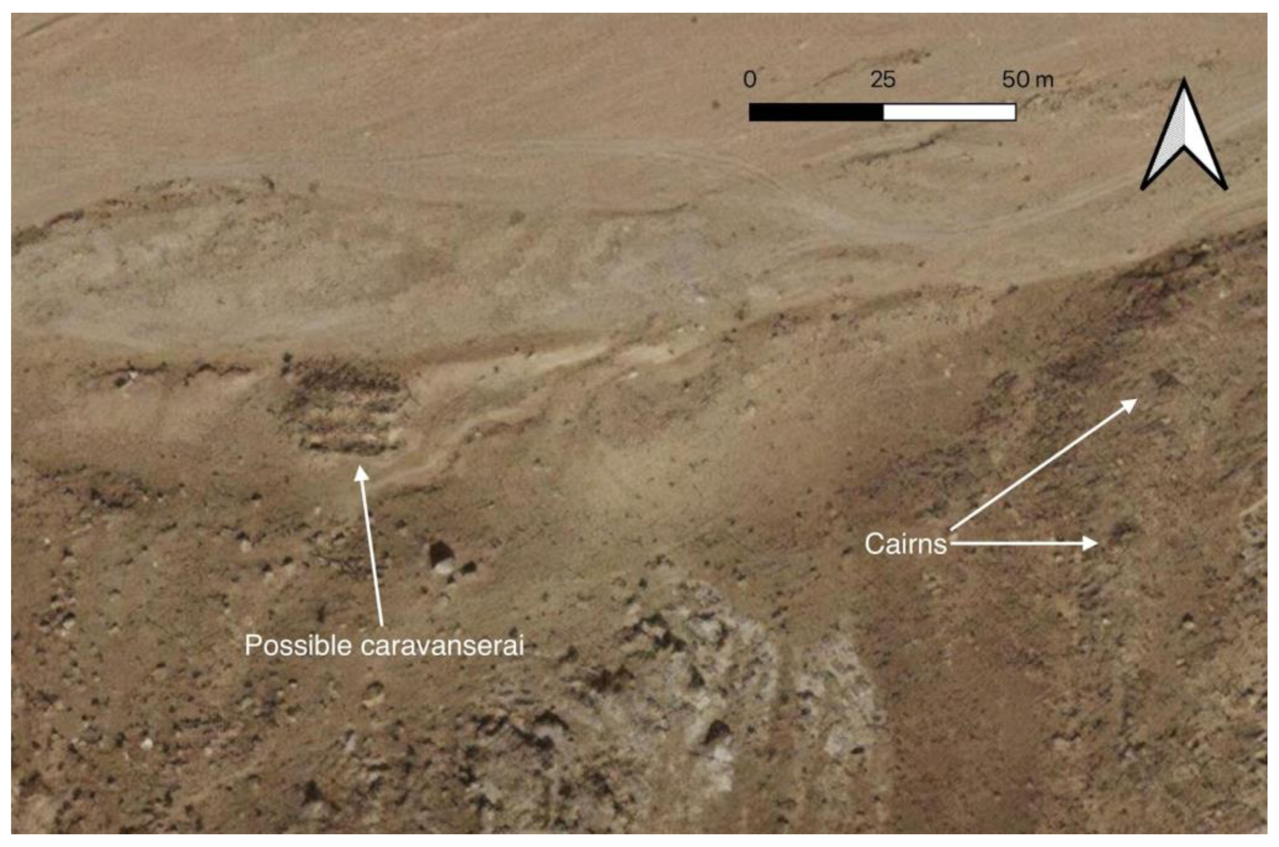
4.1. A Pre-Islamic Caravanserai?
4.2. Landscapes of Movement
4.3. Cultural Bounds
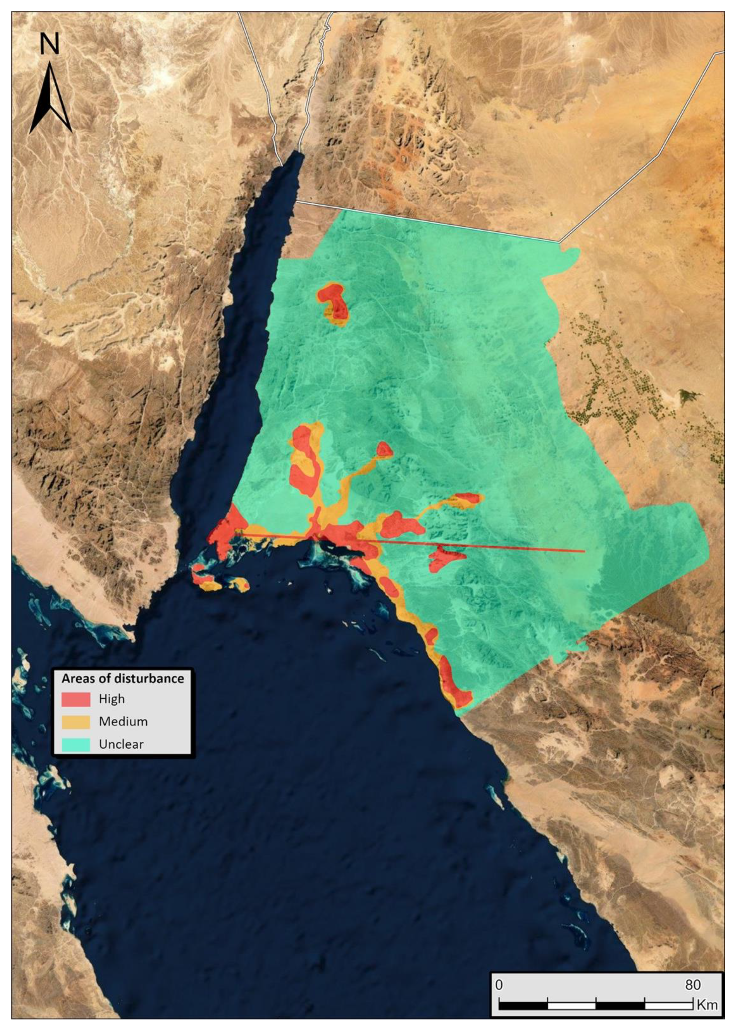
4.4. Predicting the Impact of the Neom Development
5. Conclusions
Author Contributions
Funding
Data Availability Statement
Acknowledgments
Conflicts of Interest
References
- Almazroui, M.; Islam, M.N.; Saeed, S.; Saeed, F.; Ismail, M. Future Changes in Climate over the Arabian Peninsula based on CMIP6 Multimodel Simulations. Earth Syst. Environ. 2020, 4, 611–630. [Google Scholar] [CrossRef]
- Thomas, M.; Venema, V. Neom: What’s the Green Truth Behind a Planned Eco-City in the Saudi Desert? Available online: https://www.bbc.co.uk/news/blogs-trending-59601335 (accessed on 13 August 2022).
- Heathcote, E. Saudi’s Neom is Dystopia Portrayed as Utopia. Available online: https://www.ft.com/content/04fcb9d4-5907-45b0-9388-f84b34bc4bea (accessed on 26 September 2022).
- Akkad, D. Neom: Saudi Tribesman Sentenced to Death over Megaproject Protest ‘Was Tortured’. Available online: https://neom.middleeasteye.net/news/Neom-saudi-tribesman-sentenced-death-resistance-tortured (accessed on 12 October 2022).
- Pollastro, R.M. Geologic Provinces of the Arabian Peninsula and Adjacent Areas, 2000 (prv2bg); U.S. Geological Survey: Reston, VA, USA, 1998. [Google Scholar]
- U.S. Geological Survey. Geological Map of the Arabian Peninsula; IMAP 270-A: Washington, DC, USA, 1963. [Google Scholar]
- Ingraham, M.L.; Johnson, T.D.; Rihani, B.; Shatla, I. Saudi Arabia Comprehensive Survey Program: Preliminary report on a reconnaissance survey of the Northwestern province (with a note on a brief survey of the Northern province). Atlal J. Saudi Arab. Archaeol. Riyakd 1981, 5, 59–84. [Google Scholar]
- Finlayson, B.; Mithen, S. The Dana-Faynan (South Jordan) Epipalaeolithic Project: Report on Reconnaissance Survey. Levant 1998, 30, 27–32. [Google Scholar] [CrossRef]
- Finlayson, B.; Mithen, S. The Early Prehistory of Wadi Faynan, Southern Jordan: Archaeological Survey of Wadis Faynan, Ghuwayr and Al-Bustan and Evaluation of the Pre-Pottery Neolithic A Site of WF16; Oxbow: Oxford, UK, 2007. [Google Scholar]
- Mithen, S.; Finlayson, B.; Maričević, D.; Smith, S.; Jenkins, E.; Najjar, M. WF16 Excavations at an Early Neolithic Settlement in Wadi Faynan, Southern Jordan; Stratigraphy, Chronology, Architecture and Burials; CBRL: London, UK, 2018. [Google Scholar]
- Macdonald, B. Neolithic Period (ca. 9700–4900 BCE) Presence in the Southern Transjordan Plateau, the Southern Ghors, Wadis Fidan and Faynan, and the East Side of Wadi Arabah. In The Socio-economic History and Material Culture of the Roman and Byzantine Near East: Essays in Honor of S. Thomas Parker; Ward, W.D., Ed.; Gorgias Press: Piscataway, NJ, USA, 2017. [Google Scholar]
- Thomas, H.; Kennedy, M.A.; Dalton, M.; McMahon, J.; Boyer, D.; Repper, R. The mustatils: Cult and monumentality in Neolithic north-western Arabia. Antiquity 2021, 95, 605–626. [Google Scholar] [CrossRef]
- Kennedy, M.A.; McMahon, J.; Thomas, H.; Boyer, D.D.; Repper, R.; Dalton, M.; AlKhaldi, K. Dating the pendant burials of north-west Arabia: First radiometric results from the Khaybar Oasis, Saudi Arabia. Am. J. Transplant. 2021, 32, 183–197. [Google Scholar] [CrossRef]
- Inglis, R.H.; Sinclair, A.; Alsharekh, A.; Scott, C.; Al Otaibi, D. The Palaeolithic of the northern Red Sea—new investigations in Tabuk and Al-Jawf provinces, Saudi Arabia. Proc. Semin. Arab. Stud. 2019, 49, 167–186. [Google Scholar]
- Breeze, P.S.; Groucutt, H.S.; Drake, N.A.; White, T.S.; Jennings, R.P.; Petraglia, M.D. Palaeohydrological corridors for hominin dispersals in the Middle East ∼250–70,000 years ago. Quat. Sci. Rev. 2016, 144, 155–185. [Google Scholar] [CrossRef]
- Luciyana, M. Mobility, Contacts and the Definition of Culture(s) in New Archaeological Research in Northwest Arabia. In The Archaeology of North Arabia: Oases and Landscapes; Luciana, M., Ed.; Austrian Academy of Sciences Press: Vienna, Austria, 2016; ISBN 978-3-7001-8002-9. [Google Scholar]
- Hüneburg, L.; Hoelzmann, P.; Knitter, D.; Teichert, B.; Richter, C.; Lüthgens, C.; Alsaud, A.S.; Luciani, M. Living at the wadi—integrating geomorphology and archaeology at the oasis of Qurayyah (NW Arabia). J. Maps 2019, 15, 215–226. [Google Scholar] [CrossRef] [Green Version]
- Charloux, G.; AlMalki, T.; AlQaeed, A. The “walled oases” phenomenon. A study of the ramparts in Dūmat al-Jandal and other pre-Islamic sites in north-western Arabia. Am. J. Transplant. 2021, 32, 256–290. [Google Scholar] [CrossRef]
- Gawlikowski, M. Looking for Leuke Kome. In Stories of Globalization: The Red Sea and the Persian Gulf from Late Prehistory to Early Modernity, Manzo, A.; Zazzaro, C., de Falco, D.J., Eds.; Brill: Leiden, The Netherlands, 2018. [Google Scholar]
- Nappo, D. On the location of Leuke Kome. J. Rom. Archaeol. 2010, 23, 335–348. [Google Scholar] [CrossRef]
- Juchniewicz, K. The port of Aynuna in pre-Islamic period. Nautical and topographical considerations on the location of Leuke Kome. Pol. Archaeol. Mediterr. 2018, 26, 31–42. [Google Scholar] [CrossRef] [Green Version]
- Fiema, Z.T.; Nehmé, L.; Al-Talhi, D.; Kennedy, W. The al-Ulā–al-Wajh Survey Project: 2013 Reconnaissance Season. Atlal 2020, 29, 109–121. [Google Scholar]
- Charloux, G.; Sahlah, S.A.; Badaiwi, W.A. Madian revealed? Assessing the history and archaeology of the oasis of al-Bad’ in northwestern Arabia. Semit. Class. 2021, 14, 97–142. [Google Scholar] [CrossRef]
- Kennedy, D. The “Works of the Old Men” in Arabia: Remote sensing in interior Arabia. J. Archaeol. Sci. 2011, 38, 3185–3203. [Google Scholar] [CrossRef]
- Fisher, M.; Fradley, M.; Flohr, P.; Rouhani, B.; Simi, F. Ethical considerations for remote sensing and open data in relation to the endangered archaeology in the Middle East and North Africa project. Archaeol. Prospect. 2021, 28, 279–292. [Google Scholar] [CrossRef]
- Kennedy, D.; Bewley, R. Ancient Jordan from the Air; Council for British Research in the Levant: London, UK, 2004. [Google Scholar]
- Fradley, M.; Hardouin, S. Remote Sensing of Endangered Archaeology on Gebel Ataqah, Egypt. PalArch J. Archaeol. Egypt Egyptol. 2019, 16, 1–21. [Google Scholar]
- Groucutt, H.S.; Breeze, P.S.; Guagnin, M.; Stewart, M.; Drake, N.; Shipton, C.; Zahrani, B.; Al Omarfi, A.; Alsharekh, A.M.; Petraglia, M.D. Monumental landscapes of the Holocene humid period in Northern Arabia: The mustatil phenomenon. Holocene 2020, 30, 1767–1779. [Google Scholar] [CrossRef]
- Wilkinson, T.J. Archaeological Landscapes of the Near East; University of Arizona Press: Tuscon, AZ, USA, 2003. [Google Scholar]
- Aldred, O. The Archaeology of Movement; CRC Press: London, UK, 2021. [Google Scholar]
- Kennedy, D. Two Nabataean and Roman Sites in Southern Jordan: Khirbet el-Qirana and Khirbet el-Khalde. In Oikistes: Studies in Constitutions, Colonies, and Military Power in the Ancient World. Offered in Honor of A. J. Graham; Gorman, V.B., Robinson, E.W., Eds.; Brill: Leiden, The Netherlands, 2002; pp. 361–386. [Google Scholar]
- Issac, B. The Limits of Empire: The Roman Army in the East; Clarendon Press: Oxford, UK, 1992. [Google Scholar]
- Abudanah, F.; Taraneh, M.B.; Twaissi, S.; Wenner, S.; Al-Salameen, A. The Via Nova Traiana Between Petra and Ayn Al-Qana in Arabia Petraea: Via Nova Traiana in Arabia Petraea. Oxf. J. Archaeol. 2016, 35, 389–412. [Google Scholar] [CrossRef]
- Dalton, M.; McMahon, J.; Kennedy, M.; Reppe, R.; al Shilali, S.E.; AlBalawi, Y.; Boyer, D.; Thomas, H. The Middle Holocene ‘funerary avenues’ of north-west Arabia. Holocene 2022, 32, 183–199. [Google Scholar] [CrossRef]
- Nadel, D.; Malkinson, D.; Bar-Oz, G.; Nachmias, A.; Avner, U.; Horowitz, L.K.; Porat, N. 2021. Small, Sparse and Effective: The Negev and Sinai kites. In The Gazelle’s Dream: Game Drives of the Old and New Worlds; Betts, A., van Pelt, P., Eds.; Sydney University Press: Sydney, Australia, 2021; pp. 253–304. [Google Scholar]
- Repper, R.; Kennedy, M.; McMahon, J.; Boyer, D.; Dalton, M.; Thomas, H.; Kenndy, D. Kites of Al Ula County and the Harrat Uwayrid, Saudi Arabia. Arab. Archaeol. Epigr. 2022, 33, 3–22. [Google Scholar] [CrossRef]
- Barge, O.; Albukaai, D.; Boelke, M.; Guadagnini, K.; Régagnon, E.; Crassard, R. New Arabian desert kites and potential proto-kites extend the global distribution of hunting mega-traps. J. Archaeol. Sci. Rep. 2022, 42, 103403. [Google Scholar] [CrossRef]
- Guagnin, M.; Shipton, C.; Al-Rashid, M.; Moussa, F.; El-Dossary, S.; Bin Sleimah, M.; Alsharekh, A.; Petraglia, M. An illustrated prehistory of the Jubbah oasis: Reconstructing Holocene occupation patterns in north-western Saudi Arabia from rock art and inscriptions. Am. J. Transplant. 2017, 28, 138–152. [Google Scholar] [CrossRef]


Publisher’s Note: MDPI stays neutral with regard to jurisdictional claims in published maps and institutional affiliations. |
© 2022 by the authors. Licensee MDPI, Basel, Switzerland. This article is an open access article distributed under the terms and conditions of the Creative Commons Attribution (CC BY) license (https://creativecommons.org/licenses/by/4.0/).
Share and Cite
Fradley, M.; Gyngell, S. Landscapes of Mobility and Movement in North-West Arabia: A Remote Sensing Study of the Neom Impact Zone. Land 2022, 11, 1941. https://doi.org/10.3390/land11111941
Fradley M, Gyngell S. Landscapes of Mobility and Movement in North-West Arabia: A Remote Sensing Study of the Neom Impact Zone. Land. 2022; 11(11):1941. https://doi.org/10.3390/land11111941
Chicago/Turabian StyleFradley, Michael, and Sarah Gyngell. 2022. "Landscapes of Mobility and Movement in North-West Arabia: A Remote Sensing Study of the Neom Impact Zone" Land 11, no. 11: 1941. https://doi.org/10.3390/land11111941