Article

Spatial Driven Effects of Multi-Dimensional Urbanization on Carbon Emissions: A Case Study in Chengdu-Chongqing Urban Agglomeration

1
School of Economics, Jilin University, Changchun 130012, China
2
College of Geographical Sciences, Southwest University, Chongqing 400700, China
3
School of Resources and Environment, Nanchang University, Nanchang 330031, China
4
Central China Research Center for Economic and Social Development, Nanchang University, Nanchang 330031, China
*
Author to whom correspondence should be addressed.
Land 2022, 11(10), 1858; https://doi.org/10.3390/land11101858
Submission received: 9 September 2022 / Revised: 1 October 2022 / Accepted: 6 October 2022 / Published: 20 October 2022

Abstract

:
Previous studies lacked attention to the spatial heterogeneity of the impact of urbanization on carbon emissions. To fill this knowledge gap, this study analyzed the spatio-temporal variations of carbon emissions (TCE), the per capita carbon intensity (PCI), and the economic carbon intensity (ECI) in the Chengdu-Chongqing urban agglomeration (CUA) based on the Open-Data Inventory for Anthropogenic Carbon dioxide (ODIAC) from 2000–2018. Bivariate spatial autocorrelation, and spatial Durbin models were combined to quantify the spatial correlation and driving mechanisms between carbon emission intensity and multi-dimensional urbanization (population, economic, and land urbanization). The following are the main results: (1) The TCE in CUA increased by 3.918 million tons at an average annual growth of 6.86%; CUA ranked last among China’s national strategic urban agglomerations in terms of TCE, PCI, and ECI. (2) High carbon emission values were concentrated in the Chengdu and Chongqing metropolitan areas, presenting a spatial feature of “Core-Periphery” gradient decay. (3) Nearly 30% of the agglomeration had carbon emission growth at low rates, with the growth cores concentrated in the main urban areas of Chengdu and Chongqing. (4) The “Low-Low” positive correlation was the main correlation type between multi-dimensional urbanization and carbon emissions and was distributed mainly in mountainous areas (e.g., Leshan and Ya’an). (5) Among the urbanization dimensions, the impacts on carbon emissions in local and adjacent areas exhibited varying levels of spatial heterogeneity. Economic urbanization was found to have the strongest positive direct and spillover effects; land urbanization inhibited the growth of carbon emissions in local and adjacent areas; population urbanization promoted carbon emission reduction in adjacent areas. Our findings provide support for CUA to carry out cross-city joint governance strategies of carbon emissions, also proving that regional carbon emission reduction should be an integration of various efforts including low-carbon living of residents, green transformation of economy and optimal land management.

1. Introduction

Since the mid-20th century, climate change characterized by global warming has profoundly affected human society and the global environment, causing sea level rise, sharp declines in biodiversity, urban heat island effects, and a global decrease in agricultural production [1]. According to the 6th Assessment Report of the Intergovernmental Panel on Climate Change (IPCC AR6), carbon dioxide produced by fossil fuel consumption and human production is the main cause of global warming [2]. In 2018, the global energy-related carbon emissions increased to 33.6 billion tons, while the atmospheric carbon dioxide concentration has risen to its highest level in at least two million years [3]. Net-zero emissions and accelerated carbon neutrality have become major targets in global climate governance to achieve sustainable urban construction (Goal11, SDG), effective climate change response (Goal13, SDG), and ecosystem protection (Goal15, SDG) in the Anthropocene.
The IPCC have confirmed the considerable impact of human settlements and urbanization on the intensification of global carbon emissions [4,5]. As the world’s largest emitter of carbon dioxide, China’s carbon emissions were estimated to be about 9.6 billion tons, accounting for 28.57% of total global carbon emissions in 2018 (WDI, 2021). The country’s carbon emissions have increased in parallel with the rapid rise in urbanization since the economic opening up and reforms in 1978 [6]. In recent years, China has implemented emission reduction efforts addressing climate change; for instance, the “double carbon” goals (i.e., peak carbon by 2030 and carbon neutral by 2060) proposed at the Climate Ambition Summit have become central to China’s environmental policies and serve as an important node in the world’s carbon reduction process [7,8]. The World Bank report suggests that by 2030, 70% of China’s population will live in urban areas. The high carbon consumption of residents and industries will accelerate the growth of carbon emissions, posing severe challenges to regional emission reduction and carbon governance [9]. Exploring the driving mechanisms of urbanization on carbon emissions is essential in developing low-carbon sustainable cities and alleviating the pressure of net-zero emissions in China and the world.
There has been no consensus on whether urbanization has a positive or negative on carbon emissions and whether it is consistent with the environmental Kuznets curve (“EKC”) hypothesis [10,11,12]. Some studies have suggested that urbanization contributes to carbon-related climate deterioration by affecting economic growth, energy efficiency, and energy mix [13]. Others argue that the urbanization process is often accompanied by the development of green product markets and low-carbon production, which could indirectly reduce carbon emissions [14]. The inverted U-shaped relationship between urbanization and carbon emissions has also been found in previous studies [15]. The carbon-increasing effect of rapid urbanization will gradually converge under the influence of the residents’ environmental demands, green production technology upgrading, and environmental policy guidance, eventually achieving emission reduction targets and carbon neutrality [16].
Existing controversies go far beyond this, as studies on the spatial heterogeneity effects of urbanization on carbon emissions and the variability of impacts within urbanization systems (e.g., population, economic, and land urbanization) have also had varying and contradictory results. For example, Liu et al. (2021) found that economic urbanization accelerates the upgrading of production technologies and promotes carbon emission reduction [17]. This contradicts the conclusions of Wang et al. (2022) that suggest the considerable impact of economic urbanization on energy consumption and regional carbon emission growth [14]. Zhang et al. (2018) found significant spatial spillover effects of population urbanization on carbon emissions in adjacent areas, while the impact of land urbanization on carbon emissions occurs mainly remained local [5]. Liu et al. (2021) found that economic urbanization had a strong inhibitory effect on carbon emissions in the Yangtze River Economic Belt, while the impact of population urbanization for the given study period was not significant [7]. Given that research on the impact of urbanization on carbon emissions has been inconclusive, more studies and investigations are needed to better understand the heterogeneous effects of different urbanization dimensions on carbon emissions.
In addition, previous studies have largely focused on the driving effects of urbanization in highly developed urban agglomerations, such as the Yangtze River Delta and the Beijing-Tianjin-Hebei [6,18,19]. Little attention has been given to China’s central and western regions, even though they are already key areas for industrial transfer and construction. While various approaches and models (e.g., Pearson correlation coefficient, IPAT model, STIRPAT model, and environmental Kuznets index) have been used to analyze the relationship between urbanization and carbon emissions, few studies have explored its spatial variabilities, which can be useful in developing and improving regional carbon governance and carbon neutrality [20,21].
As a regional center where people, technology, information, resources, capital and other elements converge, urban agglomerations have become important support platforms for China’s rapid urbanization. The Chengdu-Chongqing urban agglomeration (CUA) is an emerging urban agglomeration approved by the State Council of China in 2016, and is one of China’s five national strategic urban agglomerations, alongside Beijing-Tianjin-Hebei (BTH), Yangtze River Delta urban agglomeration (YRDUA), Guangdong-Hong Kong-Macau-Great Bay Area (GBA), and Middle Yangtze River urban agglomeration (MYRUA). According to data from the National Bureau of Statistics of China, the population urbanization rate in the CUA increased from 50.10% (2000) to 66.71% (2018), with the GDP increasing from 4931.189 billion yuan (2000) to 5365.486 billion yuan (2018). And while urban development has promoted economic progress, it has also generated ecological problems, such as haze pollution, habitat degradation and declining net primary productivity of vegetation [22]. However, research on carbon emissions in the CUA has been scarce. To the best of our knowledge, only Zeng et al. (2022) analyzed the spatio-temporal evolution of carbon emissions in the CUA at the city level and explored the impact of energy intensity, economic development level, and population size [23].
While previous studies have explored the driving effects of urbanization on carbon emissions, the impact of rapid urbanization on carbon emission levels remains unresolved. (1) The spatial heterogeneity of the impact of urbanization on carbon emissions in local and adjacent regions requires further analysis. (2) The contrasting responses of carbon emissions to population, economic, and land urbanization must be further analyzed and differentiated. (3) Given that the driving mechanism of urbanization on carbon emissions varies geographically, there has been limited research on the driving effects, particularly in the CUA. In this study, the spatio-temporal evolution of carbon emissions in the CUA from 2000 to 2018 is analyzed using the Open-Data Inventory for Anthropogenic Carbon dioxide (ODIAC) and the GEE geographic cloud platform. The nighttime lighting remote sensing data and the Landsat land-use interpretation data are combined to assess the driving mechanisms of multi-dimensional urbanization on carbon emissions using the bivariate spatial autocorrelation, and spatial regression model. The differential driving effects of multi-dimensional urbanization are explored for local and adjacent areas based on partial differential equation (P.D.E.) decomposition. The results help provide a better understanding of the spatial effects of urbanization on carbon emissions and offer new insights into emission reduction measures and environmental governance, particularly in emerging urban agglomerations in China.

2. Study Area, Methods and Data Sources

2.1. Study Area

The CUA is located at the intersection of “the Belt and Road” and Yangtze River Economic Belt strategies, with Chongqing and Chengdu as core, and includes 14 other cities: Zigong, Luzhou, Deyang, Mianyang, Suining, Neijiang, Leshan, Nanchong, Meishan, Yibin, Guang’an, Dazhou, Ya’an, Ziyang (Figure 1). Based on the need for fine-grained analysis, the sampling requirements for the regression, and the availability of statistical data in the control variables, the assessment and analyses were conducted using geographic grid units and administrative divisions.

2.2. Methods

2.2.1. Carbon Emission Intensity Accounting

The spatio-temporal variations of total carbon emissions (TCE), the per capita carbon intensity (PCI), and the economic carbon intensity (ECI) in the CUA were used in the assessment of carbon emission levels (Figure 2) [24]. The PCI and ECI were calculated based on the population, GDP, and TCE of the county-level units using the following equations:
P C I = C O 2 / P O P
E C I = C O 2 / G D P
where POP and GDP are the total population and the gross domestic product of the 142 county-level units in the CUA, respectively.

2.2.2. Slope Trend Analysis

Slope trend analysis is a mathematical calculation exploring the linear variation characteristics of variables to avoid the randomness and contingency of the study results. By fitting the data for all years, the regression slope of the variables can be obtained and used to reflect the linear relationship between each unit attribute and time [25]. To analyze the temporal trends for the TCE, the slope of the trend line (Slope) was calculated using the formula:
S l o p e = n i = 1 n ( i Y i ) i = 1 n i i = 1 n Y i n i = 1 n i 2 ( i = 1 n i ) 2
where Y is the variable attribute of each study unit; n is the time span (n=19); i is the annual variable. When Slope is greater than 0, the attribute value has an increasing trend over time; when Slope is less than 0, the attribute value has a decreasing trend over time; when Slope is equal to 0, the attribute value is neither increasing nor decreasing.

2.2.3. Analysis of Driving Effect

The bivariate spatial autocorrelation model was used to detect the spatial correlation between urbanization and carbon emissions. This method is an extension of the traditional spatial autocorrelation analysis and can be used to test for local non-stationarity in the response of carbon emissions to urbanization. Using the Multivariate LISA tool of GeoDa 1.4.6, the bivariate local spatial autocorrelation method was used to quantify the spatial correlation characteristics of the population, economy, land urbanization, and carbon emissions [26,27]. The calculation formula for the bivariate Moran’ I is as follows:
I k l i = x k i x ¯ k σ k j = l n ( W i j x l j x ¯ l σ l )
where Wij is the spatial weight matrix; x k i is the observed value k of study unit i; x l j is the observed value l of study unit j; σk and σl are the variances of xk and xl, respectively. The value range of I is between [−1, 1]. A value greater than 0 indicates a positive correlation, wherein similar variables tend to be clustered in space; a value less than 0 indicates a negative correlation, wherein similar variables tend to be discrete.
Bivariate spatial autocorrelations only reflect the underlying correlation between variables and may not be able to properly express possible spatial heterogeneity of the driving effects. The spatial regression model can solve this problem as it considers the effect of spatial dependence on the regression coefficients. There are three common spatial regression models: spatial error model (SEM), spatial lag model (SLM), and spatial Durbin model (SDM). The SDM integrates the quantitative advantages of SEM and SLM for variable exogenous and endogenous interaction effects and can partition the driving effects of urbanization on carbon emissions into local direct effects, spatial spillover effects, and total effects based on partial differential equations (P.D.E.) [28]. The formula of the SDM equation is as follows:
Y i t = ρ W Y i t + β X i t + θ W X i t + α i + λ t + ε i t
where Yit is the explanatory variable for region i in period t, i.e., carbon emissions; Xit is the explanatory variable for region i in period t, including multi-dimensional urbanization and control variables; α and λ are individual and periodic effects, respectively; ε is the random disturbance term of normal distribution; ρ, β, and θ are parameters to be estimated; W is the spatial weight matrix; WY is the spatial lagged dependent variable; WX is the spatial error independent variable.
To improve the scientific validity of the model runs, some variables were logarithmized to eliminate heteroskedasticity. Possible multicollinearity among the variables was also tested based on the variance inflation factor (VIF). Lagrange multipliers (LM) and likelihood ratio (LR) estimates were used to evaluate the necessity of including spatial effects in the model and the choice of the optimal model (either SEM, SLM, or SDM). According to Du et al. (2021), in the LR estimation, if ρβ + θ = 0 passes the significance test, SDM can be simplified to SEM; if θ = 0 passes the significance test, SDM can be simplified to SLM; if both pass, the SDM is most suitable for the regression analysis [28]. The correlation operations and tests were run in the MATLAB Spatial Regression Toolbox.

2.3. Data Sources

2.3.1. Multi-Dimensional Urbanization

Urbanization is a complex system process that includes multiple subsystems such as population, economy, space, and society. Based on the recommendations and experiences of previous studies, we measured the urbanization level of the CUA from three dimensions: population, economy, and land. Population urbanization is usually measured by the proportion of the urban population to the total population, reflecting the change in spatial structure by the population migration from rural to urban areas. The data on the urban population was obtained from the Sichuan Statistical Yearbook and Chongqing Statistical Yearbook [29].
Land urbanization is expressed by the ratio of urban land area to total land area, indicating the increase in urban construction lands and the decline of rural areas [6]. The data was obtained from the land use remote sensing monitoring dataset provided by the Resources and Environmental Sciences of the Chinese Academy of Sciences. The dataset was based on Landsat TM/ETM and Landsat 8 remote sensing images and contains six primary land-use types (i.e., arable land, forest land, grassland, water, residential land and unused land) and 25 secondary types determined through manual visual interpretation (https://www.resdc.cn/, accessed on 31 August 2022).
Economic urbanization reflects the industrial transformation and production scale and is usually measured by the proportion of the non-agricultural economy. Peng et al. (2017) and Wang et al. (2021) found that GDP density is a good proxy for the non-farm economic share. Given the available data for this study, GDP density was used to indicate the level of economic urbanization [29,30]. The data was obtained from the grid dataset of GDP density in China constructed by the Data Center for Resources and Environmental Sciences of the Chinese Academy of Sciences, with a spatial resolution of 1 km and a unit of 10,000 yuan/km2 (https://www.resdc.cn/, accessed on 31 August 2022).

2.3.2. Carbon Emissions

Most of the datasets used for carbon emission studies are from the Emissions Database for Global Atmospheric Research (EDGAR), the British Petroleum (BP) carbon emission reports, and other global carbon emission statistics [31]. China has also established carbon accounting databases (China Emission Accounts and Datasets, CEADs) in recent years providing multi-scale energy and carbon emission inventory data for China. However, these data are mostly national scale or statistical panel data, which can be problematic when evaluating the spatial distribution pattern of carbon emissions at the image element level. In this study, the spatio-temporal evolution of carbon emissions in the CUA from 2000–2019 was analyzed using the Open-Data Inventory for Anthropogenic Carbon dioxide (ODIAC) [32]. The dataset is from the Greenhouse Gas Observing Satellite (GOSAT) project of the National Institute for Environmental Studies (NIES) of Japan, and the data products provide global month-by-month CO2 emission data (emission sources are mainly fossil fuel combustion, cement production, and natural gas combustion, with a spatial resolution of 1 km). The annual carbon emission raster dataset for the CUA was generated by adding the average monthly data and cropping based on the GEE platform. Carbon emission index data for 142 county-level units were obtained using the zonal statistics tool on ArcGIS platform.

2.3.3. Control Variable Data

As used in previous research, the proportion of output value for the secondary industry, the total retail sales of social consumer goods, the amount of actual utilization of foreign investment, and the total investment in real estate development were used in this study to indicate the error effects of industrial structure, commercial trade, foreign investment input, and real estate development on carbon emissions, respectively [33,34,35]. These data were acquired from the National Bureau of Statistics of China, the Statistical Yearbook of Sichuan Province, and the Statistical Yearbook of Chongqing City. For natural control variables, elevation, average temperature, wind speed, average annual precipitation, and normalized vegetation index (NDVI) were used to reflect the error effects of the natural environment on carbon emissions [36,37,38] (Table 1). The data for elevation, average temperature, wind speed, and average annual precipitation were taken from the spatial dataset of meteorological conditions provided by the National Earth System Science Data Center of China (http://www.geodata.cn/, accessed on 31 August 2022). The NDVI spatial distribution was obtained from satellite remote sensing data (e.g., SPOT/VEGETATION and MODIS), and the 1km-spatial resolution vegetation cover datasets were generated using projection transformation and mosaic stitching (https://www.resdc.cn/data.aspx?DATAID=343, accessed on 31 August 2022).

3. Results

3.1. Spatial and Temporal Distribution Patterns of Carbon Emissions

3.1.1. Overall Trend of Change

Figure 3 shows the overall changes in carbon emissions in the CUA. The results show that carbon emissions from the CUA have generally maintained stable growth, with the TCE increasing from 1.789 million tons in 2000 to 5.707 million tons in 2018 at an average annual growth rate of 6.86%. The results also show that the carbon emissions in the CUA have been largely focused on the regional center cities (i.e., Chengdu and Chongqing), similar to the other four national strategic urban agglomerations (Figure 4). Compared with the other urban agglomerations, the CUA had the lowest carbon emissions in general, but the carbon emission increase for 2000–2018 reached 230.07%, far exceeding MYRUA, BTH, and GBA. In terms of carbon intensity, YRDUA and GBA had the highest PCI and ECI, while the CUA had the lowest values. The average PCI and ECI values in the CUA for 2018 were 0.059 t/person and 0.035 t/10,000yuan, respectively.

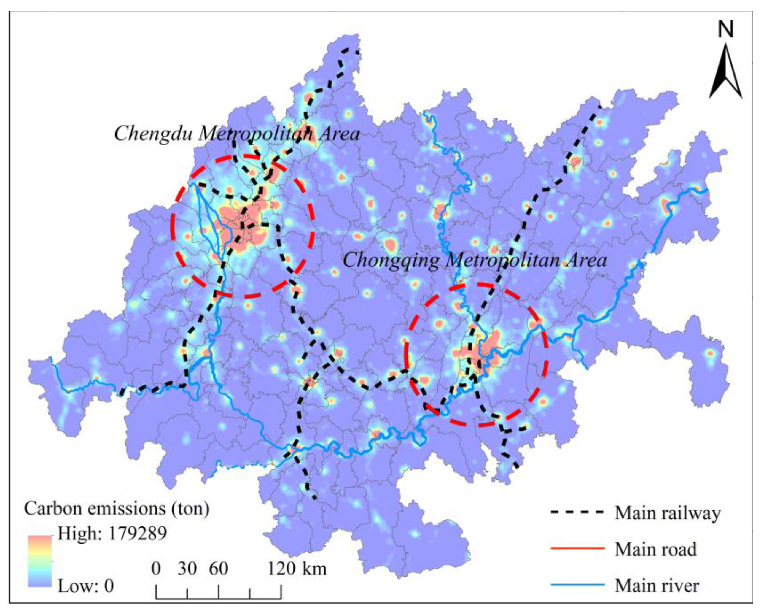
3.1.2. Spatial Distribution Pattern

The carbon emission data for 2000–2018 was processed using ArcGIS to obtain the spatial average carbon emission of CUA (see Figure 5). The figure shows a spatial pattern of high emission values in the Chengdu and Chongqing Metropolitan areas, gradually dissipating towards the peripheries. Aside from the urban centers, high carbon emission values can be found along the railroads and rivers, possibly due to the long history of urban construction, the high concentration of population and industries in these areas.
ArcGIS-based regional statistical tools and spatial interpolation were used to analyze the distribution patterns for TCE, PCI and ECI at the administrative division level (see Figure 6). In terms of TCE, the increases in TCE values were in or near the Chengdu and Chongqing metropolitan areas. In 2000, high-value areas for TCE were mainly scattered in Qijiang District, Jiangyou City, and Gao County; by 2010 and 2018, the high-value areas were clustered in the Chengdu and Chongqing metropolitan areas, particularly in Qijiang District, Hechuan District, Yubei District in Chongqing and Shuangliu District and Wuhou District in Chengdu, where TCE exceeded 160,000 tons in 2018. This could be caused by the “strong provincial capital” policy implemented in recent years, which has produced substantial productive enterprises and factories in the region, generating higher demand for energy consumption.
In terms of PCI, the values in the CUA have continued to increase, with the high-value areas presenting a stable fragmented and dispersed distribution characteristic. In 2000, the high-value areas for PCI were scattered in the edge counties, such as Qianfeng District, Gaoxian County, Hechuan District, Gong County, and Changning County; this distribution pattern remained unchanged in 2010 and 2018. This means that the amount of carbon emissions per unit in these regions remains high and that carbon efficiency and environmental awareness should be urgently improved.
Although the average ECI declined from 0.043 t/10,000 yuan in 2000 to 0.023 t/10,000 yuan in 2010, and then to 0.012 t/10,000 yuan in 2018, it maintained a fragmented distribution pattern similar to that of the PCI. In 2000, the high-value areas for ECI were scattered in Gao County, Qianfeng District, Gongxian County, Qijiang District, and the Neijiang City Central District; the ECI in these areas exceeded 0.170 t/10,000 yuan. In 2010 and 2018, these urban areas remained the core of high ECI values, but the gap with the surrounding areas decreased significantly (variation coefficient of ECI in CUA decreased from 1.971 in 2000 to 1.676 in 2018). This indicates that the CO2 produced per unit of GDP has been gradually converging, which may be related to better regional green production standards and technological advancements. For example, the Chengdu-Chongqing Urban Agglomeration Development Plan released in 2016 sets out detailed requirements for energy conservation in industry, construction, and transportation. The recently promulgated Joint Action Plan for Carbon Neutralization in the Twin Cities Economic Circle of Chengdu and Chongqing also provides specific action plans for the low-carbon transformation of industries and the region-wide promotion of green technologies.

3.2. Spatial Change Trend of Carbon Emissions

The spatial trends of carbon emissions were quantified using the Slope trend method. As shown in Figure 7, the changes in carbon emissions in the CUA showed considerable spatial heterogeneity. About 70.28% of the agglomeration showed a convergence trend; these areas are mainly located around urban agglomerations, in mountainous terrains, and those with relatively high forest coverage and more complete carbon cycle systems. The core of carbon emission growth was in the main urban areas of Chengdu and Chongqing, where the slope index exceeds 300, accounting for 0.01% of the total area. As the central cities of the agglomeration, the rapid urbanization of Chengdu and Chongqing has attracted a large urban population and generated an industrial agglomeration effect, causing high carbon product and energy consumption demand and accelerating CO2 emissions. Note that 28.82% of the agglomeration has a slope index in the 1–15 range, indicating that the growth of carbon emissions in the CUA is dominated by low growth rates.

3.3. Analysis of the Driving Effect of Multi-Dimensional Urbanization on Carbon Emissions

3.3.1. Spatial Correlation Effect of Multi-Dimensional Urbanization and Carbon Emissions

We calculated the indices for the population, economic, and land urbanization of the 142 county-level units in the CUA, and the local variability of the spatial association between multi-dimensional urbanization and carbon emissions was quantified using the bivariate local spatial autocorrelation tool on the GeoDA platform. As shown by the results in Figure 8, the “Low-Low” positive correlation was the main cluster type, while the proportion of the “High-High” positive correlation gradually increased in the association effect. County units where carbon emissions clustering positively correlated with population, economic, and land urbanization increased from 14.08%, 20.42%, and 20.42% in 2000 to 28.87%, 27.46%, and 29.58% in 2018. This implies that the synergistic growth trend of multi-dimensional urbanization and carbon emissions has accelerated significantly and that urbanization strategies have to be urgently adjusted to accommodate regional carbon emission reduction targets.
In terms of population urbanization, the “Low-Low” positive correlation cluster in 2000 was distributed mainly in Leshan and Ya’an counties. Other than some areas in the region (e.g., Asbestos County, Shawan District, and Jinkouhe District) with high levels of population urbanization, most of the areas are located in mountainous areas with relatively high vegetation coverage, thus having a perfect carbon cycle system and considerable urban development constraints. By 2010, the “High-High” positive correlation cluster gathered in the southeastern areas of Chongqing, such as Banan District, Jiangjin District and Bishan District, accounting for 4.23% in 2000 to 7.04% in 2010. By 2018, the “Low-Low” positive correlation agglomeration had spread in the southwestern mountainous regions, while the “High-High” positive correlation clustering further increased to 12.68%, the main urban areas of Chongqing and Chengdu (e.g., Shapingba District, Yuzhong District, Qingyang District, Wenjiang District, and Wuhou District) exhibited a synergistic growth in population urbanization and high carbon consumption due to the rapid agglomeration of urban residents. In terms of economic urbanization, the “Low-Low” positive correlation was the dominant cluster type and mainly distributed in some counties of Ya’an, Leshan, and Nanchong, with the proportion increasing from 16.90% in 2000 to 19.72% in 2018. By 2018, the Chengdu and Chongqing metropolitan areas were surrounded by a “Low-High” negative correlation cluster (area of about 9.15%), which included Dujiangyan City, Pengzhou City, Jinyang City, Banan District, and Nanchuan District. While the economic urbanization levels in these areas were less than 100 million yuan/km2, their geographical proximity to main urban areas resulted in relatively high urban population sizes, impervious surface coverages, and industry acceptance, resulting to release a large amount of CO2 from production and living sources. In both 2000, 2010 and 2018, the correlation between land urbanization and carbon emissions had a similar distribution pattern to the economic urbanization-carbon emissions relationship. This association may be related to the spatial synergy between urban land expansion and economic construction and the coordination of economic and land factor inputs in urbanization.

3.3.2. Further Analysis of the Driving Effect of Multi-Dimensional Urbanization on Carbon Emissions

After the logarithmization and standardization of variables, several indicators (i.e., total retail sales of consumer goods, actual utilization of foreign capital, total investment in real estate development, average annual precipitation, and NDVI) were excluded to avoid multicollinearity among variables. Using the LM test for spatial lag and spatial error, the LR-SLM, and the LR-SEM, the original hypothesis was rejected at the 1% confidence level. Therefore, the SDM model was selected to fit the driving effects of multi-dimensional urbanization on carbon emissions. The results of the SDM estimation and correlation test are shown in Table 2.
The results show that the positive effects of population urbanization and economic urbanization on carbon emissions significantly increased over time, especially in 2018, when the regression coefficients were 0.440 and 0.381, respectively. The effect of land urbanization on carbon emissions was not significant in 2000, but it contributed positively to carbon reduction in 2018 with a regression coefficient of −0.023. The differential impact of the secondary industry on carbon emissions was also evaluated. The regression coefficient in 2000 was 0.288 and −0.054 in 2018, implying that the impact of industrial structure on carbon emission reduction gradually shifted from inhibition to gain. Elevation, temperature and wind speed also had differential effects on regional carbon emissions. However, according to LeSage (2010) and Wei (2021), the marginal effects of the regression coefficients would be difficult to accurately measure, and the regression effects of key variables need to be further decomposed (i.e., direct, spillover, and total effects) to scientifically understand the spatial heterogeneity of the driving effects of multi-dimensional urbanization on carbon emissions [39,40].
Table 3 summarizes the decomposition estimation results of the driving effects of multi-dimensional urbanization on carbon emissions. The results suggest that the driving effects of urbanization on carbon emissions are usually ranked as follows: economic urbanization > land urbanization > population urbanization, where the positive effect of economic urbanization on carbon emissions is generally converging, while the negative effect of land urbanization on carbon emissions is rapidly increasing. This means that the amplification effect of economic urbanization on carbon emission levels in the CUA has gradually declined, while the reduction influence of land urbanization on carbon emissions has increased.
For population urbanization, the elasticity coefficients in both the direct effect (at the significance level) and the spillover effect (insignificant) were relatively small in 2000, but increased to 0.489 and -0.528 in 2018. For economic urbanization, the elasticity coefficient of the impact on local carbon emissions increased significantly from 0.603 (2000) to 0.622 (2018), while in adjacent areas, the value reached 1.183 in 2000 and was not significant in 2018. For land urbanization, the direct and spillover effects on the impact of carbon emissions were negative, with elasticity coefficients of −0.027 and −0.076 in 2000. The direct effect was not significant in 2018, while the elasticity coefficient of the impact on adjacent areas reached −0.144. Note that, except for land urbanization in 2018, the effects of multi-dimensional urbanization on local carbon emissions in each period were weaker compared to the adjacent areas. This means that the spatial spillover effect of urbanization dominates the local direct effect. The findings highlight the need for interregional governance and coordination for carbon emission control and urban construction.

4. Discussion

Urbanization is an integrated system involving various elements such as population concentration, land expansion, economic production, cultural integration and landscape ecological changes [41]. Different stages of urbanization will have varying effects on carbon emissions since they have differentiated governance strategies, planning schemes, environmental regulations, green production techniques, and economic development [42]. Previous studies have concluded that urbanization significantly contributes to regional carbon emissions, while others found its suppressive effect in developed countries and developed provinces [10,13]. In addition, in a unified and integrated system, different dimensions of urbanization have differential driving effects on carbon emissions since they represent different elements, including economy, socio-culture, land, technology, and capital, and this effect may vary by region, a view also confirmed by Muhammad et al., (2020), Wu et al., (2017) [43,44]. Our study shows that the effect of multi-dimensional urbanization on carbon emissions has significant spatial heterogeneity, which is similar to the significant variability of the driving effect of multi-dimensional urbanization on carbon emissions in local and adjacent area proposed in Chen et al. (2020) [11].

4.1. Driving Effects of Population Urbanization on Carbon Emissions in Local and Adjacent Regions

In terms of population urbanization, the direct effect is positive, while the spillover effect is negative; the intensity of the effect is intensifying, especially the elasticity coefficient of the direct effect increases from 0.010 to 0.489. On the one hand, urban population agglomeration increases carbon-related consumption, leading to higher carbon emissions. On the other hand, the increase in population mobility from regional integration produces a siphoning effect on the consumption market demand from the surrounding regions into main urban districts, indirectly weakening carbon-increasing effect of urbanization in the adjacent area [18].

4.2. Driving Effects of Economic Urbanization on Carbon Emissions in Local and Adjacent Regions

In terms of economic urbanization, the direct and spillover effects on carbon emissions are both positive, but their effect intensities diverge, with the elasticity coefficient of the direct effect increasing from 0.603 to 0.622 and the spillover effect decreasing from 1.183 to 0.786. Economic urbanization implies a large number of productive enterprises, high carbon product demand, and increased resource consumption that would accelerate CO2 levels from local construction [45]. Then, why does the amplifying effect of economic urbanization on carbon emissions gradually weaken in adjacent areas? One possible explanation is the industrial agglomeration effect [46]. With the support of industrial location theory and the tendency to “strengthen the provincial capital”, industrial enterprises often concentrate in cities, which have more pronounced advantages in capital, human resources, technology, and information, objectively reducing the pressure of carbon emission reduction generated by the economic urbanization of neighboring regions through industrial factor transfer.

4.3. Driving Effects of Land Urbanization on Carbon Emissions in Local and Adjacent Regions

For land urbanization, the results show that the direct and spillover effects are negative, consistent with the findings of some scholars, especially the absolute value of the elasticity coefficient of the spillover effect increases from 0.076 to 0.144. [6,16]. While urbanization entails land conversion and significant resource consumption, low-carbon and sustainable designs have incorporated urban planning that can effectively weaken the impact of urbanization on CO2 levels [47,48,49]. Improvements in land-use efficiency and local, high-quality ecological substrates also alleviate urbanization’s effect on the environment [50]. Due to the optimization policies in the CUA, the development of land-use intensification techniques has received greater attention from policymakers. The CUA also has a high-quality ecological substrate, guaranteeing the region’s strong ecosystem carbon cycling capacity. In particular, the mean NDVI value in the region increased from 0.712 in 2000 to 0.760 in 2018, which may cause land urbanization to have a neutralizing effect on carbon emissions [51,52,53]. Factors such as land planning, policies, and ecological substrate can considerably limit the amplifying impact of land urbanization on carbon emissions. And with land-use and ecological management improvements, particularly in urban built-up areas such as city parks, greenways, and open spaces, land urbanization would more likely have a positive effect on CO2 reduction in local and adjacent areas [54,55,56,57,58].

5. Conclusions

5.1. Main Conclusions

Previous studies have not thoroughly explored the differential impact of multi-dimensional urbanization on local and neighborhood carbon emissions. To address some of the current knowledge gaps, this study examined the spatio-temporal evolution trends of carbon emissions in the CUA from 2000–2018, analyzed the spatial correlation distribution patterns between urbanization and carbon emissions, and decomposed the driving effects using the P.D.E. The highlights of the findings are as follows: (1) The carbon emissions of the CUA increased by 3.918 million tons from 2000 to 2018 at an average annual growth rate of 6.86%. The carbon emission centers were concentrated in the Chengdu and Chongqing metropolitan areas and exhibited a “Core-Periphery” gradient decay feature. (2) Most regions of CUA experiencing low growth and the growth core situated in the main urban areas of Chengdu and Chongqing. The county units with a positive correlation have increased, and the “Low-Low” positive correlation is the main cluster type for urbanization-carbon emission association. (3) The direct and spillover effects varied significantly in different dimensions urbanization, with economic urbanization having the strongest positive direct and spillover effects.

5.2. Policy Implications, Shortcomings and Future Study

Although the CUA has the lowest TCE, PCI, and ECI values among the national strategic urban agglomerations in China, with the strategic overlap of the “Belt and Road” initiative, the Yangtze River Economic Belt, and the Western Development Strategy, the urban construction activities in the region are bound to have more considerable effects on carbon emissions. Based on the findings in this study, considerable work is needed to coordinate the harmonious relationship between urbanization and regional carbon control in the CUA.
First, given the heterogeneous effects of urbanization, policymakers must reconceptualize the coordination between multi-dimensional urbanization and carbon control using various perspectives, such as driving mechanisms, human-earth coordination, and system theory. The green transformation of industrial structures should be strengthened, and policies addressing low environmental awareness and cognition should be explored and implemented. Low-carbon measures for transportation and sustainable emission standards for enterprises should also be on the schedule, in line with the recommendations of the 26th Conference of the Parties (COP26) on carbon emissions from transportation and production enterprises. Urban planning and design should pay more attention to land productivity and approval control of undeveloped land to optimize resource use efficiency and avoid encroachments over crucial carbon sink systems, such as forests, grasslands and arable land. Inter-city and regional carbon governance should be emphasized, given the strong spillover effects of multi-dimensional urbanization on carbon emissions in adjacent areas. Joint carbon emission monitoring and environmental management should be encouraged to help achieve the goals of China’s Action Plan for Carbon Peaking by 2030 and the Joint Action Plan for Carbon Peaking and Carbon Neutralization in the Chengdu-Chongqing Region Twin-City Economic Circle. Deepen cooperation in the fields of industrial low-carbon transformation, urban-rural low-carbon integrated development, and ecological space construction, and be alert to the risk of carbon emission spillover from urban population flow, economic construction and urban expansion to build a low-carbon sustainable urban agglomeration.
There are some shortcomings in this study. First, while the Landsat images used in this study can generate regional land use structure, there is still room to improve the resolution of the dataset by using other remote sensing images. Future research can utilize global land-use datasets released by ESRI or ESA at 10 m resolution to improve the accuracy of quantifying the level of land urbanization. Second, this study focuses on the driving effect of multi-dimensional urbanization on carbon emissions in the CUA observed in previous years, but future development trends and possible correlation changes between variables were not thoroughly explored. Subsequent studies can explore the use of FLUS, CA-Markov, or deep learning methods to simulate and predict the development scenarios of urbanization and carbon emissions. Third, some of the remote sensing data used in this study may be affected by the noise brought by atmospheric conditions and clouds to some extent, and future studies will combine remote sensing technology to solve the error effects brought by these noises and increase the scientificity of data use.

Author Contributions

Conceptualization, J.C. and G.W.; methodology, P.S. and G.W.; software, J.C.; validation, J.C., G.W. and P.S.; formal analysis, J.C.; investigation, P.S.; resources, J.C.; data curation, G.W.; writing—original draft preparation, J.C.; writing—review and editing, P.S.; visualization, G.W.; supervision, J.C.; project administration, G.W.; funding acquisition, J.C. All authors have read and agreed to the published version of the manuscript.

Funding

This research received no external funding.

Informed Consent Statement

Not applicable.

Data Availability Statement

Not applicable.

Conflicts of Interest

The authors declare no conflict of interest.

References

  1. Allen, M.R.; Frame, D.J.; Huntingford, C.; Jones, C.D.; Lowe, J.A.; Meinshausen, M.; Meinshausen, N. Warming Caused by Cumulative Carbon Emissions Towards the Trillionth Tonne. Nature 2009, 458, 1163–1166. [Google Scholar] [CrossRef] [PubMed]
  2. Kahn, M.E.; Mohaddes, K.; Ng, R.N.; Pesaran, M.; Hashem, R.M.; Yang, J.C. Long-term macroeconomic effects of climate change: A cross-country analysis. Energy Econ. 2021, 104. [Google Scholar] [CrossRef]
  3. IEA. Global Energy & CO2 Status Report: The Latest Trends Inenergy and Emissions in 2018; IEA: Paris, France, 2019. [Google Scholar]
  4. Latief, R.; Kong, Y.S.; Javeed, S.A.; Sattar, U. Carbon Emissions in the SAARC Countries with Causal Effects of FDI, Economic Growth and Other Economic Factors: Evidence from Dynamic Simultaneous Equation Models. Int. J. Environ. Res. Public Health 2021, 18, 4605. [Google Scholar] [CrossRef]
  5. Zhang, X.M.; Brandt, M.; Tong, X.W.; Ciais, P.; Yue, Y.M.; Xiao, X.M.; Zhang, W.M.; Wang, K.L.; Fensholt, R. A large but transient carbon sink from urbanization and rural depopulation in China. Nat. Sustain. 2022, 5, 321–328. [Google Scholar] [CrossRef]
  6. Li, J.B.; Huang, X.J.; Chuai, X.W.; Yang, H. The impact of land urbanization on carbon dioxide emissions in the Yangtze River Delta, China: A multiscale perspective. Cities 2021, 116, 103275. [Google Scholar] [CrossRef]
  7. Liu, H.J.; Shao, M.J.; Ji, Y.M. The spatial pattern and distribution dynamic evolution of carbon emissions in China: Empirical study based on county carbon emission data. Sci. Geogr. Sin. 2021, 41, 1917–1924. [Google Scholar]
  8. Yang, S.; Yang, X.; Gao, X.; Zhang, J. Spatial and temporal distribution characteristics of carbon emissions and their drivers in shrinking cities in China: Empirical evidence based on the NPP/VIIRS nighttime lighting index. J. Environ. Manag. 2022, 322, 116082. [Google Scholar] [CrossRef] [PubMed]
  9. Feng, Y.C.; Wang, X.H. Effects of urban sprawl on haze pollution in China based on dynamic spatial Durbin model during 2003–2016. J. Clean. Prod. 2019, 242, 118368. [Google Scholar] [CrossRef]
  10. Huang, Y.Z.; Matsumoto, K. Drivers of the change in carbon dioxide emissions under the progress of urbanization in 30 provinces in China: A decomposition analysis. J. Clean. Prod. 2021, 322, 129000. [Google Scholar] [CrossRef]
  11. Chen, J.; Wang, L.; Li, Y. Research on the Impact of Multi-dimensional Urbanization on China’s Carbon Emissions under the Background of COP21. J. Environ. Management. 2020, 273, 111123. [Google Scholar] [CrossRef]
  12. Sun, Z.Q.; Sun, T. The Impact of Multi-Dimensional Urbanization on China’s Carbon Emissions Based on the Spatial Spillover Effect. Pol. J. Environ. Stud. 2020, 29, 5. [Google Scholar] [CrossRef]
  13. Wang, W.Z.; Liu, L.C.; Liao, H.; Wei, Y.M. Impacts of urbanization on carbon emissions: An empirical analysis from OECD countries. Energy Policy 2021, 151, 112171. [Google Scholar] [CrossRef]
  14. Wang, S.J.; Xie, Z.H.; Wu, R.; Feng, K.S. How does urbanization affect the carbon intensity of human well-being? A global assessment. Appl. Energy 2022, 312, 118798. [Google Scholar] [CrossRef]
  15. Shah, S.A.R.; Naqvi, S.A.A.; Anwar, S. Exploring the linkage among energy intensity, carbon emission and urbanization in Pakistan: Fresh evidence from ecological modernization and environment transition theories. Environ. Sci. Pollut. Res. Int. 2020, 27, 40907–40929. [Google Scholar] [CrossRef] [PubMed]
  16. Zhang, G.L.; Zhang, N.; Liao, W.M. How do population and land urbanization affect CO2 emissions under gravity center change? A spatial econometric analysis. J. Clean. Prod. 2018, 202, 510–523. [Google Scholar] [CrossRef]
  17. Liu, Y.; Han, Y. Impacts of Urbanization and Technology on Carbon Dioxide Emissions of Yangtze River Economic Belt at Two Stages: Based on an Extended STIRPAT Model. Sustainability 2021, 13, 7022. [Google Scholar] [CrossRef]
  18. Zhou, C.; Wang, S.; Wang, J. Examining the influences of urbanization on carbon dioxide emissions in the Yangtze River Delta, China: Kuznets curve relationship. Sci. Total Environ. 2019, 675, 472–482. [Google Scholar] [CrossRef]
  19. Lv, T.; Hu, H.; Zhang, X.; Xie, H.; Fu, S.; Wang, L. Spatiotemporal pattern of regional carbon emissions and its influencing factors in the Yangtze River Delta urban agglomeration of China. Environ. Monit. Assess. 2022, 194, 1–17. [Google Scholar] [CrossRef]
  20. Sun, W.; Huang, C. How does urbanization affect carbon emission efficiency? Evidence from China. J. Clean. Prod. 2020, 272, 122828. [Google Scholar] [CrossRef]
  21. Adams, S.; Boateng, E.; Acheampong, A.O. Transport energy consumption and environmental quality: Does urbanization matter? Sci. Total Environ. 2020, 744, 140617. [Google Scholar] [CrossRef] [PubMed]
  22. Song, J.B.; Feng, Q.; Wang, X.P.; Fu, H.L.; Jiang, W.; Chen, B.Y. Spatial Association and Effect Evaluation of CO2 Emission in the Chengdu-Chongqing Urban Agglomeration: Quantitative Evidence from Social Network Analysis. Sustainability 2018, 11, 1. [Google Scholar] [CrossRef]
  23. Zeng, H.; Shao, B.; Bian, G.; Dai, H.; Zhou, F. Analysis of Influencing Factors and Trend Forecast of CO2 Emission in Chengdu-Chongqing Urban Agglomeration. Sustainability 2022, 14, 1167. [Google Scholar] [CrossRef]
  24. Liu, J.G.; Li, S.J.; Ji, Q. Regional differences and driving factors analysis of carbon emission intensity from transport sector in China. Energy 2021, 224, 120178. [Google Scholar] [CrossRef]
  25. Yang, D.; Ye, C.; Wang, X. Global distribution and evolvement of urbanization and PM2.5 (1998–2015). Atmos. Environ. 2018, 182, 171–178. [Google Scholar] [CrossRef]
  26. Chen, W.X.; Gu, T.C.; Zeng, J. Urbanisation and ecosystem health in the Middle Reaches of the Yangtze River urban agglomerations, China: A U-curve relationship. J. Environ. Manag. 2022, 318, 115565. [Google Scholar] [CrossRef] [PubMed]
  27. Yuan, H.H.; Wu, D.D.; Ma, R.F. Spatial-Correlation between Agglomeration of Cultural &Creative Industries and Urban Built Environment Field in Hangzhou. Econ. Geogr. 2018, 38, 123–132. [Google Scholar]
  28. Du, Y.Y.; Wan, Q.; Liu, H.M.; Kapsar, K.; Peng, J. How does urbanization influence PM2.5 concentrations? Perspective of spillover effect of multi-dimensional urbanization impact. J. Clean. Prod. 2019, 220, 974–983. [Google Scholar] [CrossRef]
  29. Peng, J.; Wang, X.Y.; Liu, Y.X.; Zhao, Y.; Wu, J. Urbanization impact on the supply-demand budget of ecosystem services: Decoupling analysis. Ecosyst. Serv. 2020, 44, 101139. [Google Scholar] [CrossRef]
  30. Wang, S.C.; Sun, P.J.; Sun, F.; Jiang, S.N.; Zhang, Z.M.; Wei, G.E. The Direct and Spillover Effect of Multi-Dimensional Urbanization on PM2.5 Concentrations: A Case Study from the Chengdu-Chongqing Urban Agglomeration in China. Int. J. Environ. Res. Public Health 2021, 18, 10609. [Google Scholar] [CrossRef] [PubMed]
  31. Steinberger, J.K.; Roberts, J.T.; Peters, G.P.; Baiocchi, G. Pathways of human development and carbon emissions embodied in trade. Nat. Clim. Change 2012, 2, 81–85. [Google Scholar] [CrossRef]
  32. Lei, R.; Feng, S.; Lauvaux, T. Country-scale trends in air pollution and fossil fuel CO2 emissions during 2001–2018: Confronting the roles of national policies and economic growth. Environ. Res. Lett. 2021, 16. [Google Scholar] [CrossRef]
  33. Fan, J.S.; Zhou, L. Impact of urbanization and real estate investment on carbon emissions: Evidence from China’s provincial regions. J. Clean. Prod. 2019, 209, 309–323. [Google Scholar] [CrossRef]
  34. Jiang, T.; Huang, S.; Yang, J. Structural carbon emissions from industry and energy systems in China: An input-output analysis. J. Clean. Prod. 2019, 240, 118116. [Google Scholar] [CrossRef]
  35. Malik, M.Y.; Latif, K.; Khan, Z.; Butt, H.D.; Hussain, M.; Nadeem, M.A. Symmetric and asymmetric impact of oil price, FDI and economic growth on carbon emission in Pakistan: Evidence from ARDL and non-linear ARDL approach. Sci. Total Environ. 2020, 726, 138421. [Google Scholar] [CrossRef]
  36. Lee, T.C.; Hashim, H.; Ho, C.S.; Fan, Y.V.; Klemeš, J.J. Sustaining the low-carbon emission development in Asia and beyond: Sustainable energy, water, transportation and low-carbon emission technology. J. Clean. Prod. 2017, 146, 1–13. [Google Scholar] [CrossRef] [Green Version]
  37. Han, Y.; Chang, L.; Geng, Z.; Zhang, K.Y. Carbon emission analysis and evaluation of industrial departments in China: An improved environmental DEA cross model based on information entropy. J. Environ. Manag. 2018, 205, 298–307. [Google Scholar] [CrossRef]
  38. Olguin, M.; Wayson, C.; Fellows, M.; Birdsey, R.; Smyth, C.E.; Magnan, M.; Dugan, A.J.; Mascorro, V.S.; Alanís, A.; Serrano, E.; et al. Applying a systems approach to assess carbon emission reductions from climate change mitigation in Mexico’s forest sector. Environ. Res. Lett. 2018, 13, 035003. [Google Scholar] [CrossRef]
  39. LeSage, J.; Pace, R.K. Introduction to Spatial Econometrics; Taylor and Francis; CRC Press: Boca Raton, FL, USA, 2010. [Google Scholar]
  40. Wei, G.E.; Zhang, Z.K.; Ouyang, X. Delineating the spatial-temporal variation of air pollution with urbanization in the Belt and Road Initiative area. Environ. Impact Assess. Rev. 2021, 91, 106646. [Google Scholar] [CrossRef]
  41. Wang, R.; Bai, Y.; Alatalo, J.M.; Yang, Z.Q.; Yang, Z.B.; Yang, W.; Guo, G.M. Impacts of rapid urbanization on ecosystem services under different scenarios—A case study in Dianchi Lake Basin, China. Ecol. Indic. 2021, 130, 108102. [Google Scholar] [CrossRef]
  42. Zhao, G.L.; Liang, R.F.; Li, K.F.; Wang, Y.M.; Pu, X.C. Study on the coupling model of urbanization and water environment with basin as a unit: A study on the Hanjiang Basin in China. Ecol. Indic. 2021, 131, 108130. [Google Scholar] [CrossRef]
  43. Muhammad, S.; Long, X.; Salman, M.; Dauda, L. Effect of urbanization and international trade on CO2 emissions across 65 Belt and Road Initiative Countries. Energy 2020, 196, 117102. [Google Scholar] [CrossRef]
  44. Wu, Y.Z.; Shen, J.H.; Zhang, X.L.; Skitmore, M.; Lu, W.S. Reprint of: The impact of urbanization on carbon emissions in developing countries: A Chinese study based on the U-Kaya method. J. Clean. Prod. 2017, 163, S284–S298. [Google Scholar] [CrossRef]
  45. Liu, Y.S.; Bin, Y.; Yang, Z. Urbanization, economic growth, and carbon dioxide emissions in China: A panel cointegration and causality analysis. J. Geogr. Sci. 2016, 26, 131–152. [Google Scholar] [CrossRef] [Green Version]
  46. Cao, L. Examining the Impacts of Economic, Social, and Environmental Factors on the Relationship between Urbanization and CO2 Emissions. Energies 2021, 14, 7430. [Google Scholar]
  47. Wang, S.; Adhikari, K.; Zhuang, Q.; Gu, H.L.; Jin, X.X. Impacts of urbanization on soil organic carbon stocks in the northeast coastal agricultural areas of China. Sci. Total Environ. 2020, 721, 137814. [Google Scholar] [CrossRef]
  48. Wang, S.J.; Zeng, J.Y.; Liu, X.P. Examining the multiple impacts of technological progress on CO2 emissions in China: A panel quantile regression approach. Renew. Sustain. Energy Rev. 2019, 103, 140–150. [Google Scholar] [CrossRef]
  49. Wang, S.J.; Wang, Z.h.; Fang, C.L. Evolutionary characteristics and driving factors of carbon emission performance at the city level in China. Sci. China Earth Sci. 2022, 65, 1292–1307. [Google Scholar] [CrossRef]
  50. Qian, X.; Dong, Y.X.; Yang, R. Influence of land urbanization on carbon sequestration of urban vegetation: A temporal cooperativity analysis in Guangzhou as an example. Sci. Total Environ. 2018, 635, 26–34. [Google Scholar]
  51. Gao, S.; Guo, H.; Yu, J. Urban Water Inclusive Sustainability: Evidence from 38 Cities in the Yangtze River Economic Belt in China. Sustainability 2021, 13, 2068. [Google Scholar] [CrossRef]
  52. Li, L.; Ma, S.; Zheng, Y.; Xiao, X. Integrated regional development: Comparison of urban agglomeration policies in China. Land Use Policy 2022, 114, 105939. [Google Scholar] [CrossRef]
  53. Sun, P.J. Urban Shrinkage: Connotation, Localization and Research Framework. Prog. Geogr. Sci. 2022, 41, 1478–1491. [Google Scholar] [CrossRef]
  54. Sun, P.J.; Wang, K.W. Identification and classification of urban contraction in three northeastern provinces of China. J. Geogr. Sci. 2021, 76, 1366–1379. [Google Scholar]
  55. Li, S.; Xu, L.; Jing, Y.H. High-quality vegetation index product generation: A review of NDVI time series reconstruction techniques. Int. J. Appl. Earth Obs. Geoinf. 2021, 105, 102640. [Google Scholar] [CrossRef]
  56. Wang, S.J.; Gao, S.; Huang, Y.Y.; Shi, C.Y. Spatiotemporal evolution of urban carbon emission performance in China and prediction of future trends. J. Geogr. Sci. 2020, 30, 757–774. [Google Scholar] [CrossRef]
  57. Chen, J.M.; Deng, F.; Chen, M.Z. Locally adjusted cubic-spline capping for reconstructing seasonal trajectories of a satellite-derived surface parameter. IEEE Trans. Geosci. Remote Sens. 2006, 44, 2230–2237. [Google Scholar] [CrossRef]
  58. Xu, X.; Wang, Q.; Li, C. The Impact of Dependency Burden on Urban Household Health Expenditure and Its Regional Heterogeneity in China: Based on Quantile Regression Method. Front. Public Health 2022, 10, 876088. [Google Scholar] [CrossRef]
Figure 1. The geographical location of the CUA.
Land 11 01858 g001
Figure 2. The technical route of the study.
Land 11 01858 g002
Figure 3. Changes in TCE of CUA from 2000 to 2018.
Land 11 01858 g003
Figure 4. Comparison of TCE, PCI and ECI of the five national strategic urban agglomerations in China, 2000–2018.
Land 11 01858 g004
Figure 5. Geographical spatial distribution of average carbon emissions from 2000 to 2018.
Land 11 01858 g005
Figure 6. Spatial distribution of TCE, PCI and ECI in 2000, 2010 and 2018.
Land 11 01858 g006
Figure 7. Slope trend distribution of carbon emissions from 2000 to 2018.
Land 11 01858 g007
Figure 8. Bivariate spatial autocorrelation between carbon emissions and multi-dimensional urbanization.
Land 11 01858 g008
Table 1. Variable category.
Variable CategoryVariableAbbreviationUnit
SocioeconomicPopulation urbanizationPU%
Economic urbanizationEU10,000 yuan/km2
Land urbanizationLU%
The proportion of output value of the secondary industryOVSI%
Amount of foreign capital actually utilizedFCA10,000 USD
Per capita real estate investmentREIyuan
NaturalCarbon emissionsTCEton
ElevationDEMm
Average annual temperatureTEM°C
Average wind speedWINDm/s
Average annual precipitationPREmm
Normalized Difference Vegetation IndexNDVI-
Table 2. The SDM estimates of the impact of multi-dimensional urbanization on carbon emissions.
VariablesModel (SDM)
Model1-2000Model2-2018
ln(PU)0.149 **0.440 ***
ln(EU)0.379 ***0.381 ***
ln(LU)−0.014−0.023 ***
ln(OVSI)0.288 ***−0.054 ***
ln(DEM)−0.348 **−0.282
ln(TEM)1.5260.13 3 *
ln(WIND)−0.1760.145 **
W*ln(PU)−1.615−2.069
W*ln(EU)2.448 **3.235 **
W*ln(LU)−0.047−0.320 **
W*ln(OVSI)−1.4720.351 **
W*ln(DEM)0.788 **0.866
W*ln(TEM)−2.363−0.695 *
W*ln(WIND)3.026−1.350 *
R20.5050.511
log-likelihood133.8521166.387
Lagrange Multiplier (SLM)2.605 ***2.761 ***
Lagrange Multiplier (SEM)2.215 ***2.323 ***
Likelihood Ratio Test(SLM)11.850 ***16.273 ***
Likelihood Ratio Test(SEM)10.504 ***13.809 ***
Note: * Statistical significance at 10% level; ** Statistical significance at 5% level; *** Statistical significance at 1% level.
Table 3. P.D.E decomposition of the driving effect of multi-dimensional urbanization on carbon emissions.
VariablesDirect EffectsSpillover EffectsTotal Effects
200020182000201820002018
ln(PU)0.010 *
(1.379)
0.489 ***
(3.917)
−0.039
(−1.493)
−0.528 *
(−1.809)
−0.030
(−1.111)
−0.038
(0.895)
ln(EU)0.603 ***
(3.429)
0.622 **
(2.206)
1.183 ***
(6.133)
0.786
(1.196)
1.786 ***
(17.419)
1.408 *
(1.967)
ln(LU)−0.027 **
(−2.09)
−0.172
(−0.781)
−0.076 **
(−2.180)
−0.144 *
(−1.784)
−0.104 ***
(−2.969)
−0.316 ***
(−2.756)
Note: * Statistical significance at 10% level; ** Statistical significance at 5% level; *** Statistical significance at 1% level.
Publisher’s Note: MDPI stays neutral with regard to jurisdictional claims in published maps and institutional affiliations.

