1. Introduction
Many landscapes are the expression of the interactions between natural environments and human activities, which adapt ecosystems to human needs [
1,
2,
3,
4]. In these conditions, the landscape may be regarded as a Social-Ecological System (SES) characterised by the coevolution of ecological, economic, and social components, producing specific and distinctive features. Therefore, landscape evolution can be influenced by different values and importance that humans give to biodiversity at a certain time considering human needs [
5,
6,
7,
8]. For example, in Italy, in the past, landscape transformation was strongly influenced by Institutions that aimed to reinforce the social and sanitary aspects against the spread of malaria. Indeed, from 1882 up to the fascist era they started to develop a series of reclamation actions that promoted the conversion of wetlands, marshes, areas of temporary flooding or ponds into agricultural land [
9,
10,
11]. In contrast with the past approach, today, the ecological role of wetlands, marshes, areas of temporary flooding and ponds is recognised to such an extent that there are some international strategies and policies to preserve and support them, such as the Ramsar Convention and European bio-diversity directive 92/43/EEC [
12,
13].
The technological and cultural evolution of society can influence landscape evolution. Indeed, in the past, forests had an important role in food and raw material production, e.g., chestnut forests were introduced by Romans to overcome periods of famine while other types of forests were used for ships’ construction. The advance of forests in the first centuries of the Middle Ages coincides with their enhancement, not only economic but also cultural. They are perceived with a positive value that was not seen in the Roman world. In the modern era, wood has been replaced in many applications by new artificial materials and forests are protected and developed as important landscape elements for the biodiversity conservation and to fight climate change [
14]. In addition, economic and social aspects can in time push landscape evolution, e.g., the growing needs of clean energies produced the development of wind and photovoltaic farms in the agricultural landscape in recent years [
15]. Today, natural ecosystems, intended as potential vegetation that can grow in a place in harmony with the biotic and abiotic components that characterise a place and without human influence [
16,
17], are largely confined within protected areas. This represents the main international strategy to ensure their enhancement and conservation. By means of specific regulations and restrictions on land use, the protected areas play an important role in biodiversity conservation limiting the negative effects of human activities [
12,
13,
14,
15,
16,
17,
18].
The interaction between nature and human needs represents the basis for the historical development of traditional agricultural landscapes [
19,
20,
21] and is at the basis of the concept of the cultural landscape [
22,
23]. This holistic philosophy maintained the concept of connectivity and interdependence in the forefront of the community’s consciousness, and it influenced the development of communities as well as the agroecology systems needed to sustainably support them [
24]. For example, in the Puglia region, South Italy, the historical monumental olive groves are protected by Regional Law 14/2007 considering both data like shape and dimension of the trunk of the olive trees and the spiritual value that the olive groves could have [
4]. In the SES there are still elements of naturalness that are not protected or enhanced. These areas represent the testimony of past landscape patches that have been heavily damaged, defined as acute and obvious changes [
25], by anthropic activities such as agriculture and urbanisation. Therefore, some landscapes can be characterised by residual vegetation patches which testify to the presence of habitats that were strongly damaged by human activities or natural events of which sometimes the value or link with biodiversity and cultural value is not known or detected. Such vegetations can be described as “Biodiversity Heritage Relicts” (BHR) because they can represent an important testimony of past ecological diversity and socio-cultural and economic evolution of the landscape.
The problem is that BHR value in the landscape could be undetected or unknown and therefore not preserved, and their value goes unnoticed. Indeed, due to their state of degradation and limited size, their cultural and ecological value in a landscape is often not perceived or studied, so they are left to human pressures like agriculture and pasture, which can lead to their complete disappearance and hence the loss testimony of past landscapes [
26,
27,
28,
29,
30]. Therefore, in order to fulfil human needs in synergy with landscape conservation and valorisation, habitat restoration in BHR is essential to avoid their total destruction and transformation over time [
31].
While it is important to invest economic resources in protected areas to strengthen biodiversity, it is even more important to invest in habitat restoration projects outside them, identifying “biodiversity heritage relicts” and preserving them, at least where abiotic and biotic components characteristic of the natural habitat are still present [
32,
33].
Some applications of habitat restoration projects are based on landscape indices or surrogate variables such as “patch area” or “dominant vegetation type”. Alternatively, it may focus on the arrangement and size of natural patches and the fragmentation of the landscape [
34,
35]. Community and vegetation indices and biodiversity indices (such as the Coefficient of Conservatism) are used to assess the level of biodiversity or the relations between the presence of native species and human disturbances levels, but they cannot give information about the cultural and ecological value of the vegetation present and mainly the knowledge that links the vegetation with evolution of the landscape [
36]. Therefore, the high or low value of these indices may not be a good indicator of the suitability or necessity of ecological restoration projects aimed at BHR. In an SES, habitat restoration not only has to restore species diversity but must also consider what causes the value loss of biodiversity over time [
37,
38] and its evolution and relationship with the social and economic aspects of landscape governance. Indeed, financial constraints, which determine what measures are realistic, and social constraints, which determine whether a given habitat restoration project is acceptable to all stakeholders [
33], cannot be ignored, especially if the site of interest is in a private area or an economic productive context. Indeed, the restoration project can produce a dichotomy of interest in social components between the community that can percept positive benefices from the restoration project and involved landowners that can feel that they are not economically adequately recompensated for damages for their activities [
15,
24]. Therefore, habitat restoration projects must be guided, seeking to reconcile the needs of habitat restoration with local activities and encouraging social involvement, and the acceptance of all stakeholders is a key asset for habitat restoration projects [
5,
39].
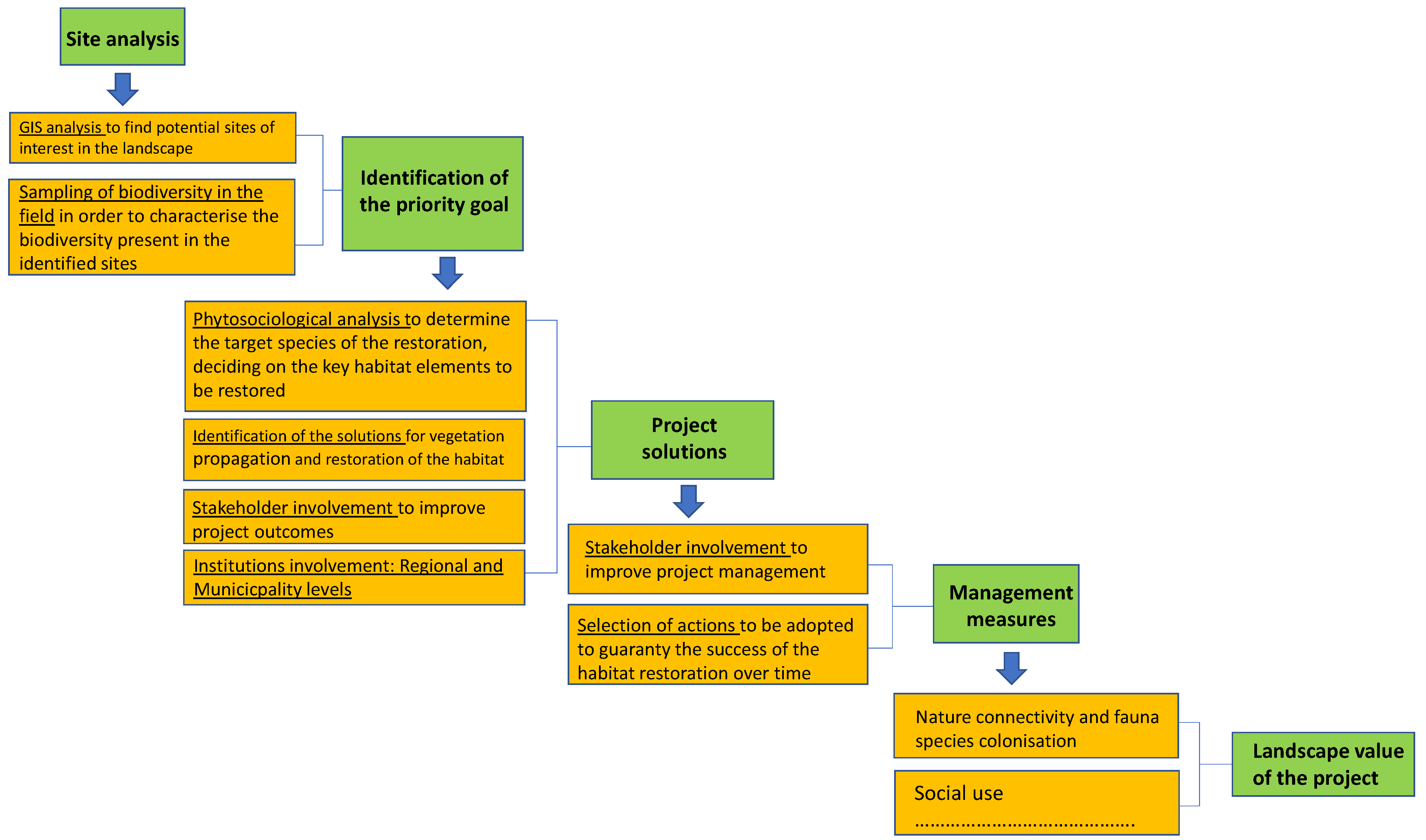
In the light of these considerations, habitat restoration projects cannot be based on mere permutations of indices but on the integration of knowledge, institutions, and stakeholders to ensure the right feedback concerning a range of aspects such as microclimate, habitat connectivity, food resources, predation risk, human disturbance, and others [
40,
41,
42].
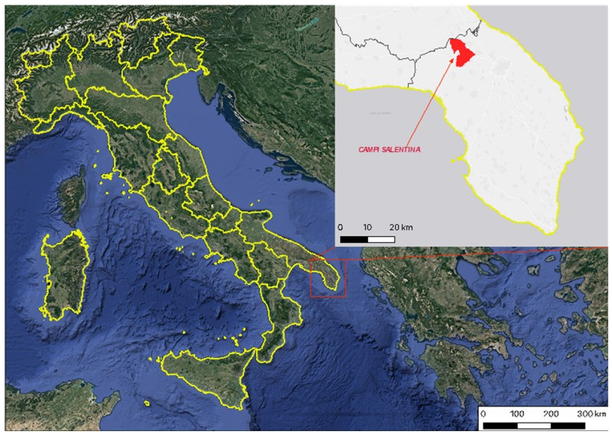
In this paper, starting from a case study, we presented an approach applied to habitat restoration in the Social-Ecological System of the municipality of Campi Salentina, in the Puglia region in Southern Italy. In the developed approach, importance is given to the way of observing and analysing biodiversity. Attention is paid to the capacity to discover and valorise the “Biodiversity Heritage Relicts” found in landscape that in other ways can be definitively lost in time.
The project focused on an intermittent watercourse called the “Lacrima”, seeking to restore a habitat that had never been surveyed, containing patches of vegetation attributable to 92A0 “Salix alba and Populus alba galleries” in consideration of the biotic and abiotic components that characterised the area.
Furthermore, in the context of the public funding received, we reported an analysis of the relevant administrative issues that have affected the development of the project.
3. Results
3.1. Site Analysis
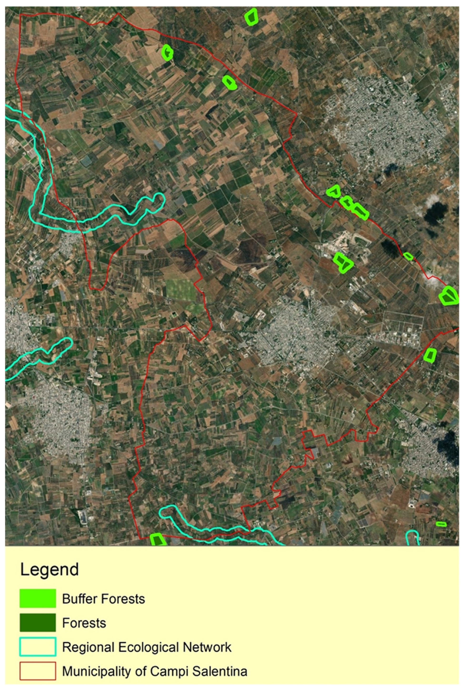
The GIS analysis highlighted four forest areas characterised by the presence of
Quercus ilex L., which is the potential natural vegetation in the Salento, widespread in other sites. After that, aerial orthophotos were analysed to find areas of potential interest that were not highlighted by the previously acquired information. Along the Lacrima River, which is an element of ecological interest for the Landscape Plan of the Puglia Region, this technique highlighted a small and unrecorded vegetation patch, not cited in the Landscape Plan or any other biodiversity study or plan (
Figure 3).
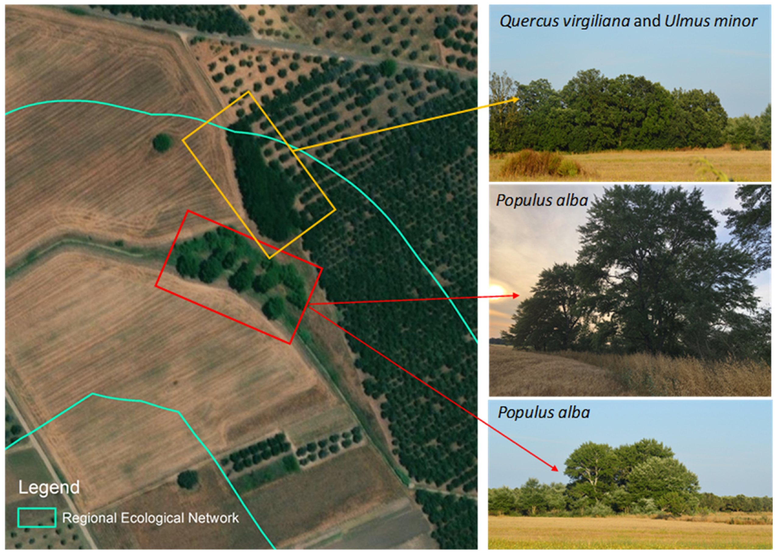
To explore the vegetation along the Lacrima River, a botanical survey was conducted to characterise its flora and vegetation. During the sampling, two patches of hygrophilous vegetation were found (
Figure 4).
The patches are characterised by the presence of
Populion albae Br.-Bl. ex Tchou 1948 consisting of specimens of,
Populus alba L.,
Populus tremula L.,
Ulmus minor Mill. and occasionally
Quercus virgiliana Ten. These represent unique testimony and evidence of past mature riparian habitat in the Province of Lecce (
Table 1).
The presence of this habitat, which is typical of rural areas with a good natural water supply, is consistent with the historical map, which shows the presence of a natural vegetations in 1800 in addition to the Lacrima River, how showed by the Plate from the Geographical Atlas of the Kingdom of Naples in the period 1788–1822 by Antonio Rizzi-Zannoni [
57].
Therefore, this nucleus of vegetation might correspond to a BHR of the riparian habitat that is unique in the Province of Lecce and has never been detected before. It is located in the agricultural landscape pattern characterised mainly by arable lands, olive groves, and vineyards (
Table 2) (
Figure 4).
3.2. Identification of the Priority Goals of the Restoration Project
In this area, although only seven adult plants were discovered, numerous young plants and many seedlings were found, demonstrating the suitability of the environmental conditions for the development of this phytocenosis. Indeed, they are stable cenoses until the hydrological conditions of the stations on which they develop change. The aim of the habitat restoration project was to focus on recovering the damaged habitat, starting from the elements already partially present in accordance with the scope of the call for project proposals. This involves: strengthening and functioning of the connection function of ecological corridors in the landscape, contrasting the processes of fragmentation and degradation of the biodiversity, and increasing ecological functionality and regional biodiversity levels.
Therefore, the restored vegetation proposed in this project will help to develop and expand the habitats cited in Directive 92/43/EEC, Annex I, 92A0—“
Salix alba and Populus alba galleries” which have been reduced to a fraction of their former extent [
37].
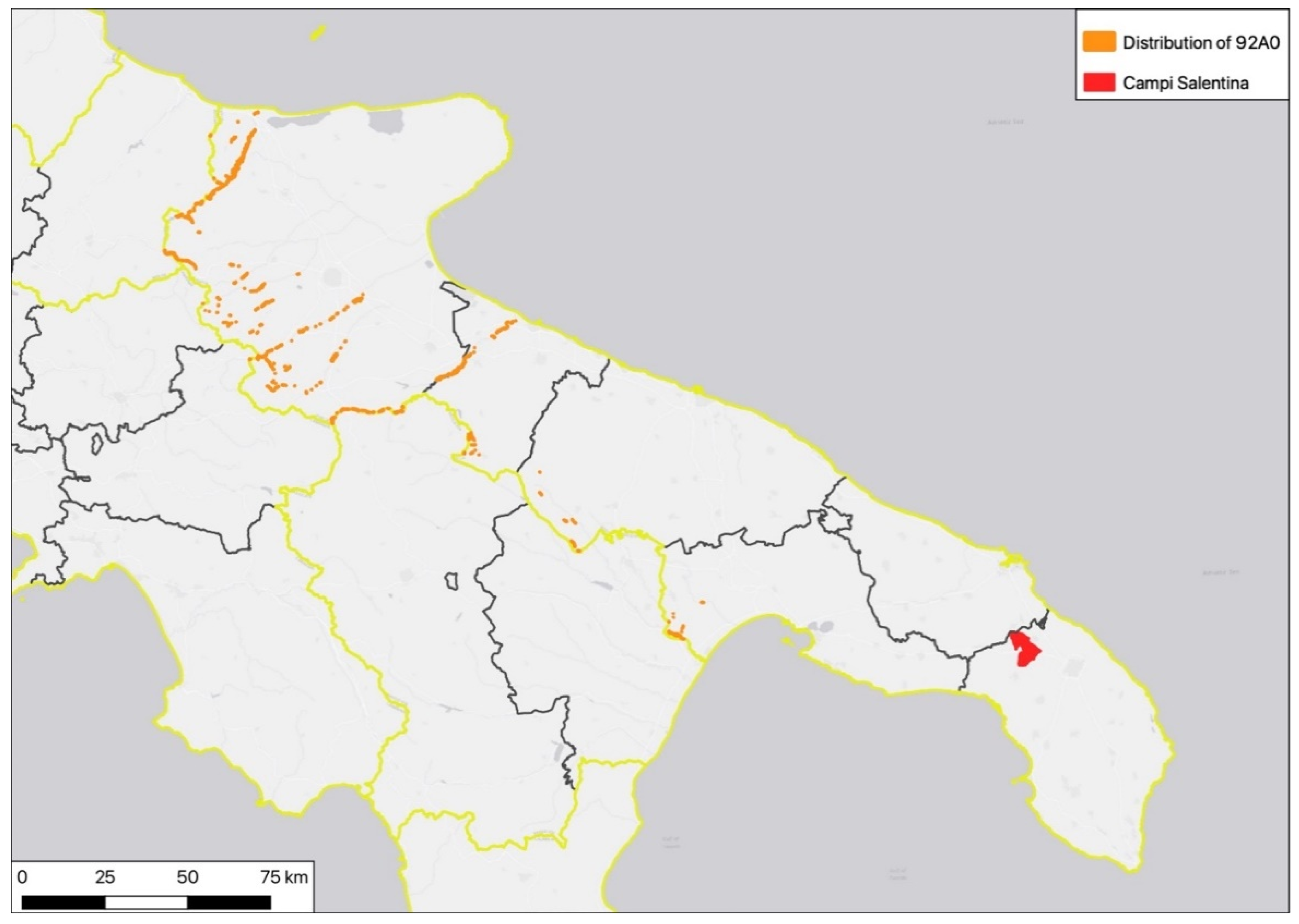
This habitat is widespread in Italy, but on a regional scale, being mainly concentrated in the north and not reported in the south of Puglia, including the Province of Lecce (
Figure 5). Therefore, the project will enhance and enrich biodiversity in southern Puglia by creating natural patches that ensure conservation and ecological enhancement in an otherwise purely agricultural landscape.
3.3. Project Solutions
In this project, the “biodiversity heritage relict” was amplified and enhanced by including botanically compatible species typical of this area.
By introducing plant elements and further consolidating the embankments, over time, the restoration measures will favour the expansion of the existing spontaneous vegetation, which is typical of natural ecosystems in which periods of considerable water flow alternate with drier periods.
An important aspect of the project was the budget, which was €1.3 million including administrative costs. Therefore, a key aim of the project was to eliminate the sources of negative pressure acting on the vegetation which can lead to its disappearance as a result of the contextual expansion of the agroecosystems. In addition, there was an attempt to develop institutional strategies that would guarantee the management of the habitat over time and encourage social and cultural initiatives.
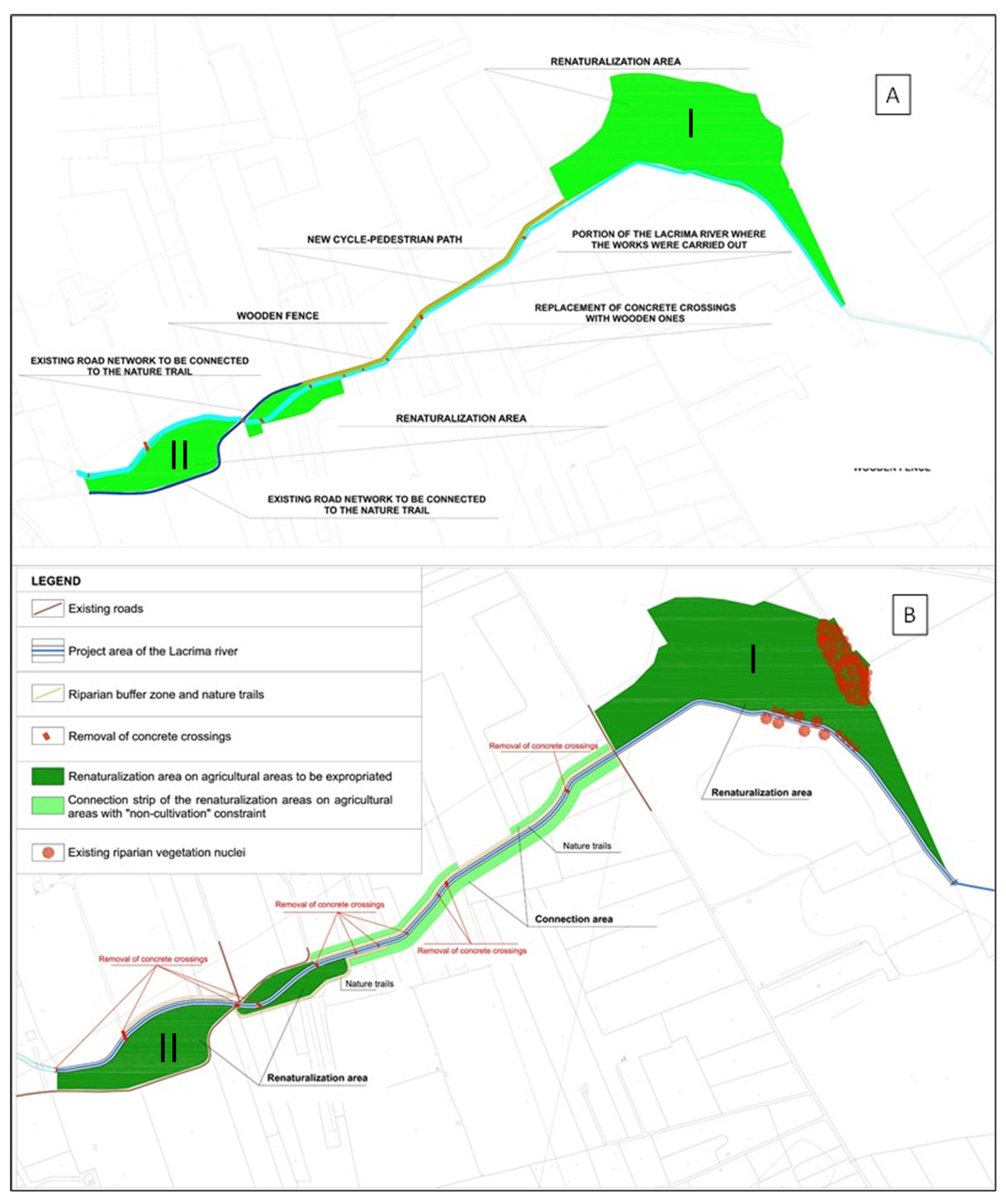
Considering the amount allocated for the restoration project, the initial phase of the project planned to create two groups of vegetation with arboreal species located in the initial and final part of the project area and to perform recovery measures on the banks of the Lacrima River, removing ruderal vegetation and sowing grassland vegetation such as
Paspalum distichum L. Along the river, a pathway for river maintenance was planned and the accessibility of the community in the area was increased (
Figure 6A).
Thanks to the involvement of Puglia Regional Administration and the local landowner, it was possible to integrate the project with a strip of vegetation along the two banks of the river. In addition, the Municipality of Campi Salentina held meetings with the owner that enabled this vegetation to be introduced without increasing the costs of land acquisition.
Therefore, the final project includes two arboreal-shrubby (the area I is about 4 ha, and the area II is about 1 ha) patches hosting riparian forest habitat in two specific places along the river that will be connected by herbaceous and shrubby vegetation along the banks (
Figure 6B). The total surface of new vegetation development is 3.5 ha (excluding the vegetation already present) with 5600 new plants introduced (excluding the replacement of dead or unrooted plants).
Great importance was given to the choice of plant species to be used for the restoration of riparian habitats and the enhancement of the specific vegetation forming these natural habitats. By means of a phytosociological study and a careful analysis of the vegetation present on the site and in the neighbouring areas, a list of species suitable for the intended purpose was drawn up. Phytosociology was used to analyse the relationship in terms of quantity and coverage between the various potential species of the association and to gather information on the plants to be included in the restoration. The following tree-shrub species were used for the riparian forest: Populus alba, Ulmus minor, that characterized the 20% of the vegetation planted in the proximity of the river side, Quercus virgiliana, Fraxinus angustifolia subsp. oxycarpa (M. Bieb. ex Willd.) Franco and Rocha Afonso, Crataegus monogyna Jacq., Ligustrum vulgare L., Sambucus nigra L. and Vitex agnus-castus L., while for the garrigue, maquis and woodland, Quercus ilex L., Pistacia lentiscus L., Smilax aspera L., Lonicera implexa Aiton, Rosa sempervirens L., Phlomis fruticosa L. and Cistus sp. pl. were planted. Unfortunately, the current restrictions designed to curb the spread of the Xylella fastidiosa bacterium in the Salento prevented the planting of other Mediterranean scrub and garrigue species.
In
Table 3, the frequency (quantity) of each species used for riparian forest and Mediterranean scrub/garrigue are reported.
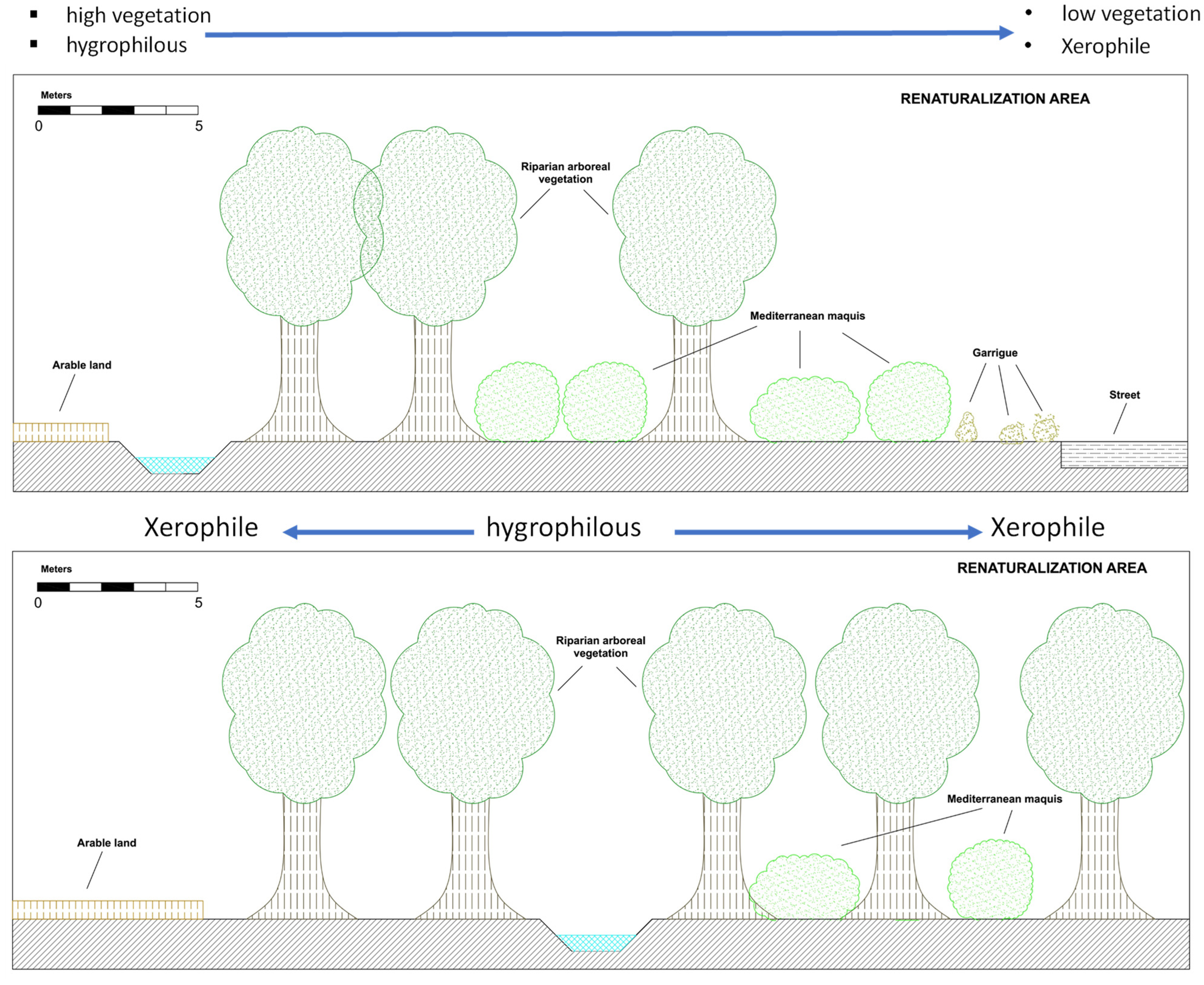
The planting of the vegetation sought to achieve seriation similar to the natural habitat, particularly concerning the
Salix alba and Populus alba galleries. In this regard, the intention was to create a gradual transition from hygrophilous plants (near the channel) to increasingly smaller xerophilous species (scrub and garrigue) towards the surrounding agricultural land (
Figure 7). To simulate a natural ecosystem, the planting was performed randomly, with no geometrical shape or pattern.
The perceptual value of the landscape was increased, since all the detractors were eliminated. These included walkways and concrete elements that were replaced with structures made of wood or other natural materials that were conducive to a “beautiful landscape”.
Vegetation development in the landscape is the result of the interaction of genetic factors and environmental conditions [
58]. Therefore, seeds and cuttings of local ecotypes were used as propagation material to preserve genetic fitness [
25]. For
Populus alba,
Quercus virgiliana and
Ulmus minor, propagation material was collected from the biodiversity heritage relict itself. This served to avoid genetic contamination caused by alien species and ecotypes from different ecological contexts and to ensure that the introduced vegetation was already adapted to the natural environment of the project. This helps avoid introducing ecotypes to the environment that are not from Puglia, which might hybridise with indigenous ecotypes, causing extraneous genes to flow into the local populations. Such genes risk altering the characteristics of the local flora, selected by the area’s distinctive environmental conditions, which is in perfect harmony with the climate and able to react in specific ways to regional environmental stressors typical of the Salento [
25].
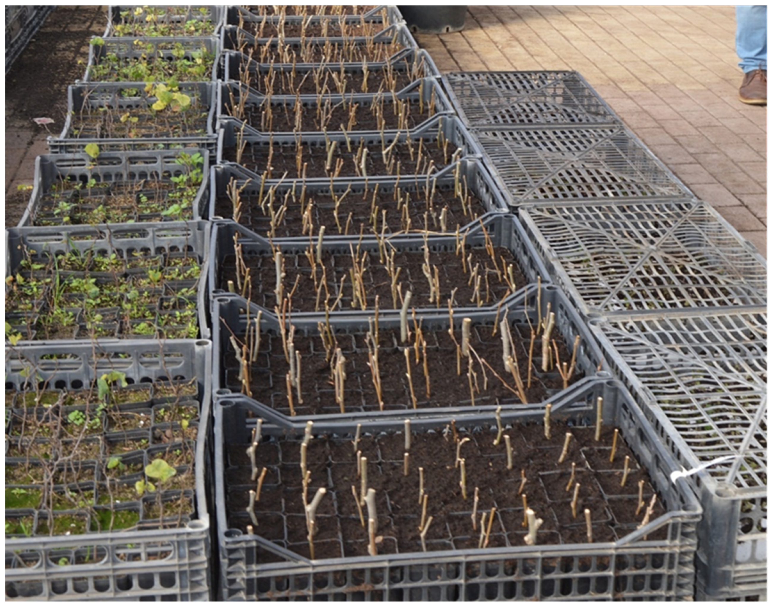
It is of primary importance that the plant material is gathered and selected from autochthonous germplasm by skilled personnel who have expert knowledge of when to harvest the seeds and/or cuttings, and the most reliable techniques for the harvest, storage, and multiplication of the propagation material. With this aim, portions of plants were collected on site to be used as cuttings (
Figure 8).
3.4. Management of the Habitat Restoration and Stakeholder Involvement
The management of the project over time is the responsibility of the Municipality of Campi Salentina, which will guarantee the success of the project and its ongoing maintenance. The project in question does not require significant economic resources for its management as it uses species that are adapted to the local climate. Indeed, only the first three or four years are critical, as it is necessary in this period to carry out emergency summer irrigation for the planted areas in order to favour the rooting of plants. Therefore, during the initial phase of the project, the municipality of Campi Salentina has planned irrigation activities to guarantee recovery of the vegetation from water stress and if necessary to remove and replace dead and unrooted plants. After the first three to four years, the vegetation should be self-sustaining and fully integrated with the newly formed habitat. The use of local genetic material will help to support the success of the vegetation’s development because it will be adapted to the environmental context of the project.
In the tender for the awarding of the contract for the works, the municipality included the condition that the company planting the vegetation must guarantee the replanting of at least 20% of the dead and unrooted plants without additional costs for the municipality.
In Social Ecological Systems, another important factor in the success of ecological restoration projects is the involvement of the owners of the affected land. This was essential to finding an agreement for acquisition areas affected by the project and gaining the understanding and involvement of the landowners who undertake agricultural activities at the edge of the project area and manage the vegetation that has been introduced. Specifically, the municipality of Campi Salentina is seeking to develop a management model for the areas of interest in partnership with landowners, who will hopefully agree to take care of the maintenance of the planted vegetation on the basis of appropriate incentives. This should result in lower municipal expenditure on management, greater protection of the area from degradation and vandalism and greater acceptance of the measures on the part of stakeholders. Indeed, the intention was not to impose the measures but to develop the project in agreement with the community that it directly concerns, specifically the landowners.
The municipality launched a direct involvement campaign by sending out an information letter and holding a meeting with the landowners. However, this has not yet produced the desired results, partly because of the large number of landowners involved. Indeed, the project site, which covers an area of about 5 hectares, is divided into 40 individual land parcels belonging to about 250 registered owners [
59,
60]. This strong fragmentation of ownership is aggravated by the fact that many owners do not reside in the municipality of interest but in completely different regions, making their involvement and interest even more problematic. The fact that many plots of land have multiple owners can create internal conflicts among the owners themselves regarding the choice of how to use the land.
The project schedule made it impossible to further develop this strategy and involve more stakeholders. In the end, a partial result was achieved, whereby some secondary areas were planted without having to expropriate them.
Moreover, the format of the project did not include the possibility to developed actions after the realization of the projects like the monitoring restoration result. In any case, the municipality will carry out the monitoring of the area to detect dead and unrooted plants the substitutions of which need to be organised. Perhaps, after 10 years, when the plants have more high structure and the habitat introduced are more structured, it will be possible to carry out the analysis of the social and cultural perception of the project to understand how to continue the landscape restoration project valorisations. However, a website was developed to sponsor the project in the community and where it will be possible to highlight new actions or social events connected with the knowledge of the project.
3.5. Ecosystem Services Impacts
The habitat restoration project can have a positive impact in terms of ecosystem services because it will act on various ecological components passing from arable lands to forest riparian habitat (
Table 4).
The relevance of regulation functions is limited in consideration of the extensions of the habitat restoration. Instead, the Habitat functions, Information functions and Carrier functions can have high relevance independently from the dimension of the area restored. These habitats will constitute reserves of biodiversity within an agricultural matrix, where autochthonous and nesting species of birds, reptiles, and amphibians typical of riparian habitats will find refuge. Furthermore, these habitats will also be a source of biodiversity because plants such as
Quercus virgiliana will be able to continue to propagate, guaranteeing both the sustenance and regeneration of the forest over time and the spread of coverage to neighbouring areas where, in conditions of non-human disturbance, they can develop other small, wooded areas. Furthermore, these wooded areas and new anthropic elements introduced to replace the old types will constitute hotspots of natural vegetation in a strongly anthropized matrix, providing a series of natural “stepping-stones” for the transit and refuge of fauna [
64,
65] (
Figure 9).
Using birds as ecological indicators, it can be said that a successful intervention will favour the colonisation of the area by at least three species. The first is
Sylvia atricapilla, a forest species that needs, at least in the reproductive period, areas with arboreal elements and shrub species forming a rich undergrowth. The second species is
Luscinia megarhynchos, which is closely linked to cool and humid woodlands with abundant undergrowth. The third species is
Remiz pendulinus, typical of humid freshwater environments, which nests on tree branches suspended over the water [
66] (
Figure 10).
In these terms, although it is not the main purpose of this project, the measures can be framed in terms of “Green infrastructure”, since they favour the creation of a network that has a positive impact not only on biodiversity in the context of the municipality of Campi Salentina, but on the entire landscape context to which it belongs, becoming ecologically part of the Natura 2000 network. Indeed, the EU defines green infrastructure as “a network of natural and semi-natural areas planned at a strategic level with other environmental elements, designed and managed in such a way as to provide a broad spectrum of ecosystem services” [
67].
The existing paths along the channel were improved in order to enable them to be used for the maintenance of the vegetation and the river. However, to support the cultural and social functions of the site, they were designed and structured in such a way as to guarantee safe use by the population, even those with walking difficulties. This should make it possible to develop recreational activities, in harmony with the natural assets, that were not explicitly included in the ecological restoration project. The increase of the community mobility in the project area for recreational activities is an important element to improve the awareness and knowledge of the ecological value of the habitat restored and its value perceptions for human well-being. Indeed, the possibility of an individual to perceive an area of social value and obtain benefits depends on the experience that an individual has in moving within the space, creating occasions for social interactions and enjoyable time [
55,
68,
69]. Given the context of reference, the project could lead to the creation of a “Peri-urban Regional Park” which can be used for educational purposes, but also for scientific research, given the rarity of the restored vegetation in the Salento. The main result of the project lies in its ability to restore community habitats in a purely agricultural context that can be enjoyed by the public by means of a simple walk or bicycle ride. People will be able to immerse themselves in a natural oasis in a purely agricultural context without realising it, during a walk or bike ride that may start several kilometres away.
3.6. Administrative and Institutional Feedback on the Project Development
The project was implemented with public funding provided by the regional administration that established the budget, work schedule and reporting deadlines, as well as providing for specific measures such as the expropriation of land on which to implement the works and other initiatives, in accordance with rules indicated by the European Union for the use of international funds (
Figure 10).
An important aspect that emerged from the administrative analysis of the project is the inconsistency between the timing of the call for project proposals and the project activities. Therefore, this led to the development of a work schedule designed to comply with the need to report expenses by a set date. This risked being incompatible with the time required for the preparation of the plant material (cuttings and seeds) and the relative planting (preferably to be performed in the periods of vegetative rest from October to March). In this regard, the municipality brought forward the preparation of plant material from autochthonous vegetation with cuttings by starting this activity independently of the financing of the project, before the allocation of financial resources and the start date of the work.
Another important aspect is the management of the project in the first few years, when the vegetation needs more support for development, especially in the summer months due to low rainfall. The funding did not allow for the continuation of the activities beyond the period of time allotted for maintenance. This meant that was impossible to fund maintenance measures that would guarantee the success of the project, such as emergency irrigation, in the first three years after the end of the works. This potentially represents a problem for public administrations that start ecological restoration projects, since they may not have adequate resources to support management and maintenance in the most delicate years for the development of the vegetation. It would have been appropriate to set aside a part of the budget for the first three years after the end of the works, in order to provide emergency irrigation or implement other measures to foster the resilience of the restoration in an integrated way with the available funds.
The last aspect, but not the least important, was to establish tender procedures for awarding contracts for the execution of the ecological restoration measures. The structure and methods adopted for public tenders can have important implications for the introduction of further design ideas, enabling those who carry out the work to improve the basic project with additional measures that were not initially envisaged, provided that that they do not go beyond the maximum budget.
In this case, the municipality chose to issue a tender in which less importance was given to the cost of the works relative to the funding provided by Puglia Regional Administration and more weight was given to the possibility of introducing improvements during the project’s implementation.
This prompted companies to introduce new elements consistent with the purpose of the project that were not considered in the initial draft of the project. The tender left open the possibility of integrating new knowledge and experiences in the design phase, which in the first draft of the project may have been limited by the knowledge of the designers, and therefore to maximise the result within the allocated budget.
One measure introduced by the company that won the tender was the development of a website to explain the ecological restoration. This can be seen as an intangible asset serving to increase the visibility of the project and inform the public about the proposed measures and their ecological, social, and cultural value in the landscape.
4. Discussion
Fragmentation is caused overwhelmingly by anthropic pressure, which leads to a progressive loss of surface area, biodiversity, and habitat. Therefore, it is important to combine field analysis and local expert knowledge [
5,
10,
11].
The biodiversity heritage relict considered in this study is not an isolated case limited to the municipality of Campi Salentina. Indeed, other examples are scattered around the province of Lecce and the Puglia region, which is characterised by extensive agricultural landscapes. Forest habitats are mainly confined to patches of less than 1 hectare lying outside protected areas. While there are many policies to preserve natural habitats in protected areas it is necessary to develop strategies to safeguard the unreported habitats lying outside them, and the Lacrima River project can be considered an explorative example. Therefore, the methodology proposed in this study could represent an effective combination of technology, knowledge acquired in the field, and social and institutional involvement that can support habitat restoration policies and projects designed to improve biodiversity in the Social-Ecological System [
3,
8,
70,
71].
Certain issues arising from the project, such as the schedule for the activities and budgetary reporting, may yield insights that are useful for improving international European rules governing the funding of restoration projects by enabling them to take account of a broader range of management scenarios. A related concern is that the result of the restoration project cannot be assessed at the time of its completion, because the vegetation needs time to develop and is strongly conditioned by human and environmental conditions. Therefore, ecological restoration projects need to be monitored over time, with the possibility of further intervention at least in the first 3 years. Furthermore, the schedule for project implementation and budgetary reporting must be adapted to the specific needs of the vegetation and not the other way around, because the objective of these projects is not merely compliance with accounting rules but the ecological recovery of the landscape.
The innovative aspect of the project proposal entitled “The Unknown Past And Aware Future Of The Landscape Mosaic Of the Lacrima River: A Project For The Ecological Restoration Of The Riparian Forest” lay in the restoration of a habitat, starting from a small relict of vegetation testifying to its more substantial presence in the past and thus to what “might have been” in the absence of agricultural activities and other anthropogenic pressures. In short, a habitat of community importance, currently rare in the context of the Salento, has been reconstituted.
This project is therefore not limited to enhancing habitats already present and recorded, as often happens in protected areas, but aims to enhance, by means of specific measures, habitats that are currently not recorded but have intrinsically high conservation value and that represent “biodiversity heritage relict” in the landscape.
Therefore, this project adopted an approach based on expertise and the ability to interpret the ecological aspects in the landscape and not on the use of ecological indices. It may be that on the basis of vegetation indices alone, this area would not have been considered for ecological restoration because of its small size and low number of species. However, the particular species found along the river have great significance in terms of biodiversity conservation (Habitats Directive), and the importance of the project thus goes beyond the simple interpretation of numbers. Naturally, this is particularly suitable for SESs where the remaining habitat has been heavily compromised by human actions over time. In contrast, this approach may not be appropriate in natural contexts where the selection of vegetation is mainly determined by disturbance unrelated to anthropic activity, and the reduction of the habitat is the result of the natural evolution of the landscape. In this case, it might not make sense to intervene in a “biodiversity heritage relict” because it would distort the natural evolution of the system and have poor results, meaning that any economic expense would be wasted.
The main aspect that emerges from the implementation of restoration ecology projects in a highly anthropized context concerns the relationship between social and environment factors, since they are of equal importance and are to be understood as integral parts of a single system in dynamic equilibrium. In an ecological restoration project, the tension between social and natural components needs to be replaced by a holistic vision characterised by the co-evolution of society and the environment, understood as strictly interdependent systems, in continuous dynamic interaction and subject to multiple changes, due to the feedback mechanisms existing between them. Landscape transformation processes must therefore promote social inclusion and the development of knowledge. Such processes and knowledge must not be the exclusive preserve of the “experts” but must involve all interested parties who live or operate in some way in the territory. The municipality of Campi Salentina has sought to develop a management strategy for the areas affected by the project in collaboration with certain landowners who are expected take care of the maintenance of the planted vegetation. However, this highlights the need to develop inclusive regional planning strategies that can facilitate and encourage ecological restoration projects. This may be difficult to implement organically in the design phase of the restoration project, although it should be more effective in the development phase.
A bibliographic analysis was carried out to verify the existence of similar interventions, with little evidence. Although it is not possible to exclude the existence of similar projects in other contexts not referenced in the scientific literature, surely this design hypothesis is among the first such projects in Italy to reconcile past landscape vegetation, of which few traces remain today and which have not been well publicised, with the future evolution of the social-ecological landscape. Indeed, this project was included as an example of the good national practices and good projects in the national annual report of land-use loss [
72].
5. Conclusions
This study provided a point of reference and reflection for other habitat restoration projects in strong damaged habitat, since creating and sharing experiences increases the ability to develop other projects through a learning-by-doing approach. The approach adopted, the experience gained, and the solutions developed in the course of the project produce knowledge that can form the starting point for new initiatives.
In a habitat restoration project conducted within an SES, an additional goal is to create the ecological, social, and cultural conditions that enable further opportunities to be exploited independently of the primary purpose of the project. This does not require a precise design but rather flexibility, making it possible to adapt to requests that may arise by chance and without planning. This aspect involves the project designers, who are aware that there are aspects that cannot be developed in the project directly for economic reasons or because they do not fall within the scope of the project. Therefore, when designing a habitat restoration project in an SES, the designers can leave certain questions open by creating the conditions for their development in the future. This is what was done in the Lacrima project regarding the potential use of the area for social use and institutional management in the time.
If the proposed measures are successful in recreating the desired community habitat, the site of the intervention could then be proposed as an SCI (Site of Community Importance) or be included in a network of natural areas (NATURA 2000) to improve the local conservation practices. This would be helpful for the further development of the project because it would be managed as a “Protected Area”. This could help to draw on specific forms of financing for the implementation of other initiatives that could enhance biodiversity by guaranteeing high resilience over time in terms of the socio-economic evolution of the context of reference. In this regard, an ecological restoration project in an SES must be based on institutions that value creativity and flexibility, seeing design as an experiment from which to learn and acquire new knowledge, in which participation is recognised as the key to success.


 ,
, 


