
Semi-Natural Areas on Post-Mining Brownfields as an Opportunity to Strengthen the Attractiveness of a Small Town. An Example of Radzionków in Southern Poland


Abstract
:1. Introduction
2. Research Review
- a small industrial or mining town after the loss of its function,
- inter-city competition for investments in the context of local and regional policy,
- urban shrinkage and brownfields development,
- green infrastructure.
- integration,
- multifunctionality,
- connectivity,
- multi-scale approach,
- multi-object approach [15].
3. Data and Methods
- Addition Messtischblatt sheets to the project.
- Launching the “georeference” tool.
- Shifting the map sheets to the right place (you can enlarge/reduce the map), OSM can be used as a base map, historical sheets can match.
- Saving changes and close georeference.
- Exporting the spreadsheet as a. Tiff file—now the file is georeferenced and can also be used in other GIS programs.
- Cutting sheets with the “Clip” tool to the commune border.
- Matching the cut map sheets to each other and the base map (optional raster combination).
- Superimposing the data to compare the map (CLC, UA, OSM) on the finished raster.
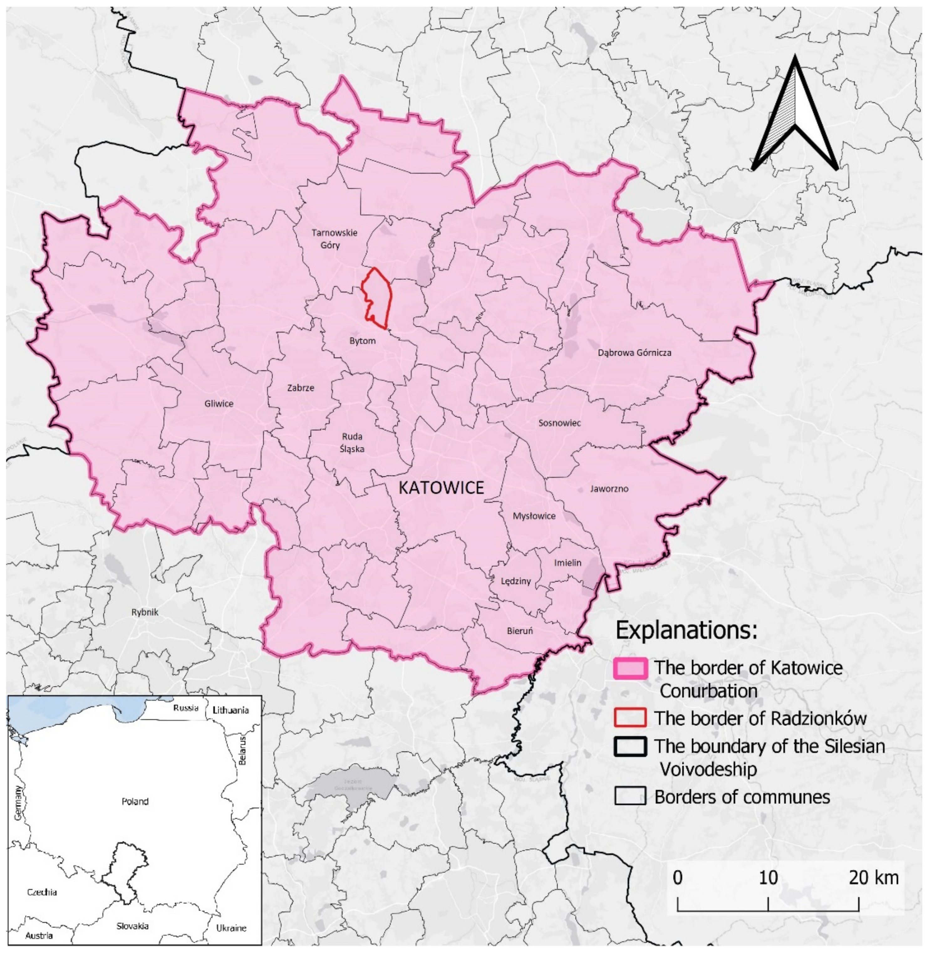
4. The Small Town of Radzionków on the Way from Industrialization to Post-Mining

| Town | Area in ha | Population in Total | Dynamics of the Population in % | ||||
|---|---|---|---|---|---|---|---|
| 2000 | 2010 | 2019 | 2000–2010 | 2010–2019 | 2000–2019 | ||
| Radzionków | 1320 | 17,533 | 17,169 | 16,873 | −2.08 | −1.72 | −3.76 |
| Bytom | 6944 | 195,807 | 181,617 | 165,263 | −7.25 | −9.00 | −15.60 |
| Piekary Śląskie | 3998 | 61,347 | 58,268 | 55,030 | −5.02 | −5.56 | −10.30 |
| Tarnowskie Góry | 8388 | 62,764 | 60,818 | 61,686 | −3.10 | 1.43 | −1.72 |

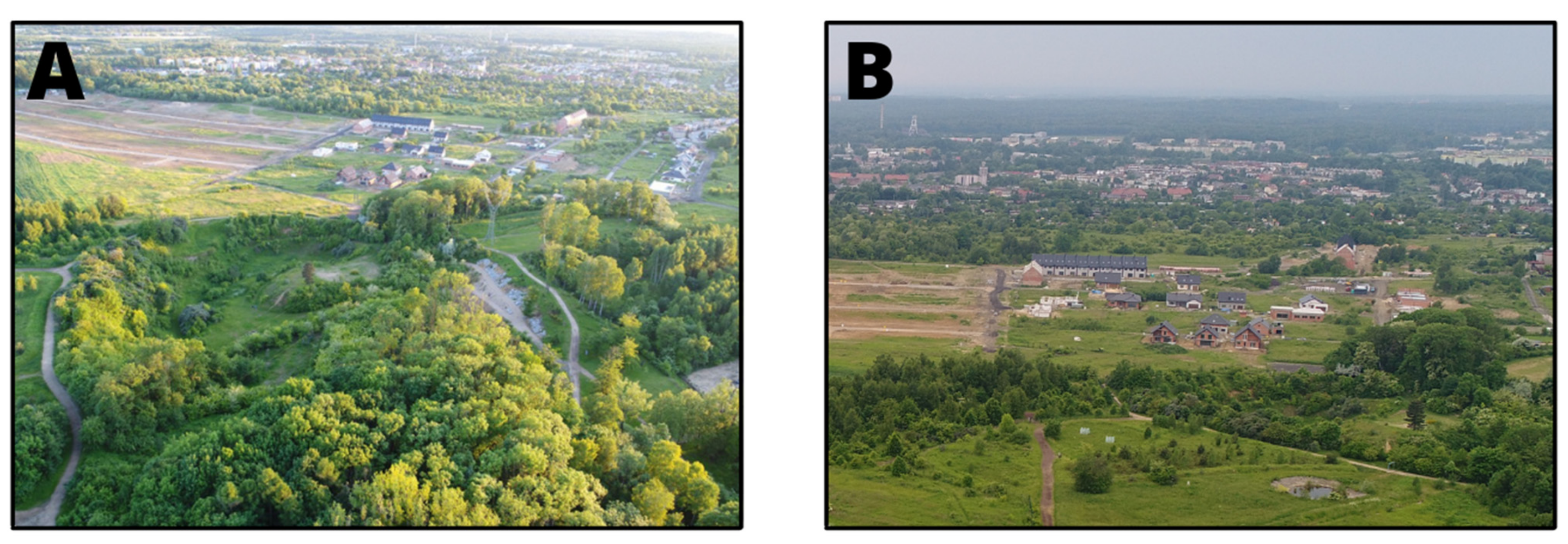
5. Directions of Development of Post-Industrial and Post-Mining Areas in Radzionków
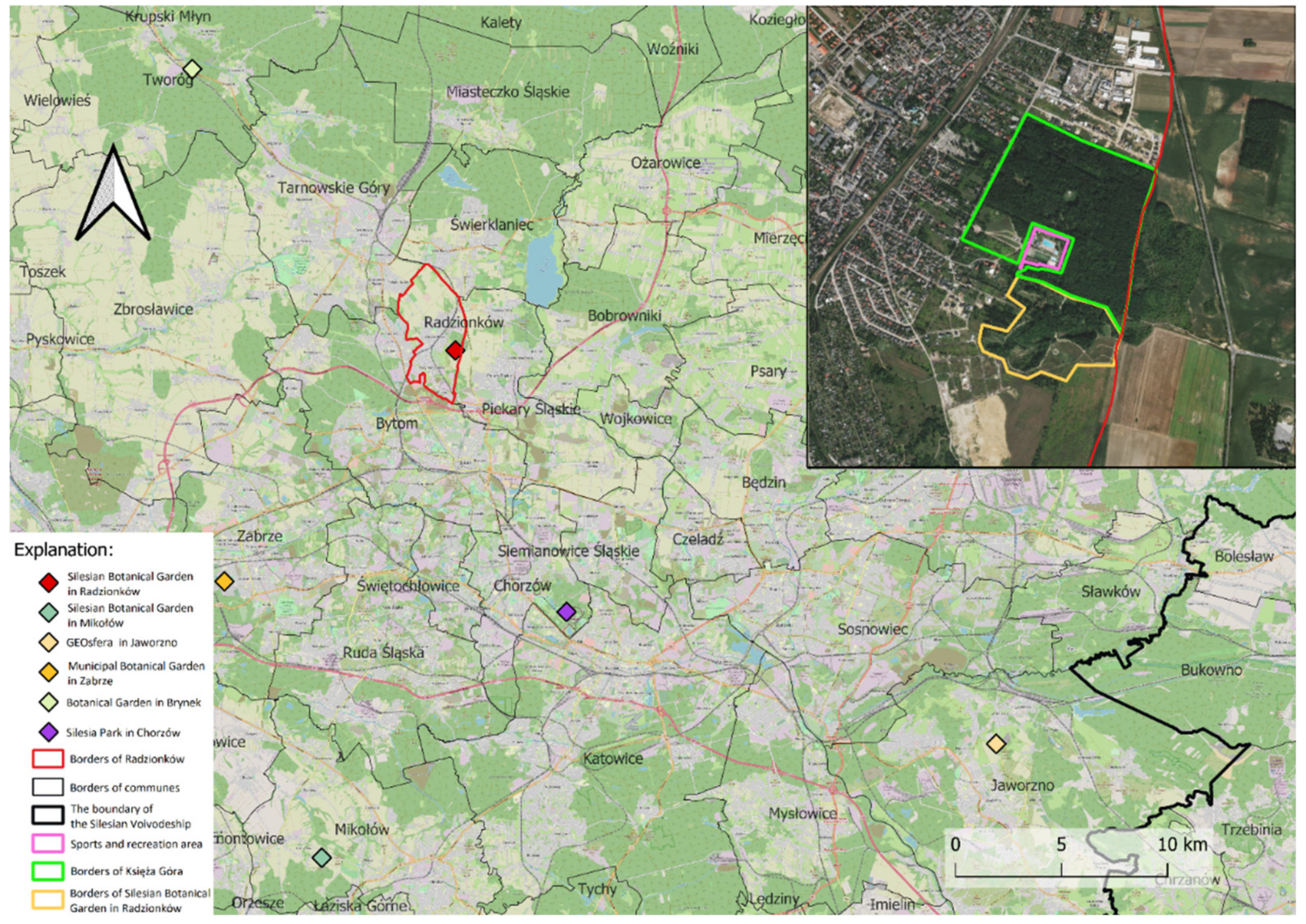
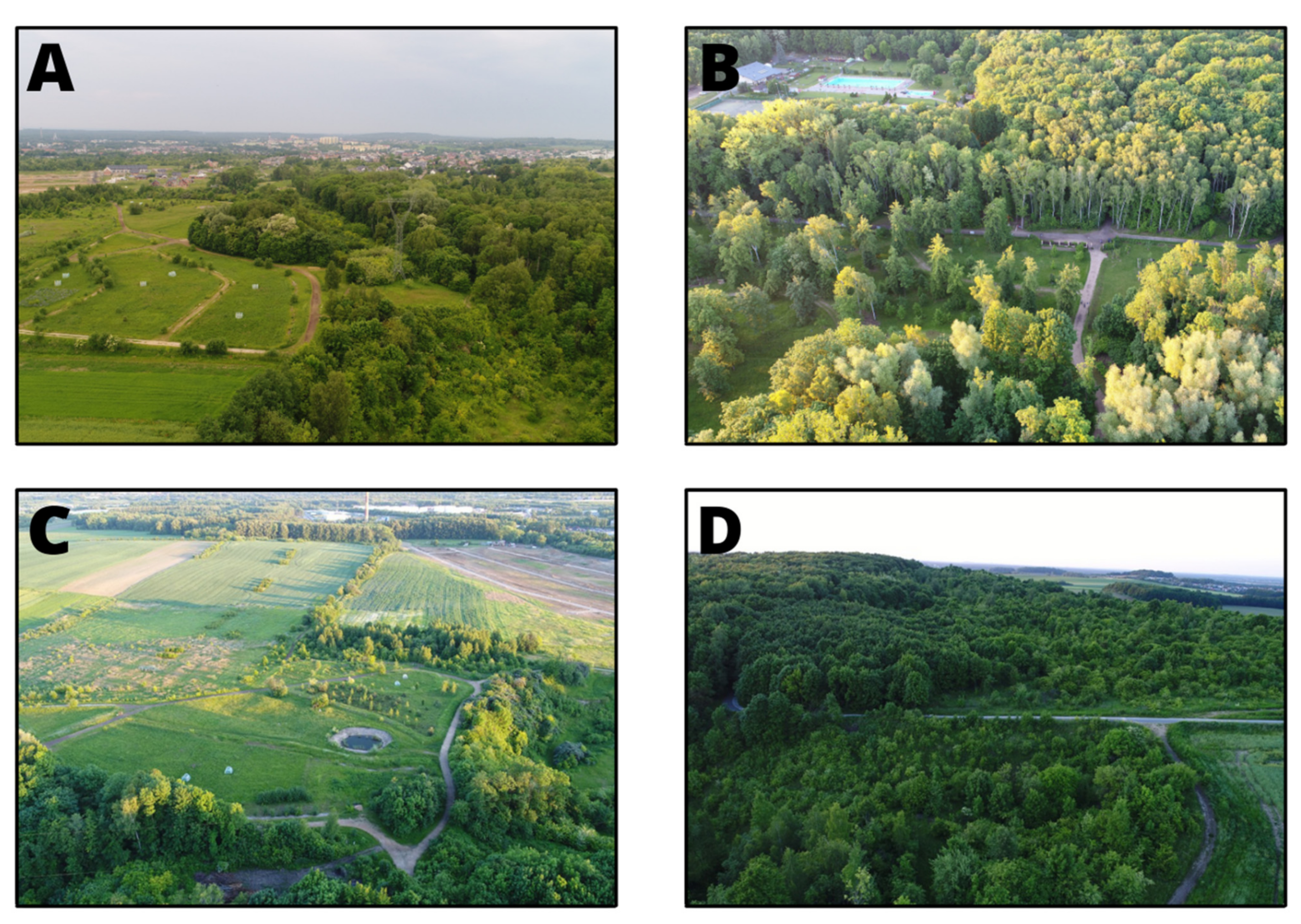
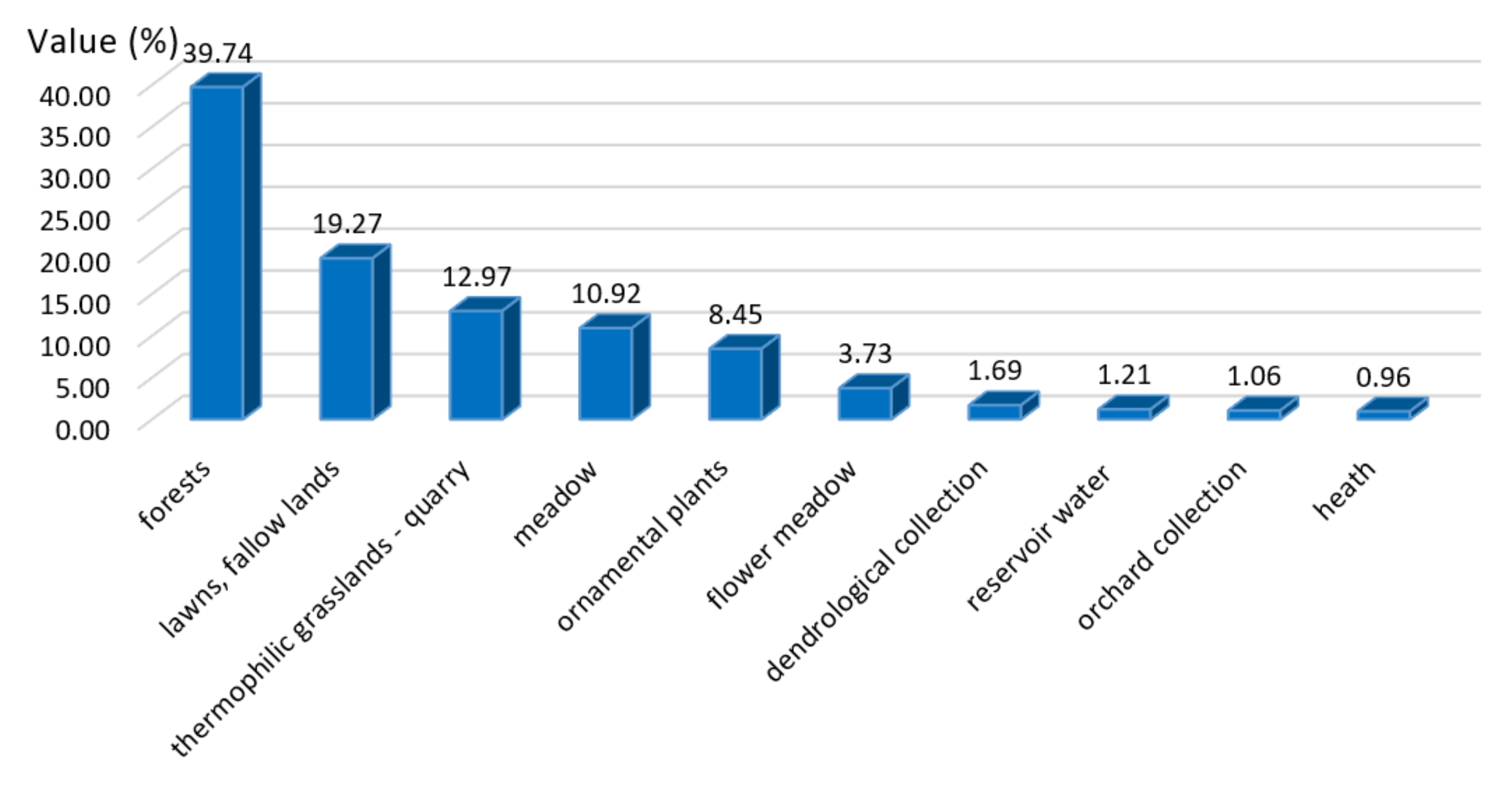
6. The Silesian Botanical Garden in Radzionków, in Comparison with Other Similar Natural Objects in the Region
- urban green infrastructure is viewed, which can be integrated with other urban infrastructures in terms of physical and functional relations (integration);
- green infrastructure planning encompasses the ecological, social, economic, abiotic/biotic, and cultural functions of green spaces; (multifunctionality);
- green infrastructure planning considers physical and functional connections between green spaces at different scales (connectivity);
- green infrastructure can be applied to initiatives at different scales, from individual parcels to the community, regional, and state-level (multi-scale approach) and
- green infrastructure includes all green and blue spaces, natural and semi-natural areas, water bodies, parks, and gardens (multi-object approach).
7. Discussion
8. Conclusions
Author Contributions
Funding
Institutional Review Board Statement
Informed Consent Statement
Data Availability Statement
Conflicts of Interest
References
- Martinez-Fernandez, C.; Wu, C.-T.; Schatz, L.K.; Taira, N.; Vargas-Hernández, J.G. The shrinking mining city: Urban dynamics and contested territory. Int. J. Urban. Reg. Res. 2012, 36, 245–260. [Google Scholar] [CrossRef] [PubMed]
- Haase, A.; Rink, D.; Grossmann, K.; Bernt, M.; Mykhnenko, V. Conceptualizing Urban Shrinkage. Environ. Plan. A Econ. Space 2014, 46, 1519–1534. [Google Scholar] [CrossRef] [Green Version]
- Batunova, E.; Gunko, M. Urban shrinkage: An unspoken challenge of spatial planning in Russian small and medium-sized cities. Eur. Plan. Stud. 2018, 26, 1580–1597. [Google Scholar] [CrossRef]
- Tong, Y.; Liu, W.; Li, C.; Zhang, J.; Ma, Z. Small towns shrinkage in the Jilin Province: A comparison between China and developed countries. PLoS ONE 2020, 15, e0231159. [Google Scholar] [CrossRef] [Green Version]
- Tong, Y.; Liu, W.; Li, C.; Zhang, J.; Ma, Z. Understanding patterns and multilevel influencing factors of small town shrinkage in Northeast China. Sustain. Cities Soc. 2021, 68, 102811. [Google Scholar] [CrossRef]
- Wiechmann, T.; Pallagst, K. Urban shrinkage in Germany and the USA: A comparison of transformation patterns and local strategies. Int. J. Urban Reg. Res. 2012, 36, 261–280. [Google Scholar] [CrossRef]
- Atkinson, R. Policies for small and medium-sized towns: European, national and local approaches. Tijdschr. Econ. Soc. Geogr. 2017, 108, 472–487. [Google Scholar] [CrossRef]
- Kantor-Pietraga, I. Does one decade of urban policy for the shrinking city make visible progress in urban re-urbanization? A case study of bytom, Poland. Sustainability 2021, 13, 4408. [Google Scholar] [CrossRef]
- Wirth, P.; Elis, V.; Müller, B.; Yamamoto, K. Peripheralisation of small towns in Germany and Japan–Dealing with economic decline and population loss. J. Rural Stud. 2016, 47, 62–75. [Google Scholar] [CrossRef]
- Lovell, S.A.; Gray, A.; Boucher, S.E. Economic marginalization and community capacity: How does industry closure in a small town affect perceptions of place? J. Rural Stud. 2018, 62, 107–115. [Google Scholar] [CrossRef]
- Mayer, H.; Knox, P. Small-town sustainability: Prospects in the second modernity. Eur. Plan. Stud. 2010, 18, 1545–1565. [Google Scholar] [CrossRef]
- Szeligova, N.; Teichmann, M.; Kuda, F. Research of the disparities in the process of revitalization of brownfields in small towns and cities. Sustainability 2021, 13, 1232. [Google Scholar] [CrossRef]
- Krzysztofik, R.; Kantor-Pietraga, I.; Kłosowski, F. Between Industrialism and Postindustrialism—The Case of Small Towns in a Large Urban Region: The Katowice Conurbation, Poland. Urban Sci. 2019, 3, 68. [Google Scholar] [CrossRef] [Green Version]
- Mell, I.C. Green Infrastructure: Concepts and planning. FORUM E-J. 2008, 8, 69–80. [Google Scholar]
- Wirth, P.; Chang, J.; Syrbe, R.U.; Wende, W.; Hu, T. Green infrastructure: A planning concept for the urban transformation of former coal-mining cities. Int. J. Coal Sci. Technol. 2018, 5, 78–91. [Google Scholar] [CrossRef] [Green Version]
- De Sousa, C.A. The greening of brownfields in American cities. J. Environ. Plan. Manag. 2004, 47, 579–600. [Google Scholar] [CrossRef]
- Chang, J.; Koetter, T. From abandoned mine land to landscape park. J. China Coal Soc. 2005, 30, 399–402. [Google Scholar]
- Siikamäki, J.; Wernstedt, K. Turning brownfields into greenspaces: Examining incentives and barriers to revitalization. J. Health Polit. Policy Law 2008, 33, 559–593. [Google Scholar] [CrossRef] [Green Version]
- Kristiánová, K.; Gécová, K.; Putrová, E. Old Industrial Sites–Conversion to Parks: Potential of Bratislava. Proc. Eng. 2016, 161, 1858–1862. [Google Scholar] [CrossRef] [Green Version]
- Rizzo, E.; Pesce, M.; Pizzol, L.; Alexandrescu, F.M.; Giubilato, E.; Critto, A.; Marcomini, A.; Bartke, S. Brownfield regeneration in Europe: Identifying stakeholder perceptions, concerns, attitudes and information needs. Land Use Policy 2015, 48, 437–453. [Google Scholar] [CrossRef]
- Tkacz, K. Rewitalizacja terenów KWB “Bełchatów” jako szansa na rozwój małych miast. Revitalization of Coal Mine Belchatow, as an opportunity for the development of small towns. Przestrz. Forma 2015, 23, 267–278. Available online: http://yadda.icm.edu.pl/baztech/element/bwmeta1.element.baztech-fab3b922-a795-4beb-80b1-6a8e290d7157 (accessed on 10 May 2021).
- Navratil, J.; Picha, K.; Martinat, S.; Nathanail, P.C.; Tureckova, K.; Holesinska, A. Resident’s preferences for urban brownfield revitalization: Insights from two Czech cities. Land Use Policy 2018, 76, 224–234. [Google Scholar] [CrossRef]
- BenDor, T.K.; Metcalf, S.S.; Paich, M. The dynamics of brownfield redevelopment. Sustainability 2011, 3, 914–936. [Google Scholar] [CrossRef] [Green Version]
- Lazzeroni, M. Industrial decline and resilience in small towns: Evidence from three European case studies. Tijdschr. Econ. Soc. Geogr. 2020, 111, 182–195. [Google Scholar] [CrossRef]
- Heder, A.; Tkocz, M. Zmiany demograficzne i funkcjonalne małych miast górniczych (na przykładzie Bierunia i Lędzin) Demographic and functional changes in small mining towns (on the example of Bieruń and Lędzin). Acta Geogr. Sil. 2011, 10, 11–20. Available online: https://core.ac.uk/download/pdf/197753213.pdf (accessed on 12 May 2021).
- Vaishar, A.; Lipovská, Z.; Št’astná, M. Small towns in post-mining regions. In Post-Mining Regions in Central Europe Problems, Potentials, Possibilities; Wirth, P., Mali, B.Č., Fischer, W., Eds.; Oekom: München, Germany, 2012; pp. 153–167. [Google Scholar]
- Marais, L.; Atkinson, D. Towards a post-mining economy in a small town: Challenges, obstacles and trends. In Proceedings of the Desert Knowledge Australia Conference, Alice Springs, Australia, 3–6 November 2006. [Google Scholar]
- Prach, K.; Řehounková, K.; Řehounek, J.; Konvalinková, P. Ecological restoration of central european mining sites: A summary of a multi-site analysis. Landsc. Res. 2011, 36, 263–268. [Google Scholar] [CrossRef]
- Adesipo, A.A.; Freese, D.; Zerbe, S.; Wiegleb, G. An approach to thresholds for evaluating post-mining site reclamation. Sustainability 2021, 13, 5618. [Google Scholar] [CrossRef]
- Marot, N.; Harfst, J. Post-mining potentials and redevelopment of former mining regions in Central Europe–Case studies from Germany and Slovenia. Acta Geogr. Slov. 2012, 52, 99–119. [Google Scholar] [CrossRef] [Green Version]
- Kaźmierczak, U.; Strzałkowski, P.; Lorenc, M.W.; Szumska, E.; Sánchez, A.A.P.; Baker, K.A.C. Post-mining Remnants and Revitalization. Geoheritage 2019, 11, 2025–2044. [Google Scholar] [CrossRef] [Green Version]
- Łacny, Z.; Kowalska, N.; Tran, L. The Possibilities of the Revitalisation of Post-Mining Areas–the Polish and Vietnamese Examples. Inż. Miner. 2019, 13. [Google Scholar] [CrossRef]
- Krzysztofik, R.; Runge, J.; Kantor-Pietraga, I. Paths of Environmental and Economic Reclamation: The Case of Post-Mining Brownfields. Pol. J. Environ. Stud. 2012, 21, 219–223. Available online: http://www.pjoes.com/Paths-of-Environmental-and-Economic-r-nReclamation-the-Case-of-Post-Mining-Brownfields,88745,0,2.html (accessed on 12 May 2021).
- Görmar, F.; Harfst, J. Path renewal or path dependence? The role of industrial culture in regional restructuring. Urban Sci. 2019, 3, 106. [Google Scholar] [CrossRef] [Green Version]
- Boros, L.; Martyin, Z.; Pál, V. Industrial tourism–trends and opportunities. Forum Geogr. 2013, 12, 108–114. [Google Scholar] [CrossRef]
- Syrbe, R.U. Recultivation and sustainable development of post-mining landscapes. In Legislation, Technology and Practice of Mine Land Reclamation; Hu, Z.Q., Ed.; CRC Press: London, UK, 2015; pp. 489–492. [Google Scholar]
- Chang, J.; Feng, S. Strategies on redevelopment of mining city industrial wasteland. Urban. Dev. Stud. 2008, 2, 54–57. [Google Scholar]
- Konecka-Szydłowska, B. Szanse i zagrożenia rozwoju nowo utworzonych małych miast. Stud. Miej. 2020, 7, 123–134. Available online: https://czasopisma.uni.opole.pl/index.php/sm/article/view/2652 (accessed on 13 May 2021).
- Loures, L. Post-industrial landscapes as drivers for urban redevelopment: Public versus expert perspectives towards the benefits and barriers of the reuse of post-industrial sites in urban areas. Habitat Int. 2015, 45, 72–81. [Google Scholar] [CrossRef]
- Loures, L.; Vaz, E. Exploring expert perception towards brownfield redevelopment benefits according to their typology. Habitat Int. 2018, 72, 66–76. [Google Scholar] [CrossRef]
- Courtney, P.; Errington, A. The Role of small towns in the local economy and some implications for development policy. Local Econ. 2000, 15, 280–301. [Google Scholar] [CrossRef]
- Zuzańska-Żyśko, E. Małe miasta w strefie oddziaływania ośrodków regionalnych. Small towns in the area of influence of regional centers. Biul. PAN. Kom. Przestrz. Zagospod. Kraj. 2007, 232, 62–78. [Google Scholar]
- Kwiatek-Sołtys, A. The role of small towns in the metropolitan areas. In Desafíos de Las Metropolis: Efectos Ambientales y Sociales: Tendencias Geográficas II; Santana-Juárez, M.V., Hoyos-Castrillo, G., Santana-Castańeda, G., Pineda-Jaimes, N.B., Campos-Alanís, H., Eds.; Universidad Autónoma del Estado de México: Toluca, Mexico, 2016; pp. 443–454. [Google Scholar]
- Gałka, J.; Warych-Juras, A. Suburbanization and migration in polish metropolitan areas during political transition. Acta Geogr. Slov. 2018, 58, 63–72. [Google Scholar] [CrossRef] [Green Version]
- Majewska, A.; Denis, M.; Krupowicz, W. Urbanization Chaos of suburban small cities in Poland: ‘Tetris development’. Land 2020, 9, 461. [Google Scholar] [CrossRef]
- Krzysztofik, R. (Ed.) Przemiany Demograficzne Miast Polski. Wymiar Krajowy, Regionalny i Lokalny. Demographic Changes in Polish Cities. National, Regional and Local Dimension; Instytut Rozwoju Miast i Regionów: Warszawa-Kraków, Poland, 2019. [Google Scholar]
- Wolff, M.; Wiechmann, T. Urban growth and decline: Europe’s shrinking cities in a comparative perspective 1990–2010. Eur. Urban Reg. Stud. 2018, 25, 122–139. [Google Scholar] [CrossRef]
- Pallagst, K.; Wiechmann, T.; Martinez-Fernandez, C. (Eds.) Shrinking Cities. International Perspectives and Policy Implications; Routledge: New York, NY, USA, 2013. [Google Scholar]
- Mallach, A.; Haase, A.; Hattori, K. The shrinking city in comparative perspective: Contrasting dynamics and responses to urban shrinkage. Cities 2017, 69, 102–108. [Google Scholar] [CrossRef]
- Batunova, E.; Perucca, G. Population shrinkage and economic growth in Russian regions 1998–2012. Reg. Sci. Policy Pract. 2019, 12, 595–609. [Google Scholar] [CrossRef]
- Döringer, S.; Uchiyama, Y.; Penker, M.; Kohsaka, R. A meta-analysis of shrinking cities in Europe and Japan. Towards an integrative research agenda. Eur. Plan. Stud. 2019, 28, 1693–1712. [Google Scholar] [CrossRef] [Green Version]
- Stryjakiewicz, T. (Ed.) Kurczenie się Miast w Europie Środkowo-Wschodniej. Urban. Shrinkage in Towns of the Central and East. Europe; Bogucki Wydawnictwo Naukowe: Poznań, Poland, 2014. [Google Scholar]
- Ženka, J.; Krtička, L.; Paszová, L.; Pundová, T.; Rudincová, K.; Šťastná, S.; Svetlíková, V.; Matula, J. Micro-Geographies of Information and communication technology firms in a shrinking medium-sized industrial City of Ostrava (Czechia). Land 2021, 10, 695. [Google Scholar] [CrossRef]
- Bontje, M. Facing the challenge of shrinking cities in East Germany: The case of Leipzig. GeoJournal 2004, 61, 13–21. [Google Scholar] [CrossRef]
- Bartholomae, F.; Nam, C.W.; Schoenberg, A. Urban shrinkage and resurgence in Germany. Urban Stud. 2017, 54, 2701–2718. [Google Scholar] [CrossRef]
- Nelle, A.; Großmann, K.; Haase, D.; Kabisch, S.; Rink, D.; Wolff, M. Urban shrinkage in Germany: An entangled web of conditions, debates and policies. Cities 2017, 69, 116–123. [Google Scholar] [CrossRef]
- Frantál, B.; Greer-Wootten, B.; Klusáček, P.; Krejčí, T.; Kunc, J.; Martinát, S. Exploring spatial patterns of urban brownfields regeneration: The case of Brno, Czech Republic. Cities 2015, 44, 9–18. [Google Scholar] [CrossRef]
- Mert, Y. Contribution to sustainable development: Redevelopment of post-mining brownfields. J. Clean. Prod. 2019, 240, 118212. [Google Scholar] [CrossRef]
- Pytel, S.; Sitek, S.; Chmielewska, M.; Zuzańska-Żyśko, E.; Runge, A.; Markiewicz-Patkowska, J. Transformation directions of brownfields: The case of the Górnośląsko-Zagłębiowska Metropolis. Sustainability 2021, 13, 2075. [Google Scholar] [CrossRef]
- De Groot, R.S.; Alkemade, R.; Braat, L.; Hein, L.; Willemen, L. Challenges in integrating the concept of ecosystem services and values in landscape planning, management and decision making. Ecol. Complex 2010, 7, 260–272. [Google Scholar] [CrossRef]
- Connop, S.; Vandergert, P.; Eisenberg, B.; Collier, M.J.; Nash, C.; Clough, J.; Newport, D. Renaturing cities using a regionally-focused biodiversity-led multifunctional benefits approach to urban green infrastructure. Environ. Sci. Pol. 2016, 62, 99–111. [Google Scholar] [CrossRef] [Green Version]
- Rosa, J.C.S.; Sánchez, L.E.; Morrison-Saunders, A. Getting to ‘agreed’ post-mining land use-an ecosystem services approach. Impact Assess. Proj. Apprais. 2018, 36, 220–229. [Google Scholar] [CrossRef]
- Sonter, L.J.; Ali, S.H.; Waston, J.E.M. Mining and biodiversity: Key issues and research needs in conservation science. Proc. Biol. Sci. 2018, 285, 20181926. [Google Scholar] [CrossRef]
- Łopucki, R.; Klich, D.; Kitowski, I.; Kiersztyn, A. Urban size effect on biodiversity: The need for a conceptual framework for the implementation of urban policy for small cities. Cities 2020, 98, 102590. [Google Scholar] [CrossRef]
- Almenar, J.B.; Elliot, T.; Rugani, B.; Philippe, B.; Gutierrez, T.N.; Sonnemann, G.; Geneletti, D. Nexus between nature-based solutions, ecosystem services and urban challenges. Land Use Policy 2021, 100, 104898. [Google Scholar] [CrossRef]
- Chmielewska, M.; Lamparska, M. Post-industrial tourism as a chance to develop cities in traditional industrial regions in Europe. Sociol. Românească 2011, 3, 67–75. [Google Scholar]
- Horváth, G.; Csüllög, G. The Role of Ecotourism and Geoheritage in the Spatial Development of Former Mining Regions. In Post-Mining Regions in Central Europe Problems, Potentials, Possibilities; Wirth, P., Mali, B.Č., Fischer, W., Eds.; Oekom: München, Germany, 2012; pp. 226–240. [Google Scholar]
- Pavolová, H.; Kysel’ová, K.; Bakalár, T. Brownfields as a tool for support of Destination Tourism development. Acta Geotur. 2012, 3, 26–30. Available online: https://geotur.tuke.sk/pdf/2012/n01/04_Pavolova_v3_n1.pdf (accessed on 18 May 2021).
- Gregorová, B.; Hronček, P.; Tometzová, D.; Molokáč, M.; Čech, V. Transforming brownfields as tourism destinations and their sustainability on the example of Slovakia. Sustainability 2020, 12, 10569. [Google Scholar] [CrossRef]
- Hansen, R.; Pauleit, S. From multifunctionality to multiple ecosystem services? A conceptual framework for multifunctionality in green infrastructure planning for Urban Areas. AMBIO 2014, 43, 516–529. [Google Scholar] [CrossRef] [Green Version]
- Keyes, R. Mine closures in Canada: Problems, Prospects and Policies. In Coping with Closure: An International Comparison of Mine Town Experiences; Neil, C., Tykkläinen, M., Bradbury, J., Eds.; Routledge: London, UK; New York, NY, USA, 1992; pp. 27–43. [Google Scholar]
- Smyth, R.; Mishra, V.; Qian, X. The Environment and Well-Being in Urban China. Ecol. Econ. 2008, 68, 547–555. [Google Scholar] [CrossRef] [PubMed]
- Pauleit, S.; Liu, L.; Ahern, J.; Kazmierczak, A. Multifunctional green infrastructure planning to promote ecological services in the city. In Urban Ecology: Patterns, Processes, and Applications; Niemelä, J., Ed.; Oxford University Press: New York, NY, USA, 2011; pp. 272–285. [Google Scholar]
- Doley, D.; Audet, P. What part of mining are ecosystems? Defining success for the ‘restoration’of highly disturbed landscapes. In Ecological Restoration: Global Challenges, Social Aspects and Environmental Benefits; Squires, V.R., Ed.; Nova Science: New York, NY, USA, 2016; pp. 57–88. [Google Scholar]
- Mapa Topograficzna. Topographic Map. Meßtischblatt 5579: Tarnowitz. 1940. Available online: http://amzpbig.com/maps/025_TK25/5579_Tarnowitz_mz_1940.jpg (accessed on 6 April 2021).
- Mapa Topograficzna. Topographic Map. Meßtischblatt 5579: Tarnowitz. 1943. Available online: http://amzpbig.com/maps/025_TK25/5579_Tarnowitz_1943.jpg (accessed on 6 April 2021).
- Mapa Topograficzna. Topographic Map. Meßtischblatt 5679: Beuthen. 1934. Available online: http://amzpbig.com/maps/025_TK25/5679_Beuthen_1934.jpg (accessed on 6 April 2021).
- Mapa Topograficzna. Topographic Map. Meßtischblatt 5679: Beuthen. 1943. Available online: http://amzpbig.com/maps/025_TK25/5679_Beuthen_1943.jpg (accessed on 6 April 2021).
- Corine Land Cover 2018 PL. Available online: https://clc.gios.gov.pl/index.php/clc-2018/metadane (accessed on 30 March 2021).
- Urban Atlas 2018 Copernicus Land Monitoring Service. Available online: https://land.copernicus.eu/local/urban-atlas/urban-atlas-2018 (accessed on 30 March 2021).
- Google Maps. Available online: https://www.google.pl/maps (accessed on 6 April 2021).
- OpenStreetMap. Available online: https://www.openstreetmap.org/ (accessed on 6 April 2021).
- Geoportal 2 Mapy. Geoportal 2 Maps. Available online: https://mapy.geoportal.gov.pl/ (accessed on 6 April 2021).
- Jaros, J. Tajemnice Górnośląskich Koncernów [Mystery of Upper Silesian Concerns]; Śląski Instytut Naukowy: Katowice, Poland, 1988. [Google Scholar]
- Mrowiec, A. Dzieje Kopalni Węgla Kamiennego, Radzionków” w Radzionkowie (1871–1971). The History of the "Radzionków" Hard Coal Mine in Radzionków (1871–1971); Zakłady Graficzne Przemysłu Węglowego: Katowice, Poland, 1972. [Google Scholar]
- Krawczyk, J.A.; Minas, M.; Tyczka, P.; Wroński, J. Dzieje Radzionkowa. The History of Radzionków. Wydawnictwo Rococo; Urząd Miasta Radzionków: Radzionków, Poland, 2002. [Google Scholar]
- Tobor, G. Development of Post-Industrial Areas in the Mining Commune of Radzionków in the Years 1998–2003; Towarzystwo Naukowe Organizacji i Kierownictwa: Katowice, Poland, 2003. (In Polish) [Google Scholar]
- Bank Danych Lokalnych [Local Data Bank]. Główny Urząd Statystyczny w Polsce. Statistics Poland. Available online: https://bdl.stat.gov.pl/BDL/start (accessed on 1 July 2021).
- GUGiK Baza Danych Obiektów Topograficznych. Topographic Objects Database. Available online: http://www.gugik.gov.pl/pzgik/inne-dane-udostepniane-bezplatnie (accessed on 5 May 2021).
- A Study on Conditions and Directions of Spatial Development of the Radzionków Municipality. 2017. Available online: http://bip.radzionkow.pl/?c=337 (accessed on 20 April 2021). (In Polish).
- Development Strategy of the Radzionków Commune for 2014–2025. 2014. Available online: http://bip.radzionkow.pl/?c=2363 (accessed on 4 May 2021). (In Polish).
- Communal Strategy for Solving Social Problems of the City of Radzionków for 2011–2020. 2010. Available online: http://bip.radzionkow.pl/?a=27677 (accessed on 6 May 2021). (In Polish).
- Low Emission Reduction Program for the Radzionków Commune for 2019–2021. 2019. Available online: http://bip.radzionkow.pl/?a=24165 (accessed on 6 May 2021). (In Polish).
- Environmental Protection Program for the Radzionków Commune until 2020. 2015. Available online: http://bip.radzionkow.pl/?a=17667 (accessed on 10 May 2021). (In Polish).
- Sustainable Urban Mobility Plan in the Radzionków Commune. 2015. Available online: http://bip.radzionkow.pl/?a=21074 (accessed on 13 May 2021). (In Polish).
- Commune Revitalization Program for the Radzionków Commune. 2017. Available online: http://bip.radzionkow.pl/?a=20035 (accessed on 13 May 2021). (In Polish).
- Brandenburg, H.; Tobor, G. Problemy Rewitalizacji Obszarów Zdegradowanych Małych Miast na Przykładzie Miasta Radzionków. Problems related to the Revitalization of Degraded Areas of Small Towns Illustrated on the Example of Radzionków. Pr. Nauk. UE Wrocław. 2018, 502, 11–21. Available online: https://www.dbc.wroc.pl/Content/41080/Brandenburg_Problemy_Rewitalizacji_Obszarow_Zdegradowanych_Malych_2018.pdf (accessed on 20 May 2021).
- Mihaylov, V.; Runge, J.; Krzysztofik, R.; Spórna, T. Paths of evolution of territorial identity. The case of former towns in the katowice conurbation. Geogr. Pannon. 2019, 23, 173–184. [Google Scholar] [CrossRef] [Green Version]
- Spórna, T. The suburbanisation process in a depopulation context in the Katowice conurbation, Poland. Environ. Socio-Econ. Stud. 2018, 6, 57–72. [Google Scholar] [CrossRef] [Green Version]
- Spórna, T.; Krzysztofik, R. Inner’ suburbanisation–Background of the phenomenon in a polycentric, post-socialist and post-industrial region. Example from the Katowice conurbation, Poland. Cities 2020, 104, 102789. [Google Scholar] [CrossRef]
- Silesian Botanical Garden in Radzionków. Available online: https://visiton.pl/en/miejsca-atrakcje-zabytki/parki-krajobrazowe/ad/6137-slaski-ogrod-botaniczny-w-radzionkowie.html (accessed on 31 May 2021).
- Silesian Botanical Garden in Radzionków. Available online: www.obradzionkow.robia.pl (accessed on 3 July 2021). (In Polish).
- Kojs, P. The Silesian Botanical Garden as a Natural Habitat Garden. BGjournal 2009, 6, 20–22. Available online: https://www.jstor.org/stable/bgj.6.1.20 (accessed on 24 May 2021).
- Bieniek, B.; Kordysh, A.; Mirosławski, M.; Nowak, K.; Sękowski, K.; Sierka, E. Geoproduct potential analysis based on the example of the GEOsfera Ecological and Geological Education Center in Jaworzno. Geotourism 2019, 16, 29–37. [Google Scholar] [CrossRef]
- Łukaszkiewicz, J.; Fortuna-Antoszkiewicz, B. Silesia Park in Chorzów/Poland-the successful re-naturalization of industrial landscape after 60-years. Miškininkystė Ir Kraštotvarka For. Landsc. Manag. 2017, 1, 25–34. Available online: http://www.kmaik.lt/uploads/BIBLIOTEKA/MK/2017_1(12).pdf (accessed on 24 May 2021).
- Łukaszkiewicz, J.; Fortuna-Antoszkiewicz, B.; Długoński, A.; Wiśniewski, P. From the heap to the park–reclamation and adaptation of degraded urban areas for recreational functions in Poland. Sci. Rev. Eng. Environ. Sci. 2019, 28, 664–681. [Google Scholar] [CrossRef] [Green Version]
- Rahmonov, O.; Krzysztofik, R.; Środek, D.; Smolarek-Lach, J. Vegetation- and environmental changes on non-reclaimed spoil heaps in Southern Poland. Biology 2020, 9, 164. [Google Scholar] [CrossRef]
- Abramowicz, A.; Rahmonov, O.; Chybiorz, R. Environmental management and landscape transformation on self-heating coal-waste dumps in the upper silesian Coal Basin. Land 2021, 10, 23. [Google Scholar] [CrossRef]
- Franz, M.; Güles, O.; Prey, G. Place-Making and ‘Green’ Reuses of Brownfields in the Ruhr. Tijdschr. Econ. Soc. Geogr. 2008, 99, 316–328. [Google Scholar] [CrossRef]
- Andres, L. Levels of Governance and Multi-stage Policy Process of Brownfield Regeneration: A Comparison of France and Switzerland. Int. Plan. Stud. 2012, 17, 23–43. [Google Scholar] [CrossRef]
- Harfst, J.; Wirth, P.; Lintz, G. Governing post-mining potentials: The role of regional capacities. In Post-Mining Regions in Central Europe Problems, Potentials, Possibilities; Wirth, P., Mali, B.Č., Fischer, W., Eds.; Oekom: München, Germany, 2012; pp. 168–181. [Google Scholar]
- Klusáček, P.; Alexandrescu, F.; Osman, R.; Malý, J.; Kunc, J.; Dvořák, P.; Frantál, B.; Havlíček, M.; Krejčí, T.; Martinát, S.; et al. Good governance as a strategic choice in brownfield regeneration: Regional dynamics from the Czech Republic. Land Use Policy 2018, 73, 29–39. [Google Scholar] [CrossRef]
- Rodríguez-Pose, A. The revenge of the places that don’t matter (and what to do about it). Camb. J. Reg. Econ. Soc. 2018, 11, 189–209. [Google Scholar] [CrossRef]


| Land-Use Type | Area in ha | Area in % |
|---|---|---|
| Residential areas | 160.80 | 12.16 |
| Industrial areas | 58.10 | 4.39 |
| Service facilities areas | 113.19 | 8.56 |
| Communication areas | 103.45 | 7.83 |
| Technical infrastructure areas | 11.63 | 0.88 |
| Managed greenery | 22.72 | 1.72 |
| Commercial orchards and gardens | 85.42 | 6.46 |
| Private allotment gardens | 31.66 | 2.39 |
| Managed forests | 89.87 | 6.80 |
| Unmanaged vegetation | 251.88 | 19.05 |
| Agricultural land | 377.62 | 28.56 |
| Lakes and surface reservoirs waters | 3.33 | 0.25 |
| Others | 12.46 | 0.95 |
| Total | 1322.13 | 100.00 |
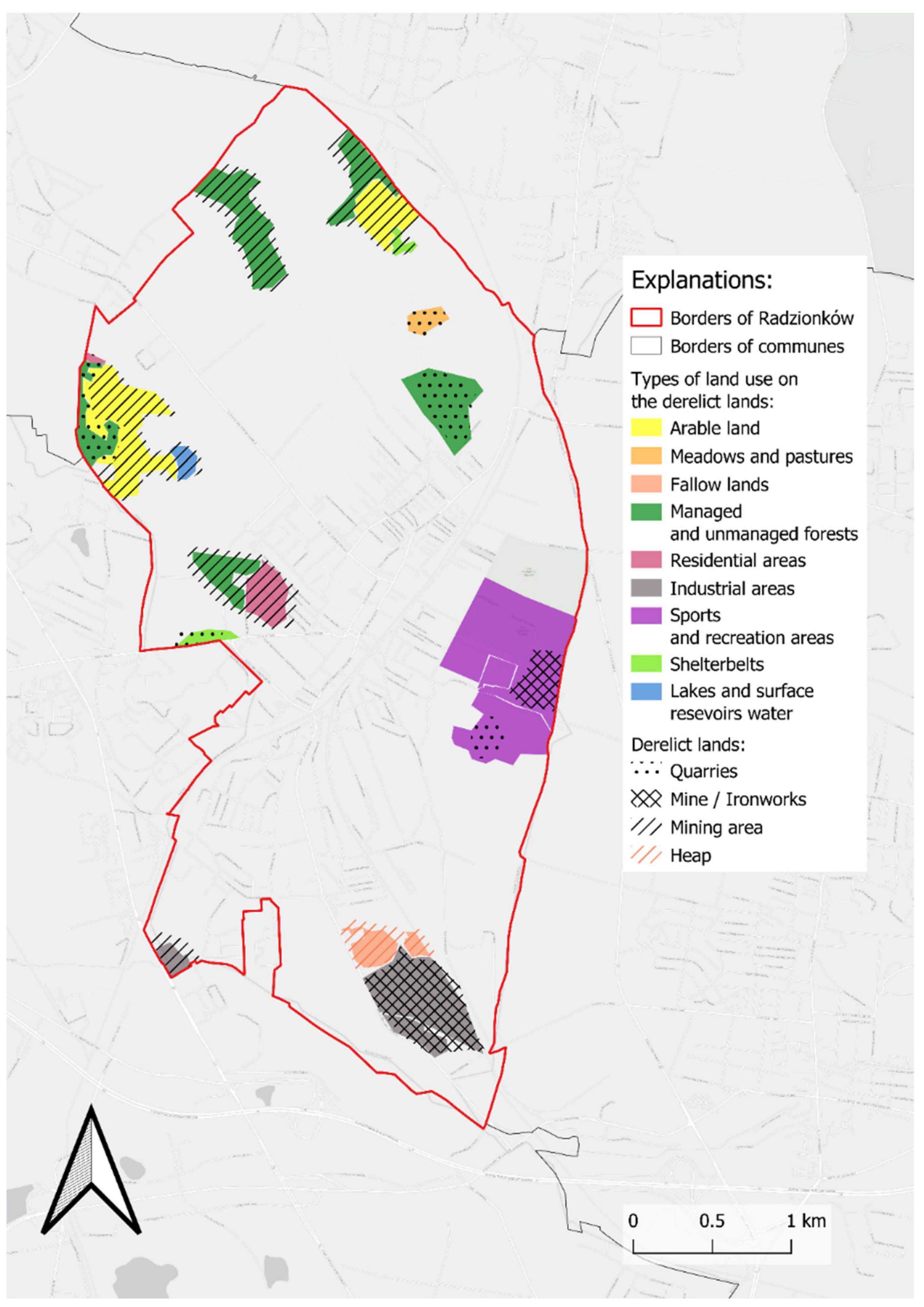
| Land-Use Type | Reclaimed Area | Previous Use | |
|---|---|---|---|
| ha | % of Total | ||
| Arable land | 33.77 | 2.55 | Mining areas |
| Meadows and pastures | 3.08 | 0.23 | Mining areas |
| Fallow land | 6.93 | 0.52 | The areas of the Radzionków Mine and Huta Łazarz |
| Managed and unmanaged forests | 53.94 | 4.08 | Mining areas/Quarry |
| Residential areas | 8.32 | 0.63 | Mining areas |
| Industrial areas | 30.03 | 2.27 | Mining areas/The areas of the Radzionków Mine and Huta Łazarz |
| Sports and recreation areas | 63.08 | 4.77 | Quarry/Glider airfield/Księża Góra Park |
| Shelterbelts | 3.83 | 0.29 | Mining areas |
| Lakes and surface reservoirs waters | 2.37 | 0.18 | Mining areas |
| Total | 205.35 | 15.52 | |
Publisher’s Note: MDPI stays neutral with regard to jurisdictional claims in published maps and institutional affiliations. |
© 2021 by the authors. Licensee MDPI, Basel, Switzerland. This article is an open access article distributed under the terms and conditions of the Creative Commons Attribution (CC BY) license (https://creativecommons.org/licenses/by/4.0/).
Share and Cite
Kantor-Pietraga, I.; Zdyrko, A.; Bednarczyk, J. Semi-Natural Areas on Post-Mining Brownfields as an Opportunity to Strengthen the Attractiveness of a Small Town. An Example of Radzionków in Southern Poland. Land 2021, 10, 761. https://doi.org/10.3390/land10070761
Kantor-Pietraga I, Zdyrko A, Bednarczyk J. Semi-Natural Areas on Post-Mining Brownfields as an Opportunity to Strengthen the Attractiveness of a Small Town. An Example of Radzionków in Southern Poland. Land. 2021; 10(7):761. https://doi.org/10.3390/land10070761
Chicago/Turabian StyleKantor-Pietraga, Iwona, Aleksandra Zdyrko, and Jakub Bednarczyk. 2021. "Semi-Natural Areas on Post-Mining Brownfields as an Opportunity to Strengthen the Attractiveness of a Small Town. An Example of Radzionków in Southern Poland" Land 10, no. 7: 761. https://doi.org/10.3390/land10070761