Review

Drivers, Impacts and Mitigation of Increased Sedimentation in the Hydropower Reservoirs of East Africa

1
School of Material, Energy, Water and Environmental Science, The Nelson Mandela African Institution of Science and Technology, Arusha P.O. BOX 477, Tanzania
2
School of Geography, Earth and Environmental Sciences, University of Plymouth, Drake Circus Plymouth, Devon PL4 8AA, UK
*
Author to whom correspondence should be addressed.
Land 2021, 10(6), 638; https://doi.org/10.3390/land10060638
Submission received: 28 April 2021 / Revised: 11 June 2021 / Accepted: 12 June 2021 / Published: 16 June 2021
(This article belongs to the Section Soil-Sediment-Water Systems)

Abstract

:
Hydropower reservoirs are essential for the climate-neutral development of East Africa. Hydropower production, however, is threatened by human activities that lead to a decrease in water storage capacity of reservoirs. Land use/land cover and climatic changes are driving accelerated soil erosion in semi-arid East Africa, which ultimately increases reservoir sedimentation and decreases energy production. Sediment delivery dynamics at the catchment scale are complex, involving the interaction of multiple factors and processes on different spatial and temporal scales. A lack of understanding of these processes and their interactions may impede the efficiency of sediment mitigation and control strategies. A deep understanding of the processes of erosion and connectivity of the land to river channel, as well as storage of eroded material within hillslopes and floodplains, and sediment accumulation in the reservoirs supports selection of future dam locations and sustainable management of reservoirs. The sediment budget approach can provide such a holistic perspective by accounting for the various sediment sources, transport, sinks, and redistribution when the sediment is routed through that catchment. Constructing sediment budgets is challenging, but the potential for integrating a number of different techniques offers new opportunities to collect the required information. In East Africa, the spatial planning of dams is mainly dominated by political and financial motives, and impacts of land use and climate on the sediment transport dynamics are not adequately considered. Production of sediment budgets under different scenarios of land use and climate change should be an essential step when deciding the location and management strategies for dams. Selection of new hydroelectric reservoir sites must consider long-term scientific data on climate change, and the sediment budget components for sustainable land management planning, hydropower sustainability.

1. Introduction

Hydropower reservoirs are essential for producing climate-neutral energy [1] and ensuring long-term energy stability for economic growth in developing countries [2]. In addition, they provide other essential economic and ecological resources, such as irrigation and drinking water sources for agriculture and livestock, recreational spaces, and fishing habitats [1,2,3,4,5]. The hydropower industry and its share of power production in East Africa are expanding linearly, while the East African population and its energy demands are growing exponentially [6]. Despite the key socioeconomic services they offer, hydropower reservoirs are currently threatened by changing water supply and sediment transport dynamics in wider catchments [6,7]. Unsustainable land use and climate changes increase soil erosion and sediment delivery rates, resulting in accelerating reservoir sedimentation [8]. Consequently, water storage capacity is decreasing, and energy production capacity is declining [8]. Moreover, increased sedimentation can cause flooding that may disrupt the local infrastructure. Among their longer-term negative impacts, mega-projects, such as hydropower constructions, could also often causes loss of life and property, and involuntary resettlement which could further lead to poverty [9,10]. By confining sediments to reservoirs, dams also hinder sediment transfer to the downstream river system, which subsequently lacks the sediment input required for maintaining channel shape and preserving the aquatic habitats [7]. In addition, sedimentation in reservoirs can add compressional forces to the dam structure, thereby exceeding the normal hydrostatic design, while clogging of water intake also hinders the production of energy [11].
Dynamics of sediment availability in a catchment are complex in time and space, and depend mainly on the climate, geology, topography, soil types, land cover, and land use [12]. The rapid expansion of agricultural land area with respect to population increase in Eastern Africa has led to an increase in the rates of soil erosion from large areas [13,14]. In upstream catchments, fluvial processes are susceptible to land use and land cover changes on the basin scale, resulting in robust landscape reactions by modifying processes of soil erosion, sediment transport, and deposition [15]. Conversely, natural climate variability and climatic changes in East Africa affect the hydrological cycle and, in turn, production capacity [16]. In addition, increased runoff and gully incision also lead to an increase in sediment connectivity and sediment supply, leading to rapid transport of eroded sediment to downstream sinks [17]. Increased erosion following land use or climate change and rapid downstream transport of eroded sediment is thus the biggest threat for the sustainability of reservoirs [8,18]. All these factors ultimately influence downstream siltation and sedimentation problems in dams/reservoirs [8,19].
While unsustainable land use, climate change, and natural climate variability influence sediment transport [19], the processes by which they change catchment hydrology are nonlinear in semi-arid East Africa, where the spatial and temporal dynamics of sediment connectivity are not well understood [20]. Such dynamics are often neglected in reservoir planning [21]. Sediment budgets as a functional reservoir management tool have rarely been established at the catchment scale in East Africa [22]. In this context, some pressing questions remain regarding hydropower management now and in the future. Are dam and reservoir systems managed in the same way the planners and designers intended [23] concerning managing sediment accumulation? Are there any consequences of the construction and operation of the dam that were not foreseen by the designers [23]? What are the processes and features controlling sediment connectivity and sediment supply to reservoir sink zones? What are the best techniques to assess reservoir sedimentation rates? What approaches can reduce the quantity of sediment incoming to the reservoirs from upstream? What degree of the induced climate change variations in rainfall and temperature affect sediment delivery dynamics, and can these be mitigated? These unknowns need to be answered and integrated into decision making for endorsements at early planning stages of future hydropower dams.
Informed policy decisions and innovative mitigation solutions are required to move hydropower towards sustainable practices and meet the rising energy demands while ensuring water availability in East Africa. This review presents an overview of reservoir siltation issues in East Africa, followed by a detailed description of the driving processes behind observed increases in sediment delivery. Subsequently, different methods to evaluate and quantify source siltation of hydropower reservoirs are discussed, with emphasis on their strengths and weaknesses. Finally, we give an overview of the mitigation options for reservoir sedimentation, emphasizing different techniques for (1) reducing the influx of sediments, (2) managing and evacuating sediments from reservoirs, and (3) replacing lost storage of the reservoirs. On this basis, this paper aims to provide a blueprint for sustainable catchment and reservoir management in East Africa.

2. Review Approach on Hydropower Development in East Africa

This review offers an insight of the scale of reservoir siltation issues in East Africa, with a subsequent detailed description of the driving processes behind observed increases in sediment delivery to hydropower reservoirs. Lack of information on potential sediment sources, soil erosion processes, and sediment yields from catchment areas are key restrictions for sustainable land use and reservoir management. The sediment budget concept integrates sediment transfer processes across all possible sources to all or any potential sinks in a system across the soil–sediment continuum of detachment, transport, and deposition. The production of sediment budgets for catchment areas should be an essential step during the spatial planning and formulation of management strategies for hydropower reservoirs. These sediment budgets can be established through a combination of different techniques for assessing the mobilization, redistribution, transport, and storage of sediments within a catchment area, including field assessment measurements, remote sensing GIS models, sediment core dating techniques, and sediment tracing. The sustainability of hydropower reservoirs can only be preserved through continued scientific monitoring on the dynamics of soil erosion and sediment transport in the wider catchment of the reservoirs. The summary of the major issues that make an annotated bibliography are discussed in the context of the framework depicted in Figure 1.

3. The Eastern African Social, Economic, and Environmental Context

3.1. The East African Environment

The East African region discussed in this study comprises eight countries, namely Sudan, South Sudan, Ethiopia, Kenya, Uganda, Rwanda, Burundi, and Tanzania, extending between 21° and 48° E and 11° S and 23° N, and covers an area of 5.6 × 10⁶ km2 (Figure 2).
It is noted, however, that river basins are not limited to political boundaries. The region’s climate is generally tropical with altitude effects on temperature and rainfall. The region’s average rainfall is 610 mm, but spatially variable with <300 mm in the lowlands and >1200 mm in the highlands [24]. Although there are no significant temporal trends in annual precipitation between 1960 and 2006 across the region, strong local trends of increasing or decreasing precipitation have been observed. High rainfall erosivity (R-factor) is primarily found in the highlands of East Africa [25]. However, intense rainstorms during the wet season in semi-arid areas can also result in temporally high rainfall erosivity [26,27]. The total population of East African countries is estimated to be 365 million [28] and is anticipated to exceed 700 million in 2050 [28]. The major land cover types include the cropland covering about 15% of the region, forest 23%, bareland 26%, and rangelands 34% [29]. Major soil classifications in the region were derived from the Harmonized World Soil Database (HWSD) [30]. Nitisols are typical for the highlands of Ethiopia, Kenya, Tanzania, and Uganda. They are predominantly deep and well-drained, with stable structure, and a high clay and nutrient content. The Acrisols are common in the wetter areas of Burundi, Rwanda, and Uganda. They are rich in clay and highly susceptible to erosion. Younger Cambisols are more common in Tanzania and Kenya, and are less susceptible to erosion; however, they are suitable for a wide variety of crops. The Andosols are also younger soils developed on recent volcanic deposits and are typical for the East African Rift System. They are usually very fertile and support some of East Africa’s most productive cropping areas. Arenosols are dominant in the drier regions of Sudan and are characterized by high sand content and lack of soil profile. They are weakly structured, have a low water retention capacity, and higher infiltration capacity. Vertisols, or ‘black cotton soils’, are typical of East Africa’s semi-arid grasslands and have a high clay content and low drainage capacity. Due to their cracking nature under seasonal changes in soil moisture, they still have relatively high erodibility [31]. Ferralsols are intensely weathered red soils, which are primarily found in wet tropical areas of Kenya, Tanzania, Uganda, Burundi, and Rwanda. They are less susceptible to erosion but have lower nutrient content [32]. The soil erodibility factor of these type of soils in the region ranges from 0.012 to 0.03 t ha h ha−1MJ−1mm−1, with high erodibility factors in Kenya, Ethiopia, Sudan, and Uganda ranging from 0.024 to 0.03 t ha h ha−1MJ−1mm−1, while Burundi, Rwanda, and Tanzania range from 0.012 to 0.023 t ha h ha−1MJ−1mm−1, except in the northern and southern highlands of Tanzania that were above 0.23 t ha h ha−1MJ−1mm−1 [25].
The landscape of Eastern Africa is diverse, ranging from the Danakil depression in Ethiopia to the highlands of Ethiopia, and the peaks of Mount Kilimanjaro (5895 m) and Mount Kenya (5199 m).

3.2. East Africa’s Increasing Demand for Hydropower

East Africa is undergoing rapid economic growth, with GDP growth rates ranging from 5.7 to 6.1, averaging 5.9% per year between 2016 and 2019 [33]. Since 2000, the energy consumption in the region has risen by an estimated 45% [34,35]. However, the development of regional energy systems has not met increasing demands [35]. The ineffective and unreliable nature of electricity production in East Africa could limit future economic growth [36,37,38]. Over 82 million people in East Africa still have no access to electricity [35]. The distribution is spatially uneven between and within the countries, and the areas that do have access are dependent on a high-cost, unreliable supply [34,35]. The combination of the rapidly growing population [39,40] and projected climate changes [40] create an urgent need for resilient hydropower management strategies [40]. A commitment to the development and sustainable management of hydropower electricity generation plants in East Africa is thus central to achieving sustainable growth [35,41].
Increasing hydropower capacity offers the potential to improve the energy security in East Africa, which is critical for the region’s socioeconomic growth [42]. The Renewable Energy Policy Network for the 21st Century (REN21) estimated that the region has approximately 13.4 GW of hydropower potential [43]. However, at the moment, hardly 16% of that potential is being exploited. Currently, hydropower is by far the major source of grid electricity in the region, with more than 6000 MW, followed by geothermal (598 MW), biomass cogeneration (110.5 MW), wind (25.5 MW), and solar (9.2 MW) [44]. In Tanzania, natural gas is also a major source of electricity production, contributing around 892.72 MW. However, many environmental and organizational challenges impede the region’s development of its hydropower potential. These include a shortage of technical know-how in planning [45], dynamic and unpredictable climatic and environmental conditions, increasing land use pressures, and a lack of legal and institutional frameworks for sediment management [19]. A better institutional framework is required to effectively integrate climate information into sustainable reservoir management. While the East African countries have drafted renewable energy policies, the approval rate of hydropower technology is unsound because of the lack of financial funds of East African governments, and the absence of know-how and co-operation between different stakeholder groups [46]. Therefore, present renewable energy policies should be co-ordinated, and the current practice appraised to increase the implementation of these technologies [46]. In this framework, hydropower can also be regionalized to improve grid stability and to sustain the exploitation of other sporadic renewable energy sources, such as wind and solar power [41].
In view of this discussion, the mandatory use of climate change information to decide the location of dams is imperative for projecting service life and risk mitigation strategies. Selection of new hydroelectric reservoir sites must consider long-term scientific data on climate change, the dynamics of erosion and sediment transport in the basin, sustainable land management planning, and the benefits of hydropower sustainability, and should not be dominated by political and fiscal considerations, petitioning, and negotiation.

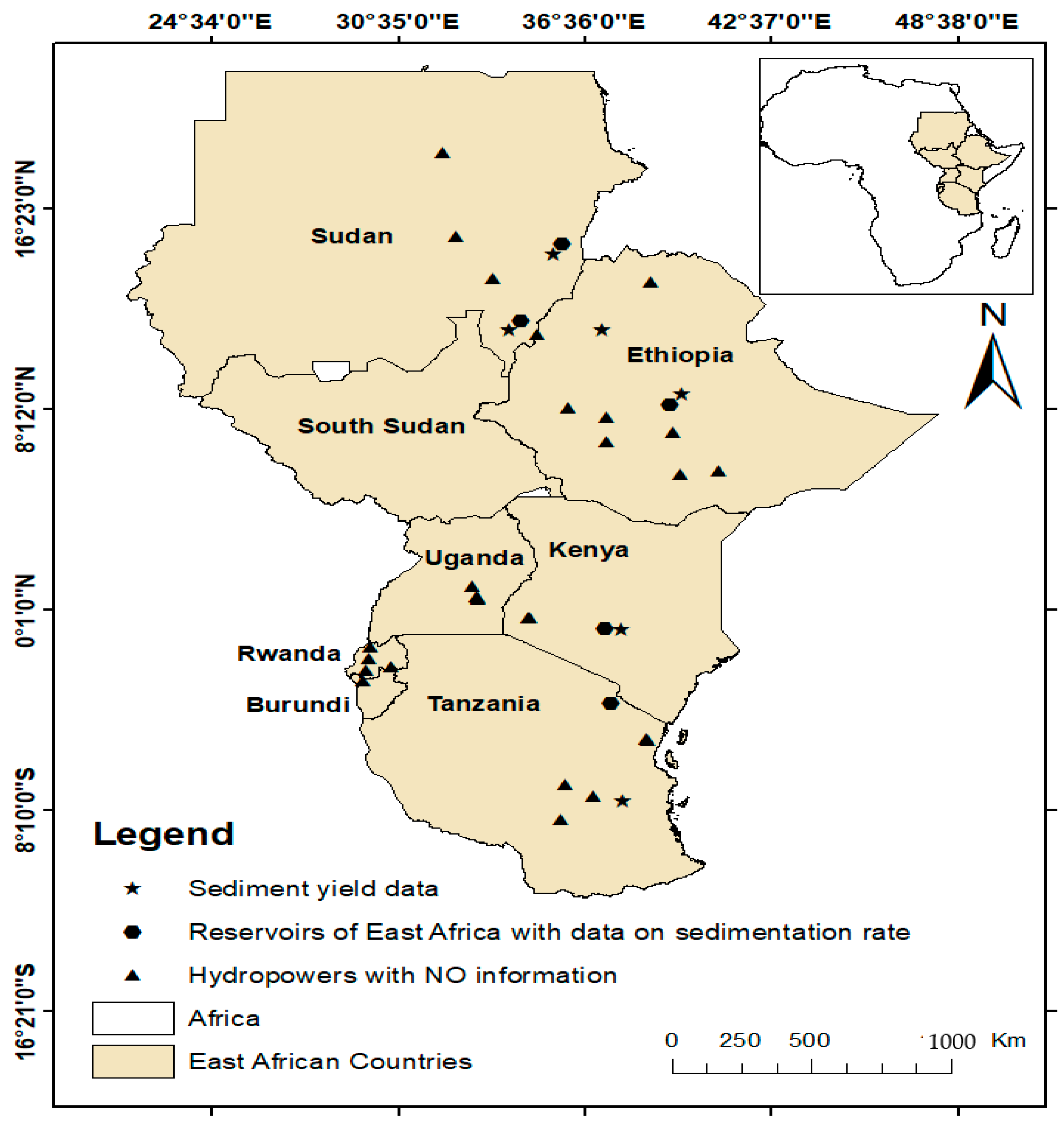
3.3. Changing Sediment Flux Dynamics in East African Rivers

Sustainable land management and water resource development in many developing countries [47] are susceptible to accelerated erosion and downstream sediment transport [48,49]. Siltation of reservoirs is of utmost concern in regions of semi-arid catchments where water is insufficient, and land degradation commonly leads to increased masses of sediments entering rivers and reservoirs [50]. The storage capacity of reservoirs in East Africa is being reduced by accelerated sedimentation, which jeopardizes food, water, and energy security [51,52,53,54]. For example, Vanmaercke, Poesen, Broeckx, and Nyssen [40] showed that the sediment yields in East Africa typically range between 100 and 1000 t/km2/year. Studies on hydropower reservoirs by [55,56,57,58] and [59,60] also indicated similar sediment yields within the hydropower catchments of East Africa (Table 1).
The service lifetime of a number of these reservoirs is thus reduced due to the unexpectedly high siltation rates [63]. However, sparce information on reservoir sedimentation impedes the spatial analysis of the problem in the region [59] (Table 2).
Across Africa, many reservoirs have experienced similar increases in their sedimentation rates through changes in delivery from contributing sources [14,64,65,66]. Sumi et al. [67] noted that, by 2100, about half of the global gross reservoir capacity of 6000 km3 will be lost, ignoring new storage built after that year [7]. Similarly, Annandale et al. [68] revealed that the net world capacity of reservoirs has decreased from its height of 4200 km3 in 1995, as sedimentation rates outweigh new storage construction rates. Furthermore, Basson [60] and Dreyer [69] predicted that an average of 80% of reservoir capacity in several continents of the world will be filled with sediments in the following years: Africa by 2100, Asia by 2035, Europe and Russia by 2080, and Central East and North America by 2060.
Increasing land use pressure is the major cause of increased erosion and accelerating sedimentation rates in East Africa. [54,70]. The loss of permanent vegetation through the fast expansion of agricultural land [71,72,73,74] has accelerated erosion and downstream sediment transport [14,75]. Wood and charcoal also remain the most utilized energy source within the region, which is driving the loss of forests and woodlands [74]. Moreover, the increase in the number of livestock and densities on rangelands has led to overgrazing and soil trampling [74,76,77]. The extent of the response of a catchment to loss of vegetation depends on the topography, soil, and natural climatic dynamics [78]. East Africa is characterized by a steppe climate with a dry season and one, or diurnal, rainy season [54]. These high-intensity runoff events are related to landsliding [79], mudflows [80], and gully erosion [81], and potentially cause catastrophic flooding downstream [82]. During such rainfall events, the erosional energy is more significant. It, therefore, can lead to extreme levels of sediment transport, which increases the danger of reservoir infilling, as well as serious wider ecological consequences downstream [83].
While natural climatic variations and global climate change may affect erosion and downstream sediment transport [84], unsustainable land use change is plausible to magnify the impacts of hydroclimatic drivers of erosion by water, with unknown outcomes for community resilience and development [70]. The climate-driven vegetation change that impacts the abrupt change of ecological systems and ecosystems has shown to steer to more extreme responses to natural climate fluctuations [85]. Furthermore, global climate change alters the dynamics of river flow and discharge. The effects of global climate change on hydropower are uncertain due to regional differences, depending on changes within the flow regimes, and the variation of the rainfall and temperature [37]. The construction of reservoirs also significantly impacts sediment connectivity by halting the downstream sediment flux [86,87,88]. There is increasing evidence of ‘hungry water’ effects due to sediment starvation downstream of dams, resulting in increased channel erosion and other ecosystem impacts [89,90,91,92,93]. Coastal areas and river deltas that depend on the supply of riverine sediment are mostly susceptible to the effects of the supply of reduced sediment [7,86]. This can lead to the disappearance of beaches, increased coastal erosion [7,94,95], and the subsidence of deltas [96]. Significant proportions of the sediment transported by many rivers originated from eroded agricultural soil; consequently, the extent of this change quantifies the degraded land and the corresponding soil resource reduction [97]. Whilst catchment erosion is known to be responsible for the accelerated sedimentation in the dams’ reservoirs [98], little is understood on the spatial and temporal dynamics of erosion–sedimentation processes and sediment connectivity on a catchment scale.

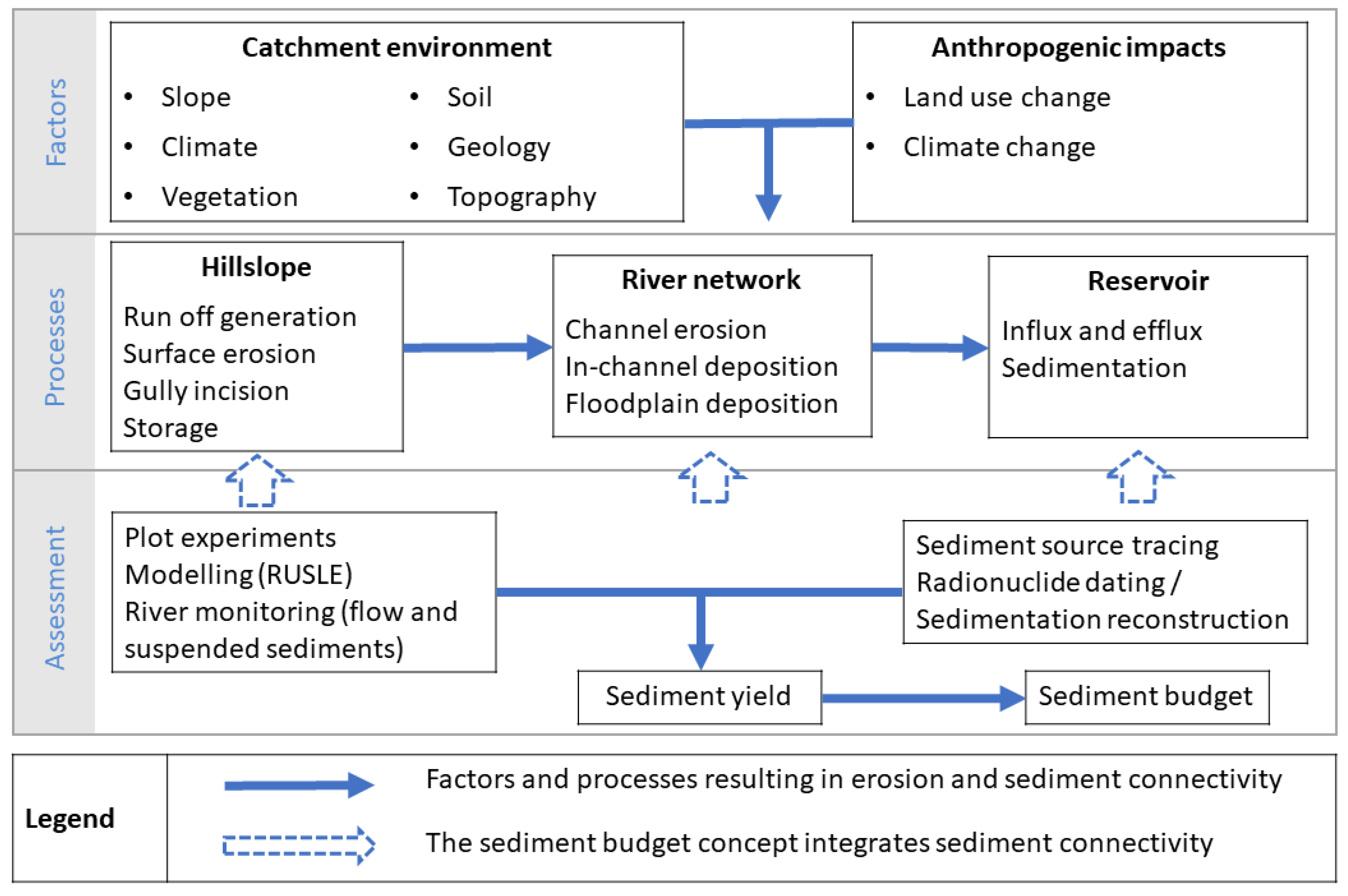
4. Tools for Assessing Soil Erosion, Sediment Yield, and Sedimentation Rates to Support Sediment Management

4.1. Experimental Plots and Field Survey

Studies of soil erosion are conducted on various spatial scales, ranging from plots to continental catchments [99]. On the most miniature scale, experimental plots [100,101,102] and field measurements [102,103,104,105,106] can be directly used to quantify the rates of erosion. However, these small plots [107] are not necessarily representative of the whole catchment system [108,109,110,111]. Plot studies cannot easily be extrapolated to entire catchment systems, and implicate substantial uncertainties when extrapolated to other catchments in different regions [40,112,113,114,115,116,117]. Moreover, plot studies can restrict information on certain types of erosion process, like the periodicity and severity of rill erosion and the components governing the between-field and within-field variations [105,109,118]. Hence, erosion rates determined on test plots may not comprehensively reflect the entire erosion in a catchment [119]. Furthermore, field studies require measurements over multiple years to capture the variance resulting from natural environmental fluctuations [120].

4.2. Remote Sensing GIS Models

In recent decades, modelling has become an increasingly important method for estimating the dynamics and quantities of eroded sediment [121]. Models such as the ‘Revised Universal Soil Loss Equation’ (RUSLE), [122] the ‘European Soil Erosion Model’ (EUROSEM) [123], and the ‘Water Erosion Prediction Project’ (WEPP), [124] have been developed to estimate erosion at different spatial and temporal scales [125]. These models differ in terms of origin (e.g., empirical versus process), processes considered, complexity, data requirements, and implementation potential [120]. While the process-based models require larger quantities of input data and calibration routines [25], empirical models require less input data while maintaining the most factors, like the physical characteristics (e.g., topography, geology, land use, climate) that effect the erosion process [25,122], as long as the conditions for model development are relevant to the world of application. The process-based models are also limited in the accuracy of the soil loss rate estimation [25,48], but arguably capture process interaction and feedback more realistically. In East Africa, the combination of environmental heterogeneity and poor data availability [25] constrains the use of complex, data-hungry, process-based erosion models in larger spatial domains [25]. East African erosion modelling applications often must use the models in data-poor catchments [126,127,128]. In this context, current empirical methods, such as RUSLE, are extensively applied in the East African region, principally due to their average demand for data and ability to incorporate with GIS databases, which aids the upscaling process [25,129,130,131]. With the advantage of GIS, the RUSLE model can foresee the likely erosion on a cell-by-cell basis [132], which is useful when striving to spot the spatial pattern of the soil loss present within an outsized area [133]. The soil loss computed by RUSLE model for every pixel [122] predicts the erosion related to runoff like the landscape heterogeneity factors (soil type, slope, topography, vegetation, geology, land use, climate) that impact the soil erosion process [25,122]. However, the model represents only one aspect of the entire erosion spectrum because it was established solely to predict sheet and rill erosion [25] and did not account for other erosion processes. Therefore, in areas where gully erosion and streamline incision processes are dominant [70,122], this model does not achieve the goal. Additionally, the RUSLE model does not predict on-site changes in susceptibility to erosion in response to process change, and is less effective for studying source-to-sink dynamics in large and complex catchments [74]. Furthermore, the model does not consider certain important factors for erosion dynamics, such as sediment supply and overland flow initiation dynamics [74].
Applications of the RUSLE model, therefore, benefit from combination with other sediment evaluation tools, like sediment tracing source techniques, which will provide complementary evidence to explore the knowledge of source-to-sink dynamics within the catchment. This complementarity also provides a reciprocal validation of the proportional contribution from areas of high erosion risk [74,134]. Coupling RUSLE models with other models for plotting susceptibility to other erosion processes (e.g., mass movements and gully, riverine, and wind erosion) would provide an improved representation of the entire erosion susceptibility [74,135]. Not all approaches to monitor, assess, and estimate erosion are suitable at all scales [102]. For example, no model matches all hydrologic conditions [136,137] because each model has specific assumptions and limitations. Therefore, different methods to monitor, assess, and estimate sedimentation will be appropriate at different spatial and temporal scales.
There are no particular models specifically designed for East African conditions, so critical values of model parameters for current models are likely to be beyond the constraints under which these models have been created [138]. Most models assume a steady state, whereby modifications in catchment environments are directly propagated to the sediment flux at the catchment outlet [139], but ignore temporal changes in sediment connectivity. The concept of connection–disconnection between the slopes and the channel network (hillslope–sediment delivery ratio) is thus vital, since the quantity of the sediment getting into the river network predominantly depends on the catchment connectivity [140,141].

4.3. Sediment Source Apportionment

Pinpointing and mitigating hotspot soil erosion areas contributing to high sediment yields is a key factor for building sustainable soil-water conservation measures in reservoir catchments [142,143]. Thus, sediment control strategies require confirmation on the relative and absolute contributions of sediment from different sources [144]. As highlighted in previous sections, traditional techniques are commonly constrained by spatial and temporal scale challenges and data availability [144,145,146]. Therefore, sediment source fingerprinting techniques have emerged to couple upstream erosion with downstream sedimentation measurements [134,147,148]. These techniques can offer comprehensive information of source-to-sink dynamics within the catchment and ensure the proportional source contribution and pinpointing areas of high risk [134,149]. Sediment source fingerprinting techniques were established to underpin the similarities between the physical or chemical traits of downstream sediments with the catchment potential sediment sources [144,146,150]. These techniques can produce valued evidence on the relative significance of specific possible sources contributing to the downstream sediment flux of a river and reservoir [151]. Such information is vital for supporting evidence on the connections between upstream potential sediment sources and downstream sediment yield [152], essential for targeted sediment control measures. These techniques also provide essential information about the transfer of sediment through the landscape at various temporal and spatial scales [153].
Different properties of soil and sediment can be used as tracers to distinguish between specific land use types, erosion processes, and catchment zones. Fallout radionuclides (FRN) activities are usually greater in topsoil materials and less in subsoil materials [154,155], making them useful in distinguishing surface from subsurface materials, as well as cultivated and uncultivated agricultural surface soils [156]. Subsequently, sediment source apportionment using FRNs [156,157,158,159] tends to be at a more generic surface–subsurface level. In this context, the use of single component signature to distinguish between the potential sources of the sediment features a high uncertainty and sometimes leads to false associations between source and sediment [160]. Most fingerprinting studies use multivariate and composite fingerprints that encompass various distinctive diagnostic signatures affected by different environmental factors, thus improving the validity of discrimination of sediment sources [161]. The integration of many parameters forms a multivariate fingerprint [162] that permits for an increased number of sources to be modelled and is assumed to be more reflective of the associations between sediments and their sources [163]. This reduces the risk of unlikely matches that might be theorized to occur with individual tracer properties [163,164]. Subsequently, the quantitative examination is performed to ascertain the relative contribution of every possible source to the collected target sediment samples, and these often depend on unmixing models [144]. These models use multivariate fingerprints for source tracking and ascertain the relative significance of specific sediment source types in various circumstances [158,165,166,167]. Routinely, these models need tracer data that interpret both the sources and mixture; these qualities are anticipated to conservatively transfer from sources to mixtures through a mixing process [168].

4.4. Reconstructing Reservoir Sedimentation Rates

Reconstructing changes in reservoir sedimentation rates is crucial for evaluating the size of siltation problems and, therefore, the durability of hydropower reservoirs. Both nonradiometric and radiometric dating methods often estimate sedimentation rates. The nonradiometric methods (such as ecological or pollution markers) can provide distinct stratigraphic time markers, which can be used to estimate the average rate of sedimentation between the dated layers. Radiometric dating, however, can provide a continuous age determination for lake/reservoir sediments [169,170]. The FRNs, 210Pb and 137Cs, are employed to study erosional records of a catchment and, therefore, the effects of land use and climate by presenting data over the last 100–150 years for different time windows [170]. The fundamental ability of 210Pbex to provide evidence on the chronology of a sediment deposit and thus estimate the sedimentation rate depends on its source, its moderately long half-life, its global distribution, and its retrospective assessment that provides a longer-term (ca 100 year) chronology or age–depth relationship [171]. 137Cs is an anthropogenic radionuclide from weapon testing fallout that peaked in the early 1960s. However, its fallout in tropical Africa was low, challenging its application [172]. 210Pb is a natural geogenic radionuclide; its deposition is continuous and constant from year to year [173]. Generally, the rate of decrease of 210Pbex (i.e., the fallout component) activity with depth in a sediment core offers the foundation for developing an age–depth correlation and estimating sediment accumulation rates (SAR) [170]. From its activity profile, it is feasible to determine the sedimentation rate and, in some conditions, to reconstruct environmental changes [173] through time using numerous models accounting for a number of different assumptions [173,174,175,176].
Most of the East Africa hydropower reservoirs are located on complex catchments which encounter catchment-wide environmental changes [66]. In this context, the constant rate of supply (CRS) model developed by Appleby et al. [174] is the most applicable to account for changes in the rates of sedimentation using the initial concentration of 210Pbex activity in the sediment [66]. The CRS model [174,177,178] depends on the assumption that the 210Pb flux to sediment is constant over time, while the sedimentation rate may vary [179,180]. In the model, the attention is focused to the downcore reduction in 210Pbex activity, which, in turn, reflects the sedimentation rate and natural radioactive decay, whereby high sedimentation rates will result in slower declines in the vertical 210Pbex activity profiles. On the other hand, lower sedimentation rates will result in steeper decreases of the vertical 210Pbex activity profiles [173,181].
Geochronological model assumptions might be challenged, however, when a substantial proportion of 210Pbex supply enters the water column derived from mobilized catchment material [66,182], where differences in the existing 210Pbex activities of the transported and deposited sediment might occur due to the natural differences in the geological prevalence of 238U and/or variation in dominant erosion processes [66]. Additionally, the changes in dominant abrasion processes within a channel network can alter the fraction of topsoil versus subsurface material within the transported sediment, thereby affecting the 210Pbex activity of input sediment to the sediment column [66,183,184]. This variability in the input of 210Pbex requires independent methods to scrutinize the CRS model [185]. Most often, the 137Cs (t1/2 = 30.17 years) peak fallout has been used [186]. In the southern hemisphere, however, the activity concentration of 137Cs in soil and sediment is low and, in some cases, the geochemical profiles of sediment cores have been shown to exhibit changes that might have been associated with hydrological or volcanic events [66,187,188] that preconcentrate detrital 137Cs input (e.g., through selective erosion of fine sediment from the catchment) instead of direct fallout intrinsically. Other limitations for the determination of SAR using 210Pb occur when the environmental settings pose special interpretive problems, like depositional regime dominated by episodic large-scale turbidity currents or debris flow. In this situation, it is difficult to estimate SAR quantitatively because the stratigraphic sequences are either reworked or mixed by gravity flows, or are interspersed with occasional event layers that compromise 210Pbex profiles [189], but, in many cases, an indication of broad rates of SAR change can still be determined, which is of value to managers.

4.5. The Sediment Budget as a Foundation for Sustainable Reservoir Sediment Management

Understanding the processes that result in erosion and its connectivity to the river channel, storage in hillslopes, floodplains, and sediment accumulation in the reservoirs is vital for the choice of dam location and for the sustainable management of the reservoirs [190]. Sediment connectivity processes through time integrate sediment transfer processes across and sinks along the soil–sediment continuum of detachment, transport, and deposition [191]. The process of sediment delivery in the catchment is complex; it involves the interaction of multiple factors and processes on different spatial and temporal scales [192,193]. These complex systems cannot be understood by examining outcomes alone (e.g., sediment yield or SDR) [138]. The complexity of processes, feedbacks, and consequences require a system-wide perspective [138]. The sediment budget approach provides such a holistic perspective by accounting for the various sediment sources, transport, sinks, and redistribution when the sediment is routed through that catchment [138]. Policy makers and catchment managers can use the sediment budget approach as a realistic mechanism for targeting mitigation measures/strategies [152,190].
Development of suitable sediment management strategies entails the quantification of sediment flux and links their transport dynamics to drivers, both within the channel and the broader catchment, to reliably forecast sediment discharge in rivers over relevant time scales of management [141,191,192,193,194]. Nonetheless, the spatial and temporal aspects of sediment transport factors and process interactions in rivers have not been fully captured and understood yet [141]. The potential of employing sediment budgets to improve understanding on the catchment fluxes has increased following the latest established advanced techniques and further evolved insights [195]. The quantification of catchment-wide sediment budgets involves a large number of components to be integrated at various spatial scales and for prolonged timescales.
Although the essential requirements of budgeting sediments are steadily developed and extensively used [195], there has been a limited application to support mitigation of hydropower sediment problems. Nonetheless, there is much potential here to be exploited. Field assessment measurements can provide an empirical quantification of sediment storage, erosion processes, and flux rate or water/particle residence time [102]. Modelling has the potential to provide the functional relationships between erosional processes and dominant factors influencing rates of erosion, and predict sediment yield within catchments both in spatial and temporal scales [40,195,196,197,198]. Sediment source tracing has the potential to establish hillslope–channel connectivity knowledge that provides new opportunities and skills for establishing sediment sources, obtaining spatially distributed and temporally integrated data on sediment mobilization, delivery, and storage [195]. Sediment core dating techniques provide an opportunity to reconstruct changes in sedimentation rates over time, which ultimately allows the association of sediment flux with forcing factors, including climate and human activity [198]. The age–depth model is often taken as a proxy for the assembly of a chronostratigraphy for sediment budgets and to estimate catchment erosion [199,200]. However, the notion of sediment budget involving the quantification of sediment storage components remains challenging and time-consuming [201]. Following this, most studies that have been undertaken to determine a catchment sediment budget have involved a combination of several different techniques/methodologies that mutually offer the required information on sediment mobilization, redistribution, transport, and storage within a catchment [121,202,203,204,205]. The potential for integrating contemporary developments in sediment tracing with more conventional monitoring techniques has created new opportunities to collect the required information for sediment budget production [152,161,202,206,207]. To this end, poor reservoir planning during the design phase remains the main reason for the rapid sedimentation and anticipated sediment yield. The absence of sediment yield data and absence of suitable methodologies to forecast sediment yield is an attribute of poor planning of the reservoir during the design phase. In this context, sediment budgeting remains an imperative method for comprehending and forecasting sediment delivery to the reservoir basin as one of the mitigation strategy goals. This method should not be replaced by faster sediment flux quantification approaches; instead, the synergistic application of both approaches improve tackling of hydropower sediment challenges.

5. Mitigating Reservoir Siltation in East Africa

There are different options to intercept and avoid the sedimentation of hydropower reservoirs [208] that range across precautionary, attendant, and corrective actions. In the first place, ‘precautionary’ actions can be taken to promote the reduction of sediment entry, including the reduction of upstream soil and channel erosion, and, in addition, sediment traps upstream of the reservoir [208]. Second, the ‘attendant’ action involves the passage of sediment around or through the reservoir, maintaining sediment transport and reducing sediment deposition through engineering approaches to modify the flow. The ‘corrective’ action involves dredging sediments or facilitating sediment washing by adopting specific dam operations [7,195] (Table 3). However, these actions require specific knowledge and a solid evidence base of process quantification that influence the entrapment of sediments and those affected by these specific actions to improve their development and evaluation. Therefore, the entrapment of sediments in reservoirs is not only a question of the reservoir’s capacity [208].

5.1. Reducing Sediment Entry

5.1.1. Catchment Soil and Water Management

Prevention of hydropower sediment problems begins with a sustainable land use management plan, since unsustainable land use change is not entirely irreversible. Studies have evidenced a dramatic decrease in river sediment flux after afforestation, revegetation, and sustainable grazing management programs [209,210], and, similarly, agricultural practices that emphasize soil conservation, such as tillage and crop management; terrace construction has been shown to decrease soil erosion and downstream sediment transport around the world [211]. In addition, stone bund terracing forms a barrier that slows down water runoff, allowing water retention and infiltration into the soil, improving rainwater harvesting and increasing the amount of water available to the soil plants [212]. Although soil and water conservation programs increase water retention and reduce soil erosion on site, their implementation also enhances soil productivity [213]. Experimental data from erosion plots and associated monitoring programs are used to demonstrate the effectiveness of on-site soil protection measures in reducing soil loss [213]. Still, there is much less evidence of the effectiveness of catchment-wide soil and water protection and sediment control programs in the reduction of the downstream sediment flows [208,214]. In the context of this study, the main objective is to reduce downstream sediment transport. A variety of soil protection measures, including tree planting and construction of terraces and gully check dams, are [213] used for the reduction of sediment downstream [215].

5.1.2. Sediment Trapping Upstream of the Dam

Check dams within the catchment tributaries and hillslopes reduce the sediment yield to downstream reaches in two ways [7]: firstly, by inducing the deposition of debris flows and reducing the erosion rate in the hillslope, and, secondly, by limiting the sediments before they reach the downstream reservoir [7]. First and foremost, the small control dams lower the channel gradient locally and, thus, influence the discharge of debris flows and the transport of river sediments, as the energy dissipated in the control dams, reducing the gradient in between [7]. The control dams also focus water flow through the channel centerline to mitigate the channel tendency to undercut the side slopes [7]. Second, the accumulated sediment volume trapped in small control dams is usually trivial, so larger control dams have also been built to store sediment before reaching a larger reservoir downstream [7]. The obvious problem with this method is that the dams fill up with sediment and, in river basins with high sediment yield, this can occur quickly and lead to some new complications with multiple reservoirs filled with sediment, the maintenance of which may be unstable and costly [7]. Maintenance of the main channel sediment traps through dredging is essential, but there is an opportunity to recycle nutrient-rich sediments as a growing medium or soil improver [216].

5.1.3. Structure Design for Sediment Removal to Reduce Sedimentation

When designing new dams and reservoirs, care is imperative to consider minimizing sediment build-up. Various approaches to managing sedimentation in reservoirs range from preventing sediment from entering the reservoir to sediment removal techniques [217]. However, climate change and land use factors are still seldom incorporated by water managers into the decision-making processes [218]. Numerous sediment removal techniques from the reservoirs have been adopted [63], taking into account the different climatic, hydrological, and geographical conditions [63].

5.1.4. Sediment Bypass/Pass Through

Sediment bypass systems act during major flood events to reroute incoming sediment-laden waters, preventing sediment from entering the reservoir [219]. It may be by seasonal drawdown, by drawdown adapted to floods, or by turbidity currents. Sediment bypass requires implementing the necessary bottom gates to be designed with great care [49,220]. A reservoir functioned through periodic drawdown is partly or entirely emptied during the flood season [221]. Seasonal drawdown is conducted during a predetermined period annually, as opposed to flood routing, which needs the reservoir level to be drawn down for individual flood events when they occur [221]. At some sites, routing can be implemented at a very low cost [7]. A major drawback of sediment routing is that a substantial amount of water must be released during floods to transport sediments [221]. Sediment management is best suited for hydrologically small reservoirs in which the water is massively drained [69], floods that transport sediments exceed the storage capacity, and leakages are available for the release of sediments without affecting the beneficial uses [7,221,222].

5.1.5. Sediment Flushing

Hydraulic flushing entails reducing the water level by opening an outlet with a low filling level to conditionally establish a river flow through the outlets [223]. In contrast to sediment routing, which attempts to prevent deposition during major events or the period of sediment entry, flushing uses drawdown or emptying to promote scouring and release of sediment after it has been deposited [89]. One drawback of flushing is downstream ecological or infrastructure impacts that occur with notable adjustments in flow and sediment rates; such drawbacks may inhibit many flushing occasions [221] due to lobbying from other stakeholder groups outside the hydropower industry. Usually, flushing cannot prevent siltation of the reservoir, but may, after some years, establish a balance between more sediment inflows and flushed sediment outflows [221]. Flushing in large hydropower reservoirs could also be essential for displacing sediments from live to dead storage and maintaining sufficient storage capacity upstream of the reservoir for regular power peaks [221].

5.1.6. Dredging

Dredging is one of the most costly mitigation techniques for hydroelectric sedimentation challenges, as it collects sediment from the bottom and places it in a different location [49,224]. An appropriate dumping location of dredged material is crucial, as dumped material should not come back into the reservoir [224]. The selection of dumps for dredged material and study of their efficiency should be investigated before starting dredging operations. The high costs of dredging and treatment of sediments, and the deposition of (fine) material outside the reservoirs is another drawback for sediment management [224]. However, recycling the dredged sediments back to the agricultural fields may offer a sustainable solution to nutrient losses from agricultural soils through soil erosion [216].
While it is challenging to separate the impacts of climate change from other changes in the river basin condition, its impacts cannot be ignored. Furthermore, ignoring the issues of land use, climate change, and political bureaucracy in making decisions about the spatial planning of dams can lead to detrimental effects of dam outages where there is lack of a holistic approach to sediment management measures. To this end, government-mandated land use conservation schemes and information on climate change should be among the appropriate approaches for reservoir planning before implementation.

6. Conclusions

There is a dearth of data on sedimentation rates in East African hydropower reservoirs. Available sediment yield data derived from reservoir sedimentation rates are mainly for larger catchments, which suggest that smaller catchments are poorly represented. The availability of these datasets remains relatively low or scarce across the region. The main reason for this under-representation is the limited number of studies and data availability of sedimentation rate in hydropower reservoirs in East Africa. This represents a key restriction for sustainable land use and reservoir management. Data scarcity and limited studies have posed a significant challenge for national and regional planning towards reducing soil erosion. It also likely impairs the willingness of international organizations and decision-makers to invest in measures that could help tackle soil erosion for basin-wide benefit. In addition to the recommendations given from the previous discussion, this study endorses the importance of establishing sediment budgets for hydropower catchment areas through a combination of different techniques/methods described in this contribution. Integration of techniques provides the necessary information for mobilization, redistribution, transport, and storage of sediments within a catchment area. These parameters should be assessed during the hydropower project design phase and supplemented by applying available models that spatially integrate sediment connectivity from the source to the sink. In this way, estimates can be made of the average annual or periodic volume and/or weight of the sediment load transported from the river into the reservoir. This study also recommends that the centralized governments in East African countries develop and/or implement mandatory climate information action in decision-making in the design of hydroelectric dams. This information is crucial for better implementing soil erosion control measures, where optimal action can be taken to achieve the best possible efforts and resources.

Author Contributions

A.A.: conceptualization, methodology, writing—original draft, resources, writing—review and editing; M.W.: conceptualization, methodology, writing—review and editing, supervision; W.B.: conceptualization, methodology, writing—review and editing, supervision, validation; K.M.: conceptualization, methodology, supervision. All authors have read and agreed to the published version of the manuscript.

Funding

This research was funded by the Center for Water Infrastructure and Sustainable Energy Futures (WISE-Futures), grant number ACE (II).

Institutional Review Board Statement

Not applicable.

Informed Consent Statement

Not applicable.

Data Availability Statement

The data used to support the findings of this study are included in this article.

Acknowledgments

The authors would like to extend their gratitude to the Center for Water Infrastructure and Sustainable Energy Futures (WISE-Futures), one of the East and Southern Africa Higher Education Centers of Excellence ACE (II) supported by the World Bank for funding the PhD project to the first author.

Conflicts of Interest

The authors declare no conflict of interest.

References

  1. Hauer, C.; Wagner, B.; Aigner, J.; Holzapfel, P.; Flödl, P.; Liedermann, M.; Tritthart, M.; Sindelar, C.; Pulg, U.; Klösch, M.; et al. State of the art, shortcomings and future challenges for a sustainable sediment management in hydropower: A review. Renew. Sustain. Energy Rev. 2018, 98, 40–55. [Google Scholar] [CrossRef]
  2. EU. Directive 2009/28/Ec of the European Parliament and of the Council of 23 April 2009 on the Promotion of the Use of Energy from Renewable Sources and Amending and Subsequently Repealing Directives 2001/77/Ec and 2003/30/Ec; EU: Brussels, Belgium, 2009. [Google Scholar]
  3. Vörösmarty, C.J.; McIntyre, P.B.; Gessner, M.O.; Dudgeon, D.; Prusevich, A.; Green, P.; Glidden, S.; Bunn, S.E.; Sullivan, C.A.; Liermann, C.R.; et al. Global threats to human water security and river biodiversity. Nature 2010, 467, 555–561. [Google Scholar] [CrossRef] [PubMed]
  4. Creţan, R.; Vesalon, L. The Political Economy of Hydropower in the Communist Space: Iron Gates Revisited. Tijdschr. Econ. Soc. Geogr. 2017, 108, 688–701. [Google Scholar] [CrossRef]
  5. Llamosas, C.; Sovacool, B.K. The future of hydropower? A systematic review of the drivers, benefits and governance dynamics of transboundary dams. Renew. Sustain. Energy Rev. 2021, 137, 110495. [Google Scholar] [CrossRef]
  6. Palmieri, A.; Shah, F.; Annandale, G.; Dinar, A. Reservoir Conservation: Economic and Engineering Evaluation of Alternative Strategies for Managing Sedimentation in Storage Reservoirs; World Bank: Washington, WA, USA, 2003; Volume 1. [Google Scholar]
  7. Kondolf, G.M.; Gao, Y.; Annandale, G.W.; Morris, G.L.; Jiang, E.; Zhang, J.; Cao, Y.; Carling, P.; Fu, K.; Guo, Q.; et al. Sustainable sediment management in reservoirs and regulated rivers: Experiences from five continents. Earth’s Future 2014, 2, 256–280. [Google Scholar] [CrossRef]
  8. Ali, Y.S.; Crosato, A.; Mohamed, Y.A.; Abdalla, S.H.; Wright, N.G. Sediment balances in the Blue Nile River Basin. Int. J. Sediment Res. 2014, 29, 316–328. [Google Scholar] [CrossRef]
  9. Gutman, P. Involuntary resettlement in hydropower projects. Annu. Rev. Energy Environ. 1994, 19, 189–210. [Google Scholar] [CrossRef]
  10. Vãran, C.; Creţan, R. Place and the spatial politics of intergenerational remembrance of the Iron Gates displacements in Romania, 1966–1972. Area 2018, 50, 509–519. [Google Scholar] [CrossRef]
  11. Annandale, G.W.; Morris, G.L.; Karki, P. Extending the Life of Reservoirs: Sustainable Sediment Management for Dams and Run-of-River Hydropower; The World Bank: Washington, WA, USA, 2016. [Google Scholar]
  12. Marttila, H.; Klöve, B. Dynamics of erosion and suspended sediment transport from drained peatland forestry. J. Hydrol. 2010, 388, 414–425. [Google Scholar] [CrossRef]
  13. Kidane, D.; Alemu, B. The effect of upstream land use practices on soil erosion and sedimentation in the upper blue nile basin, Ethiopia. Res. J. Agric. Environ. Manag. 2015, 4, 55–68. [Google Scholar]
  14. Hathaway, T. What cost Ethiopia’s dam boom. A look inside the Expansion of Ethiopia’s Energy Sector: International Rivers, People Water. Life 2008. Available online: https://archive.internationalrivers.org/sites/default/files/attached-files/ethioreport06feb08.pdf (accessed on 25 November 2020).
  15. Liébault, F.; Gomez, B.; Page, M.; Marden, M.; Peacock, D.; Richard, D.; Trotter, C.M. Land-use change, sediment production and channel response in upland regions. River Res. Appl. 2005, 21, 739–756. [Google Scholar] [CrossRef]
  16. Lalika, M.C.; Meire, P.; Ngaga, Y.M.; Chang’A, L. Understanding watershed dynamics and impacts of climate change and variability in the Pangani River Basin, Tanzania. Ecohydrol. Hydrobiol. 2015, 15, 26–38. [Google Scholar] [CrossRef]
  17. Blake, W.H.; Boeckx, P.; Stock, B.C.; Smith, H.G.; Bodé, S.; Upadhayay, H.R.; Gaspar, L.; Goddard, R.; Lennard, A.T.; Lizaga, I.; et al. A deconvolutional Bayesian mixing model approach for river basin sediment source apportionment. Sci. Rep. 2018, 8, 1–12. [Google Scholar] [CrossRef] [Green Version]
  18. Garzanti, E.; Andò, S.; Vezzoli, G.; Megid, A.A.A.; El Kammar, A. Petrology of Nile River sands (Ethiopia and Sudan): Sediment budgets and erosion patterns. Earth Planet. Sci. Lett. 2006, 252, 327–341. [Google Scholar] [CrossRef]
  19. Lumbroso, D.M.; Woolhouse, G.; Jones, L. A review of the consideration of climate change in the planning of hydropower schemes in sub-Saharan Africa. Clim. Chang. 2015, 133, 621–633. [Google Scholar] [CrossRef] [Green Version]
  20. Saavedra, C. Estimating Spatial Patterns of Soil Erosion and Deposition of the Andean Region Using Geo-Information Techniques: A Case Study in Cochabamba, Bolivia. Ph.D. Thesis, Wageningen University, Wageningen, The Netherlands, 6 December 2005. [Google Scholar]
  21. Harrison, G.; Whittington, H. Impact of climatic change on hydropower investment. In Hydropower in the New Millennium; CRC Press: Boca Raton, FL, USA, 2020; Volume 1, pp. 257–261. [Google Scholar]
  22. Nyssen, J.; Poesen, J.; Gebremichael, D.; Vancampenhout, K.; D’Aes, M.; Yihdego, G.; Govers, G.; Leirs, H.; Moeyersons, J.; Naudts, J.; et al. Interdisciplinary on-site evaluation of stone bunds to control soil erosion on cropland in Northern Ethiopia. Soil Tillage Res. 2007, 94, 151–163. [Google Scholar] [CrossRef] [Green Version]
  23. Goodwin, P.; Jorde, K.; Meier, C.; Parra, O. Minimizing environmental impacts of hydropower development: Transferring lessons from past projects to a proposed strategy for Chile. J. Hydroinform. 2006, 8, 253–270. [Google Scholar] [CrossRef] [Green Version]
  24. Fenta, A.A.; Yasuda, H.; Shimizu, K.; Haregeweyn, N.; Kawai, T.; Sultan, D.; Ebabu, K.; Belay, A.S. Spatial distribution and temporal trends of rainfall and erosivity in the Eastern Africa region. Hydrol. Process. 2017, 31, 4555–4567. [Google Scholar] [CrossRef]
  25. Fenta, A.A.; Tsunekawa, A.; Haregeweyn, N.; Poesen, J.; Tsubo, M.; Borrelli, P.; Panagos, P.; Vanmaercke, M.; Broeckx, J.; Yasuda, H.; et al. Land susceptibility to water and wind erosion risks in the East Africa region. Sci. Total. Environ. 2020, 703, 135016. [Google Scholar] [CrossRef]
  26. Mcsweeney, C.; New, M.; Lizcano, G.; Lu, X. The undp climate change country profiles: Improving the accessibility of observed and projected climate information for studies of climate change in developing countries. Bull. Am. Meteorol. Soc. 2010, 91, 157–166. [Google Scholar] [CrossRef] [Green Version]
  27. Moore, T. Rainfall erosivity in east Africa. Geogr. Ann. Ser. A Phys. Geogr. 1979, 61, 147–156. [Google Scholar] [CrossRef]
  28. United Nations. World Population Prospects 2019: Data Booklet; UN: New York, NY, USA, 2019. [Google Scholar]
  29. Copernicus Global Land Service (CGLS). Available online: https://land.copernicus.eu/global/ (accessed on 25 November 2020).
  30. Dewitte, O.; Jones, A.; Spaargaren, O.; Breuning-Madsen, H.; Brossard, M.; Dampha, A.; Deckers, J.; Gallali, T.; Hallett, S.; Jones, R.; et al. Harmonisation of the soil map of Africa at the continental scale. Geoderma 2013, 211–212, 138–153. [Google Scholar] [CrossRef] [Green Version]
  31. Freebairn, D.; Loch, R.; Silburn, D. Chapter 9 Soil erosion and soil conservation for vertisols. Fundam. Transp. Phenom. Porous Media 1996, 24, 303–362. [Google Scholar] [CrossRef]
  32. Driessen, P.; Deckers, J.; Spaargaren, O.; Nachtergaele, F. Lecture Notes on the Major Soils of the World; Food and Agriculture Organization (FAO): Rome, Italy, 2000. [Google Scholar]
  33. African Development Bank. The African Statistical Yearbook 2019; African Development Bank: Abidjan, Côte d’Ivoire, 2019. [Google Scholar]
  34. AIE. Africa Energy Outlook: A Focus on Energy Prospects in Sub-Saharan Africa; International Energy Agency: Paris, France, 2014. [Google Scholar]
  35. Ouedraogo, N.S. Africa energy future: Alternative scenarios and their implications for sustainable development strategies. Energy Policy 2017, 106, 457–471. [Google Scholar] [CrossRef]
  36. Khennas, S. Understanding the political economy and key drivers of energy access in addressing national energy access pri-orities and policies: African perspective. Energy Policy 2012, 47, 21–26. [Google Scholar] [CrossRef]
  37. IEA. IEA world energy outlook 2011—A comment. Energy Policy 2012, 48, 737–743. [Google Scholar] [CrossRef]
  38. Foster, V.; Steinbuks, J. Paying the Price for Unreliable Power Supplies: In-House Generation of Electricity by Firms in Africa; The World Bank: Washington, WA, USA, 2009. [Google Scholar]
  39. UN-ESA. Sustainable Energy for All. A Vision Statement; United Nations: New York, NY, USA, 2011. [Google Scholar]
  40. Vanmaercke, M.; Poesen, J.; Broeckx, J.; Nyssen, J. Sediment yield in Africa. Earth Sci. Rev. 2014, 136, 350–368. [Google Scholar] [CrossRef] [Green Version]
  41. Kichonge, B. The Status and Future Prospects of Hydropower for Sustainable Water and Energy Development in Tanzania. J. Renew. Energy 2018, 2018, 1–12. [Google Scholar] [CrossRef] [Green Version]
  42. ICWRER. Water & Environmental Dynamics; Federal Institute of Hydrology: Koblenz, Germany, 2013.
  43. REN21. The Renewable Energy Policy Network for the 21st Century (Ren21), Eac Regional Status Report; UNIDO: Paris, France, 2016. [Google Scholar]
  44. Otieno, H.O.; Awange, J.L. Energy Resources in East Africa: Opportunities and Challenges; Springer: Berlin/Heidelberg, Germany, 2006. [Google Scholar]
  45. ICE. Enhancing Energy Access and Security in Eastern Africa, Draft Summary Report; ICE: Kampala, Uganda, 2013.
  46. Sarakikya, H.; Ibrahim, I.; Kiplagat, J. Renewable Energy Policies and Practice in Tanzania: Their Contribution to Tanzania Economy and Poverty Alleviation. Int. J. Energy Power Eng. 2015, 4, 333. [Google Scholar] [CrossRef]
  47. Francke, T. Measurement and Modelling of Water and Sediment Fluxes in Meso-Scale Dryland Catchments. Ph.D. Thesis, Universität Potsdam, Potsdam, Germany, 2009, unpublished. [Google Scholar]
  48. Tamene, L.; Park, S.; Dikau, R.; Vlek, P. Reservoir siltation in the semi-arid highlands of northern Ethiopia: Sediment yield–catchment area relationship and a semi-quantitative approach for predicting sediment yield. Earth Surf. Process. Landf. 2006, 31, 1364–1383. [Google Scholar] [CrossRef]
  49. Morris, G.L.; Fan, J. Reservoir Sedimentation Handbook: Design and Management of Dams, Reservoirs, and Watersheds for Sustainable Use; McGraw Hill Professional: New York, NY, USA, 1998. [Google Scholar]
  50. Smetanová, A.; Müller, A.; Zargar, M.; Suleiman, M.A.; Gholami, F.R.; Mousavi, M. Mesoscale Mapping of Sediment Source Hotspots for Dam Sediment Management in Data-Sparse Semi-Arid Catchments. Water 2020, 12, 396. [Google Scholar] [CrossRef] [Green Version]
  51. Oldeman, L.R. Global extent of soil degradation. In Bi-Annual Report 1991–1992/Isric; ISRIC: Wageningen, The Netherlands, 1992; pp. 19–36. [Google Scholar]
  52. Pimentel, D. Soil Erosion: A Food and Environmental Threat. Environ. Dev. Sustain. 2006, 8, 119–137. [Google Scholar] [CrossRef]
  53. Blaikie, P.; Brookfield, H. Land Degradation snd Society; Routledge: Abingdon, UK, 2015. [Google Scholar]
  54. Wynants, M.; Kelly, C.; Mtei, K.; Munishi, L.; Patrick, A.; Rabinovich, A.; Nasseri, M.; Gilvear, D.; Roberts, N.; Boeckx, P.; et al. Drivers of increased soil erosion in East Africa’s agro-pastoral systems: Changing interactions between the social, economic and natural domains. Reg. Environ. Chang. 2019, 19, 1909–1921. [Google Scholar] [CrossRef] [Green Version]
  55. FAO. Aquastat–Geo-Referenced Database on African Dams. The Dams Database Based on Icold 1985 Data, National Surveys, and Internet Search; Food and Agriculture Organization: Rome, Italy, 2006. [Google Scholar]
  56. Milliman, J.D.; Farnsworth, K.L. River Discharge to the Coastal Ocean: A Global Synthesis; Cambridge University Press: Cambridge, UK, 2013. [Google Scholar]
  57. FAO. Aquastat Global River Sediment Yields Database. Available online: Http://www.Fao.Org/nr/water/aquastat/sediment/index.Stm (accessed on 22 August 2013).
  58. Basson, G. Reservoir sedimentation—An overview of global sedimentation rates, sediment yield and sediment deposition prediction. In International Workshop on Erosion, Transport and Deposition of Sediment Berne; ICOLD: Paris, France, 2008; pp. 28–30. [Google Scholar]
  59. Basson, G. Management of Siltation in Existing and New Reservoirs; ICOLD: Paris, France, 2009. [Google Scholar]
  60. Abernethy, C. Soil Erosion and Sediment Yield, a Review of Sediment Data from Rivers and Reservoirs; FAO: Rome, Italy, 1987. [Google Scholar]
  61. Ryken, N.; Vanmaercke, M.; Wanyama, J.; Poesen, J.; Deckers, S.; Isabirye, M. The impact of papyrus wetland encroachment on the spatial and temperol variability in stream flow and sediment yield in the upper rwizi catchment, Southwest Uganda. In Soil Science Society of Belgium. National Committee of Soil Science. Day of Young Soil Scientists, Date: 2013/02/20-2013/02/20; Royal Academies of Belgium, for Science and the Arts: Brussel, Belgium, 2013. [Google Scholar]
  62. Wolancho, K.W. Watershed Management: An Option to Sustain Dam and Reservoir Function in Ethiopia. J. Environ. Sci. Technol. 2012, 5, 262–273. [Google Scholar] [CrossRef]
  63. Shahis, M. An overview of reservoir sedimentation in some African river basins, Sediment problems: Strategies for monitoring, prediction and control. In Proceedings of the Yokohama Symposium, Yokohama, Japan, 20–23 July 1993; pp. 93–100. [Google Scholar]
  64. Teodoru, C.; Wüest, A.; Wehrli, B. Independent Review of the Environmental Impact Assessment for the Merowe Dam Project (Nile River, Sudan); Eawag Kastanienbaum: Lucerne, Switzerland, 2006. [Google Scholar]
  65. Wynants, M.; Millward, G.; Patrick, A.; Taylor, A.; Munishi, L.; Mtei, K.; Brendonck, L.; Gilvear, D.; Boeckx, P.; Ndakidemi, P.; et al. Determining tributary sources of increased sedimentation in East-African Rift Lakes. Sci. Total Environ. 2020, 717, 137266. [Google Scholar] [CrossRef] [PubMed]
  66. Sumi, T.; Okano, M.; Takata, Y. Reservoir sedimentation management with bypass tunnels in Japan. In Proceedings of the 9th International Symposium on River Sedimentation, Yichang, China, 18–21 October 2004; pp. 1036–1043. [Google Scholar]
  67. Annandale, G. Quenching the Thirst: Sustainable Water Supply and Climate Change; CreateSpace: Scotts Valley, CA, USA, 2013. [Google Scholar]
  68. Dreyer, J.S. Investigating the Influence of Low-Level Outlet Shape on the Scour Cone Formed during Pressure Flushing of Sediments in Hydropower Plant Reservoirs; Stellenbosch University: Stellenbosch, South Africa, 2018. [Google Scholar]
  69. Blake, W.H.; Rabinovich, A.; Wynants, M.; Kelly, C.; Nasseri, M.; Ngondya, I.; Patrick, A.; Mtei, K.; Munishi, L.; Boeckx, P.; et al. Soil erosion in East Africa: An interdisciplinary approach to realising pastoral land management change. Environ. Res. Lett. 2018, 13, 124014. [Google Scholar] [CrossRef] [Green Version]
  70. Fleitmann, D.; Dunbar, R.B.; McCulloch, M.; Mudelsee, M.; Vuille, M.; McClanahan, T.R.; Cole, J.E.; Eggins, S. East African soil erosion recorded in a 300 year old coral colony from Kenya. Geophys. Res. Lett. 2007, 34. [Google Scholar] [CrossRef] [Green Version]
  71. Maitima, J.M.; Mugatha, S.M.; Reid, R.S.; Gachimbi, L.N.; Majule, A.; Lyaruu, H.; Pomery, D.; Mathai, S.; Mugisha, S. The linkages between land use change, land degradation and biodiversity across east africa. Afr. J. Environ. Sci. Technol. 2009, 3, 310–325. [Google Scholar]
  72. Kiage, L.M. Perspectives on the assumed causes of land degradation in the rangelands of Sub-Saharan Africa. Prog. Phys. Geogr. Earth Environ. 2013, 37, 664–684. [Google Scholar] [CrossRef]
  73. Wynants, M.; Solomon, H.; Ndakidemi, P.; Blake, W.H. Pinpointing areas of increased soil erosion risk following land cover change in the Lake Manyara catchment, Tanzania. Int. J. Appl. Earth Obs. Geoinf. 2018, 71, 1–8. [Google Scholar] [CrossRef]
  74. Awulachew, S.B.; McCartney, M.; Steenhuis, T.S.; Ahmed, A.A. A Review of Hydrology, Sediment and Water Resource Use in the Blue Nile Basin; IWMI: Giza, Egypt, 2009; Volume 131. [Google Scholar]
  75. Little, P.D. Pastoralism, biodiversity, and the shaping of savanna landscapes in East Africa. Africa 1996, 66, 37–51. [Google Scholar] [CrossRef]
  76. Ruttan, L.M.; Borgerhoff Mulder, M.; Berkes, F.; Colding, J.; Folke, C.; Fratkin, E.; Galaty, J.G.; Homewood, K.; Little, P.D.; Ostrom, E. Are east african pastoralists truly conservationists? Curr. Anthropol. 1999, 40, 621–652. [Google Scholar] [CrossRef] [PubMed]
  77. Overeem, I.; Kettner, A.J.; Syvitski, J.P.M. 9.40 Impacts of Humans on River Fluxes and Morphology. Treatise Geomorphol. 2013, 9, 828–842. [Google Scholar] [CrossRef]
  78. Clark, K.E.; West, A.J.; Hilton, R.G.; Asner, G.P.; Quesada, C.A.; Silman, M.R.; Saatchi, S.S.; Farfan-Rios, W.; Martin, R.E.; Horwath, A.B.; et al. Storm-triggered landslides in the Peruvian Andes and implications for topography, carbon cycles, and biodiversity. Earth Surf. Dyn. 2016, 4, 47–70. [Google Scholar] [CrossRef] [Green Version]
  79. Tote, C.; Govers, G.; Van Kerckhoven, S.; Filiberto, I.; Verstraeten, G.; Eerens, H. Effect of ENSO events on sediment production in a large coastal basin in northern Peru. Earth Surf. Process. Landf. 2011, 36, 1776–1788. [Google Scholar] [CrossRef]
  80. Molina, A.; Vanacker, V.; Brisson, E.; Mora, D.; Balthazar, V. Multidecadal change in streamflow associated with anthropo-genic disturbances in the tropical andes. Hydrol. Earth Syst. Sci. 2015, 19, 4201–4213. [Google Scholar] [CrossRef] [Green Version]
  81. Gonzalez, A.R.; Claudio, B.M. Flood analysis in Peru using satellite image: The summer 2017 case. Int. J Adv. Comput. Sci. Appl. 2019, 10, 346–351. [Google Scholar]
  82. Morera, S.; Condom, T.; Vauchel, P.; Guyot, J.-L.; Galvez, C.; Crave, A. Pertinent spatio-temporal scale of observation to un-derstand suspended sediment yield control factors in the andean region: The case of the santa river (Peru). Hydrol. Earth Syst. Sci. 2013, 17, 4641–4657. [Google Scholar] [CrossRef] [Green Version]
  83. Zhu, Y.-M.; Lu, X.; Zhou, Y. Sediment flux sensitivity to climate change: A case study in the Longchuanjiang catchment of the upper Yangtze River, China. Glob. Planet. Chang. 2008, 60, 429–442. [Google Scholar] [CrossRef]
  84. Turner, M.G.; Calder, W.J.; Cumming, G.; Hughes, T.P.; Jentsch, A.; LaDeau, S.; Lenton, T.M.; Shuman, B.N.; Turetsky, M.R.; Ratajczak, Z.; et al. Climate change, ecosystems and abrupt change: Science priorities. Philos. Trans. R. Soc. B Biol. Sci. 2020, 375, 20190105. [Google Scholar] [CrossRef] [Green Version]
  85. Vörösmarty, C.J.; Meybeck, M.; Fekete, B.; Sharma, K.; Green, P.; Syvitski, J.P. Anthropogenic sediment retention: Major global impact from registered river impoundments. Glob. Planet. Chang. 2003, 39, 169–190. [Google Scholar] [CrossRef]
  86. Syvitski, J.P.M.; Vörösmarty, C.J.; Kettner, A.J.; Green, P. Impact of Humans on the Flux of Terrestrial Sediment to the Global Coastal Ocean. Science 2005, 308, 376–380. [Google Scholar] [CrossRef] [PubMed]
  87. Li, J.; Brown, E.T.; Crowe, S.A.; Katsev, S. Sediment geochemistry and contributions to carbon and nutrient cycling in a deep meromictic tropical lake: Lake Malawi (East Africa). J. Great Lakes Res. 2018, 44, 1221–1234. [Google Scholar] [CrossRef]
  88. Kondolf, G.M. Profile: Hungry Water: Effects of Dams and Gravel Mining on River Channels. Environ. Manag. 1997, 21, 533–551. [Google Scholar] [CrossRef]
  89. Ma, Y.; Huang, H.Q.; Nanson, G.C.; Li, Y.; Yao, W. Channel adjustments in response to the operation of large dams: The upper reach of the lower Yellow River. Geomorphology 2012, 147–148, 35–48. [Google Scholar] [CrossRef] [Green Version]
  90. Schmidt, J.C.; Wilcock, P.R. Metrics for assessing the downstream effects of dams. Water Resour. Res. 2008, 44, W04404. [Google Scholar] [CrossRef] [Green Version]
  91. Singer, M.B. Transient response in longitudinal grain size to reduced gravel supply in a large river. Geophys. Res. Lett. 2010, 37, L18403. [Google Scholar] [CrossRef] [Green Version]
  92. Draut, A.E.; Logan, J.; Mastin, M.C. Channel evolution on the dammed Elwha River, Washington, USA. Geomorphology 2011, 127, 71–87. [Google Scholar] [CrossRef]
  93. Gaillot, S.; Piegay, H. Impact of gravel-mining on stream channel and coastal sediment supply: Example of the calvi bay in Corsica (France). J. Coast. Res. 1999, 15, 774–788. [Google Scholar]
  94. Inman, D. Budget of sand in southern California; river discharge vs. Cliff erosion. In California’s Battered Coast, Proceedings from a Conference on Coastal Erosion; California Coastal Commission: San Francisco, CA, USA, 1985; pp. 10–15. [Google Scholar]
  95. Syvitski, J.P.M.; Kettner, A.J.; Overeem, I.; Hutton, E.; Hannon, M.T.; Brakenridge, G.R.; Day, J.W.; Vorosmarty, C.J.; Saito, Y.; Giosan, L.; et al. Sinking deltas due to human activities. Nat. Geosci. 2009, 2, 681–686. [Google Scholar] [CrossRef]
  96. Walling, D.E. Linking Land Use, Erosion and Sediment Yields in River Basins. In Man and River Systems; Springer: Berlin/Heidelberg, Germany, 1999; pp. 223–240. [Google Scholar]
  97. Tamene, L.; Park, S.; Dikau, R.; Vlek, P. Analysis of factors determining sediment yield variability in the highlands of northern Ethiopia. Geomorphology 2006, 76, 76–91. [Google Scholar] [CrossRef]
  98. Kirkby, M.J.; Imeson, A.C.; Bergkamp, G.; Cammeraat, L. Scaling up processes and models from the field plot to the watershed and regional areas. J. Soil Water Conserv. 1996, 51, 391–396. [Google Scholar]
  99. Fullen, M.A.; Reed, A.H. Rainfall, runoff and erosion on bare arable soils in east Shropshire, England. Earth Surf. Process. Landf. 1986, 11, 413–425. [Google Scholar] [CrossRef]
  100. Nearing, M.A.; Govers, G.; Norton, L.D. Variability in Soil Erosion Data from Replicated Plots. Soil Sci. Soc. Am. J. 1999, 63, 1829–1835. [Google Scholar] [CrossRef] [Green Version]
  101. Evans, R.; Collins, A.; Zhang, Y.; Foster, I.; Boardman, J.; Sint, H.; Lee, M.; Griffith, B. A comparison of conventional and 137 Cs-based estimates of soil erosion rates on arable and grassland across lowland England and Wales. Earth Sci. Rev. 2017, 173, 49–64. [Google Scholar] [CrossRef]
  102. Evans, R.; Boardman, J. Assesssment of Water Erosion in Farmers’ Fields in the UK. In Conserving Soil Resources: European Perspectives. Selected Papers from the First International Congress of the European Society for Soil Conservation; CAB International: Wallingford, UK, 1994. [Google Scholar]
  103. Stocking, M.; Murnaghan, N. Handbook for the Field Assessment of Land Degradation; Earthscan: London, UK, 2001. [Google Scholar]
  104. Prasuhn, V. Soil erosion in the Swiss midlands: Results of a 10-year field survey. Geomorphology 2011, 126, 32–41. [Google Scholar] [CrossRef]
  105. Prasuhn, V. On-farm effects of tillage and crops on soil erosion measured over 10 years in Switzerland. Soil Tillage Res. 2012, 120, 137–146. [Google Scholar] [CrossRef]
  106. Cerdan, O.; Govers, G.; Le Bissonnais, Y.; Van Oost, K.; Poesen, J.; Saby, N.; Gobin, A.; Vacca, A.; Quinton, J.; Auerswald, K.; et al. Rates and spatial variations of soil erosion in Europe: A study based on erosion plot data. Geomorphology 2010, 122, 167–177. [Google Scholar] [CrossRef]
  107. Abrahams, A.D.; Parsons, A.J.; Luk, S.-H. The effect of spatial variability in overland flow on the downslope pattern of soil loss on a semiarid hillslope, southern Arizona. Catena 1991, 18, 255–270. [Google Scholar] [CrossRef]
  108. Govers, G. Rill erosion on arable land in Central Belgium: Rates, controls and predictability. Catena 1991, 18, 133–155. [Google Scholar] [CrossRef]
  109. Mathier, L.; Roy, A.G. A study on the effect of spatial scale on the parameters of a sediment transport equation for sheetwash. Catena 1996, 26, 161–169. [Google Scholar] [CrossRef]
  110. Chaplot, V.; Poesen, J. Sediment, soil organic carbon and runoff delivery at various spatial scales. Catena 2012, 88, 46–56. [Google Scholar] [CrossRef]
  111. Picouet, C.; Hingray, B.; Olivry, J. Empirical and conceptual modelling of the suspended sediment dynamics in a large tropical African river: The Upper Niger river basin. J. Hydrol. 2001, 250, 19–39. [Google Scholar] [CrossRef]
  112. Haregeweyn, N.; Poesen, J.; Nyssen, J.; Govers, G.; Verstraeten, G.; De Vente, J.; Deckers, J.; Moeyersons, J.; Haile, M. Sediment yield variability in Northern Ethiopia: A quantitative analysis of its controlling factors. Catena 2008, 75, 65–76. [Google Scholar] [CrossRef]
  113. Meshesha, D.T.; Tsunekawa, A.; Tsubo, M.; Haregeweyn, N. Spatial analysis and semi-quantitative modeling of specific sediment yield in six catchments of the central rift valley of Ethiopia. J. Food Agric. Environ. 2011, 9, 784–792. [Google Scholar]
  114. Schmengler, A. Modeling Soil Erosion and Reservoir Sedimentation at Hillslope and Catchment Scale in Semi-Arid Burkina Faso; Universitäts-und Landesbibliothek Bonn: Bonn, Germany, 2011. [Google Scholar]
  115. Evans, R.; Boardman, J. A reply to panagos et al., 2016 Environmental science & policy 59 (2016) 53–57. Environ. Sci. Policy 2016, 60, 63–68. [Google Scholar] [CrossRef]
  116. Evans, R.; Collins, A.L.; Foster, I.D.L.; Rickson, R.J.; Anthony, S.G.; Brewer, T.; Deeks, L.; Newell-Price, J.P.; Truckell, I.G.; Zhang, Y. Extent, frequency and rate of water erosion of arable land in Britain—Benefits and challenges for modelling. Soil Use Manag. 2015, 32, 149–161. [Google Scholar] [CrossRef] [Green Version]
  117. Evans, R. An alternative way to assess water erosion of cultivated land—Field-based measurements: And analysis of some results. Appl. Geogr. 2002, 22, 187–207. [Google Scholar] [CrossRef]
  118. Poesen, J.; Nachtergaele, J.; Verstraeten, G.; Valentin, C. Gully erosion and environmental change: Importance and research needs. Catena 2003, 50, 91–133. [Google Scholar] [CrossRef]
  119. Pandey, A.; Himanshu, S.K.; Mishra, S.; Singh, V.P. Physically based soil erosion and sediment yield models revisited. Catena 2016, 147, 595–620. [Google Scholar] [CrossRef]
  120. Van Dijk, A.I.; Bruijnzeel, L.S. Key Controls and Scale Effects on Sediment Budgets: Recent Findings in Agricultural Upland Java, Indonesia; IAHS-AISH: Wallingford, UK, 2005; pp. 24–31. [Google Scholar]
  121. Renard, K.; Foster, G.; Weesies, G.; McCool, D.; Yoder, D. Predicting Soil Erosion by Water: A Guide to Conservation Planning with the Rusle; US Department of Agriculture: Washington, WA, USA, 1997.
  122. Morgan, R.; Quinton, J.; Smith, R.; Govers, G.; Poesen, J.; Auerswald, K.; Chisci, G.; Torri, D.; Styczen, M.; Folly, A. The European Soil Erosion Model (Eurosem): Documentation and User Guide; Cranfield University: Oxford, UK, 1998; Volume 23, pp. 527–544. [Google Scholar]
  123. Flanagan, D.C.; Ascough, J.C.; Nearing, M.A.; Laflen, J.M. The Water Erosion Prediction Project (WEPP) Model. In Landscape Erosion and Evolution Modeling; Springer: Berlin/Heidelberg, Germany, 2001; pp. 145–199. [Google Scholar]
  124. Karydas, C.G.; Panagos, P.; Gitas, I.Z. A classification of water erosion models according to their geospatial characteristics. Int. J. Digit. Earth 2012, 7, 229–250. [Google Scholar] [CrossRef]
  125. Ndomba, P.; Mtalo, F.; Killingtveit, A. The suitability of swat model in sediment yield modeling for ungauged catchments: A case of Simiyu river subcatchment, Tanzania. In Proceedings of the 3rd International SWAT Conference, Zürich, Switzerland, 11–15 July 2005. [Google Scholar]
  126. Mulungu, D.M.; Munishi, S. Simiyu River catchment parameterization using SWAT model. Phys. Chem. Earth Parts A B C 2007, 32, 1032–1039. [Google Scholar] [CrossRef]
  127. Ndomba, P.; Mtalo, F.; Killingtveit, A. SWAT model application in a data scarce tropical complex catchment in Tanzania. Phys. Chem. Earth Parts A B C 2008, 33, 626–632. [Google Scholar] [CrossRef]
  128. Borrelli, P.; Robinson, D.A.; Fleischer, L.R.; Lugato, E.; Ballabio, C.; Alewell, C.; Meusburger, K.; Modugno, S.; Schütt, B.; Ferro, V.; et al. An assessment of the global impact of 21st century land use change on soil erosion. Nat. Commun. 2017, 8, 2013. [Google Scholar] [CrossRef] [Green Version]
  129. Haregeweyn, N.; Tsunekawa, A.; Poesen, J.; Tsubo, M.; Meshesha, D.T.; Fenta, A.A.; Nyssen, J.; Adgo, E. Comprehensive assessment of soil erosion risk for better land use planning in river basins: Case study of the Upper Blue Nile River. Sci. Total Environ. 2017, 574, 95–108. [Google Scholar] [CrossRef] [Green Version]
  130. Tamene, L.; Le, Q.B. Estimating soil erosion in sub-Saharan Africa based on landscape similarity mapping and using the revised universal soil loss equation (RUSLE). Nutr. Cycl. Agroecosyst. 2015, 102, 17–31. [Google Scholar] [CrossRef]
  131. Shinde, V.; Tiwari, K.; Singh, M. Prioritization of micro watersheds on the basis of soil erosion hazard using remote sensing and geographic information system. Int. J. Water Res. Environ. Eng. 2010, 5, 130–136. [Google Scholar]
  132. Ganasri, B.P.; Ramesh, H. Assessment of soil erosion by RUSLE model using remote sensing and GIS—A case study of Nethravathi Basin. Geosci. Front. 2016, 7, 953–961. [Google Scholar] [CrossRef] [Green Version]
  133. Owens, P.; Blake, W.; Gaspar, L.; Gateuille, D.; Koiter, A.; Lobb, D.; Petticrew, E.; Reiffarth, D.; Smith, H.; Woodward, J. Fingerprinting and tracing the sources of soils and sediments: Earth and ocean science, geoarchaeological, forensic, and human health applications. Earth Sci. Rev. 2016, 162, 1–23. [Google Scholar] [CrossRef] [Green Version]
  134. Aksoy, H.; Kavvas, M.L. A review of hillslope and watershed scale erosion and sediment transport models. Catena 2005, 64, 247–271. [Google Scholar] [CrossRef]
  135. Yanda, P.Z. Temporal and Spatial Variations of Soil Degradation in Mwisanga Catchment, Kondoa, Tanzania; Stockholm University: Stockholm, Sweden, 1995. [Google Scholar]
  136. Ndomba, P.M. Modeling of Erosion Processes and Reservoir Sedimentation Upstream of Nyumba Ya Mungu Reservoir in the Pangani Basin; University of Dar es Salaam: Dar es Salaam, Tanzania, 2007. [Google Scholar]
  137. Visser, F. Sediment Budget for Cane Land on the Lower Herbert River Floodplain, North Queensland, Australia; Australian National University: Canberra, Australia, 2003. [Google Scholar]
  138. Geeraert, N.; Omengo, F.O.; Tamooh, F.; Paron, P.; Bouillon, S.; Govers, G. Sediment yield of the lower Tana River, Kenya, is insensitive to dam construction: Sediment mobilization processes in a semi-arid tropical river system. Earth Surf. Process. Landf. 2015, 40, 1827–1838. [Google Scholar] [CrossRef] [Green Version]
  139. Brosinsky, A.; Foerster, S.; Segl, K.; Kaufmann, H. Spectral fingerprinting: Sediment source discrimination and contribution modelling of artificial mixtures based on VNIR-SWIR spectral properties. J. Soils Sediments 2014, 14, 1949–1964. [Google Scholar] [CrossRef] [Green Version]
  140. Vercruysse, K. Processes Controlling the Sources and Transport Dynamics of Suspended Sediment in Rivers. Ph.D. Thesis, Cranfield University, Cranfield, UK, 2017. [Google Scholar]
  141. Liu, C.; Walling, D.E.; He, Y. Review: The International Sediment Initiative case studies of sediment problems in river basins and their management. Int. J. Sediment Res. 2018, 33, 216–219. [Google Scholar] [CrossRef]
  142. Shi, P.; Zhang, Y.; Ren, Z.; Yu, Y.; Li, P.; Gong, J. Land-use changes and check dams reducing runoff and sediment yield on the Loess Plateau of China. Sci. Total Environ. 2019, 664, 984–994. [Google Scholar] [CrossRef] [PubMed]
  143. Nosrati, K.; Fathi, Z.; Collins, A.L. Fingerprinting sub-basin spatial suspended sediment sources by combining geochemical tracers and weathering indices. Environ. Sci. Pollut. Res. 2019, 26, 28401–28414. [Google Scholar] [CrossRef] [PubMed]
  144. Peart, M.; Walling, D. Fingerprinting sediment source: The example of a drainage basin in Devon, UK. In Drainage Basin Sediment Delivery Proceedings of a Symposium Held in Albuquerque, NM, USA, 4–8 August 1986; IAHS: Wallingford, UK, 1986. [Google Scholar]
  145. Collins, A.L.; Walling, D.E. Documenting catchment suspended sediment sources: Problems, approaches and prospects. Prog. Phys. Geogr. Earth Environ. 2004, 28, 159–196. [Google Scholar] [CrossRef]
  146. Walling, D.E. The evolution of sediment source fingerprinting investigations in fluvial systems. J. Soils Sediments 2013, 13, 1658–1675. [Google Scholar] [CrossRef]
  147. Walling, D.; Foster, I. Using environmental radionuclides, mineral magnetism and sediment geochemistry for tracing and dating fine fluvial sediments. Tools Fluv. Geomorphol. 2016, 181–209. [Google Scholar] [CrossRef]
  148. Walling, D.; Porto, P.; Zhang, Y.; Du, P. Upscaling the use of fallout radionuclides in soil erosion and sediment budget inves-tigations: Addressing the challenge. Int. Soil Water Conserv. Res. 2014, 2, 1–21. [Google Scholar] [CrossRef] [Green Version]
  149. Pulley, S.; Foster, I.; Antunes, P. The uncertainties associated with sediment fingerprinting suspended and recently deposited fluvial sediment in the Nene river basin. Geomorphology 2015, 228, 303–319. [Google Scholar] [CrossRef] [Green Version]
  150. Chalov, S.; Golosov, V.; Tsyplenkov, A.; Theuring, P.; Zakerinejad, R.; Märker, M.; Samokhin, M. A Toolbox for Sediment Budget Research in Small Catchments. Geogr. Environ. Sustain. 2017, 10, 43–68. [Google Scholar] [CrossRef] [Green Version]
  151. Walling, D.; Collins, A. The catchment sediment budget as a management tool. Environ. Sci. Policy 2008, 11, 136–143. [Google Scholar] [CrossRef]
  152. Guzmán, G.; Quinton, J.N.; Nearing, M.A.; Mabit, L.; Gómez, J.A. Sediment tracers in water erosion studies: Current approaches and challenges. J. Soils Sediments 2013, 13, 816–833. [Google Scholar] [CrossRef]
  153. Walling, D. Tracing suspended sediment sources in catchments and river systems. Sci. Total Environ. 2005, 344, 159–184. [Google Scholar] [CrossRef] [PubMed]
  154. Caitcheon, G.G.; Olley, J.M.; Pantus, F.; Hancock, G.; Leslie, C. The dominant erosion processes supplying fine sediment to three major rivers in tropical Australia, the Daly (NT), Mitchell (Qld) and Flinders (Qld) Rivers. Geomorphology 2012, 151–152, 188–195. [Google Scholar] [CrossRef]
  155. Smith, H.G.; Blake, W. Sediment fingerprinting in agricultural catchments: A critical re-examination of source discrimination and data corrections. Geomorphology 2014, 204, 177–191. [Google Scholar] [CrossRef]
  156. Collins, A.; Walling, D.; Sichingabula, H.; Leeks, G. Suspended sediment source fingerprinting in a small tropical catchment and some management implications. Appl. Geogr. 2001, 21, 387–412. [Google Scholar] [CrossRef]
  157. Collins, A.; Walling, D. Sources of fine sediment recovered from the channel bed of lowland groundwater-fed catchments in the UK. Geomorphology 2007, 88, 120–138. [Google Scholar] [CrossRef]
  158. Pulley, S.; Foster, I.; Collins, A.L. The impact of catchment source group classification on the accuracy of sediment fingerprinting outputs. J. Environ. Manag. 2017, 194, 16–26. [Google Scholar] [CrossRef] [Green Version]
  159. Collins, A.; Walling, D. Selecting fingerprint properties for discriminating potential suspended sediment sources in river basins. J. Hydrol. 2002, 261, 218–244. [Google Scholar] [CrossRef]
  160. Walling, D.E.; Collins, A.L.; Jones, P.A.; Leeks, G.J.L.; Old, G. Establishing fine-grained sediment budgets for the Pang and Lambourn LOCAR catchments, UK. J. Hydrol. 2006, 330, 126–141. [Google Scholar] [CrossRef]
  161. Walling, D.; Woodward, J.; Nicholas, A. A Multi-Parameter Approach to Fingerprinting Suspended-Sediment Sources; IAHS: Wallingford, UK, 1993; pp. 329–338. [Google Scholar]
  162. Laceby, J.P.; Evrard, O.; Smith, H.; Blake, W.; Olley, J.M.; Minella, J.P.; Owens, P. The challenges and opportunities of addressing particle size effects in sediment source fingerprinting: A review. Earth Sci. Rev. 2017, 169, 85–103. [Google Scholar] [CrossRef]
  163. Collins, A.L.; Walling, D.E.; Leeks, G.J.L. Composite fingerprinting of the spatial source of fluvial suspended sediment: A case study of the Exe and Severn river basins, United Kingdom. Geomorphol. Relief Process. Environ. 1996, 2, 41–53. [Google Scholar] [CrossRef] [Green Version]
  164. Walling, D.E.; Woodward, J.C. Tracing suspended sediment sources in river basins: A case study of the river culm, Devon, UK. Mar. Freshw. Res. 1995, 46, 327–336. [Google Scholar] [CrossRef]
  165. Russell, M.; Walling, D.; Hodgkinson, R. Suspended sediment sources in two small lowland agricultural catchments in the UK. J. Hydrol. 2001, 252, 1–24. [Google Scholar] [CrossRef]
  166. Motha, J.A.; Wallbrink, P.J.; Hairsine, P.B.; Grayson, R.B. Determining the sources of suspended sediment in a forested catchment in southeastern Australia. Water Resour. Res. 2003, 39, 1056. [Google Scholar] [CrossRef]
  167. Stock, B.C.; Jackson, A.L.; Ward, E.J.; Parnell, A.C.; Phillips, D.L.; Semmens, B.X. Analyzing mixing systems using a new generation of Bayesian tracer mixing models. PeerJ 2018, 6, e5096. [Google Scholar] [CrossRef]
  168. Carroll, J.; Lerche, I. Sedimentary Processes: Quantification Using Radionuclides; Elsevier: Amsterdam, The Netherlands, 2003. [Google Scholar]
  169. Mabit, L.; Benmansour, M.; Abril, J.; Walling, D.; Meusburger, K.; Iurian, A.; Bernard, C.; Tarján, S.; Owens, P.; Blake, W.; et al. Fallout 210Pb as a soil and sediment tracer in catchment sediment budget investigations: A review. Earth Sci. Rev. 2014, 138, 335–351. [Google Scholar] [CrossRef]
  170. Appleby, P. Chronostratigraphic Techniques in Recent Sediments. In Tracking Environmental Change Using Lake Sediments. Basin Analysis, Coring, and Chronological Techniques; Kluwer: Dordrecht, The Netherlands, 2001. [Google Scholar]
  171. Walling, D.; He, Q. The Global Distribution of Bomb-Derived 137cs Reference Inventories. Final Rep. IAEA Tech. Contract 2000, 10361, 1–11. [Google Scholar]
  172. Du, P.; Walling, D. Using 210Pb measurements to estimate sedimentation rates on river floodplains. J. Environ. Radioact. 2012, 103, 59–75. [Google Scholar] [CrossRef]
  173. Appleby, P.; Oldfield, F. The calculation of lead-210 dates assuming a constant rate of supply of unsupported 210Pb to the sediment. Catena 1978, 5, 1–8. [Google Scholar] [CrossRef]
  174. Sanchez-Cabeza, J.; Ruiz-Fernández, A. 210Pb sediment radiochronology: An integrated formulation and classification of dating models. Geochim. Cosmochim. Acta 2012, 82, 183–200. [Google Scholar] [CrossRef]
  175. Krishnaswamy, S.; Lal, D.; Martin, J.; Meybeck, M. Geochronology of lake sediments. Earth Planet. Sci. Lett. 1971, 11, 407–414. [Google Scholar] [CrossRef]
  176. Benoit, G.; Rozan, T.F. 210Pb and 137Cs dating methods in lakes: A retrospective study. J. Paleolimnol. 2001, 25, 455–465. [Google Scholar] [CrossRef]
  177. Robbins, J.A. Geochemical and geophysical applications of radioactive lead. Biogeochem. Lead Environ. 1978, 285–393. [Google Scholar]
  178. Sanchez-Cabeza, J.A.; Ani-Ragolta, I.; Masque, P. Some considerations of the 210 Pb constant rate of supply (CRS) dating model. Limnol. Oceanogr. 2000, 45, 990–995. [Google Scholar] [CrossRef]
  179. Persson, B.R.; Holm, E. Polonium-210 and lead-210 in the terrestrial environment: A historical review. J. Environ. Radioact. 2011, 102, 420–429. [Google Scholar] [CrossRef]
  180. Du, P.; Walling, D. Using 137Cs measurements to investigate the influence of erosion and soil redistribution on soil properties. Appl. Radiat. Isot. 2011, 69, 717–726. [Google Scholar] [CrossRef]
  181. Appleby, P.G.; Semertzidou, P.; Piliposian, G.T.; Chiverrell, R.C.; Schillereff, D.N.; Warburton, J. The transport and mass balance of fallout radionuclides in Brotherswater, Cumbria (UK). J. Paleolimnol. 2019, 62, 389–407. [Google Scholar] [CrossRef] [Green Version]
  182. Aalto, R.; Nittrouer, C.A. 210 Pb geochronology of flood events in large tropical river systems. Philos. Trans. R. Soc. A Math. Phys. Eng. Sci. 2012, 370, 2040–2074. [Google Scholar] [CrossRef]
  183. Baskaran, M.; Miller, C.; Kumar, A.; Andersen, E.; Hui, J.; Selegean, J.; Creech, C.; Barkach, J. Sediment accumulation rates and sediment dynamics using five different methods in a well-constrained impoundment: Case study from Union Lake, Michigan. J. Great Lakes Res. 2015, 41, 607–617. [Google Scholar] [CrossRef]
  184. Smith, J.N. Why should we believe 210Pb sediment geochronologies? J. Environ. Radioact. 2001, 55, 121–123. [Google Scholar] [CrossRef]
  185. Appleby, P. Three decades of dating recent sediments by fallout radionuclides: A review. Holocene 2008, 18, 83–93. [Google Scholar] [CrossRef]
  186. Arnaud, F.; Magand, O.; Chapron, E.; Bertrand, S.; Boës, X.; Charlet, F.; Mélières, M.-A. Radionuclide dating (210Pb, 137Cs, 241Am) of recent lake sediments in a highly active geodynamic setting (Lakes Puyehue and Icalma—Chilean Lake District). Sci. Total Environ. 2006, 366, 837–850. [Google Scholar] [CrossRef]
  187. Łokas, E.; Wachniew, P.; Ciszewski, D.; Owczarek, P.; Chau, N.D. Simultaneous Use of Trace Metals, 210Pb and 137Cs in Floodplain Sediments of a Lowland River as Indicators of Anthropogenic Impacts. Water Air Soil Pollut. 2010, 207, 57–71. [Google Scholar] [CrossRef]
  188. Krishnaswami, S.; Lal, D. Radionuclide Limnochronology. In Lakes; Springer: Berlin/Heidelberg, Germany, 1978; pp. 153–177. [Google Scholar]
  189. Wilkinson, S.N.; Olley, J.M.; Prosser, I.P.; Read, A.M. Targetting Erosion Control in Large River Systems Using Spatially Distributed Sediment Budgets; IAHS Publication: Wallingford, UK, 2005; p. 56. [Google Scholar]
  190. Gao, P. Understanding watershed suspended sediment transport. Prog. Phys. Geogr. Earth Environ. 2008, 32, 243–263. [Google Scholar] [CrossRef]
  191. García-Ruiz, J.M.; Beguería, S.; Nadal-Romero, E.; Hidalgo, J.C.G.; Lana-Renault, N.; Sanjuán, Y. A meta-analysis of soil erosion rates across the world. Geomorphology 2015, 239, 160–173. [Google Scholar] [CrossRef] [Green Version]
  192. Taylor, K.G.; Owens, P. Sediments in urban river basins: A review of sediment–contaminant dynamics in an environmental system conditioned by human activities. J. Soils Sediments 2009, 9, 281–303. [Google Scholar] [CrossRef]
  193. Vanmaercke, M.; Poesen, J.; Maetens, W.; de Vente, J.; Verstraeten, G. Sediment yield as a desertification risk indicator. Sci. Total Environ. 2011, 409, 1715–1725. [Google Scholar] [CrossRef] [Green Version]
  194. Brown, A.G.; Carey, C.; Erkens, G.; Fuchs, M.; Hoffmann, T.; Macaire, J.-J.; Moldenhauer, K.-M.; Walling, D.E. From sedimentary records to sediment budgets: Multiple approaches to catchment sediment flux. Geomorphology 2009, 108, 35–47. [Google Scholar] [CrossRef] [Green Version]
  195. Kettner, A.J.; Syvitski, J.P. HydroTrend v.3.0: A climate-driven hydrological transport model that simulates discharge and sediment load leaving a river system. Comput. Geosci. 2008, 34, 1170–1183. [Google Scholar] [CrossRef]
  196. Nyssen, J.; Poesen, J.; Moeyersons, J.; Deckers, J.; Haile, M.; Lang, A. Human impact on the environment in the Ethiopian and Eritrean highlands—A state of the art. Earth Sci. Rev. 2004, 64, 273–320. [Google Scholar] [CrossRef]
  197. Syvitski, J.P.M.; Milliman, J.D. Geology, Geography, and Humans Battle for Dominance over the Delivery of Fluvial Sediment to the Coastal Ocean. J. Geol. 2007, 115, 1–19. [Google Scholar] [CrossRef] [Green Version]
  198. Dearing, J.A.; Foster, I.D. Lake sediments and palaeohydrological studies. In Handbook of Holocene Palaeoecology and Palaeohydrology; John Wiley and Sons: Hoboken, NJ, USA, 1986; pp. 67–90. [Google Scholar]
  199. Dearing, J.A.; Zolitschka, B. System dynamics and environmental change: An exploratory study of Holocene lake sediments at Holzmaar, Germany. Holocene 1999, 9, 531–540. [Google Scholar] [CrossRef]
  200. Hinderer, M. From gullies to mountain belts: A review of sediment budgets at various scales. Sediment. Geol. 2012, 280, 21–59. [Google Scholar] [CrossRef]
  201. Walling, D.E.; Collins, A.L.; Sichingabula, H.M.; Leeks, G.J.L. Integrated assessment of catchment suspended sediment budgets: A Zambian example. Land Degrad. Dev. 2001, 12, 387–415. [Google Scholar] [CrossRef]
  202. Golosov, V.; Belyaev, V.; Kuznetsova, J.; Markelov, M.; Shamshurina, E. Response of a Small Arable Catchment Sediment Budget to Introduction of Soil Conservation Measures; IAHS-AISH: Wallingford, UK, 2008; pp. 106–113. [Google Scholar]
  203. Gellis, A.C.; Walling, D.E. Sediment Source Fingerprinting (Tracing) and Sediment Budgets as Tools in Targeting River and Watershed Restoration Programs. In Large Igneous Provinces; American Geophysical Union: Washington, WA, USA, 2013; Volume 194, pp. 263–291. [Google Scholar]
  204. Minella, J.P.; Walling, D.E.; Merten, G.H. Establishing a sediment budget for a small agricultural catchment in southern Brazil, to support the development of effective sediment management strategies. J. Hydrol. 2014, 519, 2189–2201. [Google Scholar] [CrossRef]
  205. Walling, D. Using Environmental Radionuclides as Tracers in Sediment Budget Investigations; IAHS Publication: Wallingford, UK, 2003; pp. 57–78. [Google Scholar]
  206. Walling, D. Human impact on land–ocean sediment transfer by the world’s rivers. Geomorphology 2006, 79, 192–216. [Google Scholar] [CrossRef]
  207. Zarfl, C.; Lucía, A. The connectivity between soil erosion and sediment entrapment in reservoirs. Curr. Opin. Environ. Sci. Health 2018, 5, 53–59. [Google Scholar] [CrossRef]
  208. Chen, Y.; Overeem, I.; Syvitski, J.P.; Gao, S.; Kettner, A.J. Controls of Levee Breaches on the Lower Yellow River During the Years 1550–1855. River, Coastal and Estuarine Morphodynamics RCEM2011; Tsinghua University Press: Beijing, China, 2011; pp. 617–633. [Google Scholar]
  209. Walling, D. The changing sediment loads of the world’s rivers. Ann. Wars. Univ. Life Sci. SGGW Land Reclam. 2008, 39, 3–20. [Google Scholar] [CrossRef]
  210. Marden, M.; Arnold, G.; Gomez, B.; Rowan, D. Pre- and post-reforestation gully development in Mangatu Forest, East Coast, North Island, New Zealand. River Res. Appl. 2005, 21, 757–771. [Google Scholar] [CrossRef]
  211. Alemayehu, A.A.; Muluneh, A.; Moges, A.; Kendie, H. Estimation of sediment yield and effectiveness of level stone bunds to reduce sediment loss in the Gumara-Maksegnit watershed, Nile Basin, Ethiopia. J. Soils Sediments 2020, 20, 3756–3768. [Google Scholar] [CrossRef]
  212. Walling, D.; Fang, D. Recent trends in the suspended sediment loads of the world’s rivers. Glob. Planet. Chang. 2003, 39, 111–126. [Google Scholar] [CrossRef]
  213. Minella, J.P.; Walling, D.E.; Merten, G.H. Combining sediment source tracing techniques with traditional monitoring to assess the impact of improved land management on catchment sediment yields. J. Hydrol. 2008, 348, 546–563. [Google Scholar] [CrossRef]
  214. Mekonen, K.; Tesfahunegn, G.B. Impact assessment of soil and water conservation measures at medego watershed in Tigray, Northern Ethiopia. Maejo Int. J. Sci. Technol. 2011, 5, 312. [Google Scholar]
  215. De Vincenzo, A.; Covelli, C.; Molino, A.J.; Pannone, M.; Ciccaglione, M.; Molino, B. Long-term management policies of res-ervoirs: Possible re-use of dredged sediments for coastal nourishment. Water 2019, 11, 15. [Google Scholar] [CrossRef] [Green Version]
  216. Owens, P.; Batalla, R.; Collins, A.; Gomez, B.; Hicks, D.; Horowitz, A.; Kondolf, G.; Marden, M.; Page, M.; Peacock, D. Fi-ne-grained sediment in river systems: Environmental significance and management issues. River Res. Appl. 2005, 21, 693–717. [Google Scholar] [CrossRef]
  217. Cole, M.A.; Elliott, R.J.; Strobl, E. Climate Change, Hydro-Dependency, and the African Dam Boom. World Dev. 2014, 60, 84–98. [Google Scholar] [CrossRef]
  218. Kondolf, G.M.; Farahani, A. Sustainably Managing Reservoir Storage: Ancient Roots of a Modern Challenge. Water 2018, 10, 117. [Google Scholar] [CrossRef] [Green Version]
  219. Annandale, G. Development in Water Science, Reservoir Sedimentation; Elsevier: Amsterdam, The Netherlands, 1987. [Google Scholar]
  220. HydroCoop. Dams with Significant Siltation Problems. Available online: http://www.Hydrocoop.Org/dams-with-significant-siltation-problems/ (accessed on 16 August 2013).
  221. Brandt, S.A. Classification of geomorphological effects downstream of dams. Catena 2000, 40, 375–401. [Google Scholar] [CrossRef]
  222. Esmaeili, T.; Sumi, T.; Kantoush, S.A.; Kubota, Y.; Haun, S.; Rüther, N. Three-dimensional numerical study of free-flow sediment flushing to increase the flushing efficiency: A case-study reservoir in Japan. Water 2017, 9, 900. [Google Scholar] [CrossRef] [Green Version]
  223. Basson, G. Hydropower dams and fluvial morphological impacts–an African perspective. In Proceedings of the United Nations Symposium on Hydropower and Sustainable Development, Beijing, China, 27–29 October 2004; pp. 27–29. [Google Scholar]
  224. IAEA. IAEA-Soil-7 Reference Sheet; International Atomic Energy Agency: Vienna, Austria, 2000. [Google Scholar]
Figure 1. Sediment delivery in the complex catchment and the sediment budget processes.
Land 10 00638 g001
Figure 2. Selected hydropower dams in the Eastern Africa region; hexagons indicate dams with available data on sedimentation rates, stars indicate dams with available data on sediment yields, and triangles indicate dams with no available information on sedimentation rate or sediment yield.
Land 10 00638 g002
Table 1. Sediment yields in selected catchments in the East Africa region.
CountryCatchmentArea ×104 (km2)Monitoring DatesSY
(t/km2/year)
References
EthiopiaAwash1.011959–19731468[61]
KenyaTana4.21968–1983761.9[57]
TanzaniaRufiji15.61954–1970106[58]
EthiopiaKoga0.3792009–201025[62]
SudanAtbara2.01964–19763422[58]
SudanBlue Nile9.01966–1976957[58]
Table 2. Sedimentation rate of East African hydropower reservoirs [55].
CountryNumber of Hydropower ReservoirsAverage Sedimentation Rate (%/year)
Ethiopia10.52
Kenya41.45
Tanzania13.27
Sudan22.66
Table 3. Possible mitigation options for sediment management.
Measures against Reservoir Sedimentation
In the CatchmentAt the ReservoirAt Dam
Soil water conservation
Afforestation
Revegetation
Sustainable grazing and agricultural practices, such as tillage and crop management, terrace
Stone bunds, etc.
Check dams
Flushing
Dredging, etc.
Sluicing
Dams heightening elevation
Publisher’s Note: MDPI stays neutral with regard to jurisdictional claims in published maps and institutional affiliations.

