
Coastal Scenic Beauty and Sensitivity at the Balearic Islands, Spain: Implication of Natural and Human Factors

 , ,
, ,
Abstract
:1. Introduction
- (i)
- Natural and cultural resources must be preserved for future use;
- (ii)
- Tourism development must be planned and managed with environmental and sociocultural responsibility;
- (iii)
- The importance of guaranteed visitor satisfaction to preserve the prestige and commercial potential of the destination;
- (iv)
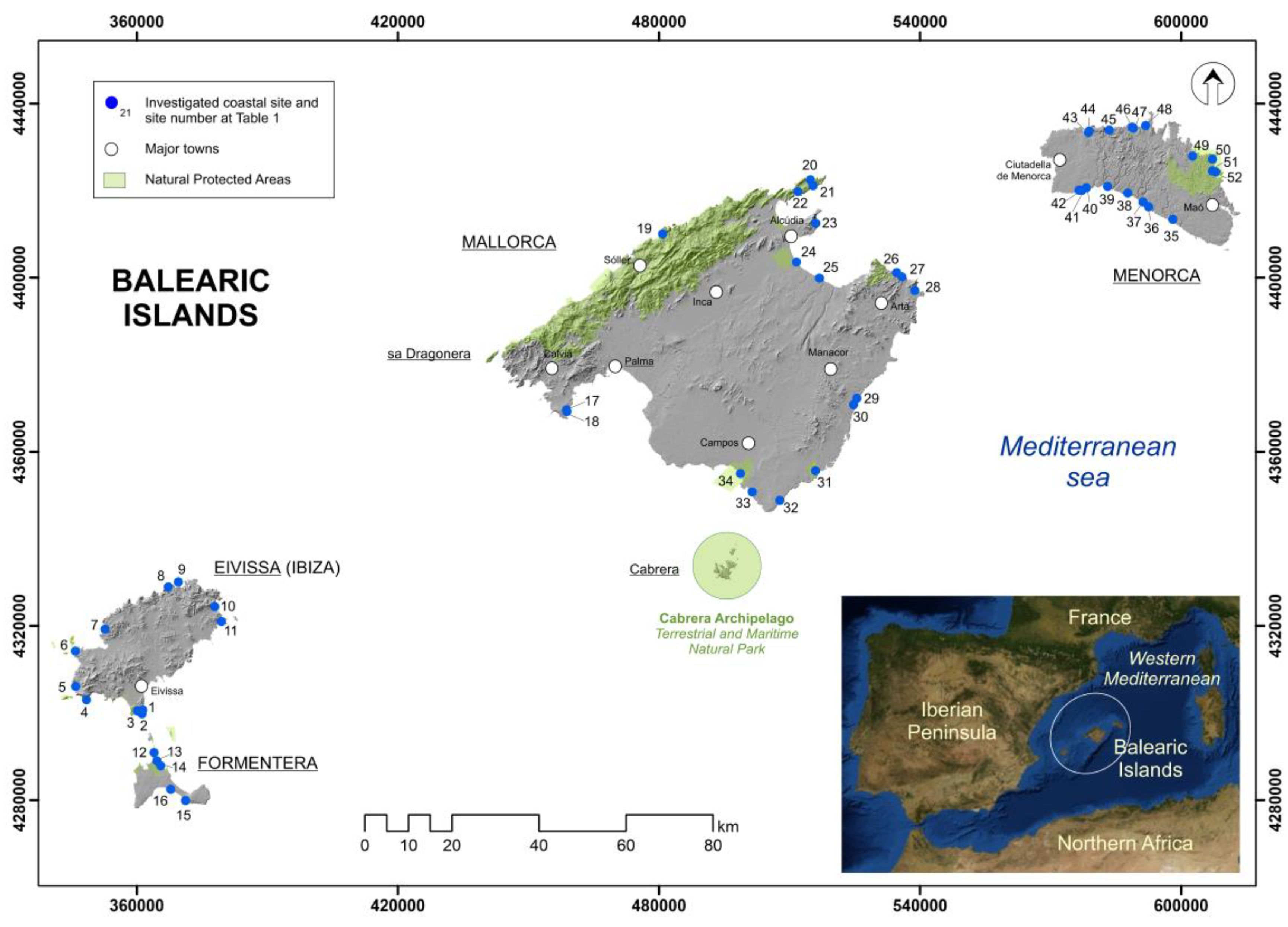
2. Study Area
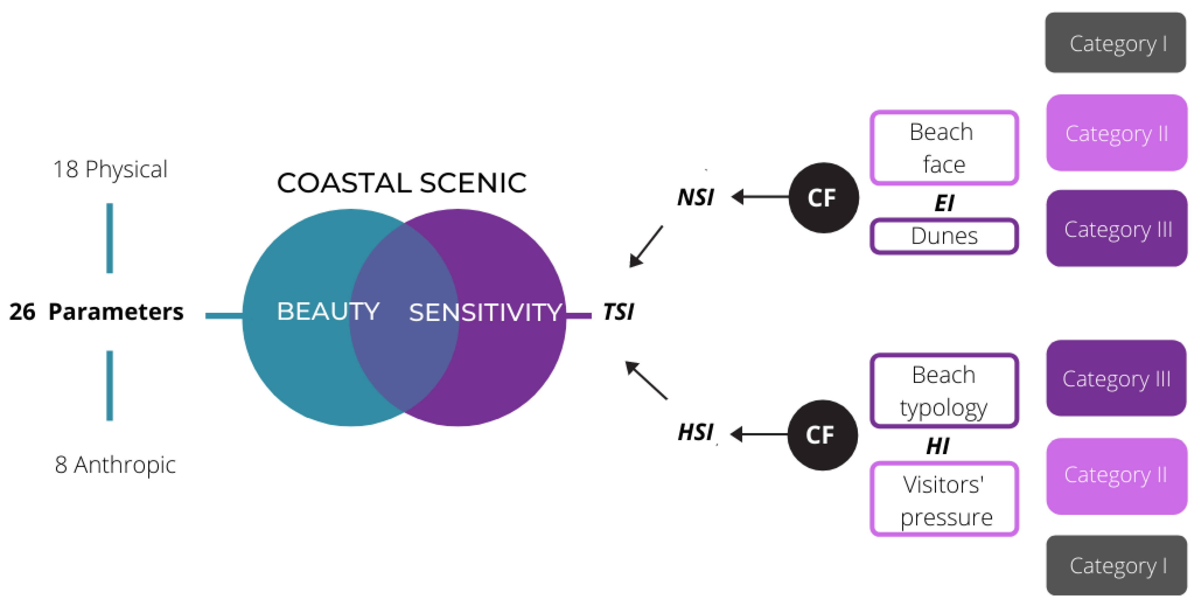
3. Methods
- (i)
- The intrinsic sensitivity of coastal scenic natural parameters indexes (Table 1) to erosion/flooding processes in a scenario of increasing coastal energy linked to climate change, and
- (ii)
- Human parameters indexes (Table 1) sensitivity to human pressure/activities in a scenario of increasing visitor pressures and human coastal occupation, according to the level of protection (e.g., natural park, etc.).
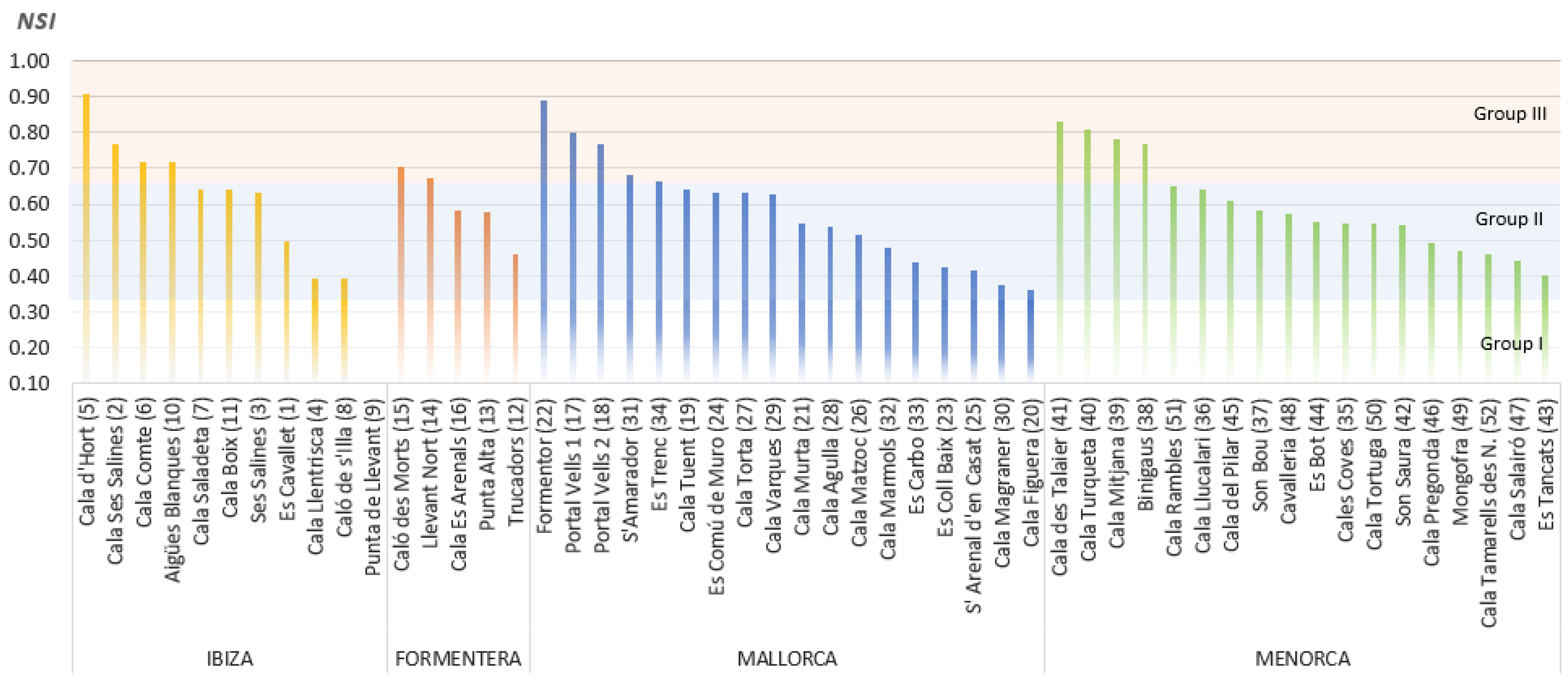
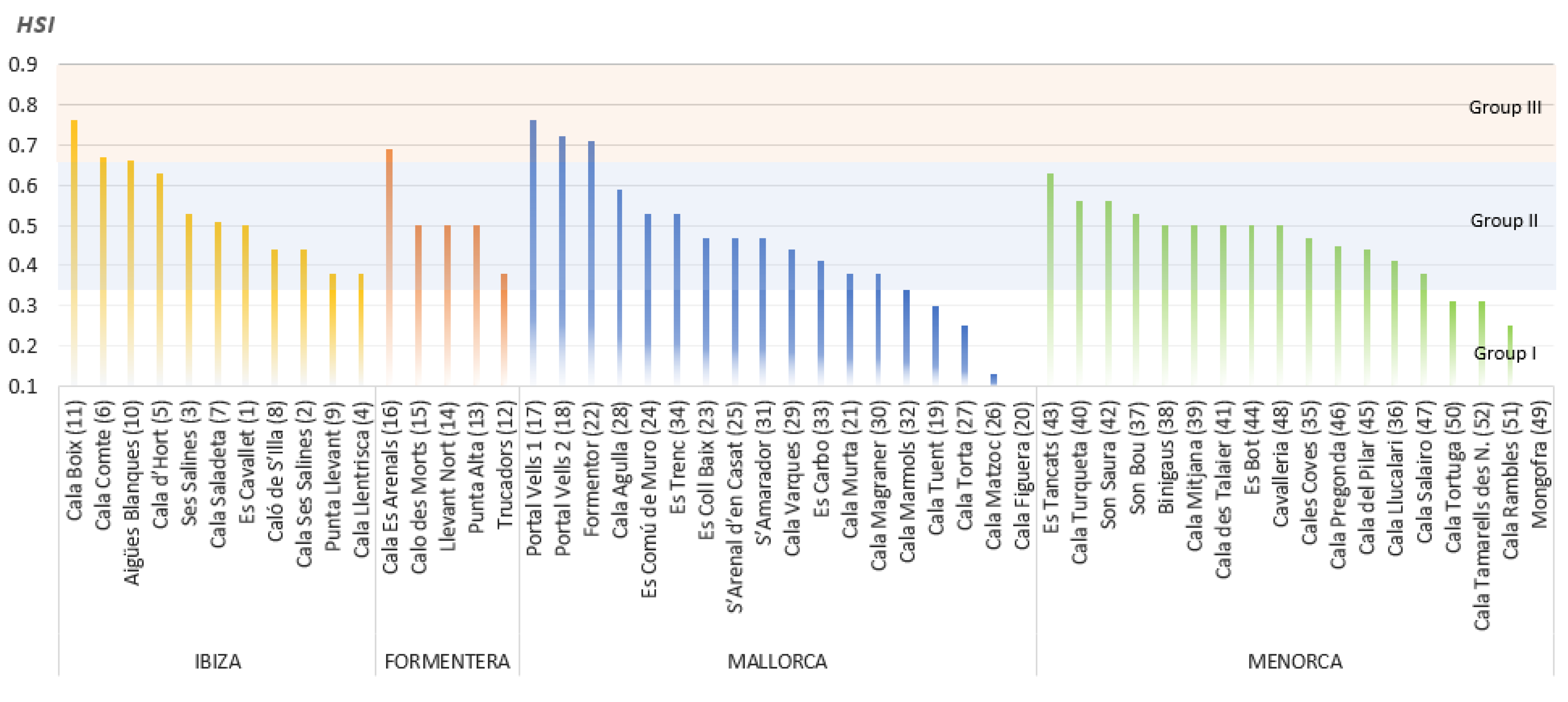
- -
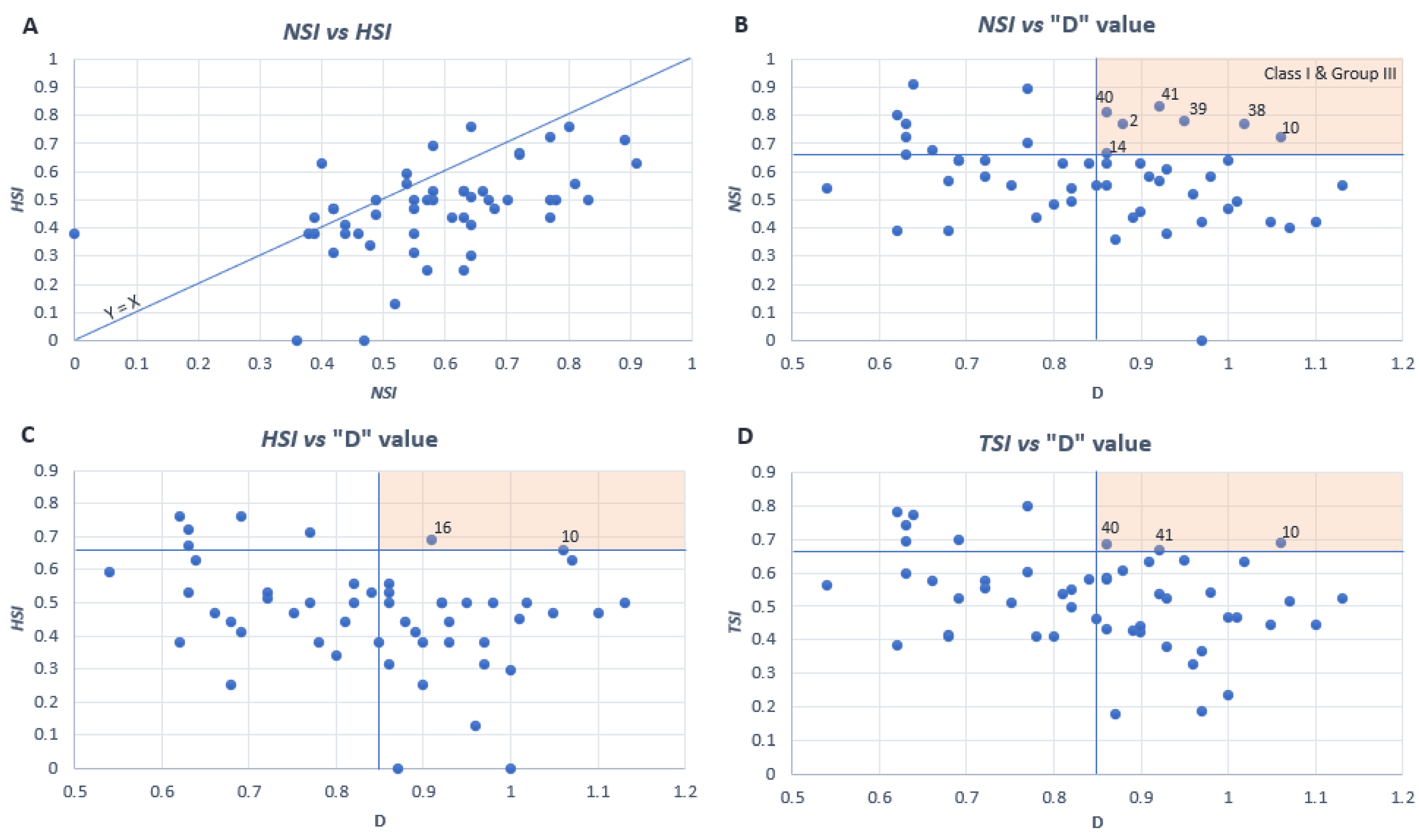
- Group I: NSI < 0.33 (not sensitive);
- -
- Group II: 0.33 ≥ NSI < 0.66 (sensitive);
- -
- Group III: NSI ≥ 0.66 (very sensitive).
4. Protected Areas in the Balearic Islands: Legal Framework and Planning Instruments
- -
- The Spanish coastal law, 2/2013, updated of original law 22/1988 (Ley de Costas in Spanish); Ministry for the Ecological Transition and the Demographic Challenge;
- -
- Counsel of environment and territories (Conselleria de Medi Ambient i Territori in Catalan) and Subunits, among others, general directorates (natural protected areas and biodiversity, landscape and territory), committees and agencies; the regional government of Balearic Islands (Govern Balear);
- -
- Insular councils competencies and departments, e.g., departments of Sostenibilitat i Medi Ambient (Mallorca), Medi Ambient i Reserva Biosfera (Menorca), Presidència i Gestió Ambiental (Ibiza) and Urbanisme i territori, Turisme i Activitats econòmiques (Formentera) in Catalan;
- -
- Territorial planning instruments. Among others, the territorial planning guidelines (Directrices de Ordenacion Territorial DOT in Spanish), insular territorial plans (planes Territoriales Insulares PTI) and master sectorial plans (planes Directores Sectoriales PDS).
5. Results and Discussion
5.1. Coastal Scenic Beauty
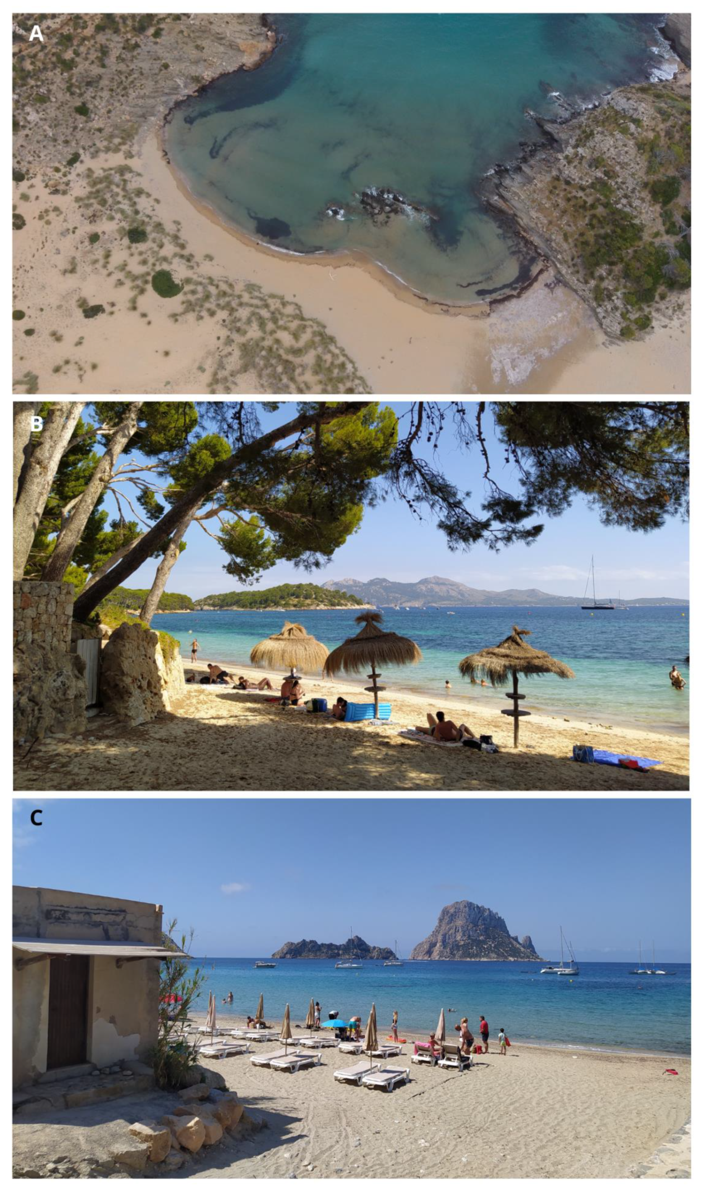
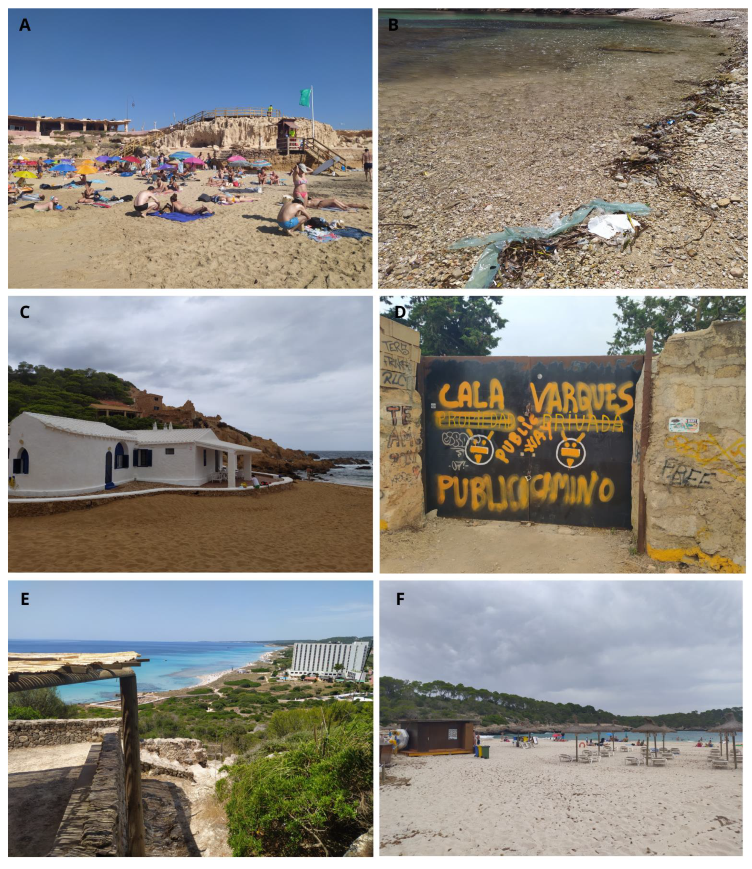
5.1.1. Examples of Investigated Sites
- (a)
- Class I
- (b)
- Class II
- (c)
- Class III
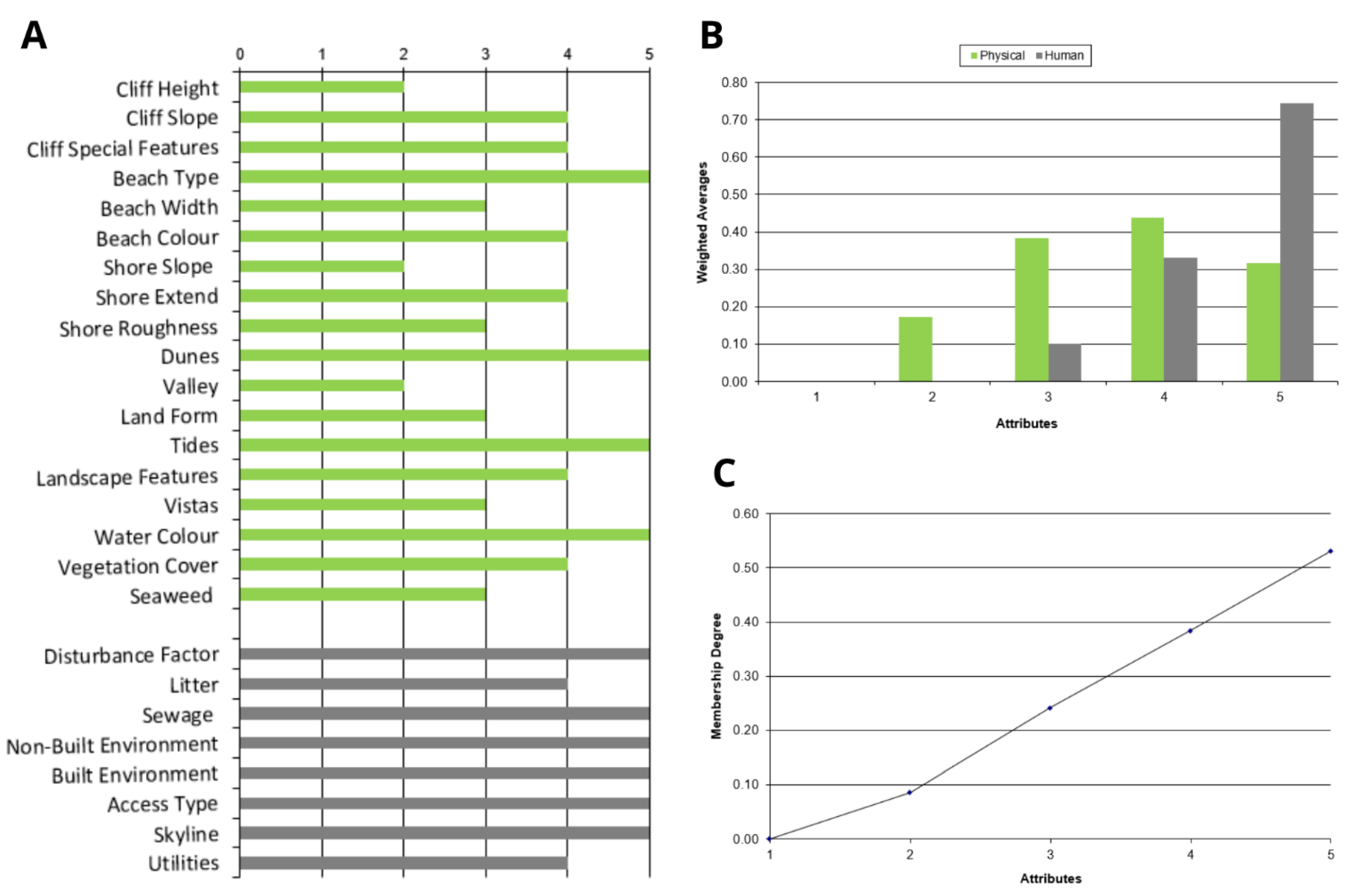
5.1.2. Natural and Human General Sites Characteristics
- (a)
- Physical parameters
- (b)
- Human parameters
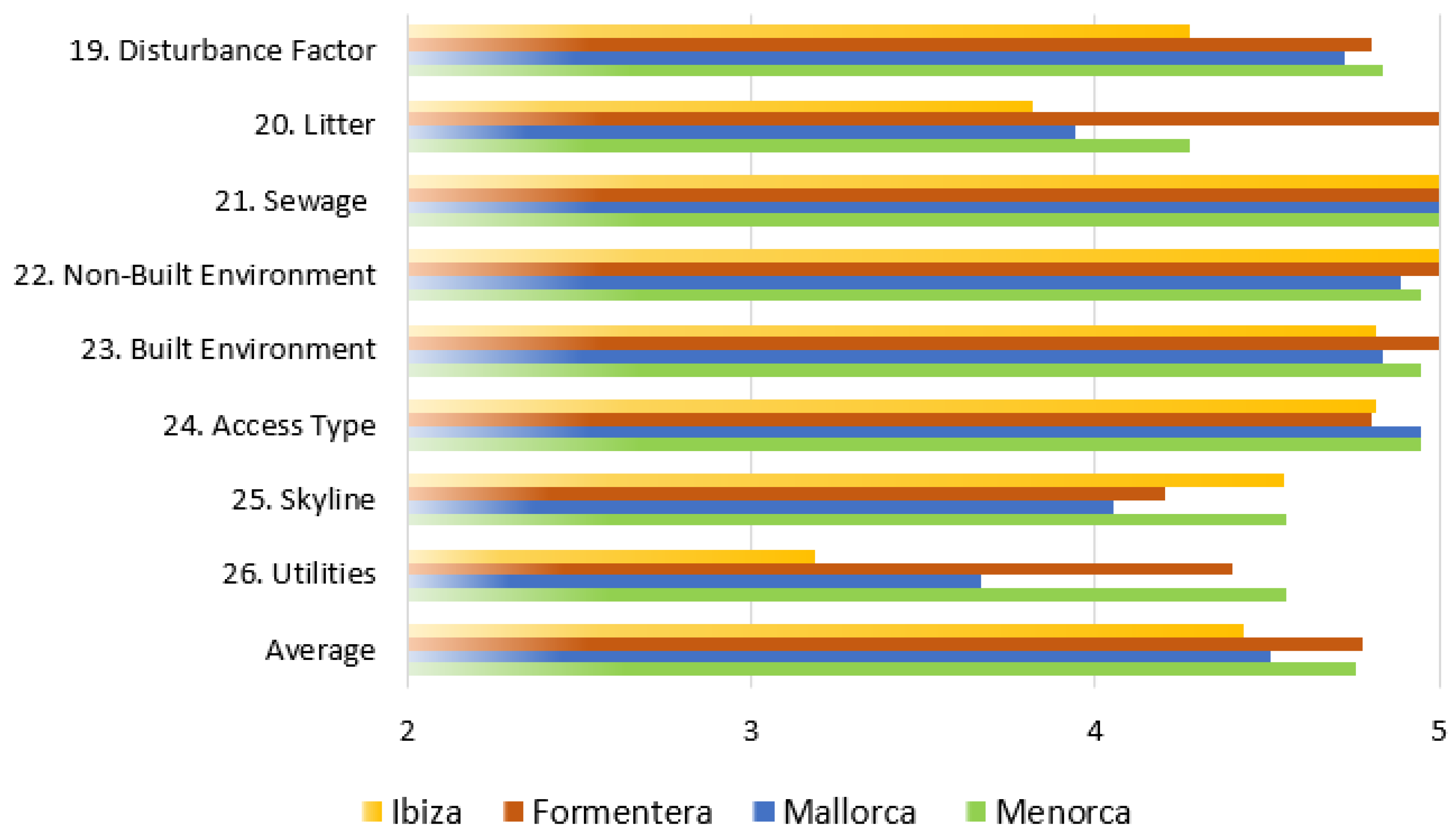
5.1.3. Ratings Analysis and Suggestions for Scenic Enhancement
5.2. Coastal Scenic Sensitivity
5.2.1. Scenic Sensitivity to Natural Processes
5.2.2. Scenic Sensitivity to Human Pressure
5.2.3. Total Sensitivity (TSI) and CSSI Versus CSES
6. Conclusions
Author Contributions
Funding
Institutional Review Board Statement
Informed Consent Statement
Data Availability Statement
Acknowledgments
Conflicts of Interest
Appendix A

| Indexes and Categories | Equations | Parameters |
|---|---|---|
| Erodibility index (1) for category II sites () | : erodibility of beach face parameters : natural parameter : dry beach evolution : sediment grain size : rocky shore width : rocky shore location : number of natural parameters (3) A: maximum attribute value (5) | |
| Erodibility index (2) for category III sites (EIC3) | : erodibility of dune system parameters | |
| Erodibility of dune system (3) () | : dune height : dune width : vegetation cover : washovers | |
| Natural correction factor (4) (CFN) | : significant wave height : angle of wave approach : tidal range : sea-level rise : storm surge | |
| Sensitivity index to natural processes (5) (NSI) | ||
| Human impact index (6) for category II sites ( | Ph: human parameter : access difficulty : protected area management category : tourism intensity rate : population density : number of human parameters A: maximum attribute value (5) | |
| Human impact index (7) for category III sites ( | : beach typology | |
| Human correction factor (8) (CFH) | c: tourism trend | |
| Sensitivity index (9) to human processes (HSI) | ||
| Total sensitivity index (10) (TSI) | ||
| Islands | IBIZA | FORMENTERA | MALLORCA | MENORCA | |||||||||||||||||||||||||||||||||||||||||||||||||
|---|---|---|---|---|---|---|---|---|---|---|---|---|---|---|---|---|---|---|---|---|---|---|---|---|---|---|---|---|---|---|---|---|---|---|---|---|---|---|---|---|---|---|---|---|---|---|---|---|---|---|---|---|---|
| Sites | Es Cavallet (0.82) | Cala Ses Salines (0.88) | Ses Salines (0.84) | Cala Llentrisca (0.62) | Cala d’Hort (0.64) | Cala Conta (0.63) | Cala Saladeta (0.72) | Caló de s’Illa (0.68) | Punta de Llevant (0.97) | Aigües Blanques (1.06) | Cala Boix (0.69) | Punta Alta (0.90) | Pas de n’Adolf (0.98) | Des Trucadors (0.86) | Caló des Morts (0.77) | Cala Es Arenals (0.91) | Portal Vells 1 (0.62) | Portal Vells 2 (0.63) | Cala Tuent (1.00) | Cala Figuera (0.87) | Cala Murta (0.85) | Formentor (0.77) | Es Coll Baix (1.10) | Es Comú de Muro (0.86) | Arenal d’en Casat (1.05) | Cala Matzoc (0.96) | Cala Torta (0.90) | Cala Agulla (0.56) | Cala Varques (0.81) | Cala Magraner (0.93) | S’Amarador (0.66) | Cala Marmols (0.80) | Es Carbo (0.89) | Es Trenc (0.63) | Cales Coves (0.75) | Cala Llucalari (0.69) | Son Bou (0.72) | Binigaus (1.02) | Cala Mitjana (0.95) | Cala Turqueta (0.86) | Cala des Talaier (0.92) | Son Saura (0.82) | Es Tancats (1.07) | Es Bot (1.13) | Cala del Pilar (0.93) | Cala Pregonda (1.01) | Cala Salairó (0.76) | Cavalleria (0.92) | Mongofra (1.00) | Cala Tortuga (0.86) | Cala Rambles (0.68) | Cala Tamarells des N (0.97) | |
| Physical parameters | 1 | 1 | 2 | 1 | 4 | 3 | 2 | 2 | 2 | 2 | 3 | 3 | 1 | 1 | 1 | 2 | 1 | 2 | 2 | 2 | 2 | 3 | 1 | 5 | 1 | 1 | 2 | 2 | 1 | 1 | 2 | 2 | 3 | 1 | 1 | 2 | 3 | 1 | 1 | 3 | 2 | 1 | 1 | 1 | 2 | 3 | 1 | 2 | 2 | 2 | 1 | 1 | 1 |
| 2 | 1 | 4 | 1 | 4 | 4 | 3 | 4 | 4 | 5 | 4 | 3 | 1 | 1 | 1 | 4 | 1 | 3 | 3 | 3 | 4 | 3 | 1 | 3 | 1 | 1 | 3 | 5 | 1 | 1 | 5 | 3 | 4 | 1 | 1 | 5 | 3 | 1 | 1 | 3 | 5 | 1 | 1 | 1 | 3 | 3 | 1 | 4 | 3 | 4 | 1 | 1 | 1 | |
| 3 | 1 | 5 | 1 | 5 | 3 | 4 | 4 | 5 | 4 | 5 | 4 | 1 | 1 | 1 | 5 | 1 | 3 | 3 | 2 | 4 | 3 | 1 | 4 | 1 | 1 | 4 | 4 | 1 | 1 | 4 | 4 | 5 | 1 | 1 | 5 | 5 | 1 | 1 | 5 | 3 | 1 | 1 | 1 | 3 | 4 | 1 | 4 | 4 | 4 | 1 | 1 | 1 | |
| 4 | 5 | 5 | 5 | 4 | 5 | 5 | 4 | 4 | 1 | 5 | 5 | 5 | 5 | 5 | 5 | 5 | 5 | 5 | 4 | 3 | 3 | 5 | 4 | 5 | 5 | 5 | 5 | 5 | 4 | 3 | 5 | 4 | 5 | 5 | 2 | 3 | 5 | 5 | 5 | 5 | 5 | 5 | 5 | 5 | 5 | 5 | 5 | 5 | 5 | 5 | 5 | 5 | |
| 5 | 4 | 3 | 3 | 2 | 3 | 2 | 5 | 3 | 1 | 3 | 3 | 3 | 5 | 3 | 2 | 3 | 5 | 3 | 5 | 3 | 3 | 3 | 5 | 3 | 3 | 4 | 5 | 5 | 3 | 5 | 5 | 4 | 4 | 3 | 3 | 3 | 4 | 5 | 5 | 4 | 4 | 3 | 4 | 5 | 4 | 5 | 5 | 3 | 3 | 3 | 2 | 3 | |
| 6 | 5 | 5 | 5 | 4 | 4 | 5 | 4 | 4 | 1 | 4 | 2 | 5 | 5 | 5 | 5 | 5 | 5 | 4 | 3 | 4 | 4 | 5 | 3 | 4 | 4 | 3 | 5 | 5 | 4 | 3 | 5 | 4 | 5 | 5 | 3 | 4 | 5 | 4 | 5 | 5 | 5 | 5 | 4 | 4 | 4 | 4 | 4 | 4 | 4 | 4 | 3 | 3 | |
| 7 | 1 | 4 | 2 | 1 | 1 | 2 | 4 | 1 | 4 | 1 | 1 | 4 | 5 | 4 | 5 | 5 | 4 | 4 | 1 | 1 | 1 | 1 | 4 | 1 | 3 | 1 | 3 | 2 | 4 | 1 | 1 | 1 | 1 | 2 | 1 | 1 | 2 | 1 | 1 | 3 | 5 | 3 | 2 | 1 | 1 | 1 | 1 | 2 | 2 | 1 | 1 | 5 | |
| 8 | 1 | 5 | 3 | 1 | 1 | 3 | 1 | 1 | 5 | 1 | 1 | 3 | 5 | 5 | 5 | 5 | 5 | 3 | 1 | 1 | 1 | 1 | 3 | 1 | 5 | 1 | 4 | 3 | 5 | 1 | 1 | 1 | 1 | 3 | 1 | 1 | 4 | 1 | 1 | 3 | 5 | 3 | 5 | 1 | 1 | 1 | 1 | 5 | 4 | 1 | 1 | 5 | |
| 9 | 1 | 3 | 5 | 1 | 1 | 5 | 1 | 1 | 4 | 1 | 1 | 3 | 3 | 3 | 4 | 3 | 4 | 3 | 1 | 1 | 1 | 1 | 3 | 1 | 3 | 1 | 3 | 3 | 3 | 1 | 1 | 1 | 1 | 5 | 1 | 1 | 3 | 1 | 1 | 2 | 3 | 3 | 3 | 1 | 1 | 1 | 1 | 3 | 3 | 1 | 1 | 3 | |
| 10 | 5 | 1 | 5 | 1 | 1 | 1 | 1 | 1 | 1 | 1 | 1 | 3 | 1 | 4 | 1 | 3 | 1 | 1 | 1 | 1 | 1 | 1 | 1 | 5 | 5 | 2 | 3 | 4 | 1 | 1 | 5 | 3 | 5 | 5 | 1 | 1 | 5 | 4 | 4 | 3 | 1 | 5 | 5 | 5 | 4 | 4 | 5 | 5 | 5 | 4 | 4 | 3 | |
| 11 | 1 | 1 | 1 | 2 | 1 | 1 | 1 | 2 | 1 | 1 | 1 | 1 | 1 | 1 | 1 | 1 | 2 | 1 | 3 | 2 | 3 | 1 | 1 | 1 | 1 | 1 | 2 | 1 | 2 | 4 | 2 | 2 | 1 | 1 | 1 | 1 | 1 | 2 | 2 | 1 | 1 | 1 | 1 | 4 | 2 | 1 | 1 | 1 | 2 | 1 | 1 | 1 | |
| 12 | 4 | 1 | 4 | 4 | 1 | 1 | 1 | 4 | 4 | 4 | 4 | 3 | 3 | 3 | 1 | 3 | 3 | 3 | 5 | 5 | 4 | 4 | 1 | 4 | 4 | 4 | 4 | 1 | 3 | 1 | 3 | 3 | 2 | 2 | 1 | 1 | 3 | 3 | 3 | 1 | 1 | 2 | 4 | 3 | 4 | 4 | 1 | 1 | 3 | 3 | 3 | 3 | |
| 13 | 5 | 5 | 5 | 5 | 5 | 5 | 5 | 5 | 5 | 5 | 5 | 5 | 5 | 5 | 5 | 5 | 5 | 5 | 5 | 5 | 5 | 5 | 5 | 5 | 5 | 5 | 5 | 5 | 5 | 5 | 5 | 5 | 5 | 5 | 5 | 5 | 5 | 5 | 5 | 5 | 5 | 5 | 5 | 5 | 5 | 5 | 5 | 5 | 5 | 5 | 5 | 5 | |
| 14 | 1 | 3 | 3 | 3 | 4 | 4 | 3 | 3 | 3 | 4 | 3 | 4 | 4 | 3 | 4 | 3 | 4 | 3 | 4 | 4 | 3 | 5 | 4 | 3 | 3 | 3 | 3 | 3 | 3 | 3 | 3 | 4 | 4 | 3 | 3 | 3 | 3 | 3 | 4 | 3 | 3 | 3 | 4 | 3 | 3 | 5 | 5 | 4 | 4 | 3 | 3 | 4 | |
| 15 | 4 | 1 | 4 | 2 | 3 | 4 | 1 | 2 | 4 | 4 | 3 | 5 | 4 | 4 | 1 | 4 | 2 | 1 | 3 | 3 | 3 | 3 | 3 | 4 | 4 | 3 | 3 | 3 | 3 | 1 | 2 | 1 | 4 | 4 | 1 | 3 | 4 | 4 | 3 | 1 | 1 | 3 | 3 | 3 | 3 | 3 | 1 | 3 | 3 | 3 | 3 | 3 | |
| 16 | 5 | 5 | 5 | 5 | 5 | 5 | 5 | 5 | 5 | 5 | 5 | 5 | 5 | 5 | 5 | 5 | 5 | 5 | 5 | 4 | 5 | 5 | 5 | 5 | 5 | 5 | 5 | 5 | 5 | 5 | 5 | 5 | 5 | 5 | 5 | 5 | 5 | 5 | 5 | 5 | 5 | 5 | 5 | 5 | 5 | 5 | 5 | 5 | 5 | 5 | 5 | 5 | |
| 17 | 3 | 3 | 5 | 5 | 3 | 2 | 5 | 4 | 2 | 3 | 4 | 3 | 1 | 3 | 1 | 3 | 5 | 5 | 5 | 3 | 5 | 5 | 4 | 4 | 4 | 5 | 4 | 5 | 5 | 4 | 5 | 5 | 5 | 4 | 5 | 3 | 3 | 5 | 5 | 5 | 4 | 5 | 3 | 4 | 3 | 4 | 3 | 3 | 4 | 4 | 5 | 4 | |
| 18 | 1 | 4 | 3 | 1 | 4 | 3 | 3 | 1 | 5 | 4 | 2 | 1 | 3 | 1 | 1 | 4 | 3 | 4 | 1 | 1 | 2 | 4 | 3 | 1 | 1 | 1 | 3 | 1 | 1 | 1 | 3 | 1 | 1 | 1 | 1 | 1 | 4 | 3 | 1 | 3 | 3 | 1 | 4 | 5 | 3 | 4 | 3 | 3 | 3 | 1 | 1 | 1 | |
| Human parameters | 19 | 4 | 4 | 4 | 5 | 4 | 3 | 4 | 5 | 5 | 4 | 4 | 5 | 5 | 5 | 4 | 5 | 4 | 5 | 5 | 5 | 5 | 4 | 5 | 5 | 5 | 5 | 5 | 4 | 5 | 5 | 4 | 5 | 5 | 4 | 5 | 5 | 5 | 5 | 4 | 4 | 5 | 5 | 4 | 5 | 5 | 5 | 5 | 5 | 5 | 5 | 5 | 5 |
| 20 | 4 | 5 | 4 | 1 | 4 | 4 | 4 | 3 | 5 | 4 | 4 | 5 | 5 | 5 | 5 | 5 | 4 | 4 | 4 | 4 | 4 | 4 | 4 | 4 | 4 | 4 | 4 | 4 | 4 | 4 | 4 | 3 | 4 | 4 | 5 | 4 | 5 | 5 | 4 | 4 | 5 | 5 | 5 | 5 | 4 | 4 | 3 | 4 | 4 | 4 | 3 | 4 | |
| 21 | 5 | 5 | 5 | 5 | 5 | 5 | 5 | 5 | 5 | 5 | 5 | 5 | 5 | 5 | 5 | 5 | 5 | 5 | 5 | 5 | 5 | 5 | 5 | 5 | 5 | 5 | 5 | 5 | 5 | 5 | 5 | 5 | 5 | 5 | 5 | 5 | 5 | 5 | 5 | 5 | 5 | 5 | 5 | 5 | 5 | 5 | 5 | 5 | 5 | 5 | 5 | 5 | |
| 22 | 5 | 5 | 5 | 5 | 5 | 5 | 5 | 5 | 5 | 5 | 5 | 5 | 5 | 5 | 5 | 5 | 5 | 5 | 5 | 5 | 5 | 3 | 5 | 5 | 5 | 5 | 5 | 5 | 5 | 5 | 5 | 5 | 5 | 5 | 5 | 5 | 5 | 4 | 5 | 5 | 5 | 5 | 5 | 5 | 5 | 5 | 5 | 5 | 5 | 5 | 5 | 5 | |
| 23 | 5 | 5 | 5 | 5 | 4 | 4 | 5 | 5 | 5 | 5 | 5 | 5 | 5 | 5 | 5 | 5 | 4 | 5 | 5 | 5 | 4 | 4 | 5 | 5 | 5 | 5 | 5 | 5 | 5 | 5 | 5 | 5 | 5 | 5 | 5 | 5 | 5 | 5 | 5 | 5 | 5 | 5 | 5 | 5 | 5 | 4 | 5 | 5 | 5 | 5 | 5 | 5 | |
| 24 | 5 | 5 | 5 | 5 | 4 | 5 | 4 | 5 | 5 | 5 | 5 | 5 | 5 | 5 | 5 | 4 | 5 | 5 | 4 | 5 | 5 | 5 | 5 | 5 | 5 | 5 | 5 | 5 | 5 | 5 | 5 | 5 | 5 | 5 | 5 | 5 | 5 | 5 | 5 | 5 | 5 | 5 | 5 | 5 | 5 | 4 | 5 | 5 | 5 | 5 | 5 | 5 | |
| 25 | 4 | 5 | 4 | 5 | 4 | 5 | 4 | 5 | 5 | 4 | 5 | 4 | 4 | 4 | 5 | 4 | 3 | 3 | 4 | 5 | 4 | 4 | 5 | 3 | 4 | 5 | 5 | 3 | 5 | 5 | 4 | 5 | 3 | 3 | 4 | 5 | 2 | 5 | 5 | 4 | 4 | 4 | 5 | 5 | 5 | 5 | 4 | 5 | 5 | 5 | 5 | 5 | |
| 26 | 4 | 5 | 2 | 4 | 1 | 1 | 3 | 4 | 5 | 4 | 1 | 4 | 5 | 4 | 5 | 4 | 1 | 4 | 4 | 5 | 4 | 2 | 5 | 4 | 5 | 5 | 3 | 3 | 4 | 5 | 1 | 5 | 5 | 3 | 5 | 5 | 4 | 5 | 4 | 5 | 5 | 4 | 4 | 5 | 5 | 3 | 5 | 4 | 4 | 5 | 5 | 5 | |
| Sites | Islands | Category | Dry Beach | Sediment | RS Width | RS Location | D. Heigh | D. Width | Veg. Cover | Washovers | EI | Hs | Angle of W. | Tidal Range | SLR | SS | NSI | Group |
|---|---|---|---|---|---|---|---|---|---|---|---|---|---|---|---|---|---|---|
| 1. Es Cavallet | Ibiza | III | 1 | 4 | 5 | 5 | 2 | 2 | 2 | 2 | 0.58 | 3 | 1 | 5 | 5 | 1 | 0.49 | II |
| 2. Cala Ses Salines | II | 5 | 5 | 4 | 1 | 0.79 | 3 | 5 | 5 | 5 | 1 | 0.77 | III | |||||
| 3. Ses Salines | III | 5 | 5 | 5 | 3 | 1 | 1 | 1 | 1 | 0.92 | 3 | 5 | 5 | 5 | 1 | 0.63 | II | |
| 4. Cala Llentrisca | II | 1 | 1 | 5 | 5 | 0.33 | 3 | 1 | 5 | 5 | 1 | 0.39 | II | |||||
| 5. Cala d’Hort | II | 5 | 5 | 5 | 5 | 1.00 | 3 | 3 | 5 | 5 | 1 | 0.91 | III | |||||
| 6. Cala Comte | II | 4 | 5 | 4 | 2 | 0.75 | 3 | 3 | 5 | 5 | 1 | 0.72 | III | |||||
| 7. Cala Saladeta | II | 1 | 5 | 5 | 5 | 0.67 | 3 | 1 | 5 | 5 | 1 | 0.64 | II | |||||
| 8. Caló de S’Illa | II | 1 | 1 | 5 | 5 | 0.33 | 3 | 1 | 5 | 5 | 1 | 0.39 | II | |||||
| 9. Punta de Llevant | I | I | ||||||||||||||||
| 10. Aigües Blanques | II | 2 | 5 | 5 | 5 | 0.75 | 3 | 3 | 5 | 5 | 1 | 0.72 | III | |||||
| 11. Cala Boix | II | 1 | 5 | 5 | 5 | 0.67 | 3 | 1 | 5 | 5 | 1 | 0.64 | II | |||||
| 12. Punta Alta | Formentera | III | 1 | 4 | 5 | 1 | 2 | 3 | 3 | 2 | 0.42 | 3 | 3 | 5 | 5 | 1 | 0.46 | II |
| 13. Pas de n’Adolf | II | 1 | 5 | 4 | 3 | 0.54 | 3 | 5 | 5 | 5 | 1 | 0.58 | II | |||||
| 14. Des Trucadors | III | 5 | 5 | 4 | 3 | 2 | 2 | 2 | 2 | 0.88 | 3 | 5 | 5 | 5 | 1 | 0.67 | III | |
| 15. Caló des Morts | II | 5 | 4 | 4 | 1 | 0.71 | 3 | 5 | 5 | 5 | 1 | 0.70 | III | |||||
| 16. Cala Es Arenals | III | 1 | 5 | 4 | 3 | 3 | 4 | 3 | 3 | 0.54 | 3 | 5 | 5 | 5 | 1 | 0.58 | II | |
| 17. Portal Vells 1 | Mallorca | II | 5 | 5 | 4 | 3 | 0.88 | 3 | 1 | 5 | 5 | 1 | 0.80 | III | ||||
| 18. Portal Vells 2 | II | 4 | 5 | 5 | 3 | 0.83 | 3 | 1 | 5 | 5 | 1 | 0.77 | III | |||||
| 19. Cala Tuent | II | 5 | 1 | 5 | 5 | 0.67 | 3 | 1 | 5 | 5 | 1 | 0.64 | II | |||||
| 20. Cala Figuera | II | 1 | 1 | 4 | 4 | 0.25 | 3 | 5 | 5 | 5 | 1 | 0.36 | II | |||||
| 21. Cala Murta | II | 4 | 1 | 5 | 4 | 0.54 | 3 | 1 | 5 | 5 | 1 | 0.55 | II | |||||
| 22. Formentor | II | 5 | 5 | 5 | 5 | 1.00 | 3 | 1 | 5 | 5 | 1 | 0.89 | III | |||||
| 23. Es Coll Baix | II | 1 | 1 | 5 | 5 | 0.33 | 3 | 5 | 5 | 5 | 1 | 0.42 | II | |||||
| 24. Es Comú de Muro | III | 4 | 5 | 5 | 5 | 1 | 1 | 1 | 1 | 0.92 | 3 | 5 | 5 | 5 | 1 | 0.63 | II | |
| 25. S’Arenal d’en Casat | III | 1 | 4 | 4 | 3 | 2 | 1 | 1 | 1 | 0.46 | 3 | 5 | 5 | 5 | 1 | 0.42 | II | |
| 26. Cala Matzoc | II | 1 | 3 | 5 | 5 | 0.50 | 3 | 1 | 5 | 5 | 1 | 0.52 | II | |||||
| 27. Cala Torta | III | 1 | 5 | 5 | 5 | 2 | 3 | 3 | 4 | 0.67 | 3 | 5 | 5 | 5 | 1 | 0.63 | II | |
| 28. Cala Agulla | III | 1 | 5 | 5 | 5 | 1 | 2 | 1 | 3 | 0.67 | 3 | 3 | 5 | 5 | 1 | 0.54 | II | |
| 29. Cala Varques | II | 1 | 5 | 5 | 5 | 0.67 | 1 | 1 | 5 | 5 | 1 | 0.63 | II | |||||
| 30. Cala Magraner | II | 1 | 1 | 5 | 5 | 0.33 | 1 | 1 | 5 | 5 | 1 | 0.38 | II | |||||
| 31. S’Amarador | III | 3 | 5 | 5 | 5 | 3 | 3 | 3 | 3 | 0.83 | 3 | 1 | 5 | 5 | 1 | 0.68 | III | |
| 32. Cala Marmols | III | 1 | 1 | 5 | 5 | 3 | 5 | 3 | 4 | 0.33 | 3 | 1 | 5 | 5 | 1 | 0.48 | II | |
| 33. Es Carbo | III | 1 | 3 | 5 | 5 | 1 | 1 | 1 | 2 | 0.50 | 3 | 5 | 5 | 5 | 1 | 0.44 | II | |
| 34. Es Trenc | III | 5 | 4 | 5 | 5 | 2 | 1 | 1 | 2 | 0.92 | 3 | 5 | 5 | 5 | 1 | 0.66 | III | |
| 35. Cales Coves | Menorca | II | 2 | 3 | 5 | 4 | 0.54 | 3 | 1 | 5 | 5 | 1 | 0.55 | II | ||||
| 36. Cala Llucalari | II | 5 | 1 | 5 | 5 | 0.67 | 1 | 3 | 5 | 5 | 1 | 0.64 | II | |||||
| 37. Son Bou | III | 4 | 5 | 4 | 3 | 2 | 2 | 1 | 1 | 0.79 | 1 | 5 | 5 | 5 | 1 | 0.58 | II | |
| 38. Binigaus | III | 5 | 5 | 5 | 5 | 2 | 3 | 2 | 4 | 1.00 | 1 | 5 | 5 | 5 | 1 | 0.77 | III | |
| 39. Cala Mitjana | III | 5 | 5 | 5 | 5 | 3 | 4 | 2 | 4 | 1.00 | 1 | 3 | 5 | 5 | 1 | 0.78 | III | |
| 40. Cala Turqueta | III | 4 | 5 | 4 | 4 | 5 | 5 | 5 | 5 | 0.83 | 3 | 1 | 5 | 5 | 1 | 0.81 | III | |
| 41. Cala des Talaier | II | 5 | 5 | 4 | 4 | 0.92 | 3 | 1 | 5 | 5 | 1 | 0.83 | III | |||||
| 42. Son Saura | III | 4 | 3 | 4 | 5 | 2 | 1 | 1 | 1 | 0.71 | 3 | 5 | 5 | 5 | 1 | 0.54 | II | |
| 43. Es Tancats | III | 1 | 5 | 4 | 1 | 1 | 1 | 1 | 1 | 0.46 | 5 | 3 | 5 | 5 | 1 | 0.40 | II | |
| 44. Es Bot | III | 1 | 5 | 5 | 5 | 2 | 2 | 1 | 3 | 0.67 | 5 | 1 | 5 | 5 | 1 | 0.55 | II | |
| 45. Cala del Pilar | III | 2 | 5 | 5 | 5 | 2 | 2 | 2 | 1 | 0.75 | 5 | 5 | 5 | 5 | 1 | 0.61 | II | |
| 46. Cala Pregonda | III | 2 | 5 | 3 | 1 | 2 | 4 | 1 | 2 | 0.50 | 5 | 2 | 5 | 5 | 1 | 0.49 | II | |
| 47. Cala Salairó | III | 1 | 5 | 3 | 1 | 1 | 1 | 2 | 4 | 0.42 | 5 | 3 | 5 | 5 | 1 | 0.44 | II | |
| 48. Cavalleria | III | 4 | 5 | 4 | 1 | 2 | 2 | 2 | 1 | 0.71 | 5 | 3 | 5 | 5 | 1 | 0.57 | II | |
| 49. Mongofra | III | 3 | 5 | 4 | 1 | 1 | 1 | 1 | 2 | 0.63 | 3 | 1 | 5 | 5 | 1 | 0.47 | II | |
| 50. Cala Tortuga | III | 4 | 3 | 5 | 5 | 2 | 2 | 1 | 1 | 0.75 | 3 | 1 | 5 | 5 | 1 | 0.55 | II | |
| 51. Cala Rambles | III | 3 | 3 | 5 | 5 | 3 | 2 | 1 | 3 | 0.83 | 3 | 3 | 5 | 5 | 1 | 0.57 | II | |
| 52. Cala Tamarells des N. | III | 1 | 3 | 3 | 3 | 4 | 4 | 2 | 1 | 0.42 | 3 | 1 | 5 | 5 | 1 | 0.42 | II |
| Sites | Municipalities | Islands | Category | Access | PAMC | TIR | PD | Typology | HI | CF | HSI | Group |
|---|---|---|---|---|---|---|---|---|---|---|---|---|
| 1. Es Cavallet | San Josep de Sa Talaia | Ibiza | II | 3 | 3 | 5 | 3 | 0.58 | 2 | 0.50 | II | |
| 2. Cala Ses Salines | II | 2 | 3 | 5 | 3 | 0.50 | 2 | 0.44 | II | |||
| 3. Ses Salines | III | 4 | 3 | 5 | 3 | 3 | 0.63 | 2 | 0.53 | II | ||
| 4. Cala Llentrisca | II | 1 | 3 | 5 | 3 | 0.42 | 2 | 0.38 | II | |||
| 5. Cala d’Hort | III | 5 | 3 | 5 | 3 | 4 | 0.75 | 2 | 0.63 | II | ||
| 6. Cala Comte | III | 5 | 4 | 5 | 3 | 4 | 0.81 | 2 | 0.67 | III | ||
| 7. Cala Saladeta | San Antoni de P. | III | 3 | 4 | 4 | 3 | 3 | 0.59 | 2 | 0.51 | II | |
| 8. Caló de S’Illa | Sant Joan de Labritja | II | 2 | 3 | 5 | 1 | 0.42 | 3 | 0.44 | II | ||
| 9. Punta de Llevant | II | 1 | 3 | 5 | 1 | 0.33 | 3 | 0.38 | II | |||
| 10. Aigües Blanques | Santa Eularia des Riu | II | 4 | 4 | 4 | 3 | 0.71 | 3 | 0.66 | III | ||
| 11. Cala Boix | III | 5 | 4 | 4 | 3 | 5 | 0.84 | 3 | 0.76 | III | ||
| 12. Punta Alta | Formentera | Formentera | II | 1 | 3 | 4 | 2 | 0.33 | 3 | 0.38 | II | |
| 13. Pas de n’Adolf | II | 3 | 3 | 4 | 2 | 0.50 | 3 | 0.50 | II | |||
| 14. Des Trucadors | II | 3 | 3 | 4 | 2 | 0.50 | 3 | 0.50 | II | |||
| 15. Caló des Morts | II | 3 | 3 | 4 | 2 | 0.50 | 3 | 0.50 | II | |||
| 16. Cala Es Arenals | II | 5 | 4 | 4 | 2 | 0.75 | 3 | 0.69 | III | |||
| 17. Portal Vells 1 | Calvia | Mallorca | III | 5 | 4 | 5 | 4 | 4 | 0.84 | 3 | 0.76 | III |
| 18. Portal Vells 2 | II | 4 | 4 | 5 | 4 | 0.79 | 3 | 0.72 | III | |||
| 19. Cala Tuent | Escorca | III | 3 | 2 | 1 | 1 | 3 | 0.31 | 2 | 0.30 | I | |
| 20. Cala Figuera | Pollença | category I | ||||||||||
| 21. Cala Murta | III | 2 | 2 | 3 | 2 | 3 | 0.34 | 3 | 0.38 | II | ||
| 22. Formentor | III | 4 | 5 | 3 | 2 | 5 | 0.78 | 3 | 0.71 | III | ||
| 23. Es Coll Baix | Alcudia | II | 1 | 3 | 5 | 4 | 0.46 | 3 | 0.47 | II | ||
| 24. Es Comú de Muro | Muro | II | 3 | 3 | 5 | 2 | 0.54 | 3 | 0.53 | II | ||
| 25. S’Arenal d’en Casat | Santa Margalida | II | 2 | 3 | 5 | 2 | 0.46 | 3 | 0.47 | II | ||
| 26. Cala Matzoc | Arta | II | 1 | 3 | 5 | 1 | 0.33 | 1 | 0.13 | I | ||
| 27. Cala Torta | II | 3 | 3 | 5 | 1 | 0.50 | 1 | 0.25 | I | |||
| 28. Cala Agulla | Capdepera | III | 4 | 3 | 5 | 3 | 3 | 0.63 | 3 | 0.59 | II | |
| 29. Cala Varques | Manacor | II | 2 | 3 | 3 | 3 | 0.42 | 3 | 0.44 | II | ||
| 30. Cala Magraner | II | 1 | 3 | 3 | 3 | 0.33 | 3 | 0.38 | II | |||
| 31. S’Amarador | Santanyi | II | 3 | 3 | 5 | 2 | 0.54 | 2 | 0.47 | II | ||
| 32. Cala Marmols | II | 1 | 3 | 5 | 2 | 0.38 | 2 | 0.34 | II | |||
| 33. Es Carbo | Ses Salines | II | 2 | 3 | 5 | 2 | 0.46 | 2 | 0.41 | II | ||
| 34. Es Trenc | Campos | II | 3 | 3 | 1 | 2 | 0.38 | 5 | 0.53 | II | ||
| 35. Cales Coves | Alaior | Menorca | II | 3 | 3 | 5 | 2 | 0.54 | 2 | 0.47 | II | |
| 36. Cala Llucalari | II | 1 | 3 | 5 | 2 | 0.38 | 3 | 0.41 | II | |||
| 37. Son Bou | II | 3 | 3 | 5 | 2 | 0.54 | 3 | 0.53 | II | |||
| 38. Binigaus | Es Migjorn Gran | II | 3 | 3 | 5 | 1 | 0.50 | 3 | 0.50 | II | ||
| 39. Cala Mitjana | Ferreries | II | 3 | 3 | 2 | 2 | 0.42 | 4 | 0.50 | II | ||
| 40. Cala Turqueta | Ciutadella de Menorca | II | 3 | 3 | 5 | 3 | 0.58 | 3 | 0.56 | II | ||
| 41. Cala des Talaier | II | 2 | 3 | 5 | 3 | 0.50 | 3 | 0.50 | II | |||
| 42. Son Saura | II | 3 | 3 | 5 | 3 | 0.58 | 3 | 0.56 | II | |||
| 43. Es Tancats | II | 4 | 3 | 5 | 3 | 0.67 | 3 | 0.63 | II | |||
| 44. Es Bot | II | 2 | 3 | 5 | 3 | 0.50 | 3 | 0.50 | II | |||
| 45. Cala del Pilar | II | 1 | 3 | 5 | 3 | 0.42 | 3 | 0.44 | II | |||
| 46. Cala Pregonda | Es Mercadal | III | 2 | 3 | 5 | 1 | 3 | 0.44 | 3 | 0.45 | II | |
| 47. Cala Salairó | II | 1 | 3 | 5 | 1 | 0.33 | 3 | 0.38 | II | |||
| 48. Cavalleria | II | 3 | 3 | 5 | 1 | 0.50 | 3 | 0.50 | II | |||
| 49. Mongofra | Mahón | category I | ||||||||||
| 50. Cala Tortuga | II | 2 | 2 | 1 | 3 | 0.25 | 3 | 0.31 | I | |||
| 51. Cala Rambles | II | 1 | 2 | 1 | 3 | 0.17 | 3 | 0.25 | I | |||
| 52. Cala Tamarells des N. | II | 2 | 2 | 1 | 3 | 0.25 | 3 | 0.31 | I | |||
References
- Klein, Y.L.; Osleeb, J.P.; Viola, M.R. Tourism generated earnings in the coastal zone: A regional analysis. J. Coast. Res. 2004, 20, 1080–1088. [Google Scholar]
- UNWTO (United Nations World Tourism Organization). Tourism Highlights; UNWTO: Madrid, Spain, 2019. [Google Scholar]
- UNWTO (United Nations World Tourism Organization). European Union Tourism Trends; UNWTO: Madrid, Spain, 2018. [Google Scholar]
- Dodds, R.; Kelman, I. How climate change is considered in sustainable tourism policies: A case of the Mediterranean islands of Malta and Mallorca. Tour. Rev. Int. 2008, 12, 57–70. [Google Scholar] [CrossRef]
- Honey, M.; Krantz, D. Global Trends in Coastal Tourism; Center on Ecotourism and Sustainable Development: Washington, DC, USA, 2007. [Google Scholar]
- Houston, J.R. The economic value of beaches—A 2013 update. Shore Beach 2013, 81, 3–10. [Google Scholar]
- Corbin, A. El Territorio del Vacío. In Occidente y la Invención de la Playa; Editorial Mondadori: Barcelona, Spain, 1993; pp. 1750–1840. [Google Scholar]
- Rubio, D. Gestión Integral de Playas. In Agencia Valenciana de Turismo; Editorial Sintesis: Madrid, Spain, 2005. [Google Scholar]
- Williams, A.; Micallef, A. Beach Management: Principles and Practice, 1st ed.; Earthscan: London, UK, 2009. [Google Scholar]
- Williams, A.T. Definitions and typologies of coastal tourism beach destinations. In Disappearing Destinations: Climate Change and Future Challenges for Coastal Tourism; Jones, A., Phillips, M., Eds.; CABI: Wallingford, UK, 2011; p. 296. [Google Scholar]
- Council of Europe. European Landscape Convention; Council of Europe: Florence, Italy, 2000. [Google Scholar]
- Teale, E.W. Wandering through Winter; Dodd, Mead and Co.: New York, NY, USA, 1965. [Google Scholar]
- Rodella, I.; Madau, F.A.; Carboni, D. The Willingness to Pay for Beach Scenery and its Preservation in Italy. Sustainability 2020, 12, 1620. [Google Scholar] [CrossRef] [Green Version]
- Ergin, A.; Karaesmen, E.; Micallef, A.; Williams, A.T. A new methodology for evaluating coastal scenery: Fuzzy logic systems. Area 2004, 36, 367–386. [Google Scholar] [CrossRef]
- Ergin, A.; Williams, A.T.; Micallef, A. Coastal scenery: Appreciation and evaluation. J. Coast. Res. 2006, 22, 958–964. [Google Scholar] [CrossRef]
- Ergin, A. Coastal Scenery Assessment by Means of a Fuzzy Logic Approach. In Coastal Scenery: Evaluation and Management; Rangel-Buitrago, N., Ed.; Springer: Dordrecht, The Netherlands, 2019; pp. 67–106. [Google Scholar]
- Mooser, A.; Anfuso, G.; Williams, A.T.; Molina, R.; Aucelli, P.P.C. An Innovative Approach to Determine Coastal Scenic Beauty and Sensitivity in a Scenario of Increasing Human Pressure and Natural Impacts due to Climate Change. Water 2021, 13, 49. [Google Scholar] [CrossRef]
- Lozano, I.; Devoy, R.; May, W.; Andersen, U. Storminess and vulnerability along the Atlantic coastlines of Europe: Analysis of storm records and of a greenhouse gases induced climate scenario. Mar. Geol. 2004, 210, 205–225. [Google Scholar] [CrossRef]
- Beudin, A.; Ganju, N.K.; Defne, Z.; Aretxabaleta, A. Physical response of a back-barrier estuary to a post-tropical cyclone. J. Geophys. Res. Ocean. 2017, 122, 5888–5904. [Google Scholar] [CrossRef] [Green Version]
- Anfuso, G.; Loureiro, C.; Taaouati, M.; Smyth, T.; Jackson, D. Spatial Variability of Beach Impact from Post-Tropical Cyclone Katia (2011) on Northern Ireland’s North Coast. Water 2020, 12, 1380. [Google Scholar] [CrossRef]
- Goldenberg, S.B.; Landsea, C.W.; Mestas-Nuñez, A.M.; Gray, W.M. The recent increase in Atlantic hurricane activity: Causes and implications. Science 2001, 293, 474–479. [Google Scholar] [CrossRef] [PubMed] [Green Version]
- Komar, P.D.; Allan, J.C. Increasing hurricane-generated wave heights along the US East Coast and their climate controls. J. Coast. Res. 2008, 24, 479–488. [Google Scholar] [CrossRef]
- Meyer-Arendt, K. Grand Isle, Louisiana: A historic US Gulf Coast resort adapts to hurricanes, subsidence and sea level rise. In Disappearing Destinations; CAB International: Wallingford, UK, 2011; pp. 203–217. [Google Scholar]
- Bird, E. Coastal Geomorphology: An Introduction; John Wiley & Sons: Hoboken, NJ, USA, 2011. [Google Scholar]
- Antonioli, F.; De Falco, G.; Lo Presti, V.; Moretti, L.; Scardino, G.; Anzidei, M.; Bonaldo, D.; Carniel, S.; Leoni, G.; Furlani, S.; et al. Relative Sea-Level Rise and Potential Submersion Risk for 2100 on 16 Coastal Plains of the Mediterranean Sea. Water 2020, 12, 2173. [Google Scholar] [CrossRef]
- IPCC. Climate Change 2013: The Physical Science Basis. In Contribution of Working Group I to the Fifth Assessment Report of the Intergovernmental Panel on Climate Change; Stocker, T.F., Qin, D., Plattner, G.-K., Tignor, M., Allen, S.K., Boschung, J., Nauels, A., Xia, Y., Bex, V., Midgley, P.M., Eds.; Cambridge University Press: Cambridge, UK; New York, NY, USA, 2013; p. 1535. [Google Scholar]
- Morim, J.; Hemer, M.; Wang, X.L.; Cartwright, N.; Trenham, C.; Semedo, A.; Young, I.R.; Bricheno, L.; Camus, P.; Casas-Prat, M.; et al. Robustness and uncertainties in global multivariate wind-wave climate projections. Nat. Clim. Chang. 2019, 9, 711–718. [Google Scholar] [CrossRef] [Green Version]
- Vousdoukas, M.; Voukouvalas, E.; Annunziato, A.; Giardino, A.; Feyen, L. Projections of extreme storm surge levels along Europe. Clim. Dyn. 2016, 47, 3171–3190. [Google Scholar] [CrossRef] [Green Version]
- Eurosion Project, European Commission. Living with Coastal Erosion in Europe; Results from the Eurosion Study; Doody, P., Ferreira, M., Lombardo, S., Lucius, I., Misdorp, R., Niesing, H., Salman, A., Smallegange, M., Eds.; European Commission: Luxembourg, 2005; Available online: http://www.eurosion.org/project/eurosion_en.pdf (accessed on 20 February 2021).
- Mentaschi, L.; Vousdoukas, M.I.; Pekel, J.F.; Voukouvalas, E.; Feyen, L. Global long-term observations of coastal erosion and accretion. Sci. Rep. 2018, 8, 1–11. [Google Scholar] [CrossRef] [Green Version]
- Council of Europe. Landscape Facets: Reflections and Proposals for the Implementation of the European Landscape Convention; Council of Europe Publishing: Strasbourg, France, 2012. [Google Scholar]
- UNEP. Mediterranean Action Program. Protocol on Integrated Coastal Zone Management in the Mediterranean, Priority Actions Programme, Split. European Treaty, Madrid. 2008. Available online: https://ec.europa.eu/world/agreements/downloadFile.do?fullText=yes&treatyTransId=12967 (accessed on 10 February 2021).
- UNESCO. Operational Guidelines for the Implementation of the World Heritage Convention; UNESCO Intergovernmental Committee for the Protection of the World Cultural and Natural Heritage: Paris, France, 2016. [Google Scholar]
- Conrad, E. People and landscape, the Pan-European Biological and Landscape Diversity Strategy. Coming in from the cold. In Perspectives on Landscapes Institute of Earth Systems; Conrad, E., Cassar, L.F., Eds.; University of Malta: La Valeta, Malta, 2010; pp. 23–31. [Google Scholar]
- McCool, S.F.; Moisey, R.N. Tourism, Recreation, and Sustainability: Linking Culture and the Environment; CABI: Cambridge, MA, USA, 2001; ISBN 0851995055. [Google Scholar]
- Akis, A. The effects of mass tourism: A case study from Manavgat (Antalya—Turkey). Procedia Soc. Behav. Sci. 2011, 19, 289–296. [Google Scholar] [CrossRef] [Green Version]
- Hughes, Z.; Duchain, H. Tourism and climate impact on the North American Eastern sea-board. In Disappearing Destinations: Climate Change and Future Challenges for Coastal Tourism; Jones, A., Phillips, M.R., Eds.; CABI: Oxford, UK, 2011; pp. 161–176. [Google Scholar]
- Rangel-Buitrago, N.; Anfuso, G.; William, A.T. Coastal erosion along the Caribbean coast of Colombia: Magnitudes, causes and management. Ocean Coast. Manag. 2015, 114, 129–144. [Google Scholar] [CrossRef]
- Botero, C.; Cervantes, O.; Finkl, C. Beach Management Tools-Concepts, Methodologies and Case Studies; Coastal Research Library; Springer: Berlin/Heidelberg, Germany, 2018. [Google Scholar]
- Rizzo, A.; Anfuso, G. Coastal Dynamic and Evolution: Case Studies from Different Sites around the World. Water 2020, 12, 2829. [Google Scholar] [CrossRef]
- Rizzo, A.; Vandelli, V.; Buhagiar, G.; Micallef, A.S.; Soldati, M. Coastal vulnerability assessment along the north-eastern sector of Gozo Island (Malta, Mediterranean Sea). Water 2020, 12, 1405. [Google Scholar] [CrossRef]
- Polnyotee, M.; Thadaniti, S. Community-based tourism: A strategy for sustainable tourism development of Patong Beach, Phuket Island, Thailand. Asian Soc. Sci. 2015, 11, 90. [Google Scholar] [CrossRef] [Green Version]
- Higgins-Desbiolles, F. Sustainable tourism: Sustaining tourism or something more? Tour. Manag. Perspect. 2018, 25, 157–160. [Google Scholar] [CrossRef]
- Fusco Girard, L.; Nocca, F. From linear to circular tourism. Aestimum 2017, 70, 51–74. [Google Scholar]
- Almuhrzi, H.M.; Al-Azri, H.I. Conference report: Second UNWTO/UNESCO world conference on tourism and culture: Fostering sustainable development. Int. J. Cult. Tour. Hosp. Res. 2019, 13, 144–150. [Google Scholar] [CrossRef]
- Liburd, J.J.; Becken, S. Values in nature conservation, tourism and UNESCO World Heritage Site stewardship. J. Sustain. Tour. 2017, 25, 1719–1735. [Google Scholar] [CrossRef]
- Labadi, S. UNESCO, world heritage, and sustainable development: International discourses and local impacts. In Collision or Collaboration; Springer: Berlin/Heidelberg, Germany, 2017; pp. 45–60. [Google Scholar]
- Hall, C.M. Constructing sustainable tourism development: The 2030 agenda and the managerial ecology of sustainable tourism. J. Sustain. Tour. 2019, 27, 1044–1060. [Google Scholar] [CrossRef]
- North Devon Coast AONB. Area of Outstanding Natural Beauty Management Plan 2019–2024; The North Devon Coast AONB: Devon, UK, 2019; Available online: https://www.northdevon-aonb.org.uk/about/management-plan-2019-2024 (accessed on 2 March 2021).
- Mayol, J. (Ed.) L’Atles de les Petites Illes i Illots de les Illes Balears; Conselleria de Medi Ambienti Territori, Govern Balear: Palma, Mozambique, 2021. [Google Scholar]
- IBESTAT (Institut d’Estadistica de les Illes Balears). Entorno Físco y Sostenibilidad. Available online: https://ibestat.caib.es/ibestat/estadistiques/entorn-fisic/territori/3f61e929-71c5-41fa-93ae-329e42a63ef0 (accessed on 3 March 2021).
- Sàbat, F.; Gelabert, B.; Rodríguez-Perea, A.; Giménez, J. Geological structure and evolution of Majorca: Implications for the origin of the Western Mediterranean. Technophysics 2011, 510, 217–238. [Google Scholar] [CrossRef]
- Balaguer, P.; Vallespir, J.; Vizoso, M.; Ruiz, M.; Cañellas, B.; Fornó, J.J.; Tintoré, J. Atles de Sensibilitat Ambiental del Litoral de les Illes Balears; Edición 2015; SOCIB, Sistema de Observación y Predicción Costero de las Illes Balears: Palma, Mozambique, 2015. [Google Scholar]
- Gómez-Pujol, L.; Orfila, A.; Morales-Márquez, V.; Compa, M.; Pereda, L.; Fornós, J.J.; Tintoré, J. Beach Systems of Balearic Islands: Nature, Distribution and Processes. In The Spanish Coastal Systems; Morales, J., Ed.; Springer: Cham, Switzerland, 2019. [Google Scholar] [CrossRef]
- UNESCO. Cultural Landscape of the Serra de Tramuntan. 2011. Available online: https://whc.unesco.org/en/list/1371 (accessed on 3 March 2021).
- AEMET (Agencia Estatal de Meteorología de España). Proyecciones Climáticas Para el Siglo XXI. Available online: http://www.aemet.es/es/serviciosclimaticos/cambio_climat (accessed on 5 March 2021).
- IGN (Instituto Geográfico Nacional de España). Atlas Nacional de España. 2019. Available online: https://www.ign.es/web/resources/docs/IGNCnig/ANE/Capitulos/04_Climayagua.pdf (accessed on 20 February 2021).
- Cañellas, B.; Orfila, A.; Méndez, F.J.; Menéndez, M.; Gómez-Pujol, L.; Tintoré, J. Application of a POT model to estimate the extreme significant wave height levels around the Balearic Sea (Western Mediterranean). J. Coast. Res. 2007, 50, 329–333. [Google Scholar]
- Ponce de León, S.; Orfila, A.; Gómez-Pujol, L.; Renault, L.; Vizoso, G.; Tintoré, J. Assessment of wind models around the Balearic Islands for operational wave forecast. Appl. Ocean Res. 2012, 34, 1–9. [Google Scholar] [CrossRef] [Green Version]
- Amores, A.; Marcos, M.; Carrió, D.S.; Gómez-Pujol, L. Coastal impacts of Storm Gloria (January 2020) over the north-western Mediterranean. Nat. Hazard Earth Sys. Sci. 2020, 20, 1955–2020. [Google Scholar] [CrossRef]
- IBESTAT (Institut d’Estadistica de les Illes Balears). Cifras de Población. 2019. Available online: https://ibestat.caib.es/ibestat/estadistiques/poblacio (accessed on 4 March 2021).
- Hof, A.; Blázquez-Salom, M. The Linkages between Real Estate Tourism and Urban Sprawl in Majorca (Balearic Islands, Spain). Land 2013, 2, 252–277. [Google Scholar] [CrossRef] [Green Version]
- Pons, A.; Rullan, O.; Murray, I. Tourism capitalism and island urbanization: Tourist accommodation diffusion in the Balearics, 1936–2010. Isl. Stud. J. 2014, 9, 239–258. [Google Scholar]
- INE (Instituto Nacional de Estadística, España). Estadística de Movimientos Turísticos en Frontera FRONTUR. 2020. Available online: https://www.ine.es/dyngs/INEbase/es/operacion.htm?c=Estadistica_C&cid=1254736176996&menu=ultiDatos&idp=1254735576863 (accessed on 1 March 2021).
- Eurostat. Eurostat Regional Yearbook 2020; Publications Office of the European Union: Luxembourg, 2020; Available online: https://ec.europa.eu/eurostat/documents/3217494/11348978/KS-HA-20-001-EN-N.pdf/f1ac43ea-cb38-3ffb-ce1f-f0255876b670 (accessed on 16 February 2021). [CrossRef]
- Roig-Munar, F.X.; Prieto, J.Á.M.; Pintó, J.; Rodríguez-Perea, A.; Gelabert, B. Coastal Management in the Balearic Islands. In The Spanish Coastal Systems; Morales, J., Ed.; Springer: Cham, Switzerland, 2019. [Google Scholar] [CrossRef]
- SOCIB (Balearic Islands Coastal Observing and Forecasting System). Algunos Datos Útiles Sobre Líneas de Costa en las Islas Baleares; Nota interna SOCIB, September 2016; SOCIB: Palma, Mozambique, 2016. [Google Scholar]
- Mooser, A.; Anfuso, G.; Mestanza, C.; Williams, A.T. Management Implications for the Most Attractive Scenic Sites along the Andalusia Coast (SW Spain). Sustainability 2018, 10, 1328. [Google Scholar] [CrossRef] [Green Version]
- British Council Report (BCR). Coastal Scenic Assessments at Selected Sites in Turkey, UK and Malta; Final Report; British Council Office: Ankara, Turkey; Valetta, Malta, 2003; p. 64. [Google Scholar]
- Williams, A.T.; Sellers, V.; Philips, M.R. An Assessment of UK Heritage Coasts in South Wales: J A Steers revisited. In Proceedings of the 9th International Coastal Symposium, Sunshine Coast, Australia, 20–24 August 2007; pp. 453–458. [Google Scholar]
- Ullah, Z.; Johnson, D.; Micallef, A.; Williams, A.T. From the Mediterranean to Pakistan and back—Coastal scenic assessment for tourism development in Pakistan. J. Coast. Conserv. Manag. 2010, 14, 285–293. [Google Scholar] [CrossRef] [Green Version]
- Anfuso, G.; Williams, A.T.; Casas Martínez, G.; Botero, C.M.; Cabrera Hernández, J.A.; Pranzini, E. Evaluation of the scenic value of 100 beaches in Cuba: Implications for coastal tourism management. Ocean Coast. Manag. 2017, 142, 173–185. [Google Scholar] [CrossRef]
- Mestanza-Ramón, C.; Anfuso, G.; Chica-Ruiz, J.A.; Mooser, A.; Botero, C.M.; Pranzini, E. Coastal Scenic Evaluation of Continental Ecuador and Galapagos Islands: Human Impacts and Management Issues. J. Mar. Sci. Eng. 2020, 8, 468. [Google Scholar] [CrossRef]
- Anfuso, G.; Williams, A.T.; Rangel-Buitrago, N. Examples of Class Divisions and Country Synopsis for Coastal Scenic Evaluations. In Coastal Scenery; Springer: Berlin/Heidelberg, Germany, 2019; pp. 143–210. [Google Scholar]
- Jaume, C.; Fornó, J.J. Composició i textura dels sediments de platja del litoral mallorquí. Boll. Soc. Hist. Nat. Balears 1992, 35, 93–110. [Google Scholar]
- Gómez-Pujol, L.; Roig-Munar, F.X.; Fornós, J.J.; Balaguer, P.; Mateu, J. Provenance-related characteristics of beach sediments around the island of Menorca, Balearic Island (western Mediterranean). Geo-Mar. Lett. 2013, 33, 195–208. [Google Scholar] [CrossRef] [Green Version]
- Rotini, A.; Chiesa, S.; Manfra, L.; Borrello, P.; Piermarini, R.; Silvestri, C.; Cappucci, S.; Parlagreco, L.; Devoti, S.; Pisapia, M.; et al. Effectiveness of the “Ecological Beach” Model: Beneficial Management of Posidonia Beach Casts and Banquette. Water 2020, 12, 3238. [Google Scholar] [CrossRef]
- Gómez-Pujol, L.; Orfila, A.; Álvarez-Ellacuría, A.; Terrados, J.; Tintoré, J. Posidonia oceanica beach-cast-litter in Mediterranean beaches: A coastal videomonitoring study. J. Coast. Res. 2013, 65, 1768–1773. [Google Scholar] [CrossRef] [Green Version]
- Asensio-Montesinos, F.; Anfuso, G.; Randerson, P.; Williams, A.T. Seasonal comparison of beach litter on Mediterranean coastal sites (Alicante, SE Spain). Ocean Coast. Manag. 2019, 181, 104914. [Google Scholar] [CrossRef]
- Asensio-Montesinos, F.; Anfuso, G.; Oliva Ramírez, M.; Smolka, R.; García Sanabria, J.; Fernández Enríquez, A.; Arenas, P.; Macías Bedoya, A. Beach litter composition and distribution on the Atlantic coast of Cádiz (SW Spain). Reg. Stud. Mar. Sci. 2020, 34, 101050. [Google Scholar] [CrossRef]
- Roig-Munar, F.X.; Rodríguez-Perea, A.; Martín-Prieto, J.A.; Pons, G.X. Soft management of Beach-Dune systems as a tool for their sustainability. J. Coast. Res. 2009, 56, 1284–1288. [Google Scholar]
- IDEIB (Infraestructura de Datos Espaciales de las Islas Baleares). Visor Dels Impactes a la Costa pel Canvi Climàtic, PIMA-ADAPTA-COSTAS. 2020. Available online: https://ideib.caib.es/impactes_costa_canvi_climatic/ (accessed on 22 February 2021).
- Doody, J.P. Human Occupation, Use and Abuse. In Sand Dune Conservation, Management and Restoration; Coastal Research Library; Springer: Dordrecht, The Netherlands, 2013; Volume 4, pp. 37–65. [Google Scholar] [CrossRef]
- Puertos del Estado. Prediccion de Oleaje, Nivel del Mar; Boyas y Mareografos. Available online: http://www.puertos.es/en-us/oceanografia/Pages/portus.aspx (accessed on 22 February 2021).
- Taguchi, M. A Study of False Alarms of a Major Sudden Stratospheric Warming by Real-Time Subseasonal-to-Seasonal Forecasts for the 2017/2018 Northern Winter. Atmosphere 2020, 11, 875. [Google Scholar] [CrossRef]
- Rosen, P.S. Increasing shoreline erosion rates with decreasing tidal range in the Virginia Chesapeake Bay. Chesap. Sci. 1977, 18, 383–386. [Google Scholar] [CrossRef]
- Thieler, E.R.; Hammar-Klose, E.S. National Assessment of Coastal Vulnerability to Future Sea-Level Rise: Preliminary Results for the U.S. Pacific Coast: U.S. Geological Survey 2000. Fact Sheet 076-00. Available online: https://pubs.usgs.gov/dds/dds68/reports/westrep.pdf (accessed on 28 December 2020).
- Pendleton, E.A.; Thieler, E.R.; Williams, S.J.; Beavers, R.S. Coastal Vulnerability Assessment of Padre Island National Seashore (PAIS) to Sea-Level Rise. USGS Report 2004. No 2004–1090. Available online: https://pubs.usgs.gov/of/2004/1090/ (accessed on 15 November 2020).
- McLaughlin, S.; Cooper, J. A multi-scale coastal vulnerability index: A tool for coastal managers? Environ. Hazards 2010, 9, 233–248. [Google Scholar] [CrossRef]
- Vesica, P.L.; Tuccimei, P.; Turi, B.; Fornós, J.J.; Ginés, A.; Ginés, J. Late Pleistocene Paleoclimates and sea-level change in the Mediterranean as inferred from stable isotope and U-series studies of overgrowths on speleothems, Mallorca, Spain. Quat. Sci. Rev. 2000, 19, 865–879. [Google Scholar] [CrossRef]
- Benjamin, J.; Rovere, A.; Fontana, A.; Furlani, S.; Vacchi, M.; Inglis, R.H.; Galili, E.; Antonioli, F.; Sivan, D.; Miko, S.; et al. Late Quaternary sea-level changes and early human societies in the central and eastern Mediterranean Basin: An interdisciplinary review. Quat. Int. 2017, 449, 29–57. [Google Scholar] [CrossRef] [Green Version]
- Enríquez, A.R.; Marcos, M.; Alvarez-Ellacuría, A.; Orfila, A.; Gomis, D. Changes in beach shoreline due to sea level rise and waves under climate change sce-narios application to the Balearic Islands. Nat. Hazards Earth Syst. Sci. 2017, 17, 1075–1089. [Google Scholar] [CrossRef] [Green Version]
- Sánchez-Azola, A.; Sánchez, C.; Giménez, J.; Alfaro, P.; Gelabert, B.; Borque, M.J.; Gil, A.J. Crustal velocity and strain rate fields in the Balearic Islands based on continuous GPS time series from the XGAIB network (2010–2013). J. Geodyn. 2014, 82, 78–86. [Google Scholar] [CrossRef] [Green Version]
- CDS—Copernicus Data Store. Available online: https://cds.climate.copernicus.eu/portfolio/dataset/sis-water-level-change-indicators (accessed on 2 March 2021).
- Roig-Munar, F.X.; Martín-Prieto, J.A.; Rodríguez-Perea, A.; Pons, G.X.; Mir-Gual, M. Risk assessment of beach-dune system erosion: Beach management impacts on the Balearic Islands. J. Coast. Res. 2012, 28, 1488–1499. [Google Scholar] [CrossRef]


| No | Physical Parameters | Weight | Rating | |||||
|---|---|---|---|---|---|---|---|---|
| 1 | 2 | 3 | 4 | 5 | ||||
| 1 | Height (m) | 0.02 | Absent | 5 ≤ H < 30 | 30 ≤ H < 60 | 60 ≤ H < 90 | H ≥ 90 | |
| 2 | Cliff | Slope | 0.02 | <45° | 45–60° | 60–75° | 75–85° | circa vertical |
| 3 | Features * | 0.03 | Absent | 1 | 2 | 3 | Many (>3) | |
| 4 | Beach face | Type | 0.03 | Absent | Mud | Cobble/boulder | Pebble/gravel | Sand |
| 5 | Width (m) | 0.03 | Absent | W < 5 or W > 100 | 5 ≤ W < 25 | 25 ≤ W < 50 | 50 ≤ W ≤ 100 | |
| 6 | Color | 0.02 | Absent | Dark | Dark tan | Light tan/bleached | White/gold | |
| 7 | Rocky shore | Slope | 0.01 | Absent | <5° | 5–10° | 10–20° | 20–45° |
| 8 | Extent | 0.01 | Absent | <5 m | 5–10 m | 10–20 m | >20 m | |
| 9 | Roughness | 0.02 | Absent | Distinctly jagged | Deeply pitted and/or irregular | Shallow pitted | Smooth | |
| 10 | dunes | 0.04 | Absent | Remnants | Fore-dune | Secondary ridge | Several | |
| 11 | Valley | 0.08 | Absent | Dry valley | (<1 m) Stream | (1–4 m) Stream | River/limestone gorge | |
| 12 | Skyline landform | 0.08 | Not visible | Flat | Undulating | Highly undulating | Mountainous | |
| 13 | Tides | 0.04 | Macro (>4 m) | Meso (2–4 m) | Micro (<2 m) | |||
| 14 | Coastal landscape features ** | 0.12 | None | 1 | 2 | 3 | >3 | |
| 15 | Vistas | 0.09 | Open on one side | Open on two sides | Open on three sides | Open on four sides | ||
| 16 | Water color and clarity | 0.14 | Muddy brown/gray | Milky blue/green | Green/gray/blue | Clear/dark blue | Very clear turquoise | |
| 17 | Natural vegetation cover | 0.12 | Bare (<10% vegetation) | Scrub/garigue (marran, gorse) | Wetlands/meadow | Coppices, maquis (±mature trees) | Varity of mature trees | |
| 18 | Vegetation debris | 0.09 | Continuous (>50 cm high) | Full strand line | Single accumulation | Few scattered items | None | |
| Human Parameters | ||||||||
| 19 | Noise disturbance | 0.14 | Intolerable | Tolerable | Little | None | ||
| 20 | Litter | 0.15 | Continuous accumulations | Full strand line | Single accumulation | Few scattered items | Virtually absent | |
| 21 | Sewage discharge evidence | 0.15 | Sewage evidence | Same evidence (1–3 items) | No evidence of sewage | |||
| 22 | Non-built environment | 0.06 | None | Hedgerow/terracing/monoculture | mixed cultivation ± trees/natural | |||
| 23 | Built environment | 0.14 | Heavy Industry | Heavy tourism and/or urban | Light tourism and/or urban | Sensitive tourism and/or urban | Historic and/or none | |
| 24 | Access type | 0.09 | No buffer zone/heavy traffic | No buffer zone/light traffic | Parking lot visible from the coastal area | Parking lot not visible from coastal area | ||
| 25 | Skyline | 0.14 | Very unattractive | Sensitively designed high/low | Very sensitively designed | natural/historic features | ||
| 26 | Utilities *** | 0.14 | >3 | 3 | 2 | 1 | None | |
| Indexes and CF | Parameter | Null/Very Low (1) | Low (2) | Medium (3) | High (4) | Very High (5) | |||
|---|---|---|---|---|---|---|---|---|---|
| Natural sensitivity index | Erodibility index | Beach face | Dry beach as a multiple of the ICZ | Accretion/ >5 times ICZ | 4 times ICZ | 3 times ICZ | 2 times ICZ | ≤ICZ | |
| Sediment grain size | Gravel/pebbles | Medium/ coarse sand or mixed | Fine sand | ||||||
| Rocky shore | Width | >80 | 80–60 | 60–40 | 40–20 | <20 | |||
| Location | Nearshore | Foreshore | Absent | ||||||
| Dunes * | Dune height (m) | ≥6 | ≥3 | ≥2 | ≥1 | <1 or absent | |||
| Dune width (m) | >100 | >75 | >50 | >25 | <25 | ||||
| Vegetation cover | Complete with fixed dune (forest) | Complete with fixed dune (shrub) | Semi-complete (without fixed dune) | Semi-completed (without embryo dune) | Incomplete or absent | ||||
| Washovers (%) | 0 | ≤5 | ≤25 | ≤50 | ≥50 | ||||
| Correction factor | Forcing | Significant wave height (m) | <0.75 | 0.75–1.5 | >1.5 | ||||
| Angle of approach | 10–45° (oblique) | 0°–10° (subparallel) | 0° (Parallel) | ||||||
| Tidal range | Macrotidal | Mesotidal | Microtidal | ||||||
| Trends | Sea level rise (cm) ** | <0 | 0–40 | >40 | |||||
| Storm surge (m) *** | <1.5 | 1.5–3 | >3 | ||||||
| Indexes and CF | Parameter | Null/Very Low (1) | Low (2) | Medium (3) | High (4) | Very High (5) | |||
|---|---|---|---|---|---|---|---|---|---|
| Human sensitivity index | Human impact index | Visitor pressure | Access difficulty (min.) | >45 or only accessible by sea | 25–45 | 10–25 | 5–10 | <5 | |
| Protected area management category | Ia–Ib | II–III | IV-V-VI | Only local designation | No | ||||
| Tourism intensity rate and population density * | TIR: tourist beds per 1000 inhabitants | <150 | 150–300 | 300–500 | 500–700 | >700 | |||
| PD: persons per km2 | <70 | 70–150 | 150–300 | 300–700 | >700 | ||||
| Beach typology ** | Remote | Rural | Village or resort | ||||||
| Correction factor | Evolution of the number of beds in tourist establishments (%) * | Decrease >10% | Minor decrease 0–10% | Increase 0–20% | 20–40 | >40 | |||
| Site | Municipality | Island | Designation Types (PA) * | CSES | Sensitivity | ||||
|---|---|---|---|---|---|---|---|---|---|
| D | Class | NSI | HSI | TSI | G | ||||
| 1. Es Cavallet | San Josep de Sa Talaia | Ibiza | NP, SAC and SPA Ses Salines (Ramsar wetland for Es Cavallet) | 0.82 | II | 0.49 | 0.50 | 0.50 | II |
| 2. Cala Ses Salines | 0.88 | I | 0.77 | 0.44 | 0.61 | II | |||
| 3. Ses Salines | 0.84 | II | 0.63 | 0.53 | 0.58 | II | |||
| 4. Cala Llentrisca | SCI Cap Llentrisca–Sa Talaia, ANEI | 0.62 | III | 0.39 | 0.38 | 0.39 | II | ||
| 5. Cala d’Hort | 0.64 | III | 0.91 | 0.63 | 0.77 | III | |||
| 6. Cala Comte | ANEI | 0.63 | III | 0.72 | 0.67 | 0.70 | III | ||
| 7. Cala Saladeta | Sant Antoni de Portmany | ANEI | 0.72 | II | 0.64 | 0.51 | 0.58 | II | |
| 8. Caló de S’Illa | Sant Joan de Labritja | SCI Xarraca, ANEI | 0.68 | II | 0.39 | 0.44 | 0.42 | II | |
| 9. Punta Llevant | 0.97 | I | 0 | 0.38 | 0.19 | I | |||
| 10. Aigües Blanques | Santa Eularia des Riu | ANEI | 1.06 | I | 0.72 | 0.66 | 0.69 | III | |
| 11. Cala Boix | ARIP | 0.69 | II | 0.64 | 0.76 | 0.70 | III | ||
| 12. Trucadors | Formentera | NP, SAC and SPA Ses Salines | 0.90 | I | 0.46 | 0.38 | 0.42 | II | |
| 13. Punta Alta | 0.98 | I | 0.58 | 0.50 | 0.54 | II | |||
| 14. Llevant Nort | 0.86 | I | 0.67 | 0.50 | 0.59 | II | |||
| 15. Caló des Morts | SCI and SPA La Mola, ANEI | 0.77 | II | 0.70 | 0.50 | 0.60 | II | ||
| 16. Cala Es Arenals | ANEI | 0.91 | I | 0.58 | 0.69 | 0.64 | II | ||
| 17. Portal Vells 1 | Calvia | Mallorca | SPA and SCI Cap de Cala Figuera, ANEI | 0.62 | III | 0.80 | 0.76 | 0.78 | III |
| 18. Portal Vells 2 | 0.63 | III | 0.77 | 0.72 | 0.75 | III | |||
| 19. Cala Tuent | Escorca | WHS; N.Pl Sierra Tram.; ANEI | 1.00 | I | 0.64 | 0.30 | 0.47 | II | |
| 20. Cala Figuera | Pollença | WHS, N.Pl, SPA Costa Brava, ANEI (natural reserve at Cala Figuera) | 0.87 | I | 0.36 | 0 | 0.18 | I | |
| 21. Cala Murta | 0.85 | I | 0.55 | 0.38 | 0.47 | II | |||
| 22. Formentor | None | 0.77 | II | 0.89 | 0.71 | 0.80 | III | ||
| 23. Es Coll Baix | Alcudia | SCI and Spa La Victoria, ANEI | 1.10 | I | 0.42 | 0.47 | 0.45 | II | |
| 24. Es Comú de Muro | Muro | NP, SAC and SPA Albufera de Mallorca, ANEI | 0.86 | I | 0.63 | 0.53 | 0.58 | II | |
| 25. S’Arenal d’en Casat | Santa Margalida | SPA Son Real, ANEI | 1.05 | I | 0.42 | 0.47 | 0.45 | II | |
| 26. Cala Matzoc | Arta | SPA and SCI Muntanyes d’Artà, ANEI | 0.96 | I | 0.52 | 0.13 | 0.33 | II | |
| 27. Cala Torta | 0.90 | I | 0.63 | 0.25 | 0.44 | II | |||
| 28. Cala Agulla | Capdepera | 0.54 | III | 0.54 | 0.59 | 0.57 | II | ||
| 29. Cala Varques | Manacor | SCI Cales de Manacor, ANEI | 0.81 | II | 0.63 | 0.44 | 0.54 | II | |
| 30. Cala Magraner | 0.93 | I | 0.38 | 0.38 | 0.38 | II | |||
| 31. S’Amarador | Santanyi | NP, SAC and SPA Mondragó, ANEI | 0.66 | II | 0.68 | 0.47 | 0.58 | II | |
| 32. Cala Marmols | SPA and SCI Cap de ses Salines, ANEI | 0.80 | II | 0.48 | 0.34 | 0.41 | II | ||
| 33. Es Carbo | Ses Salines | 0.89 | I | 0.44 | 0.41 | 0.43 | II | ||
| 34. Es Trenc | Campos | NP, SAC and SPA Es Trenc-Salobrar de Campos, ANEI | 0.63 | III | 0.66 | 0.53 | 0.60 | II | |
| 35. Cales Coves | Alaior | Menorca | BR, SCI and SPA Des Canutells a Llucalari, ANEI | 0.75 | II | 0.55 | 0.47 | 0.51 | II |
| 36. Cala Llucalari | BR, SCI and SPA Son Bou i barranc de sa Vall, ANEI | 0.69 | II | 0.64 | 0.41 | 0.53 | II | ||
| 37. Son Bou | 0.72 | II | 0.58 | 0.53 | 0.56 | II | |||
| 38. Binigaus | Es Migjorn Gran | BR, SCI and SPA De Binigaus a cala Mitjana, ANEI | 1.02 | I | 0.77 | 0.50 | 0.64 | II | |
| 39. Cala Mitjana | Ferreries | 0.95 | I | 0.78 | 0.50 | 0.64 | II | ||
| 40. Cala Turqueta | Ciutadella de Menorca | BR, SCI and SPA Costa Sud de Ciutadella, ANEI | 0.86 | I | 0.81 | 0.56 | 0.69 | III | |
| 41. Cala des Talaier | 0.92 | I | 0.83 | 0.50 | 0.67 | III | |||
| 42. Son Saura | 0.82 | II | 0.54 | 0.56 | 0.55 | II | |||
| 43. Es Tancats | BR, SCI and SPA La Vall, ANEI | 1.07 | I | 0.40 | 0.63 | 0.52 | II | ||
| 44. Es Bot | 1.13 | I | 0.55 | 0.50 | 0.53 | II | |||
| 45. Cala del Pilar | 0.93 | I | 0.61 | 0.44 | 0.53 | II | |||
| 46. Cala Pregonda | Es Mercadal | BR, SCI and SPA Dels Alocs a Fornells, ANEI | 1.01 | I | 0.49 | 0.45 | 0.47 | II | |
| 47. Cala Salairó | 0.78 | II | 0.44 | 0.38 | 0.41 | II | |||
| 48. Cavalleria | 0.92 | I | 0.57 | 0.50 | 0.54 | II | |||
| 49. Mongofra | Mahón | BR (zoning 1 as Core Area); NP S’albufera des Grau (T and M); SCI and SPA D’Addaia a s’Albufera, ANEI | 1.00 | I | 0.47 | 0 | 0.24 | I | |
| 50. Cala Tortuga | 0.86 | I | 0.55 | 0.31 | 0.43 | II | |||
| 51. Cala Rambles | 0.68 | II | 0.57 | 0.25 | 0.41 | II | |||
| 52. Cala Tamarells des Nord | 0.97 | I | 0.42 | 0.31 | 0.37 | II | |||
Publisher’s Note: MDPI stays neutral with regard to jurisdictional claims in published maps and institutional affiliations. |
© 2021 by the authors. Licensee MDPI, Basel, Switzerland. This article is an open access article distributed under the terms and conditions of the Creative Commons Attribution (CC BY) license (https://creativecommons.org/licenses/by/4.0/).
Share and Cite
Mooser, A.; Anfuso, G.; Gómez-Pujol, L.; Rizzo, A.; Williams, A.T.; Aucelli, P.P.C. Coastal Scenic Beauty and Sensitivity at the Balearic Islands, Spain: Implication of Natural and Human Factors. Land 2021, 10, 456. https://doi.org/10.3390/land10050456
Mooser A, Anfuso G, Gómez-Pujol L, Rizzo A, Williams AT, Aucelli PPC. Coastal Scenic Beauty and Sensitivity at the Balearic Islands, Spain: Implication of Natural and Human Factors. Land. 2021; 10(5):456. https://doi.org/10.3390/land10050456
Chicago/Turabian StyleMooser, Alexis, Giorgio Anfuso, Lluís Gómez-Pujol, Angela Rizzo, Allan T. Williams, and Pietro P. C. Aucelli. 2021. "Coastal Scenic Beauty and Sensitivity at the Balearic Islands, Spain: Implication of Natural and Human Factors" Land 10, no. 5: 456. https://doi.org/10.3390/land10050456