Article

Urban Environment during Post-War Reconstruction: Architectural Dominants and Nodal Points as Measures of Changes in an Urban Landscape

by
Bartosz Czarnecki
* and
Michał Pawel Chodorowski
Faculty of Architecture, Bialystok University of Technology, ul. O. Sosnowskiego 11, 15-893 Bialystok, Poland
*
Author to whom correspondence should be addressed.
Land 2021, 10(10), 1083; https://doi.org/10.3390/land10101083
Submission received: 12 September 2021 / Revised: 9 October 2021 / Accepted: 11 October 2021 / Published: 14 October 2021
(This article belongs to the Special Issue Quality of Urban Space versus Quality of Urban Life)

Abstract

:
Modernist planners were given the opportunity to apply the idea of the Modern Movement in the implementation of cities transforming after the World War II blitz, which was not possible before in long-term evolving structures. However, they could not alter everything: some urban and even architectural elements were necessary to be preserved. As a result, the elements of the ancient landscapes of these cities—historical objects and spaces—necessary for the continuity of evidence of history and identity were preserved, often being completely reconstructed. Finally, in some of these cities, both old and new elements contribute to the contemporary urban landscape. The aim of the research is to examine two key categories of urban structure in this perspective: (1) architectural dominants (landmarks) and (2) urban network nodes. For this purpose, (1) the changes in the number and rank of the spaces through which the landmarks expositions were carried out are compared, and (2) the changes in the rank of nodes in the urban structure, both these in the pre-war and in the present structures, as well as changes in their distribution and concentration areas are analyzed. The number of individual elements is compared and the changes in the structure of their arrangement are analyzed with the use of a polygon grid. A medium-scale European city (Bialystok) is used as the case study. Results of our analysis indicate that the post-war reconstruction led to a decrease in the number of elements of the urban grid (streets, nodal points), especially those of low rank. The rank of many others also decreased: 57% of all nodal points within the historical grid of the selected area does not exist in the post-war structure. The number of main rank directions of exposition decreased by 18% and in the subordinate group by 38%. The research is an attempt to construct a new criteria of evaluating changes in the quality of the cityscape, which is described in the article.

1. Introduction

The spatial structures of cities consist of forms that evolve over a much longer time than the architectural substance [1]. Most often they are developed in a harmonious way, enlarging or modifying the already-existing spatial systems.
In the history of town planning, there are examples of different models of spatial structure development, in which the continuity was broken and the existing structures were suddenly destroyed [2]. These were results of war damage, but also large-scale reconstructions carried out for other reasons. Among the cities destroyed in antiquity, Carthage and Jerusalem are worth mentioning, as both cities were razed to the ground by the Romans. In modern times, the destruction of Magdeburg in 1631 was significant and, in more recent times, the cities destroyed during World War II. Many of the latter were in today’s Poland (Warsaw, Gdansk, Wroclaw, Szczecin, to name the largest), but also ones such as Rotterdam, Frankfurt am Main, Berlin, a large part of London, Coventry, Le Havre, and Manila. W. Kil lists several German cities, such as Neubrandenburg, Nuremberg, Wurzburg, Freiburg, Munich, and Münster [3]. Of course, there are many other examples from the tragic history of Europe. Another group is the transformation of cities such as Paris by G. Haussmann or, in the 20th century, of Bucharest by N. Ceaușescu.
The above actions resulted in deep changes in the spatial structures of these cities, either because of a reconstruction or transformation. Such actions were guided by, as in the case of Haussmann and Napoleon III, aims of emphasizing the economic and civilizational prestige of Paris at that time [4], improving communication, and ensuring the maneuverability of military troops. It can be argued that, in some cases, it was driven by a symbolic closure of the past and entering into a new era. The common feature of these examples was far-reaching transformations of the urban fabric.
Wolfgang Kil [3] refers to the period of ‘National Traditionalism’ (socialist realism) when the reconstructed cities of communist countries, with several examples of reinterpretation of the monumental axes (urban vistas) being inspired by Moscow, means Soviet Union authorities. Rarely, however, did complete reconstructions of the old compositions take place, as usually they took part in the form of minor additions or an urban sealing.
The modernist urban planners had the opportunity to implement ideas of the Modern Movement in cities being reshaped as a result of the World War II destructions, which was not possible before in traditional structures of long-term evolution [3,4]. Among these ideas were wide traffic arteries, large open green areas, and groups of multifamily detached housing. After visiting Rotterdam in 1957, Lewis Mumford published an enthusiastic text in The New Yorker: “Everyone says Rotterdam is the one city in Europe that has turned the disaster of war and occupation into a triumph. For once, everyone is right” [5]. In Rotterdam, planners used the opportunity to transform key structural elements: the liquidation of the moats, changes to the structure of functions, and the scale and shape of buildings all together [5]. Fortunately, usually, there was no possibility to change everything; some urban or even architectural elements were necessary to keep, i.e., historic monuments or some utility objects. As a result, elements of the old city landscapes—historical buildings and their fragments—, spaces for continuity, though usually imperfect testimonies of history and identity, were preserved, sometimes with the help of restoration. Reconstruction and transformation were also long-term processes, which were influenced by social, political, and economic factors occurring in the following decades [6].

1.1. Reflecting the City Plan in Its Landscape

The effects of such drastic changes in the city’s substance constitute a unique research field that allows us to analyze relations and regularities impossible to observe in other cases. Particularly, in connection with the transformation of the city plan layout in a short time, as well as the replacement of a significant part of the buildings, it is possible to research the transformation of the urban landscape. It is even more intriguing as they are usually preserved (for example, through reconstruction), including due to their high historical, symbolic, and, sometimes, functional importance. The most impressive monumental and symbolic buildings (architectural dominants) which—due to their scale, sophisticated forms, and usually exposed locations—are among the main elements of the city’s landscape, constituting its identity and the main landmarks of individual districts or entire cities. At the same time, other key elements of the urban grid—its nodes—are often subjects of significant changes due to structural transformations. Urban nodes, as key points of the urban network, are significant indicators of changes in this network and, thus, to some extent, also in the urban landscape. The stability of the key elements of a given city’s landscape and the variability of significant structural elements is a unique contribution to the study of the effects of transformations in the urban tissue. Our research focuses on the city landscape, and, more precisely, how changes in the city’s structural network affect its form and contents. As Andrzej Gawlikowski noted, “It seems that the quality of urban space is determined primarily by the quality of open spaces in the city. (…) Thus, it can be agreed that the quality of the street space essentially determines the quality of the city space, and the street system is essential for the legibility of the city structure “ [7]. In turn, J. Pallasmaa stated that “we live in the landscape, and this one lives in us” [8]. This sentence expresses the belief that our existence is closely related to the landscape, but also how much we influence it. The landscape is an important carrier of the sense of the place—genius loci [9]. K. Rybak-Niedziółka [10] distinguishes various views of the landscape: philosophical, natural, strict, social, and from the point of view of art. She also recalls the dictionary created by A. Böhm and A. Zachariasz [11], where the authors interpreted the term landscape as “the entire environment of the region, neighborhood, topography, ecosystem, as an image or scenery of our surroundings”. A. Sas-Bojarska points out that the landscape “is the only element of the environment that fully reflects aspects of function, form and meanings” [12]. Hence, the focal point of her publication is the development of a method of assessing and forecasting landscape changes with a simultaneous and joint consideration of the proximity of functions, forms, and meanings as elements of the form and the content of the landscape (pp. 12, 16). Florian Znaniecki, in his work published in 1938 in the context of landscape and space, pointed to such elements as “occupied or empty places, spacious or cramped interiors and, unlike them, ‘exteriors’, seats, neighborhoods, centers, borders, designated areas, immeasurable expanses, ‘sides’ (front, back, right, left, top, bottom), ‘sides of the world’, distance, closeness, perspective, road, wilderness, etc.” [13]. Christopher Alexander, in his A Pattern Language: Towns, Buildings, Constructions, gives a full catalogue of natural spatial patterns from the point of view of human needs (1977) [14]. It is impossible not to read here the affinity with Kevin Lynch’s typologies of elements of the urban landscape (paths, edges, districts, nodes, landmarks) [15] and Gordon Cullen (the serial visions analysis method) [16]. These last two researchers, along with Kazimierz Wejchert [17], introduced tools for analyzing the city landscape. Some of them allow to determine to what extent the transformations of the city’s structural grid (urban grid) affect changes in the characteristic elements of its landscape, largely determining the uniqueness, identity or image of the city. Among these elements, landmarks are of particular importance. Kinga Rybak-Niedziółka indicates the role of markers in space [10]. The rank of two of their three categories seems to be particularly important: central tags and identifying signs. This is because most of them are also landmarks. Additionally, landmarks, in turn, co-determine both the utilitarian dimension of the city’s functioning (ease of orientation, finding a way) as well as the emotional layer of the functioning of communities and individuals in the urban structure (consolidation in a form that is visible daily to all elements related to collective identity: social memory and collective emotions). Therefore, the outstanding objects in the city landscape do not only serve as an orientation, but convey a broader message and, along with other elements of the urban landscape, form part of a complex message [18]. Their special role in the landscape results from their form (especially monumentality), including the appropriate scale, grandeur, strength, and nobility of the material [18]. However, the third important factor, apart from the function and characteristic of a particular form, is the appropriate location and its features. These include, in particular, an exposed location, separation from the surroundings, and also marking the boundaries [18].
In the case of exhibiting objects that constitute landmarks, it is important to consider their appropriate visibility in the wider context of the city and their visual connection with each other. Edward T. Hall wrote about the importance of the “radial stars” in the city map. He indicated that such systems “unite all points and functions” [19]. According to him, they also act pro-socially, unlike the Roman–Anglo-Saxon orthogonal systems, which are dissocial. This is another aspect that justifies the study of expositions along the axis of connections between landmarks. Among these lines, at least some will be lines or axes linking important places in the city with the exhibited objects. In this perspective, the change of these connections, their number and rank (understood as a place in the hierarchy), are significant indicators of the impact of transformations of elements of the city structure (here, its plan) on the spatial shape, including the urban landscape. This is of particular importance in the centers, the most important areas of most cities in the context of their complexity understood as a complex of functions, forms, and meanings. Batty [20] analyzed the structures of urban landscapes with the use of agent-based models, examining the accumulation of multicenter structures, which is in some way related to the issue discussed above.
In the recent history of Europe, many of the aforementioned cities have undergone drastic transformations, in terms of both structure and landscape, as a result of World War I and II. This is documented by numerous photographs as well as accounts of residents who experienced both periods of the functioning of these cities. In Poland, the best-known example of such a city is Warsaw, which was destroyed at the end of 1944, mainly by special forces of the German Nazi army. Another example is the capital city of the north-eastern region of Poland—Białystok.

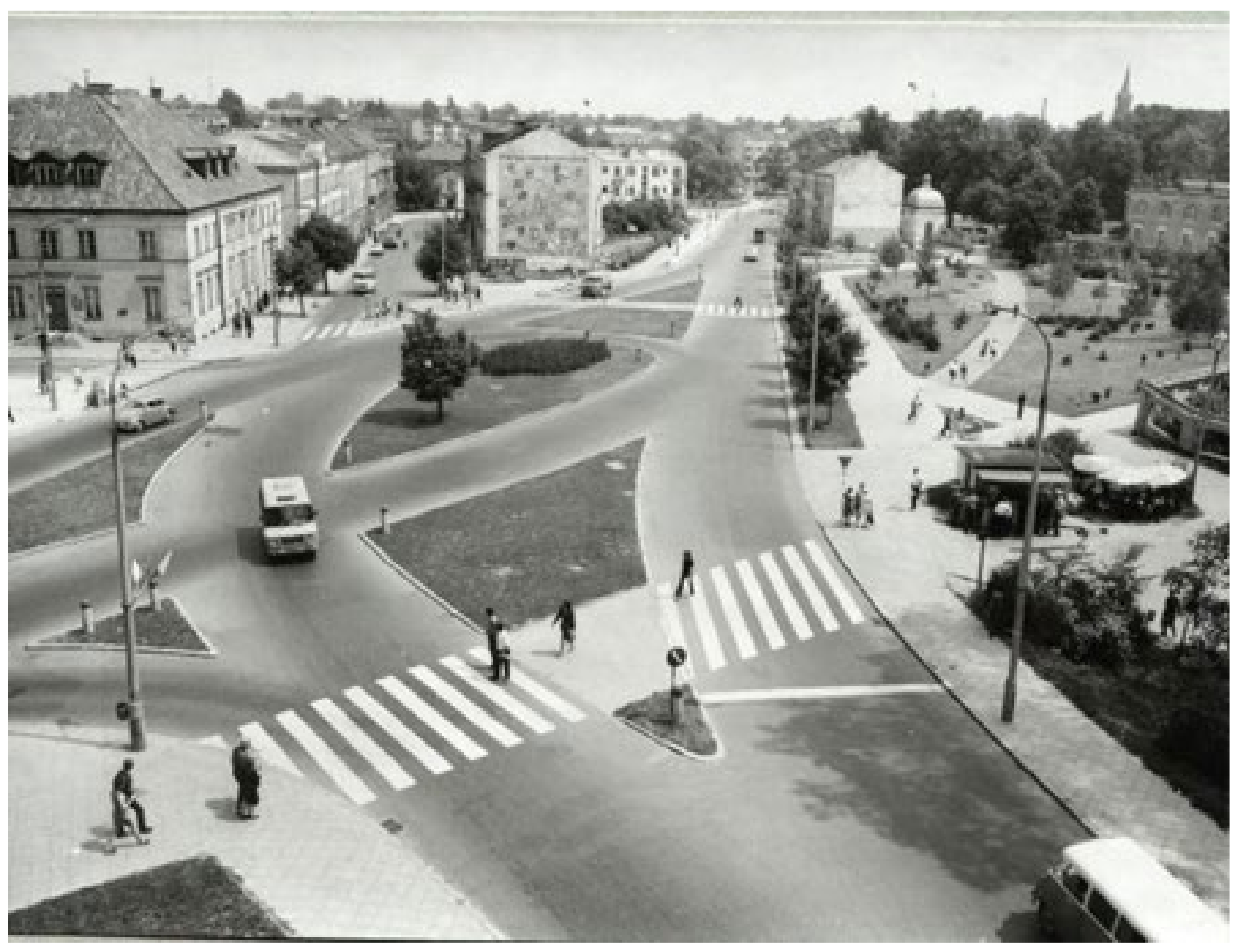
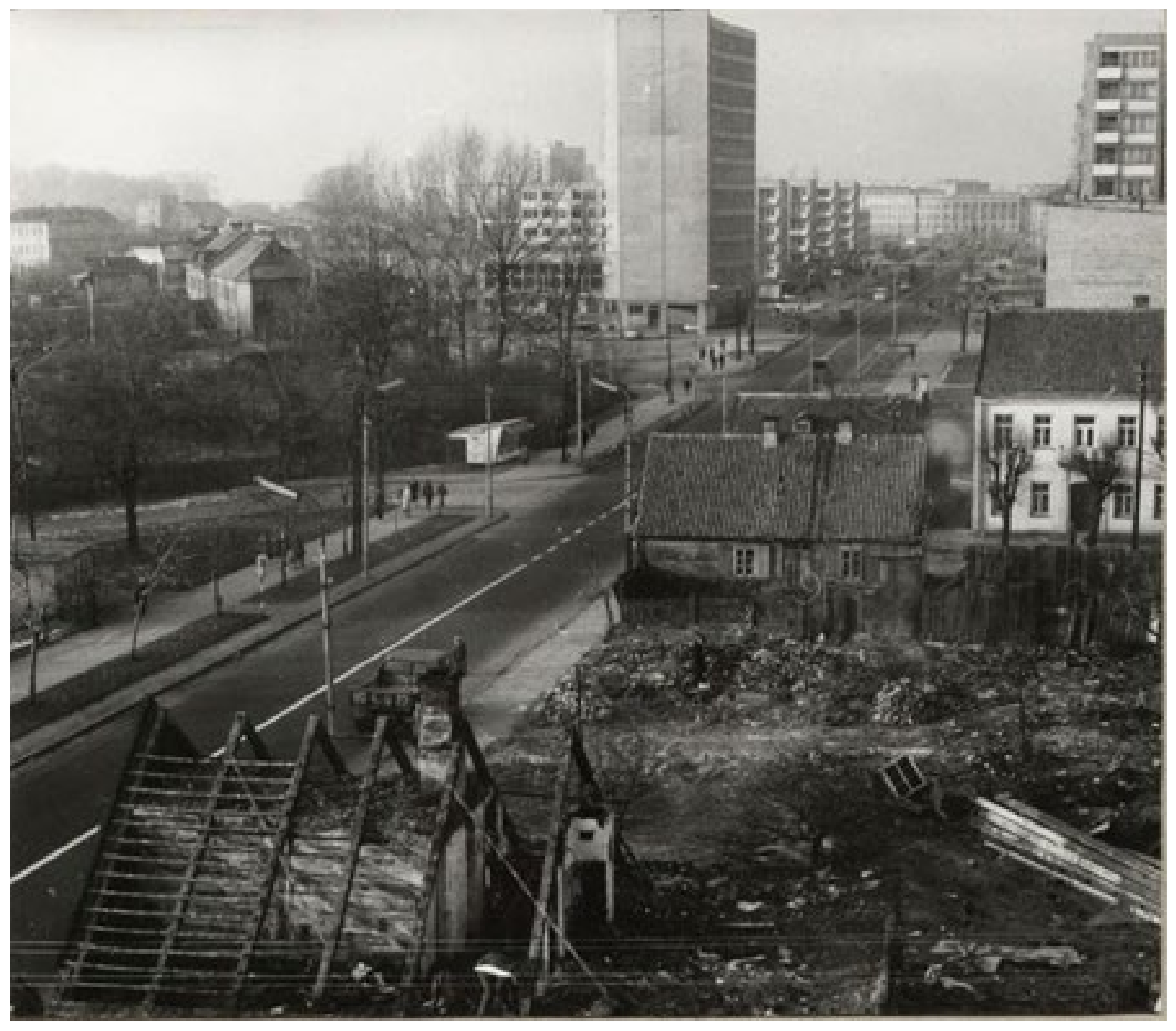
1.2. Study Scene: Białystok

Białystok is the capital of the Podlasie region in eastern Poland. Its population before World War II was 107,000 [21]; nowadays, without dynamically growing suburbs, up to 300,000 [22]. The region is among those with a low economic development and low population density in the EU, but habitants of Białystok declare quite a high level of happiness according to life quality surveys: the city is compact, the region is rich with attractive natural resources (national and landscape parks, forests, and lakes), and has a fast transport link to the Warsaw city center (ca. 2 h). The area is the node of transportation to Belarus and Baltic countries.
Białystok was established in the center of vast land estates. The city was formally founded in the 18th century to serve as a magnate residence [23]. The town center from that period and the monumental baroque palace complex are the strict center of the contemporary city. In the nineteenth century, the city experienced a dynamic development thanks to the construction of a railway junction at the intersection of lines to St. Petersburg and Konigsberg, as well as due to the development of the textile industry. Until the last quarter of the 19th century, the town’s buildings were almost exclusively timber constructions. Until World War II, the community of the city’s inhabitants was multi-ethnic, including having one of the highest shares of the Jewish population in Poland: 42.6% [24]. During the Soviet occupation, the Polish part of the population suffered severely. During the subsequent German occupation, it was primarily the Jewish population that was ruthlessly exterminated, and its property was plundered and destroyed.
Białystok was destroyed in 44% of the overall buildings, in the residential area in 51% and in the industrial development in 78.6% [25]. Białystok suffered in the course of repressions against the Jewish population (mass displacements, upraising in the Ghetto), as a result of the destruction caused by the retreating Nazi German troops, and by the advancing Red Army. The population loss was over 50%; in 1946, there were only 46,000 inhabitants present [26,27]. However, the key landmarks that built the identity of the city’s landscape in the collective consciousness, such as the four major Christian temples and the theater building located in prominent places in the city center, survived the war.
The reconstruction and reshaping of the destroyed city took place in the new political and economic realities of socialist economy, central planning and indoctrination with the socialist ideology common to all countries of the Soviet bloc. It was consistent with the guidelines from the Soviet Union as: “socialist globalization in two successive phases of socialist realism and socialist modernism” [28]. The landscape of the central part of the city has changed as a result of the introduction of buildings with completely different features than the previous ones, especially in terms of dimensions, and corrections of the layout of the urban plan. W. Kil wrote [3]: “…planners had—or perhaps were allowed—to dream up an almost entire cityscape using ‘socialist realism’. They certainly pulled out all the stops in their process of restorative reconstruction. (…) Partly recreated, partly reimagined buildings of different ages conjure up the atmosphere of an old seat of the Polish aristocracy on the narrow triangular marketplace.” The criteria used in making design decisions during the reconstruction time (depending on the period) were a mixture of the use of classicizing forms and functional criteria promoted by the Modern Movement, against which totalitarian communists generally fought.
The newly implemented urban layouts obtained a much larger scale of spaces (Figure 1) and development, increasing the height of the buildings. In terms of functional and spatial ideas, they were implemented as modernist housing estates. The growth of the population forced the centralized housing construction system to look for compromised solutions: faster construction of individual buildings, not complexes. The result of these efforts was the mixing of post-war and pre-war structures (Figure 2). The creation of new streets was supposed to improve transport according to new expectations, out of the historic center and also in the perspective of the expected development of peripheries.
Such a turbulent history of the city provokes questions about the range of continuity, to what extent the city structure retains its source code. Categories such as the identity [29,30] or genius loci [31] apply here. “The identity of the city is transformed, the genius loci is timeless” [31]. “Contemporary globalization processes have a greater impact on the city’s identity, the less politicians and city authorities are aware of its genius loci.” [27]. There is also the question of what constitutes the genius loci of the city, understood as a sense of the specific place. Andrzej Gawlikowski [7] quotes H. Syrkusowa, who in turn agreed with Oskar Sosnowski that the network of streets and squares forming the urban layout expresses the genius of each city. K. Wejchert, on the other hand, attached great importance to the elements crystallizing city plans as the main, characteristic, and long-term layered elements of the central part of their structures, necessarily with unique formal features. Either way, in the context of the elements representing the city’s identity in space, the layout of streets and squares, distinctive objects, as well as other buildings grouped into structural units characteristic of each city, are always mentioned.
In the case of Białystok, the following factors contributed to the transformation of the city in the second half of the 20th century: structural transformations, resulting from the introduction of new elements of the city plan in certain parts of downtown area—the spatial layout and communication arteries; architectural transformations, having two dimensions—the long-term replacement of wooden buildings with brick ones and the replacement of small-scale (usually wooden) buildings with larger-scale multifamily buildings. The changes in the structural dimension generally finished in the previous decade with the use of the European Union funds led to the transformation of the city plan from an irregular concentric layout into a concentric-perimeter one. Architectural transformations are still ongoing, in recent years especially, due to the excellent situation on the residential real estate market. This article analyzes the impact mostly of the first of these two types of transformations on the city landscape. Białystok is a good case for such an analysis, because of the deep nature of the transformation of the urban structure and, simultaneously, of the keeping of almost all the main landmarks in their original forms and locations.
Andrzej Gawlikowski clearly indicates that “the networks of streets are the least susceptible apart from ownership divisions and building substances to transformations” [7]. Thus, the creation of intersecting or overlapping grids is a huge, unusual interference in the structure of the city, in this case resulting from a historical cataclysm. It also had significant consequences, which should lead to the analysis of their impact on the city space.

1.3. Study Objectives

The research aims to determine the extent to which the city landscape changed as a result of the post-war reconstruction and transformation, including the creation of a duplicated urban grid. Particularly, it is about the reliable measurement indicators of whether it was an impoverished or enriched urban layout and city identity according to K. Lynch and K. Wejchert’s sets of urban landscape contents: “Man orients himself (in space) according to objects” [9]. The objects that form the basis of this orientation are outstanding buildings (landmarks) and special junction places (nodes of urban grid). According to K. Lynch, both elements belong to the basic structural elements of the urban landscape [14]. Hence, they can be a good basis for analyzing the qualitative changes in the city’s landscape and the direction of its transformations because of such a special process as the demolition and subsequent transformation during the city reconstruction. We take these two types of urban landscape elements as measures of changes. They serve as elements of the structural analysis. We omit an aspect of the mapping of urban structure by users, which was the further thread of the theory of K. Lynch.
The main aim of the research is to conduct a diagnosis of a city grid and to draw conclusions to the consequences of transformations during post-war reconstruction in relation to the quality of the city’s landscape. Specifically, two research objectives are identified:

1.3.1. Objective 1

(1) Based on the preliminary studies, we conclude that the scope and quality of the exposition of the main landmarks affects the condition of the urban landscape. The aim is to define the extent and direction of quantitative and qualitative changes in the exposition of each of the selected landmarks. Quantitative ones are understood as changes in the number of directions of exposition, when qualitative ones are understood as changes of rank of the directions of exposition.

1.3.2. Objective 2

(2) The identification of the direction of changes in the number and rank of connections and the distribution of nodal points and, additionally, making a comparison and balance of nodal points existing in the examined area before demolition and existing in the new structure. The objective results from the assumption that the number of nodal points and the rank of mutual connections prove the level of complexity of the urban structure and, indirectly, also the richness of the city landscape.
The ultimate goal is to formulate a quantified characteristic of the direction of changes in the landscape of the city subjected to the introduction of the attributes of modernity according to the criteria of the Modern Movement (first of all, broadly understood functionality) mentioned above, as a main idea of most post-war planners.

2. Materials and Methods

On the one hand, the inspiration for the proposed method of measurement was the theory of Kevin Lynch with his enumeration of the key elements of the urban landscape [15]. On the other, the idea of using an indicator such as an important element as the direction of the exposition, including the axis, in its various aspects, thoroughly used in the research of B. Hillier [32]. The research was based on the assumptions that the number and rank of visual connections (expositions) of significant identifiers of urban space as well as the number and, above all, the rank of nodal connections in the urban grid, which are squares and more important junctions, are one of the groups of indicators that reflect the level of urban landscape quality. Surveys of the opinions of space users were omitted, in order to look for measurable indicators, free from subjective opinions.
In order to investigate the consequences of changes in the urban landscape as a result of the post-war transformations in the structure of the urban grid, in the context of both assumed objectives, two categories of key elements were analyzed: one, selected landmarks, and two, selected nodes of urban grid, those last understood simply as city squares and other intersections of streets. The landmarks were selected from between those of the most significance which were preserved, even by reconstruction, except for the Branicki Palace, having, in fact, only one direction of exposition. The method was: one, to make a comparison and, as a result, balance of the number and rank of exposition of architectural landmarks directly and indirectly closing the axes (closed vista) [16] in the conditions of the pre-war and post-war urban grid structures; two, the comparison and balance of the number and rank of connections of nodes of the urban structure with surrounding elements of the city structure. A summary of changes in the number and distribution of both types of elements before the war and after reconstruction and transformation were presented. We measured the number of points before the war and after the post-war reconstruction and investigated whether it increased or decreased, i.e., we conducted a comparison and balance of them. Additionally, the structures of street grids from these two periods were graphically compared, as well as the changes in the distribution and concentration of both examined groups of elements in the analyzed area. Thanks to this, it was possible to compare both the number and the level of quality of connections, respectively: main and subordinate ones, and, according to landmarks, also the directions of direct and indirect axes of expositions.
The research material consisted of city maps from 1937 to 2021. They were supplemented by archival and contemporary photographs as well as field surveys.

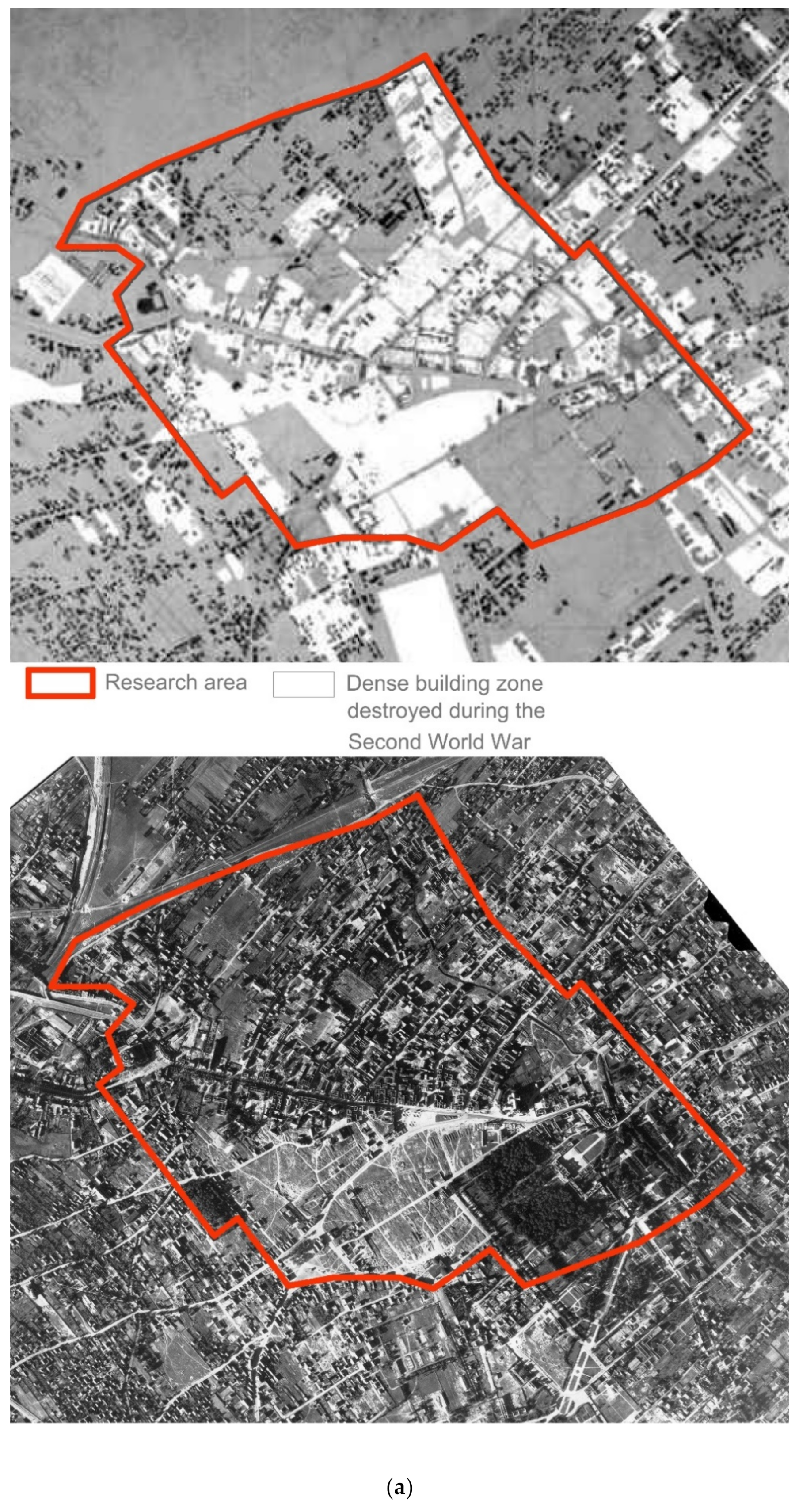
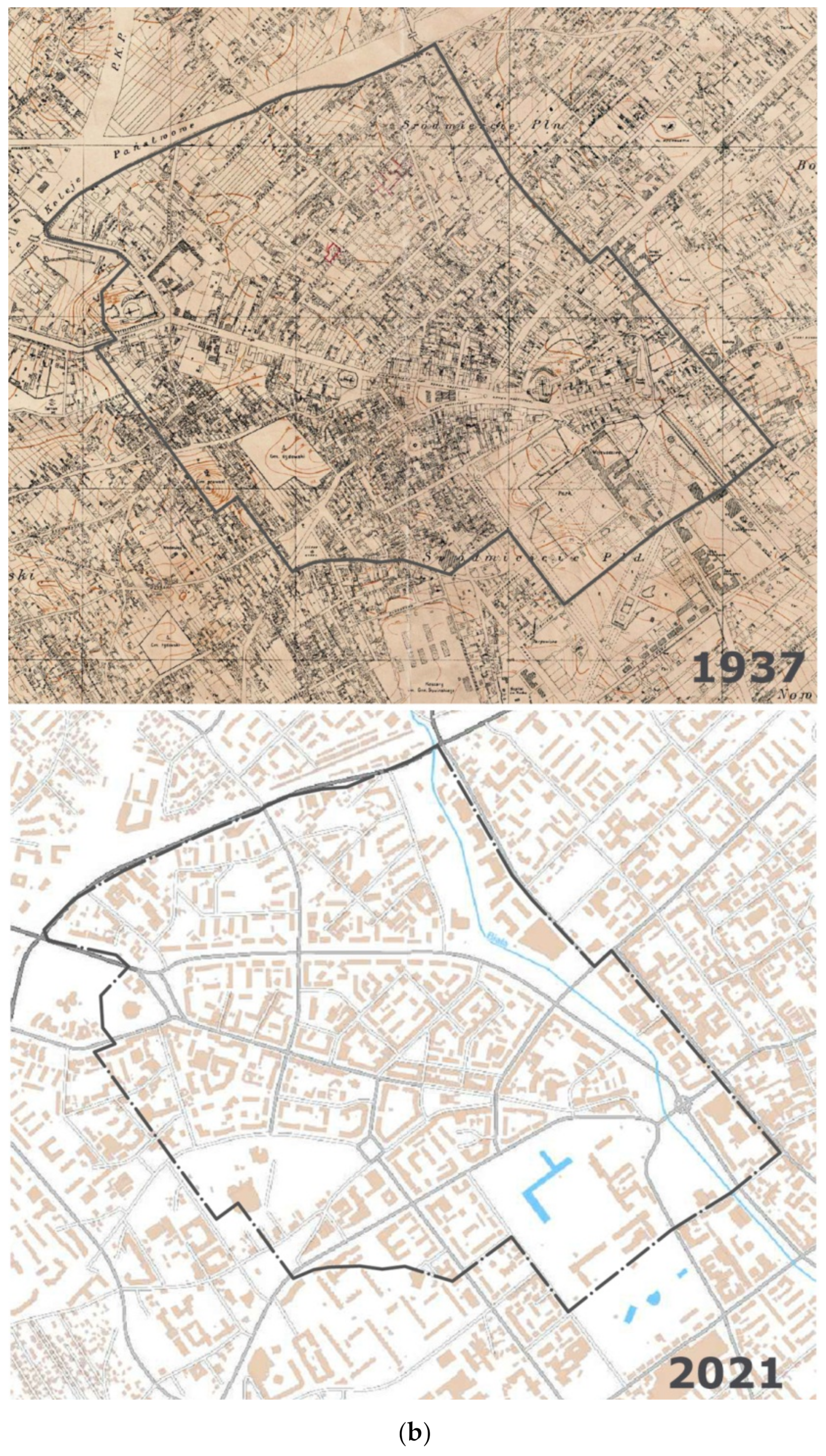
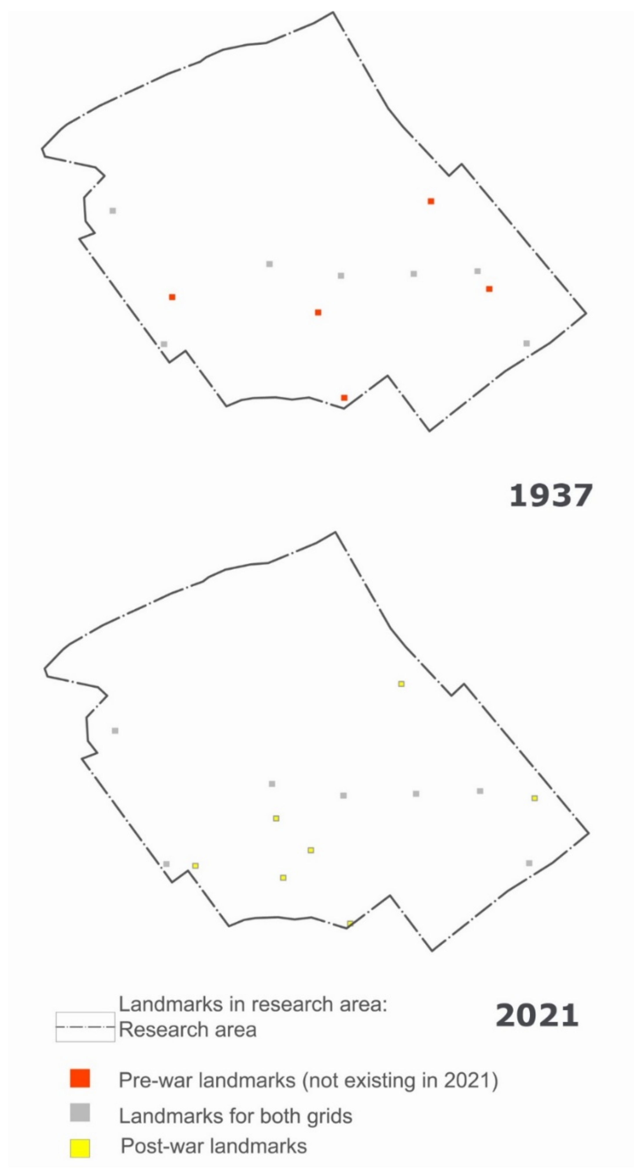
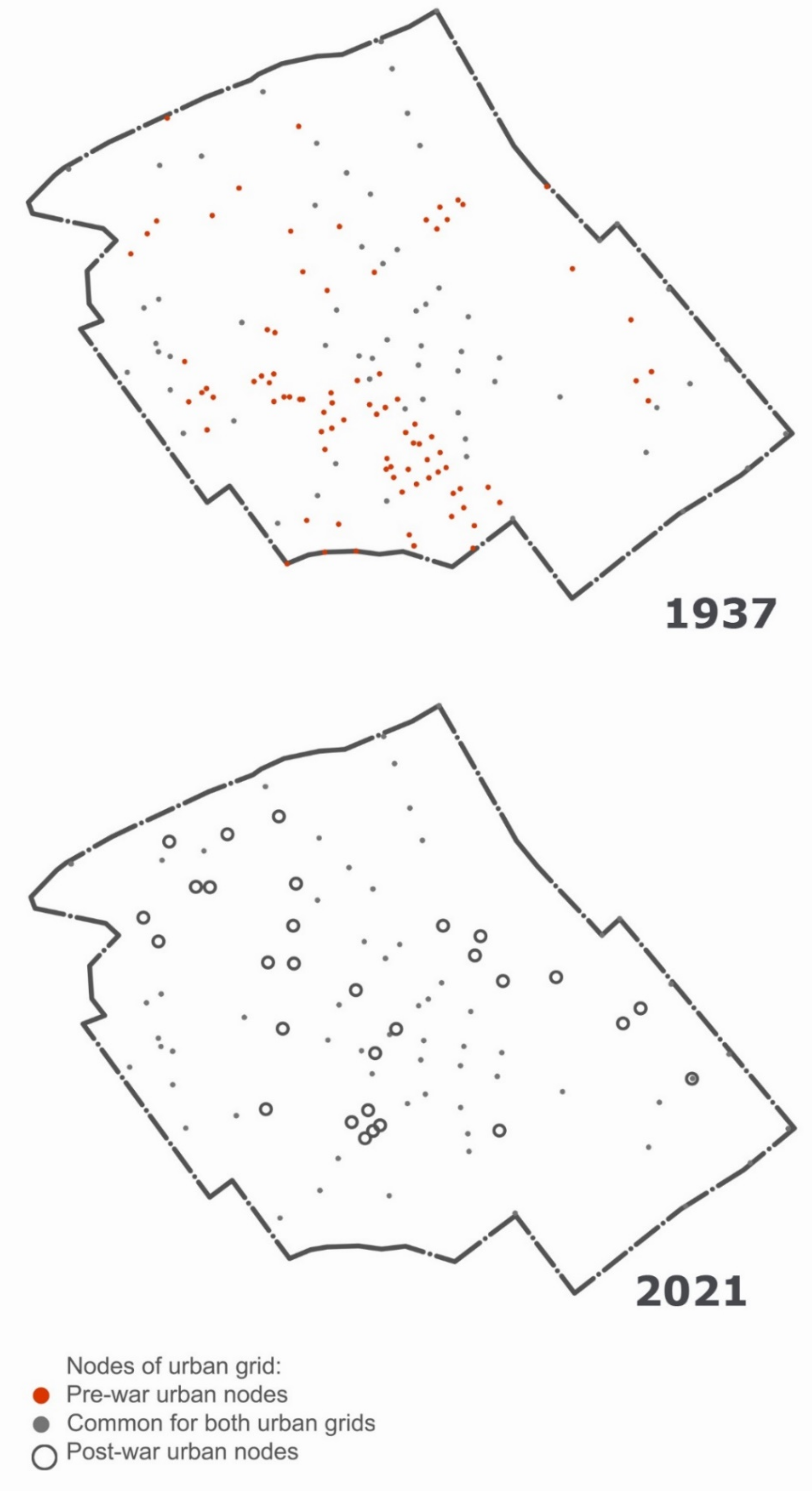
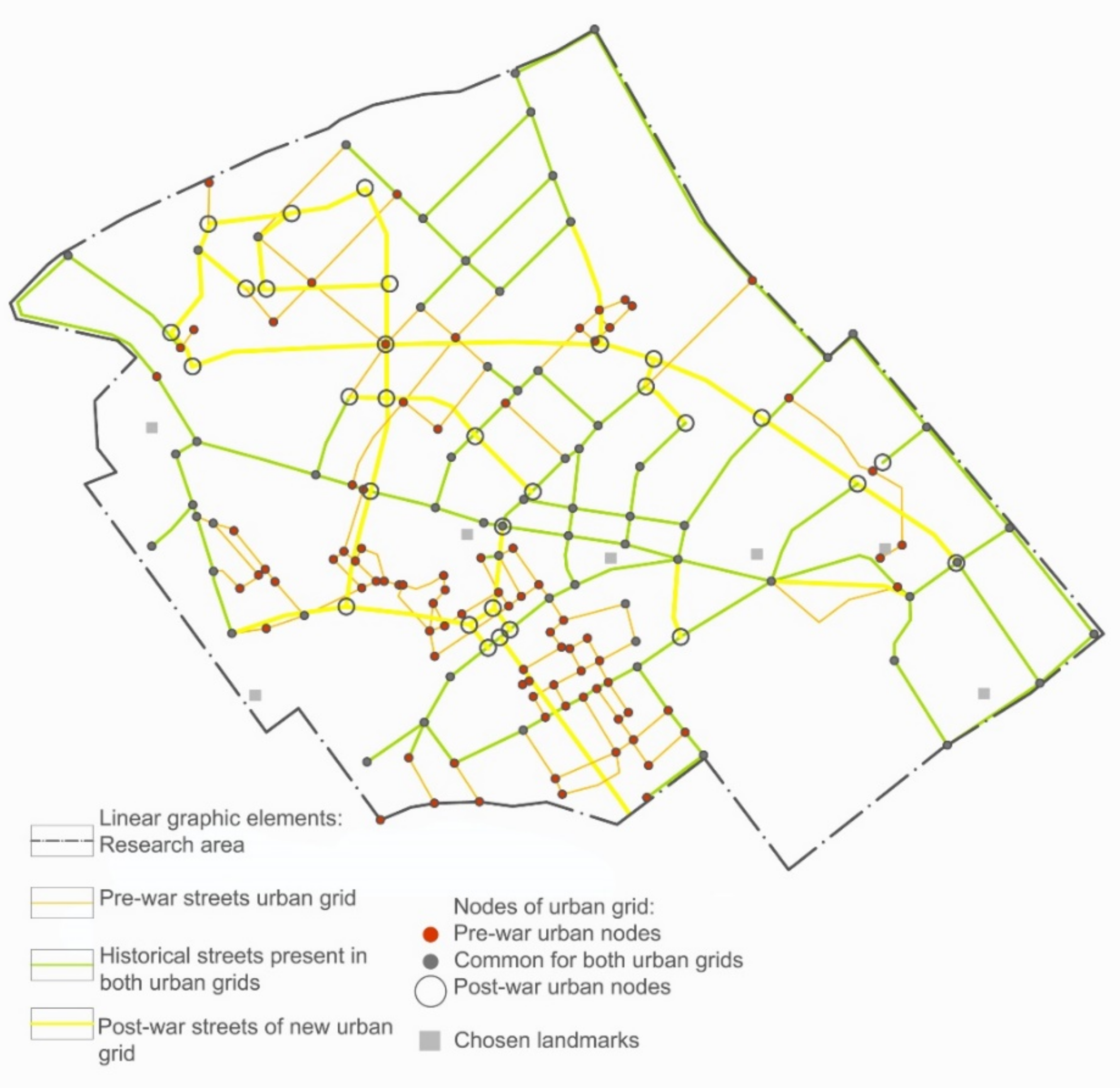
2.1. Selection of the Area

Suitable for the research was an area with an adequate density of urban fabric, i.e., saturated with different aspects of city landscape and, simultaneously, of a large level of post-war transformations. The areas of the city center selected for the research (Figure 3a,b), which, before the war, were its main downtown part and the most destroyed during the war, were Jurowiecka, Warszawska, Elektryczna, Akademicka, Sucha, Kijowska, Dąbrowskiego, Poleska streets. Before the destruction, it was the areas with the highest density of urban tissue, outside of which the density was significantly lower, often with significant discontinuities of the tissue, which disqualified those areas as the subject of research. It was almost the whole area of the contemporary downtown, except a part without war demolition on the western side. Therefore, the selected area was the main part of the city with a concentration of all urban attributes and the most important elements of the city’s landscape. The area was also the place where the greatest war damages took place, estimated at up to 80% of the substance [33]. Therefore, it was also the area of the largest and most intense post-war structural transformations, i.e., the most predestined for research.

2.2. Selection of Objects for Examination

Seven objects were selected for the study of changes in the conditions of exposition of landmarks, i.e., almost all public objects of a generally accessible and monumental form, exposed location, and, mostly, dominant or at least accentuated in height (“some landmarks are (…), typically seen from many angles and distances, over the tops of smaller elements, and used as radial references” [15]), which functioned both before and after the war in the tissue of the designated city area (Figure 4). These were three catholic churches and an orthodox one, that were not destroyed, located in the city center. Among these three there was the city theater that also survived the war and two objects destroyed during the war, having been reconstructed, and, thus, retained their location, scale, and basic form, and so, they could be classified as unchanged and the most important elements in the landscape of the area. The baroque Branicki Palace, rebuilt after the war, was omitted as an object without the features of a high-altitude accent, and also surrounded by an extensive park and garden area, which limited the possibility of direct exposition.
The nodal points, i.e., squares and intersections, were classified to the second group of the examined objects (Figure 5). In the further research procedure, nine of them were selected, including five points related to the discussed landmarks, while the remaining ones were selected in a regular urban grid as a result of identifying interference in the space that took place in the post-war period (Figure 6).

2.3. Procedure and Measures
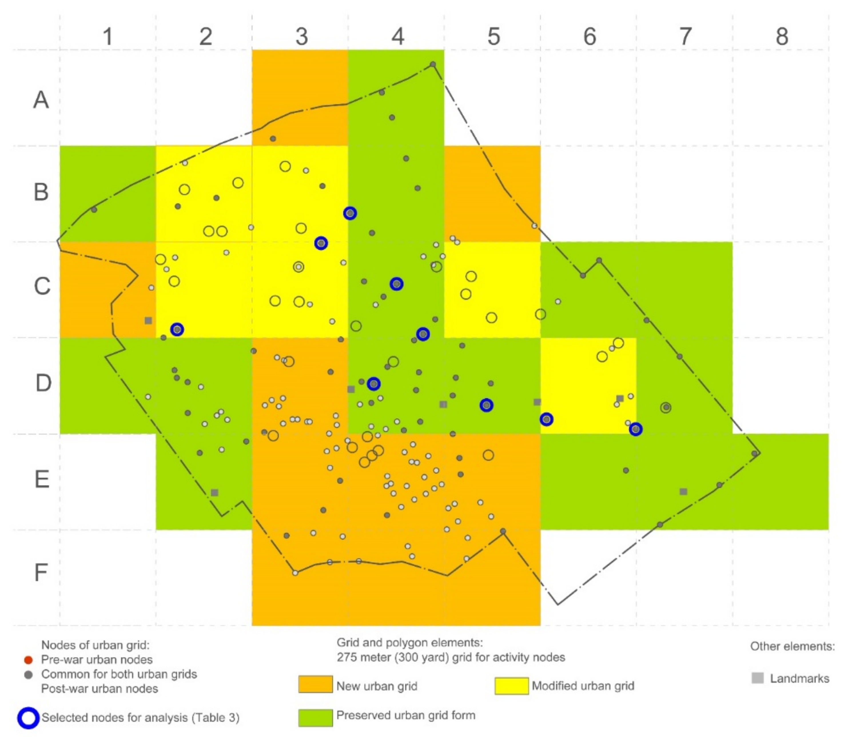
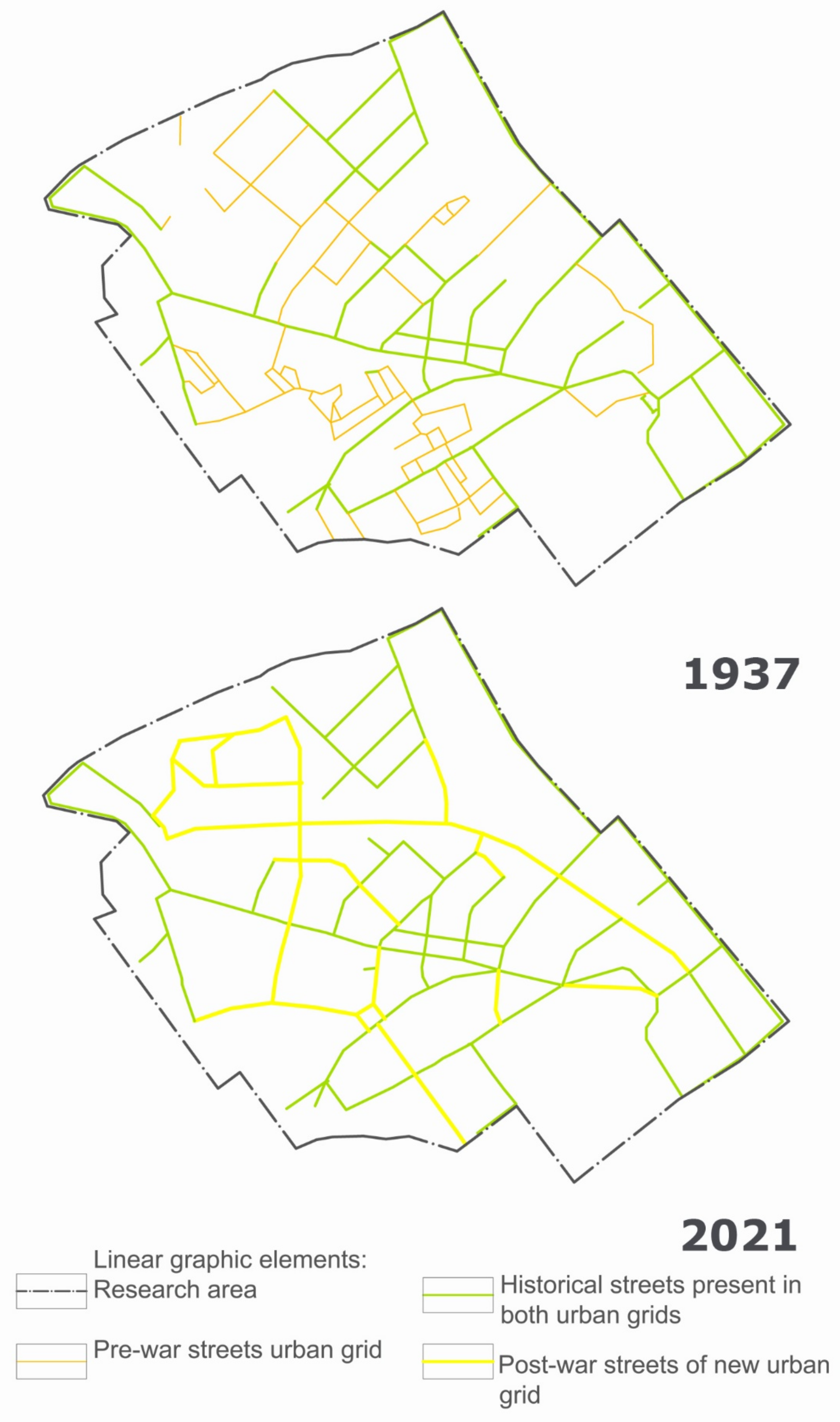
Regarding the selected landmarks, the directions of their expositions before the war and today were identified. These expositions were classified as: direct primary, direct secondary, and indirect primary and secondary ones. Additionally, the directions of the exposition from the pre-war period, which ceased to function as a result of changes in the height of buildings without changes in the structure of the street grid, were included. The exposition directions identified for both periods in the form of axis segments were indicated on the map. After removing the background in the form of a map, pairs of graphs were obtained for each of the seven analyzed landmarks (landmarks listed in Table 1, an example of the graphic representation in Figure 7). Then, the results of the analysis of all the graphs were placed in the table (Table 1). The procedure was proposed by the authors, based on K. Lynch’s typology of general elements of an urban landscape. Another inspiration was the approach of B. Hillier’s for axes as an indicator of spatial and visual connections with the use of polygon analysis well known in geography.
Regarding urban nodes, the estimation of the number and rank of connections was determined in relation to the state in 1937 and today (Figure 7). The results of analysis are presented in Table 2.
For the purposes of further research, the research area was divided with a grid with dimensions of 300 × 300 yards (275 m; [34]), creating sectors for further analysis (Figure 8). Such a division of the area helped to make measurable comparisons of an arrangement of specific elements (points)—in our case, urban nodes. The length of a side of 300 yards gave an optimal, for comparisons, number of sectors over the area and, on the other side, according to the density of urban structure. The area of 300 × 300 yards consisted of even a few neighborhood communities and a few hierarchical nodal points [34]. There also is a large possibility of presence of nodes of different rank in each of the sectors. The city has a radial-perimeter layout, and the baroque layout is a triaxial one, in which the main street (Lipowa Street) has a direction similar to the east–west axis; hence, the selection of the N–S axis was methodically neutral and more universal for the examination of the point index, ignoring the linear layout of the streets. The highest number of nodal points (≥10) was found in the sectors (Figure 8): C4 (12), D2 (10), D3 (18), D4 (14), E4 (24). It was the area of uncontrolled expansion of the city in the nineteenth century and the emergence of poor workers’ buildings with short streets and alleys in the area. In order to indicate areas of interference with the urban tissue in the post-war period, the distribution of nodal points was referenced to the above-mentioned polygon grid. The characteristics of the process of changes in the distribution and concentration of nodal points in the studied area was prepared by analyzing changes in their number in individual sectors (Table 3 and Figure 8). Three indicators were used to help to identify the structure dominant in a given specific square: a new urban grid in the case of a greater number of non-existent points than the sum of was preserved and new points (X1 > X2 + X3), a preserved urban grid when the number of preserved points was equal to or greater than both the number of non-existent and new ones (X1 ≤ X2 ≥ X3); a modified urban grid when the number of new points was equal to or exceeded the number of saved ones (X2 ≤ X3). In the next stage, nine previously selected nodal points common to both urban grids were examined: the directions and the rank of outgoing spaces connecting them with other parts of the structure were identified and marked according to the state in 1937 and today. The results are summarized in Table 2. In all cases, the state before war damage and the present day were marked separately.

3. Results

The results presented in the table showed seven analyzed distinctive objects within the borders of the research area, which played the role of identification elements in space before the war and retaining this role after reconstruction and transformation. As a result of the reconstruction, two objects one1 and four) gained new directions of direct visual exposition along the streets of the main rank (appropriately two and one directions of exposition). Two other objects (five and seven) obtained new directions of direct exposition in connection with the sub-rank street sequences (three in total). Although two of them were routes (directions) that existed earlier, their rank decreased. For all objects, the overall balancing of this group of exposition directions as a result of reconstruction was negative, respectively, −1 and −2. The balance was even lower with regard to both categories of exposition directions realized indirectly—through the main and secondary streets—; in these cases, only one object (1) gained one main direction of exposition. Thus, the balance for the seven objects for the main directions of exposition was −3 out of 17 (−18%), and for the subordinate expositions it was −8 out of 21 (−38%). For direct expositions, the balance was −1 out of 19 (−5%) and for the intermediate −10 out of 19 (−53%).
It was found that, out of a total of 176 nodal points, 30 of them were points of the new post-war urban grid. In the analyzed pool, 146 points were historical nodal points, 63 of them were part of the contemporary urban grid, and 83 of them belonged to the nonexistent pre-war spatial structures (57% of the total points of the historical grid). The contemporary spatial structure consisted of 93 nodal points, the points of the new post-war urban grid constituted 32%, and the points of the pre-war grid constituted 68% (Table 3).
Large modifications were found in sectors A3, B2, B5, C1, D3, E3, E4, E5, F3, F4, and F5. Some of the sectors (D3, E3, E4, E5, F3, F4, and F5) (Table 3 and Figure 8) covered the area of the former Jewish districts of the pre-war southern downtown, razed to the ground in the period 1941–1944. They were rebuilt with a completely new urban network. The group of the preserved urban grid included the sectors A4, B1, B4, C6, C7, D1, D2, D4, D5, D7, E2, E6, E7, and E8. In the case of sectors D4 and D5, they coincided with the area of the city center, where it was decided to keep the 18th century grid with the modernization of street parameters and the construction of housing estates (socialist realism). The remaining areas, despite the profound spatial transformations related to the implementation of the new buildings, retained their historical layouts. Introduced modifications were related to the parameters of the streets and the implementation of the new housing development as modernist housing estates. Sectors B2, B3, C3, and C5 were those in which the pre-war street grid was less intense. The changes that took place in the space included the construction of a new avenue to relieve the main street of the city and the construction of new modernist housing estates in a part of the former Jewish ghetto.
It is worth paying attention to the reduction in the total number of nodal points in the studied area. The reconstruction of the communication system caused dramatic changes in the shaping of the space and the disintegration of the structure of the studied area. In the area of the newly built urban grid (yellow, Figure 8), spatial conflicts arose because of the reconstruction in the places where buildings met two grids. These were fragments of streets with old buildings, today sometimes only lonely ones, turned 45 degrees in relation to the surrounding post-war buildings.
Then, nine nodal points were selected (Figure 8) to examine connecting directions, five on the historical baroque axis (one of the three triaxial systems of the Branicki Palace) in connection with the previously discussed landmarks. Four points were selected in the urban tissue of sectors B3 and C4. The criterion was the location of these nodes on the border with the artery pierced after the war bypassing the city center (J. Pilsudski Ave.). Points from areas B4 to C4 were located in a regular historical grid without landmarks, transformed or modernized in the post-war period.
Based on the results of Table 2, it was found that, out of the nine examined points, the first five were located on the historical baroque axis around which the city developed in the 18th and early 19th centuries, harboring churches and other public buildings. After World War II, several new streets and punctures were introduced as corrections to the traffic system. In the case of the first five nodal points (on the historical baroque axis), there were two reductions in main connections. On the other hand, the number of subordinate links increased to three. Only in the case of the first point (St. Roch’s Church), the direction was reduced without changing the layout. In the remaining cases, the shift of rankings in the number of four resulted from the transformation of the spatial system of nodal points. In each case of the implementation of a new street and the same: new direction, in two cases, the connections were broken. In the case of points located in the area of the preserved historical grid, an increase in the number of main directions of connections was found, resulting from the increased rank of outlet streets modernized during reconstruction. The situation was different in the case of points located at the artery built in the post-war years: the main and secondary connections (−2, −2) were reduced and the rank was shifted due to changes in the communication system.
As a result, the following changes took place in the studied group of nodal points:
  • Changing the rank of streets forming a node and reorienting the spatial structure;
  • Introduction of new streets (Plac Jana Pawła II Street, section of Sienkiewicza Street);
  • Liquidation of some streets (Szlachecka Street, earlier the end of Nowy Świat Street);
  • The loss of the importance of some streets due to spatial changes (Nowy Świat Street, the pre-war main street of the northern Jewish district).
When comparing the street grids (Figure 9), there was a clear reduction in the number of grid elements and, thus, a reduction in its density. Thus, the average area of the individual quarters defined by the new grid also increased. Taking into account the importance of the streets, the reasons for this reduction could be seen: changes were introduced to build two bypasses to relieve the main pre-war Lipowa Street.

4. Discussion

The main aim of the research was to conduct a diagnosis of a specific, dual city grid and to draw conclusions as to the consequences of transformations during post-war reconstruction in relation to the quality of the city’s landscape. Two work objectives were identified:
Objective 1—determining the direction of quantitative and qualitative changes (number and rank) in the exposition of each of the selected landmarks.
Objective 2—determining the direction of changes in the number and rank of connections and the distribution of nodal points.
Results indicated that (Table 1) the number and rank of the exposition axes of individual landmarks clearly decreased, and to a much greater extent for the secondary and intermediate ones (38% and 53%). This was understandable as the grid was put in order, many of the spontaneously created and secondary streets and alleys were removed. The change in dimensions, including the height of buildings, was of marginal importance for the changes in the exposition level. In the analyzed examples, it concerned only case two, which, due to the increase in the height of buildings, lost two directions of indirect exposition, including one of a high rank. In practical terms: the number of lower rank expositions decreased to a greater extent. This was related to the reduction in subordinate spaces and the creation of arteries, mostly with the features of technical spaces. In the course of the reconstruction, some ordering of the network of connections was conducted. Many small and spontaneously created streets were eliminated by these new arteries. The priority was the technical requirements of transport and infrastructure, not the composition or creation of social spaces, which in the old structure were characteristic for small old streets and alleys.
It can, therefore, be concluded that, as a result of the reconstruction and the implementation of its assumptions, which continued for decades, the city gained a more efficient network and adapted to the requirements of the modern and larger city transport system. On the other hand, the city landscape was impoverished because of the reduction in the exposition of the most monumental and characteristic objects and, at the same time, the elements of the space became determined by technical criteria, to the disadvantage of the social and community dimension of urban space. Many intimate spaces in which neighboring communities were rooted before the war were liquidated. The dimensions of these transformations were certainly influenced by the increasing requirements for technical parameters, especially the width of streets, width of sidewalks, a distance of 6 m from the building wall to the edge of the road, as well as the distance between the walls of buildings if there were windows to the residential rooms. In some post-war periods, these changing requirements derived from the ideals of the Modern Movement took on a very strict character [35]. All this resulted in limitations in the possibility of compacting the street grid, and as a result reduced its intensity. Consequently, it impoverished the urban landscape in a way. However, of course, this cannot be equated directly with a reduction in the level of quality and, especially, the functionality of the structure of the urban tissue. On the contrary, there was an improvement in the conditions for a good general standard of living in such a tissue, especially through the lighting of flats and the size of residential green areas. At the same time, it was associated with the deterioration of conditions for the creation of small, integrated neighborhood communities in the area of the city center.
This was confirmed by the analysis of the change in the quantitative structure of the directions of exposition: the number of subordinate directions (7 out of 10) decreased to a greater extent than the number of main ones. It was certainly related to the evolution of traffic arteries as technical spaces in the city structure, described by Gawlikowski [7]. They structured the city to the disadvantage of multi-functional streets as spaces with cultural potential. This was also confirmed by the analysis of changes in the structure of nodal points in the context of their embedding in the changing street grid. Results (Table 3 and Figure 8) indicated a decrease in the number of historical nodal points at the level of 57%. Not only were nodal points subject to decline, but also the connections between them (streets). Spatial changes were particularly visible in Figure 6. They were concentrated in areas and not accidental interventions in the spatial structure of the city, in contrast to other destroyed cities that suffered as a result of the ‘Blitz’ [6]. They were the result of the extermination of the city’s inhabitants of the Jewish nationality and the city space they occupied. In July 1941, a Białystok ghetto was created, and districts previously inhabited by Jews were demolished (areas D3, E3, E4, E5, F3, F4, and F5) [24]. In 1943, the ghetto was also liquidated (areas A3, A4, B2, B3, B4, B5, C3, and C4). The destruction in this area was of various natures, the quarters close to the center and industrial plants were destroyed, and a small part survived (A4, B4, and C4). In 1944, during the retreat of the Germans from the city, the culturally valuable buildings were destroyed: public buildings and the buildings on the main streets. It related to the activity of Brandkommando and the methodical destruction of cultural heritage. Among the sacred buildings, only Christian churches survived. In response to such actions of the occupation forces in the reconstruction of cities in the 1950s in Poland, contrary to the conservation doctrine used in other countries, it was decided to rebuild objects of cultural value and to recreate the main historical urban layouts. Often, however, with the modernization of street parameters. In the 1960s, this practice was abandoned in favor of the modernist trend in urban layouts. This showed the specific conditions of the spatial changes described in the article. The decrease in the number of nodal points resulted from the liquidation of ethnic districts, which had the character of an irregular, substandard urban tissue typical for the 19th century workers’ slums. It was decided to recreate only the fragments of the 18th century composition of the city with the greatest spatial value (most of the selected landmarks were its elements). The city space in the substantial and physical dimension was preserved in a negligible percentage. The cultural continuity was broken, yet the rebuilt landmarks remained an integral part of the city’s identity [36]. The complexes implemented since the 1960s were characterized by the abandonment of historical spatial structures, including the rejection of the street as the main element of the public space (and, thus, junction points). After the war, the city’s development was planned on a much larger scale, and thinking about the city center also had to go beyond the traditional area. In planning, transport needed to be understood in a new scope and the possibility of satisfying it began to dominate, mainly, the desire to bypass the center, as well as ownership changes, so old important objects ceased to be destinations, and the structure of the city plan became changeable. There was a radical change in the way space was composed in the city’s landscape. In the context of the categorization of landscape changes, we can speak of changes in landscape macro compositions [12].
In modern spatial assessment categories, when we paid more attention to the level of quality of connections in the city structure and to the quality of the urban landscape, it could be stated that from this point of view the city landscape became depleted.
The research presented in the above study had its limitations, of course. According to the K. Lynch theory, we did not touch the human perception of the described changes of the city landscape by users; we just summed (balanced) changes in the number and rank of examined ingredients of the urban structure. We used only two from five elements of the city image (landmarks and nodes). Others (paths, districts, and edges) were not useful for our approach which was focused on changes of the structural network of the city. Similarly, we used only the idea of structural importance of axes, without their role as the indicators of spatial integrity, explored by B. Hillier.

5. Conclusions

An analysis of the changes in the city’s landscape as a result of the transformation of its plan during the post-war reconstruction was presented. The research field was the area of the city center—its main pre-war part, which was most damaged during the war. The city plan after the war was transformed towards the introduction of elements improving its functionality, measured by criteria characteristic for the Modern Movement, wide transport arteries and extensive intersections to ensure the safety and efficiency of the increasing traffic of motor vehicles as the core of public space. Large, multi-apartment, free-standing buildings were introduced as housing, to provide access to the sun, greenery and standardized housing conditions for the largest possible number of residents. These elements introduced a new quality to the structure of the city; above all, a new scale, which in the case of the research area adopted within the permanent boundaries resulted in a quantitative impoverishment of the structure of the city tissue. The new scale of the structure resulted in the liquidation of many subordinate spaces (streets, squares, and courtyards), which were used by small neighborhood communities (Figure 8). The new structures were open spaces with unlimited access and much larger, undefined circles of users. However, the research also showed some deficiencies among the elements of the main rank (directions of expositions, urban nodes connections). Most of such cases concerned the reduction in the rank of the main existing elements, sometimes the loss of functionality (loss of the patency of the old streets, obscuring the exposition directions by new buildings). As a result, among other things, the exposition of the city’s main landmarks, which were also them in the pre-war period, became impoverished. As a result of the post-war reconstruction, the spatial structure of the studied part of the city gained functionality in new conditions: a greater efficiency of vehicle movement in the city scale was ensured, and, therefore, the basis for the city’s development on a much larger scale than it was before the war (107,000 inhabitants vs. 300,000+ suburban area). This made it easier to be the center of the functional area as well as the regional capital today. However, the identified changes justified the conclusion that the structure and urban landscape in the study area became depleted in terms of the number of elements, but also to some extent decreased the rank of many of them, because the rebuilt structure was dominated by a smaller number of elements, mainly creating the technical, not social spaces. The new elements of the structure were planned under the influence of the functional criteria and, possibly, the availability of land, rather than in places free from preserved buildings. The criterion of exposition of landmarks was omitted; hence, the new arteries were characterized by the randomness of shaping important aspects of the urban landscape: visual openings and closings. This was also shown by the comparison of Rotterdam’s plans: pre-war and the present one [5]. The number and rank of the expositions of the main dominants, which were mainly buildings of symbolic meaning, were reduced. All this led to the conclusion that the urban landscape after the reconstruction, although it offered better conditions to its inhabitants from the functional point of view, was impoverished qualitatively, and the quantitative impoverishment refers to the limitation of spaces of a human scale, including those for small communities. Thus, the social dimension of the city center space was limited in favor of its technical dimension.
The adopted method of analysis was limited to the features of the city structure, in terms of conclusions resulting for the city landscape. Basically, it did not allow for a detailed characterization of the features of individual spaces. Post-war reconstruction was influenced by the ideas of the Modern Movement in urban planning. Therefore, the conducted analysis was also an assessment of the impact of the Modern Movement idea for selected indicators of the city’s landscape quality.
The presented study is a contribution to the original, in the authors’ opinion, approach to the quantitative and qualitative analysis of the effects the influence of the transformations of the spatial structure (city plan and, to some extent, buildings) had on the city landscape. The method used was inspired both by the classification of elements of the urban landscape structure by K. Lynch, and also by K. Wejchert and G. Cullen, as well as by the diagnostic role of the axes used by B. Hillier. Our analysis showed what elements, features of the urban landscape, and its social rank were lost, gaining greater functionality, mobility, but sometimes also a more total, humanitarian character of the city landscape and urban space. Such a conclusion was articulated during different discussions and publications between the end of the 1970s till the 1990s (architects: Henryk Toczydłowski, Andrzej Chwalibóg, and many others), but, as the result of our research, we delivered clear evidence of that.
The question for social research is whether the preservation of the characteristic, main symbolic landmarks of the city ensures the preservation of the Genius loci, or does the change of the social structure and the transformation of the spatial structure irretrievably destroy it.

Author Contributions

Conceptualization, B.C. and M.P.C.; methodology, B.C. and M.P.C.; software, M.P.C.; formal analysis, B.C. and M.P.C.; investigation, M.P.C.; resources, M.P.C.; data curation, M.P.C.; writing—original draft preparation, B.C. and M.P.C.; writing—review and editing, B.C.; visualization, M.P.C.; supervision, B.C.; project administration, B.C.; funding acquisition, B.C. All authors have read and agreed to the published version of the manuscript.

Funding

This research was funded under project no. WZ/WA-IA/2/2020 at the Białystok University of Technology, financed by a research subsidy from the Polish Ministry of Education and Science.

Data Availability Statement

Some publicly available datasets were analyzed in this study, as reported in the reference section. The new data created in this study are available on request from the corresponding author.

Acknowledgments

Authors would like to thank the City of Białystok Municipality for access to archival sources.

Conflicts of Interest

The authors declare no conflict of interest. The funders had no role in the design of the study; in the collection, analyses, or interpretation of data; in the writing of the manuscript, or in the decision to publish the results.

References

  1. Almusaed, A.; Almssad, A. City Phenomenon been urban structure and composition. In Sustainability in Urban Planning and Design; Almusaed, A., Almssad, A., Truong-Hong, L., Eds.; IntechOpen: London, UK, 2020; pp. 1–29. [Google Scholar]
  2. Szulc, K. Problem Ciągłości Rozwoju Miasta na Przykładzie Białegostoku; Man: Białystok, Poland, 1997; Volume 2. [Google Scholar]
  3. Kil, W. Reconstruction as a chapter of urban history. A comparison of Neubrandenburg and Białystok. In Laboratory of Modernism Post-War Architecture in Europe; Sonntag, I., Ed.; Saxon Academy of Arts: Dresden, Germany, 2014; Volume 40, p. 47. [Google Scholar]
  4. Rykwert, J. Pokusa Miejsca. Przeszłość i Przyszłość Miast (The Seduction of a Place. The History and Future of Cities); MCK: Cracow, Poland, 2013; Volume 21. [Google Scholar]
  5. Ostermann, I. Rotterdam’s dynamic approach to reconstruction. In Laboratory of Modernism Post-War Architecture in Europe; Sonntag, I., Ed.; Saxon Academy of Arts: Dresden, Germany, 2014; Volume 152, p. 159. [Google Scholar]
  6. Clapson, M.; Larkham, P.J. The Blitz, its Experiences, its Consequences. In The Blitz and Its Legacy. Wartime Destruction to Post-War Reconstruction; Clapson, M., Larkham, P.J., Eds.; Routlege: London, UK; New York, NY, USA, 2013; Volume 33, pp. 17–40. [Google Scholar]
  7. Gawlikowski, A. Ulica w Strukturze Miasta (A Street in Urban Structure); Wyd. PW: Warsaw, Poland, 1992; Volume 16, p. 78. [Google Scholar]
  8. Pallasmaa, J. Myśląca Dłoń. Egzystencjonalna i Ucieleśniona Mądrość w Architekturze (The Thinking Hand: Existential and Embodied Wisdom in Architecture); Fundacja Instytut Architektury: Cracow, Poland, 2015. [Google Scholar]
  9. Żmudzińska-Nowak, M. Miejsce: Tożsamość i Zmiana; Wyd. P. Śl.: Gliwice, Poland, 2010. [Google Scholar]
  10. Rybak-Niedziółka, K. Miasto Jako Krajobraz; Pan Kpzk: Warsaw, Poland, 2018; Volume 50. [Google Scholar]
  11. Böhm, A.; Zachariasz, A. Architektura Krajobrazu i Sztuka Ogrodowa (Landscape Architecture and Art of Gardening); PWN: Warsaw, Poland, 2005. [Google Scholar]
  12. Sas-Bojarska, A. Przewidywanie Zmian Krajobrazowych w Gospodarowaniu Przestrzenią z Wykorzystaniem Ocen Oddziaływania na Środowisko na Przykładzie Transportu Drogowego (Prediction of Landscape Changes in Land Use Management. Using Environmental Impact Assessment with the Example of Roads); Wyd. PG: Gdańsk, Poland, 2006; Volume 11, p. 55. [Google Scholar]
  13. Znaniecki, F. Socjologiczne Podstawy Ekologii Ludzkiej; UAM: Poznań, Poland, 1938; Volume 32. [Google Scholar]
  14. Iwańczak, B.; Lewicka, M. Affective map of Warsaw: Testing Alexander’s pattern language theory in an urban landscape. Landsc. Urban Plan. 2020, 204, 2. [Google Scholar] [CrossRef]
  15. Lynch, K. The Image of the City; MIT Press: Cambridge, MA, USA, 1960. [Google Scholar]
  16. Cullen, G. Obraz Miasta (The Concise Townscape); Teatr NN: Lublin, Poland, 2011; Volume 43. [Google Scholar]
  17. Wejchert, K. Elementy Kompozycji Urbanistycznej; Arkady: Warszawa, Poland, 1974. [Google Scholar]
  18. Dąbrowska-Budziło, K. Treść Krajobrazu Kulturowego w Jego Kształtowaniu i Ochronie; Wyd. PK: Kraków, Poland, 2002; Volume 316, pp. 103–104. [Google Scholar]
  19. Hall, E.T. Ukryty Wymiar (The Hidden Dimension); Muza: Warsaw, Poland, 1997; Volume 186. [Google Scholar]
  20. Batty, M. Cities and Complexity. Understanding Cities with Cellular Automata, Agent-Based Models and Fractals; MIT Press: Cambridge, MA, USA, 2007. [Google Scholar]
  21. Available online: https://sztetl.org.pl/en/towns/b/397-bialystok/100-demography/20362-demography (accessed on 18 August 2021).
  22. Urząd Miejski w Białymstoku, Raport o Stanie Miasta Białegostoku; UM: Białystok, Poland, 2019; Volume 11.
  23. Turecki, A. Plan du Chateau et de la Ville de Bialystok avec Ses Environs; Zeszyty Naukowe Politechniki Białostockiej, Nauki Techniczne–Architektura: Białystok, Poland, 1996; Volume 16. [Google Scholar]
  24. Bender, S. The Jews of Bialystok during World War II and the Holocaust; Brandeis University Press: Waltham, MA, USA, 2008; Volume 19. [Google Scholar]
  25. Chodorowski, M. Obraz miasta Białegostoku po II wojnie światowej jako punkt wyjściowy do analizy przekształceń przestrzennych w okresie powojennym na podstawie ‘Inwentaryzacji stanu zagospodarowania miasta Białegostoku-1948 r. (Image of the city of Bialystok after World War II as starting point for the analysis of spatial transformations in postwar period based on the ‘Inventory of the development of city Bialystok-1948). Archit. Artibus 2012, 11, 5–17. [Google Scholar]
  26. Barwijuk, A. Zmiany struktury społeczno-gospodarczej miasta Białegostoku w latach 1944–1964 (Changes in socio-economic structure of Bialystok town 1944–1964 Period). In Studia i Materiały do Dziejów Miasta Białegostoku; Antoniewicz, J., Joka, K., Eds.; Białostockie Towarzystwo Naukowe: Białystok, Poland, 1970; pp. 193–220. [Google Scholar]
  27. Dobroński, A.C. Białystok Historia Miasta; Zarząd Miasta Białegostoku: Białystok, Poland, 1998. [Google Scholar]
  28. Królikowski, J.T. Genius loci jako źródło tożsamości miasta (Genius loci as a source of identity of a city). In Projektowanie Krajobrazu Miasta; Królikowski, J.T., Rybak-Niedziółka, K., Rykała, E.A., Eds.; Wyd. SGGW: Warsaw, Poland, 2017; Volume 67, p. 65. [Google Scholar]
  29. Lynch, K. Good City Form; MIT Press: Cambridge, MA, USA, 1984. [Google Scholar]
  30. Norberg-Schulz, C. Genius Loci: Towards a Phenomenology of Architecture; MCK: Cracow, Poland, 1994. [Google Scholar]
  31. Norberg-Schultz, C. Bycie, Przestrzeń i Architektura (Existence, Space and Architecture); Wyd. Murator: Warsaw, Poland, 2000; Volume 9. [Google Scholar]
  32. Hillier, B.; Sahbaz, O. An Evidence Based Approach to Crime and Urban Design. or, Can We Have Vitality, Sustainability, and Security All at Once? UCL: London, UK, 2008. [Google Scholar]
  33. Boćkowski, D. Białystok w czasie II wojny światowej (Bialystok during World War II). In Historia Białegostoku; Dobroński, A.C., Ed.; Fundacja Sąsiedzi: Białystok, Poland, 2012; Volume 444. [Google Scholar]
  34. Alexander, C.; Ishikawa, S.; Silverstein, M.; Jacobson, M.; Fiksdahl-King, I.; Angel, S. A Pattern Language, Towns, Buildings, Construction; Oxford University Press: New York, NY, USA, 1977; Volume 166. [Google Scholar]
  35. Dąbrowska-Milewska, G. Czy w Polsce potrzebne są krajowe standardy urbanistyczne dla terenów mieszkaniowych? (Does the national urban planning standards for residential areas are needed in Poland?). Archit. Artibus 2010, 3, 12–16. [Google Scholar]
  36. Dolistowska, M. W Poszukiwaniu Tożsamości Miasta. Architektura i Urbanistyka Białegostoku w Latach 1795–1939 (Looking for Identity of the City. Architecture and Urban Planning of Bialystok 1795–1939); Wyd. UwB: Białystok, Poland, 2018; Volume 347. [Google Scholar]
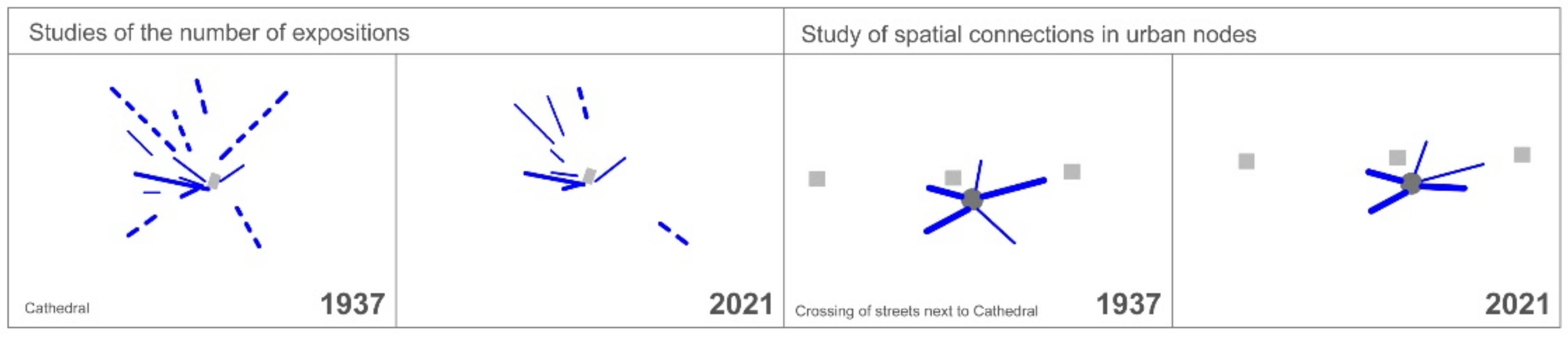
Figure 1. New streets realized near the Cathedral and the Palace in the 1960s of the 20th century (Archives of Urban Planning Department, Białystok Municipality).
Land 10 01083 g001
Figure 2. M. Skłodowska-Curie Street completed in the 1950s–1960s of the 20th century and a mixture of buildings (Archives of Urban Planning Department, Białystok Municipality).
Land 10 01083 g002
Figure 3. (a)The research area: location of the war damage; prepared by M. Chodorowski based on materials of Białystok Municipality. (b) Research area on maps of 1937 and 2021; source: (1937) National Archives in Białystok, The Plan of the District City Białystok 1937, (2021) based on Białystok Geographic Information System.
Land 10 01083 g003aLand 10 01083 g003b
Figure 4. Landmarks on research area in 1937 and 2021; prepared by M. Chodorowski.
Land 10 01083 g004
Figure 5. Nodes of urban grid on research area in 1937 and 2021; prepared by M. Chodorowski.
Land 10 01083 g005
Figure 6. Summary diagram; prepared by M. Chodorowski.
Land 10 01083 g006
Figure 7. Examples of graphic studies over the number and rank of visual expositions of the selected landmark and spatial connections of the exemplary urban node (wide lines—main directions of visual exposition; slim lines—subordinate directions of visual exposition; continuous lines—direct visual expositions; intermittent lines—indirect visual expositions. On the right: wide lines—main connections; slim line—subordinate connections). Prepared by the authors.
Land 10 01083 g007
Figure 8. The reference of the distribution of nodal points to the polygon mesh. Indication of the areas of post-war interference in the urban tissue and selection of the location of points to be examined in the next stage of compositional analysis; prepared by M. Chodorowski.
Land 10 01083 g008
Figure 9. Street network on research area in 1937 and 2021; prepared by M. Chodorowski.
Land 10 01083 g009
Table 1. Summary of changes in the number and rank, and the final balance of visual exposition directions of selected major landmarks in the research area; prepared by B. Czarnecki.
LandmarkNumber of ExpositionsExpositions BalanceTotal Balance
Main DirectSubordinate DirectMain IndirectSubordinate IndirectMain DirectSubordinate DirectMain IndirectSubordinate Indirect
1.St. Roch’s Church
1937
1208
20213112+2−1+1−6−4
2.Catholic Cathedral
1937
2373
202122230−1−50−6
3.City Hall
1937
3000
2021300000000
4.St. Nicolas Orthodox Cathedral 19371210
20212010+1−200−1
5.Visitor Palace 19371100
20210300−1+2001
6.St. Maria Madeleine Chapel 19370200
202101000−100−1
7.Theatre
1937
1000
20210100−1+1000
Total balance +1−2−4−6−11
Table 2. Investigation of spatial connections and transformations of selected nodal points; prepared by M. Chodorowski.
URBAN NODESNumber of Directions (Connections)Balance in StructureTotal BalanceTransformation of Urban Structure in Urban Nodes
MainSubordinateMainSubordinateShift of RankNewDecline
1Crossing of streets next to St. Roch’s Church30−1+10100
1937
202121
2Crossing of streets next to Cathedral32000111
1937
202132
3Crossing of streets next to City Hall400+11110
1937
202131
4Crossing of streets next to St. Nicolas Orthodox Cathedral210+11010
1937
202122
5Crossing of streets next to Palace Gate40−10−1111
1937
202130
6Crossing of Malmeda Str. with Spółdzielcza Str.03+2−20000
1937
202121
7Nowy Świat Str.21−2−1−3101
1937
202102
8Crossing of Warynskiego Str. with previous Szlachecka Str.030−1−1002
1937
202102
9Crossing of Warynskiego Str. With Czysta04000000
1937
202104
Total balance −2−1−3545
Table 3. The reference of the distribution of nodal points to the polygon mesh. Analysis of nodal points and indication of areas of interference with the urban tissue in the post-war period; prepared by M. Chodorowski.
X1Pre-war urban nodes83 X1>X2 + X3New urban grid
X2Urban nodes common for both urban grids63 X1≤ X2 ≥X3Preserved urban grid form
X3Post-war urban nodes30 X2X3Modified urban grid
X1x2x3Summary X1x2x3Summary X1x2x3Summary
A10000 B10101 C11001
A20000 B22248 C23227
A31001 B31124 C34138
A40303 B40404 C455212
A50000 B53003 C50044
A60000 B60000 C61203
A70000 B70000 C70101
A80000 B80000 C80000
1304 68620 14111136
X1x2x3Summary X1x2x3Summary X1x2x3Summary
D10101 E10000 F10000
D24509 E21203 F20000
D3134118 E34217 F34105
D448214 E4181524 F43003
D50606 E56219 F52103
D63227 E60101 F60000
D70213 E70202 F70000
D80000 E80101 F80000
2428658 2911747 92011
Publisher’s Note: MDPI stays neutral with regard to jurisdictional claims in published maps and institutional affiliations.

