Article

Analysis of the Course and Frequency of High Water Stages in Selected Catchments of the Upper Vistula Basin in the South of Poland

1
Department of Sanitary Engineering and Water Management, University of Agriculture in Krakow, Mickiewicza 24-28 Street, Krakow 30-059, Poland
2
Department of Land Reclamation and Environmental Development, University of Agriculture in Krakow, Mickiewicza 24-28 Street, Krakow 30-059, Poland
*
Author to whom correspondence should be addressed.
Water 2016, 8(9), 394; https://doi.org/10.3390/w8090394
Submission received: 12 July 2016 / Revised: 31 August 2016 / Accepted: 1 September 2016 / Published: 10 September 2016

Abstract

:
The paper presents an analysis of the course and frequency of high water stages in selected catchments of the upper Vistula basin in the south of Poland. The following rivers were investigated: the Dunajec–Nowy Targ-Kowaniec cross-section, the Rudawa–Balice cross-section, the Kamienica–Nowy Sącz cross-section, the Wisłok–Tryńcza cross-section and the San–Przemyśl cross-section. Daily flows from the years 1983–2014 were used to determine maximum annual flows and maximum flows per summer and winter half-year. Selected floods were analyzed with reference to the following metrics: POTX (mean size of the flow determined based on high water stages exceeding the assumed threshold value), POT3F (number of high water stages exceeding the threshold value for each hydrological year), WPOT3F (number of high water stages exceeding the threshold value for the winter half-year and), LOPT3F (number of high water stages exceeding the threshold value for the summer half-year). The determined metrics were analyzed for trend (Mann-Kendall test), homogeneity (Kruskal-Wallis test), and heteroscedasticity (Levene test). Additionally, periodograms were used to determine periodicity of time series for maximum annual flows. The resulting computations indicated upward trends in the analyzed flood metrics but they were not significant in any case. Therefore, in the years 1983–2014 no factors were observed that would significantly affect the size and frequency of high water runoff from the investigated catchments.

1. Introduction

The effects of climatic changes on the formation of extreme hydrological events and their frequency have been increasingly scrutinized as of late due to their environmental, social, and economic importance. Particular attention has been paid to the discharges resulting in floods that cause short-term or long-term negative social and environmental changes [1,2,3,4]. Reliability of a database used for determination of high water frequency is crucial for flood risk analysis [5].
Raised water stage is a complex event caused by variable climatic and physiographic characteristics of a catchment. Svensson et al. [6] and Hattermann et al. [7] claimed that the effects of climatic changes on the formation of high water flows and their frequency include mainly the amount of precipitation, its spatial distribution, and prevalence, as well as fluctuations of mean air temperature responsible for snowmelt.
The impact of climatic changes on the size and frequency of extreme flows has become a popular research topic, as evidenced by numerous studies investigating this problem [8]. Lindstrom and Bergstrom [9] found significant upward trends in the size of high water stages in the rivers of Northern Europe. A study by Villarini et al. [10] did not show any significant changes in the seasonality of maximum annual flows in the central Europe in the last 75 years. Mudelsee et al. [11], who examined a long series of daily flows on the Elbe and the Oder, showed a reduction in the incidence of maximum flows in the winter half-year and a lack of trend in the summer half-year. Studies by Kundzewicz et al. [12], demonstrated significant growing trends for maximum annual flows in 11 out of 70 investigated European rivers. Also, Hirabayashi et al. [13] suggested that the predicted climatic changes would result in shortening the intervals between subsequent raised water stages and floods in Central and Eastern Europe, including Poland. Furthermore, daily maximum flows are expected to increase by 3 to 4 times as compared with the 20th century. Douglas et al. [14] reported an increasing occurrence of low water stages in the rivers of northeastern United States. Nka et al. [15] indicated the importance of upward trends determined for mean flows in West African rivers. Research studies conducted in China by Zhang et al. [16] focused on the relationships between precipitation height, air temperature and the amount of river runoff for the Jangcy and confirmed the role of global warming in increasing the frequency of floods in its basin. In another study, Tao et al. [17] investigated the trends in daily flows for a 50-year period in the rivers within the Tarim basin and analyzed the effects on climatic changes on the hydrological regime. A recent study by Asadieh et al. [18], conducted in the USA in the multi-year period of 1971–2001, pointed out very similar relative changes in extreme runoff and mean runoff, in terms of global and continental averages. However, the extreme runoff showed relatively faster rate of change compared to the mean runoff (and streamflow).
Current hydrological regime of Polish rivers has been thoroughly investigated and described, but mean and extreme values for long-term runoff trends are still under scrutiny [19]. An example of ongoing investigation is the report of Banasik and Hejduk [20] that included 48 annual events of rainfall and runoff in agricultural catchment of the Zagożdżonka and showed a lack of trend in rainfall and a decreasing trend in runoff (about 1.2 mm per year) by using the Mann-Kendall test. In another study, Banasik et al. [21] analyzed the impact of climatic factors on the changes in water resources in a small river catchment located in Puszcza Kozienicka forest. Kundzewicz et al. [22] examined changes in selected climatic factors and their effects on flood size in the catchments located in the northern part of the Tatra Mountains.
Hydrological studies use numerous metrics facilitating data trend analyses. A commonly used index is the annual maximum daily mean river flow, i.e., the largest daily mean flow that occurs each year [23]. However, in several years the annual maximum daily flow may be of such a modest magnitude that it cannot really be called a flood. Therefore, another option to choose is a flood index series including all independent events which exceed a threshold, so that the series contains a certain number of events per year on average. In the latter approach, such a data set, called the peak-over-threshold (POT) series, may contain more than one entry from one year and none from another year [6]. A POT series consists of a series of independent daily mean river flows that exceed a certain threshold (this threshold is the same throughout the time series). The POTs have to be proper peaks, i.e. the river flow both before and after the peak has to be lower than at the peak itself [12,24].
Taking into account progressive climatic changes that may significantly affect the size and frequency of high water levels, the aim of this study was to analyze the correct course of the elements characteristic of these extreme flows. The evaluation was based on the observed trends for the examined indicators describing the distribution of high water stages.

2. Characterization of Study Catchments

The study included five elementary catchments of the Carpathian rivers located in the upper Vistula basin (Figure 1): the Dunajec–Nowy Targ-Kowaniec cross-section (1), the Rudawa–Balice cross-section (2), the Kamienica–Nowy Sącz cross-section (3), the Wisłok–Tryńcza cross-section (4) and the San–Przemyśl cross-section (5). The Dunajec is one of the largest right-hand tributaries of the Vistula. Downstream of the Nowy Targ-Kowaniec cross-section (below the merge point of the Biały Dunajec and the Czarny Dunajec), its catchment covers an area of 681 km2 and is located in the southern part of the Małopolska region in Nowy Targ and Zakopane districts (Figure 1). In abiotic terms, the Biały Dunajec and the Czarny Dunajec are Tatra carbonate streams (type 2) in their source sections, then become Tatra siliceous streams (type 1) and, after merging, they form a type 14 flysch river. The catchment of the Rudawa (Figure 1), a left-hand tributary of the Vistula, covers downstream of the Balice cross-section an area of 289 km2 and is located in the northwestern part of the Małopolska region, within Kraków district. From its source down to the Racławka, it is a small, coarse substrate-dominated calcareous highland stream (type 7) that is further transformed into a small calcareous type 9 highland river. The catchment of the Kamienica covers the area of 237 km2 and is located in the southeastern part of the Małopolska region, in Nowy Sącz district. Its sources are located on the north side of Jaworzyna Krynicka massif, and it is the right-hand tributary of Dunajec with which it merges at the bottom Kotlina Sądecka in Nowy Sącz. The Kamienica marks a boundary between two picturesque regions, i.e., Beskid Niski on its northeastern side and Beskid Sądecki on its southwestern side. The Kamienica is a braided river engineered in its lower course. Its typically highland character is manifested by suddenly raised water stages occurring after intense rainfall that cause a flood risk. In abiotic terms, it is a type 12 flysch river. The Wisłok river is 220 km long and its catchment downstream to the Tryńcza cross-section covers 3524 km2. It is a left-hand tributary of the San (Figure 1). Its catchment is located in the southeastern part of Poland, in the Subcarpathian region.
In its upper course, the Wisłok is a highland river with swift stream and rocky bottom with numerous gorges. Its sources are located in Beskid Niski, on the slopes of Wielki Bukowiec, at 770 m a.s.l. The Wisłok is highly diverse in abiotic terms: in the source section it is a flysch stream (type 12), from the Besko reservoir until the Stobnica it is a small flysch river (type 14), then until the Rzeszów reservoir it is a mid-sized highland east river (type 15), and in its lower course it is a sand and loam-dominated lowland river (type 19). The San is a right-hand tributary of the Vistula (Figure 1). Its sources are located in the Western Bieszczady Mountains (Ukraine) on the slopes of Piniszakowy, at 925 m a.s.l. The San catchment until the Przemyśl cross-section covers 3686 km2 and spreads over the area belonging to a few districts of the Subcarpathian region. In abiotic terms, the San from the source to the mouth of the Wołowaty stream is a type 12 flysch stream , then at the section until Solina reservoir it is a small flysch river (type 14), and it reaches the gauged cross-section as a mid-sized highland east river (type 15).

3. Materials and Methods

The presented hydrological analysis was based on observation series of daily flows (Qd) from a multi-year period of 1983–2014 received from the Institute of Meteorology and Water Management PIB in Warsaw. These data were used to determine mean flows of the multi-year period, and then the trends for the metrics describing high water stages were evaluated and an analysis of statistical homogeneity and variance was performed. To the analysis of homogeneity and variance, the observed series of maximum annual flows and examined metrics were divided into two samples with 16 observations each. The division of the analyzed multi-year period was based on knowledge of meteorological and hydrological local conditions. In the period 1983–1998, there were dry and extremely dry years, whereas the period 1999–2014 is characterized by wet and extremely wet years [25]. There was no need to correct for the assumed significant level; only three tests were used in this study, and the increase of probability type II errors did not assume a significant level [26]. Additionally, periodograms were used to determine periodicity of the time series of maximum annual flows.

3.1. Trend Detection for High Water Stage Metrics

An analysis of seven metrics of high water stages determined based on Qd observations was performed for each of the investigated rivers. The observations were as follows: maximum annual flow (Qmax), maximum flow of the winter half-year (Qmax;w), and maximum flow of the summer half-year (Qmax;s). A threshold value serving as a benchmark for high water stages selection (peak over threshold—POT) was established, taking into account the data from Table 1. As all the catchment areas were smaller than 45,000 km2, the analysis included high water stages separated from each other by at least five-day time intervals [24]. The selected flows were used to determine the following metrics: POTX, POT3F, WPOT3F, and SPOT3F (Table 1). Values of POTX were calculated, based on selected floods. Episodes were identified and assumed for further analysis. The mean flow was assumed, because only episodes which dominated supply by surface runoff against supply by groundwater were analyzed. Next, the values of POT3F, WPOT3F and SPOT3F were assumed, which were above thevalues of flood, which was on position about 1/3 in number of distribution, which was designated for all years [27].
Significance of the trend for the analyzed metrics describing high water stages was assessed with a non-parametric Mann-Kendall test. The null hypothesis for these tests is that there is no trend in the series and data in the series are independent. The minimum size of sample for the Mann-Kendall test could be below ten observations. The Mann-Kendall S statistic for a time series is determined from the equation [18,28,29,30]:
S = k = 1 n 1 j = k + 1 n s i g n ( x j x k )
where
s i g n ( x j x k ) = { 1   f o r   ( x j x k ) > 0   0   f o r   ( x j x k ) = 0 1   f o r   ( x j x k ) < 0
where n: number of the time series elements.
A normalized test statistic Z is defined by the equation:
Z = S s i g n ( S ) V a r ( S ) 1 / 2
where Var (S): variance S is defined by the equation:
V a r ( S ) = 1 18 · ( n · ( n 1 ) · ( 2 n + 5 ) )
When there are recurring elements in the observation series, the formula is completed upon correction:
V a r ( S ) = 1 18 · ( n · ( n 1 ) · ( 2 n + 5 ) ) i = 1 g t p · ( t p 1 ) · ( 2 t p + 5 )
where g: the number of tied groups; tp: the number of observations in the p-th group.
Variance was used to work out the probability associated with the normalized test statistic Z. A trend is recognized as growing if the Z statistic is positive, or as decreasing if the Z statistic is negative. When the calculated test probability p is lower than the assumed significance level (in this study α = 0.05), the analyzed trend is considered significant.

3.2. Homogeneity of Statistical Data

Statistical homogeneity of the data was determined using a non-parametric Kruskal-Wallis test. The inference involved assigning rank to the ordered elements of all samples and determination of rank sum for each sample. When differences between the analyzed sums are small, the null hypothesis (H0) assuming that all samples originate from the same general population (are homogeneous) is true. A critical region was defined by Pearson’s statistic χ2 with k − 1 degrees of freedom (where k is number of compared samples) [31]. In this paper, the Kruskal-Wallis test was also used to establish the significance of differences between the analyzed metrics describing high water stages. The null hypothesis H0 was verified for the significance level α = 0.05.

3.3. Heteroscedasticity

Heteroscedasticity was assessed with the non-parametric Levene’s W test statistic that Levene’s test is used to test if k samples have equal variances. Equal variance across samples is called homogeneity of variance. Given a variable Y with sample of size N divided into k subgroups, where Ni is the sample size of the ith subgroup; the Levene test statistic is defined as [32]:
W = ( N k ) i = 1 k N i ( N i Z ) 2 ( k 1 ) i = 1 k j = 1 N i ( Z i j Z i ) 2
where W: results of test; k: is the number of different groups to which the sampled cases belong; N: is the total number of cases in all groups; Ni: is the number of cases in the ith group; Yij: is the value of the measured variable for the jth case from the ith group; Zij can have one of the following two definitions: Zij = |Yij- Y i ¯ | where Y i ¯ is the mean of the i-th subgroup; Zij =|Yij- Y i ˜ | where Y i ˜ is the median of the i-th subgroup; Z..: is the mean of all Zij; Zi: is the mean of the Zij for group i.
The Levene test rejects the hypothesis that the variances are equal if W > Fα, k−1, N−k where Fα, k−1, N−k is the upper critical value of the F distribution with k − 1 and Nk degrees of freedom at a significance level of α.

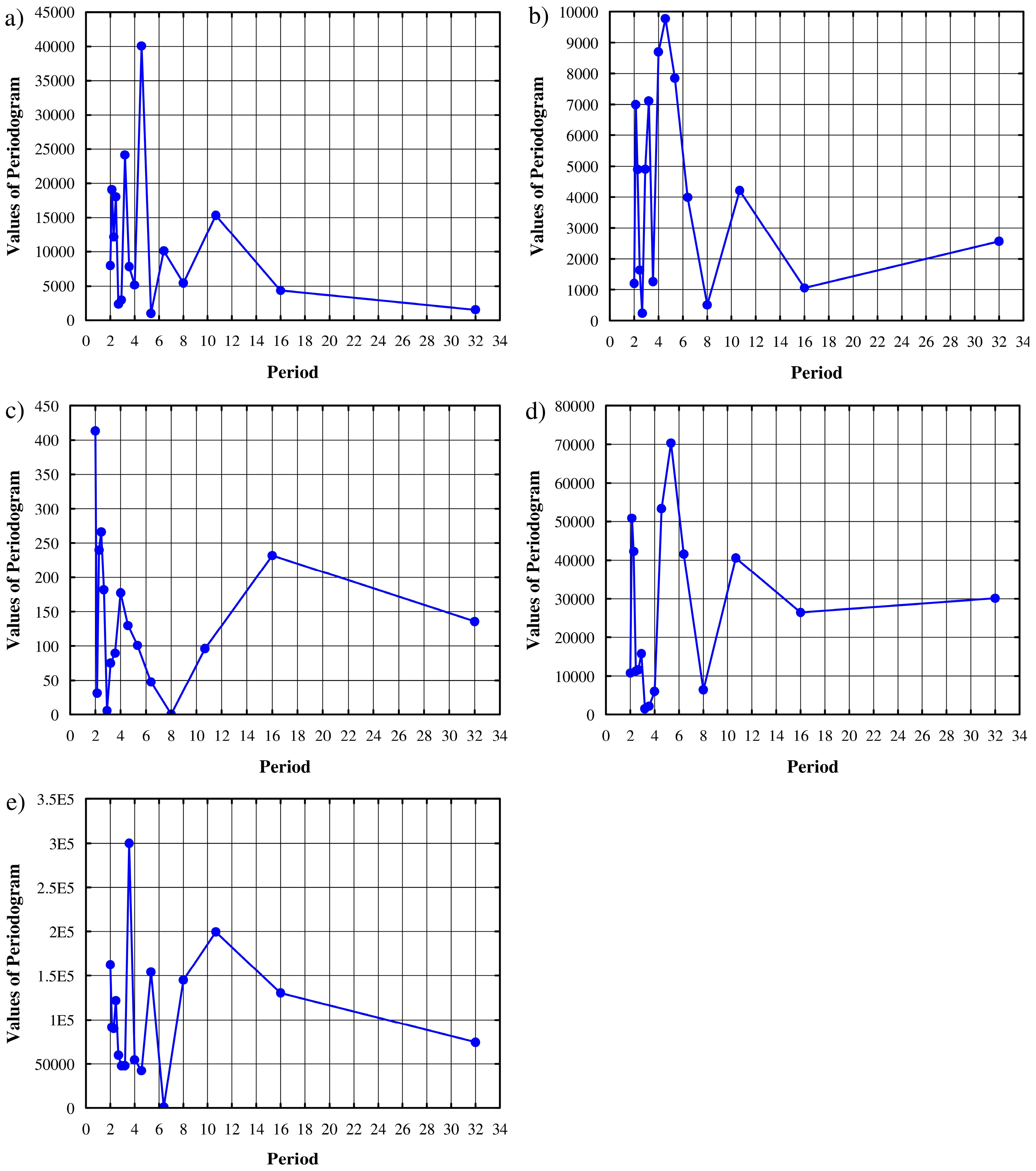
3.4. Time Series Periodicity

Periodicity of Qmax time series in the catchments of the analyzed rivers was assessed using a spectral analysis designed to investigate the harmonic structure of a time series. The aim of the analysis is to break down a complex time series containing cyclical elements into a few basic sinusoidal functions (sine and cosine) with specific wavelengths. This analysis allows for discovering a few periodic cycles of variable length that at first appeared to be more or less random noise. A general model of the spectral function might be described with multiple regression function [33]:
X t = a 0 + [ a k · cos ( λ k · t ) + b k · sin ( λ k · t )   f o r   k   ϵ   ( 1 ,   q )
where Xt: value of a random variable at t time; a0: free term; ak and bk: regression coefficients; λk: frequency; t: time; q: number of variables in a model related to the number of data in a series.
The results of the spectral analysis were presented in a periodogram. Random fluctuations were smoothed via a weighted moving average transformation according to Hamming. The periodogram showed how the time series variance was distributed between individual frequencies [34].

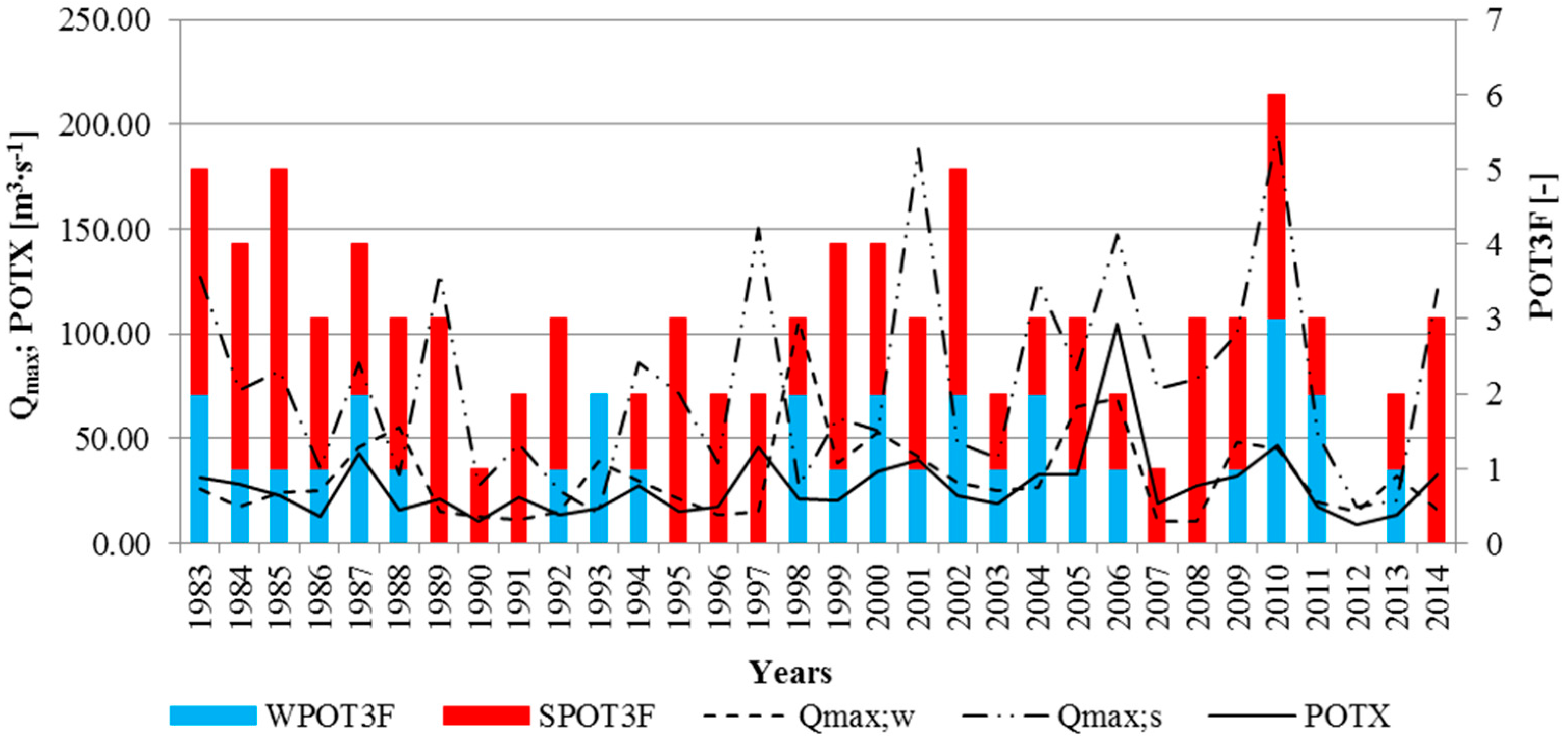
4. Results and Discussion

The study analyzed the following hydrological metrics determined from the hydrometric data: Qmax, Qmax;w, Qmax;s, POTX, POT3F, WPOT3F, and SPOT3F. The values of the metrics describing high water stages for the Dunajec at the Nowy Targ-Kowaniec cross-section are displayed in Figure 2. Qmax for the Dunajec was found to be very variable. The lowest maximum flow (33.30 m3∙s−1) was observed for the winter half-year of 2012, and the highest (317.00 m3∙s−1)—which was over eight times greater—for the summer half-year of 1997. In most cases, the observed annual maxima were caused by rainfall and this explains their occurrence in the summer half-year. The lowest POTX (29.10 m3∙s−1) was reported for 2012, and the highest (118.20 m3∙s−1) for 2000. In the years 1983–2014, 81 high water stages exceeding the threshold value were recorded for the Dunajec. Nearly 80% of them happened in the summer half-year. The highest number of high water stages, i.e., five per year, was observed in 1985 and 2010.
Figure 3 summarizes the metrics describing high water stages in the Rudawa at Balice cross-section.
An analysis of the results presented in Figure 3 revealed a substantial, nearly nine-fold difference between the lowest and the highest observed Qmax. The lowest Qmax occurred in 1992, amounting to 3.72 m3∙s−1 (winter half-year), and the highest Qmax, amounting to 32.90 m3∙s−1, was recorded in the summer half-year of 2010. In the years 1983–2014, Qmax was mainly observed for winter high water stages. The lowest POTX of 3.28 m3∙s−1 was observed in 1984, and the highest of 17.95 m3∙s−1 in 1997. In the analyzed multi-year period, there were 85 high water stages in the Rudawa exceeding the threshold value, 46 of which occurred in the winter half-year and the rest in the summer half-year. The highest number of high water stages (eight events) was observed in 2010. The period of 1988–1993 featured very low values of flood-related metrics. This was probably due to extremely low precipitation. The catchment of the Rudawa is a highland area with high retention capacity where even incidental intense precipitation does not cause floods. High retention capacity of the Rudawa means that the flood-related metrics follow a more regular course than in the mountain catchments. Figure 3 presents two distinct periods of the WPOT3F and SPOT3F course: the years 1983–1990 and 1993–2014.
Figure 4 shows the changes in the metrics describing high water stages for the Kamienica at Nowy Sącz cross-section.
For the Kamienica (Figure 4), a significant, i.e., over 11-fold difference, between the lowest and the highest Qmax was found in the multi-year period 1983–2014. The lowest Qmax (17.40 m3∙s−1) was reported for the winter half-year of 2012, and the highest (196.00 m3∙s−1) for the summer half-year of 2010. The difference is height of precipitation in this years. The year 2010 was extremely wet (about 160% normal precipitation height for this catchment), while 2012 was a normal year (about 90% of normal precipitation height for this catchment). In the analyzed study period, as many as 87% of Qmax flows occurred in the summer half-year. The lowest POTX of 9.25 m3∙s−1 was observed in 2012, and the highest of 104.95 m3∙s−1 in 2006. An analysis of Figure 4 revealed that over the investigated 32 years there were 94 high water stages in the Kamienica that exceeded the adopted threshold value, and 62 of them occurred in the summer half-year. The highest number of high water stages (six events) was observed in 2010. No high water stages were observed in 2012 due to hydrological drought.
Figure 5 summarizes the metrics describing high water stages in the Wisłok at Tryńcza cross-section. An inspection of the values presented in Figure 5 demonstrated a nearly eight-fold difference between the lowest and the highest observed Qmax. The lowest Qmax occurred in 1990 and it amounted to 69.50 m3∙s−1 (winter half-year), and the highest Qmax—554.00 m3∙s−1—was recorded in the summer half-year of 2010. The majority (57%) of Qmax flows in the examined multi-year period were due to snowmelt. An analysis of POTX changes revealed a range of values from 47.33 m3∙s−1 in 1990 to 258.60 m3∙s−1 in 2010. In the years 1983–2014, there were 88 high water stages in the Wisłok that exceeded the threshold value, and 57% of them occurred in the winter half-year. The highest number of high water stages (six events) was observed in 2001.
Figure 6 presents the changes in the metrics describing high water stages in the San at Przemyśl cross-section.
Figure 6 indicates a nearly seven-fold difference in the observed Qmax. The lowest flow of 140.00 m3∙s−1 was recorded in the summer half-year of 1995, and the highest of 945.00 m3∙s−1 in the winter half-year of 1998. Most of the observed Qmax (19 events) were reported in the summer half-year. The lowest value of POTX (92.50 m3∙s−1) was determined in 1990, and the highest (324.00 m3∙s−1) in 2000. In the investigated multi-year period, there were 95 high water stages in the San that exceeded the threshold value, and 55% of them occurred in the summer. The highest number of high water stages (eight events) was observed in 1998 and 2010.
The highest values of Qmax in the investigated river catchments were recorded in 1997, 1998 and 2010. These are the years in which Poland was fighting devastating floods. The flood of July 1997 was caused by intense rainfall that occurred in the area of the Carpathian tributaries of the Vistula, from the Mała Wisła to the Dunajec. At that time, the sum of daily rainfall reached maximum values of the multi-year period. In April 1998, the floods hit mostly the catchments of the Dunajec, the Wisłok, and the San. This disaster, similarly as in 1997, was caused by intense days-long rainfall, and the rainfall size in April was over 300% of the monthly average [35]. A catastrophic flood happened at the turn of May and June 2010 in the upper Vistula basin; it was the greatest flood in the history of hydrological measurements of this river. It was caused by the rains that lasted for most of May. Until then, the rains causing the greatest floods in the Carpathian Mountains occurred usually in July on a large area and they were of a continuous nature. The rains in May 2010 were considered unique, as they were accompanied by the pressure systems that usually bring about the intense rainfall characteristic of the summer months [36]. Additionally, mountain catchments of flysch type are dominated by summer high water stages, whereas in highland catchments, the number of summer and winter floods is similar.
Increasing incidence of flood flows makes the detection of Qmax trend a popular subject of scientific and practical interest. It is indispensable for planning and designing future flood protection systems, as the assumed stability of the conditions controlling the runoff of high water from a catchment seems debatable in the light of advancing climatic changes [12]. The next chapters of the study are devoted to the analysis of the trends in the investigated metrics that describe the course of high water stages in the selected river catchments. Table 2 shows the trend significance results yielded by Mann-Kendall test.
The results presented in Table 2 demonstrated that test probability p was in all the cases higher than 0.05 and this indicated a lack of significance of the trends for these metrics (Table 2). Similar findings were published by Walega et al. [37,38], who examined the significance of a trend for medium (SQ) and low (NQ) flows in the catchments of the upper Vistula basin. The study confirmed the presence of trends but they were not significant. A similar assessment was described in a paper by Walega and Młyński [39] that analyzed the homogeneity of Qmax in the catchments of the Lepietnica and the Koprzywianka. The study also demonstrated an existing but statistically insignificant trend for extreme flows. The study outcomes summarized in Table 2 confirm the observations reported in other works related to the climatic changes in the selected catchments of the upper Vistula basin. Pińskwar [40] and Niedźwiedź et al. [41] discovered upward trends in the analyzed metrics of daily rainfall that were, however, not significant again. Also Falarz [42], who investigated the time of snow cover presence, observed a downward but insignificant trend for this phenomenon. Similarly, Kundzewicz et al. [22] reported that the presence of trends for climatic variables controlling high water stages may usually be detected but they were not significant. Lack of trend of the mentioned characteristics of climate change significantly affects the hydrological regime of rivers. Supply of rivers in Poland is snowy-rainy, with a lower supply of the flowing groundwater. Hence this phenomenon could affect the lack of trend of investigated rivers [43].
The study was complemented by the assessment of homogeneity and heteroscedasticity of high water stage metrics Qmax, POTX, and POT3F. Table 3 summarizes the results of Kruskal-Wallis and Levene tests conducted for the significance level α = 0.05.
The outcomes of Kruskal-Wallis test for the years 1983–1998 and 1999–2014 indicated no reasons to reject the null hypothesis (H0) assuming homogeneity of the analyzed data for the Dunajec, the Kamienica, and the San. This was evidenced by the values of χ2 that were smaller than the value adopted during defining the critical region (for two compared samples: χ2kr = 3.841). This means that the analyzed random variables originated from the same general population. It was therefore concluded that no significant factor affecting the course of processes controlling high water runoff from the study catchments has appeared in the analyzed multi-year period. Contrary to this, χ2 and p determined for the Rudawa (Qmax) and the Wisłok (POTX) indicated significant differences between the studied samples. Significant differences in Qmax for the Rudawa were due to the fact that in the multi-year period 1983–1998 there were less water-abundant years than in the period of 1999–2014. An analysis of heteroscedasticity (Levene W test) of the investigated high water stage metrics for the years 1983–1998 and 1999–2014, confirmed the null hypothesis H0 that assumed a lack of significant differences between the variances. Therefore stability of the hydrological regime has been confirmed for the investigated catchments.
Another element investigated in this study was the periodicity of Qmax time series for the study catchments. This was performed using spectral analysis designed for evaluation of the harmonic structure of a time series. The analysis outcomes are presented in Figure 7.
An analysis of periodicity of Qmax time series for the investigated river catchments demonstrated approximately five-year cycles of Qmax in the Dunajec (Figure 7a). Moreover, shorter three-year cycles with smaller peak values were also observed. The periodograms for the Kamienica Nawojowska (Figure 7b) revealed the same cycles as for the Dunajec. The Kamienica Nawojowska is located within the Dunajec basin and this explains the observed repeatability. Furthermore, these rivers are characterized by mountain regime that may disrupt cycles of the investigated phenomenon. For the Rudawa (Figure 7c), two-year cycles of Qmax were reported. Additionally, longer 16-year cycles with lower Qmax were detected. For the Wisłok (Figure 7d), five-year cycles of Qmax and a shorter one of two years were observed, similar to the Dunajec and the Kamienica. The periodogram for the San (Figure 7e) indicated four-year cycles and longer ten-year periods with lower Qmax.

5. Conclusions

The study analyzed the changes in high water stage metrics in the multi-year period 1983–2014 for the selected catchments of the upper Vistula basin. The research yielded the following conclusions:
  • Long-term hydrometric measurements conducted in the study catchments usually indicated upward trends for maximum flows and increasing incidence of high water stages. However, these trends were not significant.
  • No significant differences in high water stage metrics were detected for the Dunajec, the Kamienica, and the San. Therefore, it may be concluded that no factor significantly affecting the runoff of high water from these catchments has appeared in the investigated multi-year period. Significant differences between the analyzed metrics (Qmax and POTX) were detected for the Rudawa and the Wisłok, respectively. Additionally, no significant differences in the variances for these metrics were found in each of the cases.
  • Although the detected trends were not significant, the hydrological parameters and meteorological factors should be still monitored in order to capture any changes in the trend significance and the factors affecting their fluctuations.
  • Spectral analysis indicates that Qmax shows the same cyclic behavior in the five analyzed basins.

Acknowledgments

The authors would like to thank Dean of the Faculty of Environmental Engineering and Land Surveying, University of Agriculture in Krakow, for financial support. We would like to thank the Institute of Meteorology and Water Management National Research Institute for daily flow data. We thank the anonymous reviewers for their constructive comments which helped to substantially improve the manuscript.

Author Contributions

Andrzej Wałęga worked out the study methodology and the literature review. Dariusz Młynski made calculations and participated in preparation of the manuscript. Tomasz Kowalik prepared watershed characteristics, and Andrzej Bogdał participated in the results and discussion.

Conflicts of Interest

The authors declare no conflict of interest.

References

  1. Du, S.; Gu, H.; Wen, J.; Chen, K.; Van Rompaey, A. Detecting flood variations in Shanghai over 1949–2009 with Mann-Kendall Tests and a Newspaper-Based Database. Water 2015, 7, 1808–1824. [Google Scholar] [CrossRef]
  2. Kundzewicz, Z.W. Change detection in high river flows in Europe. In Proceedings of the Symposium S6 Held during the Seventh IAHS Scientific Assembly, Foz do Iguaçu, Brazil, 3–9 April 2005; pp. 71–80.
  3. Kundzewicz, Z.W.; Ulbrich, U.; Brucher, T.; Graczyk, D.; Kruger, A.; Leckebusch, G.C.; Menzel, L.; Pińskwar, I.; Radziejewski, M.; Szwed, M. Summer floods in Central Europe—Climate change track? Nat. Hazards 2005, 36, 165–189. [Google Scholar] [CrossRef]
  4. Perju, E.R.; Zahara, L. Changes in the frequency and magnitude of floods in the Bucegi Mountains (Romanian Carpathians). In Proceedings of the Water Resources and Wetlands, Tulcea, Romania, 11–13 September 2014; pp. 321–328.
  5. Mendez, F.J.; Mendez, M.; Luceno, A.; Losada, I.J. Estimation of the long-term variability of extreme significant wave height using a time-dependent Peak over Threshold (POT) model. J. Geophys. Res. 2006, 111, 1–13. [Google Scholar] [CrossRef]
  6. Svensson, C.; Hannaford, J.; Kundzewicz, Z.W.; Marsh, T.J. Trends in river floods: Why is there no clear signal in observations? Front. Flood Res. (IAHS Publ.) 2006, 305, 1–8. [Google Scholar]
  7. Hattermann, F.F.; Kundzewicz, Z.W.; Huang, S.; Vetter, T.; Gerstengarbe, F.W.; Werner, P. Climatological drivers of changes in flood hazard in Germany. Acta Geophys. 2013, 61, 463–477. [Google Scholar] [CrossRef]
  8. Tian, P.; Zhao, G.; Li, J.; Tian, K. Extreme value analysis of stream flow time series in Poyang Lake Basin, China. Water Sci. Eng. 2011, 4, 121–132. [Google Scholar]
  9. Lindström, G.; Bergström, S. Runoff trends in Sweden 1807–2002. Hydrol. Sci. J. 2004, 49, 69–83. [Google Scholar] [CrossRef]
  10. Villarini, G.; Smith, J.A.; Serinaldi, F.; Ntelekos, A.A. Analyses of seasonal and annual maximum daily discharge records for central Europe. J. Hydrol. 2011, 399, 299–312. [Google Scholar] [CrossRef]
  11. Mudelsee, M.; Börngen, M.; Tetzlaff, G.; Grünewald, U. Extreme floods in central Europe over the past 500 years: Role of cyclone pathway “Zugstrasse Vb”. J. Geophys. Res. 2004, 109, 689–693. [Google Scholar] [CrossRef]
  12. Kundzewicz, Z.W.; Graczyk, D.; Maurer, T.; Pińskwa, I.; Radziejewski, M.; Svensson, C.; Szwed, M. Trend detection in river flow series: 1. Annual maximum flow. Hydrol. Sci. J. 2005, 50, 797–810. [Google Scholar] [CrossRef]
  13. Hirabayashi, Y.; Kanae, S.; Emori, S.; Oki, T.; Kimoto, M. Global projections of changing risks of floods and droughts in a changing climate. Hydrol. Sci. J. 2008, 53, 754–773. [Google Scholar] [CrossRef]
  14. Douglas, E.M.; Vogel, R.M.; Kroll, C.N. Trends in floods and low flows in the United States: Impact of spatial correlation. J. Hydrol. 2000, 240, 90–105. [Google Scholar] [CrossRef]
  15. Nka, B.N.; Oudin, L.; Karambiri, H.; Paturel, J.E.; Ribstein, P. Trends in floods in West Africa: Analysis based on 11 catchments in the region. Hydrol. Earth Syst. Sci. 2015, 19, 4707–4719. [Google Scholar] [CrossRef]
  16. Zhang, Q.; Jiang, T.; Gemmer, M.; Becker, S. Precipitation, temperature and runoff analysis from 1950 to 2002 in the Yangtze Basin, China. Hydrol. Sci. J. 2005, 50, 65–80. [Google Scholar]
  17. Tao, H.; Gemmer, M.; Bai, Y.; Su, B.; Mao, W. Trends of stream flow in the Tarim River Basin during the past 50 years: Human impact or climate change? J. Hydrol. 2011, 400, 1–9. [Google Scholar] [CrossRef]
  18. Asadieh, B.; Krakauer, N.Y.; Fekete, B.M. Historical trends in mean and extreme runoff and streamflow based on observations and climate models. Water 2016, 8, 189. [Google Scholar] [CrossRef]
  19. Piętka, I. Long-term variations of spring runoff of Polish rivers. Prace Studia Geograficzne 2009, 43, 81–95. (In Polish) [Google Scholar]
  20. Banasik, K.; Hejduk, L. Long-term changes in Runoff from a Small Agricultural catchment. Soil Water Res. 2012, 7, 64–72. [Google Scholar]
  21. Banasik, K.; Hejduk, L.; Hejduk, A.; Kaznowska, E.; Banasik, J.; Byczkowski, A. Long-term variability of runoff from a small catchment in the region of the Kozienice Forest. Sylwan 2013, 158, 578–586. (In Polish) [Google Scholar]
  22. Kundzewicz, Z.W.; Stoffel, M.; Kaczka, R.J.; Wyżga, B.; Niedźwiedź, T.; Pińskwar, I.; Ruiz-Villanueva, V.; Łupikasza, E.; Czajka, B.; Ballesteros-Canovas, J.A.; et al. Floods at the northern foothills of the Tatra Mountains—A Polish-Swiss research project. Acta Geophys. 2014, 62, 620–641. [Google Scholar] [CrossRef]
  23. Chowdhury, R.K.; Eslamian, S. Climate change and hydrologic modeling. In Handbook of Hydrology: Modelling, Climate Change and Variability; Eslamian, S., Ed.; CRC Press: London, UK, 2014; pp. 71–86. [Google Scholar]
  24. Svensson, C.; Kundzewicz, Z.W.; Maurer, T. Trend detection in river flow series: 2. Flood and low-flow index series. Hydrol. Sci. J. 2005, 50, 811–824. [Google Scholar] [CrossRef]
  25. Wałęga, A.; Młyński, D. Assesment of seasonal occurance of minimum flow for mountain river by Colwell indices. Infrastruktura Ekologia Terenów Wiejskich 2016, 2, 557–568. (In Polish) [Google Scholar]
  26. Gyorffy, B.; Gyorffya, A.; Tulassay, Z. The problem of multiple testing and its solutions for genom-wide studies. Orvosi Hetil. 2005, 146, 559–563. [Google Scholar]
  27. Petrow, T.; Merz, B. Trends in flood magnitude, frequency and seasonality in Germany in the period 1951–2002. J. Hydrol. 2009, 371, 129–141. [Google Scholar] [CrossRef]
  28. Yue, S.; Pilon, P. A comparison of the power of the t test, Mann-Kendall and bootstrap tests for trend detection. Hydrol. Sci. J. 2004, 49, 21–37. [Google Scholar] [CrossRef]
  29. Rutkowska, A.; Ptak, M. On certain stationary tests for hydrological series. Stud. Geotech. Mech. 2012, 34, 51–63. [Google Scholar]
  30. ÇiÇek, I.; Duman, N. Seasonal and annual precipitation trends in Turkey. Carpath. J. Earth Environ. Sci. 2015, 10, 77–84. [Google Scholar]
  31. Jones, J.J.A.; Liu, C.; Woo, M.; Kung, H. Regional Hydrological Response to Climate Change; Kluwer Academic Publisher: London, UK, 1996. [Google Scholar]
  32. Levene, H. Robust tests for equality of variances. In Contributions to Probability and Statistics: Essays in Honor of Harold Hotelling; Olkin, I., Hotteling, H., Eds.; Stanford University Press: Redwood City, CA, USA, 1960; pp. 278–292. [Google Scholar]
  33. Walega, A.; Michalec, B. Characteristics of extreme heavy precipitation events occurring in the area of Cracow (Poland). Soil Water Res. 2014, 9, 182–191. [Google Scholar]
  34. Haan, C.T. Statistical Methods in Hydrology; The Iowa Stat Press: Ames, IA, USA, 2002. [Google Scholar]
  35. Bednarczyk, S.; Jarzębińska, T.; Mackiewicz, S.; Wołoszyn, E. Vademecum Ochrony Przeciwpowodziowej; Krajowy Zarząd Gospodarki Wodnej: Gdańsk, Poland, 2006; p. 326. (In Polish) [Google Scholar]
  36. Ziernicka-Wojtaszek, A.; Kaczor, G. The intensity and amount of precipitation in both the city of Krakow and the neighbouring areas during the May–June flood. Acta Scientiarum Polonorum Formatio Circumiectus 2010, 12, 143–151. (In Polish) [Google Scholar]
  37. Walega, A.; Młyński, D. Kokoszka, R. Verification of selected empirical methods for the calculation of minimum and mean flows in catchments of the Dunajec basin. Infrastruktura Ekologia Terenów Wiejskich 2014, II/3, 825–837. (In Polish) [Google Scholar]
  38. Walega, A.; Młyński, D.; Kokoszka, R.; Miernik, W. Possibilities of applying hydrological methods for determining environmental flows in select catchments of the upper Dunajec basin. Pol. J. Environ. Stud. 2015, 44, 2663–2676. [Google Scholar] [CrossRef]
  39. Walega, A.; Młyński, D. Verification of Punzet equation to calculate flood frequency in mountain and high land river in upper basin Vistula. Infrastruktura Ekologia Terenów Wiejskich 2015, IV, 873–885. (In Polish) [Google Scholar]
  40. Pińskwar, I. Projections of Changes in Precipitation Extremes in Poland; Komitet Gospodarki Wodnej PAN: Warsaw, Poland, 2010; p. 183. (In Polish) [Google Scholar]
  41. Kundzewicz, Z.; Stoffel, M.; Małarzewski, Ł. Climatological background of floods at the northern foothills of the Tatra Mountains. Theor. Appl. Climatol. 2014, 119, 273–284. [Google Scholar]
  42. Falarz, M. Long-term variability in reconstructed and observed snow coverover the last 100 winter seasons in Cracow and Zakopane (southern Poland). Clim. Res. 2002, 19, 247–256. [Google Scholar] [CrossRef]
  43. Czarnecka, M.; Nidzgorska-Lencewicz, J. Multiannual variability of seasonal precipitation in Poland. Woda-Środowisko-Obszary Wiejskie 2012, 12, 45–60. (In Polish) [Google Scholar]
Figure 1. Location of the analyzed river catchments against the upper Vistula basin: (1) the Dunajec to Nowy Targ-Kowaniec cross-section; (2) the Rudawa to Balice cross-section; (3) the Kamienica to Nowy Sącz cross-section; (4) the Wisłok to Tryńcza cross-section; (5) the San to Przemyśl cross-section (source: authors’ own studies on the basis of materials from the Regional Directorate of Water Management in Krakow).
Water 08 00394 g001
Figure 2. Qmax;s, Qmax;s, POTX, WPOT3F, SPOT3F and POT3F metrics for the catchment of the Dunajec at Nowy Targ-Kowaniec cross-section.
Water 08 00394 g002
Figure 3. Qmax;w, Qmax;s, POTX, WPOT3F, SPOT3F and POT3F metrics for the catchment of the Rudawa at Balice cross-section.
Water 08 00394 g003
Figure 4. Qmax;w, Qmax;s, POTX, WPOT3F, SPOT3F and POT3F metrics for the catchment of the Kamienica at Nowy Sącz cross-section.
Water 08 00394 g004
Figure 5. Qmax;w, Qmax;s, POTX, WPOT3F, SPOT3F and POT3F metrics for the catchment of the Wisłok at Tryńcza cross-section.
Water 08 00394 g005
Figure 6. Qmax;w, Qmax;s, POTX, WPOT3F, SPOT3F and POT3F metrics for the catchment of the San at Przemyśl cross-section.
Water 08 00394 g006
Figure 7. Periodograms of Qmax for: (a) the Dunajec; (b) the Kamienica Nawojowska; (c) the Rudawa; (d) the Wisłok; (e) the San.
Water 08 00394 g007
Table 1. Analyzed metrics of high water stages (source: authors’ own work).
MetricUnitDescription
Qmaxm3·s−1The highest flow observed during a hydrological year (max{Qmax;w; Qmaxs})
Qmax;wm3·s−1The highest flow observed during the winter half-year (1 November–30 April)
Qmax;sm3·s−1The highest flow observed during the summer half-year (1 May–30 October)
POTXm3·s−1Mean size of the flow determined based on high water stages exceeding the assumed threshold value
POT3FNumber of high water stages exceeding the threshold value for each hydrological year (ΣZPOT3F + SPOT3F)
WPOT3FNumber of high water stages exceeding the threshold value for the winter half-year (1 November–30 April)
SPOT3FNumber of high water stages exceeding the threshold value for the summer half-year (1 May–30 October)
Table 2. Evaluation of the trend of the analyzed metrics describing high water stages in the catchments of the study rivers.
MetricRangeMann-Kendall STest ZpTrend for the Significance Level α = 0.05
Dunajec–Nowy Targ-Kowaniec cross-section
Qmax [m3∙s−1]33.30–283.00540.860.28non-significant
Qmax;w [m3∙s−1]24.40–178.00200.310.38non-significant
Qmax;s [m3∙s−1]28.50–283.00520.830.28non-significant
POTX [m3∙s−1]29.10–118.20130.190.39non-significant
POT3F [–]0–5460.790.29non-significant
WPOT3F [–]0–2480.850.28non-significant
SPOT3F [–]0–5280.490.35non-significant
Rudawa–Balice cross-section
Qmax [m3∙s−1]3.72–32.90871.390.15non-significant
Qmax;w [m3∙s−1]2.68–28.20801.280.18non-significant
Qmax;s [m3∙s−1]1.82–32.90751.3200.19non-significant
POTX [m3∙s−1]3.28–17.95400.630.33non-significant
POT3F [–]0–8430.730.31non-significant
WPOT3F [–]0–4530.870.27non-significant
SPOT3F [–]0–6160.290.38non-significant
Kamienica–Nowy Sącz cross-section
Qmax [m3∙s−1]17.40–196.00250.390.37non-significant
Qmax;w [m3∙s−1]10.10–106.00260.410.37non-significant
Qmax;s [m3∙s−1]14.60–196.00290.450.36non-significant
POTX [m3∙s−1]9.25–104.95490.780.29non-significant
POT3F [–]0–6−83−1.390.15non-significant
WPOT3F [–]0–3−15−0.280.38non-significant
SPOT3F [–]0–4−101−1.700.09non-significant
Wisłok–Tryńcza cross-section
Qmax [m3∙s−1]69.50–554.00580.920.26non-significant
Qmax;w [m3∙s−1]49.90–460.00600.960.25non-significant
Qmax;s [m3∙s−1]35.80–554.00811.300.17non-significant
POTX [m3∙s−1]48.33–258.00981.570.12non-significant
POT3F [–]0–6891.500.13non-significant
WPOT3F [–]0–3701.230.19non-significant
SPOT3F [–]0–3751.300.17non-significant
San–Przemyśl cross-section
Qmax [m3∙s−1]140.00–945.00−10−0.150.39non-significant
Qmax;w [m3∙s−1]103.00–945.00190.290.38non-significant
Qmax;s [m3∙s−1]100.00–850.00210.610.73non-significant
POTX [m3∙s−1]92.50–324.00510.810.29non-significant
POT3F [–]0–850.110.40non-significant
WPOT3F [–]0–4190.320.38non-significant
SPOT3F [–]0–4190.340.38non-significant
Table 3. F and χ2 statistics for the selected high water stage metrics in the investigated river catchments.
MetricUnitValues of Tests and Probability of the Test (p)
χ2p 1Wp 1
Dunajec–Nowy Targ-Kowaniec cross-section
Qmax[m3∙s−1]0.9600.3270.0040.948
POTX[m3∙s−1]1.2780.2580.4630.501
POT3F[–]1.5110.2190.0670.797
Kamienica–Nowy Sącz cross-section
Qmax[m3∙s−1]0.2780.5981.7030.202
POTX[m3∙s−1]2.5050.1131.3280.259
POT3F[–]0.0140.9060.1750.,678
Rudawa–Balice cross-section
Qmax[m3∙s−1]3.9900.0460.0710.791
POTX[m3∙s−1]2.5660.1110.1890.667
POT3F[–]2.4130.1200.2740.604
Wisłok–Tryńcza cross-section
Qmax[m3∙s−1]1.9980.1581.6630.207
POTX[m3∙s−1]4.1430.0411.1020.302
POT3F[–]2.6810.1020.3780.543
San–Przemyśl cross-section
Qmax[m3∙s−1]0.0070.7910.2770.610
POTX[m3∙s−1]1.5470.2143.7890.061
POT3F[–]0.5940.4410.0060.936
1 Statistic significant for α = 0.05 when p ≤ 0.05.

