


Water Masses of the Mediterranean Sea and Black Sea: An Overview
Laboratory of Physical Geography, Section of Geography and Climatology, Department of Geology and Geoenvironment, National and Kapodistrian University of Athens, Panepistimiopolis, Zografou, 15784 Athens, Greece
Water 2023, 15(18), 3194; https://doi.org/10.3390/w15183194
Submission received: 15 June 2023
/
Revised: 24 July 2023
/
Accepted: 26 July 2023
/
Published: 7 September 2023
(This article belongs to the Topic Aquatic Environment Research for Sustainable Development)
Abstract
:This overview presents the different water masses present in the various primary and secondary marine regions of the Mediterranean Sea and Black Sea, providing information on their main physical characteristics (i.e., temperature, salinity, density), the water depths at which they have been observed and the processes involved in their formation. There is a characteristic difference in the overall hydrology of the Mediterranean Sea compared to the Black Sea, in terms of the number and characteristics of water masses and their formation processes, although they form a single (integrated) marine system. This difference is explained by the limited communication between the two seas through the Sea of Marmara and its straits (the Dardanelles and Bosporus) and by the fact that the Mediterranean Sea is a condensation basin while the Black Sea is a dilution basin; therefore, the deficit of water in the former is compensated by the inflow of Atlantic waters, while the surplus in the latter outflows to the Aegean Sea. In total, 21 different water masses have been identified in the Mediterranean Sea (excluding the Straits of Gibraltar and the Sea of Marmara) compared to the 5 water masses identified in the Black Sea (excluding the Sea of Azov). This large number of water masses is attributed to coastal morphology (i.e., presence of straits) and submarine relief (i.e., deep basin separated by shallow sills) and different formation processes.
Keywords:
Alboran; Adriatic; Ionian; Levantine; Aegean; Marmara; marine regions; temperature; salinity; density1. Introduction
The Mediterranean Sea (MED) and Black Sea (BLS), although they belong to a single (integrated) marine system, are characterised by much different hydrological regimes, being the combined outcome of their differences in terms of: (i) water balance that is negative for MED (−500 ± 100 mm/y) and positive for BLS (+850 mm/y) [1]; (ii) air-sea interaction processes (i.e., heat exchange, wind stress), (iii) internal dynamic processes (e.g., buoyancy fluxes); and (iv) the influence of the irregular seabed and coastal morphology associated with the presence of narrow passages and straits with shallow sills that control the exchange of water masses between the various sub-basins.
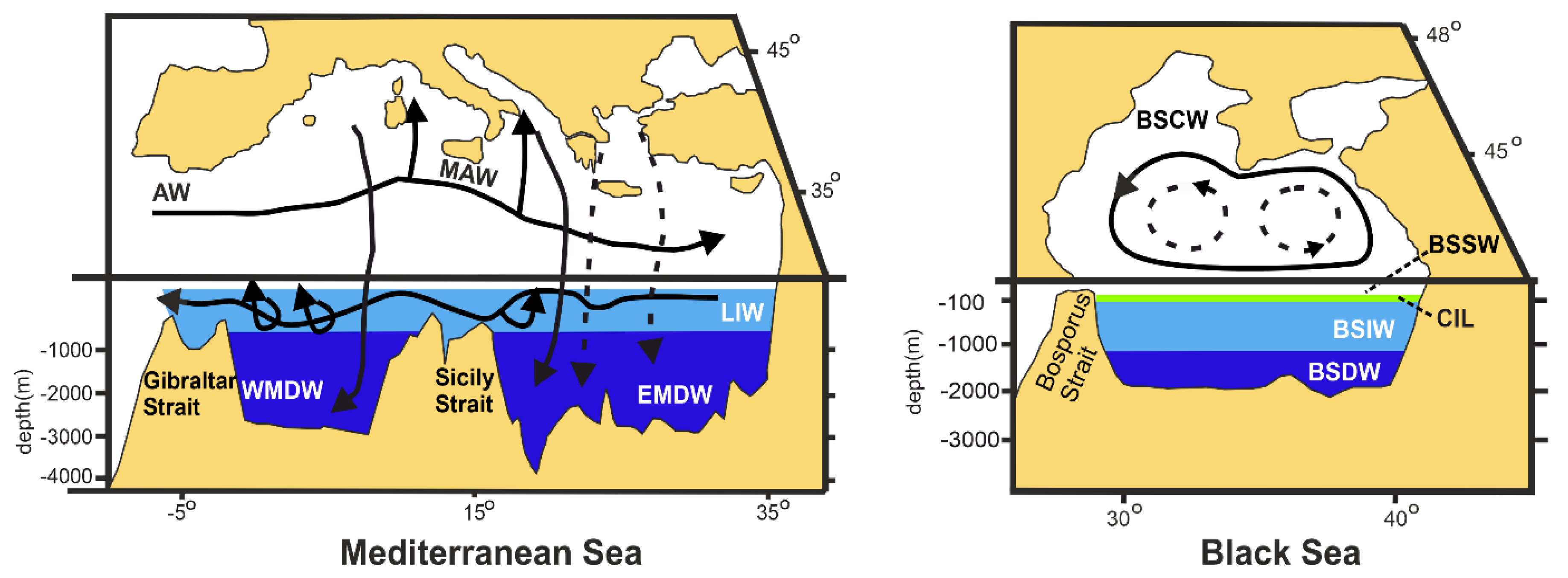
The overall circulation pattern of the surface, intermediate and deep waters in the MED is quasi-cyclonic, being associated primarily with [2,3,4,5,6,7,8,9]: (i) surface waters (upper 100–200 m) of Atlantic origin, which flow eastwards; (ii) intermediate waters (200–1000) formed in the Levantine basin and flowing westwards; and (iii) bottom waters (>1000), whose presence and renewal is the result of dense water formation processes (Figure 1).
The circulation pattern of the upper water masses of the BLA (Black Sea main basin) is also cyclonic with the presence of the peripheral Rim Current, a rather unstable cyclonic system with baroclinic and frontal instabilities [10,11,12,13,14,15] and two semi-permanent cyclonic gyres in its central part (Figure 1). Regarding deep-water circulation beneath the permanent pycnocline, Markova [16] revealed the presence (quasi-periodically in spring and summer) of anticyclonic counter currents along the northeastern continental slope at depths of about 1000 m and a number of mesoscale (of the order of several tens of kilometres) cyclonic eddies and anticyclonic deep-water vortex structures.
The first publications of the water masses of both the Mediterranean Sea and Black Sea commenced in the 1960s based on the analysis of CTD cruise data, which intensified in the 1990s. Moreover, since the beginning of the 21st century, publications have incorporated the outputs of mathematical simulations and remotely sensed data, whilst during the past two decades, additional data have been provided by sea-gliders (ARGO floats) (e.g., [16,17,18]). Usually, past investigations were restricted either to major marine regions of the Mediterranean such as the Western Mediterranean and the Eastern Mediterranean, and/or to secondary ones such as the Aegean Sea, and the Adriatic Sea. In the case of the Black Sea, although there have been works referring to specific parts of it (e.g., the north-western sector, the southern sector along the Turkish coast) only since 2000 and onwards have there been works concerning the entire basin.
The present overview, based on an extensive collection of published data and information, aims to provide a conclusive picture of the various water masses in both the Mediterranean Sea and the Black Sea, which, although forming a single (integrated) marine system, have been studied independently (partly for geopolitical reasons). Here, we present not only the main characteristics of the various water masses and their formation processes, but also provide their geographical allocation in the four primary and ten secondary marine regions of the two seas, a brief description of which follows in Section 2.
2. Physico-Geographical Setting
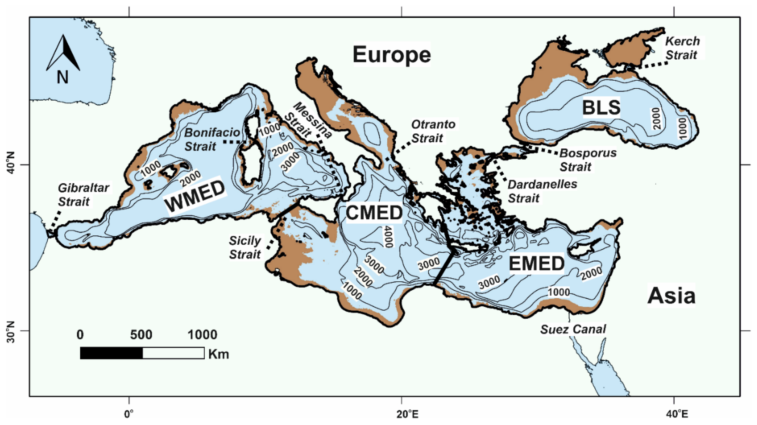
The Mediterranean Sea can be divided into its primary marine regions [19,20], the Western Mediterranean basin (WMED), the Central Mediterranean basin (CMED) and the Eastern Mediterranean basin (EMED), while the Black Sea (BLS) includes only one primary marine region (Figure 1). The sea limits between the WMED and the CMED were determined by the International Hydrographic Office [21], whilst the limit between the CMED and EMED was identified partially by the IOC (i.e., NW promontory of Crete and Greek Mainland), Carter et al. [19] and Jensen et al. [20] (i.e., southwest end of Crete to Libya), as described by Poulos [1]. Moreover, the Marmara Sea, which connects the MED with the BLS, although according to the International Hydrographic Office [21] does not belong to the MED, was considered part of the MED in several environmental studies (e.g., [1,22,23,24,25]).
The MED (including the Sea of Marmara) occupies an elongated, irregular deep depression (Figure 2), with a sea surface area of 2530 × 103 km2 and a water volume of 3.88 × 10⁶ km3 (Table 1). Its average depth is 1544 m, whilst its deepest point is 5267 m. The MED shelf occupies 16.5% of the seafloor, while >40% of it is deeper than 2000 m.
The BLS (Black Sea and the Azov Sea) has a surface area of 463,509 km2 and a volume of 550 × 103 km3 (Table 1). According to EMODnet [26], its maximum depth is 2590 m (or 2245 m according to the encyclopaedia of Ukraine), occurring in the Euxine abyssal plain. The BLS shelf occupies 32% of the seafloor, while >58.5% of it lies at water depths >1000 m [27].

Table 1.
Physiographic characteristics of the Mediterranean Sea (MED) and Black Sea (BLS) (data abstracted from [27]).
Table 1.
Physiographic characteristics of the Mediterranean Sea (MED) and Black Sea (BLS) (data abstracted from [27]).
| GIBR. ST. | MED | MED (excl. MAR) | BLS | |
|---|---|---|---|---|
| Sea surface area (SS in km2) | 1630 | 2,530,148 | 2,518,261 | 463,509 |
| Depth mean/maximum (m) | 365/900 | 1544/5267 | 1539/5267 | 1195/2590 |
| Volume (V in 106 km3) | 0.0006 | 3.88 | 3.87 | 0.55 |
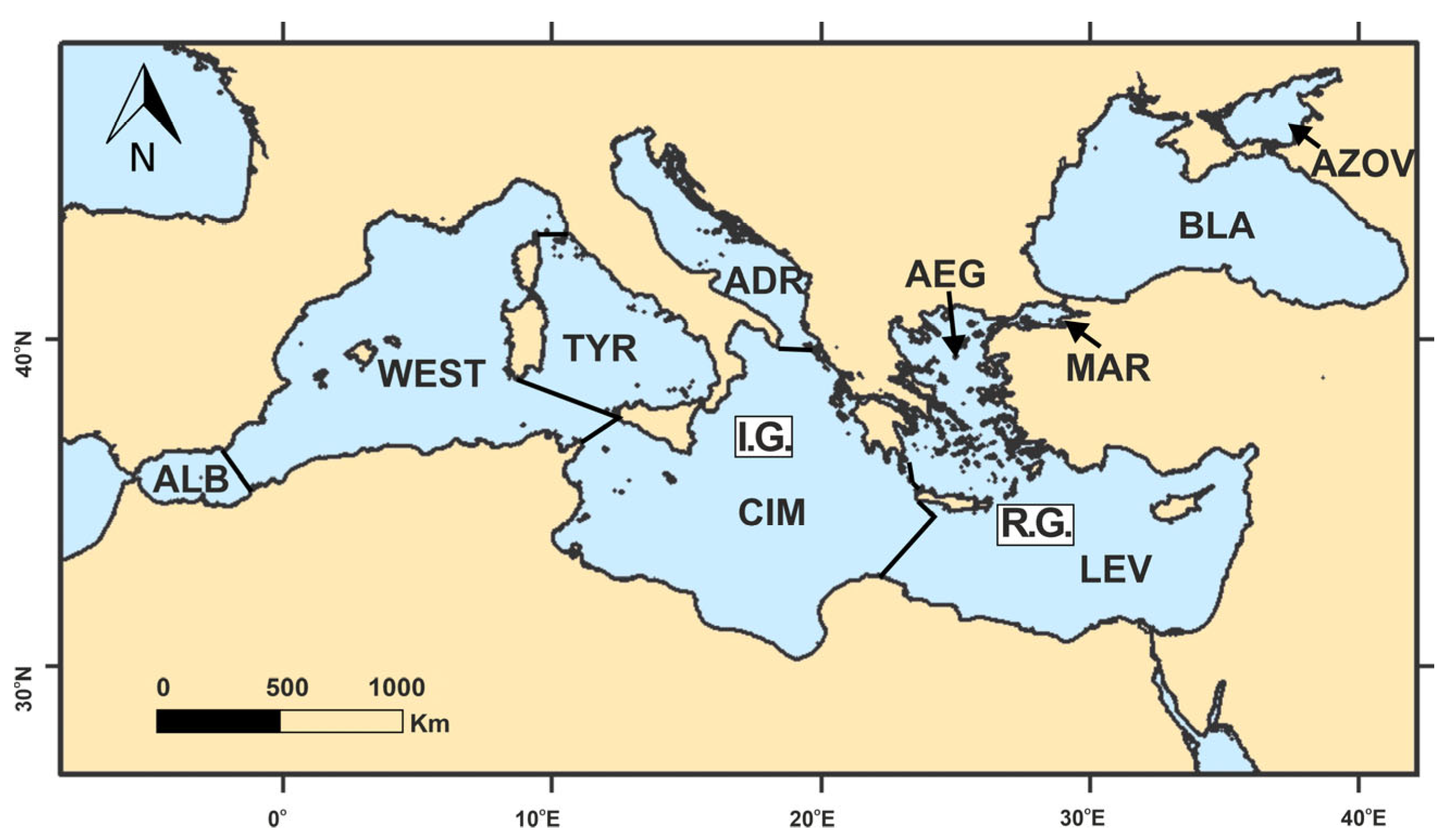
The three primary marine regions of the MED (WMED, CMED and EMED) are subdivided into secondary marine regions, originally by Cruzado in 1985 [28] and subsequently by UNEP/MAP/MED POL [22], Ludwig et al. [24], Woodward [29], Coll et al. [30], UNEP [22] and Poulos [1] (Figure 3). Thus, the WMED includes the Alboran (ALB), West (WEST) and Tyrrhenian (TYR) Seas, the CMED consists of the Adriatic (ADR) and CIN (Central-Ionian) Seas and the EMED encompasses the Levantine (LEV), Aegean (AEG) and Marmara (MAR) Seas (Figure 1). The BLS also includes two distinct marine regions: the Black Sea (BLA) and Azov Sea (AZOV), with their sea limits also being set by IHO [21]. In the Table A1, Table A2, Table A3 and Table A4 in Appendix A, the main physico-geographical characteristics of the secondary marine regions of mentioned above are presented.
3. Water Masses
The water masses of the Mediterranean and Black Sea are examined in relevance to their presence in the three primary marine regions of the Mediterranean (WMED, CMED, EMED), the Black Sea (BLS), and the Strait of Gibraltar through which the water exchange between the Mediterranean and the Atlantic Ocean takes place.
3.1. Strait of Gibraltar
In the straits of Gibraltar there are two oppositely flowing water masses: (i) the upper (surface) water mass of Atlantic origin entering the Mediterranean Sea and (ii) the lower (near seabed) water mass outflowing from the Mediterranean Sea.
Atlantic Water (AW): This water enters the Mediterranean Sea (the Alboran Sea) through the Gibraltar Strait, occupying the upper 100 m of depth (west end of Gibraltar strait) with mean annual ranges of potential temperature θ ≅ 10–16 °C, salinity S ≅ 34.9–36.5 and density σθ ≅ 26.87–26.90 kg/m3 (Argo-floats data from [31]); Bergamasco and Malanotte-Rizzoli [32] have given values of θ = 14–16 °C and S = 36.0–36.5. The inflow of Atlantic Water (AW) has been estimated to range from 0.72 Sv [33] to 1.01 Sv [34] with most calculations on the order of 0.72–0.92 Sv (e.g., [35,36]). The different ranges of the water flux are explained by the different periods and methods of calculations; the latter refers to the Mediterranean water balance, rates of evaporation/precipitation (salt content) and the applied hydrodynamic models simulating the two oppositely flowing water layers. Moreover, regarding ongoing climate change, Fedele et al. [37] found a clear increase in the annual trend in salinity (~0.007 ± 0.140/y) and temperature (0.026 ± 0.715 °C/y) over the last two decades.
Mediterranean Outflow Water (MOW): This water mass flows along the Gibraltar Strait, as a sub-surface water mass, into the Atlantic Ocean at a depth of 800–1000 m having a mean temperature of about 13.1 °C and a salinity of 38.4 (for the years 2005–2014; after García-Lafuente et al. [38]). The MOW is mainly composed of the LIW and WMDW, with minor contributions from other intermediate (e.g., WIW) and deep (TDW) water masses [39]. Estimates of the Mediterranean outflow vary from 0.67 Sv [40] to 0.85 Sv [36], with most of the estimates ranging between 0.76 Sv and 0.82 Sv [38]. Moreover, based on velocity data (2004–2020) from the westernmost Camarinal sill of the Strait of Gibraltar, a discharge value of 0.847 ± 0.129 Sv with a slight decreasing trend of 0.017 ± 0.003 Sv/decade was provided by García-Lafuente et al. [38].
In Table 2, the physical characteristics of the aforementioned water masses are presented.
3.2. Western Mediterranean (WMED)
The hydrological conditions in the marine region of the Western Mediterranean (WMED) are primarily configured by (e.g., [2,3,5]): (a) the influx of Atlantic Water through the Strait of Gibraltar; (b) the influx at intermediate depths of the more saline waters originating from the Eastern Mediterranean (EMED); (c) the formation of intermediate waters within the Provençal and Tyrrhenian basins; (d) the formation of dense water masses primarily along its northwestern continental margin; (e) the sea bed topography (i.e., sills and depressions); and (f) decadal and/or seasonal variability in characteristics induced by climate change and/or variability trends. A brief description of the formation and spatial extent of water masses within the EMED are described below and divided into surface, intermediate, and deep waters.
3.2.1. Surface Waters
The surface water masses observed in the WMED marine regions are represented by Modified Atlantic Water, which is the result of AW transformation during its eastward movement.
Modified Atlantic Water (MAW): Atlantic Water (AW) moving eastwards is progressively modified due to air-sea interaction (i.e., evaporation) and by mixing with underline waters, thus becoming saltier and warmer. In this context, temperature (14.01–15.08 °C) and salinity (37.26–37.79) in eastern ALB M.R. [41] reach temperature and salinity values at the Sicily Strait equal to θ = 16.1 °C and S = 38.72–38.81 ([42], for 1995–2000). Moreover, this increase in salt content makes MAW denser, with the salinity core progressively sinking to greater water depths; the latter process also reduces air-sea interaction processes [37]. Therefore, MAW is present in the three marine regions of the EMED (i.e., ALB, WEST and TYR), with slightly different values of temperature and salinity (Table 3).
3.2.2. Intermediate Water Masses
The intermediate water masses include the Levantine Intermediate Water (LIW) originating from the EMED M.R, the Western Intermediate Water (WIW) (formerly Winter Intermediate Water) that is formed within the WEST M.R., and the Tyrrhenian Intermediate Water (TIW) formed within the TYR M.R.
Levantine Intermediate Water (LIW): Levantine Intermediate Water is formed in the homonymous basin of the EMED M.R., after which it enters the WMED M.R. through the Strait of Sicily-Tunisia at water depths of 100–200 m, having θ < 13.8 °C and S = 7.9–38.2 [42]. In the WEST M.R., the core of the LIW has been detected at water depths of 200–600 m, having general temperatures of (13.0–14.2 °C), salinity of (38.4–38.8) and density of (29.0–29.10 kg/m3) (e.g., [43,44,45]). The properties of the LIW differ among the WEST, TYR and ALB marine regions due to mixing processes taking place during its westward transportation. Thus, the LIW, with θ = 14.07 and S = 38.85 in the WEST M.R. [46], in the eastern part of the ALB M.R. attains values of θ = 13.23 and S = 38.5 [47], while after both regions’ entrance into the TYR M.R., their respective ranges are θ = 14.0–14.6 °C and S = 38.5–38.8 ([48]: ARGO Floats 2004–2017).
Western Intermediate Water (WIW): This water mass is observed below the ΜAW and above the LIW (e.g., [3,49]). It is produced under cold winter conditions in the Gulf of Lions, in the Catalan basin [50] in the Ligurian Sea [51], and at lower latitudes along the Spanish continental shelf (down to Cape Palos) [41]. Its potential temperature and salinity values are on the order of θ = 11.5–13.0 °C and S = 37.7–38.3, respectively [41]. In addition, from 2011 to 2015, Juza et al. [52] identified an increasing trend in temperature and salinity on the order of θ = 0.07–0.15 °C/y and S = 0.003–0.040/y, respectively. The WIW, having similar characteristics to TIW (as shown in the next paragraph) and being also formed by winter convection within the Tyrrhenian basin [48], could not be identified in TYR M.R. On the other hand, WIW was identified in the ALB, having maximum values of θ = 13.1–13.2 °C (at water depths of 200–400 m) and S = 38.50–38.52 at water depths of 300–500 m [53].
Tyrrhenian Intermediate Water (TIW): Tyrrhenian Intermediate Water is also produced by winter convection within the TYR, as in the case of WIW, and more specifically in its central part, where the presence of the Bonifacio dipole of circulation mixing induces a homogenization of the water column down to a depth of about 400 m (e.g., [54,55,56]). TIW is placed in between the MAW and the LIW waters at depths of 100–200 m. Although the TIW presents some differences in temperature and salinity between its northern and southern sectors, its temperature and salinity range on the order of 13.9–14.4 °C and 38.1–38.3, respectively (Argo floats 2004–2017; after Iacono et al. [48]). Moreover, the outflow of TIW in the Algero-Provensal basin (WEST M.R.) is known to have a strong influence on the hydrology and circulation of the WEST marine region (e.g., [57]); although the maximum values of the TIW outflow during winter can exceed 1.5 Sv, during summer, they remain very low [58].
3.2.3. Deep Waters
The major deep water masses in the WMED M.R. are: (i) the Western Mediterranean Deep Water (WMDW) and (ii) the Tyrrhenian Deep Water (TDW) within the TYR M.R.
Western Mediterranean Deep Water (WMDW): These waters, as said earlier, are one of the principal water masses of the western Mediterranean Sea that fill its deeper part (>1000–1200 m), having an average potential temperature of 12.5–14.5 °C and a salinity of S = 37.7–38.6 [59]. WMDW is mainly formed within the cyclonic gyre of the Gulf of Lions by open sea convection; the latter is associated with the presence of strong northerly winds (Mistral), which induce excessive heat loss reaching 1000 W/m2. The diameter of the cyclonic gyre typically ranges from a few 10ths of km to 100 km, while it can extend vertically down to the sea bottom (~2400 m depth). The newly formed water has a typical σθ of about 29.10 kg/m3, while its formation rate is estimated to be about 0.3 Sv [60]. In addition, dense waters (formed over the continental shelf) flow as a strong near-bed gravity current along the continental slope to a depth with surrounding waters of similar density. The volume of produced dense waters differs substantially from year to year. For example, during the very harsh winters of 2004–2005 and 2005–2006, large volumes of warmer (θ = 12.85–12.88 °C), saltier (S = 38.45–38.47) and thus denser (σθ = 29.10–29.12 kg/m3) waters were formed in the Gulf of Lions and, being denser than the pre-existing WMDW, reached the seafloor [6]; the latter process caused an extensive renewal of the WMDW between 2004 and 2006. These major events in the mid 2000’s have been associated with the Western Mediterranean Transient (WMT) [61,62,63]; the latter was the result of the hydrological changes related to the Eastern Mediterranean Transient (EMT) (e.g., [61,62,63]). During this event, saltier and warmer intermediate waters inflowed through the Sicily Strait [64]. This was a consequence of dense water formation in the Aegean Sea from 1988 to 1995 that had led to the most significant intermediate-to-deep water overturning perturbation in the EMED [65]. The seawater properties (θ, S) of deep waters (WMDW) present pretty similar values in the WEST and ALB (Table 3), while in the case of TYR, they are represented by the Tyrrhenian Deep Water (see below).
Tyrrhenian Deep Water (TDW): This water is present above the WMDW [66], having slightly higher temperature (about 0.2 °C) and salinity (about 0.03) than that of the WMDW, when generally TDW has temperature and salinity on the order of 12.75–12.85 °C and 38.42–38.46, respectively [67]. This local water mass is produced from the mixing of: (a) waters of eastern origin inflowing through the Sicily Strait and probably being related to EMT; (b) waters of western origin, inflowing through the Sardinia Channel; and (c) resident (pre-existing) deep waters [49]. However, Fuda et al. [68] have argued that TDW might be the result of a dense water formation process taking place to the east of the Bonifacio Strait. TDW is exported into the western part of the WEST through the Sardinia Channel, wherein is mixed with the WMDW [53]. On the basis of hydrographic data collected during Nov./2006, Feb./2007, Apr./2007, June/2007, Feb./2008 and Jan./2009, the water column of the TYR between 600 m and 2500 m exhibited an increasing trend in temperature and salinity at a mean rate of θ = 0.025 °C/y and S = 0.0075/y, respectively, compared to the findings in earlier studies. This change has been associated with and is most likely due to the downward transfer of excess heat and salt from intermediate water depths [69].
In Table 3, the physical characteristics of the aforementioned water masses are presented for the different marine (secondary) regions of the EMED.
Table 3.
Temperature (θ, potential), salinity (S), practical density (σθ, for potential temperature) and the depth of the water masses (W.M.) existing in the Western Mediterranean (WMED).
Table 3.
Temperature (θ, potential), salinity (S), practical density (σθ, for potential temperature) and the depth of the water masses (W.M.) existing in the Western Mediterranean (WMED).
| W.M. | θ (°C) | S | σθ (kg/m3) | Depth (m) | Ref. |
|---|---|---|---|---|---|
| Alboran M.R. | |||||
| MAW | >15.0 14.01 ± 0.33–15.08 ± 0.47 | 36.60 37.26 ± 0.24–37.79 ± 0.22 | <27.425 | 0–150/200 | [47] [70] |
| WIW | 13.30 ± 0.12 | 38.23 ± 0.10 | [70] | ||
| LIW | 13.23 13.13 ± 0.02 | 38.50 38.49 ± 0.01 | 29.06 | 200–600 | [47] [70] |
| WMDW | 12.90 12.97± 0.01 | 38.48 38.48 ± 0.04 | 28.74 | >600 | [47] [70] |
| West M.R. | |||||
| MAW | 16.16 | 36.61 | 26.95 | 0–50 | [46] |
| WIW | 11.5–13.0 | 37.7–38.3 | 28.78–28.72 | 100–300 | [70] |
| LIW | 14.07 | 38.85 | ≈29.15 | 300–600 | [46] |
| WMDW | 12.5–14.5 | 37.8–38.6 | >1000 1480 | [59] [46] [68] | |
| 12.86 | 38.46 | ||||
| 12.70–12.75 | 38.40–38.44 | 20.09–29.11 | |||
| Tyrrhenian M.R. | |||||
| MAW | 15.0–18.0 | 36.2–38.2 | 26.74–27.72 | 0–150 | [48] |
| TIW | 13.9–14.4 | 38.1–38.20 | 100/150–200/300 | [48] | |
| LIW | 14.1–14.7 | 38.4–38.8 | 28.82–28.97 | 200–700 | [48] |
| TDW | 12.75–12.85 13.3–13.8 | 38.42–38.46 38.45–38.8 | 700–1500 | [67] [48] | |
3.3. Central Mediterranean (CMED)
The water masses that make up the hydrography of the central part of the Mediterranean Sea are mainly distinguished, due to seafloor relief, into those attributed to the shallow Adriatic marine region (ADR) and those present in the deep Central-Ionian (CIM) marine region.
3.3.1. Surface Waters
Surface waters in CMED include: (i) the Modified Atlantic Water (MAW) inflowing from the WMED through the Sicily Strait; (ii) the Surface Ionian Water (SIW) occupying the CIM M.R.; and (iii) the surface water mass of the ADR (AdSW: Adriatic Surface Water).
Modified Atlantic Water (MAW): The relatively fresher (S = 36.8–37.5) and colder (13.85–15.0 °C) Modified Atlantic Water (MAW) enters the CMED M.R. via the Sicily Strait (e.g., [42,71]) and thence, a branch of the MAW moves northwards towards the ADR M.R., occupying the northern part of the CIM. Another branch moves eastwards towards the south Cretan Passage.
This circulation pattern of MAW is also related to the presence of the Ionian Gyre, whose direction changes occasionally. Thus, during the EMT (approximately from 1987 to 1997), a transition from a cyclonic to an anticyclonic circulation pattern took place in the CIM (e.g., [72,73]). During this period, the northward movement towards the Southern Adriatic of the MAW was enhanced whilst at the same time the eastward flow towards the Cretan Passage weakened (e.g., [74,75]). After 1997, when again a cyclonic circulation was established ([73,76,77]), the northward flow of MAW weakened, inducing both salinization of the northern CIM marine region and an enhancement of its eastward transport. Interestingly, a third reversal from the cyclonic to anticyclonic mode took place in 2006, as shown by altimeter data analysis [78].
In the CIM M.R., generally, MAW temperatures (potential) vary between 15 °C and 17 °C, while salinities are <38.6 [71]. Moreover, seasonal atmospheric changes (i.e., exchange of heat fluxes) make the physical properties of the MAW vary substantially; for example, in July/2004, May/2005 and Oct./2005, temperatures and salinities varied in the range of T = 15–20 °C and S = 38.40–38.73 [79].
Ionian Surface Water (ISW): This water mass occupies the north-east sector of the CIM M.R., being the result of mixing between the Levantine Surface Water (LSW) inflowing through the Cretan Straits, the MAW entering through the Sicily strait, and the colder and fresher Adriatic Surface Water (AdSW) that enters through the Otranto Strait [72]. Apart from mixing processes, ISW is subjected also to seasonal atmospheric changes (i.e., exchange of heat fluxes) that are associated with a relatively wide range of temperature (18–23 °C) and salinity (38.77–38.93) as found during cruises in July/2004, May/2005 and Oct./2005 [79].
Adriatic Surface Water (AdSW): The formation of the AdSW is associated with: (a) large amounts of freshwater (riverine) inputs [80] along with groundwater influxes [81]; (b) the advected ISW through the Otranto straits and its subsequent mixing with the previously mentioned water masses; and (c) surface heat loss (some 19–22 W/m2/y [82]) that leads to a seasonally unbalanced content of salt and heat. According to Ruso and Artegianni [83] and for the period 1947–1983, the winter temperatures of surface waters vary from <11.5 °C (Northern Adriatic) to 11.5–13.5 °C (Middle Adriatic) and >13.5% (South Adriatic), while salinity values are <38.0 in the North Adriatic, 38.0–38.5 in the Middle Adriatic and 38.3–38.6 in the South Adriatic. The above trends of temperature and salinity are attributed to the reduced influence of the freshwater inputs in the Southern Adriatic and the advection of more saline waters through the Otranto Strait.
3.3.2. Intermediate Waters
The main water masses in the CIM M.R. present at intermediate water depths are: (i) the Levantine Intermediate Water (LIW); (ii) the Cretan Intermediate Water (CIW) formed in the Cretan basin; and (iii) the Transitional Mediterranean Water (TMW).
Levantine Intermediate Water (LIW): Levantine Intermediate Water is formed in the homonymous sea of the EMED M.R. and enters the CIM M.R. mainly through the Southern Cretan Passage (Crete-Libya) at water depths greater than 200–300 m. Moreover, the presence of LIW in deeper waters, compared to those in LEV, is explained by its increased density obtained during its westward transport; this decrease in temperature is compensated by the parallel decrease in salinity. LIW attain values of θ = 14–15 °C, S ≥ 8.8 and σθ = 29–29.1 [71]. After LIW enters the ADR M.R., mainly through the eastern part of the Otranto Strait, it flows toward the North Adriatic Sea along its eastern coastline [84], having θ = 13.5 °C and S = 38.5–23.86 [85]. LIW water masses are observed mainly in the Middle and Southern Adriatic, while after mixing with the fresher and colder AdSW, they outflow into the CIM M.R, being traced at water depths of about 400 m in the eastern Ionian Sea [86,87].
Cretan Intermediate Water (CIW): In the CIM M.R. above the LIW and below the surface waters (under the pycnocline) lies the mass of CIW. It is justified by a salinity maximum, which is located between 150 m and 300 m. The CIW inflow from the Cretan Sea (South Aegean) where it is formed has θ = 14.8–15.3 °C, S = 38.9 and is slightly less dense (σθ ≤ 29 kg/m3) than the underlying LIW [88].
Transitional Mediterranean Water (TMW): In addition to the aforementioned water masses in the CIM M.R., in between the LIW and the EMDW and at water depths from 400 m to 600 m (or even 800 m) there is the mass of TMW with θ = 13.75–14 °C and S = 38.71–38.80 (July/2004, May/2005 and Oct./2005, after Budillon et al. [79]). The TMW is formed by the mixing of the basin’s deeper intermediate water masses and the upper layer of the deep water masses (i.e., EMDW). The occurrence of TMW is also associated with EMT periods, during which about 20% of the pre-existing EMDW (mostly of Adriatic origin) is replaced by dense waters that originate from the Aegean (Cretan) Sea [54].
3.3.3. Deep Waters
The deep water masses of CMED M.R., as in the case of surface and intermediate water masses, are differentiated to those located in (a) the ADR M.R. and (b) the CIM. Deep waters in ADR M.R. are represented by the Adriatic Deep Water (ADW) while those in CIM M.R. include the masses of the Cretan Deep Water (CDW) that is advected from the Cretan Sea, and the Eastern Mediterranean Deep Water (EMDW).
Adriatic Deep Water (ADW): This water mass is very important as it represents the main source of the dense waters comprising the Eastern Mediterranean bottom waters (EMBWs) (e.g., [89,90,91]). A certain amount of the Adriatic bottom waters formed in the northern sub-basin of ADR, i.e., the NAdDW (North Adriatic Deep Water), have low temperature (about 11.35 °C), relatively low salinity (38.3) and high density (σθ > 29.2). The formation of NAdDW starts in December with the preconditioning phase consisting of: (i) riverine freshwater flux, (ii) heat flux exchanges and (iii) the advection of saline waters from the middle and southern Adriatic Sea (e.g., [92,93,94,95,96]). During January and February, when the northeastern bora wind blows over the Northern Adriatic causing strong evaporation and cooling within a few days, the already homogenised water column to a depth of about 30 m continues to lose heat, forming a certain quantity of NAdDW [97]. The characteristics of the newly formed NAdDW vary significantly from year to year according to the meteorological and oceanographic conditions prevailing during the winter period. In addition, dense waters are present in the Middle (Central) Adriatic all the year at the bottom of the Pomo Pits (about 270 m deep) below the depth of the Pelagosa Sill (about 170 m depth), which separates the Pomo Pits from the north Adriatic, having slightly higher temperature (11.62 °C) and salinity (38.47) than those of the North Aegean. An amount of the waters of Adriatic origin are advected to the mid-Adriatic, flowing along the western side of the ADR M.R. They subsequently invade the Pomo Pits in spring, renewing the pre-existed MAdDW. However, most of the Adriatic bottom waters (about 82% according to Mantziafou and Lascaratos [98]) formed in the southern Adriatic sub-basin ([85,90,99]) and are named South Adriatic Deep Water (SAdDW); it is warmer (θ = 13.61 °C) and saltier (S = 38.61) than the NAdDW and MAdDW. The formation processes of SAdDW are quite different compared to those of the NAdDW. SAdDW is formed in the winter through open ocean convection, inside the south Adriatic Pit (depths > 1200 m)—to the south of the Palagruza sill (depths < 200 m)—where a cyclonic gyre is nearly permanently present, and mixing subsequently with LIW. The outflow of the dense Adriatic waters through the western part of the Otranto Strait [100] are on the order of about 0.3 Sv [90]. The amount of outflowing ADW might be enhanced during dense-water-productive years (e.g., 0.33 Sv in 1975/76) or lowered during dense-water-non-generative years (e.g., 0.14 Sv over the 1976–1980 interval after [87]).
Cretan Deep Water (CDW): It forms within the Cretan basin via processes of deep-water formation (see Section 3.4.1.3) and enters the CIM M.R. via the southwest Aegean passage (Crete-Antikythira-Kythira-Peloponnese) mainly during periods of manifestation of EMT. The physical characteristics of the CDW in the CIM M.R. during the cruises of 7/2004, 5/2005 and 10/2005 were θ = 13.2–13.6 °C and S = 38.70–38.77 [79].
East Mediterranean Deep Water (EMDW): It is present below the CDW (water depths > 1200 m), characterised by a mean temperature of 13.2–13.6 °C and salinity of 38.70–38.77 in July/2004, May/2005 and Oct./2005 [79]. The largest part of the EMDW forms after mixing with the denser (about 29.24 kg/m3) ADW, whose temperature and salinity during the above-mentioned cruises was θ = 13.5–13.7 °C and S = 38.66–38.76. The EMDW is also the result of a mixture between pre-existing water masses (old-EMDW) and the inflowing water mass from the ADR (ADW) and from the Cretan Sea (CDW) [72].
In Table 4, the physical characteristics of the aforementioned water masses are presented for the different marine (secondary) regions of the CMED M.R.
3.4. Eastern Mediterranean (EMED)
The water masses of the EMED present pronounced differences between the three secondary marine regions (LEV, AEG and MAR) due to complex oceanographic processes and their irregular seabed morphology. For this reason, the surface, intermediate and deep water masses are presented separately for each marine region.
3.4.1. Levantine M.R.
The LEV marine region from the oceanographic point of view can be distinguished in the main Levantine basin to the east of 26.5 °E longitude and the south Cretan Passage, i.e., the marine area located between the south coast of Crete Island and the African coast. The LEV M.R. includes: (i) the surface water masses represented by the Levantine Surface Water (LSW) and Modified Atlantic Water (MAW); (ii) the intermediate water masses represented by the Levantine Intermediate Water (LIW) and the Transitional Mediterranean Water (ΤΜW); and (iii) the deep water masses represented by the Cretan Deep Water (CDW) and the East Mediterranean Deep Water (EMDW).
3.4.1.1. Surface Waters
There are two main water masses in the LEV M.R.: (i) Modified Atlantic Water (MAW) and (ii) Surface Levantine Water (LSW).
Modified Atlantic Water (MAW): It enters the LEV through the southern Cretan passage, occupying mainly the western part of the LEV, i.e., in between Crete Isl. and the African coast. MAW extends to water depths up to 100 m with S ≤ 38.89 and variable temperatures on an annual and seasonal basis. For example, in April 2016, the MAW at approximately 50 m of water depth had θ = 17–23 °C and S ≤ 38.9 [101], when the average temperature during summer in the central part of the Levantine basin was 18.22 ± 1.39 °C. Moreover, Ozer et al. [102] for the period 1979–2014 identified in the Levantine basin an increasing trend of temperature and salinity, with rates on the order of T = 0.12 ± 0.07 °C/y and S = 0.008 ± 0.006/y.
Surface Levantine Water (LSW): MAW flowing eastwards undergoes continuous transformation due to evaporation, heating, and eddy formation-decay [103], resulting in the formation of the highly saline (≥39.0) LSW with temperatures > 17 °C [104]. It occupies most of the main Levantine basin (to the east of Crete), extending to water depths of between ca. 50 m (in summer) and ca. 100 m in winter (e.g., [103,105]. Temperatures vary considerably on a seasonal basis, obtaining values of 16.2 ± 0.4 °C (in winter), 19.16 ± 0.34 °C (in spring) and 24.05 ± 2.3 °C (in summer) according to Ozsoy et al. [105]. Moreover, temperature and salinity show a slight increasing trend from 1979 to 2014, with annual rates on the order of θ = 0.04 ± 0.05 °C/y and S = 0.005 ± 0.006/y [102].
3.4.1.2. Intermediate Waters
The intermediate waters in EMED include: (i) the Levantine Intermediate Water (LIW), which is a principal water mass, not only for the EMED but for the entire Mediterranean Sea; and (ii) the Transitional Mediterranean Water (TMW) in association with the periods of EMT.
Levantine Intermediate Water (LIW): It is formed when the saline LSW, due to intense evaporation during summer, cools down during winter from the dry northerly winds and sinks to intermediate depths from ca. 130 m to 350 ± 50 m ([43,104,105]); this process usually takes place as LSW reaches the Rhodes Gyre [106]. Moreover, the formation of LIW may also occur along the continental margins of the Levantine basin [105]. The typical values of salinity are on the order of 38.74–39.20 and those of temperature (potential) of 15–17 °C ([43,60]). More recently, during the cruises in April /2016 and July/2016, the LIW core (found at approximately 125 ± 40 m) had θ = 16.20 ± 0.6 °C and S = 39.09 ± 0.05 [101]. Moreover, temperatures and salinities show an increasing trend between 1979 and 2014, with mean annual rates on the order of θ = 0.03 ± 0.02 °C and S = 0.005 ± 0.003 [102].
Transitional Mediterranean Water (TMW): It is present at water depths of 600–1200 m [101] with a mean potential temperature of about 13.6 °C and salinity of 38.74–38.76; these values (θ, S) correspond to a potential density (σθ) of 29.17–29.19 kg/m3 [105]. Additionally, Vervatis et al. [107] during the winter surveys of 2005 and 2006 identified the core of TMW at a depth of 750 m to have θ = 14.2 °C, S = 38.92 and σθ = 29.18 kg/m3. The formation of TMW is analogous to that described in the case of the CIM M.R., i.e., the mixing of LIW with the basin’s deep water masses (EMDW and CDW) during periods of dense water formation in the AEG and outflowing to the LEV during periods of East Mediterranean Transient.
3.4.1.3. Deep Waters
The deep water masses in LEV are represented by: (i) the East Mediterranean Deep Water (EMDW), formed locally; and (ii) the Cretan Deep Water (CDW), advected from the Cretan Basin.
East Mediterranean Deep Water (EMDW): The dense waters filling the basinal depths (>2500 m) in the LEV M.R. are similar to those discussed earlier in the case of the CIM M.R. Prior to 1990, it was believed that the main source of the dense deep waters of the EMED was the ADR, presenting annual fluxes through the Otranto Strait on the order of 0.3 Sv. Although this process has an annual recurrence, in the early 1990s, dense waters were observed outflowing from the Cretan Straits (e.g., [61,108]). Because of its transient nature, this process has been called the Eastern Mediterranean Transient (EMT). More specifically, the EMT refers to a change in the deep water source of the EMED from the Adriatic Basin to the Aegean Basin, causing the presence of warmer, saltier deep and intermediate water masses in the eastern Mediterranean; this change is also transmitted to the WMED through the Sicily Strait [109]. Although there is not a consistent and quantified theory of the cause of the EMT, the following processes have been proposed [110]: (a) internal redistribution of salt [108], (b) changes in the local atmospheric forcing (e.g., increased evaporation) over the Aegean combined with long-term salinity change (e.g., [106,111]); (c) variations in fresh Black Sea water influx [112]; and (d) changes in circulation patterns leading to changes either in the influx of LIW and/or of the Modified Atlantic Water (MAW) ([71,113]). Furthermore, during the peak EMT period (between mid-1992 and late 1994), Roether et al. [114] estimated that the mean outflow of CDW through the Cretan Arc Straits accounted for ca. 2.8 Sv; this value is an order of magnitude larger than the typical ADW formation rate. Therefore, by 1995, it was estimated that about 20% of EMDW was replaced by this new denser water mass [106]. In general, the temperature and salinity that characterise the EMDW are θ = 13.6 °C and S = 38.7 [76,88]. More recently, south of Crete and at water depths >3000 m, potential temperatures varied from 13.44 °C to13.51 °C, salinity was 38.74 ± 0.01 and density was 29.194 ± 0.002 [113].
Cretan Deep Water (CDW): It is formed within the Cretan Sea and was first observed in 1998 by Theocharis et al. [101]. Tsimplis et al. [115] used a simple hydraulic model to estimate the deep-water fluxes of Cretan Deep Water (CDW) through the Cretan Arc Straits and into the Eastern Mediterranean Basin. The results show a significant CDW outflow of 0.75 Sv in early 1995. Thereafter, CDW has been reported repeatedly (e.g., [86,114,116,117]). The formation of CDW has been attributed to the onset of EMT of 1988–1990, when lower-than-climatic-average atmospheric temperatures prevailed in the Aegean Sea [106] that, combined with the saltier LSW, produced dense waters in the central and southern Aegean, which submerged to depths > 600 m within Cretan basin. Subsequently, these dense waters outflow from the Cretan Straits during the EMT relaxation periods (1996–2000). The core values of old CDW identified in LEV found at water depths of 1400–2500 m were θ = 13.58 ± 0.02 °C, S = 38.76 ± 0.01, and σθ = 29.188 ± 0.004 kg/m3 [101].
3.4.2. Aegean M.R.
The Aegean Sea M.R. presents the largest number of water masses due to: (a) a very irregular morphology of the seabed with a clear separation between its northern (maximum depth 1500 m) and southern sector (maximum depth 2800 m) by the Cyclades plateau (maximum depth about 400 m) located in between them; (b) its water balance, related to air-sea heat flux exchanges, river inputs and the exchange of water masses with the adjacent marine regions (i.e., the Black Sea and the Levantine Sea); and (c) its seasonality of climatic conditions (e.g., [2,71,104,112,118]). The description of the surface, intermediate, and deep water masses of the AEG M.R. follows.
3.4.2.1. Surface Waters
The surface waters, having a rather distinctive spatial presence, include: (i) the low-salinity Black Sea Water (BSW) mostly in the North Aegean Sea; (ii) the high-salinity Levantine Surface Water (LSW) in the southeastern Aegean; (iii) the Modified Atlantic Water (MAW) primarily in the south Aegean; and (iv) the Cretan Surface Water (CSW) in the central and eastern part of the south Aegean Sea (Cretan Sea).
Black Sea Water (BSW): This water mass dominates the surface waters up to a depth of 40–50 m in the northern Aegean Sea, having generally temperatures > 14 °C and salinities 30–36 [119]. The influx of BSW accounts for approximately 1200 km3/y [120]. BSW flows westward and then southwards along the east coast of the Greek mainland, whilst a branch of it flows towards the Cyclades plateau [121]. BSW can be also traced in the Cretan Sea, where in April 2016 it had θ = 15.9–17.0 °C and S = 38.87–39.01 [122].
Modified Atlantic Water (MAW): This water mass has been traced along the western part of the Cretan Sea and to the east of the Cyclades plateau [101]. It enters the South Aegean (Cretan Sea) primarily through the western and secondarily through the eastern Cretan Straits at depths < 100 m. As it presents similar characteristics to those of the BSW, their differentiation becomes rather difficult. In the Cretan Sea, in June 2016, MAW extending to water depths up to 50 m with T = 17–23 °C and S ≤ 38.9 was found [101].
Levantine Surface Water (LSW): Levantine Surface Water is observed primarily in the eastern part of the South Aegean, advected through the eastern Cretan passage from the LEV M.R., extending to water depths < 100 m, with θ > 18 °C and S = 39.1–39.3 [122].
Cretan Surface Water (CSW): Cretan Surface Water occupies the central and western part of the South Aegean (Cretan Sea), being relatively cooler (>18.0 °C) and less saline (39.0–39.1) than the above-mentioned LSW [101]. Its formation involves the mixing of: (a) the MAW entering from the western Cretan strait, (b) the influx of the modified BSW, and (c) the westward-flowing LSW after its entry in the southeast Aegean Sea (as mentioned earlier).
3.4.2.2. Intermediate Waters
The intermediate water masses of the AEG M.R. include: (i) the LIW, advected from the LEV M.R.; (ii) the AgIW (Aegean Intermediate Water), produced after the mixing of BSW and LIW; (iii) the Cretan Intermediate Water (CIW), produced in the Cretan Sea; and (iv) the Transformed Mediterranean Water (TMW) mostly observed in the Cretan Sea in association with EMT events.
Levantine Intermediate Water (LIW): The LIW, advected from the LEV M.R. primarily through the east Cretan Straits [104] and secondarily (occasionally) through the west Cretan Straits [55], is characterised by high salinities (≥38.89) and potential temperatures > 14.3 (winter) [104]. During the cruises in April and June of 2016, LIW was found to have S = 39.11–39.14 and θ = 16.2–16.7 °C [101]. LIW flows northwards along the Turkish coast reaching the Limnos plateau, where it is mixed with the colder and fresher BSW, producing the AgIW (or MLIW: Modified Levantine Intermediate Water), eventually reaching the entrance of the Dardanelles Strait.
Cretan Intermediate Water (CIW): Cretan Intermediate Water is formed in the Cretan Sea during winter convection episodes and is observed at water depths of 200–300 m ([123,124]). CIW presents interannual variability, appearing in some cases colder, more saline, and denser than LIW (e.g., [55,104]). Thus, in June of 2016, CIW was detected at water depths of 200–400 m, having θ = 15.5–15.7 °C and S = 39.05–39.07 [101]. The differentiation between LIW and CIW becomes rather easier after CIW leaves the Cretan Sea towards the EMED, where it settles at depths slightly deeper than LIW due to its slightly higher density. Subsequently, CIW moves westwards along the Cretan continental slope towards the Ionian Sea (CIM M.R.) as mentioned earlier (e.g., [86,111,125]).
Aegean Intermediate Water (AgIW): Aegean Intermediate Water was first recognized during the R/V Yakov Gakkeln Cruises (22 Feb.–25 Apr. of 1988 and 24 Jan.–4 Mar. of 1990) as a colder water mass than LIW, being formed locally during the transformation and mixing of BSW and LSW [121]. In addition, Velaoras and Lascaratos [126] analysing CTD data covering a period between 1993 and 2001 also identified an intermediate water mass produced during winter in the North and Central Aegean Sea; they named it “Modified Levantine Intermediate Water (MLIW)” in order to denote its difference as being colder and denser than the LIW. In addition, to differentiate AgIW from the BSW, the LSW and the underlying waters, an isohaline surface of 38.7, isotherm surface of 14.7 °C and isopycnal surface of 29.2 kg/m3 are used. The bulk of AgIW is found at water depths of 140–370 m, while during 1988 it was observed by Gertman et al. [121] at water depths of 240–430 m. Velaoras [101] in April/2016 identified AgIW at water depths between 140 m and 430 m having θ = 14.39–14.43 °C and S = 38.93–38.95, while Vervatis et al. [107] in the Southern Aegean Sea reported values of θ = 13.9–14.4 °C and S = 38.7–39.0 at water depths of 100–350 m.
Transitional Mediterranean Water (TMW): At depths greater than 350–400 m down to 600–700 m, a relatively cooler and, therefore, slightly denser TMW is present; its formation is associated with the occurrence of EMT, representing an older water mass in the EMED (e.g., [124,127]). TMW appears recurrently in the Cretan Sea as a compensation of the outflow of the dense water mass to the EMED. During the post-EMT period, TMW was characterised by θ = 14.2 °C and S = 38.92, having its core ca. 750 m (Mar./2005 and Feb./2006), according to Vervatis et al. [107]. Additionally, during the spring of 2016, TMW was identified at water depths of 600–800 m, having θ = 13.90–14.15 °C and S = 38.85–38.94 [101].
3.4.2.3. Deep Water Masses
There are three deep water masses that fill the deepest parts of the Aegean Sea: (i) the North Aegean Deep Water (NAgDW); (ii) the Central Aegean Deep Water (CAgDW); and (iii) the Cretan Deep Water (CDW). It should also be noted that in some publications, NAgDW and CAgDW have been considered as one water mass under the name NAgDW. According to this approach, all the deep waters, filling the various sub-basins located to the east and north of the Cyclades plateau (depths < 400 m), are considered to be part of the North Aegean. Therefore, the deep sub-basins to the south of the Aegean volcanic arc (i.e., Myrtoon, Cretan, Karpathos) belong to the Southern Aegean. The deep (>1000 m) water masses of the South Aegean fall under the name of Cretan Deep Water (CDW) as they exhibit quite similar, if not identical, characteristics.
North Aegean Deep Water (NAgDW): In the North Aegean Sea, the NAgDW is found in depressions 700–1300 m separated by sills (200–500 m) that impede water exchanges between them, as in the case of the Athos and Sporades depressions. According to Theocharis and Georgopoulos [128], prior to EMT the NAgDW had θ = 13.2–13.3 °C, S = 38.80–38.85 and σθ = 29.27–29.32. Especially during the winter of 1988, the main volume of NAgDW was observed at water depths of ca. 740 m having θ = 12.72–12.78 °C and S = 38.76–38.82 [121].
Central Aegean Deep Water (CAgDW): Deep water masses in the Central Aegean fill the isolated depressions (i.e., the depressions of North Skyros, Chios and North Ikaria), which extend to depths between 500 m and 1000 m. In general, deep water masses in the Central Aegean Sean are characterised by S ≥ 38.7 and θ = 13.2–13.9 °C, while for their separation from the overlying AgIW, the isopycnal surface of 29.20 kg/m3 was used by Gertman et al. [121]. In addition, during the late winters of 1988 and 1990, the CAgDW was warmer and saltier than the NAgDW, but with slightly different values of temperature and salinity of the waters filling the different depressions (depths >500 m). Thus, the deep water mass in the North Skyros depression was colder (13.38–13.44 °C) and saltier (38.94–39.06) compared to that of the Chios and North Ikaria depression (θ = 13.44–13.50 °C; S = 38.82–38.88). This difference has been attributed to the dense waters that formed on the Lesvos-Lemnos plateau [112] and filled the adjacent North Skyros Depression. Based on ARGO float data (2010–2017), CAgDW at 800 m water depth was found to have θ = 14.2, S = 39.0 and σθ = 29.22 [129].
Cretan Deep Water (CDW): This water mass is characterised by θ ≥ 13.9 °C and S ≥ 39.95 and is differentiated from overlying intermediate waters by an isopycnal surface of 29.20 (e.g., [121,127]). Similar values have been given by Kassis and Kores [129], who analysed ARGO float data spanning from 2010 to 2017. The main source of this water mass is the inflowing dense waters formed on the Cyclades Plateau. The latter process that was enhanced during the EMT could cause a slight, although crucial, increase in salinity and, therefore, in density of the CDW. For example, after the cold winter of 1987, water densities below 1000 m began to increase above 29.2 kg/m3, leading to the uplifting of the isopycnal of 29.2 from depths below 1000 m (in 1987) up to the surface (30 m) layers in 1992 [129], while at the peak of the event (1992–1995), the salinity and density of CDW reached values up to 39.08 kg/m3 and 29.4 kg/m3, respectively. Due to this uplift of the isopycnals, dense water of Cretan origin began to exit the Cretan Straits as early as 1987 (e.g., [111,115]).
3.4.3. Marmara Sea
The hydrology of the Marmara marine region (MAR) consists of two counter-flowing water masses: (i) the upper one transferring brackish Black Sea Water (MaBSW: Marmara Black Sea Water) towards the Aegean Sea and (ii) the lower one carrying Mediterranean waters (MaMW: Marmara Mediterranean Water) to the Black Sea. The interface between the upper and the lower layers is represented by a strong pycnocline, which is located at water depths of ca. 25 m (e.g., [120,130,131,132]).
Marmara Black Sea Waters (MaBSW): The water mass of Black Sea origin within the MAR M.R. has an initial salinity (S = 17.8) at its entrance from the Black Sea (Bosporus Strait), which becomes 29.3 at its west exit (Dardanelles Strait) [131]; this is due to heat exchange and mixing processes with the underlying more saline waters. Additionally, sea water properties vary seasonally; for example, in August of 1987, MaBSW had θ = 20–27 °C and S = 22–25, while in March 1990, it had T = 10–12 °C and S = 20–27 [132].
Marmara Mediterranean Water (MaMSW): At the entrance of the Dardanelles Strait, MaMSW has an initial salinity of 38.8, which becomes 35.5 in the Bosporus Strait due to heat exchange and mixing processes with the overlain less saline MaBSW [120,131,132]. Also, temperature shows high seasonal variability (from 10–15 °C in March 1990 to 14–16 °C in August 1987; after Özsoy and Altıok [132], compared to salinity, which remains approximately at the same level (S = 35–39).
Table 5 presents the physical characteristics of the aforementioned water masses for the different marine (secondary) regions of the EMED.
3.5. Black Sea
The overall hydrology of the Black Sea marine region (BLS M.R.) can be distinguished into the main Black Sea M.R. (called BLA) with water depths > 2000 m and the extremely shallow (<15 m) Azov Sea M.R. (called AZOV).
3.5.1. Black Sea Secondary M.R. (BLA)
The hydrology of the BLA M.R. is controlled by (a) riverine freshwater inflows (T = 0–28 °C and S < 1), (b) the air-sea interaction process (i.e., heat and salt exchange), (ii) the influx of the MaMSW (ca. 300 km3/y) flowing at water depths of 25–70 m, with T = 12–15 °C and S = 34–37 and being the only source of saline water to the BLA M.R.; (c) the incoming Azov Sea Water (AzW) via the Kerch Strait; (d) the incoming Azov Sea Water (AzW) via the Kerch Strait, with S = 12–15; (e) the cyclic circulation of water within the BLA basin that redistributes water masses; and (f) the strong stratification of the water column [133,134]. Within the BLA M.R., there are five main water masses: (i) the Black Sea Surface Water (BSSW); (ii) the Black Sea Coastal Water (BSCW); (iii) the Cold Intermediate Layer (CIL); (iv) the Black Sea Intermediate Water (BSIW); and (v) the Black Sea Deep Water (BSDW) [133].
3.5.1.1. Surface Water Masses
Two surface water masses have been identified based on their spatial extents: (i) the Black Sea Surface Water (BSSW) and (ii) the Black Sea Coastal Water (BSCW).
Black Sea Surface Water (BSSW): Surface waters at the off-shore deeper part of the Black Sea basin occupies the upper 30–60 m, representing about 2.3% of the total volume of BLA M.R. BSSW is almost homogeneous, with salinities 17.4–18.6 and temperatures from 6.9 (winter) to 23.8 (summer), according to Mamayev et al. [135].
Black Sea Coastal Water (BSCW): This water mass is formed over the continental shelf under the strong influence of river runoff and is characterised by low salinity and higher horizontal salinity variations. Belokopytov [134] differentiates the BSCW from the BSSW using the 17.8 isohaline and/or horizontal salinity gradients of 0.05–0.1/10 km. In general, the BSCW is 3–5 °C cooler in winter than the BSSW. The BSCW extends to water depths no greater than 30 m, representing about 0.5% of the total volume of the BLA M.R. However, the volume of the BSCW varies considerably on a seasonal basis, being about three times larger in winter than in summer; this is related to the seasonal cycle of the freshwater budget of the BLA M.R.
3.5.1.2. Intermediate Waters
Two water bodies exist at intermediate water depths (approximately 40–1200 m): (i) the Cold Intermediate Layer (CIL) and (ii) the Black Sea Intermediate Water (BSIW).
The Cold Intermediate Layer (CIL): This intermediate layer of minimum temperature is placed in between the seasonal and permanent pycnocline, exhibiting a high inter-annual variability. Two main mechanisms contribute to the formation of the CIL: (a) cooling, in winter, of the surface waters in the centres of cyclonic gyres present in the basin interior and (b) the transport of cold water masses, along the north-western shelf, by the main cyclonic rim-current and by mesoscale eddies on the shelf break [136]. CIL is found at water depths between 30 m and 100 m, representing 2.2% of the total water volume of the BLA, with θ = 6.0–7.8 °C, S = 18.0–19.0 and σθ = 14.0–14.8 [134].
Black Sea Intermediate Water (BSIW): This water mass corresponds to the main/permanent pycnocline. The upper limit of BSIW is found at water depths of 50–100 m, with θ = 7.4–7.8 °C and S = 18.9–19.0, while its lower limit is found at water depths of 1100–1200 m, with θ = 8.98 °C, S = 22.30. This water mass corresponds to the largest volume (55%) among the five water masses of the BLA M.R. [133].
3.5.1.3. Deep Waters
The deepest part (depths > 1100–1200 m) of the Black Sea basin is filled by the water mass called Black Sea Deep Water (BSDW).
Black Sea Deep Water (BSDW): Black Sea Deep Water lies below the BSIW, being a homogeneous anoxic water mass with almost stable physical properties, i.e., θ = 8.98–9.11 °C and S = 22.30–22.34. BSDW comprises 40% of the total volume of the BLA M.R. [133].
3.5.2. Azov M.R.
The waters that fill the exceptionally shallow and enclosed Sea of Azov (called AzW) are described below.
Azov Water (AzW)
The water mass of the AZOV sea (AzW) has a low salinity (i.e., 12–15), due to large riverine freshwater inputs (>40 km3/y; after Ivanov et al. [133]). Its mean temperature is highly variable and shows strong seasonality, with values of 0–1 °C in winter (2–3 °C in Kerch Strait) and 24–25 °C in summer. Maximum temperatures of ca. 28 °C are observed in its central part and more than 30 °C in the nearshore zone [137,138].
Regarding the water flow exchange through the Strait of Kerch, various estimates suggest an average outflow of 55 km3/y, while the inflow is 40 km3/y [133].
In Table 6, the physical characteristics of the water masses for the different marine (secondary) regions of the BLS are presented.
4. Conclusions and Future Directions
There is a big difference in the overall hydrology of the Mediterranean Sea compared to the Black Sea (Table 7). In the Mediterranean Sea, surface waters are controlled by the Modified Atlantic Water, waters at intermediate depths by the Levantine Intermediate Water and waters in the deeper parts of the basin by the Western/Eastern Mediterranean Deep Water. The above-mentioned main water masses are characterised by different physical characteristics in the various marine regions (primary and secondary). In addition, there are other water masses with rather local characteristics, formed by different formation processes and under the influence of coastal (e.g., presence of straits) and submarine topography (e.g., deep basin separated by shallow sills). The hydrology of the Black Sea shows strong stratification with a permanent pycnocline associated with the presence of the cold intermediate layer, which separates the surface water masses from the Black Sea intermediate waters, which overlays the deep and anoxic basinal waters.
The presence of different water masses in the Mediterranean Sea is related to: (a) the inflow of Atlantic waters, the formation of intermediate waters in the LEB; (b) the formation of dense waters along its northern margin (i.e., the Gulf of Lions, Adriatic and Aegean); (c) the negative freshwater balance (concentration basin); and (d) the morphology of the coast and the topography of the seabed. On the other hand, the formation of the BLA water masses is mainly controlled by: (a) fluvial freshwater inflows (dilution basin) and (b) the presence of a strong permanent dense sediment that not only separates the surface brackish water from the intermediate water masses but also creates anoxic conditions at depths > 200 m.
Regarding the distribution of the different water masses in the eight submarine regions of the Mediterranean (including the MAR), the Aegean Sea M.R. (AEG) has the largest number of water masses (12 water masses), followed by the Ionian-Central Mediterranean M.R. (ICM) with 7 water masses, compared to only 2 water masses in the Marmara Sea. The large number of water masses in the case of AEG and CIM is due to their irregular bottom/coast morphology, freshwater inputs (atmospheric and terrestrial) and the mixing of different water masses, including dense water, as dictated by circulation and buoyancy flows. On the other hand, the two MAR water masses essentially represent the exchange of water masses between the MED (AEG) and the BLS. In the case of the BLS, there is a clear differentiation between the main BLA M.R. and the extremely shallow (<15 m), semi-enclosed and under the strong influence of river inflows Azov Sea (AZOV); the former includes five water masses, while the latter includes a fairly uniform water mass. A comparison of the hydrological status of the two main marine regions is given in Table 7.
Future work should include more coherent monitoring of water masses in different marine regions, both interannual and seasonal, using technological developments (e.g., marine slides and satellite oceanography) and investigating current and future climate impacts (e.g., acidification, marine heatwaves, thermal expansion) at the basin level (e.g., MED, BLS) and at the level of the different secondary marine regions as well.
Funding
This research received no external funding.
Data Availability Statement
All available data is included.
Acknowledgments
The author thanks V. Kotinas for his contribution to the preparation of the figures and P. Drakopoulos for his critical reading of the manuscript during its revision.
Conflicts of Interest
The author has no competing interests to declare that are relevant to the content of this article.
Abbreviations
| Marine regions | |
| MED | Mediterranean Sea |
| WMED | Western Mediterranean Sea |
| CMED | Central Mediterranean Sea |
| EMED | Eastern Mediterranean Sea |
| MAR | Marmara Sea (Propontis) |
| BLS | Black Sea (or Pontus Euxinus) (including Azov Sea) |
| BLA | Black Sea (excluding AZOV) |
| AZOV | Azov Sea |
| ALB | Alboran Sea |
| WEST | West Mediterranean |
| TYR | Tyrrhenian Sea |
| ICM | Ionian Sea and Central Mediterranean Sea |
| ADR | Adriatic Sea |
| LEV | Levantine Sea |
| AEG | Aegean Sea |
| Water Masses | |
| ADW * | Adriatic Deep Water |
| AgIW (or MLIW): | Aegean Intermediate Water (or Modified Levantine Intermediate Water) |
| ASW * | Adriatic Surface Water |
| AW * | Atlantic Water |
| AZW | Azov Water |
| BSCW | Black Sea Coastal Water |
| BSDW | Black Sea Deep Water |
| BSIW | Black Sea Intermediate Water |
| BSSW | Black Sea Surface Water |
| BSW * | Black Sea Water |
| CAgDW | Central Aegean Deep Water |
| CDW * | Cretan Deep Water |
| CIL | Cold Intermediate Layer (Black Sea) |
| CIW * | Cretan Intermediate Water |
| CSW | Cretan Surface Water |
| EMDW * | Eastern Mediterranean Deep Water |
| ISW | Ionian Surface Water |
| LDW * | Levantine Deep Water |
| LIW * | Levantine Intermediate Water |
| LSW * | Levantine Surface Water |
| MaBSW | Marmara Black Sea Water |
| MAdSW | Middle Adriatic Surface Waters |
| MaMSW | Marmara Mediterranean Sea water |
| MAW | Modified Atlantic Water |
| MOW * | Mediterranean Outflow Water |
| NAdDW * | North Adriatic Deep Water (formerly NADW) |
| NAdSW | North Adriatic Surface Water |
| SAdSW | South Adriatic Surface Water |
| TDW * | Tyrrhenian Deep Water |
| TIW | Transitional Mediterranean Water |
| WIW * | Western Intermediate Water (formerly Winter Intermediate Water) |
| WMDW * | Western Mediterranean Deep Water |
| (*): agreed acronyms for major Mediterranean water masses in 36th CIESM Congress, Monte Carlo, 26 September 2001). | |
Appendix A
Table A1.
Physico-geo-graphic characteristics of the Western Mediterranean Sea (WMED) and its secondary marine regions (ALB: Alboran; WEST: West Mediterranean; and TYR: Tyrrhenian).
Table A1.
Physico-geo-graphic characteristics of the Western Mediterranean Sea (WMED) and its secondary marine regions (ALB: Alboran; WEST: West Mediterranean; and TYR: Tyrrhenian).
| ALB | WEST | TYR | WMED | |
|---|---|---|---|---|
| Sea Surface area (SS) (km2) | 54,173 | 573,340 | 217,497 | 845,010 |
| SS/SSMED (%) | 2.14 | 22.66 | 8.60 | 33.40 |
| Depth mean/maximum (m) | 753/2342 | 1798/3225 | 1640/3648 | 1691/3648 |
| Volume (V) (106 km3) | 0.041 | 1.026 | 0.358 | 1.424 |
| V/VMED (%) | 1.053 | 26.48 | 9.20 | 36.73 |
Table A2.
Physico-geo-graphic characteristics of the Central Mediterranean Sea (CMED) and its secondary marine regions (ADR: Adriatic; and ICM: Ionian and Central Mediterranean).
Table A2.
Physico-geo-graphic characteristics of the Central Mediterranean Sea (CMED) and its secondary marine regions (ADR: Adriatic; and ICM: Ionian and Central Mediterranean).
| ADR | ICM | CMED | |
|---|---|---|---|
| Sea Surface area (SS) (km2) | 140,320 | 789,414 | 929,734 |
| SS/SSMED | 5.55 | 84.9 | 36.75 |
| Depth mean/maximum (m) | 258/1264 | 26.4 | 1465/5267 |
| Volume (V) (106 km3) | 0.036 | 3.8% | 1.360 |
| V/VMED (%) | 0.935 | 1.32 | 35.07 |
Table A3.
Physico geo-graphic characteristics of the Eastern Mediterranean Sea (EMED) and its secondary marine regions (LEV: Levantine; AEG: Aegean; MAR: Marmara).
Table A3.
Physico geo-graphic characteristics of the Eastern Mediterranean Sea (EMED) and its secondary marine regions (LEV: Levantine; AEG: Aegean; MAR: Marmara).
| LEV | AEG | ΜAR | EMED | |
|---|---|---|---|---|
| Sea Surface (SS) (km2) | 551,609 | 191,908 | 11,887 | 755,404 |
| SS/SSMED | 21.80 | 7.58 | 0.47 | 29.86 |
| Depth mean /max (m) | 1816/4538 | 457/2842 | 311/1288 | 1462/4538 |
| Volume (V) (103 km3) | 1.9 | 876 | 3.7 | 1131 |
| V/VMED (%) | 25.84 | 2.26 | 0.10 | 28.20 |
Table A4.
Physico geo-graphic characteristics of the Black Sea (BLS) and its secondary marine regions (BLA: Black Sea main basin; AZOV: Azov Sea).
Table A4.
Physico geo-graphic characteristics of the Black Sea (BLS) and its secondary marine regions (BLA: Black Sea main basin; AZOV: Azov Sea).
| BLA | AZOV | BLS | |
|---|---|---|---|
| Sea Surface area (SS) (km2) | 422,235 | 41,274 | 463,509 |
| SS/BLS (%) | 91.1 | 8.9 | |
| Depth mean/ maximum (m) | 1302/2590 | 8.6/15 | 1195/2590 |
| Slope mean (%) | 2.2 | 0.04 | 2.0 |
| Volume (V) (106 km3) | 0.5497 | 0.00035 | 0.5499 |
References
- Poulos, S.E. The Mediterranean and Black Sea Marine System: An overview of its physico-geographic and oceanographic characteristics. Earth Sci. Rev. 2020, 200, 103004. [Google Scholar] [CrossRef]
- Robinson, A.R.; Malanotte-Rizzoli, P.; Hecht, A.; Michelato, A.; Roether, W.; Theocharis, A.; Ünlüata, Ü.; Pinardi, N.; Artegiani, A.; Bergamasco, A.; et al. General circulation of the Eastern Mediterranean. Earth Sci. Rev. 1992, 32, 285–309. [Google Scholar] [CrossRef]
- Millot, C. Circulation in the western Mediterranean Sea. J. Mar. Syst. 1999, 20, 423–442. [Google Scholar] [CrossRef]
- Drakopoulos, P.G.; Lascaratos, A. Modelling the Mediterranean Sea, Seasonal Forcing. J. Mar. Syst. 1999, 20, 157–173. [Google Scholar] [CrossRef]
- Millot, C.; Taupier-Letage, I. Circulation in the Mediterranean Sea. In Modelling the Pelagic Ecosystem Dynamics: The NW Mediterranean, The Handbook of Environmental Chemistry; Cruzado, A., Ed.; Springer: Berlin/Heidelberg, Germany, 2005. [Google Scholar]
- Schroeder, K.; Ribotti, A.; Borghini, M.; Sorgente, R.; Perilli, A.; Gasparini, G.P. An extensive western Mediterranean deep-water renewal between 2004 and 2006. Geophys. Res. Lett. 2008, 35, L18605. [Google Scholar] [CrossRef]
- Pinardi, N.; Arneri, E.; Crise, A.; Ravaioli, M.; Zavatarelli, M. The physical, sedimentary and ecological structure and variability of shelf areas in the Mediterranean Sea (27). Sea 2006, 14, 1243–1330. [Google Scholar]
- Theocharis, A. Variability of the thermohaline properties in the Eastern Mediterranean during the post-EMT period (1995–2008) and SST changes in the Aegean (1985–2008). In Dynamics of Mediterranean Deep Waters. N° 38 in CIESM Workshop Monographs; CIESM: Monaco City, Monaco, 2009; pp. 35–40. [Google Scholar]
- Pinardi, N.; Zavatarelli, M.; Adani, M.; Coppini, G.; Fratianni, C.; Oddo, P.; Simoncelli, S.; Tonani, M.; Lyubartsev, V.; Dobricic, S.; et al. Mediterranean Sea large-scale low-frequency ocean variability and water mass formation rates from 1987 to 2007: A retrospective analysis. Prog. Oceanogr. 2015, 132, 318–332. [Google Scholar] [CrossRef]
- Oguz, T.; Latun, V.S.; Latif, M.A.; Vladimirov, V.V.; Sur, H.I.; Markov, A.A.; Özsoy, E.; Eremeev, V.V.; Ünlüata, Ü. Circulation in the surface and intermediate layers of the Black Sea. Deep Sea Res. Part I Oceanogr. Res. Pap. 1993, 40, 1597–1612. [Google Scholar] [CrossRef]
- Stanev, E.V.; Staneva, J.V. The impact of the baroclinic eddies and basin oscillations on the transitions between different quasi-stable states of the Black Sea circulation. J. Mar. Syst. 2000, 24, 3–26. [Google Scholar] [CrossRef]
- Korotaev, G.K.; Saenko, O.A.; Koblinsky, C.J. Satellite altimetry observations of the Black Sea level. J. Geophys. Res. C Oceans 2001, 106, 917–933. [Google Scholar] [CrossRef]
- Karakaş, G.; James, A.; Al-Barakati, A. Modelling subsurface dynamics in the Black Sea. Oceanol. Acta 2002, 25, 101–116. [Google Scholar] [CrossRef]
- Oguz, T. General oceanographic properties: Physico-chemical and climatic features. In State of the Environment of the Black Sea (2001–2006/7); Oguz, T., Ed.; Publications of the Commission on the Protection of the Black Sea Against Pollution (BSC): Istanbul, Turkey, 2008; Chapter 1A; pp. 39–60. [Google Scholar]
- Toderascu, R.; Rusu, E. Evaluation of the circulation patterns in the Black Sea using remotely sensed and in situ measurements. Int. J. Geosci. 2013, 4, 1009–1017. [Google Scholar] [CrossRef]
- Markova, N.V. On the Black Sea deepwater circulation features derived from numerical modeling and measurement data. J. Phys. Conf. Ser. 2017, 899, 052011. [Google Scholar] [CrossRef]
- Bordone, A.; Pennecchi, F.; Raiteri, G.; Reseghetti, F. ARGO floats vs. Ship-based CTDs: An overall metrological comparison in the whole Mediterranean Sea. In Proceedings of the IMEKO TC-19 International Workshop on Metrology for the Sea, Genoa, Italy, 3–5 October 2019; pp. 192–197. [Google Scholar]
- Sánchez-Román, A.; Ruiz, S.; Pascual, A.; Mourre, B.; Guinehut, S. On the mesoscale monitoring capability of Argo floats in the Mediterranean Sea. Ocean Sci. 2017, 13, 223–234. [Google Scholar] [CrossRef]
- Carter, G.T.; Flanagan, J.P.; Jones, C.R.; Marchant, F.L.; Murhinson, R.R.; Rebman, J.H.; Sylvester, J.C.; Whitney, J.C. A new bathymetric chart and physiography of the Mediterranean Sea. In The Mediterranean Sea: A Natural Sedimentation Laboratory; Stanley, D.J., Ed.; Dowden, Hutchinson and Ross Pennsylvania: Stroudsburg, PA, USA, 1972; pp. 1–23. [Google Scholar]
- Jensen, H.M.; Panagiotidis, P.; Reker, J. Delineation of the MSFD Article 4 Marine Regions and Subregions; Technical Document (Version 1.0); European Environment Agency: Copenhagen, Denmark, 2017; 21p, Available online: https://data.europa.eu/euodp/data/dataset/data_msfd-regions-and-subregions (accessed on 20 April 2023).
- IHO (International Hydrographic Organisation). Limits of Oceans and Seas, 3rd ed.; IHO: Monaco City, Monaco, 1953; 17p. [Google Scholar]
- UNEP/MAP/MED POL. Transboundary Diagnostic Analysis (TDA) for the Mediterranean Sea; UNEP/MAP: Athens, Greece, 2005; 228p. [Google Scholar]
- Ludwig, W.; Dumont, E.; Meybeck, M.; Heussner, S. River discharges of water and nutrients to the Mediterranean and Black Sea: Major drivers for ecosystem changes during past and future decades? Prog. Oceanogr. 2009, 80, 199–217. [Google Scholar] [CrossRef]
- Ludwig, W.; Bouwman, A.F.; Dumont, E.; Lespinas, F. Water and nutrient fluxes from major Mediterranean and Black Sea rivers: Past and future trends and their implications for the basin-scale budgets. Glob. Biogeochem. Cycles 2010, 24, GB0A13. [Google Scholar] [CrossRef]
- UNEP/MAP. State of the Mediterranean Marine and Coastal Environment; UNEP/MAP-Barcelona Convention: Athens, Greece, 2012; 92p. [Google Scholar]
- EMODnet Digital Bathymetry (DTM 2018). EMODnet Bathymetry Consortium. 2018. Available online: https://sextant.ifremer.fr/record/18ff0d48-b203-4a65-94a9-5fd8b0ec35f6/ (accessed on 4 February 2022).
- Poulos, S.; Kotinas, V. Physio-geographical characteristics of the marine regions and their catchment areas of the Mediterranean Sea and Black Sea marine system. Phys. Geogr. 2021, 42, 297–333. [Google Scholar] [CrossRef]
- Cruzado, A. Chemistry of Mediterranean waters. In Western Mediterranean; Margalef, R., Ed.; Pergamon Press: Oxford, UK, 1985; pp. 126–147. [Google Scholar]
- Woodward, J. (Ed.) The Physical Geography of the Mediterranean; OUP Oxford: Oxford, UK, 2009. [Google Scholar]
- Coll, M.; Piroddi, C.; Steenbeek, J.; Kaschner, K.; Ben Rais Lasram, F.; Aguzzi, J.; Ballesteros, E.; Bianchi, C.N.; Corbera, J.; Dailianis, T.; et al. The biodiversity of the Mediterranean Sea: Estimates, patterns and threats. PLoS ONE 2010, 5, e11842. [Google Scholar] [CrossRef]
- Argo: Argo Float Data and Metadata from Global Data Assembly Centre (Argo GDAC), SEANOE [Data Set]. 2020. Available online: https://www.seanoe.org/data/00311/42182/ (accessed on 4 February 2022).
- Bergamasco, A.; Malanotte-Rizzoli, P. The circulation of the Mediterranean Sea: A historical review of experimental investigations. Adv. Oceanogr. Limnol. 2010, 1, 11–28. [Google Scholar] [CrossRef]
- Bryden, H.L.; Kinder, T.H. Steady two-layer exchange through the Strait of Gibraltar. Deep Sea Res. Part A Oceanogr. Res. Pap. 1991, 38, S445–S463. [Google Scholar] [CrossRef]
- Candela, J. Mediterranean water and global circulation. In International Geophysics; Academic Press: Cambridge, MA, USA, 2001; Volume 77, pp. 419–448. [Google Scholar]
- Tanhua, T.; Hainbucher, D.; Schroeder, K.; Cardin, V.; Álvarez, M.; Civitarese, G. The Mediterranean Sea system: A review and an introduction to the special issue. Ocean Sci. 2013, 9, 789–803. [Google Scholar] [CrossRef]
- Sammartino, S.; Lafuente, J.G.; Garrido, J.S.; De los Santos, F.J.; Fanjul, E.Á.; Naranjo, C.; Bruno, M.; Calero, C. A numerical model analysis of the tidal flows in the Bay of Algeciras, Strait of Gibraltar. Cont. Shelf Res. 2014, 72, 34–46. [Google Scholar] [CrossRef]
- Fedele, G.; Mauri, E.; Notarstefano, G.; Poulain, P.M. Characterization of the Atlantic Water and Levantine Intermediate Water in the Mediterranean Sea using 20 years of Argo data. Ocean Sci. 2022, 18, 129–142. [Google Scholar] [CrossRef]
- García-Lafuente, J.; Sammartino, S.; Huertas, I.E.; Flecha, S.; Sánchez-Leal, R.F.; Naranjo, C.; Nadal, I.; Bellanco, M.J. Hotter and weaker mediterranean outflow as a response to basin-wide alterations. Front. Mar. Sci. 2021, 8, 613444. [Google Scholar] [CrossRef]
- Naranjo, C.; Sammartino, S.; García-Lafuente, J.; Bellanco, M.J.; Taupier-Letage, I. Mediterranean waters along and across the Strait of Gibraltar, characterization and zonal modification. Deep Sea Res. Part I Oceanogr. Res. Pap. 2015, 105, 41–52. [Google Scholar] [CrossRef]
- Tsimplis, M.N.; Bryden, H.L. Estimation of the transports through the Strait of Gibraltar. Deep Sea Res. Part I Oceanogr. Res. Pap. 2000, 47, 2219–2242. [Google Scholar] [CrossRef]
- Vargas-Yáñez, M.; Plaza, F.; Garcıa-Lafuente, J.; Sarhan, T.; Vargas, J.M.; Vélez-Belchi, P. About the seasonal variability of the Alboran Sea circulation. J. Mar. Syst. 2002, 35, 229–248. [Google Scholar] [CrossRef]
- Ismail, S.B.; Schroeder, K.; Sammari, C.; Gasparini, G.P.; Borghini, M.; Aleya, L. Interannual variability of water mass properties in the Tunisia-Sicily Channel. J. Mar. Syst. 2014, 135, 14–28. [Google Scholar] [CrossRef]
- Millot, C. Levantine Intermediate Water characteristics: An astounding general misunderstanding! Sci. Mar. 2013, 77, 217–232. [Google Scholar] [CrossRef]
- Hayes, D.; Poulain, P.-M.; Testor, P.; Mortier, L.; Bosse, A.; Du Madron, X. Review of the circulation and characteristics of intermediate water masses of the Mediterranean-implications for cold-water coral habitats. Coral Reefs Mediterr. 2019, 9, 1–26. [Google Scholar]
- Vargas-Yáñez, M.; Juza, M.; Balbín, R.; Velez-Belchí, P.; García-Martínez, M.C.; Moya, F.; Hernández-Guerra, A. Climatological hydrographic properties and water mass transports in the Balearic Channels from repeated observations over 1996–2019. Front. Mar. Sci. 2020, 7, 568602. [Google Scholar] [CrossRef]
- Hassoun, A.E.R.; Guglielmi, V.; Gemayel, E.; Goyet, C.; Abboud-Abi Saab, M.; Giani, M.; Ziveri, P.; Ingrosso, G.; Touratier, F. Is the Mediterranean Sea circulation in a steady state. J. Water Resour. Ocean. Sci. 2015, 4, 6–17. [Google Scholar] [CrossRef]
- Naranjo, C.; García-Lafuente, J.; Sammartino, S.; Sánchez-Garrido, J.C.; Sánchez-Leal, R.; Jesús Bellanco, M. Recent changes (2004–2016) of temperature and salinity in the Mediterranean outflow. Geophys. Res. Lett. 2017, 44, 5665–5672. [Google Scholar] [CrossRef]
- Iacono, R.; Napolitano, E.; Palma, M.; Sannino, G. The Tyrrhenian Sea circulation: A review of recent work. Sustainability 2021, 13, 6371. [Google Scholar] [CrossRef]
- Pinot, J.M.; Ganachaud, A. The role of winter intermediate waters in the spring-summer circulation of the Balearic Sea: 1. Hydrography and inverse box modeling. J. Geophys. Res. Oceans 1999, 104, 29843–29864. [Google Scholar] [CrossRef]
- Salat, J.; Font, J. Water mass structure near and offshore the Catalan coast during the winters of 1982 and 1983. Ann. Geophys. B 1987, 5, 49–54. [Google Scholar]
- Gasparini, G.P.; Zodiatis, G.; Astraldi, M.; Galli, C.; Sparnocchia, S. Winter intermediate water lenses in the Ligurian Sea. J. Mar. Syst. 1999, 20, 319–332. [Google Scholar] [CrossRef]
- Juza, M.; Renault, L.; Ruiz, S.; Tintoré, J. Origin and pathways of Winter Intermediate Water in the Northwestern Mediterranean Sea using observations and numerical simulation. J. Geophys. Res. Oceans 2013, 118, 6621–6633. [Google Scholar] [CrossRef]
- Millot, C. Another description of the Mediterranean Sea outflow. Prog. Oceanogr. 2009, 82, 101–124. [Google Scholar] [CrossRef]
- Schroeder, K.; Gasparini, G.P.; Tangherlini, M.; Astraldi, M. Deep and intermediate water in the western Mediterranean under the influence of the Eastern Mediterranean Transient. Geophys. Res. Lett. 2006, 33, L21607. [Google Scholar] [CrossRef]
- Astraldi, M.; Balopoulos, S.; Candela, J.; Font, J.; Gacic, M.; Gasparini, G.P.; Manca, B.; Theocharis, A.; Tintoré, J. The role of straits and channels in understanding the characteristics of Mediterranean circulation. Prog. Oceanogr. 1999, 44, 65–108. [Google Scholar] [CrossRef]
- Send, U.; Font, J.; Krahmann, G.; Millot, C.; Rhein, M.; Tintoré, J. Recent advances in observing the physical oceanography of the western Mediterranean Sea. Prog. Oceanogr. 1999, 44, 37–64. [Google Scholar] [CrossRef]
- Birol, F.; Cancet, M.; Estournel, C. Aspects of the Seasonal Variability of the Northern Current (NW Mediterranean Sea) Observed by Altimetry. J. Mar. Syst. 2010, 81, 297–311. [Google Scholar] [CrossRef]
- Napolitano, E.; Iacono, R.; Ciuffardi, T.; Reseghetti, F.; Poulain, P.M.; Notarstefano, G. The Tyrrhenian Intermediate Water (TIW): Characterization and formation mechanisms. Prog. Oceanogr. 2019, 170, 53–68. [Google Scholar] [CrossRef]
- Cruzado, A.; Bernardello, R.; Ahumada-Sempoal, M.A.; Bahamon, N. Modelling the Pelagic Ecosystem Dynamics: The NW Mediterranean. In Marine Ecosystems; Cruzado, A., Ed.; IntechOpen: London, UK, 2012; pp. 38–58. [Google Scholar]
- Lascaratos, A. Estimation of deep and intermediate water mass formation rates in the Mediterranean Sea. Deep Sea Res. Part II Top. Stud. Oceanogr. 1993, 40, 1327–1332. [Google Scholar] [CrossRef]
- Roether, W.; Manca, B.B.; Klein, B.; Bregant, D.; Georgopoulos, D.; Beitzel, V.; Kovačević, V.; Luchetta, A. Recent changes in eastern Mediterranean deep waters. Science 1996, 271, 333–335. [Google Scholar] [CrossRef]
- Schroeder, K.; Chiggiato, J.; Bryden, H.L.; Borghini, M.; Ben Ismail, S. Abrupt climate shift in the Western Mediterranean Sea. Sci. Rep. 2016, 6, 23009. [Google Scholar] [CrossRef] [PubMed]
- Houpert, L.; Durrieu de Madron, X.; Testor, P.; Bosse, A.; d’Ortenzio, F.; Bouin, M.N.; Dausse, D.; Le Goff, H.; Kunesch, S.; Labaste, M.; et al. Observations of open-ocean deep convection in the northwestern Mediterranean Sea: Seasonal and interannual variability of mixing and deep water masses for the 2007–2013 Period. J. Geophys. Res. Ocean. 2016, 121, 8139–8171. [Google Scholar] [CrossRef]
- Incarbona, A.; Martrat, B.; Mortyn, P.G.; Sprovieri, M.; Ziveri, P.; Gogou, A.; Jordà, G.; Xoplaki, E.; Luterbacher, J.; Langone, L.; et al. Mediterranean circulation perturbations over the last five centuries: Relevance to past Eastern Mediterranean Transient-type events. Sci. Rep. 2016, 6, 29623. [Google Scholar] [CrossRef]
- Gasparini, G.P.; Ortona, A.; Budillon, G.; Astraldi, M.; Sansone, E. The effect of the Eastern Mediterranean Transient on the hydrographic characteristics in the Strait of Sicily and in the Tyrrhenian Sea. Deep Sea Res. Part I Oceanogr. Res. Pap. 2005, 52, 915–935. [Google Scholar] [CrossRef]
- Rhein, M.; Send, U.; Klein, B.; Krahmann, G. Interbasin deep water exchange in the western Mediterranean. J. Geophys. Res. Oceans 1999, 104, 23495–23508. [Google Scholar] [CrossRef]
- Sammari, C.; Millot, C.; Taupier-Letage, I.; Stefani, A.; Brahim, M. Hydrological characteristics in the Tunisia-Sardinia-Sicily area during spring 1995. Deep Sea Res. I Oceanogr. Res. Pap. 1999, 46, 1671–1703. [Google Scholar] [CrossRef]
- Fuda, J.L.; Etiope, G.; Millot, C.; Favali, P.; Calcara, M.; Smriglio, G.; Boschi, E. Warming, salting and origin of the Tyrrhenian Deep Water. Geophys. Res. Lett. 2002, 29, 1898. [Google Scholar] [CrossRef]
- Falco, P.; Trani, M.; Zambianchi, E. Water mass structure and deep mixing processes in the Tyrrhenian Sea: Results from the VECTOR project. Deep Sea Res. I Oceanogr. Res. Pap. 2016, 113, 7–21. [Google Scholar] [CrossRef]
- Vargas-Yáñez, M.; Zunino, P.; Schroeder, K.; López-Jurado, J.L.; Plaza, F.; Serra, M.; Castro, C.; García-Martínez, M.D.C.; Moya, F.; Salat, J. Extreme western intermediate water formation in winter 2010. J. Mar. Syst. 2012, 105, 52–59. [Google Scholar] [CrossRef]
- Malanotte-Rizzoli, P.; Manca, B.B.; d’Alcalà, M.R.; Theocharis, A.; Bergamasco, A.; Bregant, D.; Budillon, G.; Civitarese, G.; Georgopoulos, D.; Michelato, A.; et al. A synthesis of the Ionian Sea hydrography, circulation and water mass pathways during POEM-Phase I. Prog. Oceanogr. 1997, 39, 153–204. [Google Scholar] [CrossRef]
- Kalimeris, A.; Kassis, D. Sea surface circulation variability in the Ionian-Adriatic Seas. Prog. Oceanogr. 2020, 189, 102454. [Google Scholar] [CrossRef]
- Liu, F.; Mikolajewicz, U.; Six, K.D. Drivers of the decadal variability of the North Ionian Gyre upper layer circulation during 1910–2010: A regional modelling study. Clim. Dyn. 2022, 58, 2065–2077. [Google Scholar] [CrossRef]
- Gačić, M.; Civitarese, G.; Eusebi Borzelli, G.L.; Kovačević, V.; Poulain, P.M.; Theocharis, A.; Menna, M.; Catucci, A.; Zarokanellos, N. On the relationship between the decadal oscillations of the northern Ionian Sea and the salinity distributions in the eastern Mediterranean. J. Geophys. Res. Oceans 2011, 116, C12002. [Google Scholar] [CrossRef]
- Civitarese, G.; Gačić, M.; Lipizer, M.; Eusebi Borzelli, G.L. On the impact of the Bimodal Oscillating System (BiOS) on the biogeochemistry and biology of the Adriatic and Ionian Seas (Eastern Mediterranean). Biogeosciences 2010, 7, 3987–3997. [Google Scholar] [CrossRef]
- Manca, B.B.; Kovaĉević, V.; Gaĉić, M.; Viezzoli, D. Dense water formation in the Southern Adriatic Sea and spreading into the Ionian Sea in the period 1997–1999. J. Mar. Syst. 2002, 33, 133–154. [Google Scholar] [CrossRef]
- Borzelli, G.L.E.; Gačić, M.; Cardin, V.; Civitarese, G. Eastern Mediterranean Transient and reversal of the Ionian Sea circulation. Geophys. Res. Lett. 2009, 36, L15108. [Google Scholar] [CrossRef]
- Gačić, M.; Borzelli, G.E.; Civitarese, G.; Cardin, V.; Yari, S. Can internal processes sustain reversals of the ocean upper circulation? The Ionian Sea example. Geophys. Res. Lett. 2010, 37, L09608. [Google Scholar] [CrossRef]
- Budillon, G.; Bue, N.L.; Siena, G.; Spezie, G. Hydrographic characteristics of water masses and circulation in the Northern Ionian Sea. Deep Sea Res. Part II Top. Stud. Oceanogr. 2010, 57, 441–457. [Google Scholar] [CrossRef]
- Poulos, S.E. River systems and their water and sediment fluxes towards the marine regions of the Mediterranean Sea and Black Sea earth system. An overview. Mediterr. Mar. Sci. 2019, 20, 549–565. [Google Scholar] [CrossRef]
- Taniguchi, M.; Burnett, W.C.; Cable, J.E.; Turner, J.V. Investigation of submarine groundwater discharge. Hydrol. Process. 2002, 16, 2115–2159. [Google Scholar] [CrossRef]
- Artegianni, A. The Adriatic sea hydrography, the European anchovy and its environment (Palomera, I. and Rubies P. eds.). Sci. Mar. 1996, 60 (Suppl. S2), 33–43. [Google Scholar]
- Russo, A.; Artegiani, A. Adriatic Sea hydrography. Sci. Mar. 1996, 60 (Suppl. S2), 33–43. [Google Scholar]
- Orlic, M.; Gacic, M.; Laviolette, P.E. The currents and circulation of the Adriatic Sea. Oceanol. Acta 1992, 15, 109–124. [Google Scholar]
- Artegiani, A.; Bregant, D.; Paschini, E.; Pinardi, N.; Raicich, F.; Russo, A. The Adriatic Sea general circulation. Part I: Air-sea interactions and water mass structure. J. Phys. Oceanogr. 1997, 27, 1492–1514. [Google Scholar] [CrossRef]
- Velaoras, D.; Krokos, G.; Nittis, K.; Theocharis, A. Dense intermediate water outflow from the Cretan Sea: A salinity driven, recurrent phenomenon, connected to thermohaline circulation changes. J. Geophys. Res. Oceans 2014, 119, 4797–4820. [Google Scholar] [CrossRef]
- Vilibić, I.; Orlić, M. Adriatic water masses, their rates of formation and transport through the Otranto Strait. Deep Sea Res. I Oceanogr. Res. Pap. 2002, 49, 1321–1340. [Google Scholar] [CrossRef]
- Skliris, N. Past, present and future patterns of the Thermohaline Circulation and characteristic water masses of the Mediterranean Sea. In The Mediterranean Sea: Its History and Present Challenges; Goffredo, S., Dubinsky, Z., Eds.; Springer: Berlin/Heidelberg, Germany, 2014; pp. 29–48. [Google Scholar]
- Ovchinnikov, I.M.; Zats, V.I.; Krivosheya, V.G.; Udodov, A.I. Formation of the deep Eastern Mediterranean waters in the Adriatic Sea. Oceanology 1985, 25, 911–917. [Google Scholar]
- Roether, W.; Schlitzer, R. Eastern Mediterranean deep water renewal on the basis of chlorofluoromethane and tritium data. Dyn. Atmos. Ocean. 1991, 15, 333–354. [Google Scholar] [CrossRef]
- Lionello, P.; Zampato, L.; Malguzzi, P.; Tomasin, A.; Bergamasco, A. On the correct surface stress for the prediction of the wind wave field and the storm surge in the northern Adriatic Sea. Nuovo C 1998, 21, 515–532. [Google Scholar]
- Vilibić, I. An analysis of dense water production on the North Adriatic shelf. Estuar. Coast. Shelf Sci. 2003, 56, 697–707. [Google Scholar] [CrossRef]
- Supić, N.; Vilibić, I. Dense water characteristics in the northern Adriatic in the 1967–2000 interval with respect to surface fluxes and Po river discharge rates. Estuar. Coast. Shelf Sci. 2006, 66, 580–593. [Google Scholar] [CrossRef]
- Supić, N.; Kraus, R.; Kuzmić, M.; Paschini, E.; Precali, R.; Russo, A.; Vilibić, I. Predictability of northern Adriatic winter conditions. J. Mar. Syst. 2012, 90, 42–57. [Google Scholar] [CrossRef]
- Janeković, I.; Mihanović, H.; Vilibić, I.; Tudor, M. Extreme cooling and dense water formation estimates in open and coastal regions of the Adriatic Sea during the winter of 2012. J. Geophys. Res. Oceans 2014, 119, 3200–3218. [Google Scholar] [CrossRef]
- Vilibić, I.; Mihanović, H.; Janeković, I.; Denamiel, C.; Poulain, P.M.; Orlić, M.; Dunić, N.; Dadić, V.; Pasarić, M.; Muslim, S.; et al. Dense water formation in the coastal northeastern Adriatic Sea: The NAdEx 2015 experiment. Ocean Sci. 2018, 14, 237–258. [Google Scholar] [CrossRef]
- Maffei, S. Estimation of the Adriatic Sea General Circulation Using Data Assimilation Techniques. Ph.D. Thesis, Oceanografia e Dinamica della Zona Costiera, Facolt‘A di Scienze Matematiche, Fisiche e Naturali, Universita di Bologna, Bologna, Italy, 2012; 170p. (In English). [Google Scholar]
- Mantziafou, A.; Lascaratos, A. An eddy resolving numerical study of the general circulation and deep-water formation in the Adriatic Sea. Deep Sea Res. I Oceanogr. Res. Pap. 2004, 51, 921–952. [Google Scholar] [CrossRef]
- De Ruggiero, P.; Zanchettin, D.; Bensi, M.; Hainbucher, D.; Stenni, B.; Pierini, S.; Rubino, A. Water masses in the Eastern Mediterranean Sea: An analysis of measured isotopic oxygen. In Meteorology and Climatology of the Mediterranean and Black Seas; Birkhäuser: Cham, Switzerland, 2019; pp. 327–344. [Google Scholar]
- Artegiani, A.; Gacic, M.; Michelato, A.; Kovacevic, V.; Russo, A.; Paschini, E.; Scarazzato, P.; Smircic, A. The Adriatic Sea hydrography and circulation in spring and autumn (1985–1987). Deep Sea Res. Part II Top. Stud. Oceanogr. 1993, 40, 1143–1180. [Google Scholar] [CrossRef]
- Velaoras, D.; Papadopoulos, V.P.; Kontoyiannis, H.; Cardin, V.; Civitarese, G. Water masses and hydrography during April and June 2016 in the Cretan sea and Cretan passage (Eastern Mediterranean Sea). Deep Sea Res. Part II Top. Stud. Oceanogr. 2019, 164, 25–40. [Google Scholar] [CrossRef]
- Ozer, T.; Gertman, I.; Kress, N.; Silverman, J.; Herut, B. Interannual thermohaline (1979–2014) and nutrient (2002–2014) dynamics in the Levantine surface and intermediate water masses; SE Mediterranean Sea. Glob. Planet. Chang. 2017, 151, 60–67. [Google Scholar] [CrossRef]
- Hecht, A.; Pinardi, N.; Robinson, A.R. Currents; water masses, eddies and jets in the Mediterranean Levantine Basin. J. Phys. Oceanogr. 1988, 18, 1320–1353. [Google Scholar] [CrossRef]
- Theocharis, A.; Georgopoulos, D.; Lascaratos, A.; Nittis, K. Water masses and circulation in the central region of the Eastern Mediterranean: Eastern Ionian, South Aegean and Northwest Levantine, 1986–1987. Deep Sea Res. Part II Top. Stud. Oceanogr. 1993, 40, 1121–1142. [Google Scholar] [CrossRef]
- Özsoy, E.; Hecht, A.; Ünlüata, Ü. Circulation and hydrography of the Levantine Basin. Results of POEM coordinated experiments 1985–1986. Prog. Oceanogr. 1989, 22, 125–170. [Google Scholar] [CrossRef]
- Lascaratos, A.; Roether, W.; Nittis, K.; Klein, B. Recent changes in deep water formation and spreading in the eastern Mediterranean Sea: A review. Prog. Oceanogr. 1999, 44, 5–36. [Google Scholar] [CrossRef]
- Vervatis, V.D.; Sofianos, S.S.; Theocharis, A. Distribution of the thermohaline characteristics in the Aegean Sea related to water mass formation processes (2005–2006 winter surveys). J. Geophys. Res. Ocean. 2011, 116, C09034. [Google Scholar] [CrossRef]
- Klein, B.; Roether, W.; Manca, B.B.; Bregant, D.; Beitzel, V.; Kovacevic, V.; Luchetta, A. The large deep water transient in the Eastern Mediterranean. Deep Sea Res. I Oceanogr. Res. Pap. 1999, 46, 371–414. [Google Scholar] [CrossRef]
- Schroeder, K.; Chiggiato, J.; Josey, S.A.; Borghini, M.; Aracri, S.; Sparnocchia, S. Rapid response to climate change in a marginal sea. Sci. Rep. 2017, 7, 4065. [Google Scholar] [CrossRef] [PubMed]
- Theocharis, A.; Klein, B.; Nittis, K.; Roether, W. Evolution and status of the Eastern Mediterranean Transient (1997–1999). J. Mar. Syst. 2002, 33, 91–116. [Google Scholar] [CrossRef]
- Theocharis, A.; Balopoulos, E.; Kioroglou, S.; Kontoyiannis, H.; Iona, A. A synthesis of the circulation and hydrography of the South Aegean Sea and the Straits of the Cretan Arc (March 1994–January 1995). Prog. Oceanogr. 1999, 44, 469–509. [Google Scholar] [CrossRef]
- Zervakis, V.; Georgopoulos, D.; Drakopoulos, P.G. The role of the North Aegean in triggering the recent Eastern Mediterranean climatic changes. J. Geophys. Res. Ocean. 2020, 105, 26103–26116. [Google Scholar] [CrossRef]
- Velaoras, D.; Civitarese, G.; Giani, M.; Gogou, A.; Rahav, E.; Zervoudaki, S. Revisiting the Eastern Mediterranean: Recent knowledge on the physical, biogeochemical and ecosystemic states and trends (Volume II). Deep Sea Res. Part II Top. Stud. Oceanogr. 2020, 171, 104725. [Google Scholar] [CrossRef]
- Roether, W.; Klein, B.; Manca, B.B.; Theocharis, A.; Kioroglou, S. Transient Eastern Mediterranean deep waters in response to the massive dense-water output of the Aegean Sea in the 1990s. Prog. Oceanogr. 2007, 74, 540–571. [Google Scholar] [CrossRef]
- Tsimplis, M.N.; Velegrakis, D.; Drakopoulos, P.G.; Theocharis, A.; Collins, M.B. Cretan DeepWater Outflow into the Eastern Mediterranean. Prog. Oceanogr. 1999, 44, 531–551. [Google Scholar] [CrossRef]
- Kovačević, V.; Manca, B.B.; Ursella, L.; Schroeder, K.; Cozzi, S.; Burca, M.; Mauri, E.; Gerin, R.; Notarstefano, G.; Deponte, D. Water mass properties and dynamic conditions of the Eastern Mediterranean in June 2007. Prog. Oceanogr. 2012, 104, 59–79. [Google Scholar] [CrossRef]
- Hainbucher, D.; Rubino, A.; Cardin, V.; Tanhua, T.; Schroeder, K.; Bensi, M. Hydrographic situation during cruise M84/3 and P414 (spring 2011) in the Mediterranean Sea. Ocean Sci. 2014, 10, 669–682. [Google Scholar] [CrossRef]
- Sayın, E.; Beşiktepe, Ş.T. Temporal evolution of the water mass properties during the Eastern Mediterranean Transient (EMT) in the Aegean Sea. J. Geophys. Res. Ocean. 2010, 115, C10025. [Google Scholar] [CrossRef]
- Aydoğdu, A.; Pinardi, N.; Özsoy, E.; Danabasoglu, G.; Gürses, Ö.; Karspeck, A. Circulation of the Turkish Straits System under interannual atmospheric forcing. Ocean Sci. 2018, 14, 999–1019. [Google Scholar] [CrossRef]
- Tugrul, S.; Besiktepe, T.; Salihoglu, I. Nutrient exchange fluxes between the Aegean and Black Seas through the Marmara Sea. Mediterr. Mar. Sci. 2002, 3, 33–42. [Google Scholar] [CrossRef]
- Gertman, I.; Pinardi, N.; Popov, Y.; Hecht, A. Aegean Sea water masses during the early stages of the Eastern Mediterranean climatic transient (1988–1990). J. Phys. Oceanogr. 2006, 36, 1841–1859. [Google Scholar] [CrossRef]
- Velaoras, D.; Zervakis, V.; Theocharis, A. The physical characteristics and dynamics of the Aegean water masses. In The Aegean Sea Environment: The Natural System, The Handbook of Environmental Chemistry; Anagnostou, C., Kostianoy, A., Mariolakos, I., Panayotidis, P., Soilemezidou, M., Tsaltas, G., Eds.; Springer Nature: Cham, Switzerland, 2021; pp. 1–19. [Google Scholar]
- Cardin, V.; Gačić, M.; Nittis, K.; Kovačević, V.; Perini, L. Sub-inertial variability in the Cretan Sea from the M3A buoy. In Annales Geophysicae; Copernicus Publications: Göttingen, Germany, 2003; Volume 21, pp. 89–102. [Google Scholar]
- Velaoras, D.; Krokos, G.; Theocharis, A. Recurrent intrusions of transitional waters of Eastern Mediterranean origin in the Cretan Sea as a tracer of Aegean Sea dense water formation events. Prog. Oceanogr. 2015, 135, 113–124. [Google Scholar] [CrossRef]
- Schlitzer, R.; Roether, W.; Oster, H.; Junghans, H.G.; Hausmann, M.; Johannsen, H.; Michelato, A. Chlorofluoromethane and oxygen in the Eastern Mediterranean. Deep Sea Res. I Oceanogr. Res. Pap. 1991, 38, 1531–1551. [Google Scholar] [CrossRef]
- Velaoras, D.; Lascaratos, A. North-Central Aegean Sea surface and intermediate water masses and their role in triggering the Eastern Mediterranean Transient. J. Mar. Syst. 2010, 83, 58–66. [Google Scholar] [CrossRef]
- Theocharis, A.; Nittis, K.; Kontoyiannis, H.; Papageorgiou, E.; Balopoulos, E. Climatic changes in the Aegean Sea influence the Eastern Mediterranean thermohaline circulation (1986–1997). Geophys. Res. Lett. 1999, 26, 1617–1620. [Google Scholar] [CrossRef]
- Theocharis, A.; Georgopoulos, D. Dense water formation over the Samothraki and Limnos Plateaux in the north Aegean Sea (eastern Mediterranean Sea). Cont. Shelf Res. 1993, 13, 919–939. [Google Scholar] [CrossRef]
- Kassis, D.; Korres, G. Recent hydrological status of the Aegean Sea derived from free drifting profilers. Mediterr. Mar. Sci. 2021, 22, 347–361. [Google Scholar] [CrossRef]
- Ünlülata, Ü.; Oğuz, T.; Latif, M.A.; Özsoy, E. On the physical oceanography of the Turkish Straits. In The Physical Oceanography of Sea Straits; Pratt, L.J., Ed.; NATO-ASI Series; Kluwer Academic Publishers: Dordrecht, The Netherlands, 1990; pp. 5–60. [Google Scholar]
- Beşiktepe, Ş.T.; Sur, H.I.; Özsoy, E.; Latif, M.A.; Oǧuz, T.; Ünlüata, Ü. The circulation and hydrography of the Marmara Sea. Prog. Oceanogr. 1994, 34, 285–334. [Google Scholar] [CrossRef]
- Özsoy, E.; Altıok, H. A Review of Hydrography of the Turkish Straits System. In The Sea of Marmara-Marine Biodiversity, Fisheries, Conservation and Governance, Turkish Marine Research Foundation (TÜDAV) Publication No. 42; Özsoy, E., Çağatay, M.N., Balkıs, N., Balkıs, N., Öztürk, B., Eds.; Turkish Marine Research Foundation (Tudav): İstanbul, Turkey, 2016; pp. 13–41. [Google Scholar]
- Ivanov, V.A.; Belokopytov, V.N. Oceanography of the Black Sea. In National Academy of Science of Ukraine; Ivanov, V.A., Belokopytov, V.N., Eds.; Marine Hydrophysical Institute: Sevastopol, Ukraine, 2013; 210p. [Google Scholar]
- Mamayev, O.I.; Arkhipkin, V.S.; Tuzhilkin, V.S. TS-analysis of the Black Sea waters. Oceanol. Russ. Acad. Sci. 1994, 34, 154–168. [Google Scholar]
- Belokopytov, V.N. Thermohaline and Hydroacoustic Structure of the Black Sea. Ph.D. Thesis, Marine Hydrophysical Institute, Sevastopol, Ukraine, 2004. (In Russian). [Google Scholar]
- Miladinova, S.; Stips, A.; Garcia-Gorriz, E.; Moy, D.M. Formation and changes of the Black Sea cold intermediate layer. Prog. Oceanogr. 2018, 167, 11–23. [Google Scholar] [CrossRef]
- Dobrovolsky, A.D.; Zalogin, B.S. Seas of the USSR; Moscow State University: Moscow, Russia, 1982; 192p. (In Russian) [Google Scholar]
- Kosarev, A.N.; Kostianoy, A.G.; Shiganova, T.A. The Sea of Azov; Springer: Berlin/Heidelberg, Germany, 2007. [Google Scholar]
Figure 1.
Principal water masses and generalised patterns of circulation (black arrows) in the BLS (right image) and MED (left image) basins (modified from [1]) [AW: Atlantic Water; MAW: Modified Atlantic Water; LIW: Levantine Intermediate Water; WMDW: Western Mediterranean Deep Water; EMDW: Eastern Mediterranean Deep Water; BSSW: Black Sea Surface Water; BSCW: Black Sea Ciastak Water; CIL: Cold Intermediate Layer; BSIW: Black Sea Intermediate Water; and BSDW: Black Sea Deep Water] (modified from [1]).

Figure 2.
Generalised bathymetry and the primary marine regions of the Mediterranean Sea and Black Sea. Brown are indicates the continental shelf (modified from [1]).
Figure 2.
Generalised bathymetry and the primary marine regions of the Mediterranean Sea and Black Sea. Brown are indicates the continental shelf (modified from [1]).

Figure 3.
Map showing the secondary marine regions of the Mediterranean and Black Seas (ALB: Alboran; WEST: Western Mediterranean; TYR: Tyrrhenian; ADR: Adriatic; CIM: Central-Ionian Mediterranean; LEV: Levantine; AEG: Aegean; MAR: Marmara; BLA: Black Sea (main basin) and AZOV: Azov Sea).
Figure 3.
Map showing the secondary marine regions of the Mediterranean and Black Seas (ALB: Alboran; WEST: Western Mediterranean; TYR: Tyrrhenian; ADR: Adriatic; CIM: Central-Ionian Mediterranean; LEV: Levantine; AEG: Aegean; MAR: Marmara; BLA: Black Sea (main basin) and AZOV: Azov Sea).

Table 2.
Temperature (θ, potential), salinity (S), practical density (σθ, for potential temperature) and depth of the water masses (W.M.s) in the Strait of Gibraltar.
Table 2.
Temperature (θ, potential), salinity (S), practical density (σθ, for potential temperature) and depth of the water masses (W.M.s) in the Strait of Gibraltar.
| W.M.s | θ (°C) | S | σθ (kg/m3) | Depth (m) | Ref. |
|---|---|---|---|---|---|
| AW | 14–16 10–16 | 36.0–36.5 34.9–36.0 | 26.5–27.0 | <100 | [32] [31] |
| MOW | 12.95–13.15 11–12 | 38.48–38.50 ca. 36.0 | ca. 28.999 | >700 | [38] [31] |
Table 4.
Temperature (θ, potential), salinity (S), practical density (σθ, for potential temperature) and the depth of the water masses (W.M.) existing in the Central Mediterranean (CMED).
Table 4.
Temperature (θ, potential), salinity (S), practical density (σθ, for potential temperature) and the depth of the water masses (W.M.) existing in the Central Mediterranean (CMED).
| W.M. | θ (°C) | S | σθ (kg/m3) | Depth (m) | Ref. |
|---|---|---|---|---|---|
| Central-Ionian Mediterranean M.R. | |||||
| ISW | 18.0–23.0 | 38.77 (w)-38.93 (s) | 27.94–26.92 | 0–50 (?) | [79] |
| MAW | 15.0–20.0 | 38.4–38.73 | 28.60–27.61 | 30–100 | [79] |
| CIW | 14.8–15.3 | 38.77–38.93 | 27.56–28.94 | 100–200 | [79] |
| LIW | 14.0–15.0 14.5 | 38.9–39.0 38.75–38.89 | 29.0–29.1 28.98–29.09 | 200–600 | [88] [79] |
| TMW | 13.75 13.5–13.6 | 38.75 38.66–38.76 | 29.14 29.13–29.18 | 400–600/800 | [88] [79] |
| CDW | 13.2–13.6 | 38.70–38.77 | 29.22–29.19 | ca. 700–900 | [79] |
| EMDW | 13.60 13.04 | 38.70 38.70 | 29.14 29.25 | >1000 | [76] [88] |
| Adriatic M.R. | |||||
| NAdSW MAdSW SAdSW | <11.5 11.5–13.5 >13.5 | <38.0 38.0–38.5 38.3–38.6 | <29.02–>29.08 | 0–ca. 50 | [83] |
| LIW | 13.5 | 38.5–38.6 | ≈29.04 | [83] | |
| ADW | 11.35–13.16 | 38.3–38.6 | 29.28–29.15 | [83] | |
Table 5.
Temperature (θ, potential), salinity (S), practical density (σθ, for potential temperature) and the depth of the water masses (W.M.) existing in the Eastern Mediterranean (EMED).
Table 5.
Temperature (θ, potential), salinity (S), practical density (σθ, for potential temperature) and the depth of the water masses (W.M.) existing in the Eastern Mediterranean (EMED).
| W.M. | θ (°C) | S | σθ (kg/m3) | Depth (m) | Ref. |
|---|---|---|---|---|---|
| Levantine M.R. | |||||
| LSW LSW (Main basin) LSW (South Cretan Passage) | >17.0 22.0–29.0 >18.0 | ≥39.0 39.0–39.7 39.1–39.3 | 0–>50 0–100 | [104] [102] [101] | |
| MAW (Main basin) MAW (South Cretan Passage) | 17.0–23.5 17.0–23.0 | 36.6–39.1 ≤38.9 | 28.51–26.90 | 0–50 | [102] [101] |
| LIW LΙW (Main basin) LΙW (South Cretan Passage) | 16.20 ± 0.6 15.2–17.3 15.6–16.8 | 39.09 ± 0.05 38.94–39.33 39.04–39.14 | 28.85 ± 0.1 28.75–28.95 | 130–350 85–170 | [104] [102] [101] |
| TMW (South Cretan Passage) | 13.5–13.6 | 38.74–38.76 | 29.17–29.19 | 600–1200 | [101] |
| CDW | 13.56–13.60 | 38.75–38.78 | 29.18–29.19 | 1400–2550 | [101] |
| EMDW | 13.44–13.51 13.6–13.7 | 38.73–38.75 38.6–38.7 | 29.194 ± 0.002 | >3000 1000–2000 | [101] [104] |
| Aegean M.R. | |||||
| BSW (N. Aegean) BSW (Cretan Sea) | >14.0 15.9–17.0 | 30.0–36.0 38.87–39.01 | 22.7–26.5 26.3–26.81 | <40/50 45–60 | [119] [101] |
| MAW (Cretan Sea) | 12.99–25.44 | 37.17–39.69 | 28.75–28.60 | 50–150 | [101] |
| LSW (Cretan Sea, summer) | >18.0 (sum.) | 39.1–39.3 | <28.49 | [101] | |
| CSW | >18.0 | 39.0–39.1 | <40 | [101] | |
| AgIW (MLIW) | 13.9–14.4 14.39–14.43 | 38.70–39.00 38.93–38.95 | 29.10–29.18 | 100–350 140–430 | [107] [121] |
| LIW LIW | 14.3–16.0 16.2–16.7 | 38.89–39.11 39.11–39.14 | 28.8–28.9 | <700–1000 120–300 | [104] [101] |
| CIW | 15.5–15.7 | 39.05–39.07 | 28.90–29.01 | 200–400 | [101] |
| TMW (summer) | 13.90–14.15 | 38.85–38.94 | 29.17–29.18 | 600–800 | [101] |
| NAgDW | 13.2–13.3 12.72–12.78 | 38.80–38.85 38.76–38.82 | 29.27–9.32 | ≈740 | [128] [121] |
| CAgDW | 13.2–13.9 13.38–13.44 14.20 | ≥38.7 38.82–39.06 39.00 | 29.22 | ≈740 | [121] [112] [127] |
| CDW (EMT 1992–1995) | 14.0–14.02 | ≤39.05 39.08 | >29.31 29.40 | >2000 >1500 | [101] [86] |
| Marmara M.R. | |||||
| MaBSW (Mar./1990) MaBSW (Aug./1987) | 10.0–12.0 20.0–27.0 | 22.0–25.0 20.0–25.0 | 15.74–16.14 | 0–25 | [132] |
| MaMSW (Mar./1990) MaMSW (Aug./1987) | 14.0–16.0 10.0–15.0 | 35.0–39.0 35.0–39.0 | 28.51–28.90 | >25 | [132] |
Table 6.
Temperature (θ, potential), salinity (S), density (σθ, for potential temperature) and the depth of the water masses (W.M.) existing in the Black Sea (including the Azov Sea).
Table 6.
Temperature (θ, potential), salinity (S), density (σθ, for potential temperature) and the depth of the water masses (W.M.) existing in the Black Sea (including the Azov Sea).
| W.M. | θ (°C) | S | σθ (kg/m3) | Depth (m) | Ref. |
|---|---|---|---|---|---|
| Black Sea M.R. | |||||
| BSCW | >3.0 | <15.0 (or <17.8) | 14.18–13.99 | 0–30/60 | [133,134] |
| BSSW | 6.9–23.8 | 17.4–18.6 | 12.42–11.33 | 0–50/60 | [135] |
| CIL | 6.0–7.75 5.0–6.3 | 18.0–19.0 18.6–20.0 | 14.0–14.8 - | 50–70 | [135] [134] |
| BSIW | 7.75–8.82 7.40–8.98 | 19.0–22.30 18.9–22.30 | 14.77–17.19 - | 90/100–1100/1200 | [134] [133] |
| BSDW | 8.98–9.11 | 22.30–22.35 | >1100/1200 | [133] | |
| Azov M.R. | |||||
| AZW | 0–30 | 12.0–15.0 | - | - | [137] |
Table 7.
The main hydrological characteristics of the Mediterranean Sea and the Black Sea marine regions (data abstracted from [1,17] and from this work).
| Mediterranean Sea (Excluding Marmara) | Black Sea (Excluding Azov) | |
|---|---|---|
| Volume | 3.88 | 0.55 |
| Sea surface/drainage basin | 0.54 | 0.23 |
| Riverine influx | 576 | 418 |
| Heat budget | −(4–11) W/m2 | −(5–7) W/m2 |
| Water budget | −457.4 mm | + 497 ± 108 |
| No. of main marine regions | 3 | 1 |
| No. of secondary marine regions | 7 | 1 |
| No. of water masses | 21 | 5 |
| No. of surface water masses | 7 | 2 |
| No. of intermediate water masses | 6 | 2 |
| No. of deep water masses | 5 | 1 |
| Range of surface water mass properties (θ, in °C and salinity) | θ = 14–29 S = 36.6–39.7 | θ = 3–24 S = 12–18.6 |
| Range of intermediate water mass properties (θ, in °C and salinity) | θ = 13.2–16.7 S = 38.5–39.1 | θ = 5–9 S = 18–22.3 |
| Range of deep water mass properties (θ, in °C and salinity) | θ = 13–13.8 S = 38.4–38.8 | θ = 9.0 S = 22.32 |
Disclaimer/Publisher’s Note: The statements, opinions and data contained in all publications are solely those of the individual author(s) and contributor(s) and not of MDPI and/or the editor(s). MDPI and/or the editor(s) disclaim responsibility for any injury to people or property resulting from any ideas, methods, instructions or products referred to in the content. |
© 2023 by the author. Licensee MDPI, Basel, Switzerland. This article is an open access article distributed under the terms and conditions of the Creative Commons Attribution (CC BY) license (https://creativecommons.org/licenses/by/4.0/).
Share and Cite
MDPI and ACS Style
Poulos, S.E. Water Masses of the Mediterranean Sea and Black Sea: An Overview. Water 2023, 15, 3194. https://doi.org/10.3390/w15183194
AMA Style
Poulos SE. Water Masses of the Mediterranean Sea and Black Sea: An Overview. Water. 2023; 15(18):3194. https://doi.org/10.3390/w15183194
Chicago/Turabian StylePoulos, Serafeim E. 2023. "Water Masses of the Mediterranean Sea and Black Sea: An Overview" Water 15, no. 18: 3194. https://doi.org/10.3390/w15183194
Note that from the first issue of 2016, this journal uses article numbers instead of page numbers. See further details here.