Next Article in Journal
Self-Aggregation and Denitrifying Strains Accelerate Granulation and Enhance Denitrification
Previous Article in Journal
Response of Domestic Water in Beijing to Climate Change
 
 
Expression of Concern published on 14 September 2022, see Water 2022, 14(18), 2862.
Communication

Novel Water Retention and Nutrient Management Technologies and Strategies Supporting Agricultural Water Management in Continental, Pannonian and Boreal Regions

by
Miklas Scholz
1,2,3,4
1
Division of Water Resources Engineering, Department of Building and Environmental Technology, Faculty of Engineering, Lund University, P.O. Box 118, 221 00 Lund, Sweden
2
Department of Civil Engineering Science, School of Civil Engineering and the Built Environment, University of Johannesburg, Kingsway Campus, Aukland Park, P.O. Box 524, Johannesburg 2006, South Africa
3
Institute of Environmental Engineering, Wroclaw University of Environmental and Life Sciences, ul. Norwida 25, 50-375 Wrocław, Poland
4
Department of Town Planning, Engineering Networks and Systems, South Ural State University, 76, Lenin Prospekt, 454080 Chelyabinsk, Russia
Water 2022, 14(9), 1486; https://doi.org/10.3390/w14091486
Submission received: 19 April 2022 / Revised: 28 April 2022 / Accepted: 2 May 2022 / Published: 5 May 2022
(This article belongs to the Section Water Resources Management, Policy and Governance)

Abstract

:
Urgent water and food security challenges, particularly in continental and boreal regions, need to be addressed by initiatives such as the Horizon 2020-funded project WATer retention and nutrient recycling in soils and streams for improved AGRIcultural production (WATERAGRI). A new methodological framework for the sustainable management of various solutions resilient to climate change has been developed. The results indicate that the effect of the climate scenario is significantly different for peatlands and constructed wetlands. The findings also highlight that remote-sensing-based yield prediction models developed from vegetation indices have the potential to provide quantitative and timely information on crops for large regions or even at the local farm scale. Verification of remotely sensed data is one of the prerequisites for the proper utilization and understanding of data. Research shows that current serious game applications fall short due to challenges such as not clarifying the decision problem, the lack of use of decision quality indicators and limited use of gaming. Overall, WATERAGRI solutions improve water and food security by adapting agriculture to climate change, recycling nutrients and providing educational tools to the farming community. Farmers in small agricultural catchments benefit directly from WATERAGRI, but over the long-term, the general public does as well.

Graphical Abstract

1. Rationale, Structure and Objectives of the Communication

The rationale behind this communication was to collect scientific information concerning current WATERAGRI [1] outputs from all 23 partner organizations (see Section 3.2), evaluate its merit and discuss key findings in the wider context of water and food security challenges. The WATERAGRI concept aims to introduce a new framework for the use of small water retention approaches for managing the excess and shortage of water as well as improving the recovery of nutrients from agricultural catchments located in continental, Pannonian and boreal biogeographical regions by applying a multi-actor approach.
This paper communicates preliminary original research on potential impacts on water and food security in Europe. The published contributions of WATERAGRI that are of direct relevance to water retention and nutrient management in the context of agricultural water management are highlighted. Only the key published findings of WATERAGRI under this theme with a high impact potential are highlighted in Section 4, Section 5, Section 6, Section 7 and Section 8. These sections are preceded by sections on objectives (Section 1), challenges (Section 2) and potential solutions (Section 3). Section 2 and Section 3 comprise motivating background information and the WATERAGRI consortiums’ opinions on potential solutions to the outlined challenges, respectively. The communication ends with conclusions and recommendations (Section 9).
The scientific aim of this focused communication is to assess WATERAGRI water retention and nutrient management technologies and strategies supporting agricultural water management. The corresponding key objectives are to (a) assess nature-based solutions and wetland systems; (b) propose wetland system management strategies to mitigate climate change; (c) identify simplified models for wetland system design and performance prediction; (d) evaluate tracer methods linked to different key management practices; (e) demonstrate yield forecasting methods using remote sensing; and (f) develop serious games for decision support for end-users and other stakeholders.

2. Introduction to Challenges in Agricultural Water Management and Nutrient Recycling

A great upcoming societal challenge is to preserve water resources in view of the population increase and climate change [2]. In the European context, the Baltic Sea, the Danube and the Black Sea stand out as representing the end-recipients of agricultural wastewater and related eutrophication problems, as well as the loss of important ecosystems. Thus, integrated water management is linked to agricultural food production and water quantity and quality. Sustainable water resources management can support not only sustainable agricultural food production but also local ecosystems, in line with the bio-economy concept.
As most traditional agricultural areas in the Mediterranean regions of Europe become more unsustainable to farm due to their high water demands, there is a risk that fertile areas, particularly in continental climatic regions of Europe, will follow their fate in the next decades due to climate change. Therefore, Europe is likely to face a serious water and food security crisis in about 10 to 20 years. International projects such as WATERAGRI [1] address these challenges with technical and methodological innovations that have not reached the market yet and that require further development during field demonstrations.
During the 18th and 19th centuries, European wetlands acting as water and nutrient buffers to receiving waters were drained to a great extent. These areas were subsequently used for agricultural purposes. The result that can be seen today is large-scale water pollution and the loss of important wetland ecosystems. Reintroducing wetlands to the agricultural landscape means better retention of both water and nutrients, as previously reviewed by the author [3]. The local impact of climate change and variations in local micro-climate can, at the same time, be mitigated and introduce a sufficient supply of fresh or recycled water for sustainable crop production [4]. A number of underutilized techniques of water management, such as natural water retention and nutrient recovery, could be reintroduced to agricultural management for the benefit of farmers, local communities and the environment, according to a previous review by the author [5].
There is a need to introduce and test a new methodological framework for the use of small water retention approaches such as integrated constructed wetlands [3] for managing the excess and shortage of water and nutrient recovery from agricultural catchments. The link between agricultural land management and soil–sediment–water management for increased nutrient uptake, water quality improvement, water retention and groundwater replenishment will have to be assessed for different geographical regions, soils and climatic and particularly seasonal variations. The focus should be on affordable and easy-to-implement reviewed farm solutions, such as farm constructed wetlands [5]. Locally available eco-friendly materials for water storage such as clay and gravel should be used as a liner and substrate, respectively. All studies should also include an economic and sustainability analysis of the proposed measures and the maintenance of the infrastructure.
The analysis of sustainable techniques such as wetlands [5] for water management needs to consider the need for adaptation to climate change [6] and its impact on ecosystem services [7]. There is an obligation to evaluate long-term benefits for the farm and the local ecosystem from the implementation of small natural water retention measures.
Considerable nutrient loads are released to natural waterbodies due to inefficient fertilizer usage and insufficiently treated wastewater. There is a great economic and environmental potential to collect nutrients and reuse them in agricultural activities, for example, as fertilizer [4,8]. This will help to close the nutrient loop by promoting circular nutrient management. There is a need to investigate the probability of nutrient recovery for the use of growing crops and identify and test possible technologies for extracting nutrients from wetland sediments. There is a research gap in the development of innovative drainage systems to capture the nutrients from runoff and waste streams. These systems can also be applied for river restoration and any kind of water runoff. The captured nutrients can further be used directly with crops with high nutrient uptake and subsequently converted to biomass via composting.
To address these challenges in agricultural water management and nutrient recycling, WATERAGRI [1] has developed and tested the WATERAGRI concept (Figure 1) for the use of small water retention approaches focusing on integrated constructed wetlands [3,5] and innovative capture technologies for managing the excess and shortage of water and nutrient recovery from agricultural catchments.

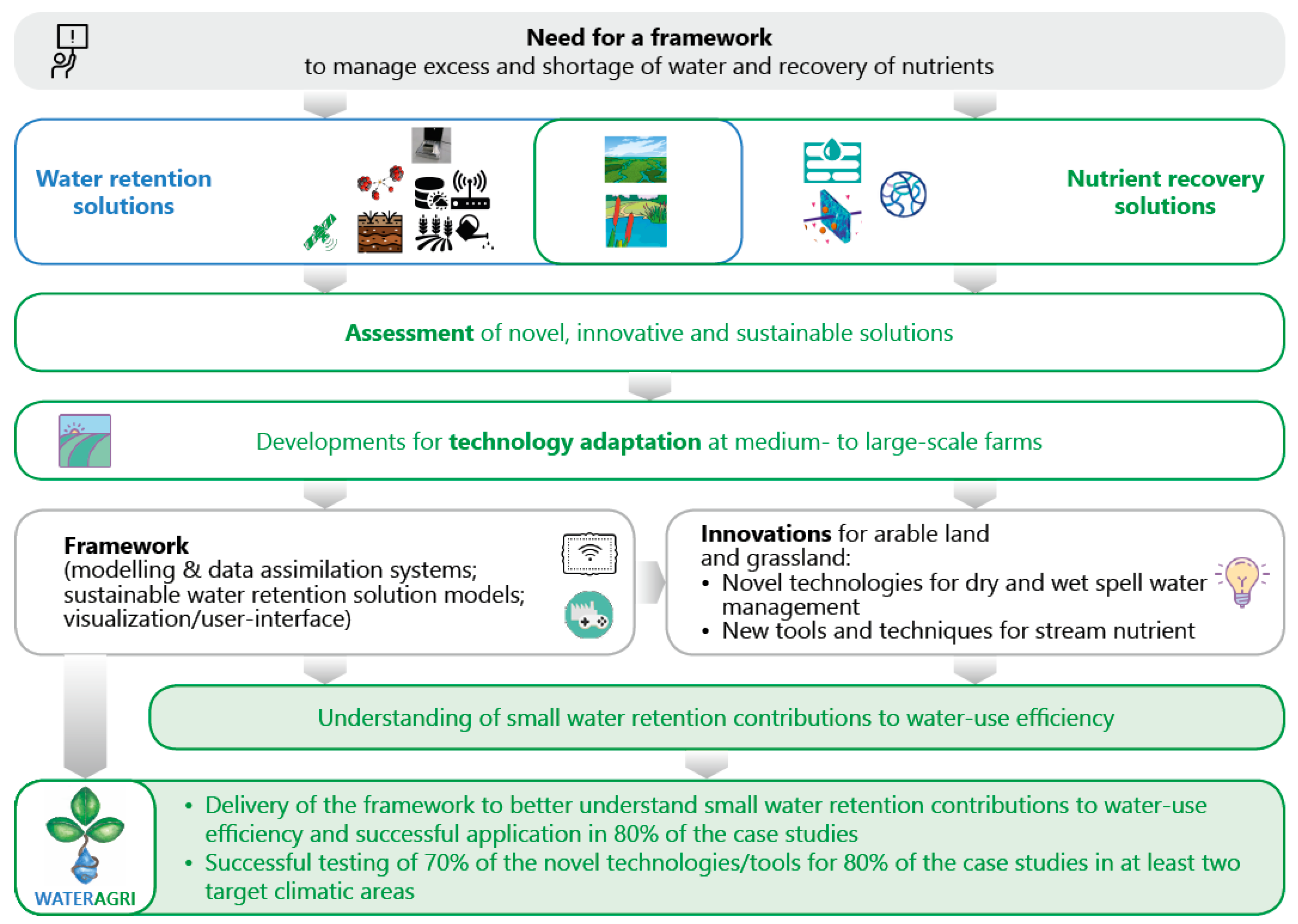
3. Solutions and Their Expected Impacts

3.1. Potential Solutions and Their Direct Expected Impacts

Water and food security as well as climate change challenges may be addressed with various solutions, such as new technologies, methods, procedures, guidelines, models and educational tools. It is likely that there are many solutions that address these challenges. However, WATERAGRI focused only on promising innovations, which are summarized in Table 1. The purpose of the project was to evaluate them and to further develop the most promising solutions that are not ready to reach the market yet. The innovations in Table 1 are categorized into four groups: Framework and Modeling Tools (Group A), Sustainable Water Retention Solutions (Group B), Sustainable Water Retention and Nutrient Recovery Solutions (Group C) and Nutrient Recovery Solutions (Group D).
The technology readiness levels (TRLs) referred to in Table 1 follow these definitions: TRL 1, basic principles observed; TRL 2, technology concept formulated; TRL 3, experimental proof of concept; TRL 4, technology validated in the laboratory; TRL 5, technology validated by a farm; TRL 6, technology demonstrated within a farm catchment; TRL 7, innovation prototype demonstrated in the operational environment; TRL 8, innovation complete and qualified; and TRL 9, actual innovation proven in the operational environment and manufactured. While the initial TRLs have been determined according to the above definitions, the final TRLs are only predictions for 2024/2025.
The paragraphs below further describe some of the key innovations (Table 1) and their expected impacts. The WATERAGRI Modeling Framework (Table 1; A1) is capable of simulating water, energy and nutrient cycles in the soil, groundwater, surface water, vegetation and engineering structures in a coupled manner, thus reflecting the complexity of agricultural systems. The measurement data from online and in situ sensors include soil moisture content, groundwater levels, stream discharge, crop state and water levels in retention reservoirs and drains. In addition, remotely sensed observations such as soil moisture content and leaf area index are also assimilated.
Near-real-time integrated model predictions informed by in situ and remote online measurements will allow farmers to take the best decisions to increase the efficiency of input use. The input efficiency increase generates economic benefits for farmers while increasing the sustainable use of water resources. Existing infrastructure can be integrated into the modeling system to maximize water retention and efficiency [9].
Figure 2 indicates the data gathering and analysis approaches within the WATERAGRI Modeling Framework. They integrate the key innovations developed (Table 1). Multiple sensors covering different temporal and spatial scales in the catchments have been developed. The data collected constitute, for example, hydraulic heads and soil moisture information as well as discharge and evapotranspiration measurements.
Within the cloud, data are stored within the framework, allowing for subsequent information extraction. Digital surface models of selected catchments have been generated using airborne laser scanning data and local data densification based on photogrammetric or laser scanning data collected with an unmanned aerial vehicle for selected sites. Relevant processes and catchment features have been implemented for selected catchments.
The Irrigation Model (Table 1; A4) integrates remote sensing technology to analyze crop development and variation over time. The model also integrates sensor data, networks, monitoring tools, forecast models and decision support functionalities. The Irrigation Model provides critical input to the integrated and physically based modeling system. The WVSI-WRC and hydraulic conductivity models provide well-defined groundwater conditions at varying water saturation degrees in relation to climate and crop farming, which play a key part in the whole Irrigation Model.
In contrast to conventional models used in unsaturated subsurface hydrology, which are empirical, the WVSI-WRC model (Table 1; A5) is based on the underlying physics of pore surface adsorption and capillary condensation. For this reason, the parameters in the model have physical meaning. This provides the advantage of using the model to optimize the implementation of the new technologies and the design of water retention products in terms of their underlying physics. On the other hand, the model can be validated using the data collected from laboratory tests and field observation.
The Serious Game (Table 1 (A7) and Section 8) can be used to facilitate decision making in real situations. This is possible because the interactive gaming environment enables different stakeholders to simulate and quantify the impact of their decisions on technical, economic and environmental aspects of the analyzed problem, should they choose to do so. Subsequently, stakeholders will learn to have a greater appreciation of trade-offs that exist between different water retention options and agricultural production, increasing framework acceptance [10].
The Remote Sensing Pipeline (Table 1 (B1), Figure 3 and Section 7) operates in the short-wave infrared spectrum to measure soil moisture and vegetation water stress, and it uses a combination of visible near-infrared light and radar observations to measure vegetation densities and phenological stages (where possible). These measurements are used to calibrate the WVSI-WRC model (Table 1). This helps farmers to decide upon and characterize the variation in the model parameters, which will be integrated into the database of the framework. The soil moisture and vegetation water stress data are integrated in the cloud (Figure 2) and can be used to inform real-time models for short-term predictions. The use of dense sub-weekly time series of multispectral imagery satellites (3–10 m spatial resolution) from both the Copernicus program and private actors makes the monitoring of crop biophysical parameters feasible.
Remote sensing applications help to assign water and fertilizer demands for different crop and soil types. The pipeline B1 improves decision support by providing data. The overview quantifies and benchmarks changes. The identification of plant water leads to spatially optimized water use, supporting efficient water irrigation and lower costs. Remote sensing data will help to identify effective innovations. The data are cost-effective and useful in measuring important indicators during dry and wet spells, improving water management.
The analysis of remote sensing results has its limitations, as reported by WATERAGRI researchers. The assessment of output may show differences with, for example, different satellite image resolutions and spectral analysis methods. Moreover, it is sometimes hard to collect appropriate satellite images because of cloud obstructions.
The Irrigation Management and Agrometeorological Monitoring Solution (Table 1; B2) is used to help farmers, agronomists and farm advisers to manage irrigation scheduling and crop stress in real time, ensuring optimal production while reducing water use, energy consumption and environmental impact. Stress management and irrigation advice services have the purpose of covering the entire irrigation process, ensuring optimal production all season long and planning farm operation and management strategies based on current crop needs and weather conditions.
The Precision Irrigation System (Table 1; B3) is integrated with a decision support system. The irrigation plan encoded in the decision support system is based on the prediction of the soil water content in the root zone and daily crop water requirements using a water balance model, which combines crop, weather and soil databases as well as historical and forecast weather data. The main functions of the decision support system include real-time irrigation management, decision-making support, user-customized irrigation scheduling, simulation of soil water dynamics in the root zone, evaluation of the effect of certain irrigation schedules on crop yield reduction and database management.
The crop simulation model and the water requirement calculations of the decision support system work on a daily time step. The modeling approach is based on the continuity equation, which is applied to the soil layer explored by roots. Crop evapotranspiration losses are evaluated at the field level with an algorithm that simulates the reference crop evapotranspiration, the maximum crop evapotranspiration and the real crop evapotranspiration.
The Precision Irrigation System output, which is updated daily, includes the following information: crop water status and irrigation requirements, as well as temporal patterns of soil moisture levels compared to upper (optimal soil moisture status to be reached with irrigation) and lower (beginning of stress, when irrigation is mandatory) thresholds. Additional data output provided by the model includes the phenological phase, crop coefficient and water stress coefficient. Likewise, numerical models simulating the surface and subsurface resources can be linked to this decision support system. This allows end-users to analyze how providing irrigation water will affect water storage in surface and subsurface reservoirs in the short and long term. It also allows studying the effect of in-stream measures on soil moisture storage. This is a central precondition for improved water retention.
In general, the water retainer product helps the ground to maintain a steady water balance by reducing evaporation. Water retainers are often organic soil conditioner liquids helping plants to take up water and diminish the effects of drought and dehydration. WATERAGRI has used a water retainer product in different conditions and provided the research background to product development activities by investigating the effects of the water retainer on the soil ecosystem using molecular biology methods. Furthermore, the WVSI-WRC model was used to model and characterize the performance of the biodegradable water retainer product to help improve its design and quality. These actions resulted in the Enhanced Water Retainer Product and Concept (Table 1; B4).
The organic water retainer B4 reduces evaporation, regulates the water balance and stops water seepage deeper into the soil. The retainer effectively compensates for dry spells by increasing the soil’s water storage capacity. Plants should then maintain an acceptable yield of high quality. Soil is then also more likely not to be water-repellent.
Advanced Tracer Methods (Table 1 (B5) and Section 6) are used to analyze the stable isotopes of water in the pore water of soils. Advanced water–vapor equilibration techniques allow measuring the isotopic composition of pore water in high-resolution soil cores. Corresponding data can be used to quantify water fluxes and improve the calibration of subsurface models (soil and groundwater), thus reducing their predictive uncertainties.
The DET Apparatus (Table 1; B6) data should allow for better management decisions regarding the selection of dewatering technology. The test can also be used to evaluate the water retention capacity of different soils and sludge within the agricultural industry [11]. Moreover, B6 will help in the identification of economically sustainable technologies and methods for the dry- and wet-spell water management of soil and sludge.
The DET is almost as simple as the capillary suction test, but it is more reliable, faster, flexible and informative in terms of the visual measurement data collected with modern image analysis software. The standard deviations associated with repeated measurements for the same sludge are lower for the DET than for the capillary suction test. In contrast to the capillary suction time test device, capillary suction in the DET test is linear and not radial, allowing for a straightforward interpretation of findings [11].
Farm Constructed Wetlands (Table 1 (C1) and Section 4 and Section 5) can be used for sustainable water retention and nutrient recycling. The analysis and modeling of soil moisture retention with drainage level controls, vegetated buffer zones and nutrient retention in wetlands [5] for water management considered the need for adaptation to climate change and its impact on ecosystem services [7] such as flood control.
Wetland design recommendations taking variation into account should improve seasonal water retention. Modeling helps to identify the tools and techniques for successful waste stream nutrient recovery. The modeling results support the assessment of the economic impact and management strategies.
Considerable nutrient loads are released to semi-natural waterbodies such as wetlands due to inefficient (artificial) fertilizer usage and insufficiently treated agricultural wastewater. There is considerable economic and environmental potential to capture these nutrients and reuse them in agriculture [8]. Recovered nutrients from wetlands can be used to grow crops [4].
Biochar Absorbents (Table 1; C2) have been shown to increase both the soil water holding capacity and the available water capacity. Moreover, C2 acts as a nutrient adsorbent from the runoff water. However, the biochar’s efficiency depends on its properties, soil texture, raw material(s) and pyrolysis conditions. Char activation should improve the nutrient adsorptive performance.
The WVSI-WRC model can be used to characterize the performance of the biochar’s efficiency. This should result in a quantified assessment of surface adsorption and soil water holding capacity improvements. Such assessments can guide the improvement of current product design and manufacturing processes.
The Bio-based Nutrient-Collecting Membrane (Table 1; D1) is made of nano-cellulose. With numerous surface-tailoring options, the membrane has the potential for selective nutrient capture. The production method is green and up-scalable and can thus be produced for various catchment scales and corresponding configurations. The biological structure opens the possibility of using the nutrient-rich membrane material after recovery for soil amendment and/or fertilization.
The Novel Drainage System (Table 1; D2) is based on a low-cost bio-inspired drainage technology that captures nutrients from runoff and streams. Different layers of material act like a rhizosphere to absorb and store nutrients in the soil, metabolize them and make them accessible to crops. The captured nutrients can further be used directly with crops with high nutrient uptake and subsequently be converted to biomass. Moreover, active drainage management (e.g., closing drains during drought conditions) improves the efficiency of irrigation and fertigation.
Microfluidics (Table 1; D3) can be integrated with wastewater treatment systems (Figure 4) for agricultural activities targeting nutrients within the operational context. This innovation is energetically efficient and designed to permit reagent recovery on an agricultural farm scale. The device is suitable for circular nutrient management. Furthermore, D3 allows for the flow of large volumes of contaminated water.

3.2. Expected Long-Term Case Study Impacts

Figure 5 provides an overview of all case study locations. The following paragraphs summarize the corresponding expected long-term impacts. The first Finnish case study may lead to the improvement of water regulation for potato farming and comprises the development of automatic drainage. Drainage water regulation for farming on mineral soils in the municipality of Tyrnävä, Northern Ostrobothnia, should be enhanced. The outcome comprises an integrated system for (a) automatic soil and drain water monitoring; (b) models of the soil water content; and (c) automatic control of drainage structures using in situ observations, remote sensing and control functions that should be operated by the farmer via a mobile phone. The monitoring, modeling and observation system is intended to optimize potato growth and water retention to limit irrigation and the leaching of nutrients. The system may detect flow in drain pipes to predict drain blockages and drain cleaning intervals.
The second Finnish site is used for grass production and is located in the municipality of Ruukki, Northern Ostrobothnia. The expected impact should be on water regulation to limit subsidence, nutrient leaching, acidity leaching (acid sulfate soils) and greenhouse gas emissions from organic soils, which are common in the boreal region.
In Sweden, Gårdstånga Nygård (GN; Figure 5) manages 200 ha of organic and 800 ha of conventional farmland, which is vulnerable to droughts. Conventional cultivation is undertaken according to FAO’s three principles of conservation agriculture [12]. The expected impact of applying the framework (A1), in addition to improving the planting sequence and field management, may comprise improved soil health, reduced leaching of nutrients and decreased carbon dioxide emissions from the soil. Sustainable water retention management should also include the construction of dikes, wetlands and reservoirs.
In France, a 4000 ha catchment near Auxerre has challenges with water polluted by pesticides and nitrates. The arable land relies on drainage pipes pouring into sinkholes. WATERAGRI innovations (Table 1) are designed to help farmers to adjust their crop rotations, nutrient management, controlled drainage and wetland technology.
The Selhausen agricultural research station in Germany consists of 51 agricultural fields covering 1 km2 and represents the heterogeneous rural area of the lower Rhine valley. The innovations should, with the help of field experiments, determine the drought stress responses of plants to optimize irrigation. The proposed framework (A1) may assist in the selection and management of crops such as sugar beet, winter wheat, winter barley, maize and rapeseed. The impact indicator is the expected production gain as a function of the amount of irrigation water.
In Poland, a farm of 500 ha is located in the lowland part of Lower Silesia and specializes in cereals. Despite having drainage system operations over the whole area, the farm struggles with both water shortages and local flooding. Online sensors to monitor soil moisture, the groundwater table, water outflow from the catchment and weather conditions should optimize water management. This should be achieved by identifying field locations with high water demand, assessing drainage conditions and implementing the framework (A1) for controlled drainage supported by small water retention solutions. Improved field nutrient doses may maintain high yields of cultivated crops and reduce the contamination of water within the catchment. The farm should benefit from improved water retention and quality. The expected impact should be on water management at the farm level to improve water availability, resulting in high yields of cultivated crops.
The framework (A1) was tested in collaboration with the largest vegetable farming association in Seeland, Switzerland. If current agricultural practices are continued, soil resources will be depleted in 50 years. The changing precipitation dynamics make future production targets vulnerable. The landscape in its current form is the result of a regional scale water correction and draining project. Through the drainage of the area, the upper soil layer in the region shrank drastically through mineralization. Furthermore, the growing population in the area makes it a challenge to develop new agricultural areas. The main requirement is the conservation of agricultural production.
WATERAGRI innovations (Table 1) should maintain a high level of food production in the long term through intelligent water, soil and nutrient management. It may optimize drainage management through real-time management, which is currently conducted in an uncoordinated manner by individual farmers. Moreover, the efficiency of costly investments such as new drainage systems or irrigation systems can be assessed under the consideration of climate change.
Near Vienna, Austria, is an experimental agricultural field already equipped with soil water measurement devices, where WATERAGRI in collaboration with a vocational training school for farmers investigates water flows on the farm level for the improvement of irrigation of different crops and for the sustainable use of water resources. WATERAGRI uses tracer and mathematical modeling approaches to assess water fluxes, water retention times and groundwater recharge rates.
In Italy, a 12.5 ha experimental farm of the Land Reclamation Consortium is located near Bologna (northern Italy; continental climate zone), and different crops (winter wheat, soya, maize, fruits, vegetables, etc.) are grown. Drainage water coming from the farm is treated by a 0.4 ha surface flow constructed wetland before discharge to surface water bodies. WATERAGRI innovations (Table 1) should optimize irrigation, water retention, agricultural drainage water treatment (e.g., pesticide removal) and nutrient recovery.
A Hungarian farm comprises 16 ha of pasture with sprinkler irrigation for cattle grazing and 50 ha of irrigated arable land in a nitrate-sensitive area (based on European guidelines). Excess water and purified fermentation sludge should be utilized as an alternative water source. The framework (A1) may help to evaluate alternative water source applications in variable-rate sprinkler irrigation technology. Irrigation technology demonstration guidelines contribute to the reduction in artificial fertilizers to adapt to climate change and a reduction in available conventional water resources.
The guidelines developed cover conventional and state-of-the-art methods for field monitoring for irrigation practice. The methods proposed include technology for the utilization of excess water coming from small water retention measures and treated water obtained from biogas production, as well as smart technologies for vegetation surveys for the spatial optimization of irrigation. The innovations are designed to enhance irrigation sustainability by reducing water discharge to both groundwater and surface water and should contribute to the reduction in artificial fertilizers to adapt to climate change through a reduction in available conventional water resources.

4. Nature-Based Solutions including Wetland Systems

WATERAGRI has a strong focus on nature-based solutions [13,14], including physical ones such as the Farm Constructed Wetland (C1), Biochar Adsorbents (C2) and Bio-based Nutrient-Collecting Membrane (D1) (Table 1). This section briefly outlines key characteristics of nature-based solutions in preparation for Section 5.
The interest in nature-based solutions is growing since these kinds of systems can help to mitigate the negative impacts of climate change and water pollution with reduced operational and maintenance costs. One of these negative effects is certainly agricultural water pollution and especially the release of nitrogen into water ecosystems. Different types of nature-based solutions can be used to prevent diffuse nitrogen pollution, and it is important to understand which processes can take place in these systems and which influencing factors can affect nitrogen removal [13,14].
Constructed wetlands were found to be the nature-based solution type used for both diffuse pollution control and point-source contamination removal [3,5]. Although vegetation plays an important role, through the special property of macrophytes of pumping oxygen from the leaves to the roots, plant uptake is not the major nitrogen removal route, according to WATERAGRI project review findings [15]. The wetland substrate is an important factor since it can provide a carbon source needed for denitrification, which was identified as the most important nitrogen removal pathway [16,17]. In this context, the presence of certain microbial species in constructed wetlands is crucial since they can influence processes such as nitrification and denitrification [3,5].
The scientific community has proposed different ways to enhance nitrogen abatement efficiency. For example, the use of hybrid constructed wetlands, which combine surface and subsurface constructed wetland systems, can promote nitrogen removal by exploiting the advantages of different wetland types. Moreover, aeration has proved beneficial since it can control the presence of oxygen inside the system and keep it at the optimum level when it is required [18]. It is also important to adjust operational parameters (e.g., hydraulic loading rate and hydraulic retention type) since they control system behavior [5]. Other nature-based solution types, such as buffer strips, vegetated channels and water sediment control basins, were found to have lower applicability due to either their low efficiency or their inability to manage variable and high water flows, typical of agricultural drainage water, according to a WATERAGRI review [14,15,19].
Finally, different nitrogen recovery strategies were studied in the past. For example, biochar substrate or algae biomass previously used in constructed wetlands for water treatment could be rich in nitrogen content. These materials can be later used to produce compost or soil amendments and therefore reduce the need for chemical fertilizers [20,21].

5. Wetland System Management

5.1. Management to Mitigate Climate Change

WATERAGRI focuses on wetland management to adapt to climate change and secure clean and sufficient water resources for the future. The appropriate management of Farm Constructed Wetlands (C1) could both mitigate and help adapt to climate change [5]. The use of collected and stored water in wetland systems for subsequent reuse as irrigation water is an easy adaptation measure during hot summers [4]. However, the optimized management of these systems to mitigate climate change is the focus of the first two sub-sections.
Water purification is one of the most essential services provided by wetlands [19]. However, climate change has been identified as a major threat to wetlands. Altered hydrology and rising temperature can change the biogeochemistry and function of a wetland to the degree that some important services might be turned into disservices. This means that they will, for example, no longer provide a water purification service, and conversely, they may start to decompose and release nutrients to the surface water. This might lead to serious ecological challenges, e.g., eutrophication and acidification. Moreover, a higher rate of decomposition than primary production (photosynthesis) may lead to a shift in their function from being a sink for carbon to a source, according to WATERAGRI publications [22,23,24,25]. It can also endanger the well-being and livelihood of populations that depend on these systems [26].
Salimi et al. [24] reviewed, on behalf of WATERAGRI, the potential response of natural wetlands (peatlands) and constructed wetlands to climate change in terms of gas emissions and nutrient release. In addition, the impact of key climatic factors, such as temperature and water availability, on wetlands has been assessed. The authors identified methodological gaps and weaknesses in the literature and then introduced a new framework for conducting a comprehensive mesocosm experiment to address the existing gaps in the literature to support future climate change research on wetland ecosystems.
In the future, higher temperatures resulting in drought might shift the role of both constructed wetlands and peatlands from sinks to sources of carbon. However, higher temperatures accompanied by more precipitation can promote photosynthesis to a degree that might exceed respiration and maintain the carbon sink role of the wetland [19]. There might be a critical water level at which the wetland can preserve most of its services. In order to find that level, a WATERAGRI study of the key factors of climate change and their interactions using an appropriate experimental method was necessary [24,25].
Some contradictory results of past experiments may be associated with different methodologies, designs, time periods, climates and natural variability. Hence, a long-term simulation of climate change for wetlands according to the proposed framework is recommended. This framework provides relatively more accurate and realistic simulations, valid comparative results and comprehensive understanding and supports coordination between researchers. This can help to find a sustainable management strategy for wetlands to be resilient to climate change, according to WATERAGRI [24].
Salimi and Scholz [24,25] assessed the effect of climate change on water quality in peatland and constructed wetland ecosystems subject to water level management as part of the WATERAGRI project. For this purpose, the authors simulated the current climate scenario based on the database from Malmö station (Scania, Sweden) for 2016 and 2017, as well as future climate scenarios for the last 30 years of the century based on the representative concentration pathway (RCP) and different regional climate models for a region wider than Scania County. For future climate change, the authors simulated low (RCP 2.6), moderate (RCP 4.5) and extreme (RCP 8.5) climate scenarios. All simulations were conducted within climate chambers for experimental peatland and constructed wetland mesocosms.
The results demonstrated that the effect of the climate scenario is significantly different for peatlands and constructed wetlands (interactive effect) for the combined chemical variables. The warmest climate scenario, RCP 8.5, is linked to a higher water purification function for constructed wetlands but to a lower water purification function and the subsequent deterioration of peatland water qualities, even if subjected to water level management. The explanation for the different responses of constructed wetlands and peatlands to climate change could be due to the fact that the substrate in the constructed wetland mesocosms and peatlands was different in terms of the organic matter quality and quantity [19]. Plants and microbial communities within the constructed wetlands readily use up all easily available nutrients when the temperature rises. In contrast, concerning the extreme scenario RCP 8.5, peatlands have shown a tendency to exhibit the reverse process in WATERAGRI mesocosm experiments [24,25].
Salimi et al. [25] highlight that stress factors such as climate change and drought may switch the role of temperate peatlands from carbon dioxide sinks to sources, leading to positive feedback to global climate change. Water level management has been regarded as an important WATERAGRI climate change mitigation strategy, as it can sustain the natural net carbon dioxide sink function of a peatland. Little is known about how resilient peatlands are in the face of future climate change scenarios or how effectively water level management can sustain the carbon dioxide sink function to mitigate global warming [19].
Salimi et al. [25] assessed the effect of climate change on carbon dioxide exchange in south Swedish temperate peatlands, which were either unmanaged or subject to water level regulation. Climate chamber simulations described previously [24] were conducted as part of WATERAGRI.
Published WATERAGRI results show that all managed and unmanaged systems under future climate scenarios could serve as carbon dioxide sinks throughout the experimental period. However, the 2018 extreme drought caused unmanaged mesocosms under RCP 4.5 and RCP 8.5 to switch from a net carbon dioxide sink to a source during summer. Surprisingly, unmanaged mesocosms under RCP 2.6 benefited from the warmer climate and served as the best sink among the other unmanaged systems. Water level management had the greatest effect on the carbon dioxide sink function under RCP 8.5 and RCP 4.5, which improved their carbon dioxide sink capability by up to six and two times, respectively. Under the current climate scenario, water level management had a negative effect on the carbon dioxide sink function, and it had almost no effect under RCP 2.6. Therefore, the researchers concluded that water level management is necessary for RCP 8.5, beneficial for RCP 4.5 and unimportant for RCP 2.6 and the current climate [25].

5.2. Application of the Van Genuchten–Mualem Models to Peat Soils

Undisturbed peatlands are effective carbon sinks and provide a variety of ecosystem services, such as adaptation and mitigation regarding climate change. However, anthropogenic disturbances, especially land drainage, strongly alter peat soil properties and jeopardize the benefits of peatlands. The effects of disturbances were therefore assessed and predicted as part of the WATERAGRI project [23,24,25]. To support accurate modeling, Menberu et al. [27] determined the physical and hydraulic properties of intact and disturbed peat samples collected from 59 sites (in total, 3073 samples) in Finland and Norway.
The bulk density, porosity and specific yield values obtained indicated that the top layer (0–30 cm depth) at agricultural and peat extraction sites was most affected by land use change. The bulk density in the top layer at agricultural, peat extraction and forestry sites was 441, 140 and 92% higher, respectively, than that of intact peatlands. Porosity decreased with increasing bulk density, but not linearly. Agricultural and peat extraction sites had the lowest saturated hydraulic conductivity and porosity and the highest bulk density among the land use options studied by the WATERAGRI team [27].
The van Genuchten–Mualem soil water retention curve and hydraulic conductivity models proved to be applicable for the peat soils tested, providing values of soil water retention curve, hydraulic conductivity and van Genuchten–Mualem parameters (α and n) for peat layers (top, middle and bottom) under different land uses. A decrease in peat soil water content of ≥10% reduced the unsaturated hydraulic conductivity values by two orders of magnitude. This unique data set can be used to improve hydrological modeling in peat-dominated catchments and for fuller integration of peat soils into large-scale hydrological models [27].
The outcomes of the above study [27] were fed directly into the WATERAGRI Modeling Framework (A1). They are particularly relevant for boreal climates (Figure 5), where there is a serious risk of peatland degradation as the climate becomes warmer. On the other hand, some of these peatlands may be transformed in a sustainable manner into farmland if, for example, the water level is managed appropriately.

5.3. Assessment of Plants Irrigated with Wastewater Treated by Wetlands

Wetlands can also contribute to irrigation water provision, especially in terms of non-conventional water resources (e.g., treated wastewater). There is a high potential to reduce the agricultural water demand by recycling different types of wastewaters in the irrigation of crops [4,19]. However, there is a need for sufficient pre-treatment to reduce potentially negative impacts, such as the pollution of crops by, for example, heavy metals. Moreover, groundwater resources need to be protected.
Almuktar et al. [28] assessed Capsicum annuum L. (chili; an easy-to-grow example plant) grown in controlled and semi-controlled environments irrigated with greywater treated by floating wetland systems as part of the WATERAGRI project. The accumulation of trace elements, including heavy metals, was evaluated in the soil and fruits of chili plants grown under both laboratory-controlled and semi-controlled greenhouse location conditions. Chili plant biomass growth in different development stages and fruit productivity were evaluated and compared with each other for the impact of growth boundary conditions and water quality effects. Treated synthetic greywaters in different operational design set-ups of floating treatment wetland systems were recycled for watering chilies in both locations. The effluents of each individual group of treatment set-up systems were labeled to feed sets of three replicates of chili plants in both locations.
WATERAGRI results revealed that the treated synthetic greywater complied with thresholds for irrigation water, except for high concentrations of phosphates, total suspended soils and some harmful trace elements such as cadmium. Chili plants grew in both locations with different growth patterns in each development stage. First blooming and high counts of flowers were observed in the laboratory. Higher fruit production was noted for greenhouse plants: 2266 chili fruits with a total weight of 16.824 kg with an expected market value of GBP 176.22 compared to 858 chili fruits from the laboratory with a weight of 3.869 kg and an estimated price of GBP 17.61 [28].
Trace element concentrations were detected in chili fruits with the ranking order of occurrence as follows: Mg > Ca > Na > Fe > Zn > Al > Mn > Cu > Cd > Cr > Ni > B. The highest concentrations of accumulated Cd (3.82 mg/kg), Cu (0.56 mg/kg) and Na (0.56 mg/kg) were recorded in chili fruits from the laboratory. Accumulations of Ca, Cd, Cu, Mn and Ni with concentrations of 4.73, 1.30, 0.20, 0.21 and 0.24 mg/kg, respectively, were linked to fruits from the greenhouse. Trace elements in chili plant soils followed the trend: Mg > Fe > Al > Cr > Mn > Cd > Cu > B. The accumulated concentrations in either chili fruits or the soil were above the maximum permissible thresholds, indicating the need for further water quality improvements [28].
The WATERAGRI findings [28] helped to understand practical challenges with the recycling of wastewater in farming. However, there is uncertainty about farmers not actually knowing what they put on their fields in terms of potential pollution loads and when these loads may become a challenge in the future for certain plants [4,19].

5.4. Simplified Models for Wetland Systems

Constructed treatment wetlands are systems designed to optimize chemical, physical and biogeochemical processes occurring in wetland ecosystems to treat wastewater [19]. The type of treatment wetland typically used to treat agricultural runoff is the free water surface wetland because of its strong ability to cope with pulse flows [3]. According to WATERAGRI research, current design guidelines for these systems are based on empirical rules of thumb and/or simple first-order decay models, which are based on experimental data with pilot plants and specific boundary conditions such as climatic conditions or wastewater composition [5,29].
In addition, free water surface wetlands are designed and used according to the experiences and needs of each region [5,19]. For example, in boreal biogeographical areas (Figure 5), wetlands are mostly used for phosphorus retention, while in warmer bioclimatic regions, with optimal conditions for nitrifying bacteria, they are used to remove nitrogen. The design is mainly based on hydraulic criteria by improving the hydraulic efficiency or increasing the hydraulic retention time, i.e., adding obstacles, increasing the aspect ratio (length to width) or calculating the wetland surface area in relation to the catchment area.
Process-based modeling is also advanced, and there are many studies on wetland performance. However, these models require advanced modeling skills and specific parameters that are impossible to obtain if the wetland is not yet constructed. Therefore, some researchers encourage the development of simplified models where only a few parameters are required [5,19]. Current simplified design tools are only available for combined sewer overflow wetlands, i.e., RSF_Sim [30] and ORAGE [31]. These models have proven to be robust and reliable for design purposes [32].
As part of WATERAGRI [1], researchers [33] compared the performance of different simple models using data from a full-scale wetland monitored over the long term located in the Emilia-Romagna region, Italy. The models simulated the transport and removal of total nitrogen in two precipitation events with different characteristics. Moreover, the models were evaluated under steady- and unsteady-state conditions. The best performance was achieved with a tanks-in-series model coupled with a first-order degradation model with non-zero background concentration for pollutant degradation. The simulations under steady-state conditions were able to simulate outflow total nitrogen concentrations even though the inputs were discontinuous. In contrast, the piston flow with the dispersion model did not fit the wetland hydraulics in either event due to the nature of wetlands, which receive water in pulses following rainfall events.
A simplified model can be very useful for rough assessments and can be used for the upfront design, which would help decision making. The WATERAGRI findings will help to set performance ranges for certain conditions, which will provide insight into the real possibilities and limitations of free water surface wetlands. The adaptations have been incorporated into the WATERAGRI Modeling Framework (A1).

6. Tracer Methods

6.1. Background on Isotopes

Advanced Tracer Methods (B5; Table 1) have been developed as part of WATERAGRI [1] to assess more complex water retention challenges. Stable oxygen (O) and hydrogen (H) isotopes of water (δ18O and δ2H) can be applied as environmental and conservative tracers and are inherent compounds of the water cycle used to understand hydrological processes in agricultural soils. The isotopic composition of precipitation is modified by fractionation processes, resulting in distinct seasonal and geographical distributions, generating a global distribution map [34].
Seasonal tracer variations may still be observed in the pore water of soils, with the attenuation of the signal depending on transport processes (i.e., dispersion and diffusion). Thus, the measurement of δ18O and δ2H in pore water allows for tracking water from different precipitation events in the unsaturated zone, providing integrative information about the sources, flow and transport of water at large scales and in long time series [35]. Combined with the analysis of soil water content, water fluxes such as mobile soil water or potential groundwater recharge can be quantified [36,37]. Using a water balance approach, other fluxes (e.g., evapotranspiration) can be estimated as well, which has been shown in WATERAGRI studies [38,39,40].

6.2. Standard Method Development

For analyzing isotopes in pore water, the water–vapor equilibration concept can be used. This method does not require the extraction of pore water like other methods, such as cryogenic water extraction. A rock or sediment sample is placed into a sealable, inflatable and leak-tight bag (usually a plastic Ziploc® bag or laminated Al-bags). The bag is inflated with dry air and equilibrated for up to three days. Within the closed system, water and vapor are in equilibrium (the water amount and the isotopic composition), and the isotopic composition of the vapor is analyzed with laser spectroscopy.
No standard protocols for this type of method currently exist; e.g., different laboratories have various equilibration times. It follows that it needs to be tested whether the equilibration time, soil texture and pore water saturation have effects on isotopic results using the water–vapor equilibration method. Therefore, stable water isotopes were analyzed as part of WATERAGRI in soil samples with different textures (sand, silty loam and clay (kaolinite)) and different soil saturation levels (40–100%) using different equilibration times (24 to 168 h) [41].
The findings showed that a 24 h equilibration time was sufficient for sandy soils at all tested saturation levels. For kaolinite, little variance with equilibration time was found. For silty loam containing organic carbon (2% and 4%), the method indicated that equilibration could only be obtained with difficulty. Nevertheless, disaggregation of samples generally improved the isotope analysis [41]. This means that further tests are required to understand the effect of the presence of organic carbon on water–vapor equilibration. It also means that the water–vapor equilibration method can be generally applied, and equilibration times can be adjusted according to the individual soil type and water content of the target farm.

6.3. Application in Agricultural Water Management

Sustainable agriculture should be based on management practices that improve resource usage efficiency and minimize harmful impacts on the environment while maintaining and stabilizing crop production [1]. Both tillage and irrigation can have a great influence on hydrological processes within agroecosystems. However, it remains difficult to directly assess the effect of various agricultural practices on water fluxes, which have been mainly indirectly quantified by complex numerical modeling methods in the past. Whether isotope approaches also allow for the assessment of the impact of management practices on water fluxes in agricultural soils still remains to be tested. It would serve as a simple approach to obtain basic information on hydrological processes in agroecosystems from single sampling campaigns that can be used even in remote farming areas.
As part of the WATERAGRI project [1], Canet-Marti et al. [42] assessed hydrological processes and water flux quantification in agricultural fields under different tillage and irrigation systems using stable water isotopes. In order to support sustainable agricultural water management practices, the objective of their study was to use a space-for-time concept and measure oxygen (O) and hydrogen (H) isotopes (δ18O, δ2H) in the pore water of soil profiles as well as moisture contents for quantifying the soil water balance and fluxes. Covering all combinations, soil profiles and isotope analysis was performed for 16 sites planted with winter wheat and managed with different tillage (conventional tillage, reduced tillage, minimal tillage and no-tillage) and irrigation systems (hose reel boom irrigation with nozzles, sprinkler irrigation, drip irrigation and no irrigation).
The results indicated that the more intense the tillage, the lower the water content. Among the irrigation systems, drip irrigation had the highest average water content. Tracing the minimum in the isotopic composition in the pore water within the depth profiles showed the deeper percolation of water in the conventional tillage fields, which indicates higher water flow velocity. Considering both water content and differences in water flow velocities resulted in water fluxes ranging from 46 to 91 mm per annum. The losses due to evapotranspiration varied between 80% and 91%. The resulting evapotranspiration within tillage and irrigation variants decreased in this order: conventional tillage > reduced tillage > minimal tillage > no-tillage, and sprinkler irrigation > hose reel boom irrigation with nozzles > drip irrigation > no irrigation.
The new method revealed that the lower water content in conventional tillage fields is a consequence of deeper water infiltration and higher evapotranspiration. Moreover, irrigation water contributed mostly to evapotranspiration, and drip irrigation showed the lowest evapotranspiration losses among irrigation systems. This WATERAGRI study demonstrated that stable water isotopes can be used as indicators and are a promising method to quantify water fluxes in agricultural fields with great potential for evaluating management practices [42].

7. Yield Forecasting Using Remote Sensing

Since global trading prices of agricultural commodities depend largely on their seasonal production levels, the total size of the cropping area and crop yields are important for export–import companies, agricultural agencies at national and international levels, government agencies and other crop marketing agencies. Furthermore, due to the increasing global demand for food grains, early and reliable information on crop production is important from a humanitarian point of view as well as to organize emergency response and food aid interventions [43].
WATERAGRI is further developing the Remote Sensing Pipeline (B1; Table 1) for the agricultural industry, because remote sensing has become a widespread technique used in agriculture and agronomy [44], and the interest in using remotely sensed satellite data for crop monitoring and crop production forecasting has increased, as it produces uniform data at the global scale, and modeling results can potentially be utilized in large regions. Reliable and early yield forecasts are also needed by farmers to implement adaptation measures (usually technical measures) to reduce the risk of potential yield loss at the farm level. Providing and developing a monitoring basis can be an important step forward in improving crop yields. Moreover, remote sensing is capable of providing temporal (and potentially real-time) and objective data on crop vigor, density, health and productivity, because remotely sensed data are in close relation to the canopy leaf area index and the fraction of absorbed photosynthetically active radiation [45].
Green vegetation can be monitored through its spectral reflectance properties [46]. The normalized difference vegetation index (NDVI) is an appropriate solution to monitor the total wheat dry-matter accumulation, since, in the growing season, the NDVI explains 79% of the wheat dry-biomass variations. Moreover, in minimizing the distribution of the effects on the relationships between vegetation spectral reflectance and crop yield, some researchers refer to distance-based vegetation indices, such as the soil-adjusted vegetation index [47]. This index is applied to correct the NDVI for the influence of soil brightness in areas where vegetative cover is low.
In the previous decades, the National Oceanic and Atmospheric Administration’s advanced very high resolution radiometer has been the main data source since the 1980s for large-scale crop yield forecasting and monitoring. Recently, remote-sensing-based yield forecasting research has shifted to the National Aeronautics and Space Administration’s moderate resolution imaging spectroradiometer and other satellites such as Landsat, SPOT (satellite for the observation of the earth) or Sentinel satellites, which provide data at a better spatial resolution. However, there are considerable limitations (i.e., information on crop rotation, small field sizes and the extension of locally calibrated models to other areas) of using remotely sensed satellite data in crop yield forecasting [43]. Information on long-term yield variability is important for tailoring farming practices to the needs of crops. In particular, remotely sensed vegetation indices such as the NDVI [48,49] and soil-adjusted vegetation index [50] have been widely utilized for agricultural mapping and monitoring. Several studies, including WATERAGRI, found that the soil-adjusted vegetation index achieved higher accuracies than the NDVI, suggesting that the former index reduced some of the effects of soil background reflectance [51,52,53].
The developed wheat yield forecasting model provides timely information on the production of wheat, as well as its status and yield, in a regular and standardized manner at field and catchment levels. From NDVI and soil-adjusted vegetation index forecasting models that were developed based on six training years, the yield can be predicted six weeks earlier before harvesting. These WATERAGRI findings can reduce the impacts of possible yield losses if delivered to farmers or decision makers in a timely and appropriate format, and if mitigation measures and preparedness plans are in place [51,54].
Nowadays, irrigation is one of the answers to drought mitigation. Irrigation is usually based on the measurement of soil water content or meteorological parameters to model or calculate evapotranspiration. In addition, the use of various proximal sensors is possible to measure pigment activity related to the photosynthetic activity [55,56], and multispectral cameras provide images with high spatial and temporal resolution, which are also suitable for assessing vegetation coverage and typology as well as biomass and vegetation monitoring data. Plant-based methods such as the plant water stress index have great potential for controlling irrigation, although there may be challenges in setting reference or threshold values [57]. The impact of irrigation management on the use of plant water is a practical consideration to improve yield and water productivity for plants. Based on the results, crop sensors equipped with linear irrigation equipment in the field are suitable for NDVI assessment and monitoring of the area in both irrigated and non-irrigated areas. Furthermore, pigments can be derived not only based on NDVI images but also based on the area ratio, and the biomass weight of maize can also be predicted. The use of virtual field sensors can help farmers to improve irrigation management for increased water savings and better crop production. According to WATERAGRI output, the verification of remotely sensed data is one of the prerequisites for the proper utilization and understanding of the data and their translation into leaf area, biomass amount, then evapotranspiration and eventually irrigation requirements [51,54].

8. Game for Decision Support and Stakeholder Engagement

Sustainable agricultural water management is a complex problem characterized by multiple alternatives, conflicting objectives and multiple uncertainties about key drivers such as climate change, land use change, legislative restrictions, population growth and increasing urbanization [1]. Serious games are becoming a popular means to support decision makers who are responsible for the planning and management of water systems. This is evident in the number of articles about serious games in recent years [58]. However, the effectiveness of these games in improving decision making and the quality of their design and evaluation approaches remains unclear.
In support of WATERAGRI, Mittal et al. [58] identified 41 serious games predominantly covering the urban water cycle and shortlisted 15 games for a detailed review. By using common rational decision-making and game design phases from the literature, the authors evaluated and mapped how the shortlisted games contribute to these phases. The findings show that current serious game applications fall short due to multiple limitations: (a) a lack of focus on executing the initial phases of decision making (phase 1 for problem structuring, phase 2 for defining objectives and attributes, and phase 3 for developing alternatives); (b) the limited use of storytelling and adaptive game elements; (c) the use of low-quality evaluation designs and explicit indicators to measure game outcomes; and (d) a lack of attention to the cognitive processes of players playing the game.
Addressing the above limitations and improving on them is critical to advancing a purposeful game design supporting agricultural water management. Therefore, WATERAGRI has developed a Serious Game (A7) that addresses these challenges and transfers existing knowledge from urban to rural areas.
A clear understanding of the needs and typical characteristics of target audiences, such as farmers or the general public, is an essential part of the WATERAGRI dissemination plan, which will ensure that communication channels are appropriate for the types of messages being sent. Table 2 gives an overview of the three levels of dissemination strategy impacts on stakeholder groups. The Serious Game directly supports dissemination for action as well as understanding and uptake.

9. Conclusions and Recommendations

This communication highlights research outputs linked to selected innovations that have been further developed as part of the Horizon 2020 WATERAGRI project to address water and food security challenges by optimizing sustainable agricultural water management and nutrient recycling strategies.
A review of factors that can influence nitrogen and phosphorus removal in different types of nature-based solutions was performed. The proposed framework for undertaking wetland experiments provides relatively more accurate and realistic simulations, valid comparative results and comprehensive understanding and supports coordination between researchers. This can help to find a sustainable management strategy for Farm Constructed Wetlands to increase resilience to climate change.
Our results using mesocosms in climate chambers demonstrate that the effect of the climate scenario is significantly different for peatlands and constructed wetlands (interactive effect) for combined chemical variables for a continental climate. The warmest climate scenario, RCP 8.5, is linked to a higher water purification function for constructed wetlands but to a lower water purification function and the subsequent deterioration of peatland water qualities, even if subjected to water level management.
The unmanaged mesocosms under RCP 2.6 benefited from the warmer climate and served as the best sink compared to other unmanaged systems. Water level management had the greatest effect on the carbon dioxide sink function under RCP 8.5 and RCP 4.5, which improved their carbon dioxide sink capability by up to six and two times, respectively. Water level management is necessary for RCP 8.5, beneficial for RCP 4.5 and unimportant for RCP 2.6 and the current climate. WATERAGRI encourages the development of simplified wetland models of systems where only a few parameters are needed or where there are insufficient data. Furthermore, similar wetland experiments should also be performed for boreal climate scenarios, and linked environmental impact assessments on natural resources on the field scale need to be undertaken.
Advanced Tracer Methods (B5) have the potential to compare the influence of different management practices on hydrological processes. Such practices may include tillage in agricultural land management, water level management and irrigation.
The Remote Sensing Pipeline (B5) uses remote-sensing-based yield forecasting models to provide estimations of wheat yield during the growing season well before the Biologische Bundesanstalt, Bundessortenamt und Chemische Industrie (BBCH) 41 development stage (i.e., when the flag leaf sheath is extending), which fosters preparedness for the mitigation of water shortage and for increased food security. The use of virtual field sensors can help practitioners to improve irrigation management for increased water savings and better vegetation production. The verification of remotely sensed data is one of the prerequisites for the proper utilization and understanding of the data and their translation into leaf area, biomass amount, then evapotranspiration and eventually irrigation requirements. The limitations of remote sensing technology linked to poor visibility due to, for example, cloud cover have been highlighted.
Our research shows that current serious game applications fall short due to a lack of attention to the initial phases of decision making, the limited use of storytelling and adaptive elements, low-quality evaluation of games without the use of explicit decision quality indicators and, lastly, a lack of attention to the cognitive processes of players playing the game. Improving these limitations is critical to advancing a purposeful Serious Game design for decision support in agricultural water management.
This communication has its limitations, as it predominantly assesses key findings of the WATERAGRI project and focuses heavily on the continental, boreal and Pannonian climatic regions of Europe and similar regions elsewhere. Therefore, the authors recommend assessing the same and other promising solutions to improve water and food security also for more climate zones. Moreover, further market development actions, including business modeling of the best innovations, need to be performed after the end of WATERAGRI.

Funding

This work was financially predominantly supported by WATERAGRI (European Union Horizon 2020 research and innovation program under Grant Agreement Number 858735) but also by other funding bodies, such as VINNOVA (Swedish government innovation agency), RainSolutions (Water JPI 2018 Joint Call project) and EcoDiver (Naturvårdsverket (Swedish Government Innovation Agency)).

Institutional Review Board Statement

Not applicable.

Informed Consent Statement

Not applicable.

Data Availability Statement

The data that support the findings of this communication are available from the corresponding author upon reasonable request. Most data and findings are also available as deliverables in the public domain via European Commission websites.

Acknowledgments

The support provided by all WATERAGRI partners is acknowledged. The following individuals provided small unedited text passages: Stevo Lavrnic (ALMA MATER STUDIORUM UNIVERSITA DI BOLOGNA), Attila Nagy (DEBRECENI EGYETEM), Tamara Avellán (OULUN YLIOPISTO), Christine Stumpp, Günter Langergraber and Alba Canet (all three from the UNIVERSITAET FUER BODENKULTUR WIEN) as well as Zoran Kapelan and Aashna Mittal (both from the TECHNISCHE UNIVERSITEIT DELFT).

Conflicts of Interest

Miklas Scholz is the Project Coordinator of WATERAGRI. He is also one of the official inventors of the dewaterability test apparatus. The funders had no role in the design of the study, in the collection, analyses or interpretation of data, in the writing of the manuscript or in the decision to publish the results.

References

  1. WATERAGRI. WATer Retention and Nutrient Recycling in Soils and Streams for Improved AGRIicultural Production (WATERAGRI). 2022. Available online: https://wateragri.eu (accessed on 24 March 2022).
  2. United Nations. The Sustainable Development Goals Report; United Nations: New York, NY, USA, 2021; Available online: https://www.un.org/en/desa/sustainable-development-goals-sdgs (accessed on 10 April 2022).
  3. Scholz, M.; Harrington, R.; Carroll, P.; Mustafa, A. The Integrated Constructed Wetlands (ICW) concept. Wetlands 2007, 27, 337–354. [Google Scholar] [CrossRef]
  4. Almuktar, S.A.A.-A.N.; Scholz, M. Mineral and biological contamination of soil and Capsicum annuum irrigated with recycled domestic wastewater. Agric. Water Manag. 2016, 167, 95–109. [Google Scholar] [CrossRef]
  5. Carty, A.; Scholz, M.; Heal, K.; Gouriveau, F.; Mustafa, A. The universal design, operation and maintenance guidelines for Farm Constructed Wetlands (FCW) in temperate climates. Bioresour. Technol. 2008, 99, 6780–6792. [Google Scholar] [CrossRef] [PubMed]
  6. Mohammed, R.; Scholz, M. Adaptation strategy to mitigate the impact of climate change on water resources in arid and semi-arid regions: A Case Study. Water Resour. Manag. 2017, 31, 3557–3573. [Google Scholar] [CrossRef] [Green Version]
  7. Mak, C.; Scholz, M.; James, P. Sustainable Drainage System site assessment using urban ecosystem services. Urban Ecosyst. 2017, 20, 293–307. [Google Scholar] [CrossRef] [Green Version]
  8. European Commission. Water Reuse—Proposal for a Regulation on Minimum Requirements for Water Reuse. Available online: http://ec.europa.eu/environment/water/reuse.htm (accessed on 24 March 2022).
  9. Hendricks Franssen, H.-J.; Brunner, P. Integrating hydrological modelling, data assimilation and cloud computing for real-time management of water resources. Environ. Model. Softw. 2017, 93, 418–435. [Google Scholar] [CrossRef] [Green Version]
  10. Reed, M.S.; Graves, A.; Dandy, N.; Posthumus, H.; Hubacek, K.; Morris, J.; Prell, C.; Quinn, C.H.; Stringer, L.C. ‘Who’s in and why? A typology of stakeholder analysis methods for natural resource management. J. Environ. Manag. 2009, 90, 1933–1949. [Google Scholar] [CrossRef]
  11. Scholz, M.; Almuktar, S.; Clausner, C.; Antonacopoulos, A. Highlights of the novel Dewaterability Estimation Test (DET) device. Environ. Technol. 2019, 41, 2594–2602. [Google Scholar] [CrossRef] [Green Version]
  12. Food and Agricultural Organization of the United Nations (FAO). The 3 Principles of Conservational Agriculture. 2014. Available online: https://www.fao.org/emergencies/fao-in-action/stories/stories-detail/en/c/216752/?msclkid=28c4e794ab5411ec8df29a742367c0d2 (accessed on 24 March 2022).
  13. Food and Agricultural Organization of the United Nations (FAO). Nature-Based Solutions for Agricultural Water Management and Food Security. 2018. Available online: http://www.fao.org/3/CA2525EN/ca2525en.pdf (accessed on 24 March 2022).
  14. European Commission. Nature-Based Solutions. 2019. Available online: https://ec.europa.eu/research/environment/index.cfm?pg=nbs (accessed on 24 March 2022).
  15. Mancuso, G.; Bencresciuto, G.F.; Lavrnić, S.; Toscano, A. Diffuse water pollution from agriculture: A review of Nature-Based Solutions for nitrogen removal and recovery. Water 2021, 13, 1893. [Google Scholar] [CrossRef]
  16. Reddy, K.R.; D’Angelo, E.M. Biogeochemical indicators to evaluate pollutant removal efficiency in constructed wetlands. Water Sci. Technol. 1997, 35, 1–10. [Google Scholar] [CrossRef]
  17. Spieles, D.J.; Mitsch, W.J. The effects of season and hydrologic and chemical loading on nitrate retention in constructed wetlands: A comparison of low- and high nutrient riverine systems. Ecol. Eng. 2000, 14, 77–91. [Google Scholar] [CrossRef]
  18. Wu, H.; Fan, J.; Zhang, J.; Ngo, H.H.; Guo, W.; Hu, Z.; Lv, J. Optimization of organics and nitrogen removal in intermittently aerated vertical flow constructed wetlands: Effects of aeration time and aeration rate. Int. Biodeterior. Biodegrad. 2016, 113, 139–145. [Google Scholar] [CrossRef] [Green Version]
  19. Scholz, M. Sustainable Water Management: Engineering Solutions for a Variable Climate; Elsevier: Amsterdam, The Netherlands, 2018; ISBN 9780128162460. [Google Scholar]
  20. Ghezzehei, T.A.; Sarkhot, D.V.; Berhe, A.A. Biochar can be used to capture essential nutrients from dairy wastewater and improve soil physico-chemical properties. Solid Earth 2014, 5, 953–962. [Google Scholar] [CrossRef] [Green Version]
  21. Acién Fernández, F.G.; Gómez-Serrano, C.; Fernández-Sevilla, J.M. Recovery of nutrients from wastewaters using microalgae. Front. Sustain. Food Syst. 2018, 2, 59. [Google Scholar] [CrossRef] [Green Version]
  22. Loisel, J.; Gallego-Sala, A.V.; Amesbury, M.J.; Magnan, G.; Anshari, G.; Beilman, D.W.; Benavides, J.C.; Blewett, J.; Camill, P.; Charman, D.J.; et al. Expert assessment of future vulnerability of the global peatland carbon sink. Nat. Clim. Chang. 2021, 11, 70–77. [Google Scholar] [CrossRef]
  23. Salimi, S.; Scholz, M. Impact of future climate scenarios on peatland and constructed wetland water quality under water level management: A mesocosm experiment within climate chambers. J. Environ. Manag. 2021, 289, 112459. [Google Scholar] [CrossRef]
  24. Salimi, S.; Almuktar, S.; Scholz, M. The impact of climate change on wetland ecosystems: A critical review of experimental wetland mesocosms. J. Environ. Manag. 2021, 286, 112160. [Google Scholar] [CrossRef]
  25. Salimi, S.; Berggren, M.; Scholz, M. Response of the peatland carbon dioxide sink function to future climate change scenarios and water level management. Glob. Chang. Biol. 2021, 27, 5154–5168. [Google Scholar] [CrossRef]
  26. Raihan, F.; Hossain, M.M. Livelihood vulnerability assessments and adaptation strategies to climate change: A case study in Tanguar haor Sylhet. J. Water Clim. Chang. 2021, 12, 3448–3463. [Google Scholar] [CrossRef]
  27. Menberu, M.W.; Marttila, H.; Ronkanen, A.-K.; Haghighi, A.T.; Kløve, B. Hydraulic and Physical Properties of Managed and Intact Peatlands: Application of the Van Genuchten-Mualem Models to Peat Soils. Water Resour. Res. 2021, 57, e2020WR028624. [Google Scholar] [CrossRef]
  28. Almuktar, S.; Abed, S.N.; Scholz, M.; Uzomah, V.C. Assessment of Capsicum annuum L. grown in controlled and semi-controlled environments irrigated with greywater treated by floating wetland systems. Agronomy 2021, 11, 1817. [Google Scholar] [CrossRef]
  29. Langergraber, G. Numerical modelling: A tool for better constructed wetland design? Water Sci. Technol. 2011, 64, 14–21. [Google Scholar] [CrossRef] [PubMed]
  30. Meyer, D.; Dittmer, U. RSF_Sim—A simulation tool to support the design of constructed wetlands for combined sewer overflow treatment. Ecol. Eng. 2015, 80, 198–204. [Google Scholar] [CrossRef]
  31. Palfy, T.G.; Meyer, D.; Troesch, S.; Gourdon, R.; Olivier, L.; Molle, P. A single-output model for the dynamic design of constructed wetlands treating combined sewer overflow. Environ. Model. Softw. 2018, 102, 49–72. [Google Scholar] [CrossRef]
  32. Langergraber, G. Applying process-based models for subsurface flow treatment wetlands: Recent developments and challenges. Water 2017, 9, 5. [Google Scholar] [CrossRef] [Green Version]
  33. Canet-Marti, A.; Grüner, S.; Lavrnic, S.; Toscano, A.; Strech, T.; Langergraber, G. Comparison of simple models for total nitrogen removal in free-water surface wetlands. Water Sci. Technol. 2022, in press.
  34. Rozanski, K.; Araguasaraguas, L.; Gonfiantini, R. Relation between long-term trends of O-18 isotope composition of precipitation and climate. Science 1992, 258, 981–985. [Google Scholar] [CrossRef]
  35. Stumpp, C.; Bruggemann, N.; Wingate, L. Stable isotope approaches in vadose zone research. Vadose Zone J. 2018, 17, 1–7. [Google Scholar] [CrossRef]
  36. Barbecot, F.; Guillon, S.; Pili, E.; Larocque, M.; Gibert-Brunet, E.; Helie, J.F.; Noret, A.; Plain, C.; Schneider, V.; Mattei, A.; et al. Using water stable isotopes in the unsaturated zone to quantify recharge in two contrasted infiltration regimes. Vadose Zone J. 2018, 17, 1–13. [Google Scholar] [CrossRef] [Green Version]
  37. Chesnaux, R.; Stumpp, C. Advantages and challenges of using soil water isotopes to assess groundwater recharge dominated by snowmelt at a field study located in Canada. Hydrol. Sci. J. 2018, 63, 679–695. [Google Scholar] [CrossRef]
  38. Boumaiza, L.; Chesnaux, R.; Walter, J.; Stumpp, C. Assessing groundwater recharge and transpiration in a humid northern region dominated by snowmelt using vadose-zone depth profiles. Hydrogeol. J. 2020, 28, 2315–2329. [Google Scholar] [CrossRef]
  39. Boumaiza, L.; Chesnaux, R.; Walter, J.; Stumpp, C. Constraining a flow model with field measurements to assess water transit time through a vadose zone. Groundwater 2021, 59, 417–427. [Google Scholar] [CrossRef] [PubMed]
  40. Liebhard, G.; Klik, A.; Stumpp, C.; Nolz, R. Partitioning evapotranspiration using water stable isotopes and information from lysimeter experiments. Hydrol. Sci. J. 2022, 67, 646–661. [Google Scholar] [CrossRef]
  41. Vadibeler, D.; Stockinger, M.P.; Wassenaar, L.I.; Stumpp, C. Influence of equilibration time, soil texture, and saturation on the accuracy of porewater water isotope assays using the direct H2O(liquid)-H2O(vapor) equilibration method. J. Hydrol. 2022, 607, 127560. [Google Scholar] [CrossRef]
  42. Canet-Marti, A.; Morales-Santos, A.; Nolz, R.; Langergraber, G.; Stumpp, C. Hydrological Processes and Water Flux Quantification in Agricultural Fields Under Different Tillage and Irrigation Systems Using Water Stable Isotopes. In Proceedings of the EGU General Assembly 2021, Online, 19–30 April 2021; p. EGU21-11039. [Google Scholar] [CrossRef]
  43. Rembold, F.; Atzberger, C.; Rojas, O.; Savin, I. Using low resolution satellite imagery for yield prediction and yield anomaly detection. Remote Sens. 2013, 11, 1704–1733. [Google Scholar] [CrossRef] [Green Version]
  44. Atzberger, C. Advances in remote sensing of agriculture: Context description, existing operational monitoring systems and major information needs. Remote Sens. 2013, 5, 949–981. [Google Scholar] [CrossRef] [Green Version]
  45. Jacobs, C.; Berglund, M.; Kurnik, B.; Dworak, T.; Marras, S.; Mereu, V.; Michetti, M. Climate change adaptation in the agriculture sector in Europe. EEA Rep. 2019, 4, 112. [Google Scholar] [CrossRef]
  46. Tucker, C. Red and photographic infrared linear combinations for monitoring vegetation. Remote Sens. Environ. 1979, 8, 127–150. [Google Scholar] [CrossRef] [Green Version]
  47. Huete, A.R. A Soil-Adjusted Vegetation Index (SAVI). Remote Sens. Environ. 1988, 25, 295–309. [Google Scholar] [CrossRef]
  48. Dempewolf, J.; Adusei, B.; Becker-Rehef, I.; Hansen, M.; Potapov, P.; Khan, A.; Barker, B. Wheat yield forecasting for Punjab Province from vegetation index time series and historic crop statistics. Remote Sens. 2014, 6, 9653–9675. [Google Scholar] [CrossRef] [Green Version]
  49. Nagy, A.; Fehér, J.; Tamás, J. Wheat and maize yield forecasting for the Tisza river catchment using MODIS NDVI time series and reported crop statistics. Comput. Electron. Agric. 2018, 151, 41–49. [Google Scholar] [CrossRef]
  50. Mokhtari, A.; Noory, H.; Vazifedoust, M. Improving crop yield estimation by assimilating LAI and inputting satellite-based surface incoming solar radiation into SWAP model. Agric. For. Meteorol. 2018, 250–251, 159–170. [Google Scholar] [CrossRef]
  51. Nagy, A.; Szabó, A.; Adeniyi, O.D.; Tamás, J. Wheat yield forecasting for the Tisza River catchment using landsat 8 NDVI and SAVI time series and reported crop statistics. Agronomy 2021, 11, 652. [Google Scholar] [CrossRef]
  52. Muller, S.J.; Sithole, P.; Singels, A.; Van Niekerk, A. Assessing the fidelity of Landsat-based fAPAR models in two diverse sugarcane growing regions. Comput. Electron. Agric. 2020, 170, 105248. [Google Scholar] [CrossRef]
  53. Liaqat, U.M.; Cheema, M.J.M.; Huang, W.; Mahmood, T.; Zaman, M.; Khan, M.M. Evaluation of MODIS and Landsat multiband vegetation indices used for wheat yield estimation in irrigated. Comput. Electron. Agric. 2017, 138, 39–47. [Google Scholar] [CrossRef]
  54. Nagy, A.; Szabó, A.; Farkasné Gálya, B.; Tamás, J. 51. Real-time spectral information to measure crop water stress for variable rate irrigation scheduling. In Precision Agriculture ’21; Stafford, J.V., Ed.; Wageningen Academic Publishers: Wageningen, The Netherlands, 2021; pp. 427–433. ISBN 978-90-8686-363-1/978-90-8686-916-9. [Google Scholar] [CrossRef]
  55. Pullanagari, R.R.; Yule, I.; King, W.; Dalley, D.; Dynes, R. The use of optical sensors to estimate pasture quality. Int. J. Smart Sens. Intell. Syst. 2011, 4, 125–137. [Google Scholar] [CrossRef] [Green Version]
  56. Pallottino, F.; Antonucci, F.; Costa, C.; Bisagli, C.; Figorilli, S.; Menesatti, P. Optoelectronic proximal sensing vehicle-mounted technologies in precision agriculture: A review. Comput. Electron. Agric. 2019, 162, 859–873. [Google Scholar] [CrossRef]
  57. Jones, H.G. Irrigation scheduling: Advantages and pitfalls of plant-based methods. J. Exp. Bot. 2004, 407, 2427–2436. [Google Scholar] [CrossRef] [Green Version]
  58. Mittal, M.; Scholten, L.; Kapelan, Z. A narrative review of serious games for urban water management decisions: Current gaps and future research directions. Water Res. 2022, 215, 118217. [Google Scholar] [CrossRef]
Figure 1. Methodological WATERAGRI concept outline of providing, assessing and adapting sustainable solutions for farmers in order to improve water and nutrient management.
Water 14 01486 g001
Figure 2. Data gathering and analysis approaches within the WATERAGRI Modeling Framework (A1) to support WATERAGRI solutions benefitting stakeholders in agriculture.
Water 14 01486 g002
Figure 3. Impact example: Remote Sensing Pipeline (B1) application in farming (AI, artificial intelligence) to improve fertilizer application.
Water 14 01486 g003
Figure 4. Impact example: Microfluidics (D3) application to produce clean water and recover nutrients at relatively low cost.
Water 14 01486 g004
Figure 5. WATERAGRI case study demonstration sites and partner overview for all target regions (LUNDS UNIVERSITET, ULUND; EDEN TECH; EDEN; FORSCHUNGSZENTRUM JULICH GMBH; FZJ; TEKNOLOGIAN TUTKIMUSKESKUS VTT Oy, VTT; DEBRECENI EGYETEM, UNIDEB; ALCHEMIA-NOVA GMBH, ALCN; AGROGEO AGARFEJLESZTO-FOLDTANI-FOVALLALKOZO KORLATOLT FELELOSSEGU TATRSASAG, AGROGEO; UNIVERSITAET FUER BODENKULTUR WIEN, BOKU; ALMA MATER STUDIORUM UNIVERSITA DI BOLOGNA, UNIBO; THE UNIVERSITY OF SALFORD, USAL; COCONSORZIO DI BONIFICA DI SECONDO GRADO PER IL CANALE EMILIANO ROMAGNOLO CANALE GIANDOTTI, CER; CENTRUM DORADZTWA ROLNICZEGO W BRWINOWIE, CDR; INOSENS DOO NOVI SAD, INOSENS; UNIWERSYTET PRZYRODNICZY WE WROCLAWIU, WUELS; BAY ZOLTAN ALKALMAZOTT KUTATASI KOZHASZNU NONPROFIT KFT, BZN; VULTUS AB, VULTUS; TECHNISCHE UNIVERSITEIT DELFT, TUDELFT; UNIVERSITE DE NEUCHATEL, UNINE; AB GARDSTANGA NYGARD, GN; OULUN YLIOPISTO, OULU; AGRICOLUS SRL, AGRICOLUS; INSTITUT NATIONAL DE RECHERCHE POUR L’AGRICULTURE, L’ALIMENTATION ET L’ENVIRONNEMENT, INRA; MARTIN REGELSBERGER, TBR).
Water 14 01486 g005
Table 1. Purpose of selected WATERAGRI solutions within the modeling framework and their corresponding technology readiness levels (TRLs).
IDSolutionInitial TRLFinal TRLDescription of Purpose
A1WATERAGRI Modeling Framework36The framework assesses small water retention approaches focusing on integrated constructed wetlands and innovative capture technologies for managing excess and shortage of water and nutrient recovery from agricultural catchments. The links between agricultural land and water management as well as soil–sediment–water management for increased nutrient uptake, water quality improvement, water retention and groundwater recharge are evaluated.
A2Integrated Physically based Terrestrial System Models Combined with Data Assimilation3.56.5These models are used by the WATERAGRI Modeling Framework with the goal of providing near-real-time simulations of the terrestrial system, considering recent measurement data from online in situ and remote sensors. This allows for a significant increase in the efficiency of irrigation with optimal and joint use of surface and subsurface resources.
A3Decision Support System Optimizing Irrigation Scheduling and Fertilization36This framework includes a decision support system, which optimizes irrigation scheduling and fertilization on the basis of the near-real-time updated model simulations.
A4Irrigation Model36This model is part of the framework and supports farmers in the management of their farms by providing easy-to-use tools such as registration of crop operations and crop damages as well as seasonal weather forecasting.
A5Water–Vapor Sorption Isotherm and Water Retention Characteristics (WVSI-WRC) Model25The framework integrates the novel physico-chemical WVSI-WRC model for unsaturated soils.
A6WebGIS for Zoning Landscape Matrix36The matrix collects remote sensing data and assesses the impact of land use patterns for zoned agricultural lands and wetlands. The matrix incorporates digital elevation models, pedological maps, hydrology and vegetation status.
A7Serious Game25This tool increases stakeholder acceptance of the simulation-assimilation-prediction, capacity building and real participative approaches.
B1Remote Sensing Pipeline36The pipeline processes multiple types of high-resolution satellite data to obtain insights into numerous spectrally observable parameters.
B2Irrigation Management and Agrometeorological Monitoring Solution35This innovation supports best management practices and monitoring of water requirements with particular reference to water retention and nutrient recovery.
B3Precision Irrigation System35This system is integrated with a decision support system, which applies knowledge on weather and climate for the qualitative and quantitative improvement of agricultural production.
B4Enhanced Water Retainer Product and Concept58The concept combines an existing water retainer product with other solutions.
B5Advanced Tracer Methods36These methods assess water fluxes, residence times and groundwater recharge rates, which are parameters that cannot be directly measured in wetlands or many subsurfaces.
B6Dewaterability Estimation Test (DET) Apparatus36The DET apparatus is used to test how easy it is to dewater mixtures of solids and liquids such as agricultural wastewater.
C1Farm Constructed Wetland37This is a special type of integrated constructed wetland for water and nutrient control purposes.
C2Biochar Adsorbents36Biochar is used for both water retention and nutrient adsorption.
D1Bio-based Nutrient-Collecting Membrane37These membranes are applied to recycle nutrients such as phosphorus.
D2Novel Drainage System35This system captures nutrients from farm yards, field runoff and various farm waste streams.
D3Microfluidics36This innovation is efficient in the capture of various reagents from water.
Table 2. Overview of the levels of WATERAGRI dissemination strategy impacts on the main stakeholder groups and their relationship to the Serious Game (A7; Table 1).
LevelTarget Stakeholder GroupTargeted Stakeholder Profiles
(TO WHOM)
Expected Impacts
(WHY)
Dissemination for AwarenessGeneral audience not directly targeted by the Serious Game
  • Civil society interested in WATERAGRI [1] and benefitting from more water and food security
  • People interested in science and new water management technologies
  • Public initiatives linked to the farming society
  • Policy makers
  • Awareness about WATERAGRI objectives, results and impacts
  • Increased awareness of the need for environmental protection
  • Enhanced water and food security
  • Raised awareness about new technologies and services
Dissemination for Understanding/UptakeExternal audience directly related to the project results testing the Serious Game
  • Farmers or farm managers (not) directly involved in the project
  • Agricultural chambers, farmer associations, schools of farmers, extension services and water retention and nutrient recycling industry
  • Media Researchers
  • Municipalities
  • Local water management organizations
  • All-level policy makers directly involved in farm water and soil fertilization management
  • Advancement in understanding of agricultural water management and nutrient recycling in soils
  • Enhancement and stimulation of further research and innovation activities between project partners
  • Creation of media interest to obtain their involvement and support
  • Increased support for the implementation of the framework
Dissemination for ActionAudience in connection with the project developing the Serious Game
  • Farmers and farm managers, agronomists and farm advisers
  • The WATERAGRI consortium members (Figure 5)
  • Protection of crops
  • Improvement of water quality and nutrient uptake by crops
  • Increase in income
  • A strong brand image
Publisher’s Note: MDPI stays neutral with regard to jurisdictional claims in published maps and institutional affiliations.

