
The Pairing of Rapid Intensification Events and Eyewall Replacement Cycles in Tropical Cyclones in the Atlantic Basin from 2015 to 2020
Abstract
:1. Introduction
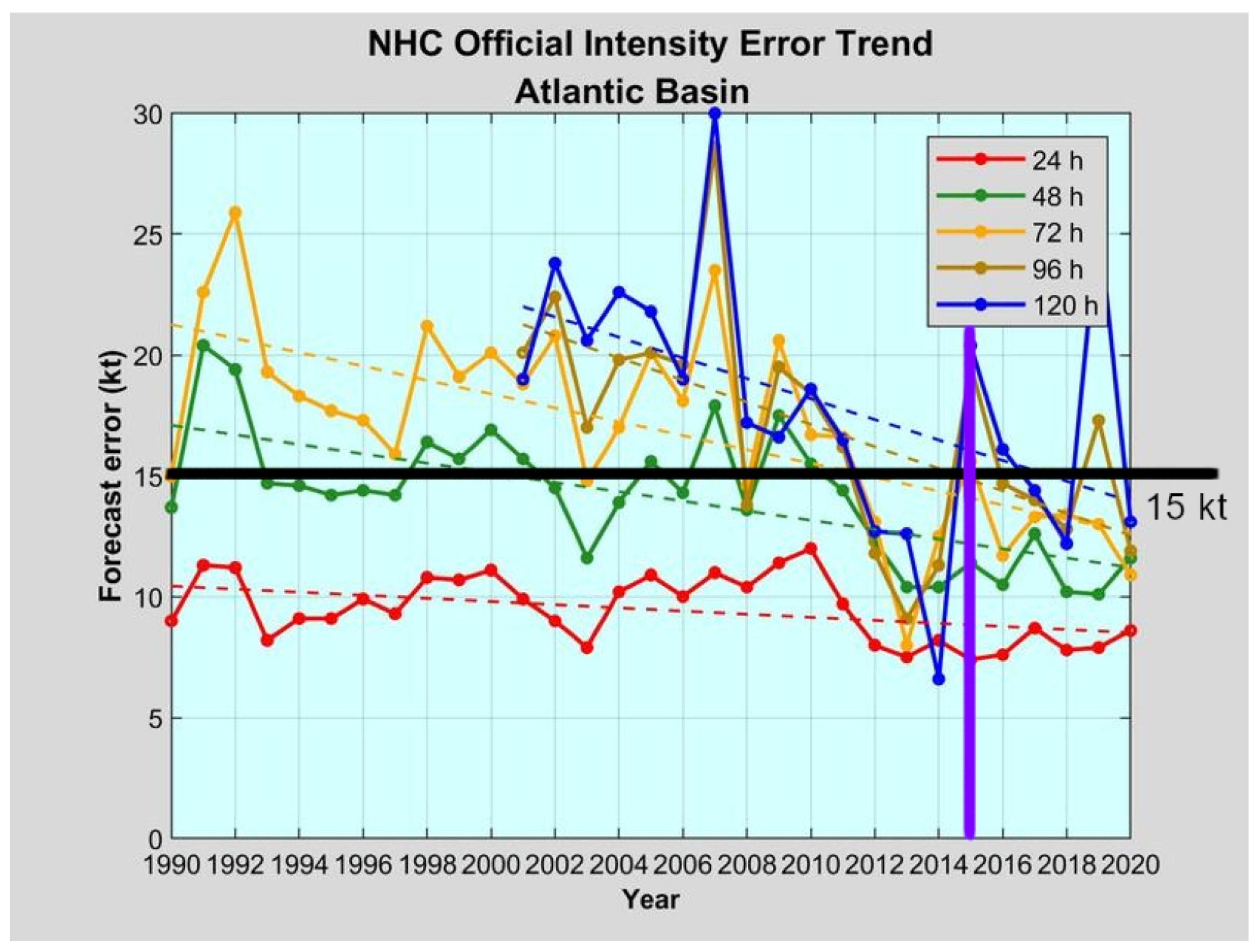
1.1. Motivation
1.2. Rapid Intensification
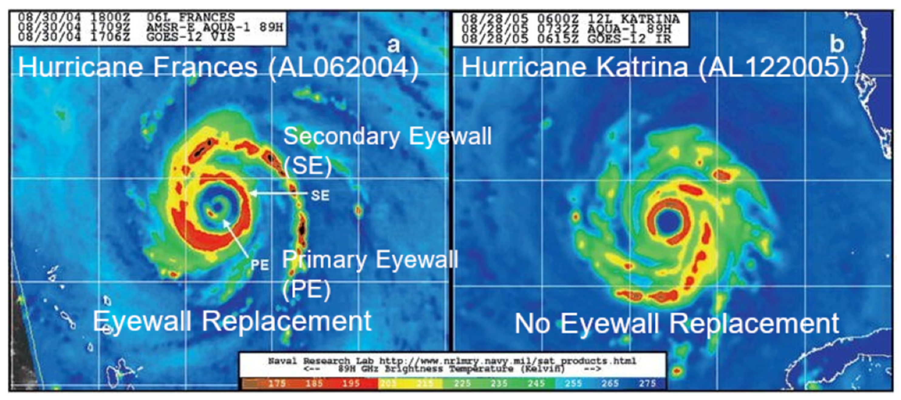
1.3. Eyewall Replacement Cycles
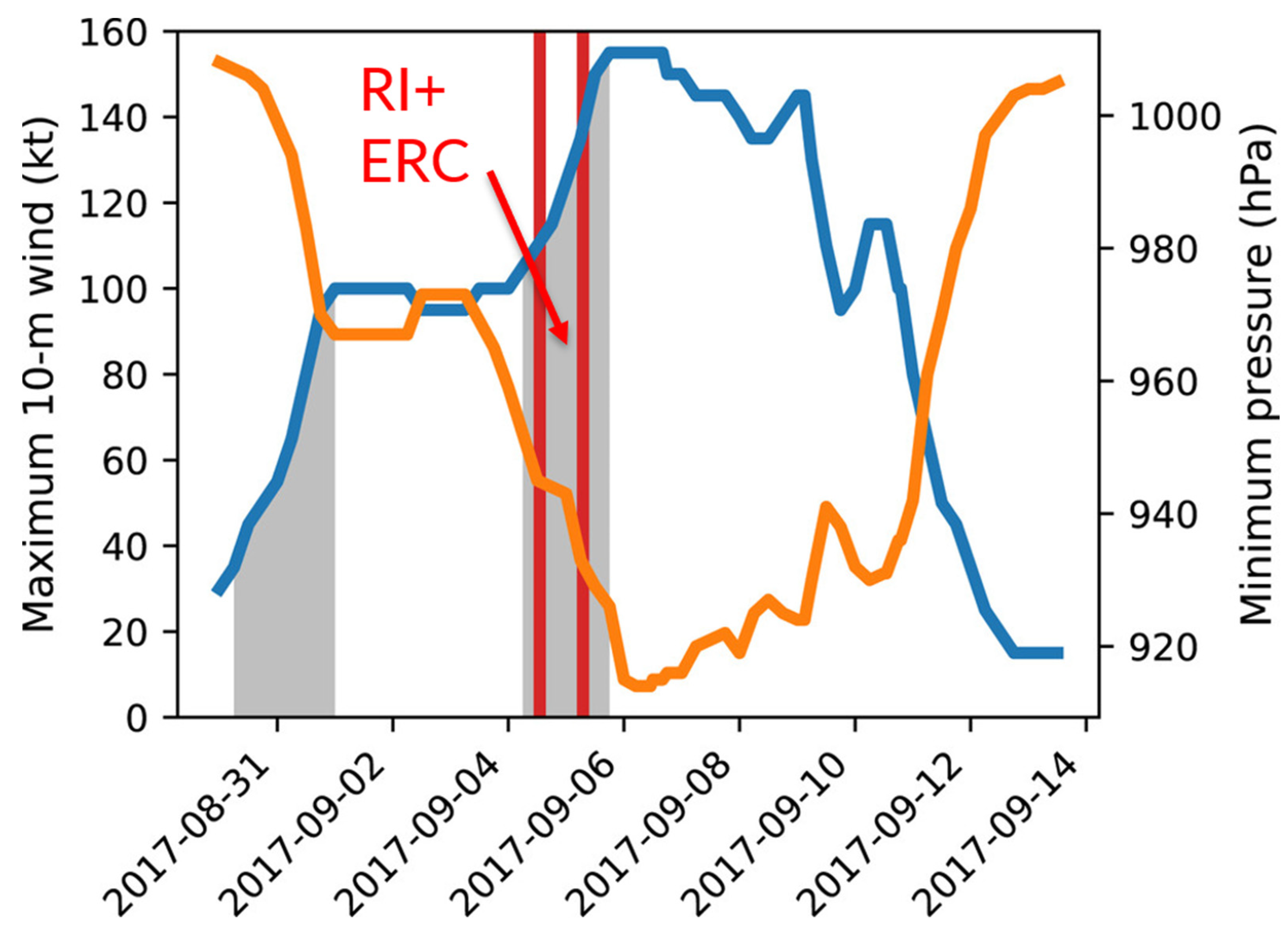
1.4. Paired RI/ERC Events
2. Data and Methods
2.1. Tropical Cyclone Data
2.2. Methodology and Statistical Variables Selected for Analysis
3. Results and Conclusions
3.1. RI-Only Events vs. Paired RI/ERC Events
3.2. ERC-Only Events vs. Paired RI/ERC Events
3.3. Conclusions and Future Work
Author Contributions
Funding
Data Availability Statement
Acknowledgments
Conflicts of Interest
References
- Fischer, M.S.; Rogers, R.F.; Reasor, P.D. The Rapid Intensification and Eyewall Replacement Cycles of Hurricane Irma (2017). Mon. Weather Rev. 2020, 148, 981–1004. [Google Scholar] [CrossRef]
- Willoughby, H.E.; Clos, J.A.; Shoreibah, M.G. Concentric Eye Walls, Secondary Wind Maxima, and The Evolution of the Hurricane Vortex. J. Atmos. Sci. 1982, 39, 395–411. [Google Scholar] [CrossRef]
- Kossin, J.P.; Sitkowski, M. An Objective Model for Identifying Secondary Eyewall Formation in Hurricanes. Mon. Weather Rev. 2009, 137, 876–892. [Google Scholar] [CrossRef]
- Sitkowski, M.; Kossin, J.P.; Rozoff, C.M. Intensity and Structure Changes during Hurricane Eyewall Replacement Cycles. Mon. Weather Rev. 2011, 139, 3829–3847. [Google Scholar] [CrossRef]
- Zhou, X.; Wang, B. Mechanism of Concentric Eyewall Replacement Cycles and Associated Energy Change. J. Atmos. Sci. 2011, 68, 972–988. [Google Scholar] [CrossRef]
- Kossin, J.P.; Sitkowski, M. Predicting Hurricane Intensity and Structure Changes Associated with Eyewall Replacement Cycles. Weather Forecast. 2012, 27, 484–488. [Google Scholar] [CrossRef]
- National Oceanic and Atmospheric Administration. Glossary of NHC Terms. National Hurricane Center. 2021. Available online: https://www.nhc.noaa.gov/aboutgloss.shtml#:~:text=Rapid%20Intensification%3A,in%20a%2024%2Dh%20period (accessed on 1 October 2021).
- National Oceanic and Atmospheric Administration. ‘Average’ Atlantic Hurricane Season to Reflect More Storms. 2020. Available online: https://www.noaa.gov/media-release/average-atlantic-hurricane-season-to-reflect-more-storms (accessed on 2 September 2021).
- Wang, C.; Wang, X.; Weisberg, R.H.; Black, M.L. Variability of Tropical Cyclone Rapid Intensification in the North Atlantic and Its Relationship with Climate Variations. 2017; 46p. Available online: https://repository.library.noaa.gov/view/noaa/20197/noaa_20197_DS1.pdf (accessed on 2 September 2021).
- Elsberry, R.L.; Lambert, T.D.B.; Boothe, M.A. Accuracy of Atlantic and Eastern North Pacific Tropical Cyclone Intensity Forecast Guidance. Weather Forecast. 2007, 22, 747–762. [Google Scholar] [CrossRef]
- Sampson, C.R.; Kaplan, J.; Knaff, J.A.; DeMaria, M.; Sisko, C.A. A Deterministic Rapid Intensification Aid. Weather Forecast. 2011, 26, 579–585. [Google Scholar] [CrossRef]
- Kaplan, J.; Rozoff, C.M.; DeMaria, M.; Sampson, C.R.; Kossin, J.P.; Velden, C.S.; Cione, J.J.; Dunion, J.P.; Knaff, J.A.; Zhang, J.A.; et al. 2015: Evaluating Environmental Impacts on Tropical Cyclone Rapid Intensification Predictability Utilizing Statistical Models. Weather Forecast. 2015, 30, 1374–1396. [Google Scholar] [CrossRef]
- Rozoff, C.M.; Velden, C.S.; Kaplan, J.; Kossin, J.P.; Wimmers, A.J. Improvements in the Probabilistic Prediction of Tropical Cyclone Rapid Intensification with Microwave Observations. Weather Forecast. 2015, 30, 1016–1038. [Google Scholar] [CrossRef]
- Su, H.; Wu, L.; Jiang, J.; Pai, R.; Liu, A.; Zhai, A.; Tavallai, P.; DeMaria, M. Applying Satellite Observations of Tropical Cyclone Internal Structures to Rapid Intensification Forecast With Machine Learning. Geophys. Res. Lett. 2020, 47, e2020GL089102. [Google Scholar] [CrossRef]
- Kaplan, J.; DeMaria, M.; Knaff, J.A. A Revised Tropical Cyclone Rapid Intensification Index for the Atlantic and Eastern North Pacific Basins. Weather Forecast. 2010, 25, 220–241. [Google Scholar] [CrossRef]
- DeMaria, M.; Sampson, C.R.; Knaff, J.A.; Musgrave, K.D. Is Tropical Cyclone Intensity Guidance Improving? Bull. Am. Meteorol. Soc. 2014, 95, 387–398. [Google Scholar] [CrossRef]
- National Oceanic and Atmospheric Administration. National Hurricane Center Forecast Verification. National Hurricane Center. 2021. Available online: https://www.nhc.noaa.gov/verification/verify5.shtml (accessed on 28 November 2021).
- National Oceanic and Atmospheric Administration. Saffir-Simpson Hurricane Wind Scale. National Hurricane Center. 2021. Available online: https://www.nhc.noaa.gov/aboutsshws.php (accessed on 28 November 2021).
- Hope, J.R.; Neumann, C.J. An Operational Technique For Relating The Movement of Existing Tropical Cyclones to Past Tracks. Mon. Weather Rev. 1970, 98, 925–933. [Google Scholar] [CrossRef]
- DeMaria, M.; Kaplan, J. A Statistical Hurricane Intensity Prediction Scheme (SHIPS) for the Atlantic Basin. Weather Forecast. 1994, 9, 209–220. [Google Scholar] [CrossRef]
- National Oceanic and Atmospheric Administration. NHC Track and Intensity Models. National Hurricane Center. 2021. Available online: https://www.nhc.noaa.gov/modelsummary.shtml (accessed on 30 November 2021).
- Kaplan, J.; DeMaria, M. Large-Scale Characteristics of Rapidly Intensifying Tropical Cyclones in the North Atlantic Basin. Weather Forecast. 2003, 18, 1093–1108. [Google Scholar] [CrossRef]
- Bosart, L.F.; Bracken, W.E.; Molinari, J.; Velden, C.S.; Black, P.G. Environmental Influences on the Rapid Intensification of Hurricane Opal (1995) over the Gulf of Mexico. Mon. Weather Rev. 2000, 128, 322–352. [Google Scholar] [CrossRef]
- Shay, L.K.; Goni, G.J.; Black, P.G. Effects of a Warm Oceanic Feature on Hurricane Opal. Mon. Weather Rev. 2000, 128, 1366–1383. [Google Scholar] [CrossRef]
- Rappin, E.D.; Morgan, M.C.; Tripoli, G.J. The Impact of Outflow Environment on Tropical Cyclone Intensification and Structure. J. Atmos. Sci. 2011, 68, 177–194. [Google Scholar] [CrossRef]
- Miyamoto, Y.; Takemi, T. A Triggering Mechanism for Rapid Intensification of Tropical Cyclones. J. Atmos. Sci. 2015, 72, 2666–2681. [Google Scholar] [CrossRef]
- Kossin, J.P.; Schubert, W.H. Mesovorticies, Polygonal Flow Patterns, and Rapid Pressure Falls in Hurricane-Like Vortices. J. Atmos. Sci. 2001, 58, 2196–2209. [Google Scholar] [CrossRef]
- Kieper, M.E.; Jiang, H. Predicting Tropical Cyclone Rapid Intensification using the 37 GHz Ring Pattern Identified from Passive Measurements. Geophys. Res. Lett. 2012, 39, L13804. [Google Scholar] [CrossRef]
- Irish, J.L.; Resio, R.T.; Ratcliff, J.J. The Influence of Storm Size on Hurricane Surge. J. Phys. Oceanogr. 2008, 38, 2003–2013. [Google Scholar] [CrossRef]
- Hawkins, J.; Helveston, M. Tropical Cyclone Multiple Eyewall Characteristics. In Proceedings of the 26th Conference on Hurricanes and Tropical Meteorology, Miami, FL, USA, 2 May 2004; American Meteorological Society: Boston, MA, USA, 2004. P1.7. Available online: https://ams.confex.com/ams/26HURR/techprogram/paper_76084.htm (accessed on 5 December 2021).
- Hawkins, J.; Helveston, M.; Lee, T.F.; Turk, F.J.; Richardson, K.; Sampson, C.; Kent, J.; Wade, R. Tropical Cyclone Multiple Eyewall Configurations. In Proceedings of the 27th Conference on Hurricanes and Tropical Meteorology, Miami, FL, USA, 23 April 2006; American Meteorological Society: Boston, MA, USA, 2006. 6B.1. Available online: https://ams.confex.com/ams/27Hurricanes/techprogram/paper_108864.htm (accessed on 5 December 2021).
- Holland, G.J. The Maximum Potential Intensity of Tropical Cyclones. J. Atmos. Sci. 1997, 54, 2519–2541. [Google Scholar] [CrossRef]
- Shimada, U.; Sawada, M.; Yamada, H. Doppler Radar Analysis of the Rapid Intensification of Typhoon Goni (2015) after Eyewall Replacement. J. Atmos. Sci. 2018, 75, 143–162. [Google Scholar] [CrossRef]
- Lee, W.-C.; Jou, B.J.-D.; Chang, P.-L.; Deng, S.-M. Tropical Cyclone Kinematic Structure Retrieved from Single-Doppler Observations. Part I: Interpretation of Doppler Velocity Patterns and the GBVTD Technique. Mon. Weather Rev. 1999, 127, 2419–2439. [Google Scholar] [CrossRef]
- Cangialosi, J.P.; Latto, A.S.; Berg, R. National Hurricane Center Tropical Cyclone Report, Hurricane Irma, 30 August–12 September 2017. 2021; 111p. Available online: https://www.nhc.noaa.gov/data/tcr/AL112017_Irma.pdf (accessed on 5 December 2021).
- Landsea, C.; Beven, J. The Revised Atlantic Hurricane Database (HURDAT2). National Hurricane Center. 2019. Available online: https://www.nhc.noaa.gov/data/hurdat/hurdat2-1851-2020-052921.txt (accessed on 5 December 2021).
- Cooperative Institute for Meteorological Satellite Studies. Morphed Integrated Microwave Imagery at CIMSS. 2021. Available online: http://tropic.ssec.wisc.edu/real-time/mimic-tc/archive/archive.html (accessed on 5 December 2021).
- Francis, A.S.; Strahl, B.R. Annual Tropical Cyclone Report. Joint Typhoon Warning Center. 2021. Available online: https://www.metoc.navy.mil/jtwc/products/atcr/2020atcr.pdf (accessed on 19 November 2023).
- Climate Prediction Center. Background Information: Eastern Pacific Hurricane Season. 2023. Available online: https://www.cpc.ncep.noaa.gov/products/Epac_hurr/Background.html (accessed on 19 November 2023).


| Steps | Event A | Event B | Event C | Event D |
|---|---|---|---|---|
| 1: >30 kt increase intensity since t = −24 h? | Yes | No | Yes | No |
| 2: >75% enclosure of PE by SE on microwave imagery at t = 0 h? | No | Yes | Yes | No |
| If yes to (1) and (2), did both happen within 24 h? | N/A | N/A | Yes | N/A |
| List to be added to | RI-Only | ERC-Only | Paired RI/ERC | Neither |
| Category (Units) | RI Only | Paired | t-Test (Unitless) | SD RI-Only | SD Paired |
|---|---|---|---|---|---|
| Number of TCs | 21 | 11 | N/A | N/A | N/A |
| Number of Events | 24 | 16 | N/A | N/A | N/A |
| Mean Intensification Duration (h) | 29.50 | 34.69 | 0.081 | 7.96 | 12.82 |
| Mean Intensification Rate (kt/24 h) | 37.87 | 38.31 | 0.444 | 8.32 | 10.57 |
| Mean Peak Intensity (kt) | 101.90 | 125.00 | 0.007 | 26.53 | 21.56 |
| Category (Units) | ERC Only | Paired | t-Test (Unitless) | SD ERC-Only | SD Paired |
|---|---|---|---|---|---|
| Number of TCs | 4 | 11 | N/A | N/A | N/A |
| Number of Events | 4 | 16 | N/A | N/A | N/A |
| Mean Weakening Phase Duration (h) | 19.31 | 16.64 | 0.242 | 6.20 | 6.89 |
| Mean Intensification Rate (kt/24 h) | 3.00 | 38.31 | 0.018 | 20.23 | 10.57 |
| Mean Peak Intensity (kt) | 127.50 | 125.00 | 0.437 | 26.61 | 21.56 |
Disclaimer/Publisher’s Note: The statements, opinions and data contained in all publications are solely those of the individual author(s) and contributor(s) and not of MDPI and/or the editor(s). MDPI and/or the editor(s) disclaim responsibility for any injury to people or property resulting from any ideas, methods, instructions or products referred to in the content. |
© 2023 by the authors. Licensee MDPI, Basel, Switzerland. This article is an open access article distributed under the terms and conditions of the Creative Commons Attribution (CC BY) license (https://creativecommons.org/licenses/by/4.0/).
Share and Cite
Currier, J.W., Jr.; Preston, A.D. The Pairing of Rapid Intensification Events and Eyewall Replacement Cycles in Tropical Cyclones in the Atlantic Basin from 2015 to 2020. Atmosphere 2024, 15, 53. https://doi.org/10.3390/atmos15010053
Currier JW Jr., Preston AD. The Pairing of Rapid Intensification Events and Eyewall Replacement Cycles in Tropical Cyclones in the Atlantic Basin from 2015 to 2020. Atmosphere. 2024; 15(1):53. https://doi.org/10.3390/atmos15010053
Chicago/Turabian StyleCurrier, John W., Jr., and Ari D. Preston. 2024. "The Pairing of Rapid Intensification Events and Eyewall Replacement Cycles in Tropical Cyclones in the Atlantic Basin from 2015 to 2020" Atmosphere 15, no. 1: 53. https://doi.org/10.3390/atmos15010053