Article

Quantifying the Impact of Urban Growth on Urban Surface Heat Islands in the Bangkok Metropolitan Region, Thailand

Center of Excellence in Urban Mobility Research and Innovation, Faculty of Architecture and Planning, Thammasat University, Pathumthani 12120, Thailand
*
Author to whom correspondence should be addressed.
Atmosphere 2024, 15(1), 100; https://doi.org/10.3390/atmos15010100
Submission received: 30 November 2023 / Revised: 31 December 2023 / Accepted: 9 January 2024 / Published: 12 January 2024
(This article belongs to the Special Issue Urban Heat Islands and Global Warming (2nd Edition))

Abstract

:
The urban built environment, comprising structures, roads, and various facilities, plays a key role in the formation of urban heat islands, which inflict considerable damage upon human society. This phenomenon is particularly pronounced in urban areas characterized by the rapid growth and concentration of populations, a global trend, notably exemplified in megacities such as Bangkok, Thailand. The global trend of urbanization has witnessed unprecedented growth in recent decades, with cities transforming into megametropolises that profoundly impact changes in urban temperature, specifically the urban heat island (UHI) phenomenon induced by the rapid growth of urban areas. Elevated urban concentrations lead to increased city density, contributing to higher temperatures within the urban environment compared to the surrounding areas. The evolving land-use surface has assumed heightened significance due to urban development, necessitating accelerated efforts to mitigate urban heat islands. This study aims to quantify the influence of urban growth on urban surface temperature in Bangkok and its surrounding areas. The inverse relationship between urban temperature and land surface temperature (LST), coupled with urban area density, was examined using Landsat 5 and 8 satellite imagery. The analysis revealed a positive correlation between higher temperatures and levels of urban growth. Areas characterized by high-rise structures and economic activities experienced the most pronounced impact of the heat island phenomenon. The city exhibited a notable correlation between high density and high temperatures (high–high), signifying that increased density contributes to elevated temperatures due to heat dissipation (significant correlation of R2 = 0.8582). Conversely, low-temperature, low-density cities (low–low) with a dispersed layout demonstrated effective cooling of the surrounding area, resulting in a significant correlation with lower local temperatures (R2 = 0.7404). These findings provide valuable insights to assist governments and related agencies in expediting planning and policy development aimed at reducing heat in urban areas and steering sustainable urban development.

1. Introduction

The global trend of urbanization is escalating, resulting in the conversion of natural surfaces into urban areas and the development of urban infrastructure [1]. This phenomenon is further intensified by the migration of populations from rural to urban areas, thereby contributing to the degradation of the urban thermal environment. Consequently, heat islands manifest on urban surfaces, representing a prevalent occurrence in urban climates where the temperature at the city center exceeds that of the surrounding environment [2]. Globally, there are widespread reports of elevated urban temperatures, a consequence attributed to the swift pace of urbanization and the impacts of global warming. In Thailand, the primary urban areas encompass not only the city of Bangkok itself but also five other metropolitan provinces: Samut Prakan, Pathum Thani, Samut Sakhon, Nakhon Pathom, and Nonthaburi. Collectively, these areas span an extensive region of 7761.66 square kilometers [3]. Referred to as the Metropolis, this region serves as the economic epicenter where various activities, facilities, and services converge. The Metropolis has witnessed the interplay of agglomeration economies, resulting in the amalgamation of economic and social elements. However, this phenomenon has resulted in congestion within the primate city and has triggered a decentralized suburbanization process [3,4]. Simultaneously, rapid urbanization has catalyzed diverse developments that has expanded urban areas into the surrounding provinces. This expansion has been accompanied by heightened investments in land transportation, with a particular emphasis on enhancing connectivity with the city center through highway and motorway networks rather than prioritizing public transportation [4,5]. The concentration of road networks has exerted a significant influence on land-use patterns, contributing to the sprawl phenomenon and underlining vulnerabilities in urban–rural interface areas [4,5,6]. The relentless pace of urbanization has continually pressured local resources, necessitating an inclusive and resilient approach that integrates urban, periurban, and rural areas. This approach is framed within the context of “Urban Climate”, emphasizing the imperative for comprehensive consideration in addressing the challenges posed by the dynamic urban landscape. Challenges associated with climate change are intertwined with increasing temperatures, compelling the application of quantification techniques to provide decision makers with practical tools for effective urban planning [7]. The expansion of urban areas contributes to climate change by altering the relationship between surface albedo and the thermal characteristics of land-use–land-cover (LULC) conditions in urban environments, leading to the emergence of urban heat islands (UHIs) [8]. A UHI is a phenomenon in which the temperature in a metropolitan area significantly exceeds that of the surrounding regions, primarily attributable to changes in land surfaces induced by urban development [9].
The primary causes of UHIs are materials that generate heat and energy consumption in buildings, both contributing to elevated temperatures within the city. The adverse impacts of UHIs can be mitigated through various strategies, one of which involves augmenting urban green spaces, including the incorporation of green areas in public spaces [8,9]. In addressing this challenge, it is imperative to acknowledge the undeniable efficacy of local climate data in quantifying the magnitude of the urban heat island (UHI). Such data hold significance as they provide crucial information for comprehending temporal and spatial variables, ultimately supporting national policies in the realm of urban climate affairs, as illustrated in Table 1. Presently, there are limited insights into the potential applications of climate data, hindering informed decision making and suggesting the need for a comprehensive urban validation measurement of the results. Furthermore, contemporary research emphasizes the necessity of examining temperature records over multiple years rather than solely focusing on investigations of heightened urban temperature events in individual areas [10]. There is a growing acknowledgment of the significance of diverse urban clusters. Each city is distinguished by its unique natural environments and features of the built environment, making such approaches essential for unveiling responses to the interplay between urbanization, urban context, and rising temperatures [10,11]. The task at hand remains intricate and varies across diverse contexts, presenting a gap in progress, particularly in the development of adaptation strategies at the local level. On the contrary, current weather conditions are in a state of continual flux, and this trend is expected to persist and intensify over the next 20–30 years [12]. Undeniably, climate change, stemming from ongoing and escalating global warming, has emerged as a pressing global concern, affecting regions worldwide, including Thailand. This transformative context significantly influences the trajectory of urban development [13]. Moreover, Bangkok and its surrounding areas represent a sprawling metropolis characterized by the highest building and population density in the country. Notably, the predominant developmental focus is on infrastructure projects [14].
The fostering of foreign investment and economic growth, prioritized over the well-being of the local population, has spurred the expansion of densely populated cities, prompting shifts in land use. Consequently, it becomes both necessary and imperative to ready the city to confront the challenges posed by climate change. It is crucial to provide the city with a developmental framework that aligns with its unique circumstances and offers pertinent solutions. Addressing the imperative of lowering urban temperatures requires the identification of effective mitigation strategies. This research focuses on the assessment of changes in urban areas and land surface temperature (LST) through the analysis of satellite imagery. The quantification approach employed in this study aims to investigate the association between urban temperature and urbanization for the years 2000, 2010, and 2020. Additionally, the impact of urban growth is assessed through the examination of urban density, vegetation index (NDVI), and supplementary urban data pertaining to land surface temperature and urbanization. Despite ongoing initiatives to augment green spaces within the city, there is a lack of appropriate measures for fostering sustainable urban environmental development. Leveraging satellite data for operational purposes emerges as a potent tool for monitoring urban climate dynamics, facilitating informed planning activities in association with climate change mitigation and adaptation in urban areas [10,11]. This can be discerned through the observable decrease in urban green space, corresponding to an increase in urban area and a concomitant rise in land surface temperature.

2. Materials and Methods

2.1. Study Area

The Bangkok Metropolitan Region (BMR) is situated in the central plain area of Thailand, within the lower central region adjacent to the Gulf of Thailand. Geographically, it spans from approximately latitude 13 degrees 25 min in the north (Philippa) to latitude 14 degrees 11 min 40 s in the north (Philippa), and from longitude 99 degrees 48 min 30 s in the east (Philippa) to longitude 100 degrees 56 min 40 s in the east. Comprising six provinces (Bangkok, Nonthaburi, Pathum Thani, Nakhon Pathom, Samut Sakhon, and Samut Prakan), the BMR covers an area of approximately 7761.66 square kilometers, representing about 8.39% of the central region. Additionally, it constitutes around 1.52% of Thailand’s total land area, and its administrative boundaries are classified into two types: regional government and local government [22]. The predominant topography of the Bangkok Metropolitan Region is characterized by a river basin sited in the lower central plain of Thailand, encompassing a floodplain that is strategically located around significant rivers in the region. This lowland area is distinguished by dense and extensive sediment deposition, making it one of the most fertile regions in Thailand. Consequently, it is well suited for the cultivation of rice, field crops, and various plant varieties. The ground level exhibits a relatively flat terrain with a gentle slope ranging from approximately 1 to 2 degrees [23]. The average elevation of the ground hovers around 0–10 m above mean sea level, as depicted in Figure 1.
In the Bangkok Metropolitan Region (BMR), a megacity undergoing rapid urbanization, the area ranging from urban to suburban experiences significant transformation. The urban core, characterized by high density and extensive development, gives way to a transitional zone with a mix of urban and suburban features. As rapid urbanization progresses, suburban areas expand, marked by residential development, commercial centers, and increasing infrastructure to accommodate a growing population. Infrastructure development plays a vital role, determining the efficiency of the transition from urban to suburban zones. Land-use changes, driven by population migration from rural areas, result in the conversion of agricultural land into residential and commercial spaces. This dynamic process creates economic disparities between the urban core and suburban areas, with the former experiencing higher economic activity and job opportunities. To further understand the influencing factors contributing to the temperature variations in this urban–suburban continuum, a hypothesis requiring examination would involve investigating how specific urban planning strategies, green space distribution, and infrastructure development impact temperature differentials within the urban-to-suburban gradient.

2.2. Data

Landsat 5 and 8 satellite images were utilized to analyze changes in urban areas and urban temperatures within the Bangkok Metropolitan Region (BMR). Detailed images from Landsat satellites are presented in Table 2. The selection of satellite images involved choosing three cloud-free images (<10%) during the winter season to minimize analytical aberrations. These images were sourced from the Geo-Informatics and Space Technology Development Agency (public organization) and the website of the US Geological Survey (USGS) [24].

2.3. Data Analysis

The application of geospatial technology in studying heat island phenomena involves the use of remote sensing (RS). Satellite data are employed to analyze key parameters such as land surface temperature (LST), urban area, and vegetation index (NDVI). The data utilized for investigating heat island phenomena are elaborated upon as follows [25]:
  • The normalized difference vegetation index (NDVI) is a widely used metric in remote sensing and environmental studies to assess the health and density of vegetation cover. It is particularly valuable in conjunction with the analysis of land surface temperature (LST). NDVI is derived from satellite or aerial imagery and is calculated using the following formula:
    N D V I = N I R R E D N I R + R E D
    where NIR (band 4 and band 5) is the reflection value (reflectance) of the near-infrared range, and Red (band 4) is the reflectance of the red-wave range.
  • Satellite data were utilized for the analysis of surface temperature, with the 6th wavelength (band 6) specifically employed for this purpose. The satellite image was measured using the thermal infrared wavelength (band 6) at a wavelength of 11.475 µm. The analysis involved five steps, as outlined below:
    -
    Determination of TOA (top of atmospheric) spectral radiance is exhibited as shown in Equation (2):
    L(λ) = ML ∗ Qcal + AL
    where:
    Lλ = TOA spectral radiance (Watts/(m2 ∗ sr ∗ μm));
    ML = band-specific multiplicative rescaling factor from the metadata (RADIANCE_MULT_BAND_10);
    AL = band-specific additive rescaling factor from the metadata (RADIANCE_ADD_BAND_10).
    Qcal = quantized and calibrated standard product pixel values (DN).
    -
    Brightness temperature (BT):
    T = K 2 I n K 1 L λ + 1 273.15
    where:
    T = top of atmosphere brightness temperature (K);
    Lλ = TOA spectral radiance (Watts/(m2 ∗ sr ∗ μm));
    K1 = band-specific thermal conversion constant from the metadata (K1_CONSTANT_BAND_10);
    K2 = band-specific thermal conversion constant from the metadata (K2_CONSTANT_BAND_10).
    -
    Proportion of vegetation (Pv):
    Pv = Square (NDVI − NDVImin/NDVImax − NDVImin)
    -
    Land surface emissivity (LSE):
    LSE = 0.004 ∗ Pv + 0.986
    -
    Land surface temperature (LST):
    LST = BT/1 + w ∗ (BT/p) ∗ Ln (LSE)
    where:
    BT = satellite temperature;
    LSE = land surface emissivity;
    W = wavelength of emitted radiance (11.5 μm);
    P = h ∗ c/s (1.438 × 10⁻² mK);
    h = Planck’s constant (6.626 × 10⁻³⁴ Js);
    s = Boltzmann constant (1.38 × 10⁻²³ J/K);
    c = velocity of light (2.998 × 10⁸ m/s);
    p = 14,380.
  • The assessment of built-up area expansion or urban growth analysis was conducted for the years 2000, 2010, and 2020 within the Bangkok Metropolitan Region utilizing Landsat satellite imagery with a resolution of 30 m. The classification method employed for distinguishing built-up and non-built-up areas involved unsupervised classification. Additionally, analysis was performed using the normalized difference built-up index (NDBI), which serves as an indicator of the relationship between urban surface temperature and land-use type or coverage. This investigation is based on the evaluation of satellite-detected data, considering the wave reflection values from the density of constructed objects during both the day and night, along with the corresponding temperatures for each period, as expressed in Equation (7):
    NDBI = S W I R N I R S W I R + N I R
    where:
    NDBI = building index;
    NIR = short-wave infrared;
    SWIR = near-infrared infrared.
The association between urban areas and land surface temperature was determined using a regression analysis model which presents a statistical method of exploring the relationship of variables with known values, referred to as independent variation. The symbol x is commonly employed to estimate the value of another variable known as the dependent variable, denoted by the symbol y, in the examination of the relationship between variables. The coefficient value helps identify the independent and dependent variables. The relationship between the two variables can take various forms, such as a straight line or curve, and the analysis assesses the reliability of this relationship. The sequence of analysis steps is illustrated in Figure 2.

3. Results

3.1. Urban Growth

Landsat 5 and 8 satellite imagery were employed for urban analysis to examine urban area expansion in 2000, 2010, and 2020, as depicted in Figure 3.
The results of the analysis are presented in Table 3. Landsat 5 and 8 satellite images were utilized for classifying urban areas, green spaces, and other regions (such as water bodies and miscellaneous land) during the years 2000, 2010, and 2020. The maximum likelihood supervised method, widely employed for Landsat image classification, was applied. The findings indicate a consistent increase in urban areas annually, particularly in the metropolitan region. In 2000, the urban area covered 1151.41 sq. km; by 2010, it expanded to 1312.98 sq. km and further increased to 1433.20 sq. km in 2020. Conversely, the growth in the Bangkok area was comparatively less. As urban centers experienced higher density between 2010 and 2020, a notable trend was observed where more individuals sought suburban housing, as evidenced in areas like Pathum Thani Province and Nonthaburi. From Figure 3, the progression of urban area values across the three years of analysis is evident. In 2000, the urban area represented a total urban density of 24.45 percent, and this density consistently increased in 2010 (33.48 percent) and 2020 (42.07 percent). The urban areas are categorized into three levels: high, medium, and low. High-density areas, constituting more than 75 percent, are classified as areas with very high density, accounting for 40 percent of the total urban area. Areas with moderate density, ranging from 75 to 50 percent, are designated as moderate urban areas, covering 16 percent of the total area. Finally, areas with a density of less than 50 percent are classified as low-density areas.
The findings of the determination indicate that the Bangkok Metropolitan Region has undergone rapid urban development spanning 40–50 years, extending from the initiation of the First National Economic and Social Development Plan to the present day. It has evolved into a major administrative, economic, and employment hub, serving as a focal point for regional business, trade, and services. Consequently, population migration towards employment opportunities has fueled the substantial growth of Bangkok, surpassing that of surrounding cities and other provinces in Thailand. Historically, development policy plans for Bangkok and its environs sought to manage the city’s expansion, diversify job concentrations, promote public services, address flooding issues, and distribute economic growth across urban areas in the metropolitan region. Despite these efforts, congestion persists in both inner and middle-class cities. This study assesses and presents the urban area density growth from 2000 to 2020, as illustrated in Figure 4.
Based on the analysis results, Table 4 presents a ranking of urban areas according to the mean urban area values over the three years (2000, 2010, and 2020). The analysis reveals a discernible trend of urban growth radiating from the central Bangkok area towards the periphery, encompassing provinces such as Pathum Thani and Nonthaburi. This analysis employed the normalized difference built-up index (NDBI) and categorized areas into high-, medium-, and low-urban-density groups by analyzing the mean values across the three-year period and conducting grouping analysis. The findings indicate that areas with high urban density were led by Bangkok at 53.87%, followed by Nonthaburi at 25.61% and Pathum Thani at 10.71%. Conversely, areas with lower urban density were observed in Nakhon Pathom province at 34.99% and Pathum Thani at 18.42%. Therefore, the areas characterized by low urban density have potential for future development, supporting the continued expansion of urban areas.
Figure 4 illustrates that those areas experiencing growth in both urban density and urbanization over the years 2000, 2010, and 2020 are primarily concentrated in the city center, attributable to the formation and expansion of urban agglomerations. The determination results indicate that areas characterized by significant urban growth constitute approximately 40 percent. In contrast, regions with lower density comprise about 16 percent, predominantly situated near the periphery of Bangkok. The areas with the least urban density, constituting 44 percent, signify the presence of urban sprawl and the concentration of employment opportunities in outlying areas, encompassing both industrial and economic activities. This phenomenon arises from the strategic advantages of job availability and transportation convenience along highways, contributing to extended distances for industrial distribution, infrastructure development, and the establishment of regional markets.

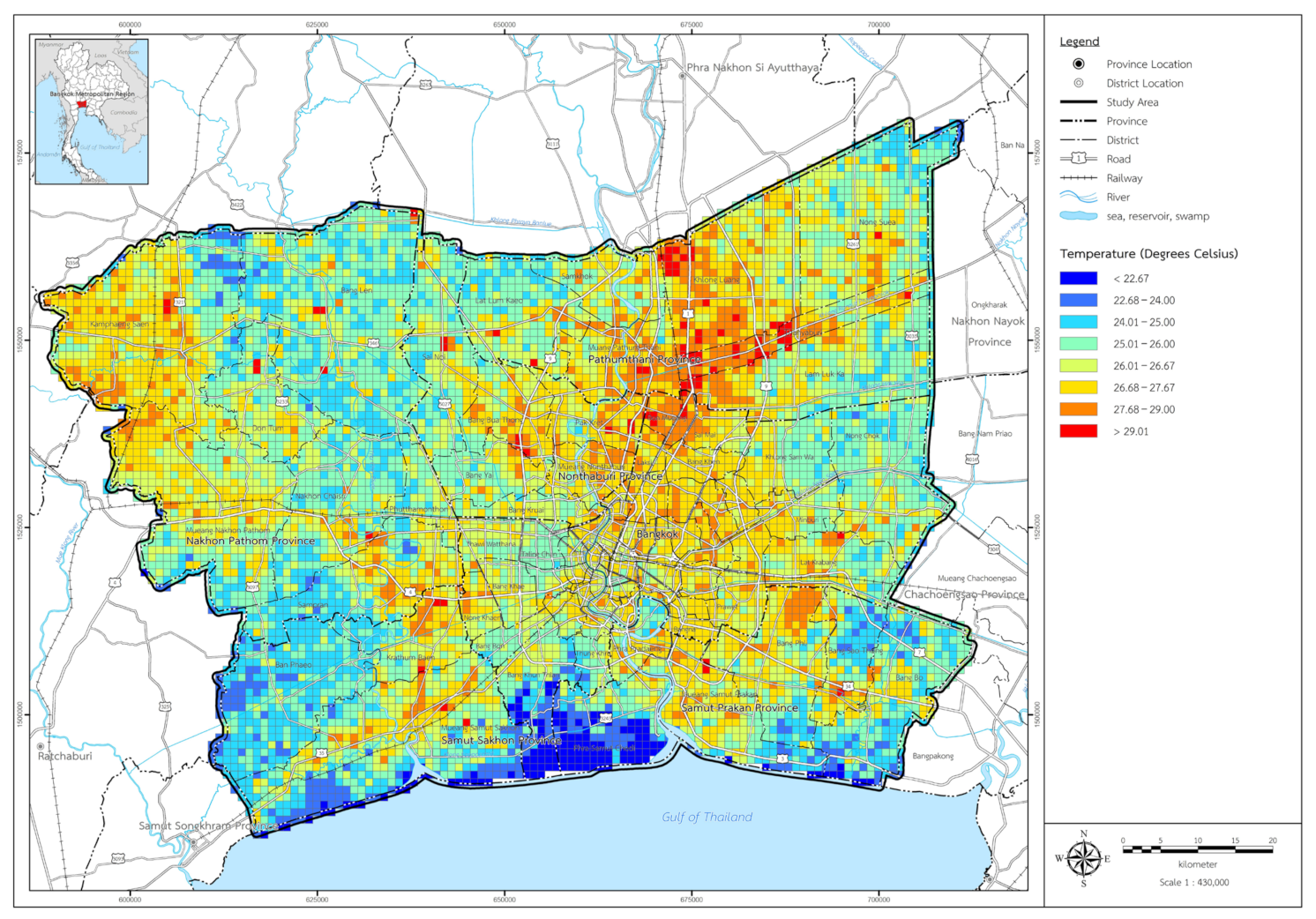
3.2. Land Surface Temperature (LST)

The land surface temperature (LST) in Bangkok can be derived by calculating mathematical values from satellite image data. The analysis reveals that in 2000, the lowest recorded surface temperature was 11 °C, while the highest was 30 °C, with an average surface temperature of 24.72 °C. In 2010, the lowest surface temperature measured was 13 °C, with the highest reaching 32 °C and an average surface temperature of 26.88 °C. Finally, in 2020, the lowest surface temperature recorded was 15 °C, the highest was 33 °C, and the mean surface temperature was 0.022 °C (see Figure 5).
The aforementioned data indicate a discernible increase in both average and maximum surface temperatures, even with minor variations (refer to Table 5 and Table 6). The findings emphasize the annual escalation of surface temperatures in Bangkok, especially within urban areas encompassing buildings and the building type index. These observations align with previous research that examined the heat island phenomenon in Bangkok through a comprehensive survey [13]. The outcomes of earlier investigations utilizing long-term thermal infrared data spanning 1994, 2000, and 2009 elucidated a robust correlation between elevated surface temperatures and environmental factors, particularly in areas facing significant impacts. These areas exhibited a propensity for the intensification of the heat island effect within the city.
When analyzing the city’s average temperature across all three years, it becomes evident that areas experiencing high temperatures exceeding 30 degrees Celsius are concentrated in the urban zones (see Figure 6). These areas include Phra Nakhon District, Dusit District, Pathum Wan, Huai Khwang, and Rama 9. Regions with temperatures ranging between 25 and 30 degrees Celsius are situated adjacent to the city center, exemplified by areas like Bang Khen, Bang Bon, and Bang Na.
Conversely, areas with temperatures below 25 degrees Celsius are located in the outer perimeter, representing typologies of rural and agricultural spaces, green areas, and water resources in locations such as Bang Len, Nong Chok, and Bang Bo. The dense urbanization of Bangkok and its surrounding regions is characterized by structures enclosed with concrete walls or glass panels coated with heat-reflecting compounds, distancing them from the surrounding buildings. The prevalence of concrete and other hard surfaces contributes to elevated heat levels. At the same time, green spaces and urban trees play a vital role in mitigating the city’s temperature by absorbing heat, thereby counteracting a phenomenon known as the “Heat Island” or “Urban Heat Island”. This condition refers to situations where the temperature in specific urban areas surpasses that of the neighboring regions. Furthermore, as the urban area expands, there is a simultaneous reduction in green spaces and a correlation that contributes to the exacerbation of urban temperatures and pollution. From Table 7, the highest temperatures recorded in Bangkok during all three periods (2000, 2010, and 2020) were 30.23 degrees Celsius, 32.14 degrees Celsius, and 33.32 degrees Celsius, respectively. Following Bangkok, similar temperature trends were observed in Samut Prakan, Nonthaburi, and Pathum Thani provinces. When considering the density of the urban area, it is noteworthy that areas characterized by high temperatures were consistently associated with higher urban density within the city.

3.3. Relationship between Urban and Land Surface Temperature

In analyzing the distinct characteristics of urban areas and urban temperatures during the three periods (2000, 2010, and 2020), a significant relationship between urban areas and temperatures was observed (refer to Figure 7 and Figure 8 and Table 8), with statistical significance at the 0.05 level. The urban area, characterized by building density and spatial utilization (refer to Figure 9), exhibited a notable correlation with urban temperature. High temperatures were concentrated in the central area, covering 351.71 sq. km., while low-temperature regions (24.60–25.43) were associated with lower urban density in the outer areas, encompassing an expansive area of 2598.17 sq. km., with temperatures ranging from 24.6 degrees Celsius to 30.2 degrees Celsius.

4. Discussion

Through the analysis of the influence of urban growth on urban temperature changes in 2000, 2010, and 2020, this study utilized key indicators (urban area density and temperature levels) to establish their relationship and reclassify temperature increases into high, medium, and low categories (refer to Table 8). The correlation and temperature analysis at different levels revealed that there is a significant association between urban temperature and high levels of urbanization (refer to Figure 9), as evidenced by an R2 value exceeding 0.5. This analysis indicated that dense urbanization is linked to higher urban temperatures, leading to intensified heat island conditions (refer to Table 9). Such conditions are pervasive across areas with differing land covers, consistently demonstrating that urban surfaces experience higher temperatures than rural areas. This phenomenon arises because urban surfaces exhibit superior heat absorption during the day and release heat into the atmosphere more gradually during the night compared to rural surfaces.
In the analysis of the association between urban density and urban temperature, it was observed that higher city temperatures are associated with increased urban density. Furthermore, in the reliability analysis, all nine relationships revealed an R2 value exceeding 0.05, signifying a significant correlation between urban density and urban temperature.
However, variations in the degree of temperature difference concentration between urban and rural surfaces depend on the physical and biological characteristics of each city. For instance, cities characterized by high building density and a scarcity of trees will exhibit different urban temperatures compared to rural areas. As a result, the heat island conditions in each city are unique and contingent upon the specific physical and biological attributes of that city. Furthermore, the observed increase in temperatures within urban areas is a consequential outcome, as depicted in Figure 8. The analysis of changes in the urban landscape over the past two decades, illustrated in Figure 9, reveals a notable expansion of Bangkok and its surrounding areas. However, this growth is characterized by disorganized distribution and a lack of strategic planning to guide urban development. Nevertheless, with the implementation of suitable supporting policies, urbanization can unlock new opportunities and pose challenges that stimulate the creation of jobs and business prospects for local goods and services. Table 9 examines the correlation between urban areas and temperatures within the urban setting. By categorizing cities and their temperatures into three levels (high, medium, and low), it is evident that there is a significant relationship between high city concentrations and high temperatures, as indicated by R2 = 0.8582, with the analytical equation y = −0.0033x + 27.165. Similarly, the low concentration of the city corresponds to low temperatures, with a significant relationship represented by R2 = 0.7404 and the analytical equation y = −6 × 10−7x2 + 0.0012x + 24.768. Hence, it can be presumed that the density of urban areas and urbanization has a discernible impact on urban temperatures.

5. Conclusions

The intensity of global warming is on the rise, and there has been a significant promotion of city expansion worldwide. Despite stringent control measures and campaigns, there are observable increases in surface temperatures and a decrease in the balance of urban green space. Urbanization persists globally, leaving a profound impact on the environment and contributing to increased pollution across various sectors. This trend is accompanied by broader social and economic implications. Therefore, this article organizes the relationship between urban areas and urban temperature into nine categories, classifying them based on the impact of urbanization values and temperature levels in each area. There were three important findings, which can be summarized as follows: (1) High urban areas and high temperatures: In areas with high urban activity, temperatures are notably elevated. This indicates a significant difference that requires attention. Such areas necessitate measures to reduce urban temperatures, such as increasing green space and implementing vertical gardens. These areas are identified as cities with the greatest need for mitigation. (2) Urban areas with low to moderate temperatures: In areas with lower to moderate temperatures, there is room for city growth. City activities and infrastructure can be developed in tandem with the management of green space to prevent temperature increases. These areas are identified as cities that can be developed in conjunction with the management of urban green space. (3) Low-temperature urban areas: Areas with low temperatures indicate less density in urban development, with ample green spaces still present. Therefore, these areas are suitable for development, and measures can be implemented to create the highest quality use of space. This includes efforts to maintain and enhance the city’s temperature.
In summary, these findings highlight the diverse temperature profiles across urban areas and suggest tailored strategies for urban development and temperature management. High-temperature areas require immediate mitigation efforts, those with moderate temperatures present opportunities for balanced development, and low-temperature areas are suitable for strategic and high-quality space utilization. Based on a three-year study spanning 2000, 2010, and 2020, this paper establishes a statistically significant correlation between urban areas and changes in urban temperature (land surface temperature—LST). It was observed that the expansion of urban areas is associated with temperature rise, influencing the evolving patterns of urban development and impacting the urban environment. The analysis results further revealed that areas with higher vegetation values experienced a reduction in heat island conditions [11]. Additionally, over the past two decades, air temperature data was employed to examine their relationship with urban areas. The findings indicated a critical crisis level in Bangkok’s city center, and it can be extrapolated from experiences in other large cities that higher building density correlates with elevated air temperatures, contributing to various issues such as pollution problems and urban inequality among the impoverished, among other factors.
Therefore, city planners and administrators should adopt a balanced approach to urban development, giving due consideration to the creation and maintenance of green spaces, which function as urban oases capable of mitigating and adapting to the impacts of climate change [26,27]. An essential question that arises is how well equipped communities in the area are to handle these crises. The report extends climate science data to social dimensions, examining the level of awareness and preparedness within urbanized communities. It scrutinizes the readiness of government agencies in each district to respond effectively, encompassing planning, personnel, tools, budget, and organizational management efficiency and competence across various fields. This perspective aligns with international scientific hypotheses that draw empirical conclusions indicating that global warming is leading to more frequent and severe disasters [28]. Bangkok, especially in its current state, is confronted with a severe climate change crisis. Addressing climate change has become a global imperative, necessitating the formulation of mitigation policies and action plans that address the challenges to urban sustainability, particularly in the context of the rapid growth of urban environments [29]. A future study could supervise a comprehensive analysis of urban impacts stemming from the observed relationship between urban areas and rising temperatures. Recognizing the potential consequences on population lives and city life quality, the study would aim to identify and evaluate consistent policies and measures for effective problem solving. Key areas of focus include assessing the impact of elevated temperatures on public health and well-being, examining the resilience of urban infrastructure, investigating economic implications across various sectors, refining urban planning and design strategies, addressing social equity and vulnerabilities in marginalized communities, and scrutinizing existing policies for consistency and implementation effectiveness. Such a multifaceted approach will contribute to a deeper understanding of the complex interplay between urbanization and temperature rise, informing the development of sustainable and resilient urban environments in the face of ongoing climate change.

Author Contributions

Conceptualization, P.I.; methodology, P.I.; validation, P.I. and S.C.; formal analysis, P.I., S.C. and A.P.; investigation, S.C.; resources, P.I.; data curation, S.C.; writing—original draft preparation, P.I., S.C. and A.P.; writing—review and editing, P.I., S.C. and A.P.; visualization, S.C. and A.P.; supervision, P.I.; project administration, S.C.; funding acquisition, P.I. All authors have read and agreed to the published version of the manuscript.

Funding

This research received funding from the National Research Council of Thailand (NRCT) under project entitled "Integrating Health and Well-being in Sustainable Urban Development", Contract No. N42A650244.

Institutional Review Board Statement

Not applicable.

Informed Consent Statement

Not applicable.

Data Availability Statement

Publicly available datasets were analyzed in this study. This data can be found here: United States Geological Survey database (https://earthexplorer.usgs.gov/, accessed on 15 January 2023).

Acknowledgments

The authors gratefully acknowledge the support provided by a grant from the National Research Council of Thailand (NRCT) under the project entitled “Integrating Health and Well-being in Sustainable Urban Development”, contract no. N42A650244. This research was also conducted by the Center for Excellence in Urban Mobility Research and Innovation, Faculty of Architecture and Planning, Thammasat University, Pathumthani, Thailand.

Conflicts of Interest

The authors declare no conflicts of interest.

References

  1. Li, K.; Che, Y.; Jiang, J. Grading surface urban heat island and investigating factor weight based on interpretable deep learning model across global cities. Environ. Int. 2023, 180, 108–196. [Google Scholar] [CrossRef]
  2. Shen, P.; Zhao, S.; Ma, Y.; Liu, S. Urbanization-induced Earth’s surface energy alteration and warming: A global spatiotemporal analysis. Remote Sens. Environ. 2023, 284, 113–361. [Google Scholar] [CrossRef]
  3. Lin, J.; Wei, K.; Guan, Z. Exploring the connection between morphological characteristic of built-up areas and surface heat islands based on MSPA. Urban Clim. 2024, 53, 101–764. [Google Scholar] [CrossRef]
  4. Sun, R.; Lü, Y.; Yang, X.; Chen, L. Understanding the variability of urban heat islands from local background climate and urbanization. J. Clean. Prod. 2019, 208, 743–752. [Google Scholar] [CrossRef]
  5. Fitzpatrick-Lins, K. Comparison of sampling procedures and data analysis for a land-use and land cover map. Photogramm. Eng. Remote Sens. 1981, 47, 343–351. [Google Scholar]
  6. Araya, Y.H.; Cabral, P. Analysis and Modeling of Urban Land Cover Change in Setúbal and Sesimbra, Portugal. Remote Sens. 2010, 2, 1549–1563. [Google Scholar] [CrossRef]
  7. Bhatta, B. Analysis of urban growth pattern using remote sensing and GIS: A case study of Kolkata. India Int. J. Remote Sens. 2009, 30, 4733–4746. [Google Scholar] [CrossRef]
  8. Iamtrakul, P.; Padon, A.; Klaylee, J. Analysis of Urban Sprawl and Growth Pattern Using Geospatial Technologies in Megacity, Bangkok, Thailand. Geoinformatics and Data Analysis. Lect. Notes Data Eng. Commun. Technol. ICGDA 2021, 143, 109–123. [Google Scholar]
  9. Wangchongyu, P.; Rui, W.; Jin, D.; Weijun, G.; Zhengxi, F. Surface and canopy urban heat islands: Does urban morphology result in the spatiotemporal differences? Urban Clim. 2022, 42, 101136. [Google Scholar]
  10. Hamoodi, M.N.; Corner, R.; Dewan, A. Thermophysical behaviour of LULC surfaces and their effect on the urban thermal environment. J. Spat. Sci. 2019, 64, 111–130. [Google Scholar] [CrossRef]
  11. Srivanit, M.; Iamtrakul, P. Spatial Patterns of Greenspace Cool Islands and Their Relationship to Cooling Effectiveness in the Tropical City of Chiang Mai, Thailand, Environmental Monitoring and Assessment; Springer International Publishing: Berlin/Heidelberg, Germany, 2019; Volume 191, p. 530. [Google Scholar]
  12. Srivanit, M.; Hokao, K.; Iamtrakul, P. Classifying Thermal Climate Zones to Support Urban Environmental Planning and Management in the Bangkok Metropolitan Area. J. Archit. Plan. Res. Stud. (JARS) 2014, 11, 73–92. [Google Scholar]
  13. Iamtrakul, P.; Nusook, T.; Ubolchay, P. Impact of urban heat Island on daily life of people in Bangkok Metropolitan Region (BMR). J. Archit. Plan. Res. Stud. (JARS) 2014, 11, 53–72. [Google Scholar]
  14. Kotharkar, R.; Ramesh, A.; Bagade, A. Urban Heat Island studies in South Asia: A critical review. Urban Clim. 2018, 24, 1011–1026. [Google Scholar] [CrossRef]
  15. Debbage, N.; Shepherd, J.M. The urban heat island effect and city contiguity. Comput. Environ. Urban. Syst. 2015, 54, 181–194. [Google Scholar] [CrossRef]
  16. Liu, Y.; Li, Q.; Yang, L.; Mu, K.; Zhang, M.; Liu, J. Urban heat island effects of various urban morphologies under regional climate conditions. Sci. Total Environ. 2020, 743, 140589. [Google Scholar] [CrossRef]
  17. Cheval, S.; Popa, A.M.; Șandric, I.; Iojă, I.C. Exploratory Analysis of Cooling Effect of Urban Lakes on Land Surface Temperature in Bucharest (Romania) using Landsat imagery. Urban Clim. 2020, 34, 100696. [Google Scholar] [CrossRef]
  18. Lemus-Canovas, M.; Martin-Vide, J.; Moreno-Garcia, M.C.; Lopez-Bustins, J.A. Estimating Barcelona’s Metropolitan Daytime Hot and cold Poles Using Landsat-8 Land Surface Temperature. Sci. Total Environ. 2020, 699, 134307. [Google Scholar] [CrossRef]
  19. Logan, T.M.; Zaitchik, B.; Guikema, S.; Nisbet, A. Night and day: The Influence and Relative Importance of Urban Characteristics on Remotely Sensed Land Surface Temperature. Remote Sens. Environ. 2020, 247, 111861. [Google Scholar] [CrossRef]
  20. Firozjaei, M.K.; Fathololoumi, S.; Kiavarz, M.; Arsanjani, J.J.; Alavipanah, S.K. Modelling Surface Heat Island Intensity According to Differences of Biophysical Characteristics: A Case Study of Amol City. Iran. Ecol. Indic. 2020, 109, 105816. [Google Scholar] [CrossRef]
  21. Peng, T.; Jialin, L.; Luodan, C.; Ruiliang, P.; Zhongyi, W.; Haitao, Z.; Huilin, C.; Hongbo, G. Assessing spatiotemporal characteristics of urban heat islands from the perspective of an urban expansion and green infrastructure. Sustain. Cities Soc. 2021, 74, 103208. [Google Scholar]
  22. Liu, J.; Kuang, W.; Zhang, Z.; Xu, X.; Qin, Y.; Ning, J.; Zhou, W.; Zhang, S.; Li, R.; Yan, C.; et al. Spatiotemporal characteristics, patterns, and causes of land-use changes in China since the late 1980s. J. Geogr. Sci. 2014, 24, 195–210. [Google Scholar] [CrossRef]
  23. Liang, Z.; Wu, S.; Wang, Y.; Wei, F.; Huang, J.; Shen, J.; Li, S. The relationship between urban form and heat island intensity along the urban development gradients. Sci. Total Environ. 2020, 708, 135011. [Google Scholar] [CrossRef] [PubMed]
  24. The Geo-Informatics and Space Technology Development Agency. Satellite Images of the Landsat. 2021. Available online: https://earthexplorer.usgs.gov/ (accessed on 1 May 2023).
  25. Padon, A.; Iamtrakul, P.; Punson, B.; Klaylee, J. The Study on Association between Urban Green Space and Temperature Changes in Mega City. In Proceedings of the 2020 International Conference and Utility Exhibition on Energy, Environment and Climate Change (ICUE), Asian Institute of Technology, Pattaya City, Thailand, 20–22 October 2020. [Google Scholar]
  26. Iamtrakul, P.; Chayphong, S.; Klaylee, J. Measuring the Behavior and Preference for Energy Saving and Household Carbon Emission Reduction of Urban Residents in Bangkok and Its Vicinities, Thailand. Lowl. Technol. Int. 2020, 22, 239–248. [Google Scholar]
  27. Klaylee, J.; Padon, A.; Iamtrakul, P. Challenges of sustainable mobility: Context of car dependency, suburban areas in Thailand. Geogr. Pannonica 2023, 27, 145–158. [Google Scholar] [CrossRef]
  28. Padon, A.; Iamtrakul, P.; Chayut, T. The Study of Urbanization Effect on the Land Use Changes and Urban Infrastructures Development in the Metropolitan Areas, Thailand. IOP Conf. Ser. Earth Environ. Sci. 2021, 738, 012077. [Google Scholar] [CrossRef]
  29. Iamtrakul, P.; Padon, A.; Klaylee, J. Measuring Spatializing Inequalities of Transport Accessibility and Urban Development Patterns: Focus on Megacity Urbanization, Thailand. J. Reg. City Plan. 2022, 33, 345–366. [Google Scholar] [CrossRef]
Figure 1. The study area: Bangkok Metropolitan Region (BMR).
Atmosphere 15 00100 g001
Figure 2. Framework of study.
Atmosphere 15 00100 g002
Figure 3. Urban area in 2000, 2010, 2020.
Atmosphere 15 00100 g003
Figure 4. Urban growth in the Bangkok Metropolitan Region (for the years 2000, 2010, and 2020).
Atmosphere 15 00100 g004
Figure 5. Land surface temperature (LST) in 2000, 2010, and 2020.
Atmosphere 15 00100 g005
Figure 6. Land surface temperature in Bangkok Metropolitan Region by districts (for the years 2000, 2010, and 2020).
Atmosphere 15 00100 g006
Figure 7. Temperature distribution across districts in the Bangkok Metropolitan Region (for the years 2000, 2010, and 2020).
Atmosphere 15 00100 g007
Figure 8. Variation of temperatures in Bangkok Metropolitan Region by grid.
Atmosphere 15 00100 g008
Figure 9. Urban density in Bangkok Metropolitan Region by grid.
Atmosphere 15 00100 g009
Table 1. Examples of studies documenting various aspects of urban heat islands.
CountryNumber of
Cities
TopicSatellites UsedReference
United States of
America
50Impact of urban configuration on urban heat islands (UHIs) and identification of the optimal urban form for UHI mitigation.-[15]
China245Exploring the relationship between urban heat island (UHI) variability and the drivers of urbanization and background climate.-[4]
China25Examining the relationship between urban heat island (UHI) and meteorological conditions across five climate zones.-[16]
Romania12Conducting an exploratory analysis on the cooling impact of urban lakes on land surface temperature in Bucharest, Romania, using Landsat imagery.LANDSAT[17]
Spain6Estimation of daytime hot and cold poles in the Barcelona metropolitan area using Landsat-8 land surface temperature.LANDSAT, PCA, CA[18]
United States of
America
4Modeling the intensity of surface heat islands based on variations in biophysical characteristics in Amol City, Iran.LANDSAT, OBSERVATION[19]
Iran4Conducting an analysis to monitor and forecast heat island intensity using multitemporal image analysis and cellular automata–Markov chain modeling by focusing on Babol City, Iran.LANDSAT, WEATHER STATION, MODIS[20]
China10Evaluating the spatiotemporal characteristics of urban heat islands: an examination of urban expansion and green infrastructure perspectives.LANDSAT, MODIS[21]
Table 2. Landsat data (for the years 2000, 2010, and 2020).
Data TypeBandDate AcquiredSeasonPath/LowResolution
Landsat 5 TMTM20/01/2000Winter129/50 and 129/5160
Landsat 5 TMTM19/11/2010Winter60
Landsat 8OLI/TIRS19/12/2020Winter30
Table 3. Urban area changes (for the years 2000, 2010, 2020).
ProvinceUrban Area Changes (Square Kilometers)
200020102020
Urban Area%Green Area%Other Area%Urban Area %Green Area%Other Area%Urban Area %Green Area%Other Area%
Bangkok 408.5835.491053.7819.02113.4111.53514.2639.17561.1416.86334.9421.86570.8239.07641.2115.88247.5421.11
Nakhon Pathom108.069.391712.8330.91264.9826.94158.2912.061021.1130.7505.5233199.2513.641169.0628.97502.3842.83
Nonthaburi91.587.95509.599.235.993.66110.98.45349.3710.5113.237.39120.168.22377.469.3589.217.61
Pathum Thani141.5912.31331.0024.0245.794.65160.5512.23816.9324.56353.0423.05160.2310.971084.0426.86199.1816.98
Samut Prakan249.7521.69448.928.1280.7428.54249.0618.97182.295.48162.5610.61250.4517.14361.928.9786.487.37
Samut Sakhon151.8513.19484.818.75242.7224.68119.929.13395.7511.962.64.09160.2910.97402.239.9748.084.1
Total1151.411005540.93100.00983.63100.001312.981003326.591001531.891001433.201004035.921001172.87100
Table 4. Urban growth in the Bangkok Metropolitan Region.
ProvinceUrban Growth Level
High%Medium%Low%Total
Bangkok 718.0953.87358.5319.76493.1910.901569.81
Nakhon Pathom1.290.10549.2430.281583.1634.992133.70
Nonthaburi341.4125.6194.515.21200.304.43636.22
Pathum Thani142.7210.71538.2329.67833.5518.421514.50
Samut Prakan0.140.01271.5214.97676.3414.95948.00
Samut Sakhon129.329.702.110.12738.4216.32869.84
Total1332.98100.001814.14100.004524.97100.007672.08
Table 5. Factors considered in the analysis of land surface temperature in the Bangkok Metropolitan Region.
ProvinceFactor200020102020
Max.Min.Av.S.D.Max.Min.Av.S.D.Max.Min.Av.S.D.
Bangkok TOA10.878.459.590.1611.428.959.650.1813.1110.749.880.21
BT33.4217.7827.281.1835.3221.3126.921.5035.6423.2226.641.53
NDVI0.66−0.650.560.180.56−0.670.590.270.46−0.650.520.16
Pv0.990.110.820.110.990.080.890.100.990.060.820.12
LSE0.990.970.970.000.990.970.980.000.990.970.970.00
LST30.2320.1226.831.1232.1421.1430.021.1633.3225.4628.471.23
Nakhon PathomTOA9.527.958.810.1110.148.238.850.1010.878.719.590.20
BT32.2316.8824.251.3233.1520.0624.451.1933.4522.6125.261.54
NDVI0.86−0.740.500.210.84−0.700.520.280.78−0.650.530.18
Pv0.980.100.800.100.970.100.890.100.990.060.820.10
LSE0.980.950.650.000.970.600.980.000.990.960.950.05
LST25.6319.6625.530.8026.5320.6026.230.8831.6324.5426.530.92
NonthaburiTOA9.417.828.660.139.887.618.650.1310.658.449.360.22
BT32.3616.8625.631.0832.8420.4425.781.2433.4822.7425.631.58
NDVI0.72−0.680.480.180.68−0.650.450.210.62−0.580.400.23
Pv0.960.120.650.150.950.150.700.120.980.060.820.11
LSE0.960.720.820.110.950.700.850.130.980.080.840.09
LST28.6119.5225.211.2229.5020.5426.541.3131.5424.3227.611.36
Pathum ThaniTOA9.887.958.810.1110.329.158.760.1610.878.929.840.22
BT32.5617.2425.861.1832.8320.5625.841.2533.6222.8625.781.32
NDVI0.70−0.650.580.200.65−0.630.560.230.58−0.520.500.25
Pv0.990.100.820.150.980.080.890.130.960.500.960.18
LSE0.970.950.960.130.960.940.950.060.950.920.960.09
LST28.8220.5626.441.2429.5020.8626.521.3332.4524.8227.611.38
Samut PrakanTOA9.927.888.950.1510.449.568.430.1811.179.439.920.18
BT33.1217.4326.541.1934.2721.0926.401.2434.6523.1226.291.36
NDVI0.68−0.670.600.210.64−0.600.580.230.58−0.620.560.25
Pv0.980.090.920.120.970.100.900.130.960.150.890.16
LSE0.960.940.950.180.970.950.950.150.960.940.950.12
LST29.2220.6626.511.2630.2121.0427.211.4232.6224.6227.511.45
Samut SakhonTOA9.787.618.260.1210.088.489.630.1810.628.659.430.21
BT32.7817.1825.621.1835.2821.3126.921.5035.4523.6126.811.54
NDVI0.67−0.580.590.160.65−0.550.620.180.60−0.520.550.21
Pv0.990.100.900.150.980.080.920.100.990.060.820.12
LSE0.980.940.900.150.980.960.970.150.990.970.920.13
LST28.1420.2326.431.0627.5520.9226.851.1232.5524.6026.431.18
Note: TOA = top of atmospheric, BT = brightness temperature, NDVI = normalized difference vegetation index, Pv = proportion of vegetation, LSE = land surface emissivity, LST = land surface temperature.
Table 6. Land surface temperature (LST) in Bangkok Metropolitan Region (for the years 2000, 2010, and 2020).
Surface Temperature (LST)/YearYearly (Celsius)Change (Percent)
200020102020200020102020
Max. 303233+0.03−0.02+0.01
Min.111315+0.01−0.015+0.02
Average17.8418.4320.93−0.01−0.02−0.03
S.D.1.121.181.24−0.001−0.002−0.003
Table 7. Temperature distribution data (for the years 2000, 2010, and 2020) (degrees Celsius).
Province200020102020
Min.Max.AverageS.D.Min.Max.AverageS.D.Min.Max.AverageS.D.
Bangkok 20.1230.2326.831.1221.1432.1427.561.1625.4633.3228.471.23
Nakhon Pathom19.6625.6325.530.820.626.5326.230.8824.5431.6326.530.92
Nonthaburi19.5228.6125.211.2220.5429.526.541.3124.3231.5427.611.36
Pathum Thani20.5628.8226.441.2420.8629.526.521.3324.8232.4527.611.38
Samut Prakan20.6629.2226.511.2621.0430.2127.211.4224.6232.6227.511.45
Samut Sakhon20.2328.1426.431.0620.9227.5526.851.1224.632.5526.431.18
Table 8. Relationship between urban areas and land surface temperature (LST) in the Bangkok Metropolitan Region.
Urban
Level (sq. km)
Temperature Level (Degrees Celsius)
High
Area (Sq. km.)Grid%Max.Min.Av.S.D.Sig.
High924.83102061.8231.072627.140.850.000
Medium551.0462636.8325.972425.250.420.000
Low20.16231.3523.9720.6223.140.840.000
Total1496.031669100
Medium
High305.2857036.4330.382626.860.640.000
Medium502.4597259.9625.972425.190.460.000
Low30.27623.6123.9721.6223.230.640.001
Total8381604100
Low
High146.95101825.6429.232627.040.710.000
Medium379.22296766.1525.982425.130.530.000
Low47.067238.2123.9619.7122.930.850.001
Total573.234708100
Note: It was statistically significant at 0.05.
Table 9. Relationship between urban areas and land surface temperature (LST) in the Bangkok Metropolitan Region.
LevelUrban Area (Number of Grids)
HighMediumLow
Temperature (degrees Celsius)HighAtmosphere 15 00100 i001
677 grids
y = −0.0033x + 27.165
R2 = 0.8582
Atmosphere 15 00100 i002
680 grids
y = −0.0019x + 26.667
R2 = 0.1712
Atmosphere 15 00100 i003
380 grids
y = −0.0001x + 26.24
R2 = 0.0004
MediumAtmosphere 15 00100 i004
632 grids
y = −0.0036x + 27.177
R2 = 0.2727
Atmosphere 15 00100 i005
426 grids
y = −0.0005x + 25.746
R2 = 0.0079
Atmosphere 15 00100 i006
363 grids
y = −0.0044x + 26.222
R2 = 0.1567
LowAtmosphere 15 00100 i007
217 grids
y = −0.0139x + 26.172
R2 = 0.471
Atmosphere 15 00100 i008
1820 grids
y = −4 × 10−6x2 + 0.0052x + 24.831
R2 = 0.6129
Atmosphere 15 00100 i009
2795 grids
y = −6 × 10−7x2 + 0.0012x + 24.768
R2 = 0.7404
Disclaimer/Publisher’s Note: The statements, opinions and data contained in all publications are solely those of the individual author(s) and contributor(s) and not of MDPI and/or the editor(s). MDPI and/or the editor(s) disclaim responsibility for any injury to people or property resulting from any ideas, methods, instructions or products referred to in the content.

