Communication

Potential Distribution and Priority Conservation Areas of Pseudotsuga sinensis Forests under Climate Change in Guizhou Province, Southwesten China

1
Guizhou Province Key Laboratory of Ecological Protection and Restoration of Typical Plateau Wetlands, Guizhou University of Engineering Science, Guizhou 551700, China
2
Bijie Rocky Desertification and Prevention Management Center, Guizhou 551700, China
*
Author to whom correspondence should be addressed.
Atmosphere 2023, 14(3), 581; https://doi.org/10.3390/atmos14030581
Submission received: 25 December 2022 / Revised: 6 March 2023 / Accepted: 13 March 2023 / Published: 17 March 2023
(This article belongs to the Special Issue Vegetation and Climate Relationships (2nd Edition))

Abstract

:
Priority conservation areas are the key areas of biodiversity maintenance and ecosystem conservation. Based on a Maxent model, this study predicted the potential distribution of Pseudotsuga sinensis under the current climate and future climate change scenarios in Guizhou province, and then, assessed three kinds of priority conservation area under climate change. The results were as follows: (1) The AUC (Area Under the Curve) values showed excellent prediction accuracy of the model. (2) The areas of the potential habitats of P. sinensis forests under the current climate and future climate change scenarios were 22,062.85 km2 and 18,395.92 km2, respectively. As for their spatial distribution, the potential habitats of P. sinensis forests were distributed in the Bijie, Zunyi, Tongren, Liupanshui and Xingyi regions under the current climate, and in the Kaili region, in addition to the above-mentioned cities, under future climate change scenarios. (3) The total area of priority conservation areas under climate change was 25,350.26 km2. The area of the predicted sustainable potential habitats was 15,075.96 km2, of the vulnerable potential habitats was 7256.59 km2 and of the derivative potential habitats was 3017.71 km2.

1. Introduction

P. sinensis is a relic species of the Tertiary Period and an endangered species endemic to China [1]. With wide ecological adaptability, strong natural regeneration ability and low probability of pests and disease, P. sinensis is an important species of the water conservation forest in the subtropical mountainous area, and also an excellent artificial forest species [2].
Guizhou province is one of the main distribution area of natural P. sinensis forests in China. The P. sinensis community here plays an important role in warm temperate coniferous forests, and has become a crucial ecological barrier in mountainous karst areas. In Guizhou province, the majority of P. sinensis forests are distributed in nature reserves, and P. sinensis in these areas has a stable structure, rich biodiversity and high primitivity; meanwhile, the other P. sinensis forests are distributed in unprotected areas, and the P. sinensis forests of these areas have deteriorated gradually as a result of the inherent disadvantages of regeneration, and increasing human interference [3]. Conservation and restoration in the P. sinensis forests of unprotected areas have become extremely urgent.
Species distribution models (SDMs) use associations between climate and species occurrences to enable projections of potential alterations in habitats exposed to climate change, and have become a useful tool for evaluating the impact of climate change on the potential distribution of plants and vegetation [4,5]. Various SDMs have recently been developed and applied in studies on many topics, such as the impact of climate on species distribution [6,7,8,9], vegetation succession [10,11,12], biodiversity conservation [13] and alien species invasion [14], etc. Additionally, a few studies have applied these models to assessing the priority conservation areas of plants or vegetation under climate change. For instance, Nakao et al. [4]. assessed the priority of Fagus crenata in Japan based on a classification and regression tree model. Meanwhile, similar studies on endangered relict conifer species are seldomly reported.
The maximum entropy (Maxent) model is a prediction model based on the principle of maximum entropy. Based on the nonrandom relationship between environmental factors (such as climate, altitude, vegetation, etc.) and species distribution points, the distribution probability with the largest entropy is considered the optimal distribution under certain constraints, a spatial distribution model is constructed on a geographical scale and the potential distribution areas of species are predicted [15,16]. The Maxent algorithm’s output is a map of habitat suitability ranging from 0 to 1 per grid cell. Relying on its convenience, its use of presence-only species records and generally excellent predictive performance, the Maxent model has some advantages compared to other species distribution models for species habitat assessment [17,18,19].
In this study, a Maxent model with high accuracy was applied; then, the potential distribution of P. sinensis forests under the current climate and future climate change scenarios in Guizhou province were predicted, and three kinds of priority conservation area under climate change were established. We aimed to provide a reference for the conservation area division and management measure formulation of P. sinensis forests in accordance with future climate change.

2. Methods

2.1. Study Area

Guizhou province is located in southwestern China between 103°31′–109°30′ E and 24°30′–29°13′ N, with a total area of 176,167 km2 (Figure 1). The province has complex landforms, a typical climate and abundant biodiversity. In Guizhou Province, P. sinensis forests are mainly distributed in the Bijie (Weining county), Zunyi (Meitan county and Tongzi county) and Tongren regions (Songtao county and Dejiang county), among which the Bijie region (Weining county) occupies the largest area [3].

2.2. Data Sources

Distribution data for P. sinensis forests were obtained based on field investigation. The information on sampling points regarding longitude, latitude, elevation and terrain was record using a handheld GPS, separated by greater than 1 km, and then, exported to Microsoft Excel software and saved in CSV format, with a resolution of 30″ × 30″, though Arc GIS [20]. Finally, 107 effective sampling points of P. sinensis forest that covered various elevation ranges, administrative regions, and geological and geomorphologic types were extracted to build the prediction model.
A set of 19 bioclimatic factors, including current and future climate scenario (the RCP8.5 scenario for 2070–2099, the most extreme scenario) were downloaded from the WorldClim database (www.worldclim.org), and then, extracted through the administrative boundary of Guizhou province. In order to reduce the variables and avoid the impacts of collinearity on the prediction model, jackknife and Spearman (or Pearson) correlation analysis are frequently applied [13,17,21,22]. Nevertheless, as the statistical correlation relationship cannot completely explain the biological and ecological processes, some variables that have important biological and ecological significance in plants would be eliminated through these treatments. Therefore, all 19 bioclimatic variables were selected to construct the prediction model in this study.
The WGS84 projection coordinate system was used and exported in ASC format, preparing for the prediction model of P. sinensis forests.

2.3. Prediction Model

The Maxent algorithm was employed to predict the potential distribution of P. sinensis forests in Guizhou Province, owing to its operational convenience, excellent performance and superior accuracy [16,19]. A distribution probability diagram was exported after importing the distribution points and climate data, setting the parameters and operating the prediction model [23]. As for the parameter settings, 75% of the sampling points were extracted as training data, and the residual 25% were used as test data for model testing. The cross validation was selected as replicated types and run 10 times. The max number of background points was set at 200, to approach the value of the sampling points.
The AUC (Area Under the Curve) value, derived from the ROC (Receiver Operating Characteristic) analysis, was applied to evaluate the performance of the prediction model. The values of the AUC ranged from 0.5 to 1, with values above 0.9 indicating excellent accuracy of the prediction model. The AUC was considered the most popular measure of the accuracy for presence–absence predictions [24,25,26].

2.4. Potential Habitat Classification

Based on the actual distribution of P. sinensis forests, the areas where the predicted distribution probability was larger than 0.5 were defined as the potential habitats, and the others were defined as non-habitats. Then, the potential habitat distribution maps were drawn and their attribute tables were exported according to the classification results based on the current climate and future climate change scenarios. Spatial analysis was conducted to reveal their geographical distribution characteristics.

2.5. Priority Conservation Area Assessment under Climate Change

In this study, the priority conservation areas under climate change were composed of three parts: areas of common potential habitats under both the current climate and future climate change scenarios were defined as sustainable potential habitats, where potential habitats under the current climate that were predicted to become non-habitats under future climate change scenarios were defined as vulnerable potential habitats, and where non-habitats under the current climate that were predicted to become potential habitats under the future climate change scenarios were defined as derivative potential habitats [4].
Each type of priority conservation area had different significance in the protection and management of P. sinensis forests under climate change. Sustainable potential habitats need long-term protection under each climate condition. Vulnerable potential habitats require strategies and measures to mitigate the potential impacts of climate change on protected objects. Derivative potential habitats could be considered supplements for the future planning and adjustment of nature reserves.

3. Results

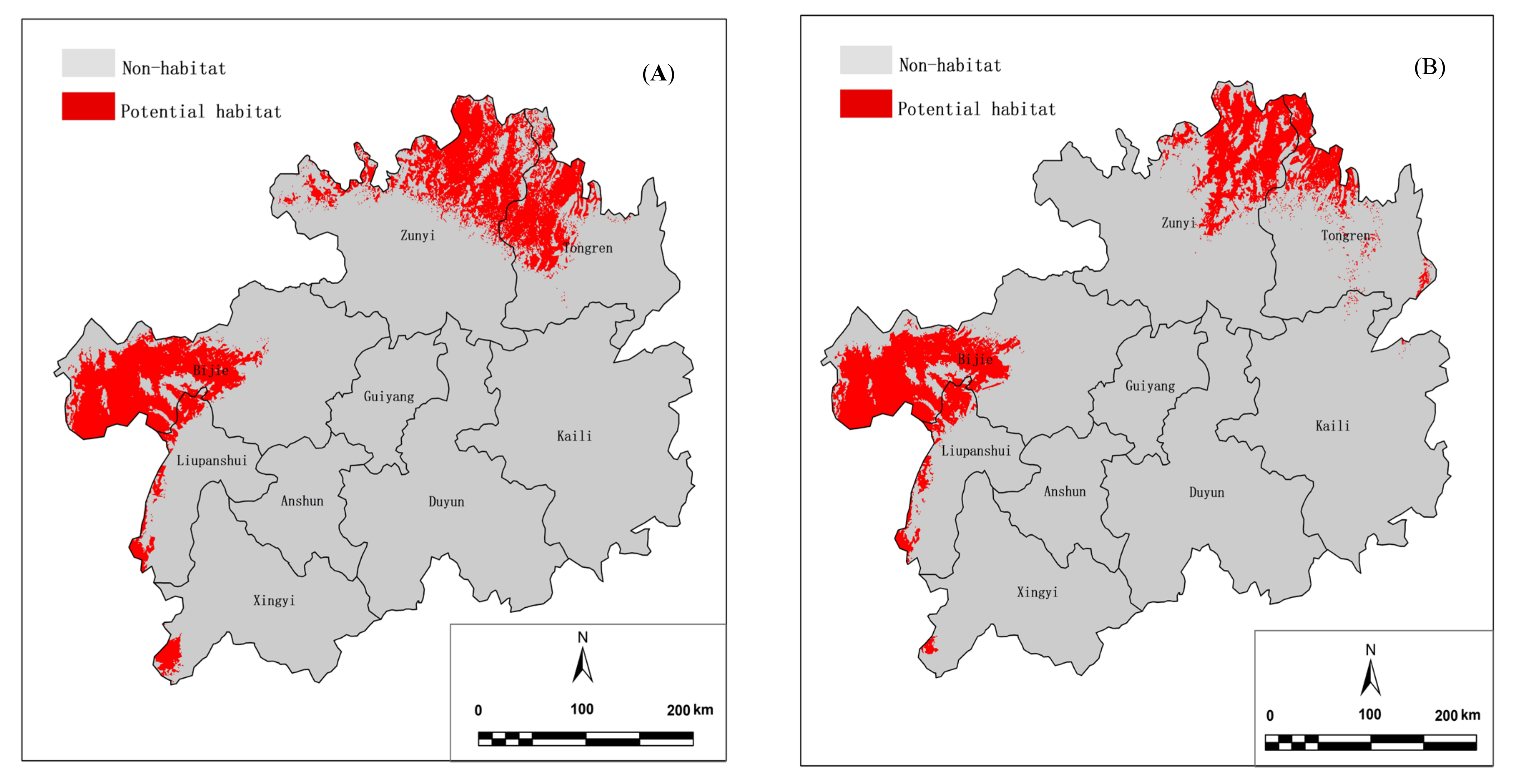
3.1. Prediction Accuracy, and Potential Habitats under Current Climate and Future Climate Change Scenarios

The AUC values of the training data and text data were 0.974 and 0.921, respectively, and showed excellent performance according to the evaluation criteria.
Figure 2 shows the predicted potential habitats of P. sinensis forests under the current climate and future climate change scenarios in Guizhou province. The potential habitats under the current climate were distributed in the Bijie, Zunyi, Tongren, Liupanshui and Xingyi regions. Additionally, those under future climate change scenarios were distributed in the Kaili region, in addition to the above-mentioned cities.
The statistical results (Table 1) show that the areas of the potential habitats under the current climate and future climate change scenarios were 22,062.85 km2 and 18,395.92 km2, respectively. The Bijie, Zunyi and Tongren regions occupied a considerable proportion under either climate condition.

3.2. Priority Conservation Areas under Climate Change

The total area of priority conservation areas under climate change was 25,350.26 km2. Sustainable potential habitats covered the largest area (15,075.96 km2) among the three types of priority conservation area, and were mainly distributed in Bijie (7612.44 km2) and Zunyi regions (4481.32 km2). Subsequently, vulnerable potential habitats were mainly distributed in the Zunyi (3147.95 km2) and Tongren regions (2650.73 km2), with a total area of 7256.59 km2. Derivative potential habitats had the smallest area, were mainly distributed in Zunyi (1312.90 km2) and Tongren regions (1021.40 km2), with a total area of 3017.71 km2.
Figure 3 and Table 2 describe the priority conservation areas of P. sinensis forests under climate change in Guizhou province.

4. Discussion

(1)
Nature reserves form the basis of modern conservation systems [27], while climate change creates new challenges for their biodiversity conservation. Species distributions are already responding to recent climate change, which has caused obvious ecological shifts [28]. Range shifts due to climate change may cause species to exceed the current boundaries of nature reserves [29]; thus, current nature reserves will not be suitable for all the species they were designed to protect. It is important to modify our biodiversity protection strategies to deal with climate change. The results of this study could provide references for the delineation and adjustment of nature reserves, so that the P. sinensis forests can obtain more targeted, efficient and reasonable protection, even under climate change.
(2)
The impacts of climate change on only the priority conservation areas of P. sinensis forests were taken into account; consequently, the predicted priority conservation areas were much larger than the possible distribution areas because other factors (the land use dynamics, human disturbance, topography factors, etc.) could not be excluded. With a view to mitigating the impacts of land use on the assessment of priority conservation areas, a few studies utilized land use datasets to mask predicted potential habitats based on an optimal land use rate threshold [4,30]. The foundation of this treatment was that the species could barely grow in areas of high land use, regardless of climate. While this was dependent on the assumption that the current land use situation would continue even under future climate change, the impacts derived from unpredictable future land use dynamics could not be avoided through this treatment. Therefore, we did not imitate it in this study.
(3)
It would be significant to conduct a comparison between predicted priority conservation areas and current conservation status, although we did not implement this analysis because it is currently difficult for us to obtain distribution data from nature reserves all over Guizhou province. We will conduct this analysis in the future once these data are available.

Author Contributions

Investigation, W.L., Y.Y., X.B. and S.Z.; formal analysis, W.L., B.H. and T.F.; original draft, W.L.; review and editing, Y.Y.; funding acquisition, T.F. All authors have read and agreed to the published version of the manuscript.

Funding

This research was funded by the Regional First-Class Discipline of Ecology in Guizhou Province (XKTJ (2020)22), the Bijie Talent Team of Biological Protection and Ecological Restoration in Liuchong River Basin, the Opening Fund of the Guizhou Province Key Laboratory of Ecological Protection and Restoration of Typical Plateau Wetlands (No. Bikelianhezi Guigongcheng (2021)07), and the Project for Youth Science and Technology Talent of the Guizhou Provincial Education Department (KY (2022)120 and KY (2022)123).

Institutional Review Board Statement

Not applicable.

Informed Consent Statement

Not applicable.

Data Availability Statement

The data for each of the analyses in this paper are available upon request from the corresponding author.

Conflicts of Interest

The authors declare no conflict of interest.

References

  1. Xiong, B.M.; Wang, Z.X.; Tian, K.; Zhang, E.; Li, Z.; Li, S.C.; Peng, Z.L. Coenological characteristics of Pseudotsuga sinensis forests in Qizimei Mountains Nature reserve. Guihaia 2017, 37, 434–441. [Google Scholar] [CrossRef]
  2. Li, M.G.; Xie, S.X. Study on community and population structure of Pseudotsuga sinensis forest in karst mountainous region of Guizhou province. Tianjin. Agri. Sci. 2015, 21, 150–153. [Google Scholar] [CrossRef]
  3. Zuo, J.B. Study on community characteristics and natural regeneration of Pseudotsuga sinensis forest in Western Guizhou. Guizhou For. Sci. Technol. 1995, 23, 14–21. [Google Scholar]
  4. Nakao, K.; Higa, M.; Tsuyama, I.; Matsui, T.; Horikawa, M.; Tanaka, T. Spatial conservation planning under climate change: Using species distribution modeling to assess priority for adaptive management of Fagus crenata in Japan. J. Nat. Conserv. 2013, 21, 406–413. [Google Scholar] [CrossRef]
  5. Elith, J.; Leathwick, J.R. Species distribution models: Ecological explanation and prediction across space and time. Annu. Rev. Ecol. Evol. Syst. 2009, 40, 677–697. [Google Scholar] [CrossRef]
  6. Zhang, K.; Yao, L.; Meng, J.; Tao, J. Maxent modeling for predicting the potential geographical distribution of two peony species under climate change. Sci. Total. Environ. 2018, 634, 1326. [Google Scholar] [CrossRef] [PubMed]
  7. Higa, M.; Nakao, K.; Tsuyama, I.; Nakazono, E.; Yasuda, M.; Matsui, T.; Tanaka, M. Indicator plant species selection for monitoring the impact of climate change based on prediction uncertainty. Ecol. Indic. 2013, 29, 307–315. [Google Scholar] [CrossRef]
  8. Horikawa, M.; Tsuyama, I.; Matsui, T.; Kominami, Y.; Nobuyuki, T. Assessing the potential impacts of climate change on the alpine habitat suitability of Japanese stone pine (Pinus pumila). Landsc. Ecol. 2009, 24, 115–128. [Google Scholar] [CrossRef]
  9. Wang, J.; Ni, J. Review of modeling the distribution of plant species. J. Palnt. Ecol. 2006, 30, 1040–1053. [Google Scholar] [CrossRef] [Green Version]
  10. Che, Y.J.; Zhao, J.; Zhang, M.J.; Wang, S.J.; Qi, Y. Potential vegetation and its sensitivity under different climate change scenarios from 2070 to 2099 in China. Aeta Ecol. Sinica 2016, 36, 2885–2895. [Google Scholar] [CrossRef]
  11. Li, F.; Zhao, J.; Zhao, C.Y.; Hao, J.M.; Zheng, J.J. The potential vegetation spatial distributions and patterns in China. Aeta Ecol. Sinica 2008, 28, 5347–5355. [Google Scholar] [CrossRef]
  12. Du, H.Y.; Zhao, J.; Shi, Y.F.; Che, Y.J. The succession of potential vegetation in China and its sensitivity under climate change. Chinese J. Ecol. 2018, 37, 1459–1566. [Google Scholar] [CrossRef]
  13. Zhuang, H.F.; Qin, H.; Wang, W.; Zhang, Y. Prediction of the potential suitable distribution of Taxus yunnanensis based on Maxent Model. J. Shanxi. Univ. 2018, 41, 233–240. [Google Scholar] [CrossRef]
  14. Wang, C.; Lin, H.L.; He, L.; Cao, H.L. Research on responses of Eupatorium adenophorum’s potential distribution to climate change. Acta Prataculturae Sinica 2014, 23, 20–30. [Google Scholar]
  15. Xing, D.L.; Hao, Z.Q. The priniple of maximun entropy and application in ecology. Biod. Sci. 2011, 19, 295–302. [Google Scholar] [CrossRef]
  16. Philips, S.J.; Anderson, R.P.; Schapire, R.E. Maximum entropy modeling of species geographic distributions. Eco. Model. 2006, 190, 231–259. [Google Scholar] [CrossRef] [Green Version]
  17. Tang, C.Q.; Dong, Y.F.; Herrandomoraira, S.; Matsui, T.; Ohashi, H.; He, L.Y.; Nakao, K.; Tanaka, N.; Tomita, M.; Li, X.S.; et al. Potential effects of climate change on geographic distribution of the Tertiary relict tree species Davidia involucrata in China. Sci. Rep. 2017, 7, 43822. [Google Scholar] [CrossRef] [Green Version]
  18. Elith, J.; Graham, C.H.; Anderson, R.P.; Dudík, M.; Ferrier, S.; Guisan, A. Novel methods improve prediction of species’ distributions from occurrence data. Ecography 2006, 29, 129–151. [Google Scholar] [CrossRef] [Green Version]
  19. Merow, C.; Smith, M.J.; Silander, J.A. A practical guide to MaxEnt for modeling species distributions: What it does, and why inputs and settings matter. Ecography 2013, 36, 1058–1069. [Google Scholar] [CrossRef]
  20. Scrivanti, L.R.; Anton, A.M. Impact of climate change on the Andean distribution of Poa scaberula (Poaceae). Flora 2021, 278, 151805. [Google Scholar] [CrossRef]
  21. Wang, R.L.; Li, Q.; He, S.S.; Liu, Y. Potential distribution of Actinidia chinensis in China and its predicted responses to climate change. Chinese J. Eco-Agric. 2018, 26, 27–37. [Google Scholar] [CrossRef]
  22. Li, W.J.; Feng, T.; Cui, T.; Yang, J.; Zhou, R.W.; Chen, L.; Peng, M.C. Dynamics of Potential Distribution of Cyclobalanopsis Forest in Guizhou Province of China under Global Climate Change. J. Trop. Subtrop. Bot. 2020, 28, 145–152. [Google Scholar] [CrossRef]
  23. Li, W.J.; Hu, J.; Feng, T.; Liu, Q. Suitability and sensitivity of the potential distribution of Cyclobalanopsis glauca forests under climate change conditions in Guizhou province, southwestern China. Atmosphere 2022, 13, 456. [Google Scholar] [CrossRef]
  24. Swets, J.A. Measuring the accuracy of diagnostic systems. Science 1998, 240, 1285–1293. [Google Scholar] [CrossRef] [PubMed] [Green Version]
  25. Ray, D.; Behera, M.D.; Jacob, J. Predicting the distribution of rubber trees (Hevea brasiliensis) through ecological niche modelling with climate, soil, topography and socioeconomic factors. Ecol. Res. 2016, 31, 75–91. [Google Scholar] [CrossRef]
  26. Allouche, O.; Tsoar, A.; Kadmon, R. Assessing the accuracy of species distribution models: Prevalence, kappa and the true skill statistic (TSS). J. Appl. Ecol. 2010, 43, 1223–1232. [Google Scholar] [CrossRef]
  27. Rodrigues, A.S.L.; Andelman, S.J.; Bakarr, M.I.; Boitani, L.; Brooks, T.M.; Cowling, R.M.; Fishpool, L.D.C.; da Fonseca, G.A.B.; Gaston, K.J.; Hoffmann, M.; et al. Effectiveness of the global protected area network in representing species diversity. Nature 2004, 428, 640–643. [Google Scholar] [CrossRef] [Green Version]
  28. Heller, N.E.; Zavaleta, E.S. Biodiversity management in the face of climate change: A review of 22 years of recommendations. Biol. Conserve. 2009, 142, 14–32. [Google Scholar] [CrossRef]
  29. Araújo, M.B.; Alagador, D.; Cabeza, M.; Nogués-Bravo, D.; Thuiller, W. Climate change threatens European conservation areas. Ecol Lett. 2011, 14, 484–492. [Google Scholar] [CrossRef] [PubMed] [Green Version]
  30. Nakao, K.; Matsui, T.; Horikawa, M.; Tsuyama, I.; Tanaka, T. Assessing the impact of land use and climate change on the evergreen broad-leaved species of Quercus acuta in Japan. Plant Ecol. 2011, 212, 229–243. [Google Scholar] [CrossRef]
Figure 1. Location and administrative division of Guizhou province.
Atmosphere 14 00581 g001
Figure 2. (A) Potential habitats under current climate; (B) Potential habitats under future climate change scenarios.
Atmosphere 14 00581 g002
Figure 3. Priority conservation areas under climate change.
Atmosphere 14 00581 g003
Table 1. Areas of the potential habitats under current climate and future climate change scenario (RCP 8.5).
Administrative RegionPotential Habitats (km2)
Current Climate%Climate Change Scenarios%
Bijie8310.5037.678111.2044.09
Zunyi7632.4034.595797.3531.51
Tongren4456.8320.202827.5015.37
Liupanshui1157.165.241443.067.84
Xingyi505.962.29119.310.65
Kaili0.000.0097.350.53
Total22,062.85100.0018,395.92100.00
Table 2. Statistics of priority conservation areas under climate change.
Administrative RegionPriority Conservation Areas (km2)
Sustainable Potential Habitats (%)Vulnerable Potential Habitats (%)Derivative Potential Habitats (%)
Zunyi4481.32 (29.72)3147.95 (43.38)1312.90 (43.51)
Bijie7612.44 (50.49)694.88 (9.58)495.58 (16.42)
Liupanshui1066.68 (7.08)376.38 (5.19)90.48 (3.00)
Tongren1796.21 (11.91)2650.73 (36.53)1021.40 (33.85)
Xingyi119.31 (0.79)386.65 (5.33)0.00 (0.00)
Kaili0.00 (0.00)0.00 (0.00)97.35 (3.23)
Total15,075.96 (100.00)7256.59 (100.00)3017.71 (100.00)
Disclaimer/Publisher’s Note: The statements, opinions and data contained in all publications are solely those of the individual author(s) and contributor(s) and not of MDPI and/or the editor(s). MDPI and/or the editor(s) disclaim responsibility for any injury to people or property resulting from any ideas, methods, instructions or products referred to in the content.

