

Can Yield Prediction Be Fully Digitilized? A Systematic Review
 , ,
, , 
Abstract
:1. Introduction
- Which countries have been the key contributors to research related to the deployment of satellites, airborne, and ground-based sensors for crop yield prediction?
- Which crop types have been predominantly used for yield estimation in the context of remote sensing technologies?
- What are the most commonly employed remote sensing platforms and data analysis techniques for predicting crop yields in the existing literature?
- Among the various methods and platforms utilized, which ones have demonstrated better performance and accuracy in predicting crop yields?
2. Materials and Methods
2.1. Scientific Article Search
2.2. Article Selection Criteria
- Records not pertinent to the research objective (e.g., satellite RNA in plant pathology) were excluded;
- Articles falling within the agricultural sector but not directly related to crop yield prediction were also removed from consideration;
- Publications that did not incorporate the use of satellites, airborne, or ground-based sensors for crop yield prediction were excluded;
- Literature search for articles that are published between 1 January 2002 to 31 December 2022;
- Articles were included only if they forecasted crop yield, either in absolute or relative terms, and provided performance metrics for evaluation. In order to ensure consistency and comparability, particular attention was given to the presence of evaluation metrics such as R2 (the coefficient of determination) and error metrics like the Root Mean Square Error (RMSE). Studies lacking these metrics were omitted from the dataset to standardize the evaluation process.
2.3. Scientific Studies Classification & Statistical Analysis
- Study data: lead author, year, title, citations;
- Experiment setup: study region, type of crop;
- Platform type: Satellite, Airborne Measurements (Unmanned Aerial Systems—UAS or Manned Flight), Ground based Measurements;
- Method type: machine learning, statistical analysis, model-based approach, Vegetation Indices (VIs);
- Evaluation: performance measures (e.g., R2, RMSE, MAE).
3. Results and Discussion
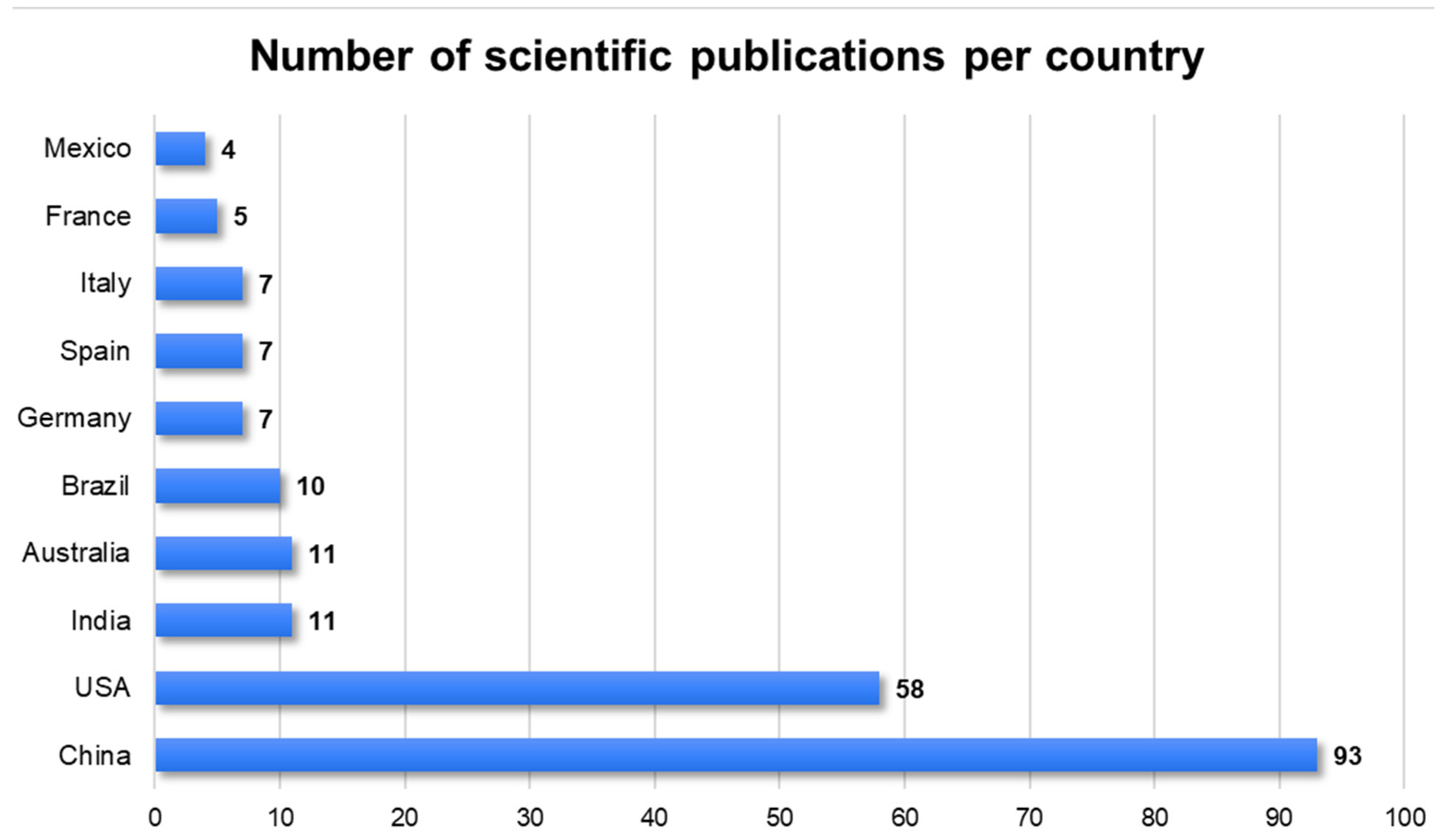
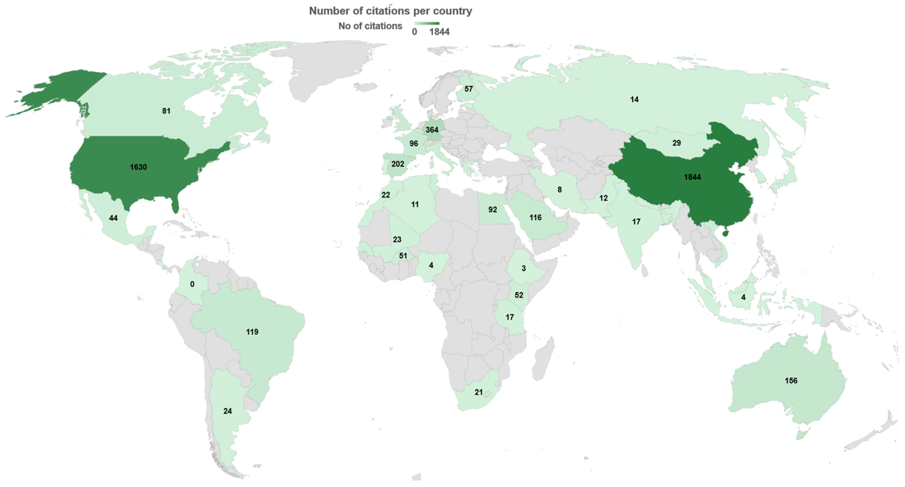
3.1. Key Contributor Countries
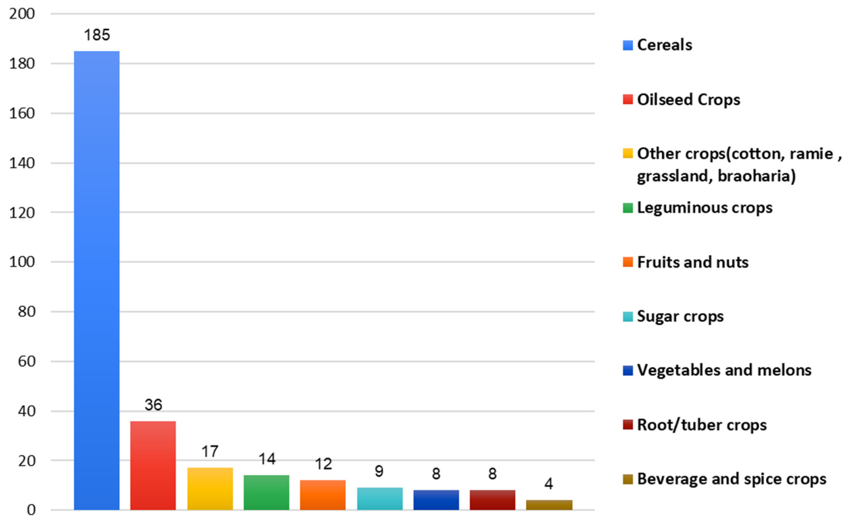
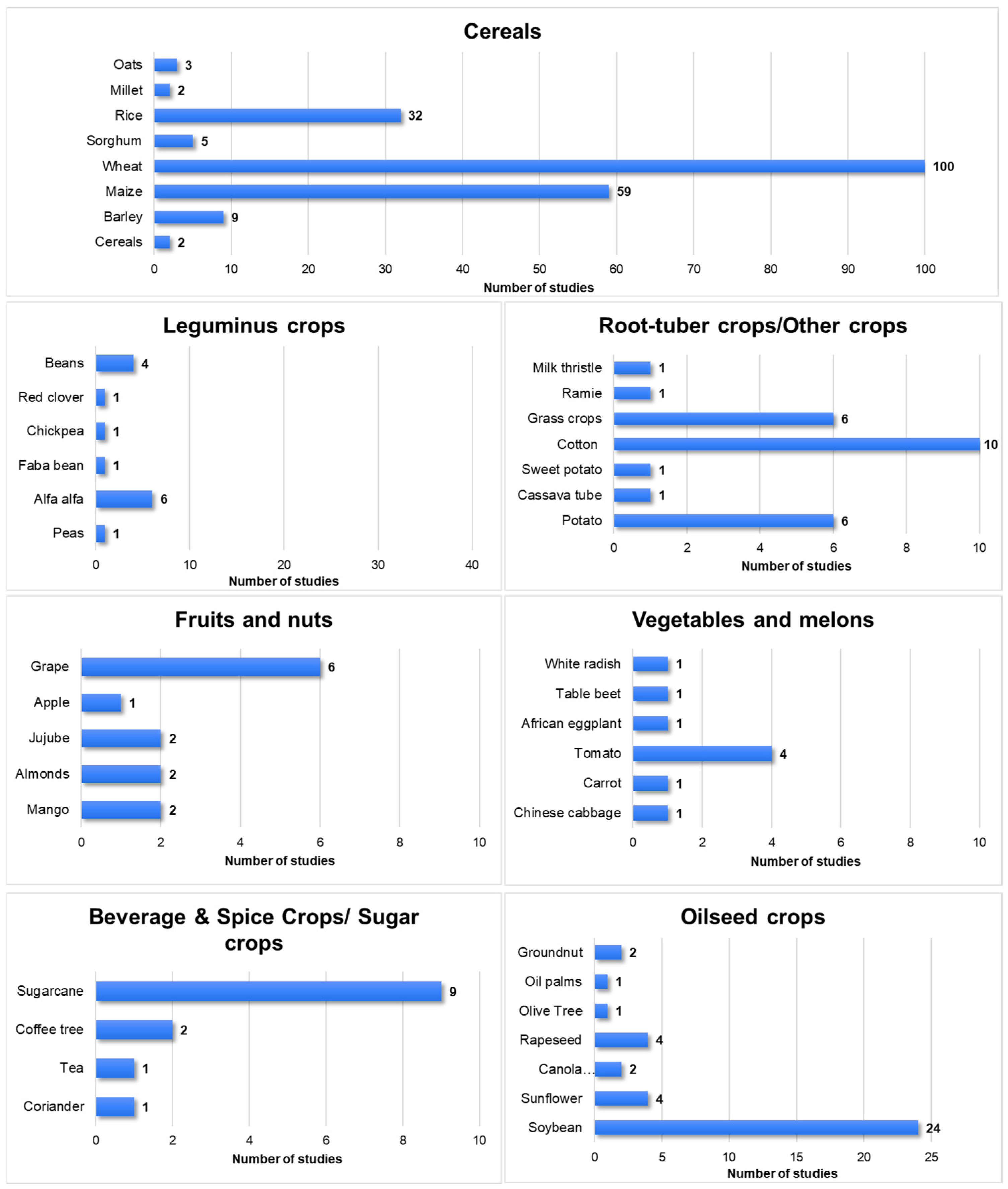
3.2. Crops Used for Yield Estimation
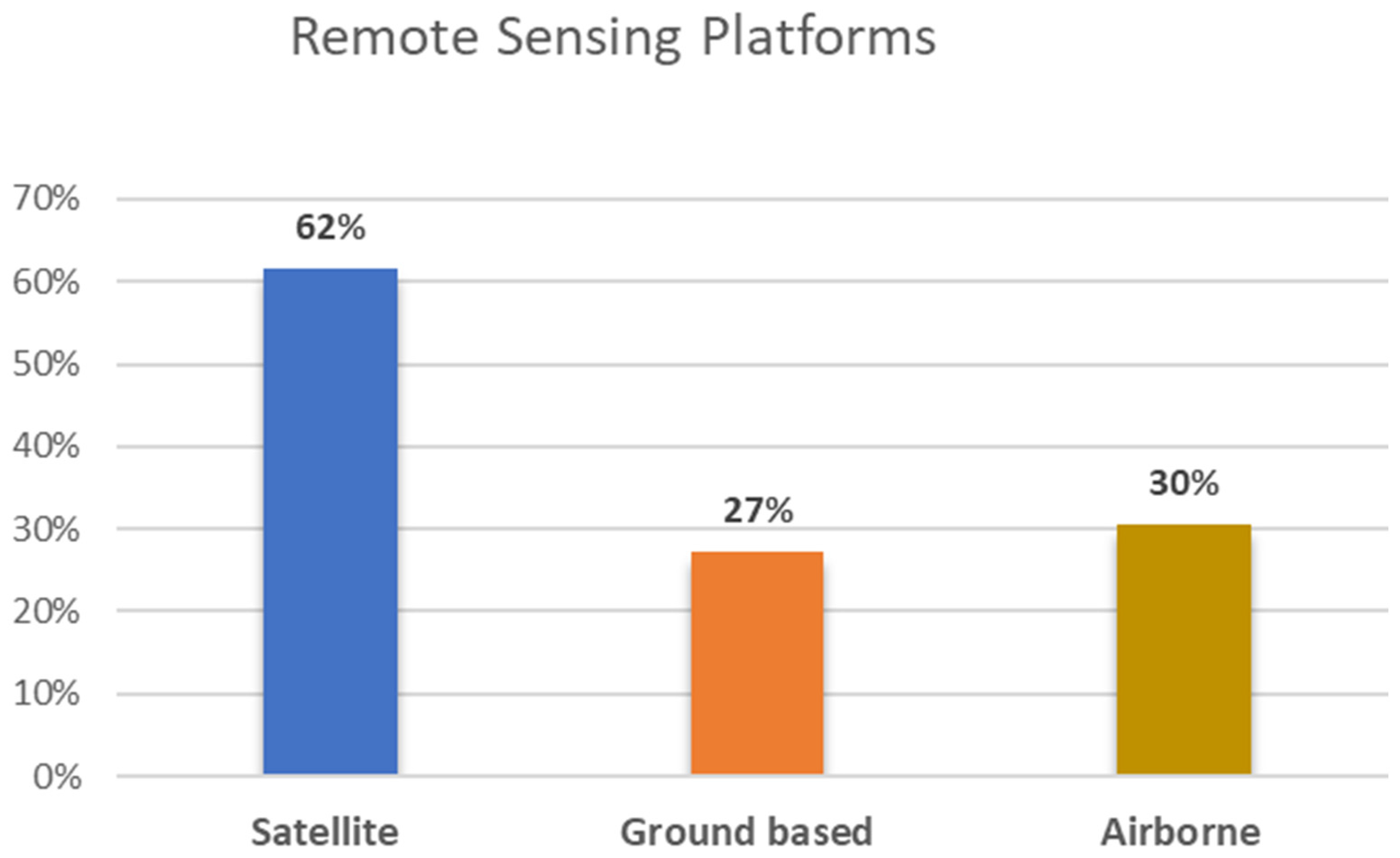
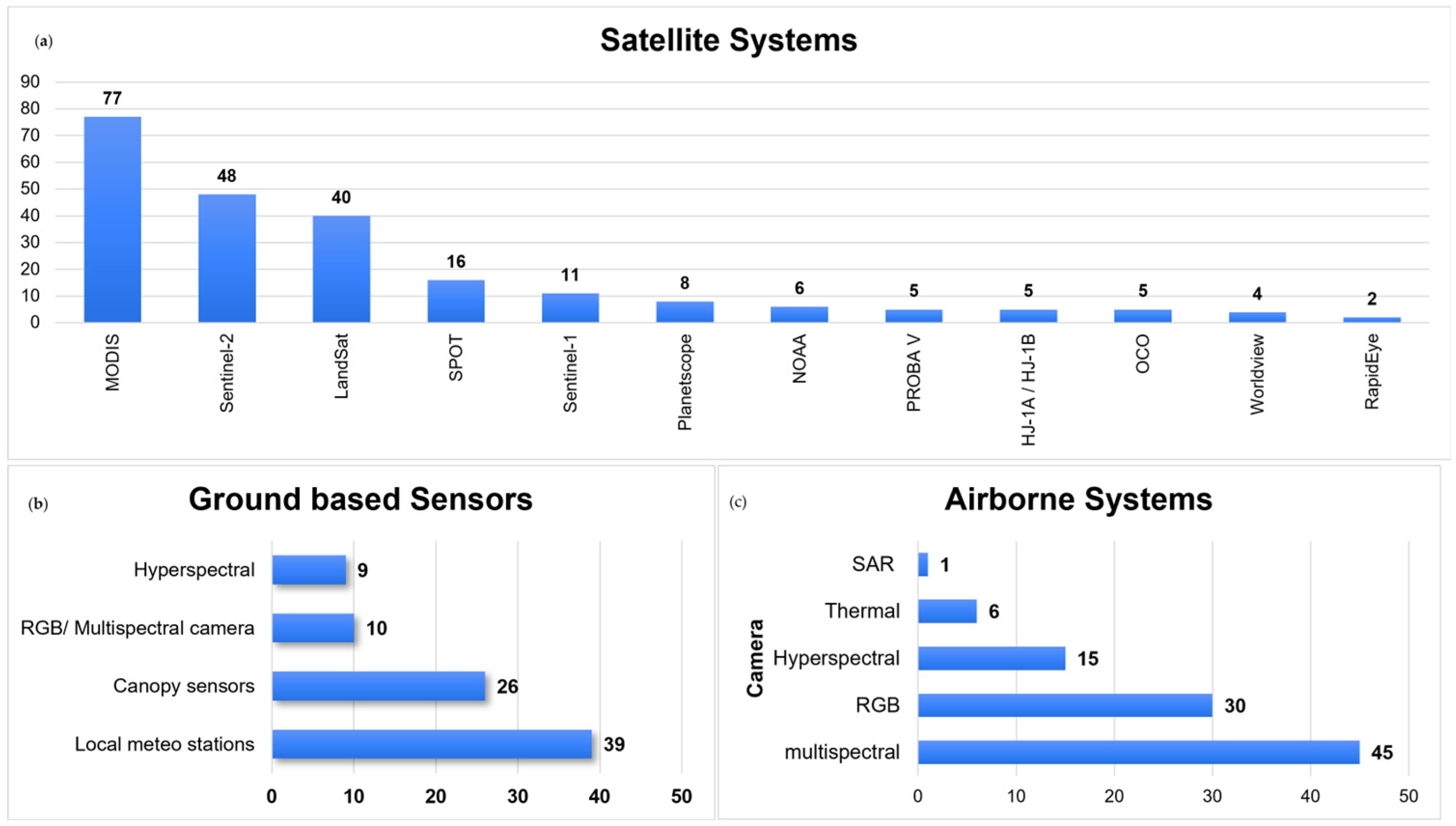
3.3. Remote Sensing Platforms for Yield Forecasting Used in the Literature
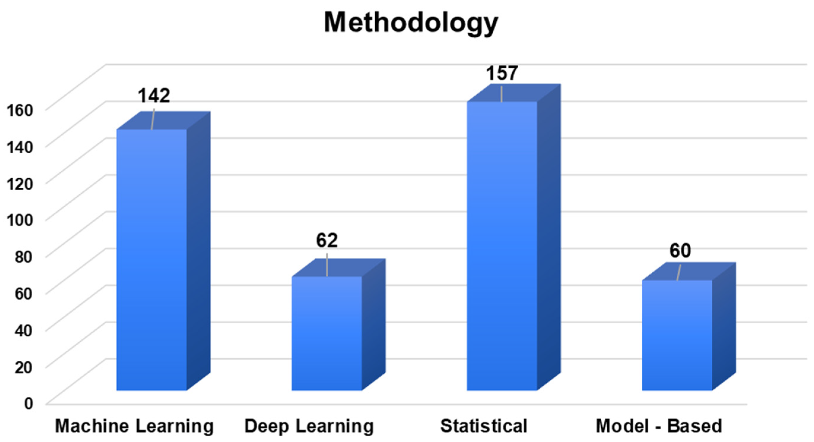
3.4. Data Analysis Techniques for Yield Forecasting Used in the Literature
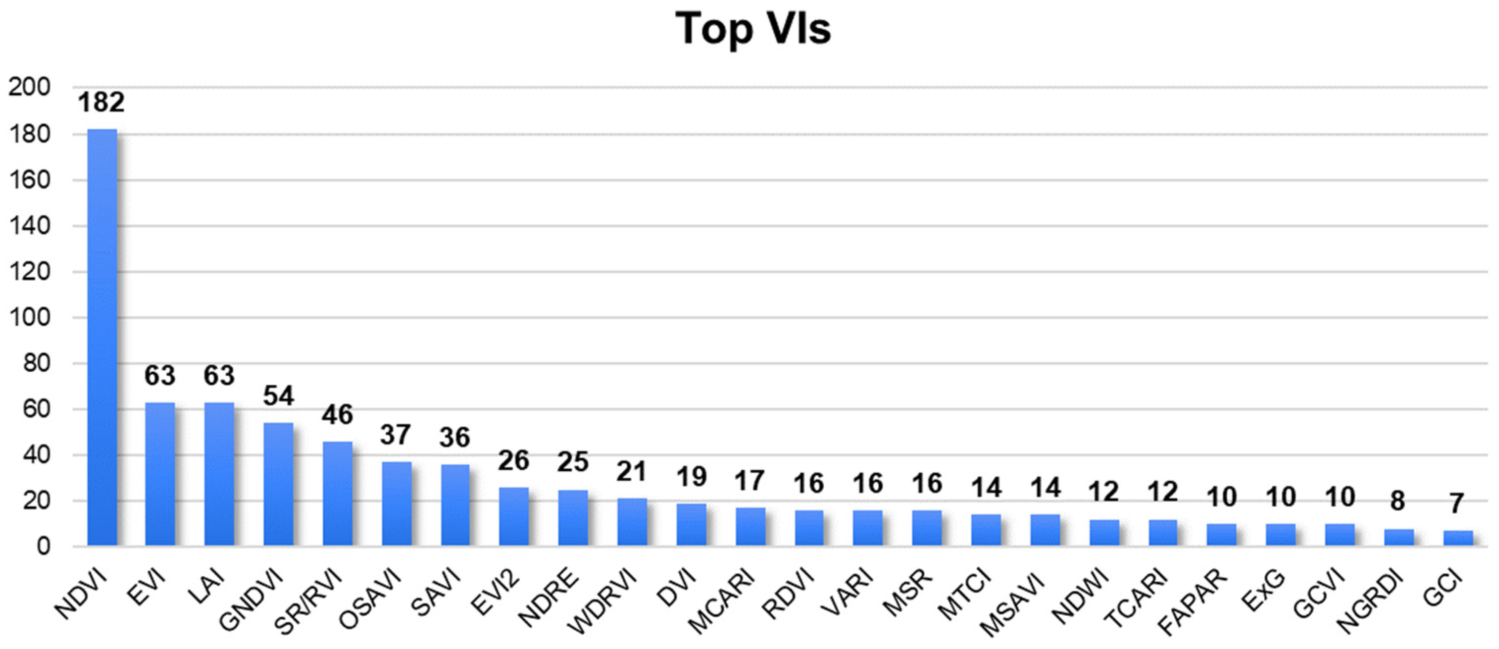
3.5. Spectral Vegetation Indices
3.6. Accuracy Performance per Crop Category
4. Conclusions
Author Contributions
Funding
Data Availability Statement
Conflicts of Interest
Appendix A

| Article | References | Crop | Method | Platform | Year | |
|---|---|---|---|---|---|---|
| 1 | Comparison of earth observing-1 ALI and Landsat ETM+ for crop identification and yield prediction in Mexico | [219] | Maize, Wheat | Statistical | Satellite | 2003 |
| 2 | Early prediction of crop production using drought indices at different timescales and remote sensing data: application in the Ebro Valley (north-east Spain) | [174] | Wheat, Barley | Statistical | Satellite | 2006 |
| 3 | Estimating crop yield from multi-temporal satellite data using multivariate regression and neural network techniques | [102] | Maize, Soybean | ML/DL Statistical | Satellite | 2007 |
| 4 | Mapping sunflower yield as affected by Ridolfia segetum patches and elevation by applying evolutionary product unit neural networks to remote sensed data | [92] | Sunflower | ML/DL Statistical | Airborne | 2008 |
| 5 | Use of Vegetation Health Data for Estimation of Aus Rice Yield in Bangladesh | [184] | Rice | Statistical | Satellite | 2009 |
| 6 | Integrating Vegetation Indices Models and Phenological Classification with Composite SAR and Optical Data for Cereal Yield Estimation in Finland (Part I) | [175] | Summer Wheat, Barley, and Oats | Statistical | Satellite × Airborne × Proximal | 2010 |
| 7 | Cereal Yield Modeling in Finland Using Optical and Radar Remote Sensing | [172] | Cereal | Statistical | Satellite | 2010 |
| 8 | Application of vegetation indices for agricultural crop yield prediction using neural network techniques | [245] | Maize | ML/DL | Airborne | 2010 |
| 9 | Using SPOT data and leaf area index for rice yield estimation in Egyptian Nile delta | [185] | Rice | Statistical | Satellite | 2011 |
| 10 | Estimating regional wheat yield from the shape of decreasing curves of green area index temporal profiles retrieved from MODIS data | [255] | Wheat | Statistical | Satellite | 2012 |
| 11 | Forecasting regional sugarcane yield based on time integral and spatial aggregation of MODIS NDVI | [73] | Sugarcane | Statistical | Satellite × Proximal | 2013 |
| 12 | Estimating regional winter wheat yield by assimilation of time series of HJ-1 CCD NDVI into WOFOST-ACRM model with Ensemble Kalman Filter | [284] | Wheat | Model based | Satellite | 2013 |
| 13 | Enhanced processing of 1-km spatial resolution fAPAR time series for sugarcane yield forecasting and monitoring | [77] | Sugarcane | Statistical | Satellite | 2013 |
| 14 | Remote sensing based yield estimation in a stochastic framework—Case study of durum wheat in Tunisia | [256] | Wheat | Statistical | Satellite | 2013 |
| 15 | Rice yield forecasting models using satellite imagery in Egypt | [186] | Rice | Statistical | Satellite | 2013 |
| 16 | Remotely Sensed Rice Yield Prediction Using Multi-Temporal NDVI Data Derived from NOAA’s-AVHRR | [187] | Rice | Statistical | Satellite | 2013 |
| 17 | Corn yield forecasting in northeast China using remotely sensed spectral indices and crop phenology metrics | [218] | Maize | Statistical | Satellite | 2014 |
| 18 | Estimation of the dynamics and yields of cereals in a semi-arid area using remote sensing and the SAFY growth model | [176] | Wheat and Barley | Model based Statistical | Satellite | 2014 |
| 19 | The use of ALOS/PALSAR data for estimating sugarcane productivity | [75] | Sugarcane | Statistical | Satellite | 2014 |
| 20 | Toward a satellite-based system of sugarcane yield estimation and forecasting in smallholder farming conditions: A case study on reunion island | [76] | Sugarcane | Statistical | Satellite | 2014 |
| 21 | Combined spectral and spatial modeling of corn yield based on aerial images and crop surface models acquired with an unmanned aircraft system | [215] | Maize | Statistical | Airborne | 2014 |
| 22 | Using a remote sensing-supported hydro-agroecological model for field-scale simulation of heterogeneous crop growth and yield: Application for wheat in central Europe | [326] | Wheat | Model based Statistical | Satellite × Proximal | 2015 |
| 23 | Improving winter wheat yield estimation by assimilation of the leaf area index from Landsat TM and MODIS data into the WOFOST model | [267] | Wheat | Model based Statistical | Satellite | 2015 |
| 24 | Assimilation of two variables derived from hyperspectral data into the DSSAT-CERES model for grain yield and quality estimation | [294] | Wheat | Model based Statistical | Proximal | 2015 |
| 25 | Assessment of multimodel ensemble seasonal hindcasts for satellite-based rice yield prediction | [208] | Rice | Statistical | Satellite × Proximal | 2016 |
| 26 | Early Maize Yield Forecasting from Remotely Sensed Temperature/Vegetation Index Measurements | [217] | Maize | Statistical | Satellite | 2016 |
| 27 | Correlation maps to assess soybean yield from EVI data in Paraná State, Brazil | [106] | Soybean | Statistical | Satellite | 2016 |
| 28 | Estimation of winter wheat biomass and yield by combining the aquacrop model and field hyperspectral data | [295] | Wheat | Model based Statistical | Proximal | 2016 |
| 29 | Improving spring maize yield estimation at field scale by assimilating time-series HJ-1 CCD data into the WOFOST model using a new method with fast algorithms | [229] | Maize | Model based | Satellite | 2016 |
| 30 | Prediction of potato crop yield using precision agriculture techniques | [139] | Potato | Statistical | Satellite | 2016 |
| 31 | Rice yield estimation using below cloud remote sensing images acquired by unmanned airborne vehicle system | [210] | Rice | Statistical | Airborne | 2016 |
| 32 | Cotton growth modeling and assessment using unmanned aircraft system visual-band imagery | [143] | Cotton | Statistical | Airborne | 2016 |
| 33 | Daily mapping of 30 m LAI and NDVI for grape yield prediction in California vineyards | [128] | Vineyards | Statistical | Satellite × Proximal | 2017 |
| 34 | Analysis of meteorological variations on wheat yield and its estimation using remotely sensed data. A case study of selected districts of Punjab Province, Pakistan (2001–14) | [257] | Wheat | Statistical | Satellite | 2017 |
| 35 | Forecasting winter wheat yields using MODIS NDVI data for the Central Free State region | [258] | Wheat | Statistical | Satellite | 2017 |
| 36 | Using MODIS Data to Predict Regional Corn Yields | [216] | Maize | Statistical | Satellite | 2017 |
| 37 | Improving Winter Wheat Yield Estimation from the CERES-Wheat Model to Assimilate Leaf Area Index with Different Assimilation Methods and Spatio-Temporal Scales | [327] | Wheat | Model based | Satellite × Proximal | 2017 |
| 38 | Estimation of winter wheat above-ground biomass using unmanned aerial vehicle-based snapshot hyperspectral sensor and crop height improved models | [319] | Wheat | ML Statistical | Airborne × Proximal | 2017 |
| 39 | Assimilation of temporal-spatial leaf area index into the CERES-Wheat model with ensemble Kalman filter and uncertainty assessment for improving winter wheat yield estimation | [300] | Wheat | Model based | Proximal | 2017 |
| 40 | Winter Wheat Production Estimation Based on Environmental Stress Factors from Satellite Observations | [268] | Wheat | Model based Statistical | Satellite | 2018 |
| 41 | Exploring the potential of high-resolution worldview-3 Imagery for estimating yield of mango | [126] | Mango | ML/DL Statistical | Satellite | 2018 |
| 42 | Utilizing Collocated Crop Growth Model Simulations to Train Agronomic Satellite Retrieval Algorithms | [224] | Maize | Model based ML/DL | Satellite | 2018 |
| 43 | Regional crop gross primary productivity and yield estimation using fused Landsat-MODIS data | [160] | Alfalfa, Barley, Maize, Wheat, Peas | Statistical | Satellite | 2018 |
| 44 | Assessing the variability of corn and soybean yields in central Iowa using high spatiotemporal resolution multi-satellite imagery | [108] | Maize and Soybean | Statistical | Satellite | 2018 |
| 45 | Remote estimation of rapeseed yield with unmanned aerial vehicle (UAV) imaging and spectral mixture analysis | [93] | Rapeseed | Statistical | Airborne × Proximal | 2018 |
| 46 | Spatiotemporal analysis of LANDSAT Data for crop yield prediction | [74] | Sugarcane | Statistical | Satellite | 2018 |
| 47 | Multi-year mapping of major crop yields in an irrigation district from high spatial and temporal resolution vegetation index | [91] | Maize, Sunflower | ML | Satellite | 2018 |
| 48 | Forecasting of cereal yields in a semi-arid area using the simple algorithm for yield estimation (Safy) agro-meteorological model combined with optical spot/hrv images | [177] | Wheat, Barley | Model based | Satellite | 2018 |
| 49 | Crop yield estimation using satellite images: Comparison of linear and non-linear model | [103] | Soybean, Maize | ML/DL Statistical | Satellite | 2018 |
| 50 | Estimation of Maize grain yield using multispectral satellite data sets (SPOT 5) and the random forest algorithm | [236] | Maize | ML | Satellite | 2018 |
| 51 | Estimating rice production in the Mekong Delta, Vietnam, utilizing time series of Sentinel-1 SAR data | [189] | Rice | ML | Satellite | 2018 |
| 52 | Modeling and Testing of Growth Status for Chinese Cabbage and White Radish with UAV-Based RGB Imagery | [85] | Chinese Cabbage, and White Radish | Statistical | Airborne | 2018 |
| 53 | Mango yield mapping at the orchard scale based on tree structure and land cover assessed by UAV | [127] | Mango | Statistical | Airborne | 2018 |
| 54 | Forecasting maize yield at field scale based on high-resolution satellite imagery | [220] | Maize | Statistical | Satellite | 2018 |
| 55 | Improving Site-Specific Maize Yield Estimation by Integrating Satellite Multispectral Data into a Crop Model | [226] | Maize | Model based | Satellite | 2019 |
| 56 | Determination of Appropriate Remote Sensing Indices for Spring Wheat Yield Estimation in Mongolia | [334] | Wheat | Statistical | Satellite × Proximal | 2019 |
| 57 | Maize yield estimation in West Africa from crop process-induced combinations of multi-domain remote sensing indices | [237] | Maize | ML Statistical Model based | Satellite | 2019 |
| 58 | A high-resolution, integrated system for rice yield forecasting at district level | [192] | Rice | Model based | Satellite | 2019 |
| 59 | Assimilating MODIS data-derived minimum input data set and water stress factors into CERES-Maize model improves regional corn yield predictions | [227] | Maize | Model based | Satellite | 2019 |
| 60 | County-level soybean yield prediction using deep CNN-LSTM model | [112] | Soybean | ML/DL | Satellite | 2019 |
| 61 | Synergistic integration of optical and microwave satellite data for crop yield estimation | [115] | Maize, Wheat, Soybean | ML Statistical | Satellite | 2019 |
| 62 | Using Solar-Induced Chlorophyll Fluorescence Observed by OCO-2 to Predict Autumn Crop Production in China | [105] | Rice, Maize, Sorghum, Millet, Sweet Potato, and Soybeans | Statistical | Satellite | 2019 |
| 63 | Crop yield estimation using time-series MODIS data and the effects of cropland masks in Ontario, Canada | [107] | Maize and Soybean | Statistical | Satellite | 2019 |
| 64 | California Almond Yield Prediction at the Orchard Level with a Machine Learning Approach | [133] | Almonds | ML/DL Statistical | Satellite × Airborne | 2019 |
| 65 | Joint assimilation of leaf area index and soil moisture from sentinel-1 and sentinel-2 data into the WOFOST model for winter wheat yield estimation | [285] | Wheat | Model based | Satellite | 2019 |
| 66 | High resolution wheat yield mapping using Sentinel-2 | [274] | Wheat | ML Statistical | Satellite | 2019 |
| 67 | Evaluation of regional estimates of winter wheat yield by assimilating three remotely sensed reflectance datasets into the coupled WOFOST–PROSAIL model | [278] | Wheat | Model based | Satellite | 2019 |
| 68 | Assimilating Soil Moisture Retrieved from Sentinel-1 and Sentinel-2 Data into WOFOST Model to Improve Winter Wheat Yield Estimation | [286] | Wheat | Model based | Satellite | 2019 |
| 69 | Improving jujube fruit tree yield estimation at the field scale by assimilating a single Landsat remotely-sensed LAI into the WOFOST model | [135] | Jujube | Model based | Satellite | 2019 |
| 70 | Assimilation of remotely-sensed LAI into WOFOST model with the SUBPLEX algorithm for improving the field-scale jujube yield forecasts | [136] | Jujube | Model based | Satellite | 2019 |
| 71 | Potato yield prediction using machine learning techniques and Sentinel 2 data | [140] | Potato | ML Statistical | Satellite | 2019 |
| 72 | Assessing Multiple Years’ Spatial Variability of Crop Yields Using Satellite Vegetation Indices | [80] | Wheat, Sunflower, and Coriander | Statistical | Satellite | 2019 |
| 73 | Field-scale rice yield estimation using sentinel-1A synthetic aperture radar (SAR) data in coastal saline region of Jiangsu Province, China | [188] | Rice | Statistical | Satellite | 2019 |
| 74 | Rice Yield Estimation Using Parcel-Level Relative Spectral Variables From UAV-Based Hyperspectral Imagery | [211] | Rice | Statistical | Airborne | 2019 |
| 75 | Establishment of Plot-Yield Prediction Models in Soybean Breeding Programs Using UAV-Based Hyperspectral Remote Sensing | [120] | Soybean | Statistical | Airborne | 2019 |
| 76 | Principal variable selection to explain grain yield variation in winter wheat from features extracted from UAV imagery | [301] | Wheat | ML Statistical | Airborne | 2019 |
| 77 | Biomass prediction of heterogeneous temperate grasslands using an SFM approach based on UAV imaging. | [154] | Grassland | Statistical | Airborne | 2019 |
| 78 | Accuracy of carrot yield forecasting using proximal hyperspectral and satellite multispectral data | [83] | Carrot | Statistical | Satellite | 2020 |
| 79 | Sight for Sorghums: Comparisons of Satellite- and Ground-Based Sorghum Yield Estimates in Mali | [182] | Sorghum | Statistical | Satellite | 2020 |
| 80 | Combining multi-source data and machine learning approaches to predict winter wheat yield in the conterminous United States | [329] | Wheat | ML/DL | Satellite × Proximal | 2020 |
| 81 | Multilevel Deep Learning Network for County-Level Corn Yield Estimation in the U.S. Corn Belt | [240] | Maize | ML/DL | Satellite × Proximal | 2020 |
| 82 | Assessing the benefit of satellite-based Solar-Induced Chlorophyll Fluorescence in crop yield prediction | [121] | Maize and Soybean | ML/DL | Satellite × Proximal | 2020 |
| 83 | Estimation of potato yield using satellite data at a municipal level: A machine learning approach | [141] | Potato | ML | Satellite × Proximal | 2020 |
| 84 | Rice Yield Estimation Based on an NPP Model With a Changing Harvest Index | [193] | Rice | Model based | Satellite | 2020 |
| 85 | To blend or not to blend? A framework for nationwide landsat-MODIS data selection for crop yield prediction | [95] | Canola, Wheat, and Barley | Statistical | Satellite | 2020 |
| 86 | Combining Optical, Fluorescence, Thermal Satellite, and Environmental Data to Predict County-Level Maize Yield in China Using Machine Learning Approaches | [241] | Maize | ML/DL | Satellite | 2020 |
| 87 | Prediction of winter wheat yield based on multi-source data and machine learning in China | [265] | Wheat | ML/DL | Satellite | 2020 |
| 88 | The ability of sun-induced chlorophyll fluorescence from OCO-2 and MODIS-EVI to monitor spatial variations of soybean and maize yields in the midwestern USA | [104] | Maize and Soybean | ML/DL Statistical | Satellite | 2020 |
| 89 | Reconstruction of time series leaf area index for improving wheat yield estimates at field scales by fusion of Sentinel-2, -3 and MODIS imagery | [263] | Wheat | Statistical | Satellite | 2020 |
| 90 | Using HJ-CCD image and PLS algorithm to estimate the yield of field-grown winter wheat | [259] | Wheat | Statistical | Satellite | 2020 |
| 91 | Predicting soybean yield at the regional scale using remote sensing and climatic data | [109] | Soybean | Statistical | Satellite | 2020 |
| 92 | High-Resolution Soybean Yield Mapping Across the US Midwest Using Subfield Harvester Data | [122] | Soybean | ML Statistical | Satellite × Proximal | 2020 |
| 93 | Estimating Wheat Grain Yield Using Sentinel-2 Imagery and Exploring Topographic Features and Rainfall Effects on Wheat Performance in Navarre, Spain | [320] | Wheat | ML Statistical | Satellite × Proximal | 2020 |
| 94 | Predicting wheat yield at the field scale by combining high-resolution Sentinel-2 satellite imagery and crop modelling | [333] | Wheat | Statistical | Satellite × Proximal | 2020 |
| 95 | Vineyard yield estimation using 2-D proximal sensing: A multitemporal approach | [129] | Vineyards | ML | Satellite × Proximal | 2020 |
| 96 | Yield prediction by machine learning from UAS-based multi-sensor data fusion in soybean | [123] | Soybean | ML | Airborne × Proximal | 2020 |
| 97 | Remote sensing techniques and stable isotopes as phenotyping tools to assess wheat yield performance: Effects of growing temperature and vernalization | [317] | Wheat | Statistical | Airborne × Proximal | 2020 |
| 98 | Crop yield prediction using multitemporal UAV data and spatio-temporal deep learning models | [178] | Wheat, Barley, and Oats | ML/DL | Airborne × Proximal | 2020 |
| 99 | Validation of white oat yield estimation models using vegetation indices | [181] | White Oat | Statistical | Proximal | 2020 |
| 100 | The role of topography, soil, and remotely sensed vegetation condition towards predicting crop yield | [124] | Maize and Soybean | ML/DL Statistical | Satellite × Proximal | 2020 |
| 101 | Deep phenotyping of yield-related traits in wheat | [296] | Wheat | Statistical | Proximal | 2020 |
| 102 | High-Throughput Field Phenotyping Traits of Grain Yield Formation and Nitrogen Use Efficiency: Optimizing the Selection of Vegetation Indices and Growth Stages | [297] | Wheat | Statistical | Proximal | 2020 |
| 103 | A study on trade-offs between spatial resolution and temporal sampling density for wheat yield estimation using both thermal and calendar time | [260] | Wheat | Statistical | Satellite | 2020 |
| 104 | Estimating yields of household fields in rural subsistence farming systems to study food security in Burkina Faso | [169] | Beans, Maize, Sorghum, and Millet | ML | Satellite | 2020 |
| 105 | Ensemble Machine Learning Methods to Estimate the Sugarcane Yield Based on Remote Sensing Information | [70] | Sugarcane | ML Statistical | Satellite | 2020 |
| 106 | Integrating Landsat-8 and Sentinel-2 Time Series Data for Yield Prediction of Sugarcane Crops at the Block Level | [78] | Sugarcane | ML Statistical | Satellite | 2020 |
| 107 | Alfalfa yield prediction using UAV-based hyperspectral imagery and ensemble learning | [162] | Alfa Alfa | ML/DL | Airborne | 2020 |
| 108 | Estimation of the yield and plant height of winter wheat using UAV-based hyperspectral images | [312] | Wheat | ML/DL | Airborne | 2020 |
| 109 | Aerial hyperspectral imagery and deep neural networks for high-throughput yield phenotyping in wheat | [313] | Wheat | ML/DL | Airborne | 2020 |
| 110 | Modified Red Blue Vegetation Index for Chlorophyll Estimation and Yield Prediction of Maize from Visible Images Captured by UAV | [243] | Maize | ML/DL | Airborne | 2020 |
| 111 | A Canopy Information Measurement Method for Modern Standardized Apple Orchards Based on UAV Multimodal Information | [134] | Apple | ML/DL | Airborne | 2020 |
| 112 | Soybean yield prediction from UAV using multimodal data fusion and deep learning | [117] | Soybean | ML/DL | Airborne | 2020 |
| 113 | Nondestructive estimation of potato yield using relative variables derived from multi-period LAI and hyperspectral data based on weighted growth stage | [67] | Potato | ML | Airborne | 2020 |
| 114 | Use of UAS Multispectral Imagery at Different Physiological Stages for Yield Prediction and Input Resource Optimization in Corn | [246] | Maize | ML/DL Statistical | Airborne | 2020 |
| 115 | Predicting Biomass and Yield in a Tomato Phenotyping Experiment Using UAV Imagery and Random Forest | [89] | Tomato | ML | Airborne | 2020 |
| 116 | Correlating the Plant Height of Wheat with Above-Ground Biomass and Crop Yield Using Drone Imagery and Crop Surface Model, A Case Study from Nepal | [305] | Wheat | Statistical | Airborne | 2020 |
| 117 | Yield estimation in cotton using UAV-based multi-sensor imagery | [144] | Cotton | Statistical | Airborne | 2020 |
| 118 | Bayesian Calibration of the Aquacrop-OS Model for Durum Wheat by Assimilation of Canopy Cover Retrieved from VENµS Satellite Data | [280] | Wheat | Model based | 2020 | |
| 119 | Crop yield prediction through proximal sensing and machine learning algorithms | [142] | Potato | ML Statistical | 2020 | |
| 120 | Seasonal bean yield forecast for non-irrigated croplands through climate and vegetation index data: Geospatial effects | [170] | Beans | Statistical | Satellite × Proximal | 2021 |
| 121 | A deep learning framework under attention mechanism for wheat yield estimation using remotely sensed indices in the Guanzhong Plain, PR China | [330] | Wheat | ML/DL | Satellite × Proximal | 2021 |
| 122 | Geographically and temporally weighted neural network for winter wheat yield prediction | [331] | Wheat | ML/DL Model based Statistical | Satellite × Proximal | 2021 |
| 123 | Improving Wheat Yield Estimates by Integrating a Remotely Sensed Drought Monitoring Index Into the Simple Algorithm for Yield Estimate Model | [332] | Wheat | Model based | Satellite × Proximal | 2021 |
| 124 | Integration of a crop growth model and deep learning methods to improve satellite-based yield estimation of winter wheat in henan province, china | [322] | Wheat | ML/DL Model based | Satellite × Proximal | 2021 |
| 125 | Cereal yield forecasting with satellite drought-based indices, weather data and regional climate indices using machine learning in morocco | [179] | Wheat, Barley | ML Statistical | Satellite × Proximal | 0.88 |
| 126 | A million kernels of truth: Insights into scalable satellite maize yield mapping and yield gap analysis from an extensive ground dataset in the US Corn Belt | [228] | Maize | Model based | Satellite | 2021 |
| 127 | Yield forecasting with machine learning and small data: What gains for grains? | [180] | Wheat, Barley | ML Statistical Model based | Satellite | 2021 |
| 128 | The ARYA crop yield forecasting algorithm: Application to the main wheat exporting countries | [287] | Wheat | Model based | Satellite | 2021 |
| 129 | Corn Biomass Estimation by Integrating Remote Sensing and Long-Term Observation Data Based on Machine Learning Techniques | [242] | Maize | ML/DL | Satellite | 2021 |
| 130 | Exploiting Hierarchical Features for Crop Yield Prediction Based on 3-D Convolutional Neural Networks and Multikernel Gaussian Process | [293] | Wheat | ML/DL | Satellite | 2021 |
| 131 | Crop yield prediction from multi-spectral, multi-temporal remotely sensed imagery using recurrent 3D convolutional neural networks | [1] | Wheat, Maize | ML/DL Statistical | Satellite | 2021 |
| 132 | Prediction of Crop Yield Using Phenological Information Extracted from Remote Sensing Vegetation Index | [232] | Maize | ML | Satellite | 2021 |
| 133 | NDVI Variation and Yield Prediction in Growing Season: A Case Study with Tea in Tanuyen Vietnam | [81] | Tea | ML | Satellite | 2021 |
| 134 | Forecasting Oil Crops Yields on the Regional Scale Using Normalized Difference Vegetation Index | [98] | Sunflower, Winter Rape, and Soybean | Statistical | Satellite | 2021 |
| 135 | Relationship between MODIS Derived NDVI and Yield of Cereals for Selected European Countries | [173] | Cereal | Statistical | Satellite | 2021 |
| 136 | Remote and proximal sensing-derived spectral indices and biophysical variables for spatial variation determination in vineyards | [125] | Vineyards | Statistical | Satellite × Proximal | 2021 |
| 137 | Machine learning models based on remote and proximal sensing as potential methods for in-season biomass yields prediction in commercial sorghum fields | [183] | Sorghum | ML/DL | Satellite × Proximal | 2021 |
| 138 | Machine learning models based on remote and proximal sensing as potential methods for in-season biomass yields prediction in commercial sorghum fields | [247] | Maize | ML Statistical | Satellite × Proximal | 2021 |
| 139 | Long-Term Hindcasts of Wheat Yield in Fields Using Remotely Sensed Phenology, Climate Data and Machine Learning | [321] | Wheat | ML/DL Statistical Model based | Satellite × Proximal | 2021 |
| 140 | Predicting Maize Yield at the Plot Scale of Different Fertilizer Systems by Multi-Source Data and Machine Learning Methods | [248] | Maize | ML Statistical | Satellite × Proximal | 2021 |
| 141 | Forecasting Rainfed Agricultural Production in Arid and Semi-Arid Lands Using Learning Machine Methods: A Case Study | [166] | Chickpea | ML | Satellite × Proximal | 2021 |
| 142 | Wheat yield prediction based on unmanned aerial vehicles-collected red–green–blue imagery | [316] | Wheat | ML/DL Statistical | Airborne × Proximal | 2021 |
| 143 | Entropy Weight Ensemble Framework for Yield Prediction of Winter Wheat Under Different Water Stress Treatments Using Unmanned Aerial Vehicle-Based Multispectral and Thermal Data | [318] | Wheat | Statistical | Airborne × Proximal | 2021 |
| 144 | Assimilation of LAI Derived from UAV Multispectral Data into the SAFY Model to Estimate Maize Yield | [230] | Maize | Model based | Airborne × Proximal | 2021 |
| 145 | Grain Yield Estimation in Rice Breeding Using Phenological Data and Vegetation Indices Derived from UAV Images | [194] | Rice | ML Model based | Airborne × Proximal | 2021 |
| 146 | The feasibility of hand-held thermal and UAV-based multispectral imaging for canopy water status assessment and yield prediction of irrigated African eggplant (Solanum aethopicum L.) | [86] | African Eggplant | Statistical | Airborne × Proximal | 2021 |
| 147 | Improving Biomass and Grain Yield Prediction of Wheat Genotypes on Sodic Soil Using Integrated High-Resolution Multispectral, Hyperspectral, 3D Point Cloud, and Machine Learning Techniques | [314] | Wheat | ML/DL Statistical | Airborne × Proximal | 2021 |
| 148 | Assimilation of coupled microwave/thermal infrared soil moisture profiles into a crop model for robust maize yield estimates over Southeast United States | [231] | Maize | Model based | Proximal | 2021 |
| 149 | An LSTM neural network for improving wheat yield estimates by integrating remote sensing data and meteorological data in the Guanzhong Plain, PR China | [298] | Wheat | ML/DL | Proximal | 2021 |
| 150 | Crop yield prediction based on agrometeorological indexes and remote sensing data | [249] | Maize | ML | Proximal | 2021 |
| 151 | A satellite-based method for national winter wheat yield estimating in china | [279] | Wheat | Model based | Satellite | 2021 |
| 152 | Estimation of Winter Wheat Yield in Arid and Semiarid Regions Based on Assimilated Multi-Source Sentinel Data and the CERES-Wheat Model | [281] | Wheat | Model based | Satellite | 2021 |
| 153 | Winter wheat yield estimation based on assimilated Sentinel-2 images with the CERES-Wheat model | [270] | Wheat | Model based Statistical | Satellite | 2021 |
| 154 | Sugarcane Yield Mapping Using High-Resolution Imagery Data and Machine Learning Technique | [71] | Sugarcane | ML | Satellite | 2021 |
| 155 | Estimation of Crop Yield From Combined Optical and SAR Imagery Using Gaussian Kernel Regression | [190] | Rice | ML | Satellite | 2021 |
| 156 | Integrated method for rice cultivation monitoring using Sentinel-2 data and Leaf Area Index | [191] | Rice | ML | Satellite | 2021 |
| 157 | Remote Sensing-Based Estimation of Advanced Perennial Grass Biomass Yields for Bioenergy | [156] | Perennial Bioenergy Grass | Statistical | Satellite | 2021 |
| 158 | Prediction of Crop Yield for New Mexico Based on Climate and Remote Sensing Data for the 1920–2019 Period | [161] | Alfalfa, Wheat, Maize, and Sorghum | Statistical | Satellite | 2021 |
| 159 | Broadacre Crop Yield Estimation Using Imaging Spectroscopy from Unmanned Aerial Systems (UAS): A Field-Based Case Study with Snap Bean | [167] | Snap Bean | ML/DL | Airborne | 2021 |
| 160 | Combining spectral and textural information in UAV hyperspectral images to estimate rice grain yield | [197] | Rice | ML Statistical | Airborne | 2021 |
| 161 | Temporal Vegetation Indices and Plant Height from Remotely Sensed Imagery Can Predict Grain Yield and Flowering Time Breeding Value in Maize via Machine Learning Regression | [254] | Maize | ML Statistical | Airborne | 2021 |
| 162 | Rice Yield Estimation Based on Vegetation Index and Florescence Spectral Information from UAV Hyperspectral Remote Sensing | [212] | Rice | Statistical | Airborne | 2021 |
| 163 | Creating a Field-Wide Forage Canopy Model Using UAVs and Photogrammetry Processing | [159] | Alfa Alfa | ML | Airborne | 2021 |
| 164 | Maize yield prediction at an early developmental stage using multispectral images and genotype data for preliminary hybrid selection | [244] | Maize | ML/DL | Airborne | 2021 |
| 165 | The Application of an Unmanned Aerial System and Machine Learning Techniques for Red Clover-Grass Mixture Yield Estimation under Variety Performance Trials. | [165] | Red Clover | ML/DL | Airborne | 2021 |
| 166 | Predicting within-field variability in grain yield and protein content of winter wheat using UAV-based multispectral imagery and machine learning approaches | [302] | Winter Wheat | ML/DL | Airborne | 2021 |
| 167 | Cotton yield estimation model based on machine learning using time series UAV remote sensing data | [145] | Cotton | ML/DL | Airborne | 2021 |
| 168 | Assessment of Ensemble Learning to Predict Wheat Grain Yield Based on UAV-Multispectral Reflectance | [307] | Wheat | ML | Airborne | 2021 |
| 169 | Prediction of plant-level tomato biomass and yield using machine learning with unmanned aerial vehicle imagery | [84] | Processing Tomato | ML Statistical | Airborne | 2021 |
| 170 | Improving Accuracy of Herbage Yield Predictions in Perennial Ryegrass with UAV-Based Structural and Spectral Data Fusion and Machine Learning | [155] | Perennial Ryegrass | ML | Airborne | 2021 |
| 171 | Unmanned Aircraft System- (UAS-) Based High-Throughput Phenotyping (HTP) for Tomato Yield Estimation | [90] | Tomato | ML | Airborne | 2021 |
| 172 | Estimation of Fractional Photosynthetically Active Radiation From a Canopy 3D Model; Case Study: Almond Yield Prediction | [132] | Almonds | Statistical | Airborne | 2021 |
| 173 | Combining Spectral and Texture Features of UAV Images for the Remote Estimation of Rice LAI throughout the Entire Growing Season | [209] | Rice | Statistical | Airborne | 2021 |
| 174 | Predicting Table Beet Root Yield with Multispectral UAS Imagery | [87] | Table Beet | Statistical | Airborne | 2021 |
| 175 | Alfalfa (Medicago sativa L.) crop vigor and yield characterization using high-resolution aerial multispectral and thermal infrared imaging technique | [163] | Alfa Alfa | Statistical | Airborne | 2021 |
| 176 | Ramie Yield Estimation Based on UAV RGB Images | [152] | Ramie | Statistical | Airborne | 2021 |
| 177 | Early Estimation of Olive Production from Light Drone Orthophoto, through Canopy Radius | [99] | Olive Tree | Statistical | Airborne | 2021 |
| 178 | Predicting rice yield at pixel scale through synthetic use of crop and deep learning models with satellite data in South and North Korea | [199] | Rice | ML/DL Model based | Satellite × Proximal | 2022 |
| 179 | Improving wheat yield estimates using data augmentation models and remotely sensed biophysical indices within deep neural networks in the Guanzhong Plain, PR China | [323] | Wheat | ML/DL Statistical | Satellite × Proximal | 2022 |
| 180 | Coupling remote sensing and crop growth model to estimate national wheat yield in Ethiopia | [324] | Wheat | Statistical Model based | Satellite × Proximal | 2022 |
| 181 | Assessing the impacts of natural disasters on rice production in Jiangxi, China | [207] | Rice | Statistical | Satellite × Proximal | 2022 |
| 182 | Estimating Groundnut Yield in Smallholder Agriculture Systems Using PlanetScope Data | [96] | Groundnut | ML Statistical | Satellite × Proximal | 2022 |
| 183 | A dataset of winter wheat aboveground biomass in China during 2007–2015 based on data assimilation | [282] | Wheat | Model based | Satellite | 2022 |
| 184 | Accurately mapping global wheat production system using deep learning algorithms | [288] | Wheat | ML/DL | Satellite | 2022 |
| 185 | Improving the Forecasting of Winter Wheat Yields in Northern China with Machine Learning–Dynamical Hybrid Subseasonal-to-Seasonal Ensemble Prediction | [275] | Wheat | ML | Satellite | 2022 |
| 186 | Integrating climate and satellite remote sensing data for predicting county-level wheat yield in China using machine learning methods | [25] | Wheat | ML | Satellite | 2022 |
| 187 | A Geographically Weighted Random Forest Approach to Predict Corn Yield in the US Corn Belt | [233] | Maize | ML | Satellite | 2022 |
| 188 | Spatial Rice Yield Estimation Using Multiple Linear Regression Analysis, Semi-Physical Approach and Assimilating SAR Satellite Derived Products with DSSAT Crop Simulation Model | [200] | Rice | Statistical Model based | Satellite | 2022 |
| 189 | Regional Yield Estimation for Sugarcane Using MODIS and Weather Data: A Case Study in Florida and Louisiana, United States of America | [79] | Sugarcane | Model based | Satellite | 2022 |
| 190 | Rice Yield Prediction and Model Interpretation Based on Satellite and Climatic Indicators Using a Transformer Method | [201] | Rice | ML/DL | Satellite | 2022 |
| 191 | Extreme Gradient Boosting for yield estimation compared with Deep Learning approaches | [113] | Soybean | ML/DL | Satellite | 2022 |
| 192 | Developing a Dual-Stream Deep-Learning Neural Network Model for Improving County-Level Winter Wheat Yield Estimates in China | [289] | Wheat | ML/DL | Satellite | 2022 |
| 193 | A New Framework for Winter Wheat Yield Prediction Integrating Deep Learning and Bayesian Optimization | [290] | Wheat | ML/DL | Satellite | 2022 |
| 194 | Improving Winter Wheat Yield Forecasting Based on Multi-Source Data and Machine Learning | [277] | Wheat | ML Statistical | Satellite | 2022 |
| 195 | Remote Sensing—Based Assessment of the Water-Use Efficiency of Maize over a Large, Arid, Regional Irrigation District | [221] | Maize | Statistical | Satellite | 2022 |
| 196 | In-Season Wheat Yield Forecasting at High Resolution Using Regional Climate Model and Crop Model | [283] | Wheat | Model based | Satellite | 2022 |
| 197 | Winter Wheat Yield Prediction Using an LSTM Model from MODIS LAI Products | [291] | Wheat | ML/DL | Satellite | 2022 |
| 198 | Downscaling solar-induced chlorophyll fluorescence for field-scale cotton yield estimation by a two-step convolutional neural network | [146] | Cotton | ML/DL Statistical | Satellite | 2022 |
| 199 | High-resolution crop yield and water productivity dataset generated using random forest and remote sensing | [234] | Maize, Wheat | ML | Satellite | 2022 |
| 200 | Soybean yield prediction using remote sensing in Southwestern Piauí State, Brazil. | [110] | Soybean | Statistical | Satellite | 2022 |
| 201 | A generalized model to predict large-scale crop yields integrating satellite-based vegetation index time series and phenology metrics | [222] | Maize | Statistical | Satellite | 2022 |
| 202 | Improving crop yield estimation by applying higher resolution satellite NDVI imagery and high-resolution cropland masks | [111] | Maize, Soybeans, Spring Wheat, and Winter Wheat | Statistical | Satellite | 2022 |
| 203 | Wheat growth monitoring and yield estimation based on remote sensing data assimilation into the SAFY crop growth model | [325] | Wheat | Statistical Model based | Satellite × Proximal | 2022 |
| 204 | Simulation of Spatiotemporal Variations in Cotton Lint Yield in the Texas High Plains | [147] | Cotton | Model based | Satellite × Proximal | 2022 |
| 205 | Crop Yield Estimation at Field Scales by Assimilating Time Series of Sentinel-2 Data Into a Modified CASA-WOFOST Coupled Model | [63] | Wheat, Rape, Milk Thistle, and Potato | Model based Statistical | Satellite × Proximal | 2022 |
| 206 | Estimating Maize Yield in the Black Soil Region of Northeast China Using Land Surface Data Assimilation: Integrating a Crop Model and Remote Sensing | [250] | Maize | Model based ML | Satellite × Proximal | 2022 |
| 207 | Assimilation of Remote Sensing Data into Crop Growth Model for Yield Estimation: A Case Study from India | [97] | Rice, Groundnut, Maize | ML/DL Model based | Satellite × Proximal | 2022 |
| 208 | Evaluation of Random Forests (RF) for Regional and Local-Scale Wheat Yield Prediction in Southeast Australia | [328] | Wheat | ML | Satellite × Proximal | 2022 |
| 209 | Assimilation of Multisensor Optical and Multiorbital SAR Satellite Data in a Simplified Agrometeorological Model for Rapeseed Crops Monitoring | [94] | Winter Rapeseed | Model based | Satellite × Proximal | 2022 |
| 210 | Maize yield prediction using NDVI derived from Sentinal 2 data in Siddipet district of Telangana state | [213] | Maize | Statistical | Satellite Proximal | 2022 |
| 211 | Maize Yield Estimation in Intercropped Smallholder Fields Using Satellite Data in Southern Malawi | [223] | Maize | Statistical | Satellite × Proximal | 2022 |
| 212 | Multispectral remote sensing for accurate acquisition of rice phenotypes: Impacts of radiometric calibration and unmanned aerial vehicle flying altitudes | [196] | Rice | ML/DL | Airborne × Proximal | 2022 |
| 213 | Predicting In-Season Corn Grain Yield Using Optical Sensors | [214] | Maize | Statistical | Airborne × Proximal | 2022 |
| 214 | Cotton yield prediction using drone derived LAI and chlorophyll content | [137] | Cotton | Statistical | Airborne × Proximal | 2022 |
| 215 | Remotely Sensed Prediction of Rice Yield at Different Growth Durations Using UAV Multispectral Imagery | [203] | Rice | Statistical | Airborne × Proximal | 2022 |
| 216 | Correlation between Ground Measurements and UAV Sensed Vegetation Indices for Yield Prediction of Common Bean Grown under Different Irrigation Treatments and Sowing Periods | [168] | Beans | Statistical | Airborne × Proximal | 2022 |
| 217 | Detecting Intra-Field Variation in Rice Yield With Unmanned Aerial Vehicle Imagery and Deep Learning | [195] | Rice | ML/DL Statistical | Airborne × Proximal | 2022 |
| 218 | Comparison of Winter Wheat Yield Estimation Based on Near-Surface Hyperspectral and UAV Hyperspectral Remote Sensing Data | [315] | Wheat | ML/DL Statistical | Airborne × Proximal | 2022 |
| 219 | Estimating Yield-Related Traits Using UAV-Derived Multispectral Images to Improve Rice Grain Yield Prediction | [204] | Rice | ML Statistical | Airborne × Proximal | 2022 |
| 220 | Cotton Yield Estimation From Aerial Imagery Using Machine Learning Approaches | [148] | Cotton | ML | Airborne × Proximal | 2022 |
| 221 | Rice Yield Estimation Based on Continuous Wavelet Transform With Multiple Growth Period | [205] | Rice | ML Statistical | Proximal | 2022 |
| 222 | Deciphering the contributions of spectral and structural data to wheat yield estimation from proximal sensing | [299] | Wheat | ML/DL | Proximal | 2022 |
| 223 | End-to-end deep learning for directly estimating grape yield from ground-based imagery | [130] | Vineyards | ML/DL | Proximal | 2022 |
| 224 | Comparing a New Non-Invasive Vineyard Yield Estimation Approach Based on Image Analysis with Manual Sample-Based Methods | [131] | Vineyards | ML Statistical | Proximal | 2022 |
| 225 | Predictive Modeling of Above-Ground Biomass in Brachiaria Pastures from Satellite and UAV Imagery Using Machine Learning Approaches | [157] | Brachiaria Pastures | ML | Satellite × Airborne | 2022 |
| 226 | Transfer-Learning-Based Approach for Yield Prediction of Winter Wheat from Planet Data and SAFY Model | [264] | Wheat | ML/DL Model based | Satellite | 2022 |
| 227 | Evaluation of Different Modelling Techniques with Fusion of Satellite, Soil and Agro-Meteorological Data for the Assessment of Durum Wheat Yield under a Large Scale Application | [271] | Wheat | ML Model based | Satellite | 2022 |
| 228 | Kernel Ridge Regression Hybrid Method for Wheat Yield Prediction with Satellite-Derived Predictors | [276] | Wheat | ML Statistical | Satellite | 2022 |
| 229 | Early season prediction of within-field crop yield variability by assimilating CubeSat data into a crop model | [252] | Maize | Statistical Model based | Satellite | 2022 |
| 230 | Assessing the Yield of Wheat Using Satellite Remote Sensing-Based Machine Learning Algorithms and Simulation Modeling | [272] | Wheat | ML Model based | Satellite | 2022 |
| 231 | Linking Remote Sensing with APSIM through Emulation and Bayesian Optimization to Improve Yield Prediction | [225] | Maize | ML/DL Model based | Satellite | 2022 |
| 232 | Subfield maize yield prediction improves when in-season crop water deficit is included in remote sensing imagery-based models | [253] | Maize | ML Model based | Satellite | 2022 |
| 233 | Wheat Crop Yield Estimation using Geomatics Tools in Saharanpur District | [262] | Wheat | Statistical | Satellite | 2022 |
| 234 | Early Prediction of Coffee Yield in the Central Highlands of Vietnam Using a Statistical Approach and Satellite Remote Sensing Vegetation Biophysical Variables | [82] | Coffee Tree | Statistical Model based | Satellite | 2022 |
| 235 | A deep learning multi-layer perceptron and remote sensing approach for soil health based crop yield estimation | [266] | Wheat | ML/DL Statistical | Satellite | 2022 |
| 236 | Field-level crop yield estimation with PRISMA and Sentinel-2 | [114] | Maize, Rice, Soybean, Wheat | ML | Satellite | 2022 |
| 237 | Wheat yield estimation using remote sensing data based on machine learning approaches | [292] | Wheat | ML/DL | Satellite | 2022 |
| 238 | Winter Wheat Yield Estimation Based on Optimal Weighted Vegetation Index and BHT-ARIMA Model | [269] | Wheat | Statistical Model based | Satellite | 2022 |
| 239 | Oil Palm Yield Estimation Based on Vegetation and Humidity Indices Generated from Satellite Images and Machine Learning Techniques | [100] | Palm Oil | ML/DL | Satellite | 2022 |
| 240 | Soya Yield Prediction on a Within-Field Scale Using Machine Learning Models Trained on Sentinel-2 and Soil Data | [116] | Soybean | ML | Satellite | 2022 |
| 241 | Coffee-Yield Estimation Using High-Resolution Time-Series Satellite Images and Machine Learning | [72] | Coffee Tree | ML Statistical | Satellite | 2022 |
| 242 | Alfalfa yield estimation based on time series of Landsat 8 and PROBA-V images: An investigation of machine learning techniques and spectral-temporal features | [164] | Alfa Alfa | ML Statistical | Satellite | 2022 |
| 243 | A Comprehensive Comparison of Machine Learning and Feature Selection Methods for Maize Biomass Estimation Using Sentinel-1 SAR, Sentinel-2 Vegetation Indices, and Biophysical Variables | [235] | Maize | ML | Satellite | 2022 |
| 244 | In-Season Prediction of Corn Grain Yield through PlanetScope and Sentinel-2 Images | [238] | Maize | ML Statistical | Satellite | 2022 |
| 245 | Wheat Yield Estimation Using Remote Sensing Indices Derived from Sentinel-2 Time Series and Google Earth Engine in a Highly Fragmented and Heterogeneous Agricultural Region | [273] | Wheat | ML Statistical | Satellite | 2022 |
| 246 | Field Data Collection Methods Strongly Affect Satellite-Based Crop Yield Estimation | [239] | Maize | ML Statistical | Satellite | 2022 |
| 247 | Development of a Multi-Scale Tomato Yield Prediction Model in Azerbaijan Using Spectral Indices from Sentinel-2 Imagery | [88] | Processing Tomato | Statistical | Satellite | 2022 |
| 248 | The Potential of Using Radarsat-2 Satellite Image for Modeling and Mapping Wheat Yield in a Semiarid Environment | [261] | Wheat | Statistical | Satellite | 2022 |
| 249 | Radiative transfer model inversion using high-resolution hyperspectral airborne imagery—Retrieving maize LAI to access biomass and grain yield | [251] | Maize | Statistical Model based | Airborne | 2022 |
| 250 | UAV-Based Hyperspectral and Ensemble Machine Learning for Predicting Yield in Winter Wheat | [306] | Wheat | ML | Airborne | 2022 |
| 251 | Multisite and Multitemporal Grassland Yield Estimation Using UAV-Borne Hyperspectral Data | [153] | Grassland | ML | Airborne | 2022 |
| 252 | Transferability of Models for Predicting Rice Grain Yield from Unmanned Aerial Vehicle (UAV) Multispectral Imagery across Years, Cultivars and Sensors | [198] | Rice | ML Statistical | Airborne | 2022 |
| 253 | Field-scale rice yield estimation based on UAV-based MiniSAR data with Ku band and modified water-cloud model of panicle layer at panicle stage | [206] | Rice | Statistical Model based | Airborne | 2022 |
| 254 | UAV Remote Sensing for High-Throughput Phenotyping and for Yield Prediction of Miscanthus by Machine Learning Techniques | [158] | Miscanthus | ML Statistical Model based | Airborne | 2022 |
| 255 | UAV Remote Sensing Prediction Method of Winter Wheat Yield Based on the Fused Features of Crop and Soil | [303] | Wheat | ML/DL | Airborne | 2022 |
| 256 | Deep Convolutional Neural Network for Rice Density Prescription Map at Ripening Stage Using Unmanned Aerial Vehicle-Based Remotely Sensed Images | [202] | Rice | ML/DL | Airborne | 2022 |
| 257 | Estimation of soybean yield parameters under lodging conditions using RGB information from unmanned aerial vehicles | [118] | Soybean | ML/DL | Airborne | 2022 |
| 258 | Improving Wheat Yield Prediction Accuracy Using LSTM-RF Framework Based on UAV Thermal Infrared and Multispectral Imagery | [304] | Wheat | ML/DL | Airborne | 2022 |
| 259 | Yield estimation of high-density cotton fields using low-altitude UAV imaging and deep learning | [138] | Cotton | ML/DL Statistical | Airborne | 2022 |
| 260 | Preharvest phenotypic prediction of grain quality and yield of durum wheat using multispectral imaging | [311] | Wheat | ML/DL Statistical | Airborne | 2022 |
| 261 | Estimation of soybean grain yield from multispectral high-resolution UAV data with machine learning models in West Africa | [119] | Soybean | ML | Airborne | 2022 |
| 262 | Cotton Yield Estimation Using the Remotely Sensed Cotton Boll Index from UAV Images | [149] | Cotton | ML Statistical | Airborne | 2022 |
| 263 | UAV-based multi-sensor data fusion and machine learning algorithm for yield prediction in wheat | [308] | Wheat | ML | Airborne | 2022 |
| 264 | Prediction of Field-Scale Wheat Yield Using Machine Learning Method and Multi-Spectral UAV Data | [309] | Wheat | ML. | Airborne | 2022 |
| 265 | Cotton Yield Estimation Based on Vegetation Indices and Texture Features Derived From RGB Image | [150] | Cotton | ML Statistical | Airborne | 2022 |
| 266 | Estimation of plant height and yield based on UAV imagery in faba bean (Vicia faba L.) | [171] | Faba Bean | ML Statistical | Airborne | 2022 |
| 267 | The Optimal Phenological Phase of Maize for Yield Prediction with High-Frequency UAV Remote Sensing | [310] | Maize | ML | Airborne | 2022 |
| 268 | High-Resolution Flowering Index for Canola Yield Modelling | [101] | Canola Seed | Statistical | Airborne | 2022 |
| 269 | UAV-Based Multispectral Imagery for Estimating Cassava Tuber Yields | [151] | Cassava Tuber | Statistical | Airborne | 2022 |
References
- Qiao, M.; He, X.; Cheng, X.; Li, P.; Luo, H.; Zhang, L.; Tian, Z. Crop Yield Prediction from Multi-Spectral, Multi-Temporal Remotely Sensed Imagery Using Recurrent 3D Convolutional Neural Networks. Int. J. Appl. Earth Obs. Geoinf. 2021, 102, 102436. [Google Scholar] [CrossRef]
- WHO. World Hunger Is Still Not Going down after Three Years and Obesity Is Still Growing—UN Report. Available online: https://www.who.int/news/item/15-07-2019-world-hunger-is-still-not-going-down-after-three-years-and-obesity-is-still-growing-un-report (accessed on 17 May 2023).
- The-Sustainable-Development-Goals-Report-2022.Pdf. Available online: https://unstats.un.org/sdgs/report/2022/The-Sustainable-Development-Goals-Report-2022.pdf (accessed on 20 August 2023).
- Mase, A.S.; Prokopy, L.S. Unrealized Potential: A Review of Perceptions and Use of Weather and Climate Information in Agricultural Decision Making. Weather Clim. Soc. 2014, 6, 47–61. [Google Scholar] [CrossRef]
- Xu, X.; Gao, P.; Zhu, X.; Guo, W.; Ding, J.; Li, C.; Zhu, M.; Wu, X. Design of an Integrated Climatic Assessment Indicator (ICAI) for Wheat Production: A Case Study in Jiangsu Province, China. Ecol. Indic. 2019, 101, 943–953. [Google Scholar] [CrossRef]
- Chlingaryan, A.; Sukkarieh, S.; Whelan, B. Machine Learning Approaches for Crop Yield Prediction and Nitrogen Status Estimation in Precision Agriculture: A Review. Comput. Electron. Agric. 2018, 151, 61–69. [Google Scholar] [CrossRef]
- Wu, B.; Zhang, M.; Zeng, H.; Tian, F.; Potgieter, A.B.; Qin, X.; Yan, N.; Chang, S.; Zhao, Y.; Dong, Q.; et al. Challenges and Opportunities in Remote Sensing-Based Crop Monitoring: A Review. Natl. Sci. Rev. 2023, 10, nwac290. [Google Scholar] [CrossRef]
- Ali, A.M.; Abouelghar, M.; Belal, A.A.; Saleh, N.; Yones, M.; Selim, A.I.; Amin, M.E.S.; Elwesemy, A.; Kucher, D.E.; Maginan, S.; et al. Crop Yield Prediction Using Multi Sensors Remote Sensing (Review Article). Egypt. J. Remote Sens. Space Sci. 2022, 25, 711–716. [Google Scholar] [CrossRef]
- Atzberger, C. Advances in Remote Sensing of Agriculture: Context Description, Existing Operational Monitoring Systems and Major Information Needs. Remote Sens. 2013, 5, 949–981. [Google Scholar] [CrossRef]
- Huang, J.; Gómez-Dans, J.L.; Huang, H.; Ma, H.; Wu, Q.; Lewis, P.E.; Liang, S.; Chen, Z.; Xue, J.-H.; Wu, Y.; et al. Assimilation of Remote Sensing into Crop Growth Models: Current Status and Perspectives. Agric. For. Meteorol. 2019, 276, 107609. [Google Scholar] [CrossRef]
- Tandzi, L.N.; Mutengwa, C.S. Estimation of Maize (Zea mays L.) Yield Per Harvest Area: Appropriate Methods. Agronomy 2020, 10, 29. [Google Scholar] [CrossRef]
- Hongo, C.; Niwa, K. Yield prediction of sugar beet using agricultural spatial information. J. Jpn. Soc. Precis. Eng. 2013, 79, 991–994. [Google Scholar] [CrossRef]
- Dela Torre, D.M.G.; Gao, J.; Macinnis-Ng, C. Remote Sensing-Based Estimation of Rice Yields Using Various Models: A Critical Review. Geo-Spat. Inf. Sci. 2021, 24, 580–603. [Google Scholar] [CrossRef]
- Som-Ard, J.; Atzberger, C.; Izquierdo-Verdiguier, E.; Vuolo, F.; Immitzer, M. Remote Sensing Applications in Sugarcane Cultivation: A Review. Remote Sens. 2021, 13, 4040. [Google Scholar] [CrossRef]
- Giovos, R.; Tassopoulos, D.; Kalivas, D.; Lougkos, N.; Priovolou, A. Remote Sensing Vegetation Indices in Viticulture: A Critical Review. Agriculture 2021, 11, 457. [Google Scholar] [CrossRef]
- Pinter, P.J., Jr.; Hatfield, J.L.; Schepers, J.S.; Barnes, E.M.; Moran, M.S.; Daughtry, C.S.T.; Upchurch, D.R. Remote Sensing for Crop Management. Photogramm. Eng. Remote Sens. 2003, 69, 647–664. [Google Scholar] [CrossRef]
- Dobrota, C.T.; Carpa, R.; Butiuc-Keul, A. Analysis of Designs Used in Monitoring Crop Growth Based on Remote Sensing Methods. Turk. J. Agric. For. 2021, 45, 730–742. [Google Scholar] [CrossRef]
- Potgieter, A.B.; Zhao, Y.; Zarco-Tejada, P.J.; Chenu, K.; Zhang, Y.; Porker, K.; Biddulph, B.; Dang, Y.P.; Neale, T.; Roosta, F.; et al. Evolution and Application of Digital Technologies to Predict Crop Type and Crop Phenology in Agriculture. Silico Plants 2021, 3, diab017. [Google Scholar] [CrossRef]
- Inoue, Y. Synergy of Remote Sensing and Modeling for Estimating Ecophysiological Processes in Plant Production. Plant Prod. Sci. 2003, 6, 3–16. [Google Scholar] [CrossRef]
- Muruganantham, P.; Wibowo, S.; Grandhi, S.; Samrat, N.H.; Islam, N. A Systematic Literature Review on Crop Yield Prediction with Deep Learning and Remote Sensing. Remote Sens. 2022, 14, 1990. [Google Scholar] [CrossRef]
- Benos, L.; Tagarakis, A.C.; Dolias, G.; Berruto, R.; Kateris, D.; Bochtis, D. Machine Learning in Agriculture: A Comprehensive Updated Review. Sensors 2021, 21, 3758. [Google Scholar] [CrossRef]
- Schauberger, B.; Jägermeyr, J.; Gornott, C. A Systematic Review of Local to Regional Yield Forecasting Approaches and Frequently Used Data Resources. Eur. J. Agron. 2020, 120, 126153. [Google Scholar] [CrossRef]
- Rashid, M.; Bari, B.S.; Yusup, Y.; Kamaruddin, M.A.; Khan, N. A Comprehensive Review of Crop Yield Prediction Using Machine Learning Approaches with Special Emphasis on Palm Oil Yield Prediction. IEEE Access 2021, 9, 63406–63439. [Google Scholar] [CrossRef]
- Darwin, B.; Dharmaraj, P.; Prince, S.; Popescu, D.E.; Hemanth, D.J. Recognition of Bloom/Yield in Crop Images Using Deep Learning Models for Smart Agriculture: A Review. Agronomy 2021, 11, 646. [Google Scholar] [CrossRef]
- Zhou, W.; Liu, Y.; Ata-Ul-Karim, S.T.; Ge, Q.; Li, X.; Xiao, J. Integrating Climate and Satellite Remote Sensing Data for Predicting County-Level Wheat Yield in China Using Machine Learning Methods. Int. J. Appl. Earth Obs. Geoinf. 2022, 111, 102861. [Google Scholar] [CrossRef]
- Jeong, J.H.; Resop, J.P.; Mueller, N.D.; Fleisher, D.H.; Yun, K.; Butler, E.E.; Timlin, D.J.; Shim, K.-M.; Gerber, J.S.; Reddy, V.R.; et al. Random Forests for Global and Regional Crop Yield Predictions. PLoS ONE 2016, 11, e0156571. [Google Scholar] [CrossRef]
- Basso, B.; Cammarano, D.; Carfagna, E. Review of Crop Yield Forecasting Methods and Early Warning Systems. In Proceedings of the First Meeting of the Scientific Advisory Committee of the Global Strategy to Improve Agricultural and Rural Statistics, Rome, Italy, 18–19 July 2013. [Google Scholar]
- Darra, N.; Espejo-Garcia, B.; Kasimati, A.; Kriezi, O.; Psomiadis, E.; Fountas, S. Can Satellites Predict Yield? Ensemble Machine Learning and Statistical Analysis of Sentinel-2 Imagery for Processing Tomato Yield Prediction. Sensors 2023, 23, 2586. [Google Scholar] [CrossRef]
- Zheng, C.; Abd-elrahman, A.; Whitaker, V. Remote Sensing and Machine Learning in Crop Phenotyping and Management, with an Emphasis on Applications in Strawberry Farming. Remote Sens. 2021, 13, 531. [Google Scholar] [CrossRef]
- Diaz-Gonzalez, F.A.; Vuelvas, J.; Correa, C.A.; Vallejo, V.E.; Patino, D. Machine Learning and Remote Sensing Techniques Applied to Estimate Soil Indicators—Review. Ecol. Indic. 2022, 135, 108517. [Google Scholar] [CrossRef]
- Jhajharia, K.; Mathur, P. A Comprehensive Review on Machine Learning in Agriculture Domain. IAES Int. J. Artif. Intell. 2022, 11, 753–763. [Google Scholar] [CrossRef]
- Van Klompenburg, T.; Kassahun, A.; Catal, C. Crop Yield Prediction Using Machine Learning: A Systematic Literature Review. Comput. Electron. Agric. 2020, 177, 105709. [Google Scholar] [CrossRef]
- Oikonomidis, A.; Catal, C.; Kassahun, A. Deep Learning for Crop Yield Prediction: A Systematic Literature Review. N. Z. J. Crop Hortic. Sci. 2023, 51, 1–26. [Google Scholar] [CrossRef]
- Goodfellow, I.; Bengio, Y.; Courville, A. Deep Learning; MIT Press: Cambridge, MA, USA, 2016; ISBN 978-0-262-33737-3. [Google Scholar]
- Khaki, S.; Pham, H.; Wang, L. Simultaneous Corn and Soybean Yield Prediction from Remote Sensing Data Using Deep Transfer Learning. Sci. Rep. 2021, 11, 11132. [Google Scholar] [CrossRef] [PubMed]
- Leukel, J.; Zimpel, T.; Stumpe, C. Machine Learning Technology for Early Prediction of Grain Yield at the Field Scale: A Systematic Review. Comput. Electron. Agric. 2023, 207, 107721. [Google Scholar] [CrossRef]
- Filippi, P.; Jones, E.J.; Wimalathunge, N.S.; Somarathna, P.D.S.N.; Pozza, L.E.; Ugbaje, S.U.; Jephcott, T.G.; Paterson, S.E.; Whelan, B.M.; Bishop, T.F.A. An Approach to Forecast Grain Crop Yield Using Multi-Layered, Multi-Farm Data Sets and Machine Learning. Precis. Agric. 2019, 20, 1015–1029. [Google Scholar] [CrossRef]
- Moher, D.; Liberati, A.; Tetzlaff, J.; Altman, D.G. Preferred Reporting Items for Systematic Reviews and Meta-Analyses: The PRISMA Statement. Int. J. Surg. 2010, 8, 336–341. [Google Scholar] [CrossRef]
- Barriguinha, A.; de Castro Neto, M.; Gil, A. Vineyard Yield Estimation, Prediction, and Forecasting: A Systematic Literature Review. Agronomy 2021, 11, 1789. [Google Scholar] [CrossRef]
- Dainelli, R.; Saracco, F. Bibliometric and Social Network Analysis on the Use of Satellite Imagery in Agriculture: An Entropy-Based Approach. Agronomy 2023, 13, 576. [Google Scholar] [CrossRef]
- Xie, Y.; Ji, L.; Zhang, B.; Huang, G. Evolution of the Scientific Literature on Input–Output Analysis: A Bibliometric Analysis of 1990–2017. Sustainability 2018, 10, 3135. [Google Scholar] [CrossRef]
- CLASSIFICATION OF CROPS. Available online: https://www.fao.org/fileadmin/templates/ess/documents/world_census_of_agriculture/appendix3_r7.pdf (accessed on 20 August 2023).
- Dutta, A.; Trivedi, A.; Nath, C.P.; Gupta, D.S.; Hazra, K.K. A Comprehensive Review on Grain Legumes as Climate-smart Crops: Challenges and Prospects. Environ. Chall. 2022, 7, 100479. [Google Scholar] [CrossRef]
- Wang, J.; Vanga, S.K.; Saxena, R.; Orsat, V.; Raghavan, V. Effect of Climate Change on the Yield of Cereal Crops: A Review. Climate 2018, 6, 41. [Google Scholar] [CrossRef]
- Nieto, H.; Kustas, W.P.; Torres-Rúa, A.; Alfieri, J.G.; Gao, F.; Anderson, M.C.; White, W.A.; Song, L.; del Mar Alsina, M.; Prueger, J.H.; et al. Evaluation of TSEB Turbulent Fluxes Using Different Methods for the Retrieval of Soil and Canopy Component Temperatures from UAV Thermal and Multispectral Imagery. Irrig. Sci. 2019, 37, 389–406. [Google Scholar] [CrossRef]
- Espinoza, C.Z.; Khot, L.R.; Sankaran, S.; Jacoby, P.W. High Resolution Multispectral and Thermal Remote Sensing-Based Water Stress Assessment in Subsurface Irrigated Grapevines. Remote Sens. 2017, 9, 961. [Google Scholar] [CrossRef]
- Babaeian, E.; Sadeghi, M.; Jones, S.B.; Montzka, C.; Vereecken, H.; Tuller, M. Ground, Proximal, and Satellite Remote Sensing of Soil Moisture. Rev. Geophys. 2019, 57, 530–616. [Google Scholar] [CrossRef]
- Zhao, R.; Li, Y.; Ma, M. Mapping Paddy Rice with Satellite Remote Sensing: A Review. Sustainability 2021, 13, 503. [Google Scholar] [CrossRef]
- Darra, N.; Kasimati, A.; Koutsiaras, M.; Psiroukis, V.; Fountas, S. Digital Transformation of SMEs in Agriculture. In SMEs in the Digital Era; Edward Elgar Publishing: Dewey Court Northampton, MA, USA, 2023; pp. 65–83. ISBN 978-1-80392-164-8. [Google Scholar]
- Honrado, J.L.E.; Solpico, D.B.; Favila, C.M.; Tongson, E.; Tangonan, G.L.; Libatique, N.J.C. UAV Imaging with Low-Cost Multispectral Imaging System for Precision Agriculture Applications. In Proceedings of the 2017 IEEE Global Humanitarian Technology Conference (GHTC), San Jose, CA, USA, 19–22 July 2017; pp. 1–7. [Google Scholar]
- Abdullahi, H.S.; Mahieddine, F.; Sheriff, R.E. Technology Impact on Agricultural Productivity: A Review of Precision Agriculture Using Unmanned Aerial Vehicles. In Proceedings of the Wireless and Satellite Systems, Bradford, UK, 6–7 July 2015; Pillai, P., Hu, Y.F., Otung, I., Giambene, G., Eds.; Springer International Publishing: Cham, Switzerland, 2015; pp. 388–400. [Google Scholar]
- Shaver, T.M.; Khosla, R.; Westfall, D.G. Evaluation of Two Ground-Based Active Crop Canopy Sensors in Maize: Growth Stage, Row Spacing, and Sensor Movement Speed. Soil Sci. Soc. Am. J. 2010, 74, 2101–2108. [Google Scholar] [CrossRef]
- Jones, J.W.; Hoogenboom, G.; Porter, C.H.; Boote, K.J.; Batchelor, W.D.; Hunt, L.A.; Wilkens, P.W.; Singh, U.; Gijsman, A.J.; Ritchie, J.T. The DSSAT Cropping System Model. Eur. J. Agron. 2003, 18, 235–265. [Google Scholar] [CrossRef]
- Boogaard, H.; Wolf, J.; Supit, I.; Niemeyer, S.; van Ittersum, M. A Regional Implementation of WOFOST for Calculating Yield Gaps of Autumn-Sown Wheat across the European Union. Field Crops Res. 2013, 143, 130–142. [Google Scholar] [CrossRef]
- Curnel, Y.; de Wit, A.J.W.; Duveiller, G.; Defourny, P. Potential Performances of Remotely Sensed LAI Assimilation in WOFOST Model Based on an OSS Experiment. Agric. For. Meteorol. 2011, 151, 1843–1855. [Google Scholar] [CrossRef]
- Van Ittersum, M.K.; Leffelaar, P.A.; van Keulen, H.; Kropff, M.J.; Bastiaans, L.; Goudriaan, J. On Approaches and Applications of the Wageningen Crop Models. Eur. J. Agron. 2003, 18, 201–234. [Google Scholar] [CrossRef]
- Raes, D.; Steduto, P.; Hsiao, T.C.; Fereres, E. AquaCrop—The FAO Crop Model to Simulate Yield Response to Water: II. Main Algorithms and Software Description. Agron. J. 2009, 101, 438–447. [Google Scholar] [CrossRef]
- Hsiao, T.C.; Heng, L.; Steduto, P.; Rojas-Lara, B.; Raes, D.; Fereres, E. AquaCrop—The FAO Crop Model to Simulate Yield Response to Water: III. Parameterization and Testing for Maize. Agron. J. 2009, 101, 448–459. [Google Scholar] [CrossRef]
- Steduto, P.; Hsiao, T.C.; Raes, D.; Fereres, E. AquaCrop—The FAO Crop Model to Simulate Yield Response to Water: I. Concepts and Underlying Principles. Agron. J. 2009, 101, 426–437. [Google Scholar] [CrossRef]
- Archontoulis, S.V.; Miguez, F.E.; Moore, K.J. A Methodology and an Optimization Tool to Calibrate Phenology of Short-Day Species Included in the APSIM PLANT Model: Application to Soybean. Environ. Model. Softw. 2014, 62, 465–477. [Google Scholar] [CrossRef]
- Keating, B.A.; Carberry, P.S.; Hammer, G.L.; Probert, M.E.; Robertson, M.J.; Holzworth, D.; Huth, N.I.; Hargreaves, J.N.G.; Meinke, H.; Hochman, Z.; et al. An Overview of APSIM, a Model Designed for Farming Systems Simulation. Eur. J. Agron. 2003, 18, 267–288. [Google Scholar] [CrossRef]
- Wang, E.; Robertson, M.J.; Hammer, G.L.; Carberry, P.S.; Holzworth, D.; Meinke, H.; Chapman, S.C.; Hargreaves, J.N.G.; Huth, N.I.; McLean, G. Development of a Generic Crop Model Template in the Cropping System Model APSIM. Eur. J. Agron. 2002, 18, 121–140. [Google Scholar] [CrossRef]
- Ji, F.; Meng, J.; Cheng, Z.; Fang, H.; Wang, Y. Crop Yield Estimation at Field Scales by Assimilating Time Series of Sentinel-2 Data Into a Modified CASA-WOFOST Coupled Model. IEEE Trans. Geosci. Remote Sens. 2022, 60, 4400914. [Google Scholar] [CrossRef]
- Crane-Droesch, A. Machine Learning Methods for Crop Yield Prediction and Climate Change Impact Assessment in Agriculture. Environ. Res. Lett. 2018, 13, 114003. [Google Scholar] [CrossRef]
- Elavarasan, D.; Vincent, P.M.D. Crop Yield Prediction Using Deep Reinforcement Learning Model for Sustainable Agrarian Applications. IEEE Access 2020, 8, 86886–86901. [Google Scholar] [CrossRef]
- Wang, X.; Huang, J.; Feng, Q.; Yin, D. Winter Wheat Yield Prediction at County Level and Uncertainty Analysis in Main Wheat-Producing Regions of China with Deep Learning Approaches. Remote Sens. 2020, 12, 1744. [Google Scholar] [CrossRef]
- Luo, S.; He, Y.; Li, Q.; Jiao, W.; Zhu, Y.; Zhao, X. Nondestructive Estimation of Potato Yield Using Relative Variables Derived from Multi-Period LAI and Hyperspectral Data Based on Weighted Growth Stage. Plant Methods 2020, 16, 150. [Google Scholar] [CrossRef]
- Sishodia, R.P.; Ray, R.L.; Singh, S.K. Applications of Remote Sensing in Precision Agriculture: A Review. Remote Sens. 2020, 12, 3136. [Google Scholar] [CrossRef]
- Huang, S.; Tang, L.; Hupy, J.P.; Wang, Y.; Shao, G. A commentary review on the use of normalized difference vegetation index (NDVI) in the era of popular remote sensing. J. For. Res. 2021, 32, 1–6. [Google Scholar] [CrossRef]
- Singla, S.; Garg, R.; Dubey, O. Ensemble Machine Learning Methods to Estimate the Sugarcane Yield Based on Remote Sensing Information. Rev. D’intell. Artif. 2020, 34, 731–743. [Google Scholar] [CrossRef]
- Canata, T.F.; Wei, M.C.F.; Maldaner, L.F.; Molin, J.P. Sugarcane Yield Mapping Using High-Resolution Imagery Data and Machine Learning Technique. Remote Sens. 2021, 13, 232. [Google Scholar] [CrossRef]
- Martello, M.; Molin, J.P.; Wei, M.C.F.; Canal Filho, R.; Nicoletti, J.V.M. Coffee-Yield Estimation Using High-Resolution Time-Series Satellite Images and Machine Learning. AgriEngineering 2022, 4, 888–902. [Google Scholar] [CrossRef]
- Mulianga, B.; Bégué, A.; Simoes, M.; Todoroff, P. Forecasting Regional Sugarcane Yield Based on Time Integral and Spatial Aggregation of MODIS NDVI. Remote Sens. 2013, 5, 2184–2199. [Google Scholar] [CrossRef]
- Singla, S.K.; Garg, R.D.; Dubey, O.P. Spatiotemporal Analysis of LANDSAT Data for Crop Yield Prediction. J. Eng. Sci. Technol. Rev. 2018, 11, 9–17. [Google Scholar] [CrossRef]
- Picoli, M.C.A.; Lamparelli, R.A.C.; Sano, E.E.; Rocha, J.V. The Use of ALOS/PALSAR Data for Estimating Sugarcane Productivity. Eng. Agríc. 2014, 34, 1245–1255. [Google Scholar] [CrossRef]
- Morel, J.; Todoroff, P.; Bégué, A.; Bury, A.; Martiné, J.-F.; Petit, M. Toward a Satellite-Based System of Sugarcane Yield Estimation and Forecasting in Smallholder Farming Conditions: A Case Study on Reunion Island. Remote Sens. 2014, 6, 6620–6635. [Google Scholar] [CrossRef]
- Duveiller, G.; López-Lozano, R.; Baruth, B. Enhanced Processing of 1-Km Spatial Resolution fAPAR Time Series for Sugarcane Yield Forecasting and Monitoring. Remote Sens. 2013, 5, 1091–1116. [Google Scholar] [CrossRef]
- Rahman, M.M.; Robson, A. Integrating Landsat-8 and Sentinel-2 Time Series Data for Yield Prediction of Sugarcane Crops at the Block Level. Remote Sens. 2020, 12, 1313. [Google Scholar] [CrossRef]
- Hu, S.; Shi, L.; Zha, Y.; Zeng, L. Regional Yield Estimation for Sugarcane Using MODIS and Weather Data: A Case Study in Florida and Louisiana, United States of America. Remote Sens. 2022, 14, 3870. [Google Scholar] [CrossRef]
- Ali, A.; Martelli, R.; Lupia, F.; Barbanti, L. Assessing Multiple Years’ Spatial Variability of Crop Yields Using Satellite Vegetation Indices. Remote Sens. 2019, 11, 2384. [Google Scholar] [CrossRef]
- Phan, P.; Chen, N.; Xu, L.; Dao, D.M.; Dang, D. NDVI Variation and Yield Prediction in Growing Season: A Case Study with Tea in Tanuyen Vietnam. Atmosphere 2021, 12, 962. [Google Scholar] [CrossRef]
- Thao, N.T.T.; Khoi, D.N.; Denis, A.; Viet, L.V.; Wellens, J.; Tychon, B. Early Prediction of Coffee Yield in the Central Highlands of Vietnam Using a Statistical Approach and Satellite Remote Sensing Vegetation Biophysical Variables. Remote Sens. 2022, 14, 2975. [Google Scholar] [CrossRef]
- Suarez, L.A.; Robson, A.; McPhee, J.; O’Halloran, J.; van Sprang, C. Accuracy of Carrot Yield Forecasting Using Proximal Hyperspectral and Satellite Multispectral Data. Precis. Agric. 2020, 21, 1304–1326. [Google Scholar] [CrossRef]
- Tatsumi, K.; Igarashi, N.; Mengxue, X. Prediction of Plant-Level Tomato Biomass and Yield Using Machine Learning with Unmanned Aerial Vehicle Imagery. Plant Methods 2021, 17, 77. [Google Scholar] [CrossRef] [PubMed]
- Kim, D.-W.; Yun, H.S.; Jeong, S.-J.; Kwon, Y.-S.; Kim, S.-G.; Lee, W.S.; Kim, H.-J. Modeling and Testing of Growth Status for Chinese Cabbage and White Radish with UAV-Based RGB Imagery. Remote Sens. 2018, 10, 563. [Google Scholar] [CrossRef]
- Mwinuka, P.R.; Mbilinyi, B.P.; Mbungu, W.B.; Mourice, S.K.; Mahoo, H.F.; Schmitter, P. The Feasibility of Hand-Held Thermal and UAV-Based Multispectral Imaging for Canopy Water Status Assessment and Yield Prediction of Irrigated African Eggplant (Solanum aethopicum L). Agric. Water Manag. 2021, 245, 106584. [Google Scholar] [CrossRef]
- Chancia, R.; van Aardt, J.; Pethybridge, S.; Cross, D.; Henderson, J. Predicting Table Beet Root Yield with Multispectral UAS Imagery. Remote Sens. 2021, 13, 2180. [Google Scholar] [CrossRef]
- Psiroukis, V.; Darra, N.; Kasimati, A.; Trojacek, P.; Hasanli, G.; Fountas, S. Development of a Multi-Scale Tomato Yield Prediction Model in Azerbaijan Using Spectral Indices from Sentinel-2 Imagery. Remote Sens. 2022, 14, 4202. [Google Scholar] [CrossRef]
- Johansen, K.; Morton, M.J.L.; Malbeteau, Y.; Aragon, B.; Al-Mashharawi, S.; Ziliani, M.G.; Angel, Y.; Fiene, G.; Negrão, S.; Mousa, M.A.A.; et al. Predicting Biomass and Yield in a Tomato Phenotyping Experiment Using UAV Imagery and Random Forest. Front. Artif. Intell. 2020, 3, 28. [Google Scholar] [CrossRef] [PubMed]
- Chang, A.; Jung, J.; Yeom, J.; Maeda, M.M.; Landivar, J.A.; Enciso, J.M.; Avila, C.A.; Anciso, J.R. Unmanned Aircraft System- (UAS-) Based High-Throughput Phenotyping (HTP) for Tomato Yield Estimation. J. Sens. 2021, 2021, 8875606. [Google Scholar] [CrossRef]
- Yu, B.; Shang, S. Multi-Year Mapping of Major Crop Yields in an Irrigation District from High Spatial and Temporal Resolution Vegetation Index. Sensors 2018, 18, 3787. [Google Scholar] [CrossRef] [PubMed]
- Gutiérrez, P.A.; López-Granados, F.; Peña-Barragán, J.M.; Jurado-Expósito, M.; Gómez-Casero, M.T.; Hervás-Martínez, C. Mapping Sunflower Yield as Affected by Ridolfia Segetum Patches and Elevation by Applying Evolutionary Product Unit Neural Networks to Remote Sensed Data. Comput. Electron. Agric. 2008, 60, 122–132. [Google Scholar] [CrossRef]
- Gong, Y.; Duan, B.; Fang, S.; Zhu, R.; Wu, X.; Ma, Y.; Peng, Y. Remote Estimation of Rapeseed Yield with Unmanned Aerial Vehicle (UAV) Imaging and Spectral Mixture Analysis. Plant Methods 2018, 14, 70. [Google Scholar] [CrossRef] [PubMed]
- Allies, A.; Roumiguié, A.; Fieuzal, R.; Dejoux, J.-F.; Jacquin, A.; Veloso, A.; Champolivier, L.; Baup, F. Assimilation of Multisensor Optical and Multiorbital SAR Satellite Data in a Simplified Agrometeorological Model for Rapeseed Crops Monitoring. IEEE J. Sel. Top. Appl. Earth Obs. Remote Sens. 2022, 15, 1123–1138. [Google Scholar] [CrossRef]
- Chen, Y.; McVicar, T.R.; Donohue, R.J.; Garg, N.; Waldner, F.; Ota, N.; Li, L.; Lawes, R. To Blend or Not to Blend? A Framework for Nationwide Landsat–MODIS Data Selection for Crop Yield Prediction. Remote Sens. 2020, 12, 1653. [Google Scholar] [CrossRef]
- Kpienbaareh, D.; Mohammed, K.; Luginaah, I.; Wang, J.; Bezner Kerr, R.; Lupafya, E.; Dakishoni, L. Estimating Groundnut Yield in Smallholder Agriculture Systems Using PlanetScope Data. Land 2022, 11, 1752. [Google Scholar] [CrossRef]
- Gumma, M.K.; Kadiyala, M.D.M.; Panjala, P.; Ray, S.S.; Akuraju, V.R.; Dubey, S.; Smith, A.P.; Das, R.; Whitbread, A.M. Assimilation of Remote Sensing Data into Crop Growth Model for Yield Estimation: A Case Study from India. J. Indian Soc. Remote Sens. 2022, 50, 257–270. [Google Scholar] [CrossRef]
- Lykhovyd, P.V. Forecasting Oil Crops Yields on the Regional Scale Using Normalized Difference Vegetation Index. J. Ecol. Eng. 2021, 22, 53–57. [Google Scholar] [CrossRef]
- Ortenzi, L.; Violino, S.; Pallottino, F.; Figorilli, S.; Vasta, S.; Tocci, F.; Antonucci, F.; Imperi, G.; Costa, C. Early Estimation of Olive Production from Light Drone Orthophoto, through Canopy Radius. Drones 2021, 5, 118. [Google Scholar] [CrossRef]
- Watson-Hernández, F.; Gómez-Calderón, N.; da Silva, R.P. Oil Palm Yield Estimation Based on Vegetation and Humidity Indices Generated from Satellite Images and Machine Learning Techniques. AgriEngineering 2022, 4, 279–291. [Google Scholar] [CrossRef]
- Fernando, H.; Ha, T.; Attanayake, A.; Benaragama, D.; Nketia, K.A.; Kanmi-Obembe, O.; Shirtliffe, S.J. High-Resolution Flowering Index for Canola Yield Modelling. Remote Sens. 2022, 14, 4464. [Google Scholar] [CrossRef]
- Li, A.; Liang, S.; Wang, A.; Qin, J. Estimating Crop Yield from Multi-Temporal Satellite Data Using Multivariate Regression and Neural Network Techniques. Photogramm. Eng. Remote Sens. 2007, 73, 1149–1157. [Google Scholar] [CrossRef]
- Sayago, S.; Bocco, M. Crop Yield Estimation Using Satellite Images: Comparison of Linear and Non-Linear Models. AgriScientia 2018, 35, 1–9. [Google Scholar] [CrossRef]
- Gao, Y.; Wang, S.; Guan, K.; Wolanin, A.; You, L.; Ju, W.; Zhang, Y. The Ability of Sun-Induced Chlorophyll Fluorescence From OCO-2 and MODIS-EVI to Monitor Spatial Variations of Soybean and Maize Yields in the Midwestern USA. Remote Sens. 2020, 12, 1111. [Google Scholar] [CrossRef]
- Wei, J.; Tang, X.; Gu, Q.; Wang, M.; Ma, M.; Han, X. Using Solar-Induced Chlorophyll Fluorescence Observed by OCO-2 to Predict Autumn Crop Production in China. Remote Sens. 2019, 11, 1715. [Google Scholar] [CrossRef]
- Figueiredo, G.K.D.A.; Brunsell, N.A.; Higa, B.H.; Rocha, J.V.; Lamparelli, R.A.C. Correlation Maps to Assess Soybean Yield from EVI Data in Paraná State, Brazil. Sci. Agric. 2016, 73, 462–470. [Google Scholar] [CrossRef]
- Liu, J.; Shang, J.; Qian, B.; Huffman, T.; Zhang, Y.; Dong, T.; Jing, Q.; Martin, T. Crop Yield Estimation Using Time-Series MODIS Data and the Effects of Cropland Masks in Ontario, Canada. Remote Sens. 2019, 11, 2419. [Google Scholar] [CrossRef]
- Gao, F.; Anderson, M.; Daughtry, C.; Johnson, D. Assessing the Variability of Corn and Soybean Yields in Central Iowa Using High Spatiotemporal Resolution Multi-Satellite Imagery. Remote Sens. 2018, 10, 1489. [Google Scholar] [CrossRef]
- Stepanov, A.; Dubrovin, K.; Sorokin, A.; Aseeva, T. Predicting Soybean Yield at the Regional Scale Using Remote Sensing and Climatic Data. Remote Sens. 2020, 12, 1936. [Google Scholar] [CrossRef]
- Soybean Yield Prediction Using Remote Sensing in Southwestern Piauí State, Brazil—Portal Embrapa. Available online: https://www.embrapa.br/en/busca-de-publicacoes/-/publicacao/1138334/soybean-yield-prediction-using-remote-sensing-in-southwestern-piaui-state-brazil (accessed on 7 July 2023).
- Roznik, M.; Boyd, M.; Porth, L. Improving Crop Yield Estimation by Applying Higher Resolution Satellite NDVI Imagery and High-Resolution Cropland Masks. Remote Sens. Appl. Soc. Environ. 2022, 25, 100693. [Google Scholar] [CrossRef]
- Sun, J.; Di, L.; Sun, Z.; Shen, Y.; Lai, Z. County-Level Soybean Yield Prediction Using Deep CNN-LSTM Model. Sensors 2019, 19, 4363. [Google Scholar] [CrossRef] [PubMed]
- Huber, F.; Yushchenko, A.; Stratmann, B.; Steinhage, V. Extreme Gradient Boosting for Yield Estimation Compared with Deep Learning Approaches. Comput. Electron. Agric. 2022, 202, 107346. [Google Scholar] [CrossRef]
- Marshall, M.; Belgiu, M.; Boschetti, M.; Pepe, M.; Stein, A.; Nelson, A. Field-Level Crop Yield Estimation with PRISMA and Sentinel-2. ISPRS J. Photogramm. Remote Sens. 2022, 187, 191–210. [Google Scholar] [CrossRef]
- Mateo-Sanchis, A.; Piles, M.; Muñoz-Marí, J.; Adsuara, J.E.; Pérez-Suay, A.; Camps-Valls, G. Synergistic Integration of Optical and Microwave Satellite Data for Crop Yield Estimation. Remote Sens. Environ. 2019, 234, 111460. [Google Scholar] [CrossRef]
- Pejak, B.; Lugonja, P.; Antić, A.; Panić, M.; Pandžić, M.; Alexakis, E.; Mavrepis, P.; Zhou, N.; Marko, O.; Crnojević, V. Soya Yield Prediction on a Within-Field Scale Using Machine Learning Models Trained on Sentinel-2 and Soil Data. Remote Sens. 2022, 14, 2256. [Google Scholar] [CrossRef]
- Maimaitijiang, M.; Sagan, V.; Sidike, P.; Hartling, S.; Esposito, F.; Fritschi, F.B. Soybean Yield Prediction from UAV Using Multimodal Data Fusion and Deep Learning. Remote Sens. Environ. 2020, 237, 111599. [Google Scholar] [CrossRef]
- Bai, D.; Li, D.; Zhao, C.; Wang, Z.; Shao, M.; Guo, B.; Liu, Y.; Wang, Q.; Li, J.; Guo, S.; et al. Estimation of Soybean Yield Parameters under Lodging Conditions Using RGB Information from Unmanned Aerial Vehicles. Front. Plant Sci. 2022, 13, 1012293. [Google Scholar] [CrossRef]
- Alabi, T.R.; Abebe, A.T.; Chigeza, G.; Fowobaje, K.R. Estimation of Soybean Grain Yield from Multispectral High-Resolution UAV Data with Machine Learning Models in West Africa. Remote Sens. Appl. Soc. Environ. 2022, 27, 100782. [Google Scholar] [CrossRef]
- Zhang, X.; Zhao, J.; Yang, G.; Liu, J.; Cao, J.; Li, C.; Zhao, X.; Gai, J. Establishment of Plot-Yield Prediction Models in Soybean Breeding Programs Using UAV-Based Hyperspectral Remote Sensing. Remote Sens. 2019, 11, 2752. [Google Scholar] [CrossRef]
- Peng, B.; Guan, K.; Zhou, W.; Jiang, C.; Frankenberg, C.; Sun, Y.; He, L.; Köhler, P. Assessing the Benefit of Satellite-Based Solar-Induced Chlorophyll Fluorescence in Crop Yield Prediction. Int. J. Appl. Earth Obs. Geoinf. 2020, 90, 102126. [Google Scholar] [CrossRef]
- Dado, W.T.; Deines, J.M.; Patel, R.; Liang, S.-Z.; Lobell, D.B. High-Resolution Soybean Yield Mapping Across the US Midwest Using Subfield Harvester Data. Remote Sens. 2020, 12, 3471. [Google Scholar] [CrossRef]
- Herrero-Huerta, M.; Rodriguez-Gonzalvez, P.; Rainey, K.M. Yield Prediction by Machine Learning from UAS-Based Multi-Sensor Data Fusion in Soybean. Plant Methods 2020, 16, 78. [Google Scholar] [CrossRef] [PubMed]
- Franz, T.E.; Pokal, S.; Gibson, J.P.; Zhou, Y.; Gholizadeh, H.; Tenorio, F.A.; Rudnick, D.; Heeren, D.; McCabe, M.; Ziliani, M.; et al. The Role of Topography, Soil, and Remotely Sensed Vegetation Condition towards Predicting Crop Yield. Field Crops Res. 2020, 252, 107788. [Google Scholar] [CrossRef]
- Darra, N.; Psomiadis, E.; Kasimati, A.; Anastasiou, A.; Anastasiou, E.; Fountas, S. Remote and Proximal Sensing-Derived Spectral Indices and Biophysical Variables for Spatial Variation Determination in Vineyards. Agronomy 2021, 11, 741. [Google Scholar] [CrossRef]
- Rahman, M.M.; Robson, A.; Bristow, M. Exploring the Potential of High Resolution WorldView-3 Imagery for Estimating Yield of Mango. Remote Sens. 2018, 10, 1866. [Google Scholar] [CrossRef]
- Sarron, J.; Malézieux, É.; Sané, C.A.B.; Faye, É. Mango Yield Mapping at the Orchard Scale Based on Tree Structure and Land Cover Assessed by UAV. Remote Sens. 2018, 10, 1900. [Google Scholar] [CrossRef]
- Sun, L.; Gao, F.; Anderson, M.C.; Kustas, W.P.; Alsina, M.M.; Sanchez, L.; Sams, B.; McKee, L.; Dulaney, W.; White, W.A.; et al. Daily Mapping of 30 m LAI and NDVI for Grape Yield Prediction in California Vineyards. Remote Sens. 2017, 9, 317. [Google Scholar] [CrossRef]
- Hacking, C.; Poona, N.; Poblete-Echeverria, C. Vineyard Yield Estimation Using 2-D Proximal Sensing: A Multitemporal Approach. OENO One 2020, 54, 793–812. [Google Scholar] [CrossRef]
- Olenskyj, A.G.; Sams, B.S.; Fei, Z.; Singh, V.; Raja, P.V.; Bornhorst, G.M.; Earles, J.M. End-to-End Deep Learning for Directly Estimating Grape Yield from Ground-Based Imagery. Comput. Electron. Agric. 2022, 198, 107081. [Google Scholar] [CrossRef]
- Victorino, G.; Braga, R.P.; Santos-Victor, J.; Lopes, C.M. Comparing a New Non-Invasive Vineyard Yield Estimation Approach Based on Image Analysis with Manual Sample-Based Methods. Agronomy 2022, 12, 1464. [Google Scholar] [CrossRef]
- Zhang, X.; Pourreza, A.; Cheung, K.H.; Zuniga-Ramirez, G.; Lampinen, B.D.; Shackel, K.A. Estimation of Fractional Photosynthetically Active Radiation From a Canopy 3D Model; Case Study: Almond Yield Prediction. Front. Plant Sci. 2021, 12, 1614. [Google Scholar] [CrossRef] [PubMed]
- Zhang, Z.; Jin, Y.; Chen, B.; Brown, P. California Almond Yield Prediction at the Orchard Level With a Machine Learning Approach. Front. Plant Sci. 2019, 10, 809. [Google Scholar] [CrossRef]
- Sun, G.; Wang, X.; Yang, H.; Zhang, X. A Canopy Information Measurement Method for Modern Standardized Apple Orchards Based on UAV Multimodal Information. Sensors 2020, 20, 2985. [Google Scholar] [CrossRef]
- Bai, T.; Zhang, N.; Mercatoris, B.; Chen, Y. Improving Jujube Fruit Tree Yield Estimation at the Field Scale by Assimilating a Single Landsat Remotely-Sensed LAI into the WOFOST Model. Remote Sens. 2019, 11, 1119. [Google Scholar] [CrossRef]
- Bai, T.; Wang, S.; Meng, W.; Zhang, N.; Wang, T.; Chen, Y.; Mercatoris, B. Assimilation of Remotely-Sensed LAI into WOFOST Model with the SUBPLEX Algorithm for Improving the Field-Scale Jujube Yield Forecasts. Remote Sens. 2019, 11, 1945. [Google Scholar] [CrossRef]
- Shanmugapriya, P.; Latha, K.R.; Pazhanivelan, S.; Kumaraperumal, R.; Karthikeyan, G.; Sudarmanian, N.S. Cotton Yield Prediction Using Drone Derived LAI and Chlorophyll Content. J. Agrometeorol. 2022, 24, 348–352. [Google Scholar] [CrossRef]
- Li, F.; Bai, J.; Zhang, M.; Zhang, R. Yield Estimation of High-Density Cotton Fields Using Low-Altitude UAV Imaging and Deep Learning. Plant Methods 2022, 18, 55. [Google Scholar] [CrossRef]
- Al-Gaadi, K.A.; Hassaballa, A.A.; Tola, E.; Kayad, A.G.; Madugundu, R.; Alblewi, B.; Assiri, F. Prediction of Potato Crop Yield Using Precision Agriculture Techniques. PLoS ONE 2016, 11, e0162219. [Google Scholar] [CrossRef]
- Gómez, D.; Salvador, P.; Sanz, J.; Casanova, J.L. Potato Yield Prediction Using Machine Learning Techniques and Sentinel 2 Data. Remote Sens. 2019, 11, 1745. [Google Scholar] [CrossRef]
- Salvador, P.; Gómez, D.; Sanz, J.; Casanova, J.L. Estimation of Potato Yield Using Satellite Data at a Municipal Level: A Machine Learning Approach. ISPRS Int. J. Geo-Inf. 2020, 9, 343. [Google Scholar] [CrossRef]
- Abbas, F.; Afzaal, H.; Farooque, A.A.; Tang, S. Crop Yield Prediction through Proximal Sensing and Machine Learning Algorithms. Agronomy 2020, 10, 1046. [Google Scholar] [CrossRef]
- Chu, T.; Chen, R.; Landivar, J.A.; Maeda, M.M.; Yang, C.; Starek, M.J. Cotton Growth Modeling and Assessment Using Unmanned Aircraft System Visual-Band Imagery. J. Appl. Rem. Sens. JARS 2016, 10, 036018. [Google Scholar] [CrossRef]
- Feng, A.; Zhou, J.; Vories, E.D.; Sudduth, K.A.; Zhang, M. Yield Estimation in Cotton Using UAV-Based Multi-Sensor Imagery. Biosyst. Eng. 2020, 193, 101–114. [Google Scholar] [CrossRef]
- Xu, W.; Chen, P.; Zhan, Y.; Chen, S.; Zhang, L.; Lan, Y. Cotton Yield Estimation Model Based on Machine Learning Using Time Series UAV Remote Sensing Data. Int. J. Appl. Earth Obs. Geoinf. 2021, 104, 102511. [Google Scholar] [CrossRef]
- Kang, X.; Huang, C.; Zhang, L.; Zhang, Z.; Lv, X. Downscaling Solar-Induced Chlorophyll Fluorescence for Field-Scale Cotton Yield Estimation by a Two-Step Convolutional Neural Network. Comput. Electron. Agric. 2022, 201, 107260. [Google Scholar] [CrossRef]
- Jeong, S.; Shin, T.; Ban, J.-O.; Ko, J. Simulation of Spatiotemporal Variations in Cotton Lint Yield in the Texas High Plains. Remote Sens. 2022, 14, 1421. [Google Scholar] [CrossRef]
- Rodriguez-Sanchez, J.; Li, C.; Paterson, A.H. Cotton Yield Estimation From Aerial Imagery Using Machine Learning Approaches. Front. Plant Sci. 2022, 13, 870181. [Google Scholar] [CrossRef]
- Shi, G.; Du, X.; Du, M.; Li, Q.; Tian, X.; Ren, Y.; Zhang, Y.; Wang, H. Cotton Yield Estimation Using the Remotely Sensed Cotton Boll Index from UAV Images. Drones 2022, 6, 254. [Google Scholar] [CrossRef]
- Ma, Y.; Ma, L.; Zhang, Q.; Huang, C.; Yi, X.; Chen, X.; Hou, T.; Lv, X.; Zhang, Z. Cotton Yield Estimation Based on Vegetation Indices and Texture Features Derived From RGB Image. Front. Plant Sci. 2022, 13, 925986. [Google Scholar] [CrossRef]
- Rattanasopa, K.; Saengprachatanarug, K.; Wongpichet, S.; Posom, J.; Saikaew, K.; Ungsathittavorn, K.; Pilawut, S.; Chinapas, A.; Taira, E. UAV-Based Multispectral Imagery for Estimating Cassava Tuber Yields. Eng. Agric. Environ. Food 2022, 15, 1–12. [Google Scholar] [CrossRef]
- Fu, H.; Wang, C.; Cui, G.; She, W.; Zhao, L. Ramie Yield Estimation Based on UAV RGB Images. Sensors 2021, 21, 669. [Google Scholar] [CrossRef]
- Wengert, M.; Wijesingha, J.; Schulze-Brüninghoff, D.; Wachendorf, M.; Astor, T. Multisite and Multitemporal Grassland Yield Estimation Using UAV-Borne Hyperspectral Data. Remote Sens. 2022, 14, 2068. [Google Scholar] [CrossRef]
- Grüner, E.; Astor, T.; Wachendorf, M. Biomass Prediction of Heterogeneous Temperate Grasslands Using an SfM Approach Based on UAV Imaging. Agronomy 2019, 9, 54. [Google Scholar] [CrossRef]
- Pranga, J.; Borra-Serrano, I.; Aper, J.; De Swaef, T.; Ghesquiere, A.; Quataert, P.; Roldán-Ruiz, I.; Janssens, I.A.; Ruysschaert, G.; Lootens, P. Improving Accuracy of Herbage Yield Predictions in Perennial Ryegrass with UAV-Based Structural and Spectral Data Fusion and Machine Learning. Remote Sens. 2021, 13, 3459. [Google Scholar] [CrossRef]
- Hamada, Y.; Zumpf, C.R.; Cacho, J.F.; Lee, D.; Lin, C.-H.; Boe, A.; Heaton, E.; Mitchell, R.; Negri, M.C. Remote Sensing-Based Estimation of Advanced Perennial Grass Biomass Yields for Bioenergy. Land 2021, 10, 1221. [Google Scholar] [CrossRef]
- Alvarez-Mendoza, C.I.; Guzman, D.; Casas, J.; Bastidas, M.; Polanco, J.; Valencia-Ortiz, M.; Montenegro, F.; Arango, J.; Ishitani, M.; Selvaraj, M.G. Predictive Modeling of Above-Ground Biomass in Brachiaria Pastures from Satellite and UAV Imagery Using Machine Learning Approaches. Remote Sens. 2022, 14, 5870. [Google Scholar] [CrossRef]
- Impollonia, G.; Croci, M.; Ferrarini, A.; Brook, J.; Martani, E.; Blandinières, H.; Marcone, A.; Awty-Carroll, D.; Ashman, C.; Kam, J.; et al. UAV Remote Sensing for High-Throughput Phenotyping and for Yield Prediction of Miscanthus by Machine Learning Techniques. Remote Sens. 2022, 14, 2927. [Google Scholar] [CrossRef]
- Minch, C.; Dvorak, J.; Jackson, J.; Sheffield, S.T. Creating a Field-Wide Forage Canopy Model Using UAVs and Photogrammetry Processing. Remote Sens. 2021, 13, 2487. [Google Scholar] [CrossRef]
- He, M.; Kimball, J.S.; Maneta, M.P.; Maxwell, B.D.; Moreno, A.; Beguería, S.; Wu, X. Regional Crop Gross Primary Productivity and Yield Estimation Using Fused Landsat-MODIS Data. Remote Sens. 2018, 10, 372. [Google Scholar] [CrossRef]
- Yadav, K.; Geli, H.M.E. Prediction of Crop Yield for New Mexico Based on Climate and Remote Sensing Data for the 1920–2019 Period. Land 2021, 10, 1389. [Google Scholar] [CrossRef]
- Feng, L.; Zhang, Z.; Ma, Y.; Du, Q.; Williams, P.; Drewry, J.; Luck, B. Alfalfa Yield Prediction Using UAV-Based Hyperspectral Imagery and Ensemble Learning. Remote Sens. 2020, 12, 2028. [Google Scholar] [CrossRef]
- Chandel, A.K.; Khot, L.R.; Yu, L.-X. Alfalfa (Medicago sativa L.) Crop Vigor and Yield Characterization Using High-Resolution Aerial Multispectral and Thermal Infrared Imaging Technique. Comput. Electron. Agric. 2021, 182, 105999. [Google Scholar] [CrossRef]
- Azadbakht, M.; Ashourloo, D.; Aghighi, H.; Homayouni, S.; Shahrabi, H.S.; Matkan, A.; Radiom, S. Alfalfa Yield Estimation Based on Time Series of Landsat 8 and PROBA-V Images: An Investigation of Machine Learning Techniques and Spectral-Temporal Features. Remote Sens. Appl. Soc. Environ. 2022, 25, 100657. [Google Scholar] [CrossRef]
- Li, K.-Y.; Burnside, N.G.; Sampaio de Lima, R.; Villoslada Peciña, M.; Sepp, K.; Yang, M.-D.; Raet, J.; Vain, A.; Selge, A.; Sepp, K. The Application of an Unmanned Aerial System and Machine Learning Techniques for Red Clover-Grass Mixture Yield Estimation under Variety Performance Trials. Remote Sens. 2021, 13, 1994. [Google Scholar] [CrossRef]
- Rezapour, S.; Jooyandeh, E.; Ramezanzade, M.; Mostafaeipour, A.; Jahangiri, M.; Issakhov, A.; Chowdhury, S.; Techato, K. Forecasting Rainfed Agricultural Production in Arid and Semi-Arid Lands Using Learning Machine Methods: A Case Study. Sustainability 2021, 13, 4607. [Google Scholar] [CrossRef]
- Hassanzadeh, A.; Zhang, F.; van Aardt, J.; Murphy, S.P.; Pethybridge, S.J. Broadacre Crop Yield Estimation Using Imaging Spectroscopy from Unmanned Aerial Systems (UAS): A Field-Based Case Study with Snap Bean. Remote Sens. 2021, 13, 3241. [Google Scholar] [CrossRef]
- Lipovac, A.; Bezdan, A.; Moravčević, D.; Djurović, N.; Ćosić, M.; Benka, P.; Stričević, R. Correlation between Ground Measurements and UAV Sensed Vegetation Indices for Yield Prediction of Common Bean Grown under Different Irrigation Treatments and Sowing Periods. Water 2022, 14, 3786. [Google Scholar] [CrossRef]
- Karst, I.G.; Mank, I.; Traoré, I.; Sorgho, R.; Stückemann, K.-J.; Simboro, S.; Sié, A.; Franke, J.; Sauerborn, R. Estimating Yields of Household Fields in Rural Subsistence Farming Systems to Study Food Security in Burkina Faso. Remote Sens. 2020, 12, 1717. [Google Scholar] [CrossRef]
- Gonzalez-Gonzalez, M.A.; Guertin, D.P. Seasonal Bean Yield Forecast for Non-Irrigated Croplands through Climate and Vegetation Index Data: Geospatial Effects. Int. J. Appl. Earth Obs. Geoinf. 2021, 105, 102623. [Google Scholar] [CrossRef]
- Ji, Y.; Chen, Z.; Cheng, Q.; Liu, R.; Li, M.; Yan, X.; Li, G.; Wang, D.; Fu, L.; Ma, Y.; et al. Estimation of Plant Height and Yield Based on UAV Imagery in Faba Bean (Vicia faba L.). Plant Methods 2022, 18, 26. [Google Scholar] [CrossRef] [PubMed]
- Laurila, H.; Karjalainen, M.; Kleemola, J.; Hyyppä, J. Cereal Yield Modeling in Finland Using Optical and Radar Remote Sensing. Remote Sens. 2010, 2, 2185–2239. [Google Scholar] [CrossRef]
- Panek, E.; Gozdowski, D. Relationship between MODIS Derived NDVI and Yield of Cereals for Selected European Countries. Agronomy 2021, 11, 340. [Google Scholar] [CrossRef]
- Vicente-Serrano, S.M.; Cuadrat-Prats, J.M.; Romo, A. Early Prediction of Crop Production Using Drought Indices at Different Time-scales and Remote Sensing Data: Application in the Ebro Valley (North-east Spain). Int. J. Remote Sens. 2006, 27, 511–518. [Google Scholar] [CrossRef]
- Laurila, H.; Karjalainen, M.; Hyyppä, J.; Kleemola, J. Integrating Vegetation Indices Models and Phenological Classification with Composite SAR and Optical Data for Cereal Yield Estimation in Finland (Part I). Remote Sens. 2010, 2, 76–114. [Google Scholar] [CrossRef]
- Chahbi, A.; Zribi, M.; Lili-Chabaane, Z.; Duchemin, B.; Shabou, M.; Mougenot, B.; Boulet, G. Estimation of the Dynamics and Yields of Cereals in a Semi-Arid Area Using Remote Sensing and the SAFY Growth Model. Int. J. Remote Sens. 2014, 35, 1004–1028. [Google Scholar] [CrossRef]
- Chahbi Bellakanji, A.; Zribi, M.; Lili-Chabaane, Z.; Mougenot, B. Forecasting of Cereal Yields in a Semi-Arid Area Using the Simple Algorithm for Yield Estimation (SAFY) Agro-Meteorological Model Combined with Optical SPOT/HRV Images. Sensors 2018, 18, 2138. [Google Scholar] [CrossRef]
- Nevavuori, P.; Narra, N.; Linna, P.; Lipping, T. Crop Yield Prediction Using Multitemporal UAV Data and Spatio-Temporal Deep Learning Models. Remote Sens. 2020, 12, 4000. [Google Scholar] [CrossRef]
- Bouras, E.H.; Jarlan, L.; Er-Raki, S.; Balaghi, R.; Amazirh, A.; Richard, B.; Khabba, S. Cereal Yield Forecasting with Satellite Drought-Based Indices, Weather Data and Regional Climate Indices Using Machine Learning in Morocco. Remote Sens. 2021, 13, 3101. [Google Scholar] [CrossRef]
- Meroni, M.; Waldner, F.; Seguini, L.; Kerdiles, H.; Rembold, F. Yield Forecasting with Machine Learning and Small Data: What Gains for Grains? Agric. For. Meteorol. 2021, 308–309, 108555. [Google Scholar] [CrossRef]
- Coelho, A.P.; de Faria, R.T.; Leal, F.T.; Barbosa, J.d.A.; Rosalen, D.L. Validation of White Oat Yield Estimation Models Using Vegetation Indices. Bragantia 2020, 79, 236–241. [Google Scholar] [CrossRef]
- Lobell, D.B.; Di Tommaso, S.; You, C.; Yacoubou Djima, I.; Burke, M.; Kilic, T. Sight for Sorghums: Comparisons of Satellite- and Ground-Based Sorghum Yield Estimates in Mali. Remote Sens. 2020, 12, 100. [Google Scholar] [CrossRef]
- Habyarimana, E.; Baloch, F.S. Machine Learning Models Based on Remote and Proximal Sensing as Potential Methods for In-Season Biomass Yields Prediction in Commercial Sorghum Fields. PLoS ONE 2021, 16, e0249136. [Google Scholar] [CrossRef] [PubMed]
- Rahman, A.; Roytman, L.; Krakauer, N.Y.; Nizamuddin, M.; Goldberg, M. Use of Vegetation Health Data for Estimation of Aus Rice Yield in Bangladesh. Sensors 2009, 9, 2968–2975. [Google Scholar] [CrossRef] [PubMed]
- Aboelghar, M.; Arafat, S.; Abo Yousef, M.; El-Shirbeny, M.; Naeem, S.; Massoud, A.; Saleh, N. Using SPOT Data and Leaf Area Index for Rice Yield Estimation in Egyptian Nile Delta. Egypt. J. Remote Sens. Space Sci. 2011, 14, 81–89. [Google Scholar] [CrossRef]
- Noureldin, N.A.; Aboelghar, M.A.; Saudy, H.S.; Ali, A.M. Rice Yield Forecasting Models Using Satellite Imagery in Egypt. Egypt. J. Remote Sens. Space Sci. 2013, 16, 125–131. [Google Scholar] [CrossRef]
- Huang, J.; Wang, X.; Li, X.; Tian, H.; Pan, Z. Remotely Sensed Rice Yield Prediction Using Multi-Temporal NDVI Data Derived from NOAA’s-AVHRR. PLoS ONE 2013, 8, e70816. [Google Scholar] [CrossRef]
- Wang, J.; Dai, Q.; Shang, J.; Jin, X.; Sun, Q.; Zhou, G.; Dai, Q. Field-Scale Rice Yield Estimation Using Sentinel-1A Synthetic Aperture Radar (SAR) Data in Coastal Saline Region of Jiangsu Province, China. Remote Sens. 2019, 11, 2274. [Google Scholar] [CrossRef]
- Clauss, K.; Ottinger, M.; Leinenkugel, P.; Kuenzer, C. Estimating Rice Production in the Mekong Delta, Vietnam, Utilizing Time Series of Sentinel-1 SAR Data. Int. J. Appl. Earth Obs. Geoinf. 2018, 73, 574–585. [Google Scholar] [CrossRef]
- Alebele, Y.; Wang, W.; Yu, W.; Zhang, X.; Yao, X.; Tian, Y.; Zhu, Y.; Cao, W.; Cheng, T. Estimation of Crop Yield From Combined Optical and SAR Imagery Using Gaussian Kernel Regression. IEEE J. Sel. Top. Appl. Earth Obs. Remote Sens. 2021, 14, 10520–10534. [Google Scholar] [CrossRef]
- Ali, A.M.; Savin, I.; Poddubskiy, A.; Abouelghar, M.; Saleh, N.; Abutaleb, K.; El-Shirbeny, M.; Dokukin, P. Integrated Method for Rice Cultivation Monitoring Using Sentinel-2 Data and Leaf Area Index. Egypt. J. Remote Sens. Space Sci. 2021, 24, 431–441. [Google Scholar] [CrossRef]
- Pagani, V.; Guarneri, T.; Busetto, L.; Ranghetti, L.; Boschetti, M.; Movedi, E.; Campos-Taberner, M.; Garcia-Haro, F.J.; Katsantonis, D.; Stavrakoudis, D.; et al. A High-Resolution, Integrated System for Rice Yield Forecasting at District Level. Agric. Syst. 2019, 168, 181–190. [Google Scholar] [CrossRef]
- Wang, F.; Wang, F.; Hu, J.; Xie, L.; Yao, X. Rice Yield Estimation Based on an NPP Model With a Changing Harvest Index. IEEE J. Sel. Top. Appl. Earth Obs. Remote Sens. 2020, 13, 2953–2959. [Google Scholar] [CrossRef]
- Ge, H.; Ma, F.; Li, Z.; Du, C. Grain Yield Estimation in Rice Breeding Using Phenological Data and Vegetation Indices Derived from UAV Images. Agronomy 2021, 11, 2439. [Google Scholar] [CrossRef]
- Bellis, E.S.; Hashem, A.A.; Causey, J.L.; Runkle, B.R.K.; Moreno-García, B.; Burns, B.W.; Green, V.S.; Burcham, T.N.; Reba, M.L.; Huang, X. Detecting Intra-Field Variation in Rice Yield With Unmanned Aerial Vehicle Imagery and Deep Learning. Front. Plant Sci. 2022, 13, 716506. [Google Scholar] [CrossRef]
- Luo, S.; Jiang, X.; Yang, K.; Li, Y.; Fang, S. Multispectral Remote Sensing for Accurate Acquisition of Rice Phenotypes: Impacts of Radiometric Calibration and Unmanned Aerial Vehicle Flying Altitudes. Front. Plant Sci. 2022, 13, 958106. [Google Scholar] [CrossRef]
- Wang, F.; Yi, Q.; Hu, J.; Xie, L.; Yao, X.; Xu, T.; Zheng, J. Combining Spectral and Textural Information in UAV Hyperspectral Images to Estimate Rice Grain Yield. Int. J. Appl. Earth Obs. Geoinf. 2021, 102, 102397. [Google Scholar] [CrossRef]
- Zheng, H.; Ji, W.; Wang, W.; Lu, J.; Li, D.; Guo, C.; Yao, X.; Tian, Y.; Cao, W.; Zhu, Y.; et al. Transferability of Models for Predicting Rice Grain Yield from Unmanned Aerial Vehicle (UAV) Multispectral Imagery across Years, Cultivars and Sensors. Drones 2022, 6, 423. [Google Scholar] [CrossRef]
- Jeong, S.; Ko, J.; Yeom, J.-M. Predicting Rice Yield at Pixel Scale through Synthetic Use of Crop and Deep Learning Models with Satellite Data in South and North Korea. Sci. Total Environ. 2022, 802, 149726. [Google Scholar] [CrossRef]
- Pazhanivelan, S.; Geethalakshmi, V.; Tamilmounika, R.; Sudarmanian, N.S.; Kaliaperumal, R.; Ramalingam, K.; Sivamurugan, A.P.; Mrunalini, K.; Yadav, M.K.; Quicho, E.D. Spatial Rice Yield Estimation Using Multiple Linear Regression Analysis, Semi-Physical Approach and Assimilating SAR Satellite Derived Products with DSSAT Crop Simulation Model. Agronomy 2022, 12, 2008. [Google Scholar] [CrossRef]
- Liu, Y.; Wang, S.; Chen, J.; Chen, B.; Wang, X.; Hao, D.; Sun, L. Rice Yield Prediction and Model Interpretation Based on Satellite and Climatic Indicators Using a Transformer Method. Remote Sens. 2022, 14, 5045. [Google Scholar] [CrossRef]
- Wei, L.; Luo, Y.; Xu, L.; Zhang, Q.; Cai, Q.; Shen, M. Deep Convolutional Neural Network for Rice Density Prescription Map at Ripening Stage Using Unmanned Aerial Vehicle-Based Remotely Sensed Images. Remote Sens. 2022, 14, 46. [Google Scholar] [CrossRef]
- Luo, S.; Jiang, X.; Jiao, W.; Yang, K.; Li, Y.; Fang, S. Remotely Sensed Prediction of Rice Yield at Different Growth Durations Using UAV Multispectral Imagery. Agriculture 2022, 12, 1447. [Google Scholar] [CrossRef]
- Bascon, M.V.; Nakata, T.; Shibata, S.; Takata, I.; Kobayashi, N.; Kato, Y.; Inoue, S.; Doi, K.; Murase, J.; Nishiuchi, S. Estimating Yield-Related Traits Using UAV-Derived Multispectral Images to Improve Rice Grain Yield Prediction. Agriculture 2022, 12, 1141. [Google Scholar] [CrossRef]
- Gu, C.; Ji, S.; Xi, X.; Zhang, Z.; Hong, Q.; Huo, Z.; Li, W.; Mao, W.; Zhao, H.; Zhang, R.; et al. Rice Yield Estimation Based on Continuous Wavelet Transform With Multiple Growth Periods. Front. Plant Sci. 2022, 13, 931789. [Google Scholar] [CrossRef]
- Wang, Z.; Wang, S.; Wang, H.; Liu, L.; Li, Z.; Zhu, Y.; Wang, K. Field-Scale Rice Yield Estimation Based on UAV-Based MiniSAR Data with Ku Band and Modified Water-Cloud Model of Panicle Layer at Panicle Stage. Front. Plant Sci. 2022, 13, 1001779. [Google Scholar] [CrossRef]
- Fu, X.; Zhao, G.; Wu, W.; Xu, B.; Li, J.; Zhou, X.; Ke, X.; Li, Y.; Li, W.; Zhou, C.; et al. Assessing the Impacts of Natural Disasters on Rice Production in Jiangxi, China. Int. J. Remote Sens. 2022, 43, 1919–1941. [Google Scholar] [CrossRef]
- Chun, J.A.; Kim, S.; Lee, W.-S.; Oh, S.M.; Lee, H. Assessment of Multimodel Ensemble Seasonal Hindcasts for Satellite-Based Rice Yield Prediction. J. Agric. Meteorol. 2016, 72, 107–115. [Google Scholar] [CrossRef]
- Yang, K.; Gong, Y.; Fang, S.; Duan, B.; Yuan, N.; Peng, Y.; Wu, X.; Zhu, R. Combining Spectral and Texture Features of UAV Images for the Remote Estimation of Rice LAI throughout the Entire Growing Season. Remote Sens. 2021, 13, 3001. [Google Scholar] [CrossRef]
- Teoh, C.C.; Mohd Nadzim, N.; Mohd Shahmihaizan, M.J.; Mohd Khairil Izani, I.; Faizal, K.; Mohd Shukry, H.B. Rice Yield Estimation Using Below Cloud Remote Sensing Images Acquired by Unmanned Airborne Vehicle System. Int. J. Adv. Sci. Eng. Inf. Technol. 2016, 6, 516–519. [Google Scholar] [CrossRef]
- Wang, F.; Wang, F.; Zhang, Y.; Hu, J.; Huang, J.; Xie, J. Rice Yield Estimation Using Parcel-Level Relative Spectral Variables From UAV-Based Hyperspectral Imagery. Front. Plant Sci. 2019, 10, 453. [Google Scholar] [CrossRef] [PubMed]
- Wang, F.; Yao, X.; Xie, L.; Zheng, J.; Xu, T. Rice Yield Estimation Based on Vegetation Index and Florescence Spectral Information from UAV Hyperspectral Remote Sensing. Remote Sens. 2021, 13, 3390. [Google Scholar] [CrossRef]
- Anil Kumar, D.; Neelima, T.L.; Srikanth, P.; Uma Devi, M.; Suresh, K.; Murthy, C.S. Maize Yield Prediction Using NDVI Derived from Sentinal 2 Data in Siddipet District of Telangana State. J. Agrometeorol. 2022, 24, 165–168. [Google Scholar] [CrossRef]
- Oglesby, C.; Fox, A.A.A.; Singh, G.; Dhillon, J. Predicting In-Season Corn Grain Yield Using Optical Sensors. Agronomy 2022, 12, 2402. [Google Scholar] [CrossRef]
- Geipel, J.; Link, J.; Claupein, W. Combined Spectral and Spatial Modeling of Corn Yield Based on Aerial Images and Crop Surface Models Acquired with an Unmanned Aircraft System. Remote Sens. 2014, 6, 10335–10355. [Google Scholar] [CrossRef]
- Ban, H.-Y.; Kim, K.S.; Park, N.-W.; Lee, B.-W. Using MODIS Data to Predict Regional Corn Yields. Remote Sens. 2017, 9, 16. [Google Scholar] [CrossRef]
- Holzman, M.E.; Rivas, R.E. Early Maize Yield Forecasting From Remotely Sensed Temperature/Vegetation Index Measurements. IEEE J. Sel. Top. Appl. Earth Obs. Remote Sens. 2016, 9, 507–519. [Google Scholar] [CrossRef]
- Wang, M.; Tao, F.; Shi, W. Corn Yield Forecasting in Northeast China Using Remotely Sensed Spectral Indices and Crop Phenology Metrics. J. Integr. Agric. 2014, 13, 1538–1545. [Google Scholar] [CrossRef]
- Lobell, D.B.; Asner, G.P. Comparison of Earth Observing-1 ALI and Landsat ETM+ for Crop Identification and Yield Prediction in Mexico. IEEE Trans. Geosci. Remote Sens. 2003, 41, 1277–1282. [Google Scholar] [CrossRef]
- Schwalbert, R.A.; Amado, T.J.C.; Nieto, L.; Varela, S.; Corassa, G.M.; Horbe, T.A.N.; Rice, C.W.; Peralta, N.R.; Ciampitti, I.A. Forecasting Maize Yield at Field Scale Based on High-Resolution Satellite Imagery. Biosyst. Eng. 2018, 171, 179–192. [Google Scholar] [CrossRef]
- Jiang, L.; Yang, Y.; Shang, S. Remote Sensing—Based Assessment of the Water-Use Efficiency of Maize over a Large, Arid, Regional Irrigation District. Remote Sens. 2022, 14, 2035. [Google Scholar] [CrossRef]
- Ji, Z.; Pan, Y.; Zhu, X.; Zhang, D.; Wang, J. A Generalized Model to Predict Large-Scale Crop Yields Integrating Satellite-Based Vegetation Index Time Series and Phenology Metrics. Ecol. Indic. 2022, 137, 108759. [Google Scholar] [CrossRef]
- Li, C.; Chimimba, E.G.; Kambombe, O.; Brown, L.A.; Chibarabada, T.P.; Lu, Y.; Anghileri, D.; Ngongondo, C.; Sheffield, J.; Dash, J. Maize Yield Estimation in Intercropped Smallholder Fields Using Satellite Data in Southern Malawi. Remote Sens. 2022, 14, 2458. [Google Scholar] [CrossRef]
- Levitan, N.; Gross, B. Utilizing Collocated Crop Growth Model Simulations to Train Agronomic Satellite Retrieval Algorithms. Remote Sens. 2018, 10, 1968. [Google Scholar] [CrossRef]
- Dokoohaki, H.; Rai, T.; Kivi, M.; Lewis, P.; Gómez-Dans, J.L.; Yin, F. Linking Remote Sensing with APSIM through Emulation and Bayesian Optimization to Improve Yield Prediction. Remote Sens. 2022, 14, 5389. [Google Scholar] [CrossRef]
- Joshi, V.R.; Thorp, K.R.; Coulter, J.A.; Johnson, G.A.; Porter, P.M.; Strock, J.S.; Garcia y Garcia, A. Improving Site-Specific Maize Yield Estimation by Integrating Satellite Multispectral Data into a Crop Model. Agronomy 2019, 9, 719. [Google Scholar] [CrossRef]
- Ban, H.-Y.; Ahn, J.-B.; Lee, B.-W. Assimilating MODIS Data-Derived Minimum Input Data Set and Water Stress Factors into CERES-Maize Model Improves Regional Corn Yield Predictions. PLoS ONE 2019, 14, e0211874. [Google Scholar] [CrossRef] [PubMed]
- Deines, J.M.; Patel, R.; Liang, S.-Z.; Dado, W.; Lobell, D.B. A Million Kernels of Truth: Insights into Scalable Satellite Maize Yield Mapping and Yield Gap Analysis from an Extensive Ground Dataset in the US Corn Belt. Remote Sens. Environ. 2021, 253, 112174. [Google Scholar] [CrossRef]
- Cheng, Z.; Meng, J.; Wang, Y. Improving Spring Maize Yield Estimation at Field Scale by Assimilating Time-Series HJ-1 CCD Data into the WOFOST Model Using a New Method with Fast Algorithms. Remote Sens. 2016, 8, 303. [Google Scholar] [CrossRef]
- Peng, X.; Han, W.; Ao, J.; Wang, Y. Assimilation of LAI Derived from UAV Multispectral Data into the SAFY Model to Estimate Maize Yield. Remote Sens. 2021, 13, 1094. [Google Scholar] [CrossRef]
- Mishra, V.; Cruise, J.F.; Mecikalski, J.R. Assimilation of Coupled Microwave/Thermal Infrared Soil Moisture Profiles into a Crop Model for Robust Maize Yield Estimates over Southeast United States. Eur. J. Agron. 2021, 123, 126208. [Google Scholar] [CrossRef]
- Ji, Z.; Pan, Y.; Zhu, X.; Wang, J.; Li, Q. Prediction of Crop Yield Using Phenological Information Extracted from Remote Sensing Vegetation Index. Sensors 2021, 21, 1406. [Google Scholar] [CrossRef] [PubMed]
- Khan, S.N.; Li, D.; Maimaitijiang, M. A Geographically Weighted Random Forest Approach to Predict Corn Yield in the US Corn Belt. Remote Sens. 2022, 14, 2843. [Google Scholar] [CrossRef]
- Cheng, M.; Jiao, X.; Shi, L.; Penuelas, J.; Kumar, L.; Nie, C.; Wu, T.; Liu, K.; Wu, W.; Jin, X. High-Resolution Crop Yield and Water Productivity Dataset Generated Using Random Forest and Remote Sensing. Sci. Data 2022, 9, 641. [Google Scholar] [CrossRef] [PubMed]
- Xu, C.; Ding, Y.; Zheng, X.; Wang, Y.; Zhang, R.; Zhang, H.; Dai, Z.; Xie, Q. A Comprehensive Comparison of Machine Learning and Feature Selection Methods for Maize Biomass Estimation Using Sentinel-1 SAR, Sentinel-2 Vegetation Indices, and Biophysical Variables. Remote Sens. 2022, 14, 4083. [Google Scholar] [CrossRef]
- Ngie, A.; Ahmed, F. Estimation of Maize Grain Yield Using Multispectral Satellite Data Sets (SPOT 5) and the Random Forest Algorithm. S. Afr. J. Geomat. 2018, 7, 11–30. [Google Scholar] [CrossRef]
- Leroux, L.; Castets, M.; Baron, C.; Escorihuela, M.-J.; Bégué, A.; Lo Seen, D. Maize Yield Estimation in West Africa from Crop Process-Induced Combinations of Multi-Domain Remote Sensing Indices. Eur. J. Agron. 2019, 108, 11–26. [Google Scholar] [CrossRef]
- Li, F.; Miao, Y.; Chen, X.; Sun, Z.; Stueve, K.; Yuan, F. In-Season Prediction of Corn Grain Yield through PlanetScope and Sentinel-2 Images. Agronomy 2022, 12, 3176. [Google Scholar] [CrossRef]
- Tiedeman, K.; Chamberlin, J.; Kosmowski, F.; Ayalew, H.; Sida, T.; Hijmans, R.J. Field Data Collection Methods Strongly Affect Satellite-Based Crop Yield Estimation. Remote Sens. 2022, 14, 1995. [Google Scholar] [CrossRef]
- Sun, J.; Lai, Z.; Di, L.; Sun, Z.; Tao, J.; Shen, Y. Multilevel Deep Learning Network for County-Level Corn Yield Estimation in the U.S. Corn Belt. IEEE J. Sel. Top. Appl. Earth Obs. Remote Sens. 2020, 13, 5048–5060. [Google Scholar] [CrossRef]
- Zhang, L.; Zhang, Z.; Luo, Y.; Cao, J.; Tao, F. Combining Optical, Fluorescence, Thermal Satellite, and Environmental Data to Predict County-Level Maize Yield in China Using Machine Learning Approaches. Remote Sens. 2020, 12, 21. [Google Scholar] [CrossRef]
- Geng, L.; Che, T.; Ma, M.; Tan, J.; Wang, H. Corn Biomass Estimation by Integrating Remote Sensing and Long-Term Observation Data Based on Machine Learning Techniques. Remote Sens. 2021, 13, 2352. [Google Scholar] [CrossRef]
- Guo, Y.; Wang, H.; Wu, Z.; Wang, S.; Sun, H.; Senthilnath, J.; Wang, J.; Robin Bryant, C.; Fu, Y. Modified Red Blue Vegetation Index for Chlorophyll Estimation and Yield Prediction of Maize from Visible Images Captured by UAV. Sensors 2020, 20, 5055. [Google Scholar] [CrossRef]
- Danilevicz, M.F.; Bayer, P.E.; Boussaid, F.; Bennamoun, M.; Edwards, D. Maize Yield Prediction at an Early Developmental Stage Using Multispectral Images and Genotype Data for Preliminary Hybrid Selection. Remote Sens. 2021, 13, 3976. [Google Scholar] [CrossRef]
- Panda, S.S.; Ames, D.P.; Panigrahi, S. Application of Vegetation Indices for Agricultural Crop Yield Prediction Using Neural Network Techniques. Remote Sens. 2010, 2, 673–696. [Google Scholar] [CrossRef]
- Barzin, R.; Pathak, R.; Lotfi, H.; Varco, J.; Bora, G.C. Use of UAS Multispectral Imagery at Different Physiological Stages for Yield Prediction and Input Resource Optimization in Corn. Remote Sens. 2020, 12, 2392. [Google Scholar] [CrossRef]
- Zhu, B.; Chen, S.; Cao, Y.; Xu, Z.; Yu, Y.; Han, C. A Regional Maize Yield Hierarchical Linear Model Combining Landsat 8 Vegetative Indices and Meteorological Data: Case Study in Jilin Province. Remote Sens. 2021, 13, 356. [Google Scholar] [CrossRef]
- Meng, L.; Liu, H.L.; Ustin, S.; Zhang, X. Predicting Maize Yield at the Plot Scale of Different Fertilizer Systems by Multi-Source Data and Machine Learning Methods. Remote Sens. 2021, 13, 3760. [Google Scholar] [CrossRef]
- Zhu, X.; Guo, R.; Liu, T.; Xu, K. Crop Yield Prediction Based on Agrometeorological Indexes and Remote Sensing Data. Remote Sens. 2021, 13, 2016. [Google Scholar] [CrossRef]
- Cui, Y.; Liu, S.; Li, X.; Geng, H.; Xie, Y.; He, Y. Estimating Maize Yield in the Black Soil Region of Northeast China Using Land Surface Data Assimilation: Integrating a Crop Model and Remote Sensing. Front. Plant Sci. 2022, 13, 915109. [Google Scholar] [CrossRef] [PubMed]
- Kayad, A.; Rodrigues, F.A.; Naranjo, S.; Sozzi, M.; Pirotti, F.; Marinello, F.; Schulthess, U.; Defourny, P.; Gerard, B.; Weiss, M. Radiative Transfer Model Inversion Using High-Resolution Hyperspectral Airborne Imagery—Retrieving Maize LAI to Access Biomass and Grain Yield. Field Crops Res. 2022, 282, 108449. [Google Scholar] [CrossRef] [PubMed]
- Ziliani, M.G.; Altaf, M.U.; Aragon, B.; Houborg, R.; Franz, T.E.; Lu, Y.; Sheffield, J.; Hoteit, I.; McCabe, M.F. Early Season Prediction of Within-Field Crop Yield Variability by Assimilating CubeSat Data into a Crop Model. Agric. For. Meteorol. 2022, 313, 108736. [Google Scholar] [CrossRef]
- Shuai, G.; Basso, B. Subfield Maize Yield Prediction Improves When In-Season Crop Water Deficit Is Included in Remote Sensing Imagery-Based Models. Remote Sens. Environ. 2022, 272, 112938. [Google Scholar] [CrossRef]
- Adak, A.; Murray, S.C.; Božinović, S.; Lindsey, R.; Nakasagga, S.; Chatterjee, S.; Anderson, S.L.; Wilde, S. Temporal Vegetation Indices and Plant Height from Remotely Sensed Imagery Can Predict Grain Yield and Flowering Time Breeding Value in Maize via Machine Learning Regression. Remote Sens. 2021, 13, 2141. [Google Scholar] [CrossRef]
- Kouadio, L.; Duveiller, G.; Djaby, B.; El Jarroudi, M.; Defourny, P.; Tychon, B. Estimating Regional Wheat Yield from the Shape of Decreasing Curves of Green Area Index Temporal Profiles Retrieved from MODIS Data. Int. J. Appl. Earth Obs. Geoinf. 2012, 18, 111–118. [Google Scholar] [CrossRef]
- Meroni, M.; Marinho, E.; Sghaier, N.; Verstrate, M.M.; Leo, O. Remote Sensing Based Yield Estimation in a Stochastic Framework—Case Study of Durum Wheat in Tunisia. Remote Sens. 2013, 5, 539–557. [Google Scholar] [CrossRef]
- Mumtaz, R.; Baig, S.; Fatima, I. Analysis of Meteorological Variations on Wheat Yield and Its Estimation Using Remotely Sensed Data. A Case Study of Selected Districts of Punjab Province, Pakistan (2001-14). Ital. J. Agron. 2017, 12, 3. [Google Scholar] [CrossRef]
- Mashaba, Z.; Chirima, G.; Botai, J.O.; Combrinck, L.; Munghemezulu, C.; Dube, E. Forecasting Winter Wheat Yields Using MODIS NDVI Data for the Central Free State Region. S. Afr. J. Sci. 2017, 113, 1–6. [Google Scholar] [CrossRef]
- Zhang, P.-P.; Zhou, X.-X.; Wang, Z.-X.; Mao, W.; Li, W.-X.; Yun, F.; Guo, W.-S.; Tan, C.-W. Using HJ-CCD Image and PLS Algorithm to Estimate the Yield of Field-Grown Winter Wheat. Sci. Rep. 2020, 10, 5173. [Google Scholar] [CrossRef]
- Durgun, Y.Ö.; Gobin, A.; Duveiller, G.; Tychon, B. A Study on Trade-Offs between Spatial Resolution and Temporal Sampling Density for Wheat Yield Estimation Using Both Thermal and Calendar Time. Int. J. Appl. Earth Obs. Geoinf. 2020, 86, 101988. [Google Scholar] [CrossRef]
- Barbouchi, M.; Lhissou, R.; Abdelfattah, R.; El Alem, A.; Chokmani, K.; Ben Aissa, N.; Cheikh M’hamed, H.; Annabi, M.; Bahri, H. The Potential of Using Radarsat-2 Satellite Image for Modeling and Mapping Wheat Yield in a Semiarid Environment. Agriculture 2022, 12, 315. [Google Scholar] [CrossRef]
- Gupta, A.K.; Soni, P. Wheat Crop Yield Estimation Using Geomatics Tools in Saharanpur District. Indian J. Agric. Res. 2021, 56, 519–526. [Google Scholar] [CrossRef]
- Zhou, X.; Wang, P.; Tansey, K.; Zhang, S.; Li, H.; Tian, H. Reconstruction of Time Series Leaf Area Index for Improving Wheat Yield Estimates at Field Scales by Fusion of Sentinel-2, -3 and MODIS Imagery. Comput. Electron. Agric. 2020, 177, 105692. [Google Scholar] [CrossRef]
- Zhao, Y.; Han, S.; Meng, Y.; Feng, H.; Li, Z.; Chen, J.; Song, X.; Zhu, Y.; Yang, G. Transfer-Learning-Based Approach for Yield Prediction of Winter Wheat from Planet Data and SAFY Model. Remote Sens. 2022, 14, 5474. [Google Scholar] [CrossRef]
- Han, J.; Zhang, Z.; Cao, J.; Luo, Y.; Zhang, L.; Li, Z.; Zhang, J. Prediction of Winter Wheat Yield Based on Multi-Source Data and Machine Learning in China. Remote Sens. 2020, 12, 236. [Google Scholar] [CrossRef]
- Tripathi, A.; Tiwari, R.K.; Tiwari, S.P. A Deep Learning Multi-Layer Perceptron and Remote Sensing Approach for Soil Health Based Crop Yield Estimation. Int. J. Appl. Earth Obs. Geoinf. 2022, 113, 102959. [Google Scholar] [CrossRef]
- Huang, J.; Tian, L.; Liang, S.; Ma, H.; Becker-Reshef, I.; Huang, Y.; Su, W.; Zhang, X.; Zhu, D.; Wu, W. Improving Winter Wheat Yield Estimation by Assimilation of the Leaf Area Index from Landsat TM and MODIS Data into the WOFOST Model. Agric. For. Meteorol. 2015, 204, 106–121. [Google Scholar] [CrossRef]
- Sui, J.; Qin, Q.; Ren, H.; Sun, Y.; Zhang, T.; Wang, J.; Gong, S. Winter Wheat Production Estimation Based on Environmental Stress Factors from Satellite Observations. Remote Sens. 2018, 10, 962. [Google Scholar] [CrossRef]
- Deng, Q.; Wu, M.; Zhang, H.; Cui, Y.; Li, M.; Zhang, Y. Winter Wheat Yield Estimation Based on Optimal Weighted Vegetation Index and BHT-ARIMA Model. Remote Sens. 2022, 14, 1994. [Google Scholar] [CrossRef]
- Liu, Z.; Wang, C.; Bi, R.; Zhu, H.; He, P.; Jing, Y.; Yang, W. Winter Wheat Yield Estimation Based on Assimilated Sentinel-2 Images with the CERES-Wheat Model. J. Integr. Agric. 2021, 20, 1958–1968. [Google Scholar] [CrossRef]
- Lekakis, E.; Zaikos, A.; Polychronidis, A.; Efthimiou, C.; Pourikas, I.; Mamouka, T. Evaluation of Different Modelling Techniques with Fusion of Satellite, Soil and Agro-Meteorological Data for the Assessment of Durum Wheat Yield under a Large Scale Application. Agriculture 2022, 12, 1635. [Google Scholar] [CrossRef]
- Meraj, G.; Kanga, S.; Ambadkar, A.; Kumar, P.; Singh, S.K.; Farooq, M.; Johnson, B.A.; Rai, A.; Sahu, N. Assessing the Yield of Wheat Using Satellite Remote Sensing-Based Machine Learning Algorithms and Simulation Modeling. Remote Sens. 2022, 14, 3005. [Google Scholar] [CrossRef]
- Saad El Imanni, H.; El Harti, A.; El Iysaouy, L. Wheat Yield Estimation Using Remote Sensing Indices Derived from Sentinel-2 Time Series and Google Earth Engine in a Highly Fragmented and Heterogeneous Agricultural Region. Agronomy 2022, 12, 2853. [Google Scholar] [CrossRef]
- Hunt, M.L.; Blackburn, G.A.; Carrasco, L.; Redhead, J.W.; Rowland, C.S. High Resolution Wheat Yield Mapping Using Sentinel-2. Remote Sens. Environ. 2019, 233, 111410. [Google Scholar] [CrossRef]
- Cao, J.; Wang, H.; Li, J.; Tian, Q.; Niyogi, D. Improving the Forecasting of Winter Wheat Yields in Northern China with Machine Learning–Dynamical Hybrid Subseasonal-to-Seasonal Ensemble Prediction. Remote Sens. 2022, 14, 1707. [Google Scholar] [CrossRef]
- Ahmed, A.A.M.; Sharma, E.; Jui, S.J.J.; Deo, R.C.; Nguyen-Huy, T.; Ali, M. Kernel Ridge Regression Hybrid Method for Wheat Yield Prediction with Satellite-Derived Predictors. Remote Sens. 2022, 14, 1136. [Google Scholar] [CrossRef]
- Sun, Y.; Zhang, S.; Tao, F.; Aboelenein, R.; Amer, A. Improving Winter Wheat Yield Forecasting Based on Multi-Source Data and Machine Learning. Agriculture 2022, 12, 571. [Google Scholar] [CrossRef]
- Huang, J.; Ma, H.; Sedano, F.; Lewis, P.; Liang, S.; Wu, Q.; Su, W.; Zhang, X.; Zhu, D. Evaluation of Regional Estimates of Winter Wheat Yield by Assimilating Three Remotely Sensed Reflectance Datasets into the Coupled WOFOST–PROSAIL Model. Eur. J. Agron. 2019, 102, 1–13. [Google Scholar] [CrossRef]
- Fu, Y.; Huang, J.; Shen, Y.; Liu, S.; Huang, Y.; Dong, J.; Han, W.; Ye, T.; Zhao, W.; Yuan, W. A Satellite-Based Method for National Winter Wheat Yield Estimating in China. Remote Sens. 2021, 13, 4680. [Google Scholar] [CrossRef]
- Upreti, D.; Pignatti, S.; Pascucci, S.; Tolomio, M.; Huang, W.; Casa, R. Bayesian Calibration of the Aquacrop-OS Model for Durum Wheat by Assimilation of Canopy Cover Retrieved from VENµS Satellite Data. Remote Sens. 2020, 12, 2666. [Google Scholar] [CrossRef]
- Liu, Z.; Xu, Z.; Bi, R.; Wang, C.; He, P.; Jing, Y.; Yang, W. Estimation of Winter Wheat Yield in Arid and Semiarid Regions Based on Assimilated Multi-Source Sentinel Data and the CERES-Wheat Model. Sensors 2021, 21, 1247. [Google Scholar] [CrossRef] [PubMed]
- Huang, H.; Huang, J.; Li, X.; Zhuo, W.; Wu, Y.; Niu, Q.; Su, W.; Yuan, W. A Dataset of Winter Wheat Aboveground Biomass in China during 2007–2015 Based on Data Assimilation. Sci. Data 2022, 9, 200. [Google Scholar] [CrossRef]
- Kirthiga, S.M.; Patel, N.R. In-Season Wheat Yield Forecasting at High Resolution Using Regional Climate Model and Crop Model. AgriEngineering 2022, 4, 1054–1075. [Google Scholar] [CrossRef]
- Ma, H.; Huang, J.; Zhu, D.; Liu, J.; Su, W.; Zhang, C.; Fan, J. Estimating Regional Winter Wheat Yield by Assimilation of Time Series of HJ-1 CCD NDVI into WOFOST–ACRM Model with Ensemble Kalman Filter. Math. Comput. Model. 2013, 58, 759–770. [Google Scholar] [CrossRef]
- Pan, H.; Chen, Z.; de Wit, A.; Ren, J. Joint Assimilation of Leaf Area Index and Soil Moisture from Sentinel-1 and Sentinel-2 Data into the WOFOST Model for Winter Wheat Yield Estimation. Sensors 2019, 19, 3161. [Google Scholar] [CrossRef] [PubMed]
- Zhuo, W.; Huang, J.; Li, L.; Zhang, X.; Ma, H.; Gao, X.; Huang, H.; Xu, B.; Xiao, X. Assimilating Soil Moisture Retrieved from Sentinel-1 and Sentinel-2 Data into WOFOST Model to Improve Winter Wheat Yield Estimation. Remote Sens. 2019, 11, 1618. [Google Scholar] [CrossRef]
- Franch, B.; Vermote, E.; Skakun, S.; Santamaria-Artigas, A.; Kalecinski, N.; Roger, J.-C.; Becker-Reshef, I.; Barker, B.; Justice, C.; Sobrino, J.A. The ARYA Crop Yield Forecasting Algorithm: Application to the Main Wheat Exporting Countries. Int. J. Appl. Earth Obs. Geoinf. 2021, 104, 102552. [Google Scholar] [CrossRef]
- Luo, Y.; Zhang, Z.; Cao, J.; Zhang, L.; Zhang, J.; Han, J.; Zhuang, H.; Cheng, F.; Tao, F. Accurately Mapping Global Wheat Production System Using Deep Learning Algorithms. Int. J. Appl. Earth Obs. Geoinf. 2022, 110, 102823. [Google Scholar] [CrossRef]
- Huang, H.; Huang, J.; Feng, Q.; Liu, J.; Li, X.; Wang, X.; Niu, Q. Developing a Dual-Stream Deep-Learning Neural Network Model for Improving County-Level Winter Wheat Yield Estimates in China. Remote Sens. 2022, 14, 5280. [Google Scholar] [CrossRef]
- Di, Y.; Gao, M.; Feng, F.; Li, Q.; Zhang, H. A New Framework for Winter Wheat Yield Prediction Integrating Deep Learning and Bayesian Optimization. Agronomy 2022, 12, 3194. [Google Scholar] [CrossRef]
- Wang, J.; Si, H.; Gao, Z.; Shi, L. Winter Wheat Yield Prediction Using an LSTM Model from MODIS LAI Products. Agriculture 2022, 12, 1707. [Google Scholar] [CrossRef]
- Cheng, E.; Zhang, B.; Peng, D.; Zhong, L.; Yu, L.; Liu, Y.; Xiao, C.; Li, C.; Li, X.; Chen, Y.; et al. Wheat Yield Estimation Using Remote Sensing Data Based on Machine Learning Approaches. Front. Plant Sci. 2022, 13, 1090970. [Google Scholar] [CrossRef] [PubMed]
- Qiao, M.; He, X.; Cheng, X.; Li, P.; Luo, H.; Tian, Z.; Guo, H. Exploiting Hierarchical Features for Crop Yield Prediction Based on 3-D Convolutional Neural Networks and Multikernel Gaussian Process. IEEE J. Sel. Top. Appl. Earth Obs. Remote Sens. 2021, 14, 4476–4489. [Google Scholar] [CrossRef]
- Li, Z.; Wang, J.; Xu, X.; Zhao, C.; Jin, X.; Yang, G.; Feng, H. Assimilation of Two Variables Derived from Hyperspectral Data into the DSSAT-CERES Model for Grain Yield and Quality Estimation. Remote Sens. 2015, 7, 12400–12418. [Google Scholar] [CrossRef]
- Jin, X.; Kumar, L.; Li, Z.; Xu, X.; Yang, G.; Wang, J. Estimation of Winter Wheat Biomass and Yield by Combining the AquaCrop Model and Field Hyperspectral Data. Remote Sens. 2016, 8, 972. [Google Scholar] [CrossRef]
- Prey, L.; Schmidhalter, U. Deep Phenotyping of Yield-Related Traits in Wheat. Agronomy 2020, 10, 603. [Google Scholar] [CrossRef]
- Prey, L.; Hu, Y.; Schmidhalter, U. High-Throughput Field Phenotyping Traits of Grain Yield Formation and Nitrogen Use Efficiency: Optimizing the Selection of Vegetation Indices and Growth Stages. Front. Plant Sci. 2020, 10, 1672. [Google Scholar] [CrossRef]
- Tian, H.; Wang, P.; Tansey, K.; Zhang, J.; Zhang, S.; Li, H. An LSTM Neural Network for Improving Wheat Yield Estimates by Integrating Remote Sensing Data and Meteorological Data in the Guanzhong Plain, PR China. Agric. For. Meteorol. 2021, 310, 108629. [Google Scholar] [CrossRef]
- Li, Q.; Jin, S.; Zang, J.; Wang, X.; Sun, Z.; Li, Z.; Xu, S.; Ma, Q.; Su, Y.; Guo, Q.; et al. Deciphering the Contributions of Spectral and Structural Data to Wheat Yield Estimation from Proximal Sensing. Crop J. 2022, 10, 1334–1345. [Google Scholar] [CrossRef]
- Li, H.; Jiang, Z.; Chen, Z.; Ren, J.; Liu, B. Hasituya Assimilation of Temporal-Spatial Leaf Area Index into the CERES-Wheat Model with Ensemble Kalman Filter and Uncertainty Assessment for Improving Winter Wheat Yield Estimation. J. Integr. Agric. 2017, 16, 2283–2299. [Google Scholar] [CrossRef]
- Li, J.; Veeranampalayam-Sivakumar, A.-N.; Bhatta, M.; Garst, N.D.; Stoll, H.; Stephen Baenziger, P.; Belamkar, V.; Howard, R.; Ge, Y.; Shi, Y. Principal Variable Selection to Explain Grain Yield Variation in Winter Wheat from Features Extracted from UAV Imagery. Plant Methods 2019, 15, 123. [Google Scholar] [CrossRef] [PubMed]
- Zhou, X.; Kono, Y.; Win, A.; Matsui, T.; Tanaka, T.S.T. Predicting Within-Field Variability in Grain Yield and Protein Content of Winter Wheat Using UAV-Based Multispectral Imagery and Machine Learning Approaches. Plant Prod. Sci. 2021, 24, 137–151. [Google Scholar] [CrossRef]
- Tian, Z.; Zhang, Y.; Liu, K.; Li, Z.; Li, M.; Zhang, H.; Wu, J. UAV Remote Sensing Prediction Method of Winter Wheat Yield Based on the Fused Features of Crop and Soil. Remote Sens. 2022, 14, 5054. [Google Scholar] [CrossRef]
- Shen, Y.; Mercatoris, B.; Cao, Z.; Kwan, P.; Guo, L.; Yao, H.; Cheng, Q. Improving Wheat Yield Prediction Accuracy Using LSTM-RF Framework Based on UAV Thermal Infrared and Multispectral Imagery. Agriculture 2022, 12, 892. [Google Scholar] [CrossRef]
- Panday, U.S.; Shrestha, N.; Maharjan, S.; Pratihast, A.K.; Shahnawaz; Shrestha, K.L.; Aryal, J. Correlating the Plant Height of Wheat with Above-Ground Biomass and Crop Yield Using Drone Imagery and Crop Surface Model, A Case Study from Nepal. Drones 2020, 4, 28. [Google Scholar] [CrossRef]
- Li, Z.; Chen, Z.; Cheng, Q.; Duan, F.; Sui, R.; Huang, X.; Xu, H. UAV-Based Hyperspectral and Ensemble Machine Learning for Predicting Yield in Winter Wheat. Agronomy 2022, 12, 202. [Google Scholar] [CrossRef]
- Fei, S.; Hassan, M.A.; He, Z.; Chen, Z.; Shu, M.; Wang, J.; Li, C.; Xiao, Y. Assessment of Ensemble Learning to Predict Wheat Grain Yield Based on UAV-Multispectral Reflectance. Remote Sens. 2021, 13, 2338. [Google Scholar] [CrossRef]
- Fei, S.; Hassan, M.A.; Xiao, Y.; Su, X.; Chen, Z.; Cheng, Q.; Duan, F.; Chen, R.; Ma, Y. UAV-Based Multi-Sensor Data Fusion and Machine Learning Algorithm for Yield Prediction in Wheat. Precis. Agric. 2023, 24, 187–212. [Google Scholar] [CrossRef]
- Bian, C.; Shi, H.; Wu, S.; Zhang, K.; Wei, M.; Zhao, Y.; Sun, Y.; Zhuang, H.; Zhang, X.; Chen, S. Prediction of Field-Scale Wheat Yield Using Machine Learning Method and Multi-Spectral UAV Data. Remote Sens. 2022, 14, 1474. [Google Scholar] [CrossRef]
- Yang, B.; Zhu, W.; Rezaei, E.E.; Li, J.; Sun, Z.; Zhang, J. The Optimal Phenological Phase of Maize for Yield Prediction with High-Frequency UAV Remote Sensing. Remote Sens. 2022, 14, 1559. [Google Scholar] [CrossRef]
- Vatter, T.; Gracia-Romero, A.; Kefauver, S.C.; Nieto-Taladriz, M.T.; Aparicio, N.; Araus, J.L. Preharvest Phenotypic Prediction of Grain Quality and Yield of Durum Wheat Using Multispectral Imaging. Plant J. 2022, 109, 1507–1518. [Google Scholar] [CrossRef]
- Tao, H.; Feng, H.; Xu, L.; Miao, M.; Yang, G.; Yang, X.; Fan, L. Estimation of the Yield and Plant Height of Winter Wheat Using UAV-Based Hyperspectral Images. Sensors 2020, 20, 1231. [Google Scholar] [CrossRef] [PubMed]
- Moghimi, A.; Yang, C.; Anderson, J.A. Aerial Hyperspectral Imagery and Deep Neural Networks for High-Throughput Yield Phenotyping in Wheat. Comput. Electron. Agric. 2020, 172, 105299. [Google Scholar] [CrossRef]
- Roy Choudhury, M.; Das, S.; Christopher, J.; Apan, A.; Chapman, S.; Menzies, N.W.; Dang, Y.P. Improving Biomass and Grain Yield Prediction of Wheat Genotypes on Sodic Soil Using Integrated High-Resolution Multispectral, Hyperspectral, 3D Point Cloud, and Machine Learning Techniques. Remote Sens. 2021, 13, 3482. [Google Scholar] [CrossRef]
- Feng, H.; Tao, H.; Fan, Y.; Liu, Y.; Li, Z.; Yang, G.; Zhao, C. Comparison of Winter Wheat Yield Estimation Based on Near-Surface Hyperspectral and UAV Hyperspectral Remote Sensing Data. Remote Sens. 2022, 14, 4158. [Google Scholar] [CrossRef]
- Zeng, L.; Peng, G.; Meng, R.; Man, J.; Li, W.; Xu, B.; Lv, Z.; Sun, R. Wheat Yield Prediction Based on Unmanned Aerial Vehicles-Collected Red–Green–Blue Imagery. Remote Sens. 2021, 13, 2937. [Google Scholar] [CrossRef]
- Rezzouk, F.Z.; Gracia-Romero, A.; Kefauver, S.C.; Gutiérrez, N.A.; Aranjuelo, I.; Serret, M.D.; Araus, J.L. Remote Sensing Techniques and Stable Isotopes as Phenotyping Tools to Assess Wheat Yield Performance: Effects of Growing Temperature and Vernalization. Plant Sci. 2020, 295, 110281. [Google Scholar] [CrossRef]
- Fei, S.; Hassan, M.A.; Ma, Y.; Shu, M.; Cheng, Q.; Li, Z.; Chen, Z.; Xiao, Y. Entropy Weight Ensemble Framework for Yield Prediction of Winter Wheat Under Different Water Stress Treatments Using Unmanned Aerial Vehicle-Based Multispectral and Thermal Data. Front. Plant Sci. 2021, 12, 730181. [Google Scholar] [CrossRef]
- Yue, J.; Yang, G.; Li, C.; Li, Z.; Wang, Y.; Feng, H.; Xu, B. Estimation of Winter Wheat Above-Ground Biomass Using Unmanned Aerial Vehicle-Based Snapshot Hyperspectral Sensor and Crop Height Improved Models. Remote Sens. 2017, 9, 708. [Google Scholar] [CrossRef]
- Segarra, J.; González-Torralba, J.; Aranjuelo, Í.; Araus, J.L.; Kefauver, S.C. Estimating Wheat Grain Yield Using Sentinel-2 Imagery and Exploring Topographic Features and Rainfall Effects on Wheat Performance in Navarre, Spain. Remote Sens. 2020, 12, 2278. [Google Scholar] [CrossRef]
- Evans, F.H.; Shen, J. Long-Term Hindcasts of Wheat Yield in Fields Using Remotely Sensed Phenology, Climate Data and Machine Learning. Remote Sens. 2021, 13, 2435. [Google Scholar] [CrossRef]
- Xie, Y.; Huang, J. Integration of a Crop Growth Model and Deep Learning Methods to Improve Satellite-Based Yield Estimation of Winter Wheat in Henan Province, China. Remote Sens. 2021, 13, 4372. [Google Scholar] [CrossRef]
- Zhang, J.; Tian, H.; Wang, P.; Tansey, K.; Zhang, S.; Li, H. Improving Wheat Yield Estimates Using Data Augmentation Models and Remotely Sensed Biophysical Indices within Deep Neural Networks in the Guanzhong Plain, PR China. Comput. Electron. Agric. 2022, 192, 106616. [Google Scholar] [CrossRef]
- Beyene, A.N.; Zeng, H.; Wu, B.; Zhu, L.; Gebremicael, T.G.; Zhang, M.; Bezabh, T. Coupling Remote Sensing and Crop Growth Model to Estimate National Wheat Yield in Ethiopia. Big Earth Data 2022, 6, 18–35. [Google Scholar] [CrossRef]
- Ma, C.; Liu, M.; Ding, F.; Li, C.; Cui, Y.; Chen, W.; Wang, Y. Wheat Growth Monitoring and Yield Estimation Based on Remote Sensing Data Assimilation into the SAFY Crop Growth Model. Sci. Rep. 2022, 12, 5473. [Google Scholar] [CrossRef]
- Hank, T.B.; Bach, H.; Mauser, W. Using a Remote Sensing-Supported Hydro-Agroecological Model for Field-Scale Simulation of Heterogeneous Crop Growth and Yield: Application for Wheat in Central Europe. Remote Sens. 2015, 7, 3934–3965. [Google Scholar] [CrossRef]
- Li, H.; Chen, Z.; Liu, G.; Jiang, Z.; Huang, C. Improving Winter Wheat Yield Estimation from the CERES-Wheat Model to Assimilate Leaf Area Index with Different Assimilation Methods and Spatio-Temporal Scales. Remote Sens. 2017, 9, 190. [Google Scholar] [CrossRef]
- Pang, A.; Chang, M.W.L.; Chen, Y. Evaluation of Random Forests (RF) for Regional and Local-Scale Wheat Yield Prediction in Southeast Australia. Sensors 2022, 22, 717. [Google Scholar] [CrossRef]
- Wang, Y.; Zhang, Z.; Feng, L.; Du, Q.; Runge, T. Combining Multi-Source Data and Machine Learning Approaches to Predict Winter Wheat Yield in the Conterminous United States. Remote Sens. 2020, 12, 1232. [Google Scholar] [CrossRef]
- Tian, H.; Wang, P.; Tansey, K.; Han, D.; Zhang, J.; Zhang, S.; Li, H. A Deep Learning Framework under Attention Mechanism for Wheat Yield Estimation Using Remotely Sensed Indices in the Guanzhong Plain, PR China. Int. J. Appl. Earth Obs. Geoinf. 2021, 102, 102375. [Google Scholar] [CrossRef]
- Feng, L.; Wang, Y.; Zhang, Z.; Du, Q. Geographically and Temporally Weighted Neural Network for Winter Wheat Yield Prediction. Remote Sens. Environ. 2021, 262, 112514. [Google Scholar] [CrossRef]
- Han, D.; Wang, P.; Tansey, K.; Zhang, S.; Tian, H.; Zhang, Y.; Li, H. Improving Wheat Yield Estimates by Integrating a Remotely Sensed Drought Monitoring Index Into the Simple Algorithm for Yield Estimate Model. IEEE J. Sel. Top. Appl. Earth Obs. Remote Sens. 2021, 14, 10383–10394. [Google Scholar] [CrossRef]
- Zhao, Y.; Potgieter, A.B.; Zhang, M.; Wu, B.; Hammer, G.L. Predicting Wheat Yield at the Field Scale by Combining High-Resolution Sentinel-2 Satellite Imagery and Crop Modelling. Remote Sens. 2020, 12, 1024. [Google Scholar] [CrossRef]
- Tuvdendorj, B.; Wu, B.; Zeng, H.; Batdelger, G.; Nanzad, L. Determination of Appropriate Remote Sensing Indices for Spring Wheat Yield Estimation in Mongolia. Remote Sens. 2019, 11, 2568. [Google Scholar] [CrossRef]


| Search Engine | Query |
|---|---|
| Scopus | TITLE-ABS-KEY (“yield forecasting” OR “yield prediction” OR “yield estimation” OR “crop modeling”) AND TITLE-ABS-KEY (“satellite” OR “UAV” OR “proximal” OR “remote sensing” OR “proximal sensing” OR “aerial”) |
| WoS | TS = (“yield forecasting” OR “yield prediction” OR “yield estimation” OR “crop modeling”) AND TS = (“satellite” OR “UAV” OR “proximal” OR “remote sensing” OR “proximal sensing” OR “aerial”) |
| Crop | References | Method | Platform | R2 |
|---|---|---|---|---|
| Sugarcane | [73] | Statistical | Satellite × Proximal | 0.53 |
| [74,75,76,77] | Statistical | Satellite | 0.55 to 0.8 | |
| [70,78] | ML, Statistical | Satellite | 0.87 to 0.94 | |
| [71] | ML | Satellite | 0.70 | |
| [79] | Model based | Satellite | 0.86 | |
| Coriander | [80] | Statistical | Satellite | 0.81 to 0.87 |
| Tea | [81] | ML | Satellite | 0.68 to 0.71 |
| Coffee Tree | [82] | Statistical, Model based | Satellite | 0.64 to 0.69 |
| [72] | ML, Statistical | Satellite | 0.88 to 0.93 |
| Crop | Reference | Method | Platform | R2 |
|---|---|---|---|---|
| Chinese Cabbage White Radish | [85] | Statistical | Airborne | 0.66 to 0.90 |
| Carrot | [83] | Statistical | Satellite | 0.29 to 0.78 |
| African Eggplant | [86] | Statistical | Airborne × Proximal | 0.54 to 0.87 |
| Table Beet | [87] | Statistical | Airborne | 0.89 |
| Tomato | [88] * | Statistical | Satellite | 0.69 to 0.81 |
| [84,89,90] * | ML, Statistical | Airborne | 0.70 to 0.90 |
| Crop | References | Method | Platform | R2 |
|---|---|---|---|---|
| Groundnut | [96] | ML, Statistical | Satellite × Proximal | 0.96 |
| [97] | ML/DL, Model based | Satellite × Proximal | 0.68 | |
| Sunflower | [91] | ML | Satellite | 0.90 |
| [80] | Statistical | Satellite | 0.56 | |
| [92] | ML/DL, Statistical | Airborne | 0.43 | |
| [98] | Statistical | Satellite | 0.91 | |
| Olive Tree | [99] | Statistical | Airborne | 0.97 |
| Palm Oil | [100] | ML/DL | Satellite | 0.82 |
| Canola | [101] | Statistical | Airborne | 0.82 |
| [95] | Statistical | Satellite | 0.86 | |
| Rapeseed | [93] | Statistical | Airborne × Proximal | 0.81 |
| [63] | Model based, Statistical | Satellite × Proximal | 0.86 | |
| [94] | Model based | Satellite × Proximal | 0.82 | |
| [98] | Statistical | Satellite | 0.97 | |
| Soybean | [102,103,104] | ML/DL, Statistical | Satellite | 0.87 to 0.90 |
| [98,105,106,107,108,109,110,111] | Statistical | Satellite | 0.49 to 0.98 | |
| [112,113] | ML/DL | Satellite | 0.85 | |
| [114] | ML | Satellite | 0.61 | |
| [115,116] | ML, Statistical | Satellite | 0.86 to 0.90 | |
| [117,118] | ML/DL | Airborne | 0.72 to 0.66 | |
| [119] | ML | Airborne | 0.89 | |
| [120] | Statistical | Airborne | 0.74 | |
| [121] | ML/DL | Satellite × Proximal | 0.85 | |
| [122] | ML, Statistical | Satellite × Proximal | 0.82 | |
| [123] | ML | Airborne × Proximal | 0.97 | |
| [124] | ML/DL, Statistical | Satellite × Proximal | 0.67 |
| Crop | References | Method | Platform | R2 |
|---|---|---|---|---|
| Vineyards | [125,128] | Statistical | Satellite × Proximal | 0.42–0.87 |
| [129] | ML | Satellite × Proximal | 0.79 | |
| [130] | ML/DL | Proximal | 0.91 | |
| [131] | ML, Statistical | Proximal | 0.86 | |
| Almond | [132] | Statistical | Airborne | 0.84 |
| [133] | ML/DL, Statistical | Satellite × Airborne | 0.71 | |
| Apple | [134] | ML/DL | Airborne | 0.88 |
| Jujube | [135,136] | Model based | Satellite | 0.62 to 0.78 |
| Mango | [126] | ML/DL, Statistical | Satellite | 0.77 |
| [127] | ML, Statistical | Airborne | 0.77 |
| Crop | References | Method | Platform | R2 |
|---|---|---|---|---|
| Potato | [139] | Statistical | Satellite | 0.65 |
| [140] | ML, Statistical | Satellite | 0.89 | |
| [141] | ML | Satellite × Proximal | 0.86 | |
| [67] | ML | Airborne | 0.83 | |
| [142] | ML, Statistical | Proximal | 0.72 | |
| [63] | Model based, Statistical | Satellite × Proximal | 0.86 | |
| Cotton | [143,144] | Statistical | Airborne | 0.52 to 0.94 |
| [145] | ML/DL | Airborne | 0.85 | |
| [146] | ML/DL, Statistical | Satellite | 0.67 | |
| [147] | Model based | Satellite × Proximal | 0.96 | |
| [137] | Statistical | Airborne × Proximal | 0.84 | |
| [148] | ML | Airborne × Proximal | 0.93 | |
| [138] | ML/DL, Statistical | Airborne | 0.97 | |
| [149,150] | ML, Statistical | Airborne | 0.77 to 0.91 | |
| Sweet Potato | [105] | Statistical | Satellite | 0.68 |
| Cassava Tuber | [151] | Statistical | Airborne | 0.87 |
| Ramie | [152] | Statistical | Airborne | 0.66 |
| Milk Thistle | [63] | Model based, Statistical | Satellite ×Proximal | 0.86 |
| Grassland * | [153] | ML | Airborne | 0.87 |
| [154] | Statistical | Airborne | 0.75 | |
| Perennial Ryegrass * | [155] | ML | Airborne | 0.93 |
| Perennial Bioenergy Grass * | [156] | Statistical | Satellite | 0.88 |
| Brachiaria Pastures * | [157] | ML | Satellite × Airborne | 0.75 |
| Miscanthus * | [158] | ML, Statistical, Model based | Airborne | 0.79 |
| Crop | References | Method | Platform | R2 |
|---|---|---|---|---|
| Alfa Alfa | [160,161] | Statistical | Satellite | 0.72 to 0.94 |
| [162] | ML/DL | Airborne | 0.87 | |
| [159] | ML | Airborne | 0.84 | |
| [163] | Statistical | Airborne | 0.64 | |
| [164] | ML, Statistical | Satellite | 0.93 | |
| Red Clover | [165] | ML/DL | Airborne | 0.90 |
| Chickpea | [166] | ML | Satellite × Proximal | 0.92 |
| Snap Bean * | [167] | ML/DL | Airborne | 0.98 |
| Peas | [160] | Statistical | Satellite | 0.95 |
| Beans * | [168] | Statistical | Airborne × Proximal | 0.70 |
| [169] | ML | Satellite | 0.54 | |
| [170] | Statistical | Satellite × Proximal | 0.84 | |
| Faba Bean | [171] | ML, Statistical | Airborne | 0.72 |
| Crop | Reference | Method | Platform | R2 |
|---|---|---|---|---|
| Cereal | [172,173] | Statistical | Satellite | 0.71 |
| Barley | [95,160,174] | Statistical | Satellite | 0.86 to 0.93 |
| [175] | Statistical | Satellite × Airborne × Proximal | 0.70 | |
| [176,177] | Model based, Statistical | Satellite | 0.6 to 0.77 | |
| [178] | ML/DL | Airborne × Proximal | 0.929 | |
| [179] | ML × Statistical | Satellite × Proximal | 0.88 | |
| [180] | ML, Statistical, Model based | Satellite | 0.47 | |
| Oats | [175] | Statistical | Satellite × Airborne × Proximal | 0.79 |
| [178] | ML/DL | Airborne × Proximal | 0.929 | |
| [181] | Statistical | Proximal | 0.90 | |
| Millet | [105] | Statistical | Satellite | 0.68 |
| [169] | ML | Satellite | 0.40 | |
| Sorghum | [105,161,182] | Statistical | Satellite | 0.25 to 0.81 |
| [183] | ML/DL | Satellite × Proximal | 0.35 | |
| [169] | ML | Satellite | 0.44 | |
| Rice | [105,184,185,186,187,188] | Statistical | Satellite | 0.56 to 0.97 |
| [114,189,190,191] | ML | Satellite | 0.43 to 0.95 | |
| [192,193] | Model based | Satellite | 0.89 to 0.96 | |
| [194] | ML, Model based | Airborne × Proximal | 0.75 | |
| [195,196] | ML/DL, Statistical | Airborne × Proximal | 0.22 0.51 | |
| [197,198] | ML, Statistical | Airborne | 0.76 to 0.8 | |
| [97,199] | ML/DL, Model based | Satellite × Proximal | 0.75 to 0.86 | |
| [200] | Statistical, Model based | Satellite | 0.80 | |
| [201] | ML/DL | Satellite | 0.81 | |
| [202] | ML/DL | Airborne | 0.84 | |
| [203] | Statistical | Airborne × Proximal | 0.64 | |
| [204] | ML, Statistical | Airborne × Proximal | 0.83 | |
| [205] | ML, Statistical | Proximal | 0.86 | |
| [206] | Statistical, Model based | Airborne | 0.94 | |
| [207,208] | Statistical | Satellite × Proximal | 0.66 to 0.90 | |
| [209,210,211,212] | Statistical | Airborne | 0.74 to 0.83 |
| Crop | References | Method | Platform | R2 |
|---|---|---|---|---|
| Maize | [213] | Statistical | Satellite × Proximal | 0.87 |
| [214] | Statistical | Airborne × Proximal | 0.83 | |
| [215] | Statistical | Airborne | 0.74 | |
| [105,107,108,111,160,161,169,216,217,218,219,220,221,222,223] | Statistical | Satellite | 0.46 to 0.99 | |
| [224,225] | Model based, ML/DL | Satellite | 0.85 | |
| [226,227,228,229] | Model based | Satellite | 0.68 to 0.83 | |
| [230] | Model based | Airborne × Proximal | 0.855 | |
| [231] | Model based | Proximal | 0.68 | |
| [91,114,232,233,234,235,236] | ML | Satellite | 0.43 to 0.92 | |
| [237] | ML, Statistical, Model based | Satellite | 0.59 | |
| [115,238,239] | ML, Statistical | Satellite | 0.48 to 0.91 | |
| [121,240] | ML/DL | Satellite × Proximal | 0.75 to 0.85 | |
| [1,102,103,104,124,241,242] | ML/DL, Statistical | Satellite | 0.70 to 0.92 | |
| [243,244,245,246] | ML/DL | Airborne | 0.57 to 0.93 | |
| [247,248] | ML, Statistical | Satellite × Proximal | 0.35 to 0.98 | |
| [249] | ML | Proximal | 0.7 | |
| [250] | Model based, ML | Satellite × Proximal | 0.58 | |
| [251] | Statistical, Model based | Airborne | 0.81 | |
| [97] | ML/DL, Model based | Satellite × Proximal | 0.75 | |
| [252] | Statistical, Model based | Satellite | 0.73 | |
| [253] | ML, Model based | Satellite | 0.76 | |
| [254] | ML x Statistical | Airborne | 0.80 | |
| Wheat | [80,95,107,111,160,161,174,219,255,256,257,258,259,260,261,262,263] | Statistical | Satellite | 0.37 to 0.99 |
| [264] | ML/DL, Model based | Satellite | 0.83 | |
| [265] | ML/DL | Satellite | 0.75 | |
| [1,266] | ML/DL, Statistical | Satellite | 0.72 to 0.78 | |
| [176,267,268,269,270] | Model based, Statistical | Satellite | 0.48 to 0.86 | |
| [180,271,272] | ML, Model based | Satellite | 0.55 to 0.75 | |
| [115,273,274] | ML, Statistical | Satellite | 0.72 to 0.89 | |
| [25,114,234,275,276,277] | ML | Satellite | 0.51 to 0.99 | |
| [177,278,279,280,281,282,283,284,285,286,287] | Model based | Satellite | 0.49 to 0.86 | |
| [288,289,290,291,292,293] | ML/DL | Satellite | 0.79 to 0.93 | |
| [294,295] | Model based, Statistical | Proximal | 0.698 to 0.77 | |
| [296,297] | Statistical | Proximal | 0.46 to 0.48 | |
| [298,299] | ML/DL | Proximal | 0.83 to 0.891 | |
| [300] | Model based | Proximal | 0.84 | |
| [301] | ML, Statistical | Airborne | 0.81 | |
| [302,303,304] | ML/DL | Airborne | 0.62 to 0.85 | |
| [305] | Statistical | Airborne | 0.70 | |
| [306,307,308,309,310] | ML | Airborne | 0.62 to 0.93 | |
| [311,312,313] | ML/DL, Statistical | Airborne | 0.59 to 0.84 | |
| [314,315,316] | ML/DL, Statistical | Airborne × Proximal | 0.83 to 0.93 | |
| [178,317,318] | Statistical | Airborne × Proximal | 0.73 to 0.929 | |
| [319] | ML, Statistical | Airborne × Proximal | 0.78 | |
| [179,320] | ML, Statistical | Satellite × Proximal | 0.83 to 0.88 | |
| [321,322] | ML/DL, Statistical Model based | Satellite × Proximal | 0.68 to 0.91 | |
| [323] | ML/DL, Statistical | Satellite × Proximal | 0.50 | |
| [63,324,325,326,327] | Statistical, Model based | Satellite × Proximal | 0.61 to 0.93 | |
| [328] | ML | Satellite × Proximal | 0.89 | |
| [329,330] | ML/DL | Satellite × Proximal | 0.63 to 0.86 | |
| [331] | ML/DL, Statistical, Model based | Satellite × Proximal | 0.77 | |
| [332] | Model based | Satellite × Proximal | 0.49 | |
| [333,334] | Statistical | Satellite × Proximal | 0.55 to 0.76 | |
| [175] | Statistical | Satellite × Airborne × Proximal | 0.79 |
Disclaimer/Publisher’s Note: The statements, opinions and data contained in all publications are solely those of the individual author(s) and contributor(s) and not of MDPI and/or the editor(s). MDPI and/or the editor(s) disclaim responsibility for any injury to people or property resulting from any ideas, methods, instructions or products referred to in the content. |
© 2023 by the authors. Licensee MDPI, Basel, Switzerland. This article is an open access article distributed under the terms and conditions of the Creative Commons Attribution (CC BY) license (https://creativecommons.org/licenses/by/4.0/).
Share and Cite
Darra, N.; Anastasiou, E.; Kriezi, O.; Lazarou, E.; Kalivas, D.; Fountas, S. Can Yield Prediction Be Fully Digitilized? A Systematic Review. Agronomy 2023, 13, 2441. https://doi.org/10.3390/agronomy13092441
Darra N, Anastasiou E, Kriezi O, Lazarou E, Kalivas D, Fountas S. Can Yield Prediction Be Fully Digitilized? A Systematic Review. Agronomy. 2023; 13(9):2441. https://doi.org/10.3390/agronomy13092441
Chicago/Turabian StyleDarra, Nicoleta, Evangelos Anastasiou, Olga Kriezi, Erato Lazarou, Dionissios Kalivas, and Spyros Fountas. 2023. "Can Yield Prediction Be Fully Digitilized? A Systematic Review" Agronomy 13, no. 9: 2441. https://doi.org/10.3390/agronomy13092441