Article

Appraisal of Soil Taxonomy and the World Reference Base for Soil Resources Applied to Classify Purple Soils from the Eastern Sichuan Basin, China

College of Resources and Environment, Southwest University, Chongqing 400715, China
*
Author to whom correspondence should be addressed.
These authors contributed equally to this work.
Agronomy 2023, 13(7), 1837; https://doi.org/10.3390/agronomy13071837
Submission received: 7 June 2023 / Revised: 4 July 2023 / Accepted: 7 July 2023 / Published: 11 July 2023
(This article belongs to the Special Issue Cultivated Land Sustainability in the Anthropocene)

Abstract

:
Purple soil is a type of global soil that is referred to by various names in different countries, which makes it difficult to understand, utilize, and ameliorate purple soil internationally. Soil Taxonomy (ST) and the World Reference Base for Soil Resources (WRB) are the most widely used soil classification systems in the world. The aim of this study was to clarify the classification of purple soil in ST and the WRB and to establish a reference between different classification systems of purple soil. Therefore, based on the current principles and methods of the ST and WRB systems, 18 typical purple soil profiles in the eastern Sichuan Basin were identified, retrieved, and classified. Then, the soil units of the WRB were compared with those of ST and the Chinese Soil Taxonomy (CST). The results revealed that the 18 typical purple soil profiles could be classified into three soil orders, four soil group orders, and seven soil subgroups in ST and four reference soil groups (RSGs) in the WRB; each profile had its own unique principal and supplementary qualifier combinations within the soil units. It was found that when compared with the ST system, the WRB and CST systems had stronger abilities to distinguish purple soil. In addition, the WRB system was able to more comprehensively consider soil characteristics such as soil layer thickness, ferric horizon, soil color, texture mutations, and carbonate through qualifiers. However, the CST system added diagnostic characteristics, such as the lithologic characteristics of purplish sandstones and shales and the ferric properties and alic properties at the soil group and subgroup levels, which enhanced the differentiation ability of the purple soil at the subgroup level.

1. Introduction

Purple soil is a type of soil group currently classified in the Soil Genetic Classification of China (SGCC) as belonging to the amorphic soil order. Purple soil is a type of lithologic soil that develops from purple sedimentary rock [1]. This type of soil is known to be characterized by short formation times and developmental processes [2]. In addition, the properties of purple soil are deeply affected by the parent rock or parent material. In geological terms, purple sedimentary rock originates from the “red bed”, which mainly refers to sedimentary rock composed of alternating layers of mudstone, sandstone, or siltstone which were formed during different geological periods, such as the Cretaceous, Jurassic, and Triassic periods [3]. Having been affected by dry, hot, or humid and hot paleogeographic environmental conditions, these types of soil tend to be generally purple, red, brown, and other colors [4]. Purple soil is a type of valuable soil resource known for its high fertility characteristics, making it suitable for the planting of many types of crops. At the same time, purple soil is an important production base of grain crops in southwestern China. Therefore, it plays an important role in China’s agricultural production and has attracted a great deal of attention [5,6,7,8]. The research conducted by Mou et al. [9] showed that those various types of purple soil not only exist in China but are also widely distributed throughout the world. However, due to its historical inheritance and geographical restrictions, different countries and regions refer to purple soil by different names. These inconsistencies have made it difficult to fully understand, utilize, and ameliorate purple soil on an international scale.
Soil classifications are the basis for soil evaluation and the rational development and utilization of soil. Also, accurate classifications can improve academic exchange and the transference of agricultural technology [10]. Since scientific development itself is a lengthy process, and natural conditions are different all over the world, researchers of soil classifications in various countries or regions may be limited by their own vision, forming different views of soil classifications and establishing a variety of soil classification systems. The majority of the early soil classification systems involve qualitative classifications based on soil formation processes [11,12]. However, modern soil classification systems tend to be based on the quantitative characteristics of diagnostic horizons, diagnostic characteristics, and diagnostic materials [13,14]. This allows soil workers with different levels of experience to classify soils in the same way.
At the present time, the two most widely used modern soil classification schemes in the world are Soil Taxonomy (ST) [15,16,17] and the World Reference Base for Soil Resources (WRB) [18,19,20,21]. ST is a six-level hierarchical classification system, which includes order, suborder, great group, subgroup, family, and series. The WRB has only two classification levels, namely reference soil groups (RSGs), and RSGs combined with their qualifiers. However, both systems use a retrieval method to achieve clear classification names by eliminating the key or main identification properties when defining a sequence. The two aforementioned soil classification systems are essential for promoting global communication regarding soil between soil scientists and all those involved in land management and soil resource conservation processes. A large number of researchers have compared the characteristics of soil types belonging to the two classification systems under different conditions, such as anthropogenic soil [22], urban and industrial soil [23], and calcareous soil [24,25]. The aforementioned studies showed that the WRB system had made special efforts to simplify the requirements of soil classification. For example, the WRB emphasizes soil morphology characteristics more and can better describe the characteristics of soil under simple experimental conditions. At the same time, it should also be noted that WRB pays more attention to clay activity, hydrogenesis, and the influencing effects of human activity on soil formation [26]. The ST system emphasizes soil temperature and soil moisture regimes more, and its family level focuses on the characteristics of soil mineral composition [27]. The WRB and ST, as communication tools between international soil classifications, have been widely used in the references between soil classification systems in various countries around the world. Zádorová et al. [28] discussed the correlation between the Polish Soil Classification and the WRB and made a reference. Salehi [29] selected four typical soil profiles in Iran to clarify their attribution in ST and WRB and compared these two classification systems at the soil family level and concluded that the quantitative study of anthropogenic activity should be strengthened in both ST and the WRB.
Large amounts of the Jurassic, Cretaceous, and Tertiary purple sandy mud (shale) rock were deposited in the basins of southern China. Those basins and their marginal mountains are the main areas of purple soil distribution, among which the Sichuan Basin is the largest, most concentrated, and most representative [30]. In the 1930s, Throp J investigated the soil in the Sichuan Basin and referred to it as “Sichuan gray-brown forest soil”. This was later changed to purple–brown soil [31]. With the deepening of investigations by Chinese researchers, the soil in the region was finally officially denoted as purple soil. According to the pH levels, the purple soil was divided into three subgroups: calcareous purple soil, neutral purple soil, and acid purple soil [1]. Since the start of the 21st century, the research and practices of the Chinese Soil Taxonomy (CST) have entered a new stage [32]. The regional scope and sample sizes involved continue to expand, and some researchers have successfully carried out quantitative classifications of purple soil [33].
However, to our knowledge, there has been no comprehensive study completed that has explored the category partitioning of purple soil in ST and the WRB. This lagging situation will inevitably affect the exchange of international scientific research findings and the development of purple-soil-related fields. In order to address those issues, the aim of this study was to determine the classification attribution of purple soils in the eastern Sichuan Basin in ST and the WRB according to the diagnostic characteristics and to establish a reference between the ST, WRB, and CST systems of purple soil. Furthermore, in order to promote the development process of the quantitative classification of purple soil, valuable communications between soil researchers can achieve the purpose of information exchange, which will also provide data references for further improving the Chinese Soil Taxonomy and better serving agricultural production.

2. Materials and Methods
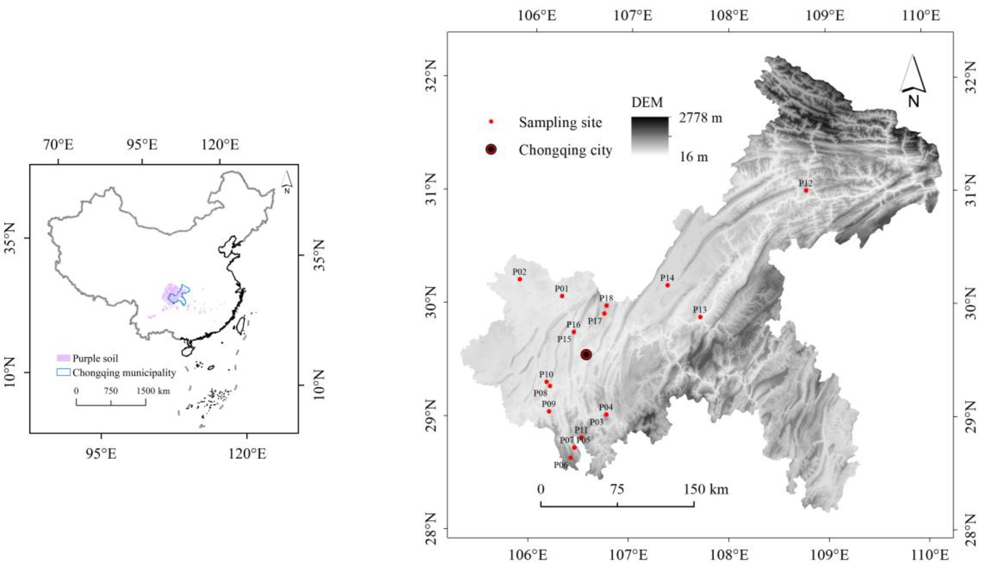
2.1. Study Area

The study area is located in the eastern section of the Sichuan Basin, which is located between 105°17′~110°11′ E, 28°10′~32°13′ N (Figure 1). The study area is situated at the junction of the more developed eastern region and the resource-rich western region. It is considered to be one of the important agricultural production areas in China, with rich and diverse land use types and high degrees of agricultural cultivated land development. The purple soil was mainly distributed in the hilly areas and the parallel ridge valley areas. The study area has the characteristics of a subtropical humid monsoon climate, with an average annual temperature range of between 16 °C and 18 °C. The average annual precipitation is relatively rich, with the majority of the areas in the range of 1000 to 1350 mm. The geographical distribution of precipitation is generally characterized by less in the west and more in the east, with the annual precipitation of relatively rainy areas in the southeast and northeast exceeding 1200 mm, and the annual precipitation of relatively less rainy areas in the west and central is 1000–1150 mm. In addition, precipitation is also influenced by the local topography, which usually tends to increase with the increase in altitude. For example, in the northeast region of Chongqing, precipitation in areas above 2100 m above sea level can reach more than 1500 mm [34]. The average annual relative humidity ranges between 70% and 80%, which makes it one of China’s high-humidity areas. The annual sunshine duration is between 1000 and 1400 h. However, the sunshine percentage is only 25% to 35%, which makes it one of the areas in China with the least amount of sunshine.

2.2. Soil Sampling Processes

During the second soil survey of Sichuan Province, a large number of purple soil profiles were recorded and classified using the SGCC [35]. Therefore, the legacy data of the surveys helped to provide reliable information regarding the typical soil types and soil genesis of the region. In accordance with the parent material and topography, 18 profiles distributed in the sampling area were chosen to represent the typical purple soil of the region (Figure 1, Table 1). The 18 representative pedons for this study were mainly distributed in hilly and low mountain areas and the elevation range of the pedons was between 224 and 1027 m. There were seven pedons from the hilly areas and eleven pedons from the low mountain areas. The representative pedons we selected were distributed at different slope positions. With the exception of the plot where P14 was the sloped terrace, the sampling plots of the other 17 pedons were natural slopes. The parent materials of the soil were the weathering material of sandstone, mudstone, shale, and other sedimentary rock developed during the Cretaceous, Jurassic, and Triassic periods of the Mesozoic. The mean annual precipitation levels of the tested soils ranged from 976 mm to 1196 mm, and the mean annual temperature range was 13.7 °C to 18.7 °C as detailed in Table 1. Except for P01, whose soil moisture regime was “Aquic”, the soil moisture regimes of the remaining 17 typical pedons were “Udic”.
The pedons were excavated according to the “Field Book for Describing and Sampling Soil” [36]. The pedomorphological features were described in terms of horizons, structures, consistency, HCl effervescence, and so on. Then, the horizons of the representative profiles were assigned (Figure 2); the soil samples were mainly Ap horizons (‘p’ meaning the influences of cultivation) or Ah horizons (‘h’ meaning humus accumulations); Bw horizons (‘w’ meaning weak coloration or structures within B) or Bt horizons (‘t’ meaning illuvial accumulations of silicate clay); and C horizons or Cr horizons (‘r’ meaning weathered or soft bedrock). The soil samples were collected according to the horizon designations and quickly transported back to this study’s laboratory facilities for air drying, the removal of plant debris, and grinding and sieving processes.

2.3. Laboratory Methods

The soil samples collected by horizons were promptly transported back to the laboratory for air-drying and the removal of impurities such as larger gravel and plant roots. Then, the samples were ground and sieved (2 mm) for physical and chemical analysis [37,38,39]. The soil color was evaluated using the Munsell soil color charts [40]. The soil pH levels were measured in 1:1 (weight: volume) soil: water [39]. In addition, the particle-size distributions were determined using sieving and sedimentation pipette methods [41]. The soil organic carbon (SOC) was measured using a potassium dichromate oxidation method, and the cation exchange capacity (CEC) was determined by the NH4OAc-EDTA exchange method at a suitable pH value (acid and neutral soils, at a pH of 7.0; calcareous soil, at a pH of 8.5) [38]. The content levels of exchangeable bases (Ca2+, Mg2+, Na+, and K+) were determined using NH4OAc -EDTA at a pH of 7.0 [42]. The base saturation is the ratio of base exchange capacity to cation exchange capacity (pH < 7; pH > 7, it is usually considered to be saturated). The calcium carbonate equivalent was determined by the gas volume method, and the free iron oxide was determined by the DCB-phenanthroline colorimetric method [43]. Finally, the representative profiles were classified according to the classification principles of the ST and WRB systems, and the reference between ST, the WRB, and the CST was established for purple soils at the level of the subgroup or secondary classification unit. The classification results of the tested soils in different systems were determined according to the “World Reference Base for Soil Resources 2022” [21], “Keys to Soil Taxonomy (13th edition)” [17], and “Keys to Chinese Soil Taxonomy, 3rd ed” [32].

3. Results

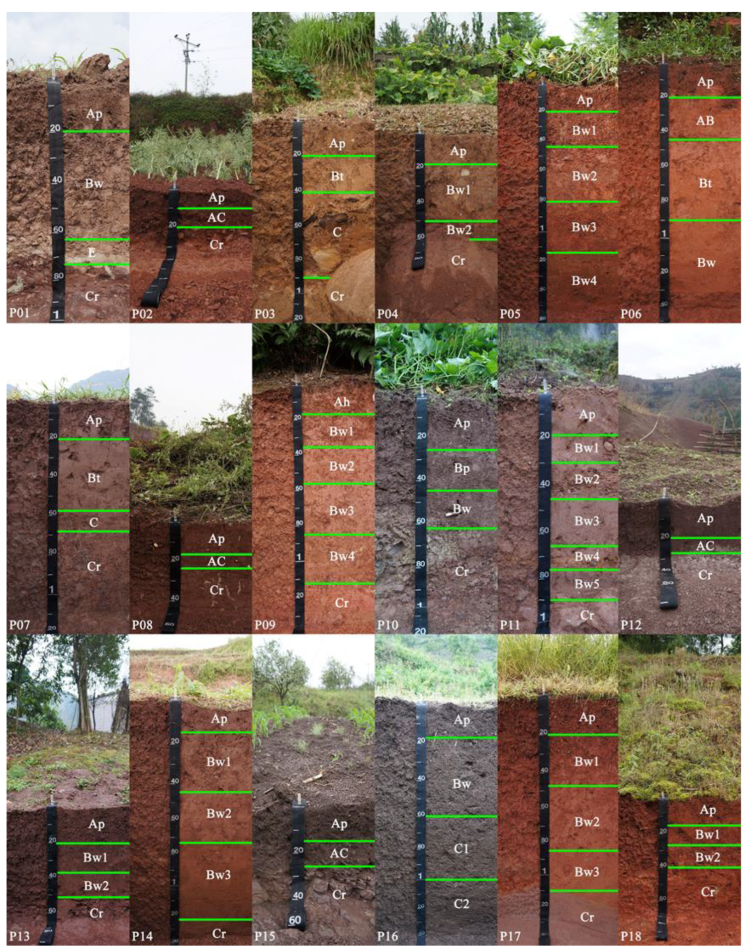
3.1. Profile Morphological Characteristics

The morphological characteristics of the soil profiles are an external expression of the soil formation process and an indispensable tool for identifying soil types. The morphological characteristics of the representative profiles varied with elevation, topography, parent rock, and other factors as detailed in Table 2. Within the depth range of 125 cm, it was observed that the pedons were characterized with A/B/(C)/(Cr) and A/(AC or C)/Cr horizon sequences. Then, with the 63 to 75 cm soil horizon in P01, the relevant conditions of ablic horizons were met, as expressed by E. The soil hues (dry/moist) of the tested pedons were 7.5R, 10R, 2.5YR, 5YR, 7.5YR, and 2.5Y. Some of the pedons were greatly influenced by the soil-forming environment, and their hues were found to be significantly different from the parent rock. For example, although the parent rock hue of the P01 sample was 5R, due to the influencing effects of the terrain, the hue of the soil changed significantly. In addition, the field observation results revealed that there were different amounts of a few fine dark accumulations (iron and manganese oxides) in the P01, P03, P09, P11, and P14 samples. The soil structure of the tested profiles was mainly angular or subangular blocky structures. Some profiles such as P02, P03, and P06 were affected by the soil texture, and the surface horizon was a granular structure. The profiles of P02, P08, P13, P14, P15, P16, and P18 showed varying degrees of lime reaction in their respective pedons. In addition, there was obvious clay film observed in the P03, P06, and P07 samples. In the surface horizon of the P10 sample, there were quantities of earthworm dung and earthworms with spacings less than 10 cm, as well as small amounts of brick debris and other human intrusions.

3.2. Physical and Chemical Properties

The physical and chemical properties of the representative pedons are listed in Table 3. The clay content of the B horizon ranged from 79 g·kg−1 in the Bw1 horizon of pedon P11 to 530 g·kg−1 in the Bw3 horizon of pedon P14. The content levels of clay in the B horizons of pedons P05, P07, and P09 were found to be high. The changes in the clay content in the Bw horizons of the different pedons may have been caused by the differences in the parent materials. The texture of those soils developed in mudstone varied greatly mainly due to the different densities and consolidation degrees of the mudstone. However, the textures of the majority of the purple soil were mainly loam and clay loam.
In the current investigation, the pH values of the tested soil varied from 4.3 to 8.9. The lowest and highest values appeared in the Bw4 horizon of P05 and the AC horizon of P02, respectively. In addition to the nature of the parent rock of the soil itself, the rainfall and humidity gradually increased with the increases in altitude in the humid mountainous areas. As a result, the rock and soil experienced leaching by rain for many years, resulting in the acidification and yellowing trend of the soil developed by the purple rock. In addition, human cultivation activities also aggravated the acidification of the soil to different degrees. The CaCO3 equivalent content of the tested soils ranged from 0.80 to 135.95 g·kg−1, which varied significantly among the different tested pedons, but the correlation with soil pH was found to be high, and the CaCO3 equivalent was higher in the tested soil pedons with higher pH values. The soil organic carbon content levels were found to range from 1.33 to 19.82 g·kg−1. Under the dual effects of man-made cultivation and biological natural accumulation, the surface horizon was found to contain higher organic carbon than the subsurface horizons. The observed general trend was that the content levels of the soil organic carbon gradually decreased from top to bottom. The content levels of organic carbon in the bottom horizon of P01, P06, P07, P09, and P17 were less than one-third of that observed in the surface horizon. These findings indicated that the natural conditions of the purple soil were rich in water and heat, and the biological cycle was particularly vigorous. Therefore, the formation process of organic matter was very rapid. The CEC value was between 6.43 and 46.35 cmol·kg−1. The CEC of P01, P07, P09, P15, and P16 was found to be higher than 30 cmol·kg−1, which may have been related to the higher content levels of soil organic carbon and clay. The base saturation of all the layers in profiles P05 and P09 was less than 50%, and that of some or all of the layers in the other soil profiles was more than 50%, which indicated base saturation (Table 3). The free iron oxide content of the test soil ranged from 6.04 to 50.14 g·kg−1 with a mean value of 22.38 g·kg−1. In addition, more information on the physical and chemical properties of the tested soils is provided in the Appendix A (Table A1).

3.3. Soil Classifications

The diagnostic horizons and diagnostic characteristics for the tested soil were determined according to the “Keys to Soil Taxonomy (13th edition)” [17]. The soil was attributed and named in the ST system level by level. The 18 pedons were divided into three soil orders; three soil suborders; four soil great groups; and seven soil subgroups in ST. The P03, P06, and P07 pedons were classified as Alfisols because of their obvious argillic horizons and saturated bases. Since the base saturation of P06 was lower than 60%, it was classified as Ultic Hapludalfs. The other two pedons had no other obvious diagnostic features and were classified as Typic Hapludalfs. For P01, P04, P05, P09, P10, P11, P13, P14, P16, P17, and P18, only the cambic horizons were diagnosed. These were classified as Inceptisols. In addition, in all the horizons within 60 cm of the mineral soil surface, the P01 pedon was found to have redox depletions with a chroma of 2 and also aquic conditions for some time during normal years, thereby fitting the classification characteristics of Aquic Eutrudepts. The P11 and P16 pedons were found to display texture classes of coarse sand or sand in all the horizons within 50 cm of the mineral soil surface and were classified as Arenic Eutrudeps. There were no other obvious diagnostic features observed in the P13, P14, and P18 pedons, except for the fact that only the soil base saturation levels were more than 60%. Therefore, those pedons were classified as Typic Eutrudepts. The base saturation levels of the soil layers for the P04, P05, P09, P10, and P17 pedons were determined to be less than 60%, and they were classified as Typic Dystrudepts. Finally, it was found that the P02, P08, P12, and P15 pedons had little or no evidence of horizon development, and they were all classified as Typic Udorthents.
In regard to the WRB system, according to the “World Reference Base for Soil Resources 2022” [21], the 18 pedons were classified as 4 RSGs: Anthrosols, Luvisols, Cambisols, and Regosols. However, in the secondary units, each section had its own series of principal and supplementary qualifications. Among those, the principal qualifications were mainly leptic, skeletic, dystric/eutric, and so on, and the supplementary qualifications were mainly aric, loamic, ochric, ferric, and so on.
In the current study, in accordance with the method of CST, the 18 profiles of purple soil from Chongqing were divided into four soil orders (Anthrosols, Argosols, Cambosols, and Primosols); six suborders; ten soil groups; and fifteen subgroups [33]. In addition, with the exception of the P10 pedon, where there were no man-made soil order in ST, the three classification systems did not correspond. However, the other profiles were found to be in good agreement with each other at the soil order level or the first level, as detailed in Table 4.

4. Discussion

4.1. Factors Affecting the ST Classifications of the Purple Soil

Generally speaking, the purple soil was mainly classified as Inceptisols or Entisols in ST, which was consistent with previous research results [44]. However, in this study, it was also found that some of the purple soil profiles distributed at higher altitudes were diagnosed as argillic horizons and classified as Alfisols. In this paper, combined with the soil-forming process of purple soils, we will discuss the influence of soil-forming factors such as topography, elevation, and parent materials on the classification attribution of purple soils in ST.
The topography of the purple soil distribution areas had obvious fluctuations, and the topography and altitude levels had major influencing effects on the local climate conditions. The soil properties were more significantly affected by natural factors in the higher altitude areas, and the purple parent material has little influence on the soil formation process [45]. Moreover, it was very clear that there was a relationship between the moisture regimes of the mountain soil and the topography and altitude levels of the region. The purple soil distributed in the mountainous areas at higher elevations experienced wetting and drying cycles more frequently, which made the soil more prone to leaching and the deposition of clay particles. For example, a certain amount of clay film could be observed on the surfaces of the soil structures of P03, P06, and P07, whose elevations were all above 600 m. Therefore, they were classified as Alfisols.
The characteristics of the topography also affected the development and depth of the purple soil, which was also obvious in ST. For example, the P02, P08, P12, and P15 pedons, which were located on summits or shoulders, were classified as Entisols. The developmental process of P01 was also influenced by the topography greatly. Due to the influencing effects of the terrain, the soil above the Cr horizon easily formed through stagnant water and side infiltration. This led to reductions in the iron content of the soil, resulting in the formation of an albic horizon. Many previous related studies showed that, under the influencing effects of high temperatures, rainy subtropical climate conditions, and strong human activity, soil and water losses were serious in low mountain and hilly areas containing purple soil [46]. In addition, parent rock continued to disintegrate during the process of purple soil formation. The very high levels of gravel or rock debris in the soil resulted in the purple soil development being shallow and thin, with A-C (AC) horizon sequences [47]. However, in the lower sections, such as the back slopes and foot slopes, the terrain sloped more gently. The sufficient water conditions and strong erosion resistance in those areas made soil loss more difficult. At the same time, soil erosion occurred in the summits and shoulders of the low hills and mountains and accumulated there. The purple soil located in the lower terrain had basically developed into A-Bw-(C)-(Cr) horizon sequences, which were attributed to Inceptisols. Therefore, the physical and chemical properties and profile patterns of the purple soil were significantly different under the action of topography, which affected its classification and attributions in the ST system.
As a lithologic soil, the physical and chemical properties of purple soils are profoundly influenced by the parent rock [2], which was reflected in the classification attribution in the ST system. The pH and salt saturation of the purple soils varied with the characteristics of the parent rock. The purple soils developed in mudstone of the Suining Formation (J3s) were found to have high carbonate content, an alkaline pH, and a lime reaction, and most of the pedons are classified as Typic Eutrudepts. The calcium carbonate of the purple soils developed in the sandstone of the Jiaguan Formation (K2j) was basically washed out by rainwater, the pH was acidic, and the salt base saturation of the soil in most of the profiles was less than 60%. Except for P12, the typical individuals of purple soils classified as Entisols were developed from pelitic rock. The parent rocks of this type are strongly physically weathered and weakly chemically weathered, resulting in very high gravel or rock debris content in the soils [33], and the profile level was not obviously developed, mostly in the A-C or Cr horizons sequences. It can be seen that the parent rock can affect the classification attribution of purple soils in ST from the aspects of profile development and physical and chemical properties.
In addition, vegetation and climate, especially precipitation, also have a great influence on the soil formation process of purple soils. In the areas with good natural vegetation growth, it was difficult for the rainwater to have strong erosion effects on the purple soil. In addition, during the development of the purple soil, large numbers of highly active clay particles were obtained from the weathering of the parent rock [35]. Therefore, vegetation and weather are also important factors influencing the classification of purple soils.

4.2. Factors Affecting the WRB Classifications of the Purple Soil

In the WRB system, the purple soil was mainly classified as Cambisol or Regosol. Those results were found to be consistent with previous studies [48]. However, some pedons were also found to belong to Anthrosols and Luvisols. Furthermore, similar to the classification attribution in the ST system, the P03, P06, and P07 pedons were determined as having argic horizons and were classified as Luvisols. Human activities were observed to have wide and profound influencing effects on the soil, which made the formation speed, development degrees, and direction of the soil far beyond natural evolution processes. Therefore, human activity was considered to be one of the decisive factors for cultivated land soil development [30]. The P10 was classified as an Anthrosol for the following main reasons. Agricultural activities such as farming, fertilization, and irrigation continue to be carried out, and soil fertility is constantly improving. The available phosphorus content levels on the soil surfaces are very high, accompanied by large numbers of earthworm holes and a small amount of brick debris and other intrusions. Therefore, the purple soil was changed from the Cambisol to the Anthrosol reference soil group under the influencing effects of human activity. In addition, land development in Chongqing has a long history, and the degree of agricultural intensification is generally high. The development processes of the cultivated land show that the influences of natural factors have gradually weakened, while the imprint of artificial farming disturbances has become continuously deeper [34]. This led to the cultivation layers of the majority of the dry land soil layers exceeding 20 cm, and the supplementary qualifiers of cultivated land (aric) were retrieved [20].
Similarly, the great influence of parent rock and topography on the profile development and physical and chemical properties of purple soils was also reflected in the WRB system. Purple rock strata are mainly distributed in low mountain and hilly areas. The anti-erodibility of purple parent material tends to be weak and soil erosion may be serious [49]. It is generally easy for surface erosion and gully erosion to occur during rainy summer seasons [50]. The purple soil distributed on the upper slopes and the tops of the slopes in hilly areas tends to experience more serious erosion. The topsoil is constantly eroded year after year, and new rocks are often exposed, forming shallow soil with high gravel content [30]. Therefore, the main qualifiers, such as skeletic and leptic, were retrieved in the WRB system. The pH and base saturation levels of the purple soil were found to vary with the characteristics of the parent rock [2]. The pH of the purple soil developed in the mudstone of the Suining Formation (J3s) was determined to be alkaline with lime reactions. Therefore, the principal qualifier “Calcaric” was allocated to the P02, P13, and P14 pedons. Meanwhile, the pH of the purple soil developed in the sandstone of the Jiaguan Formation (K2j) was acidic with an unsaturated base. Such a principal qualifier as dystric was allocated to the P03, P04, P05, and P06 pedons. In addition, in the purple soil hilly areas, the micro-topography was found to also affect the leaching of the soil base ions. The leaching of the purple soil from the top to the bottom of the slopes gradually increased, and its carbonate content gradually decreased [51].

4.3. Classification Characteristics of the Purple Soil in the Different Classification Systems

Although the ST and CST systems both employ a key, the soil temperature regimes, and soil moisture regimes were taken into consideration, and the classification names at the order level corresponded almost exactly to each other, the classification names at the subgroup level were found to vary greatly. The reasons for this are as follows. First, the CST system classified the perudic soil moisture regimes as a suborder. In addition, although the ST system also included the concept of perudic soil moisture regimes, it was not reflected in the suborders [16]. This may have been due to the geographical differences between the two countries. Second, the CST system was established under the guidance of the Chinese soil genetic theory. There were more diagnostic characteristics suitable for purple soil classifications in the soil groups and subgroups of the CST, such as the lithologic characters of the purplish sandstone and shale, ferric properties, and the color characteristics of the soil, which also resulted in different subgroup color categories, such as yellow and red. Therefore, the CST system had a stronger ability to distinguish purple soil than the ST system in lower classification units.
Similarly, when compared with the ST system, this study found that the WRB system displayed a stronger ability to distinguish purple soil, which was mainly reflected in the following aspects: 1. The climate-related soil moisture regimes were generally used to distinguish the suborders in ST. It was found that with the exception of the P02 pedon, which was an aquic soil moisture regime, the soil moisture status of the other pedons was udic soil moisture regimes. Therefore, there were no divisions in the suborders. 2. The WRB system had more diagnostic features, which resulted in the purple soil having greater differentiation in the secondary classification units. For example, there was no concept of lithic or paralithic contact in the WRB, and leptic was used to represent soil profiles with continuous rock material starting at ≤100 cm from the soil surface, which is very common in purple soil with shallow soil horizons. In addition, since purple soil is mainly developed from the parent rock of the “red layers”, the content levels of iron in the majority of the pedons were very high, with obvious red coloration. Therefore, the WRB system determined that chromic or ferric qualifiers could be diagnosed. In addition, when compared with the ST and CST systems’ fixed naming formats, the number of secondary unit qualifiers of the WRB system could be increased or decreased with the number of diagnostic characteristics of the soil profiles.
The first level of the WRB system, as well as the name of the soil order of the CST system, completely corresponded to the classification of purple soil. For example, both of the two classification systems had the Anthrosol RSG or order, and the WRB System’s Anthrosol RSG was actually based on the Chinese Anthrosol order. However, the classification names for the various purple soils in the WRB and CST differed in the lower classification units. The main reason for this was that the majority of the indicators used for classification in the WRB could be directly obtained in the field, such as the soil thicknesses, lime reactions, gravel content levels, and so on. Meanwhile, the CST system was more dependent on laboratory data. In comparison, the indicators needed for the WRB classification system can be obtained more quickly and easily, which will save time and material resources. In addition, when compared with the ST and CST systems’ fixed naming formats, the number of secondary unit qualifiers of the WRB system could be increased or decreased with the number of diagnostic characteristics of the soil profiles.
This study found that the purple soil tended to have its own characteristics in each classification system. However, its higher categories, particularly soil order, were the same or close in each of the examined systems. In the lower classification units, the lime reactions or salt saturation characteristics were used to diagnose the soil names, which indicated that the classification of purple soil tended to be unified in international communications. In addition, it was found that the WRB and CST systems paid more attention to the impacts of human activity on the soil classifications when compared with the ST system, and both had the Anthrosol RSG or orders. Furthermore, the WRB and CST systems displayed a greater ability to differentiate purple soils because they have more diagnostic characteristics.

5. Conclusions

In this study, the classification and reference of purple soil in ST and the WRB were discussed. In accordance with the principles and methods of the ST and the WRB, 18 typical purple soil pedons in the eastern Sichuan Basin were classified into three soil orders, three soil suborders, four soil great groups, and seven soil subgroups in ST, while they were sorted into four RSGs in the WRB; finally, each profile had its own series of principal and supplementary qualifiers in the secondary units. It was observed in this study that the purple soil had not only its own characteristics in each classification system but also had similar parts in different classification systems. When compared with the ST system, the WRB and CST systems displayed stronger abilities to distinguish purple soil. Both of the two systems paid more attention to the impacts of human activity and had set the Anthrosol RSG or order. Also, the WRB had more comprehensively considered soil characteristics such as leptic, ferric, chromic, and aric using principal and supplementary qualifiers. The CST had increased lithologic characters of purplish sandstones and shales, ferric properties, and alic properties at the soil great group and subgroup levels. However, at the level of soil order or RSG, the classification in different systems basically corresponded to one another, and some of the diagnostic indicators were similar, which indicates that the soil classification of purple soil is gradually tending to be unified in international exchange.

Author Contributions

Conceptualization, S.L. and Q.M.; Methodology, E.C.; Software, J.H. and Y.C.; Validation, J.H. and J.L.; Formal analysis, Y.C., S.L. and Q.M.; Investigation, Q.M. and E.C.; Resources, B.L.; Data curation, B.L., S.L., Q.M. and J.L.; Writing—original draft, S.L.; Writing—review & editing, Q.M. All authors have read and agreed to the published version of the manuscript.

Funding

This research was funded by the Fundamental Research Funds for the Central Universities (No. XDJK2020B069).

Data Availability Statement

Data are contained within the article.

Conflicts of Interest

The authors declare no conflict of interest.

Appendix A

Table A1. Some physical and chemical characteristics of the tested soils.
Pedon
No.
Depth (cm)TN (g·kg−1)TP (g·kg−1)TK (g·kg−1)AP (mg/kg)
P010–200.530.6617.6943.51
20–630.700.6217.8614.31
63–750.320.1814.704.53
P020–100.510.1518.791.39
10–200.410.7219.822.65
P030–200.820.6813.7718.46
20–400.820.3914.661.26
40–950.800.2512.750.75
P040–180.720.5514.4131.27
18–500.520.3514.5927.56
50–600.690.3315.5915.33
P050–201.000.3610.247.79
20–440.650.2411.363.18
44–800.540.1510.464.88
80–1160.740.1511.4712.71
116–1520.660.159.226.33
P060–201.110.1412.889.20
20–450.320.0713.434.58
45–900.350.0416.934.30
90–1400.210.0315.735.51
P070–200.930.2124.7215.69
20–580.660.1824.385.66
58–680.410.2424.822.27
P080–181.100.5118.516.81
18–230.740.5018.105.57
P090–180.330.2120.541.67
18–370.320.2420.681.72
37–570.370.1221.141.03
57–850.320.2920.341.97
85–1120.390.1121.750.78
P100–251.070.8528.07132.49
25–450.640.6527.90149.46
45–620.700.6126.4573.39
P110–190.920.219.0520.69
19–300.670.129.582.60
30–450.650.129.042.60
45–650.620.1310.814.47
65–760.550.149.833.22
76–900.720.1610.733.79
P120–200.640.8023.3624.37
20–280.620.7024.1822.86
P130–200.790.7118.5511.97
20–380.550.279.874.37
38–510.410.5517.714.05
P140–160.780.8622.9536.77
16–440.570.5722.936.40
44–730.440.5524.617.43
73–1220.420.2123.974.76
122–1380.380.2723.862.39
P150–151.042.2620.3018.62
15–241.001.5319.446.02
P160–181.161.6019.0922.12
18–600.881.1519.408.48
60–1000.701.0619.7611.94
100–1400.670.8619.598.67
P170–200.930.4618.7626.40
20–480.640.4218.0313.95
48–860.470.2117.827.77
86–1100.310.0812.698.72
P180–170.620.5426.045.91
17–280.490.4225.204.17
28–400.380.3226.413.25
TN = total nitrogen; TP = total phosphorus; TK = total K (potassium); AP = available phosphorus.

References

  1. National Soil Survey Staff. Soils of China; Chinese Agriculture Press: Beijing, China, 1998. (In Chinese) [Google Scholar]
  2. Zhong, S.; Han, Z.; Du, J.; Ci, E.; Ni, J.; Xie, D.; Wei, C. Relationships between the lithology of purple rocks and the pedogenesis of purple soils in the Sichuan Basin, China. Sci. Rep. 2019, 9, 13272. [Google Scholar] [CrossRef] [PubMed]
  3. Qing, C.; Mou, S.; Wang, D.; Wei, C.; Li, H.; Wang, Z.; Zhu, B.; Shi, X.; Xie, D.; Pu, F. More insights into purple soil (I) parent material: Redbeds. J. Southwest Univ. Nat. Sci. Ed. 2009, 31, 120–125. (In Chinese) [Google Scholar]
  4. Du, J.; Luo, Y.; Zhang, W.; Xu, C.; Wei, C. Major element geochemistry of purple soils/rocks in the red Sichuan Basin, China: Implications of their diagenesis and pedogenesis. Environ. Earth Sci. 2013, 69, 1831–1844. [Google Scholar] [CrossRef]
  5. Wei, C.; Ni, J.; Gao, M.; Xie, D.; Hasegawa, S. Anthropic pedogenesis of purple rock fragments in Sichuan Basin, China. Catena 2006, 68, 51–58. [Google Scholar] [CrossRef]
  6. Zhu, X.; Zhu, B. Diversity and abundance of soil fauna as influenced by long-term fertilization in cropland of purple soil, China. Soil Tillage Res. 2015, 146, 39–46. [Google Scholar] [CrossRef]
  7. Khan, M.; Gong, Y.; Hu, T.; Lal, R.; Zheng, J.; Justine, M.; Azhar, M.; Che, M.; Zhang, H. Effect of Slope, Rainfall Intensity and Mulch on Erosion and Infiltration under Simulated Rain on Purple Soil of South-Western Sichuan Province, China. Water 2016, 8, 528. [Google Scholar] [CrossRef]
  8. Li, Z.; Wang, P.; Liu, L.; Zheng, Y.; Xie, D. High negative surface charge increases the acidification risk of purple soil in China. Catena 2021, 196, 104819. [Google Scholar] [CrossRef]
  9. Mou, S.; Qing, C.; Duan, W.; Wei, C.; Wang, D.; Li, H.; Zhu, B.; Pu, F.; Xie, D. More insights into purple soil (II)-global purple soil. J. Southwest Univ. Nat. Sci. Ed. 2009, 31, 126–130. (In Chinese) [Google Scholar]
  10. Hartemink, A.E. The use of soil classification in journal papers between 1975 and 2014. Geoderma Reg. 2015, 5, 127–139. [Google Scholar] [CrossRef]
  11. Crocker, R.L. Soil Genesis and the Pedogenic Factors. Q. Rev. Biol. 1952, 27, 139–168. [Google Scholar] [CrossRef]
  12. Bockheim, J.G.; Gennadiyev, A.N.; Hammer, R.D.; Tandarich, J.P. Historical development of key concepts in pedology. Geoderma 2005, 124, 23–36. [Google Scholar] [CrossRef]
  13. Morand, D.T. The World Reference Base for Soils (WRB) and Soil Taxonomy: An appraisal of their application to the soils of the Northern Rivers of New South Wales. Soil Res. 2013, 51, 167. [Google Scholar] [CrossRef]
  14. Bockheim, J.G. Soil Geography of the USA; Springer International Publishing: Cham, Switzerland, 2014. [Google Scholar] [CrossRef]
  15. Soil Survey Staff. Soil Taxonomy: A Basic System of Soil Classification for Making and Interpreting Soil Survey; U.S. Department of Agriculture Handbook; Government Printing Office: Washington, DC, USA, 1975. [Google Scholar]
  16. Soil Survey Staff. Soil Taxonomy: A Basic System of Soil Classification for Making and Interpreting Soil Surveys, 2nd ed.; Natural Resources Conservation Service, U.S. Department of Agriculture Handbook 436; Government Printing Office: Washington, DC, USA, 1999. [Google Scholar]
  17. Soil Survey Staff. Keys to Soil Taxonomy, 13th ed.; USDA-Natural Resources Conservation Service: Washington, DC, USA, 2022. [Google Scholar]
  18. IUSS Working Group WRB. World Reference Base for Soil Resources (No. World Soil Resources Reports 84); FAO: Rome, Italy, 1998. [Google Scholar]
  19. IUSS Working Group WRB. World Reference Base for Soil Resources 2006 (No. World Soil Resources Report 103); FAO: Rome, Italy, 2006. [Google Scholar]
  20. IUSS Working Group WRB. World Reference Base for Soil Resources 2014. International Soil Classification System for Naming Soils and Creating Legends for Soil Maps; Update 2015 (No. World Soil Resources Report 106); FAO: Rome, Italy, 2015. [Google Scholar]
  21. IUSS Working Group WRB. World Reference Base for Soil Resources. International Soil Classification System for Naming Soils and Creating Legends for Soil Maps, 4th ed.; International Union of Soil Sciences (IUSS): Vienna, Austria, 2022. [Google Scholar]
  22. Dazzi, C.; Monteleone, S. Anthropogenic processes in the evolution of a soil chronosequence on marly-limestone substrata in an Italian Mediterranean environment. Geoderma 2007, 141, 201–209. [Google Scholar] [CrossRef]
  23. Rossiter, D.G. Classification of Urban and Industrial Soils in the World Reference Base for Soil Resources (5 pp). J. Soils Sediments 2007, 7, 96–100. [Google Scholar] [CrossRef]
  24. Esfandiarpour, I.; Salehi, M.H.; Karimi, A.; Kamali, A. Correlation between Soil Taxonomy and World Reference Base for Soil Resources in classifying calcareous soils: A case study of arid and semi-arid regions of Iran. Geoderma 2013, 197–198, 126–136. [Google Scholar] [CrossRef]
  25. Sarmast, M.; Farpoor, M.H.; Esfandiarpour Boroujeni, I. Comparing Soil Taxonomy (2014) and updated WRB (2015) for describing calcareous and gypsiferous soils, Central Iran. Catena 2016, 145, 83–91. [Google Scholar] [CrossRef]
  26. Gong, Z.T.; Chen, Z.C.; Zhang, G.L. World reference base for soil resources (WRB): Establishment and development. Soils 2003, 35, 271–278. (In Chinese) [Google Scholar]
  27. Esfandiarpour, I.; Mosleh, Z.; Farpoor, M.H. Comparing the ability of Soil Taxonomy (2014) and WRB (2015) to distinguish lithologic discontinuity and an abrupt textural change in major soils of Iran. Catena 2018, 165, 63–71. [Google Scholar] [CrossRef]
  28. Kaba£a, C.; Świtoniak, M.; Charzyński, P. Correlation between the Polish Soil Classification (2011) and international soil classification system World Reference Base for Soil Resources (2015). Soil Sci. Annu. 2016, 67, 88–100. [Google Scholar] [CrossRef]
  29. Salehi, M.H. Challenges of Soil Taxonomy and WRB in classifying soils: Some examples from Iranian soils. Phys. Geogr. Ser. 2018, 14, 63–70. [Google Scholar] [CrossRef]
  30. He, X.; Bao, Y.; Nan, H.; Xiong, D.; Wang, L.; Liu, Y.; Zhao, J. Tillage pedogenesis of purple soils in southwestern China. J. Mt. Sci. 2009, 6, 205–210. [Google Scholar] [CrossRef]
  31. Throp, J. Geography of the Soils of China; The National Geography Survey of China: Nanjing, China, 1936. [Google Scholar]
  32. Chinese Soil Taxonomy Research Group. Keys to Chinese Soil Taxonomy, 3rd ed.; University of Science and Technology of China Press: Hefei, China, 2001. (In Chinese) [Google Scholar]
  33. Ci, E.; Tang, J.; Lian, M.; Chen, L.; Weng, H.; Fan, J.; Wei, C. Higher category partition for purples soil in Chongqing in Chinese Soil Taxonomy. Acta Pedol. Sin. 2018, 55, 569–584. (In Chinese) [Google Scholar]
  34. Ci, E. Soil Series of China, Chongqing; Science Press: Beijing, China, 2020. (In Chinese) [Google Scholar]
  35. Agriculture and Animal Husbandry Department of Sichuan Province; Soil Survey Office of Sichuan Province. Soils of Sichuan Province; Sichuan Science and Technology Press: Chengdu, China, 1997. (In Chinese)
  36. Schoeneberger, P.J.; Wysocki, D.A.; Benham, E.C. Soil Survey Staff. In Field Book for Describing and Sampling Soils, 3rd ed.; Natural Resources Conservation Service, National Soil Survey Center: Lincoln, NE, USA, 2012. [Google Scholar]
  37. Soil Survey Staff. Soil Survey Field and Laboratory Methods Manual, Soil Survey Investigations Report No. 51, Version 2.0.; Burt, R., Ed.; United States Department of Agriculture: Washington, DC, USA, 2014. [Google Scholar]
  38. Zhang, G.L.; Gong, Z.T. Soil Survey Laboratory Methods; Science Press: Beijing, China, 2012. (In Chinese) [Google Scholar]
  39. Lu, R.K. Analytical Method of Soil Agrochemistry; China Agricultural Science and Technology Press: Beijing, China, 2000. (In Chinese) [Google Scholar]
  40. Munsell. In Munsell Soil Color Charts; Gretag MacBeth: New Windsor, NY, USA, 2000.
  41. Whittig, L.D.; Allardice, W.R. X-ray diffraction techniques. In Methods of Soil Analysis—Part I. Physical and Mineralogical Methods; Klute, A., Ed.; Soil Science Society of America: Madison, WI, USA, 1986. [Google Scholar]
  42. Chapman, H.D. Cation exchange capacity. In Methods of Soil Analysis: Part 2; Black, C.A., Ed.; American Society of Agronomy: Madison, WI, USA, 1965; pp. 891–900. [Google Scholar]
  43. Yang, J.H.; Wang, C.L.; Dai, H.L. Soil Agrochemical Analysis and Environmental Monitoring; China Land Press: Beijing, China, 2008. (In Chinese) [Google Scholar]
  44. Shi, X.Z.; Yu, D.S.; Warner, E.D.; Sun, W.X.; Petersen, G.W.; Gong, Z.T.; Lin, H. Cross-Reference System for Translating Between Genetic Soil Classification of China and Soil Taxonomy. Soil Sci. Soc. Am. J. 2006, 70, 78–83. [Google Scholar] [CrossRef]
  45. Zeng, J.T. Study on the classification of purple soils. J. Southwest Univ. Nat. Sci. Ed. 1984, 1, 1–14. (In Chinese) [Google Scholar]
  46. Chen, X.; Huang, Y.; Zhao, Y.; Mo, B.; Mi, H. Comparison of loess and purple rill erosions measured with volume replacement method. J. Hydrol. 2015, 530, 476–483. [Google Scholar] [CrossRef]
  47. Soil Research Laboratory; Chengdu Branch; Chinese Academy of Sciences. Purple Soils of China; Science Press: Beijing, China, 1991. (In Chinese) [Google Scholar]
  48. Shi, X.Z.; Yu, D.S.; Xu, S.X.; Warner, E.D.; Wang, H.J.; Sun, W.X.; Zhao, Y.C.; Gong, Z.T. Cross-reference for relating Genetic Soil Classification of China with WRB at different scales. Geoderma 2010, 155, 344–350. [Google Scholar] [CrossRef]
  49. Stolte, J.; Shi, X.; Ritsema, C.J. Introduction: Soil erosion and nutrient losses in the Hilly Purple Soil area in China. Soil Tillage Res. 2009, 105, 283–284. [Google Scholar] [CrossRef]
  50. Xie, T.S. Chinese Purple Soil Hills; Hunan Science and Technology Press: Changsha, China, 2018. (In Chinese) [Google Scholar]
  51. Tan, M.X.; Liu, L.; Wang, P.S.; Cheng, Y.Y.; Xie, D.T.; Li, D.T. Effect of microtopography on the acidification characteristics of soils developed from purple parent rock. Acta Pedol. Sin. 2018, 55, 1441–1449. (In Chinese) [Google Scholar]
Figure 1. The distribution of purple soil sampling sites in the study area.
Agronomy 13 01837 g001
Figure 2. Images of the 18 representative purple soil profiles with horizon sequences. Ap, Ah, Bw, Bt, C, Cr, and E denote the Ap horizons, Ah horizons, Bw horizons, Bt horizons, C horizons, Cr horizons, and E horizons, respectively.
Agronomy 13 01837 g002
Table 1. Site characteristics of the 18 representative purple soil pedons.
Pedon
No.
LocationElevation (m)LithostratigraphyParent MaterialTerrainPositionMAP (mm)MAT (°C)SMR
P01Hechuan District254Shaximiao Formation (J2s)MudstoneHillyShoulder114017.7Aquic
P02Tongnan District270Suining Formation (J3s)MudstoneHillyShoulder97617.6Udic
P03Qijiang District688Jiaguan Formation (K2j)Sandstone and conglomerateMountainBack slope102017.4Udic
P04Qijiang District696Jiaguan Formation (K2j)SandstoneMountainBack slope102017.4Udic
P05Jiangjin District588Jiaguan Formation (K2j)Sandstone and mudstoneMountainFoot slope100016.4Udic
P06Jiangjin District1027Jiaguan Formation (K2j)SandstoneMountainShoulder100013.7Udic
P07Jiangjin District613Penglaizhen Formation (J3p)MudstoneMountainBack slope100016.2Udic
P08Jiangjin District286Ziliujing Formation (J1–2z)MudstoneHillySummit100018.1Udic
P09Jiangjin District280Shaximiao Formation (J2s)MudstoneHillyFoot slope100018.2Udic
P10Bishan District263Ziliujing Formation (J1–2z)MudstoneHillyFoot slope106418.4Udic
P11Qijiang District874Penglaizhen Formation (J3p)SandstoneMountainBack slope102016.3Udic
P12Yunyang County612Shaximiao Formation (J2s)Sandy mudstoneMountainShoulder110816.6Udic
P13Fengdu County224Suining Formation (J3s)Mudstone and siltstoneHillyBack slope101918.7Udic
P14Dianjiang County372Suining Formation (J3s)MudstoneHillyFoot slope119617.4Udic
P15Beibei District520Feixianguan Formation (T1f)Mud shaleMountainShoulder115716.5Udic
P16Beibei District515Feixianguan Formation (T1f)Mud shaleMountainFoot slope115716.6Udic
P17Yubei District585Shaximiao Formation (J2s)Sandstone and mudstoneMountainBack slope115616.4Udic
P18Yubei District736Shaximiao Formation (J2s)Mudstone and siltstoneMountainShoulder115615.5Udic
MAP = mean annual precipitation; MAT = mean annual temperature; SMR = soil moisture regime.
Table 2. Morphological characteristics of the 18 representative purple soil profiles a.
Pedon
No.
HorizonDepth (cm)BoundaryColorConsistencyStructureHCl Effervescence
DryMoistDryMoist
P01Ap0–20DS7.5YR 4/27.5YR 3/2SHFR1FSBKNE
Bw20–63GS7.5YR 4/27.5YR 3/2HAFI1COSBKNE
E63–75AS7.5YR 7/27.5YR 6/2HAFI1FSBKNE
Cr75+ 5R 5/25R 4/2 NE
P02Ap0–10DS10R 4/410R 3/4SHFRMGRVE
AC10–20AW10R 4/410R 3/4HAFI1MSBKVE
Cr20+ 10R 4/410R 3/4 VE
P03Ap0–20GS7.5YR 6/47.5YR 4/4SHFRCOGRNE
Bt20–40GS7.5YR 6/67.5YR 4/6HAFI2MSBKNE
C40–95AW7.5YR 6/67.5YR 4/6VHFI1MSBKNE
Cr95+ 7.5YR 8/27.5YR 7/2 NE
P04Ap0–18DS7.5YR 6/47.5YR 4/4SHFR1FSBKNE
Bw118–50GW7.5YR 7/47.5YR 5/4HAFI1MSBKNE
Bw250–60AW7.5YR 6/47.5YR 4/4HAFI1MSBKNE
Cr60+ 2.5YR 4/32.5YR 3/3 NE
P05Ap0–20DS2.5YR 6/62.5YR 4/6SHFR2FSBKNE
Bw120–44DS2.5YR 6/62.5YR 4/6HAFI2MSBKNE
Bw244–80DS2.5YR 5/62.5YR 4/6HAFI2MSBKNE
Bw380–116GS2.5YR 5/62.5YR 4/6VHFI2MSBKNE
Bw4116–152 2.5YR 6/62.5YR 4/6VHFI2MSBKNE
P06Ap0–20GS10R 5/310R 4/3SHFR2COGRNE
AB20–45DS10R 5/610R 4/6HAFI2MSBKNE
Bt45–90DS10R 5/610R 4/6HAFI2MSBKNE
Bw90–140 10R 5/610R 4/6VHVFI2MSBKNE
P07Ap0–20GS2.5YR 5/22.5YR 4/2SHFR1FSBKNE
Bt20–58GS2.5YR 5/22.5YR 4/2HAFI2COSBKNE
C58–68CS2.5YR 4/22.5YR 3/2VHVFI2MSBKSL
Cr68+ 2.5YR 4/22.5YR 3/2 SL
P08Ah0–18DS2.5YR 5/32.5YR 4/3SHFR2FSBKST
AC18–23CS2.5YR 5/32.5YR 4/3HAFI1MSBKST
Cr23+ 2.5YR 4/32.5YR 3/3 ST
P09Ah0–18DS10R 6/410R 5/4SHFR2MSBKNE
Bw118–37DS10R 6/410R 5/4HAFI2MSBKNE
Bw237–57DS10R 6/410R 5/4HAFI2MSBKNE
Bw357–85DS10R 6/410R 5/4VHFI2MSBKNE
Bw485–112AW10R 6/410R 5/4VHFI1MSBKNE
Cr112+ 10R 5/410R 4/4 NE
P10Ap0–25DS10R 5/210R 4/2SFR1FSBKNE
Bp25–45DS10R 5/210R 4/2SHFI1FSBKNE
Bw45–62AW10R 5/210R 4/2SHFI1FSBKNE
Cr62+ 10R 5/310R 4/3 NE
P11Ap0–19DS5YR 6/35YR 4/3SVFR2FSBKNE
Bw119–30GS5YR 6/45YR 4/3SHFR1MSBKNE
Bw230–45CS5YR 6/45YR 4/3SHFR1MSBKNE
Bw345–65GS5YR 6/35YR 4/3SHFR1MSBKNE
Bw465–76CS5YR 6/45YR 4/3HAFI1MSBKNE
Bw576–90AI5YR 6/45YR 4/3HAFI1MSBKNE
Cr90+ 5YR 6/45YR 4/3 NE
P12Ap0–20DS5R 5/12.5R 3/2SVFR1FGRNE
AC20–28AS5R 5/12.5R 3/2SHFR1FGRNE
Cr28–40 5R 4/12.5R 3/2 NE
P13Ap0–20DS7.5R 5/47.5R 4/4SHFR1FSBKVE
Bw120–38GS7.5R 5/47.5R 4/4SHFR1FSBKVE
Bw238–51AS7.5R 5/47.5R 4/4HAFI1MSBKVE
Cr51–64 7.5R 5/47.5R 4/4 VE
P14Ap0–16DS2.5YR 6/42.5YR 5/4SHFR1FSBKST
Bw116–44DS2.5YR 5/42.5YR 4/4HAFI1FSBKST
Bw244–73GW2.5YR 5/42.5YR 4/4HAFI1MSBKST
Bw373–122GW2.5YR 6/42.5YR 5/4HAFI2COSBKVS
C122–138 2.5YR 5/42.5YR 4/4HAFI1MSBKVS
P15Ap0–15DS10R 4/110R 3/1SHFR1FGRVS
AC15–24AW10R 4/110R 3/1SHFR1FGRVS
Cr24–48 10R 4/110R 3/1 ST
P16Ap0–18DS10R 4/110R 3/1SHFR1MGRVS
Bw18–60DS10R 4/110R 3/1HAFI1MGRVS
C160–100DS10R 4/110R 3/1HAFI1MGRVS
C2100–140 10R 4/110R 3/1HAFI1MGRVS
P17Ap0–20DS10R 6/410R 5/4SHFR2FSBKNE
Bw120–48DS10R 6/410R 5/4SHFR2FSBKNE
Bw248–86DS10R 6/410R 5/4HAFI1MSBKNE
Bw386–110DS10R 6/410R 5/4HAFI1MSBKNE
Cr110–140 10R 7/210R 6/2 NE
P18Ap0–17DS10R 5/610R 4/6SHFR1FSBKVS
Bw117–28DS10R 5/610R 4/6HAFI1MSBKVS
Bw228–40CW10R 5/610R 4/6HAFI1MSBKVS
Cr40–68 10R 4/610R 3/6 VS
a The symbols are used based on Schoeneberger et al. (2012) [36] as follows: horizon: Ap indicates a disturbance of a soil surface horizon by mechanical means, pasturing, or similar uses; Bw indicates the development of color or structure, or both, with little or no apparent illuvial accumulation of material. Cr indicates layers of bedrock that are moderately cemented or less cemented. Boundary: A = abrupt; C = clear; G = gradual; D = diffuse; S = smooth; W = wavy; I = irregular; dry consistency: S = soft; SH = slightly hard; HA = hard; VH = very hard; moist consistency: VFR = very friable; FR = friable; FI = firm; VFI = very firm; structure type: GR = granular; ABK = angular blocky; SBK = subangular blocky; structure grade: 1 = weak; 2 = moderate; structure size: F = fine; M = medium; CO = coarse; effervescence class: NE = non-effervescent; VS = very slightly effervescent; SL = slightly effervescent; ST = strongly effervescent; VE = violently effervescent.
Table 3. Physical and chemical characteristics of the 18 representative purple soil profiles.
Pedon
No.
Depth (cm)Sand (%)Silt (%)Clay (%)RFSoil TexturepHCaCO3 (g·kg−1)SOC (g·kg−1)CEC (cmol·kg−1)BSFree Iron Oxide (g·kg−1)
P010–2028.645.026.45L4.910.8416.8942.2642.5%10.22
20–6324.856.219.05SiL5.313.379.9446.3550.0%12.45
63–7542.533.124.415L6.322.733.7144.7966.0%6.04
P020–1072.318.98.875SL8.1133.402.9623.72-18.03
10–2068.822.68.675SL8.9135.952.6022.30-17.79
P030–2056.524.918.65SL5.14.6711.7912.3250.8%14.42
20–4047.127.125.87SCL5.74.558.8914.0060.3%21.90
40–9547.930.621.560L6.110.527.6314.2064.3%23.34
P040–1856.226.317.510SL5.03.7211.7310.8052.7%13.30
18–5054.823.022.235SCL5.34.377.1310.8953.5%12.84
50–6057.622.719.715SL5.13.2011.4111.5753.6%13.33
P050–2041.524.534.08CL4.40.8015.2815.6939.8%35.13
20–4438.624.237.25CL4.51.068.8515.6939.5%36.04
44–8039.324.336.42CL4.51.146.9713.4740.5%31.96
80–11636.829.533.72CL4.50.8611.5514.1140.7%33.81
116–15233.928.038.12CL4.30.9010.6917.5438.3%36.53
P060–2062.224.813.02SL5.63.6016.149.8758.6%9.26
20–4561.425.812.810SL5.92.014.589.9263.4%9.29
45–9037.645.516.9-L6.03.273.9911.9259.2%11.10
90–14048.339.512.2-L6.011.341.339.9258.6%10.48
P070–2017.846.435.85SiCL5.618.1514.9925.9457.0%12.67
20–5811.139.549.4-C7.318.988.7930.42-13.15
58–6850.328.920.860L8.351.384.9238.36-10.52
P080–1832.744.822.510L8.174.2217.8826.92-25.57
18–2332.748.119.250L8.487.8513.2731.71-27.25
P090–182.352.245.5-SiC4.56.399.4733.1716.8%32.58
18–373.656.639.8-SiC4.66.675.1331.4922.2%29.79
37–5710.954.834.3-SiCL4.66.983.0931.9023.0%28.72
57–8517.853.029.2-SiCL4.66.152.5632.0122.9%26.14
85–11215.056.528.5-SiCL4.67.342.8233.9824.7%26.76
P100–2540.545.713.830L6.09.9514.5022.1460.0%22.87
25–4546.041.212.840L5.48.548.1723.4052.3%23.45
45–6250.237.911.945L5.38.929.0022.2556.4%22.87
P110–1969.519.610.95SL5.32.3813.179.0453.1%9.04
19–3071.718.697.05SL5.62.306.667.1258.8%9.70
30–4572.019.78.315SL6.02.306.496.4369.3%8.91
45–6562.226.511.35SL6.12.806.779.5959.6%11.14
65–7675.516.67.915SL6.32.804.826.9164.1%11.81
76–9063.025.911.110SL6.73.228.238.1766.2%11.48
P120–2070.521.28.370SL6.618.7016.9419.9861.6%18.76
20–2865.924.110.070SL6.319.7512.5414.2166.5%16.51
P130–2051.933.514.615L8.371.619.4022.33-23.71
20–3848.237.913.915L8.482.174.3722.55-24.02
38–5154.835.39.9015L8.391.213.7020.32-22.81
P140–1625.255.419.410SiL8.571.6611.3033.07-21.30
16–4436.051.612.48SiL8.679.126.5927.90-20.31
44–7345.543.810.75L8.672.165.6428.64-21.91
73–1224.642.453.05SiC8.226.085.9237.79-26.12
122–13828.237.634.250CL8.220.584.9334.83-25.43
P150–1583.25.011.875LS8.253.2616.2937.73-45.98
15–2472.917.59.675SL8.451.2616.5740.28-46.06
P160–1866.217.915.935SL8.244.0129.8233.50-48.03
18–6066.117.916.040SL8.243.0119.0632.48-48.82
60–10065.318.516.255SL8.543.5515.0832.48-49.95
100–14052.623.623.860SCL8.033.5012.8739.11-50.14
P170–2036.043.720.32L5.110.2011.2822.5957.7%17.39
20–4833.448.018.63L5.49.378.2320.9259.9%20.54
48–8640.043.316.72L6.07.115.6823.3759.5%22.10
86–11039.538.222.32L5.34.863.7524.1750.5%25.40
P180–1723.854.621.610SiL7.615.269.7224.27-18.37
17–2828.352.719.015SiL8.114.096.1421.33-17.60
28–4028.353.018.720SiL7.915.785.5121.23-14.56
RF = rock fragments; SOC = soil organic carbon; CEC = cation exchange capacity; BS = base saturation. Note: the - in the BS column means that the pH value of the horizon is greater than 7 and the salt base is saturated.
Table 4. Classification attribution of the 18 representative purple soil pedons in different classification systems.
PedonSoil Classification
No.Soil Taxonomy (2022) (Subgroup)World Reference Base for Soil Resources (2022)Chinese Soil Taxonomy (2001) (Subgroup)
P01Aquic EutrudeptsEutric Stagnic Endoleptic Cambisols (Aric, Loamic, Ochric)Albic Hapli-Udic Cambosols
P02Typic UdorthentsCalcaric Skeletic Epileptic Regosols (Loamic)Lithic Udi-Orthic Primosols
P03Typic HapludalfsFerric Leptic Luvisols (Aric, Loamic, Ochric)Mottlic Ferri-Udic Argosols
P04Typic DystrudeptsDystric Leptic Cambisols (Loamic, Ochric)Typic Acidi-Udic Cambosols
P05Typic DystrudeptsDystric Chromic Cambisols (Aric, Loamic, Ochric)Typic Ali-Udic Cambosols
P06Ultic HapludalfsChromic Luvisols (Aric, Loamic, Ochric)Typic Hapli-Perudic Argosols
P07Typic HapludalfsCalcaric Leptic Luvisols (Aric, Clayic, Ochric)Red Ferri-Udic Argosols
P08Typic UdorthentsCalcaric Epileptic Regosols (Loamic, Ochric)Calcaric Purpli-Orthic Primosols
P09Typic DystrudeptsDystric Cambisols (Amphiloamic, Ochric)Mottlic Ali-Udic Cambosols
P10Typic DystrudeptsHortic Anthrosols (Eutric, Loamic, Leptic)Dystric Fimi-Orthic Anthrosols
P11Arenic EutrudeptsEutric Endoleptic Cambisols (Loamic, Ferric, Ochric)Ferric Hapli-Perudic Cambosols
P12Typic UdorthentsEutric Skeletic Apileptic Regosols (Aric, Loamic, Ochric)Typic Purpli-Orthic Primosols
P13Typic EutrudeptsCalcaric Endoleptic Cambisols (Aric, Loamic, Ferric, Ochric)Red Ferri-Udic Cambosols
P14Typic EutrudeptsCalcaric Cambisols (Geoabruptic, Ferric, Ochric)Red Ferri-Udic Cambosols
P15Typic UdorthentsCalaric Skeletic Epileptic Regosols (Ochric)Lithic Udi-Orthic Primosols
P16Arenic EutrudeptsCalcaric Skeletic Cambisols (Loamic, Humic)Typic Carbonati-Udic Cambosols
P17Typic DystrudeptsEutric Cambisols (Aric, Loamic, Ochric)Red Ferri-Udic Cambosols
P18Typic EutrudeptsCalcaric Chromic Cambisols (Loamic, Ochric)Red Ferri-Udic Cambosols
Disclaimer/Publisher’s Note: The statements, opinions and data contained in all publications are solely those of the individual author(s) and contributor(s) and not of MDPI and/or the editor(s). MDPI and/or the editor(s) disclaim responsibility for any injury to people or property resulting from any ideas, methods, instructions or products referred to in the content.

