Article

Bibliometric Analysis of Spatial Technology for World Heritage: Application, Trend and Potential Paths

1
International Research Center of Big Data for Sustainable Development Goals, Beijing 100094, China
2
Key Laboratory of Digital Earth Science, Aerospace Information Research Institute, Chinese Academy of Sciences, Beijing 100094, China
3
Laboratory for Earth Surface Processes, College of Urban and Environmental Sciences, Peking University, Beijing 100871, China
4
Zhengzhou Institute of Cultural Relics and Archaeology, Zhengzhou 450000, China
5
Department of Landscape Architecture, Central South University of Forestry and Technology, Changsha 410004, China
*
Author to whom correspondence should be addressed.
Remote Sens. 2023, 15(19), 4695; https://doi.org/10.3390/rs15194695
Submission received: 30 July 2023 / Revised: 15 September 2023 / Accepted: 18 September 2023 / Published: 25 September 2023

Abstract

:
World heritage sites are monuments and natural landscapes recognised by all humanity as being of outstanding significance and universal value. Spatial technology provides new ideas for the conservation and sustainable development of world heritage sites. Using a bibliometric analysis, this study extracted 401 relevant documents from the Web of Science database from 1990–2022. Meta information, such as abstracts, keywords of the papers were extracted and cleaned using bibliometric package and analysed the applications, partnerships and development trends of existing spatial technologies for world heritage sites. The results of the study show the “4D” characteristics of space technology in world heritage sites: (1) Development: Spatial applications in world heritage sites have gradually developed with an annual growth rate of 10.22% during the period 1990–2022. (2) Discrepancy: More than 70 per cent of countries have not been able to fully apply space technology on the ground at world heritage sites. (3) Desirability: Shared exchanges between research institutions are rare, and more cooperation and exchanges are expected, especially between transnationals. (4) Diversity: The future outlook for technology will be multidisciplinary, multi-method integrated research.

1. Introduction

The Sustainable Development Goals (SDGs) are a universal call to action to end poverty, protect the planet and ensure that all people enjoy peace and prosperity [1]. In 17 SDGs, SDG11.4 is proposed to further promote the efforts to protect and safeguard the world’s cultural and natural heritage [2]. World heritage sites (WHs) are places of exceptional cultural and natural value that are recognized by the United Nations Educational, Scientific and Cultural Organization (UNESCO). These sites reflect the diversity of the world’s natural and cultural heritage and are considered to be of ‘outstanding universal value’ [3]. WHs have both natural and cultural attributes, which means we can combine spatial technology with archaeological excavation surveys to build comprehensive database [4,5]. The inclusion of spatial technology provides a new window for the conservation and development of WHs, especially for SDG11.4.
Spatial technology, such as GIS (Geographic Information System) and RS (remote sensing), plays a crucial role in the management and preservation of WHs [6,7,8,9,10,11]. These technologies enable the collection, analysis and visualization of data related to the physical and cultural characteristics of heritage sites [12,13,14,15]. This information can be used for a variety of purposes, including (1) site mapping and documentation; GIS can be used to create detailed maps of heritage sites, including topographical, geospatial and historical data [16,17,18,19]. The incorporation of remote sensing data and 3D visualization technology allows for better reproduction of the realistic details and spatial environment of the site [20,21,22]. In particular, the advent of LiDAR has provided strong support for fine environmental information and texture detail in WHs [23,24,25]. (2) Monitoring and assessment: Remote sensing can be used to monitor changes in the physical characteristics of heritage sites [26], such as land use changes [27,28], erosion or deformation [29,30], deforestation [24,31], etc. Benefits are received from long time-series and wide-area observations from satellites; the data they provide are an important component of the WHs data pool. Those abundant multi-source data can be used to assess the impact of development and conservation efforts [32,33,34,35]. (3) Planning and decision-making: Spatial technology can be used to analyze the potential impact of development projects, including new construction or renovation works [36,37,38] or projections of land use change around heritage sites [39,40,41]. In addition, the connection of actively developing Unmanned Aerial Vehicle (UAV) technology with traditional satellite observations provides a multi-source, multi-scale refined outcomes of the WHs for sustainable development [42,43,44,45,46].
Overall, the application of spatial technology is a valuable tool for the preservation and management of WHs and helps ensure that these sites are protected for future generations. Despite the increasing use of space technology in heritage site conservation, there is a lack of summary and overview on space technology applications in WHs and almost no bibliometric analysis on the subject. Bibliometrics is a method of analyzing and quantifying research impact, trends and performance through various metrics, such as citation count, journal impact factor and collaboration patterns [47,48,49,50,51]. It allows for evaluating research output, identifying research trends and potential collaborations and comparing research performance between institutions and individuals. Through quantitative data mining from the literature, we are able to demonstrate the research progress of spatial technology in WHs. By meticulously mapping research trends, identifying key contributors, and quantifying research impact in the field of spatial technology for WHs, it offers invaluable insights. Researchers, academics and students worldwide can benefit from its comprehensive overview, which serves as a compass for shaping future research agendas and fostering international collaboration. In essence, this study not only advances our academic understanding, but also provides actionable knowledge, encouraging global engagement and collaboration.
We aim to study the following aspects research applications:
(1)
What is the status of space technology applications in WHs at this stage?
(2)
What are the collaborative efforts needed for the conservation and development of WHs?
(3)
What are the trends as well as challenges in the application of space technology in WHs in the future?
In this review, we visualize the results based on the quantitative research and sort out and summarize the research hotspots and development trends of spatial technology for WHs, analyze the applications of spatial technology in heritage sites and discuss the limitations of existing research as well as future development trends. In addition, this article can provide fundamental and conclusive examples and experiences of spatial technology applications for other unstudied WHs. This paper is structured as follows: In Section 2, we delineate the methodology for the literature collection and related methodologies. Section 3 presents the results, comprising bibliometric data extracted from the document dataset, research category classification and analysis, current influence rankings by country, institution, author, source and publication as well as historical and future development trends. Section 4 engages in the discussion of the findings from Section 3 along with a thorough examination of the article’s strengths and limitations. Section 5 encapsulates our concluding remarks. Lastly, Section 6 delves into emerging trends and prospective directions in spatial technology for WHs.

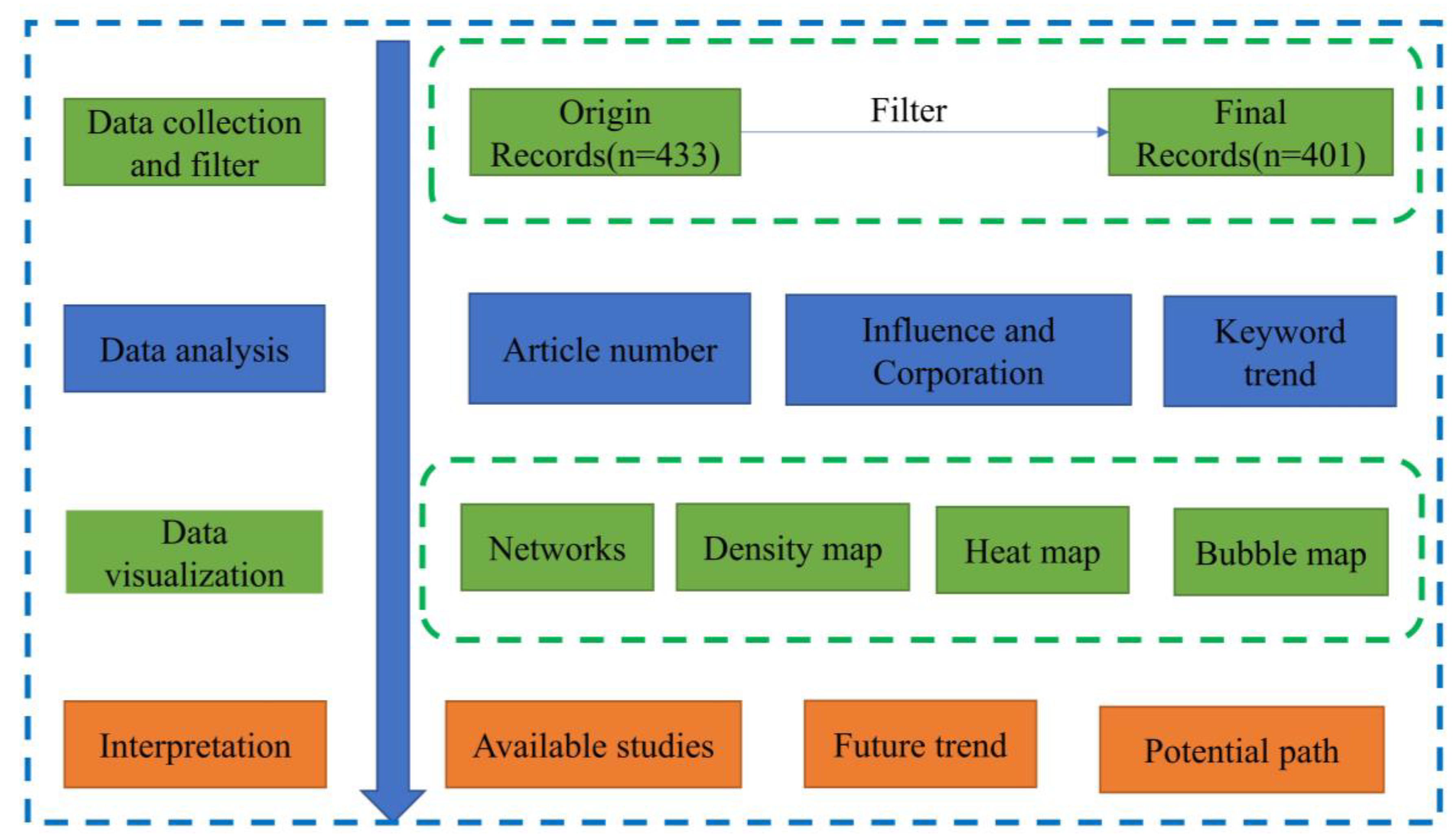
2. Materials and Methods

2.1. Data Collection and Search Strategy

The Web of Science (WOS) database is a premier academic research database that provides access to a vast collection of high-quality, peer-reviewed scholarly literature across various disciplines. WOS is widely regarded as one of the most authoritative and comprehensive sources for tracking and analyzing scholarly research output, as well as for identifying emerging trends and impactful research [52,53]. The database comprises multiple indexes, including the Science Citation Index Expanded (SCI-EXPANDED), Social Sciences Citation Index (SSCI) and the Arts and Humanities Citation Index (AHCI), covering over 22,000 high-impact journals and conference proceedings as well as books, reports and data sources. It is worth mentioning that the WOS database has strong correlation and crossover with existing popular databases, such as Google Scholar and Scopus [54,55]. In addition, the WOS database also contains the Chinese Science Citation Database (relevant Chinese literature will have corresponding English titles and abstracts), which is very useful for accessing scientific research in different language type. The quality of outcome produced by a bibliometric analysis heavily depends on the quality of the paper we choose [56,57,58]. The core database of the WOS is comprised of three main indexes: SCI-EXPANDED, SSCI and the AHCI.
In this paper, we selected the WOS core dataset and set the published period between 1990 and 2022. The WOS database provides an advanced search that allows you to filter the core database for articles on relevant topics by creating keywords as a search formulate. We set the WHs topic keywords as “World Heritage” and “World Property” and the topic keywords related to spatial technology as “Spatial technology”, “Remote Sensing”, “RS”, “GIS”, “Geographic Information System”, “GPS”, “Global Positioning System” and “Surveying and Mapping”. Using Boolean operators, the string formed the subject term search formula: A TS = (“World Heritage” OR “World Property”) AND (“Spatial technology” OR “Remote Sensing” OR “RS” OR “GIS” OR “Geographic Information System” OR “GPS” OR “Global Positioning System” OR “Surveying and Mapping”). The origin search record was 433 documents. Filtered by document type (review, article and conference paper) and language (English), 401 articles remained.

2.2. Bibliometric Analysis

Bibliometric analysis is a method of extracting key elements from the literature through a series of statistical methods and mathematical models, which quantitatively reflects the changes in relevant research trends [59,60]. Bibliometrics is a multidisciplinary field of study that employs quantitative methods to analyze and evaluate various aspects of the scholarly literature, including scientific publications, citations and academic journals [61,62]. It provides valuable insights into the patterns, trends and impact of research within specific academic disciplines. Bibliometric analysis has wide-ranging applications across academia and research, offering researchers and institutions the tools to assess the influence of publications, track research trends and make informed decisions.
In the realm of the literature and network analysis, several key terms play pivotal roles in understanding the connectivity and relationships between elements within a dataset or network. Links denote the connections or associations between different elements, serving as the threads that tie them together. Meanwhile, clusters represent cohesive groups of elements that share stronger connections with one another than with elements outside the group. These clusters often signify thematic or conceptual groupings within a larger dataset. Link strengths quantify the intensity or weight of these connections, providing insights into the significance of relationships. Higher link strengths indicate more influential or impactful connections. Finally, total link strength is a comprehensive metric that aggregates all the link strengths associated with a particular element, offering a holistic view of its prominence and interconnectedness within the network. These terms are indispensable tools for researchers and analysts, enabling them to navigate complex datasets, networks or bodies of articles and uncover valuable insights about their structures and interdependencies [60].
In this paper, the bibliometric analysis process involved following steps(in Figure 1): (1) Research topic design: clearly defining the focus of the research, which was the application of spatial technology in WHs and its future development trends. (2) Data collection and filter: Based on the research topic, a search strategy was developed using the WOS database and keywords for data collection, and the data source was then integrated and imported into the R platform. In bibliometric analyses, data usually come from different sources, formats and standards. Standardized data included uniform article titles, author names, journal names, etc. to ensure consistency. The dataset may contain duplicate bibliographic records that introduce bias in the analysis. The data cleansing phase involved identifying and removing these duplicate records to ensure that each study was counted only once. (3) Data transformation and analysis: The bibliometrix package was used to transform the data and extract information from the data source, including the time information of journal publications, collaboration between authors or institutions and extraction of paper keywords. Based on this, the analysis covered the publication volume of journals and countries, the contributions of authors and institutions in this field and the development trend of research. (4) Result visualization: The tidyverse package and VOSviewer software are drawn for t bar charts, network graphs, etc. (5) Interpretation of research results: After completing the above four steps, the results were combined with a summary and analysis of the relevant literature to discuss the application and development trends of spatial technology in the protection of WHs.
The bibliometrix package [63,64,65] on the R platform was utilized for transforming data and extracting key information while the ggplot2 package was employed to render statistical information visually. The VOSviewer software was used for visualizing co-citation networks of key terms and collaboration hotspots among international entities. The list of world heritage sites and the latitude and longitude coordinates is from UNESCO World Heritage Centre (https://whc.unesco.org/en/syndication, accessed on 19 September 2023). The use of the bibliometrix package, tidyverse package and VOSviewer in bibliometric research was of paramount importance. The “tidyverse” package offers essential tools for data preparation, statistical analysis and data visualization, making it instrumental in handling complex bibliometric datasets and creating informative visualizations. Meanwhile, VOSviewer specializes in constructing and visualizing collaboration networks, clustering research themes, and mapping keywords, enabling researchers to explore research dynamics and identify emerging trends. The integration of these tools streamlines the bibliometric analysis process, facilitating efficient data manipulation, insightful network analysis and comprehensive visualization, ultimately enhancing the depth and quality of bibliometric research [53,66,67].

3. Results

3.1. Analysis of Research Paper

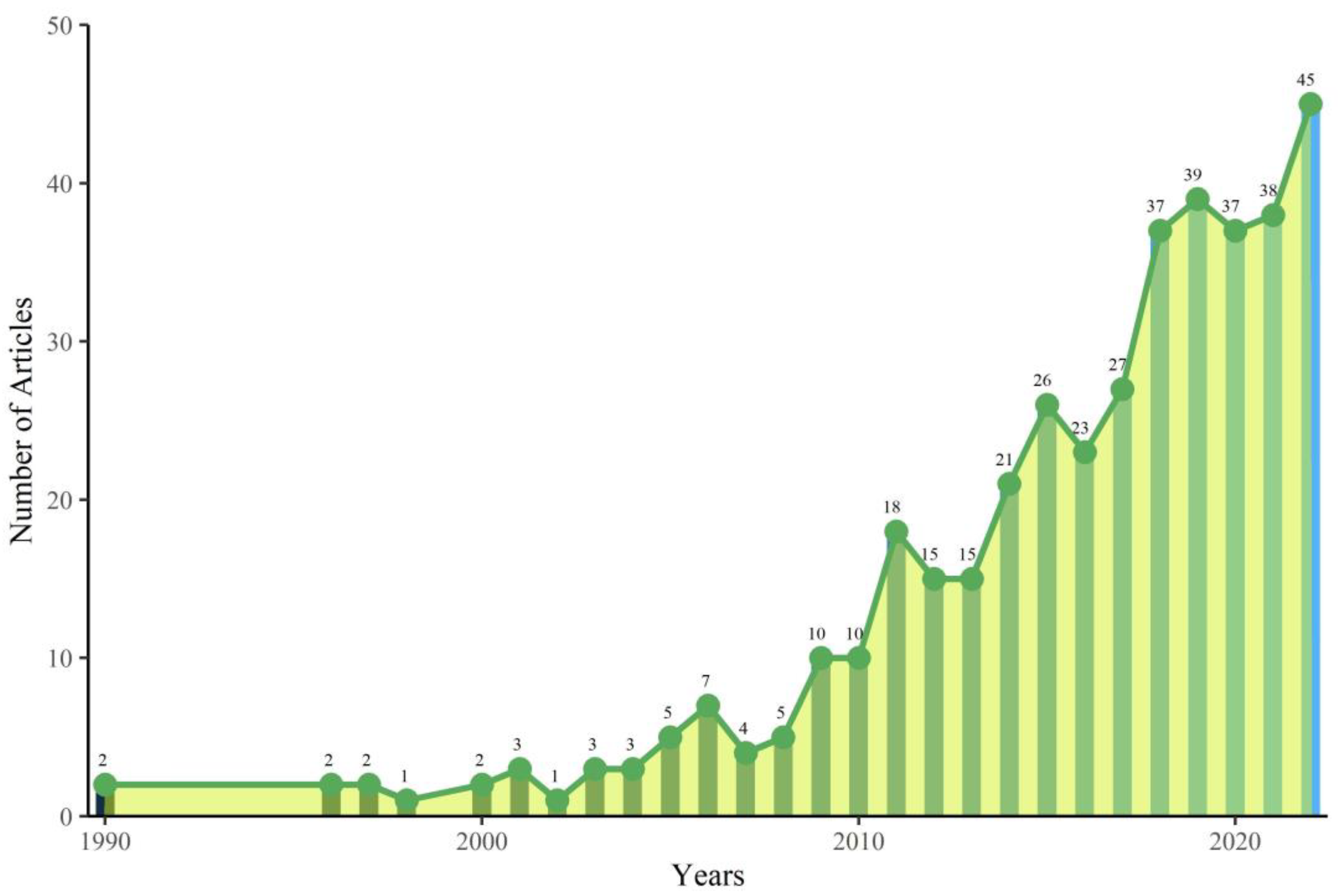
3.1.1. Analysis of the Published Articles

Figure 2 illustrates the scientific publications pertaining to permafrost research that have been published between 1990 and 2022. This comprehensive compilation is invaluable in discerning the fundamental and overarching characteristics of this field. In 1970, two related articles were published: Refs. [68,69]. At that time, Landsat satellite data was utilized to map land cover types in the Willandra Lakes World Heritage Region. Since 2007, the application of space technology in WHs has gradually increased, and the number of articles in the remote sensing has reached its peak during this period [70]. From 2007 to 2022, the number of published papers per year has rapidly increased, with 45 relevant articles published in 2022, representing an annual growth rate of 10.22%. Alviz-Meza [71] collected the application of science and technology on sites during the period 2016–2022, and the average annual growth rate of its study is calculated to be 51.93%. It can be seen that space technology contributes to archaeological sites to a high degree, accounting for almost 20% of all technologies. Table 1 presents the details of the data sources, and a total of 1471 keywords were extracted from 401 papers published by 1515 authors from 1990 to 2022. It should be noted that relevant articles, conference papers and reviews are also considered in this study.

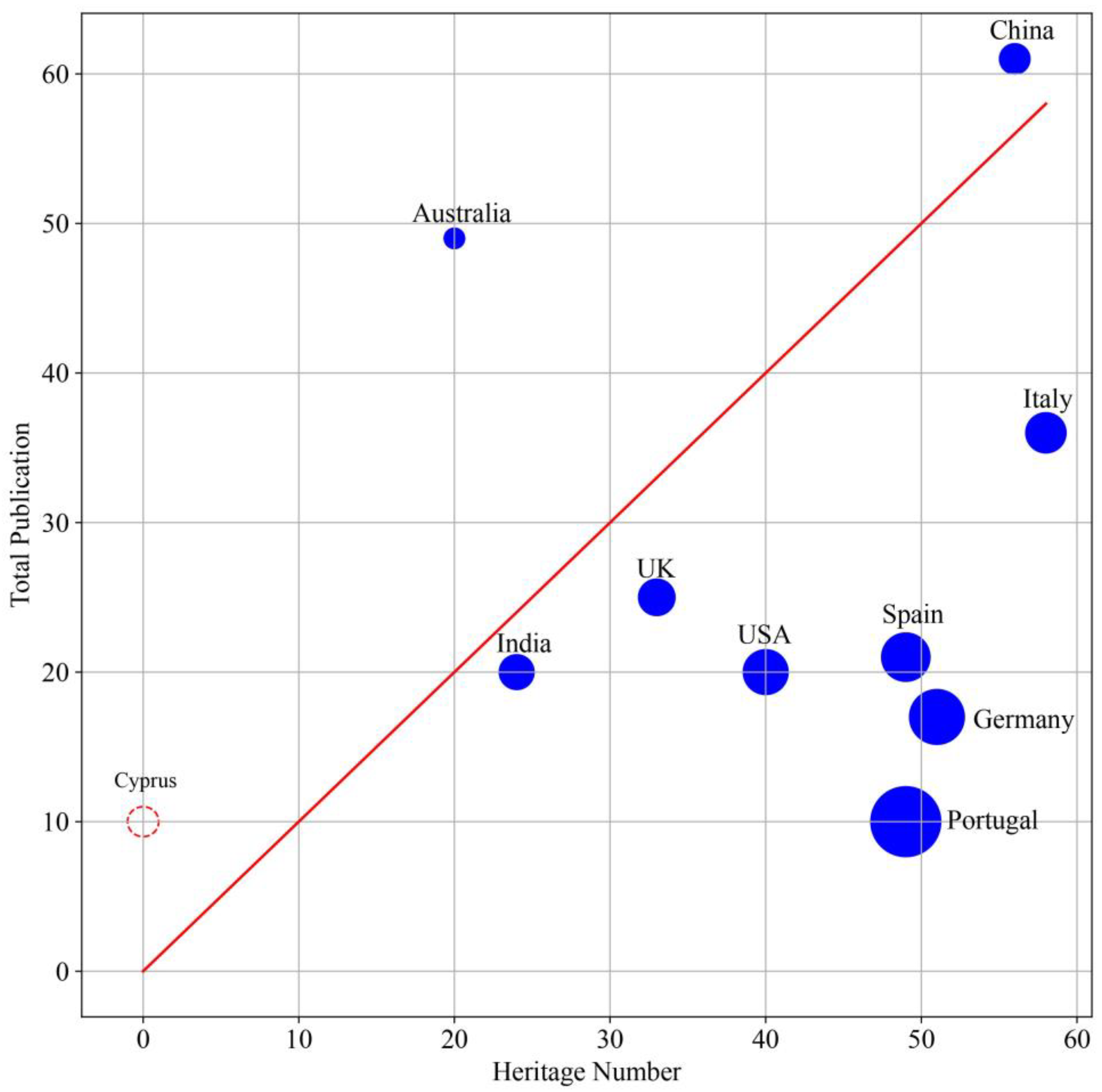
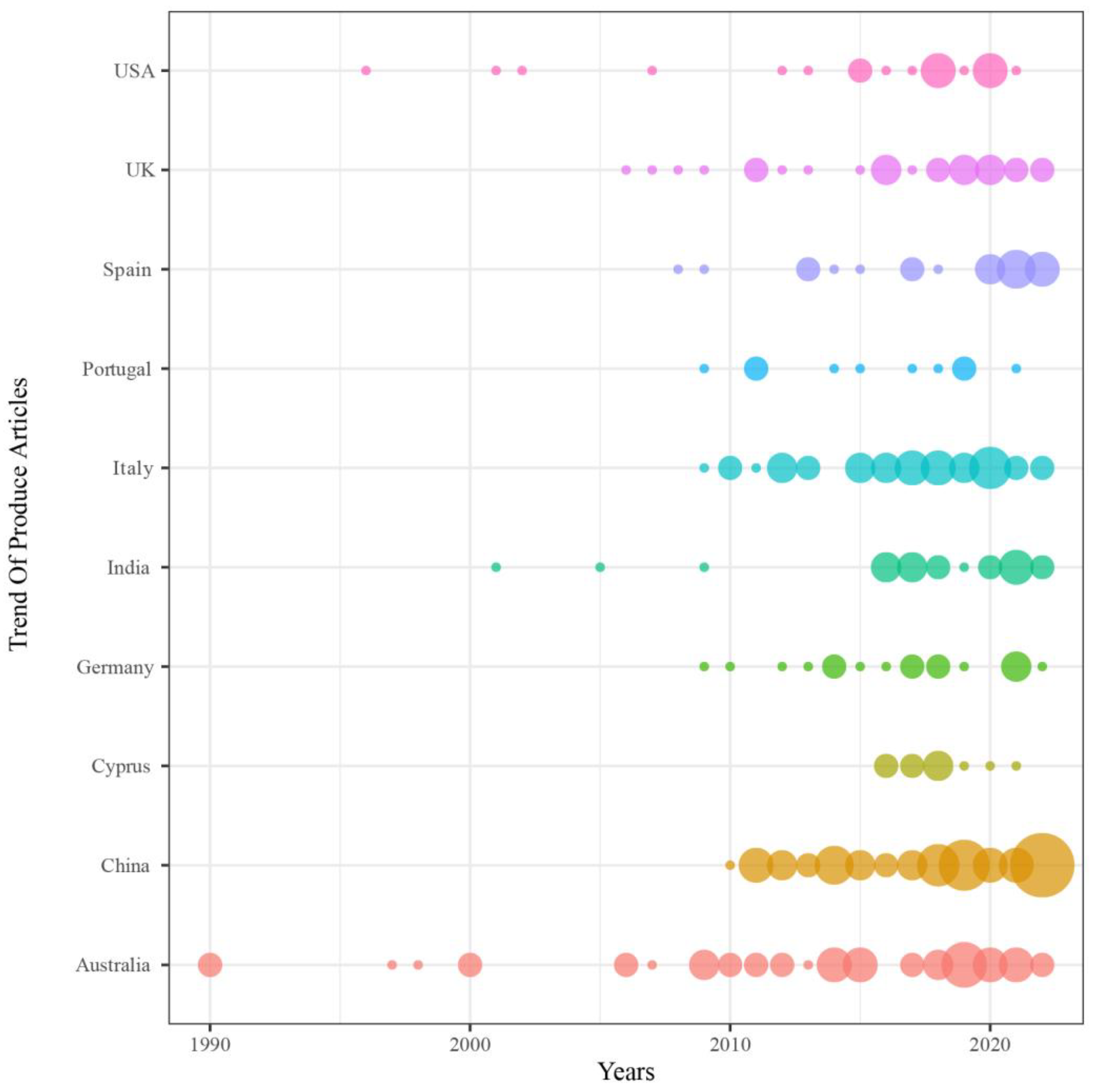
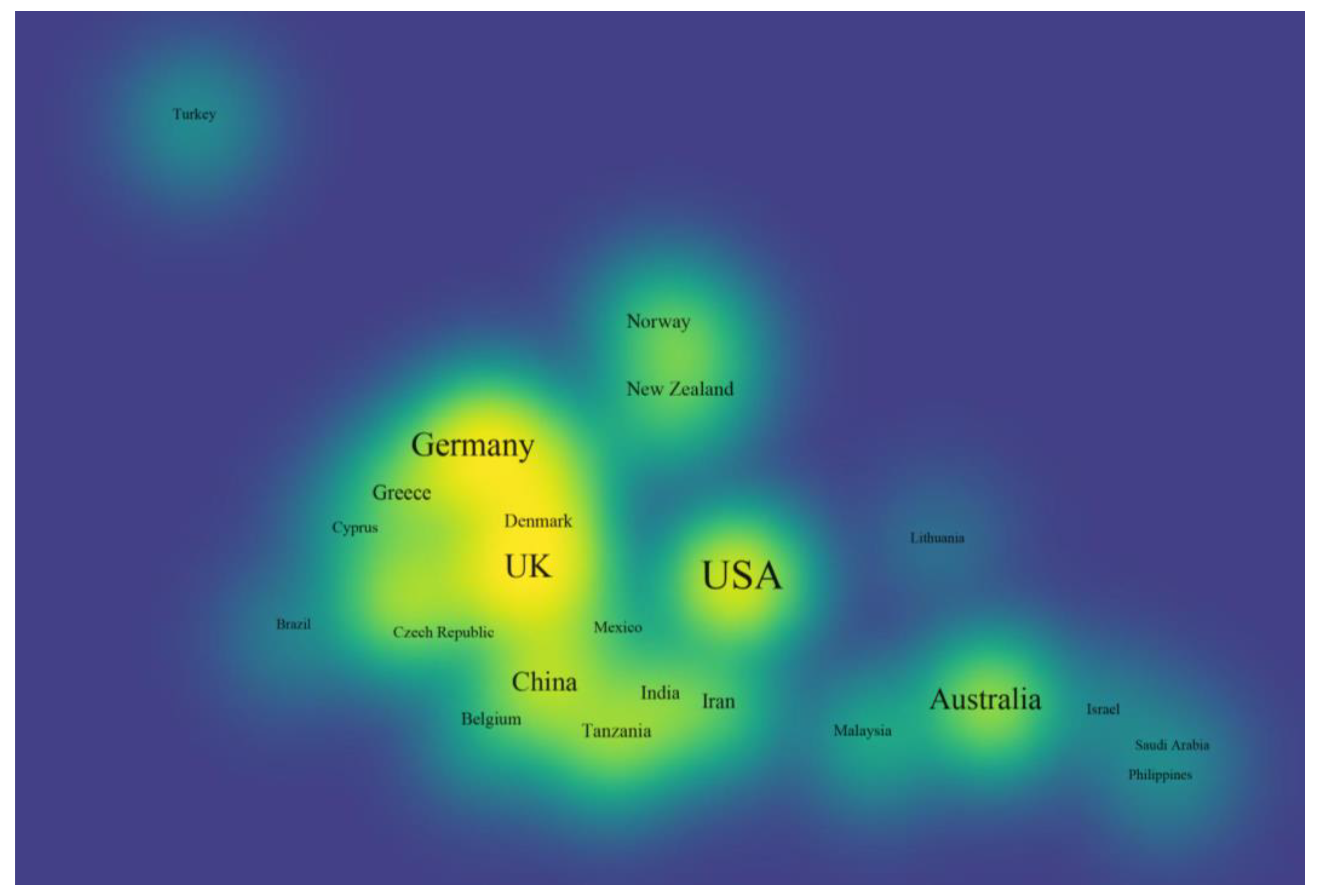
3.1.2. Relationship between Publications and Heritage Sites between Countries

Figure 3 extracts the total number of articles from the top 10 countries in terms of the number of articles issued, showing the comparison between the number of world heritage sites and the total number of articles issued at the national level. The red bar indicates the number of world heritage sites, and the other bar indicates the level of article issuance by country. In terms of the number of publications, China > Australia > Italy > UK > India > other countries. In terms of the number of world heritage sites, Italy > China > Germany > Spain > Portugal > other countries. It may be seen that the coverage of heritage sites by space technology is far from adequate, and there is a great imbalance in the application cases of space technology in heritage sites in different regions. Among the top 10 countries in terms of number of publications, 70% of them are well below the ratio of 1:1. This implies that there is still a great potential for space technology in heritage sites, which implies a lack of attention to related research and applications. A more interesting point is that Portugal, a place without heritage sites, still has a certain amount of publications. China, as the country with the largest number of publications, mostly monitors and evaluates the ecological environment and natural risks of the world heritage sites with remote sensing [26,72], focusing on the ecological environment around the Great Wall [73] and the famous world heritage sites, such as the Huangshan Mountain [74]. Australia, on the other hand, has a long-term monitoring of the ecological environment of the great barrier ref. [75]. Italian researchers are mainly centered on monitoring natural disasters in world heritage sites [76], such as landslides and other geological disasters [77].
Figure 4 depicts the chronological order of the top 10 countries in terms of the number of articles issued, with the size of each bubble indicating the corresponding number of publications. According to the order of publication time, Australia was the first country to utilize space technology in WHs, with a steady increase in the number of publications over the years, particularly after 2010. In the United States, the first use of space technology in WHs was in 1996, but there was weak continuity in publications overall. India started publishing in 2001, but no relevant articles were issued from 2000–2015. As the leading publisher, China published its first visible paper on space technology application to WHs in 2010 and has maintained a high number of annual publications since then. Furthermore, a more notable pattern is observed whereby the number of publications has significantly increased since 2015 [77], both overall and at the individual country level.

3.2. Analysis of Influence and Collaboration

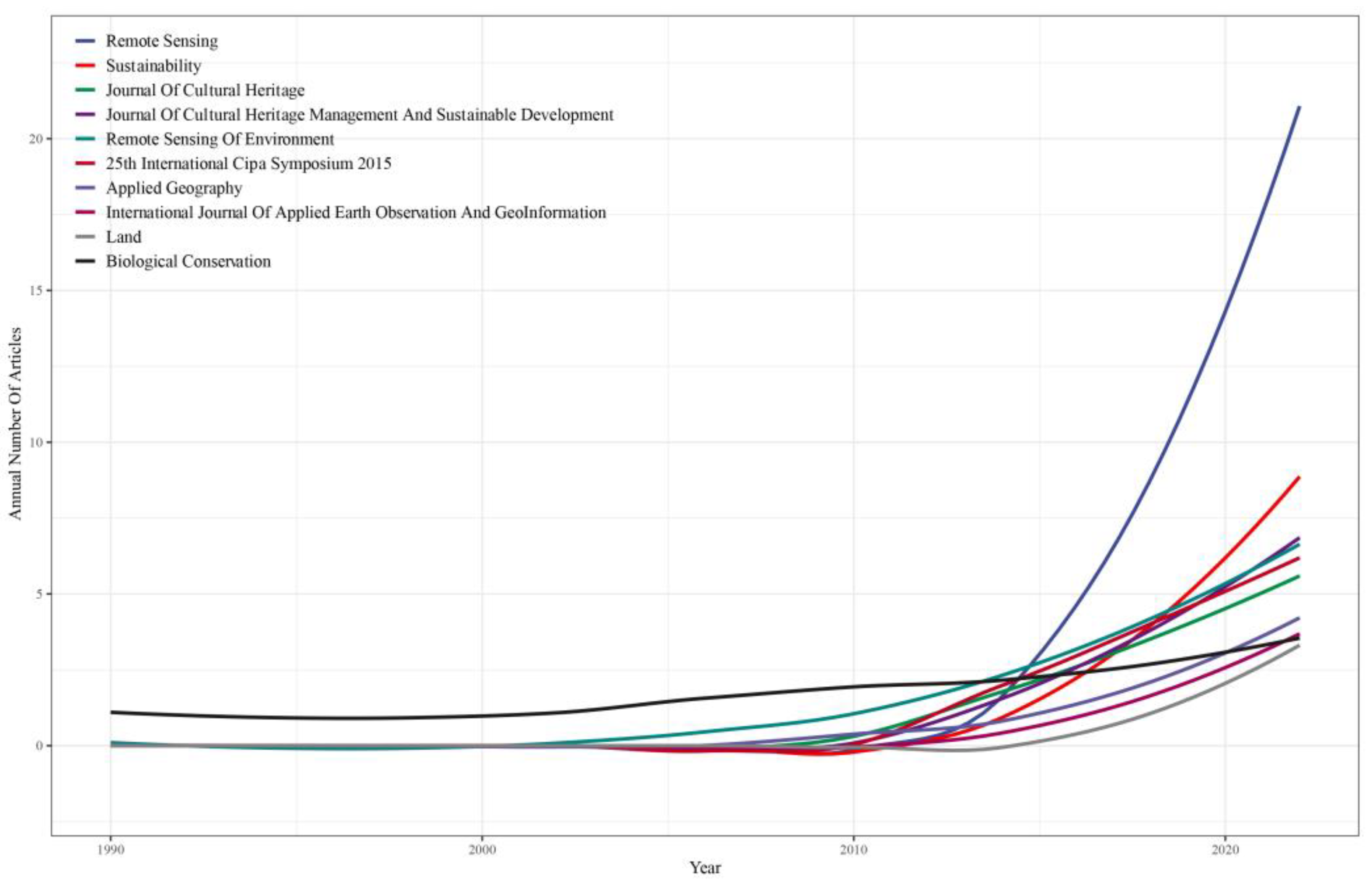
3.2.1. Analysis of Source Influence

Source represents a collection of articles on spatial technologies for WHs. Analyzing the dynamics of relevant research postings in source and identifying the core source can better focus on the spatial frontier technologies and new perceptions of WHs. A total of 401 articles on the application of spatial technology to WHs have been published in 256 sources, ranging from 2 sources in 1990 to 38 sources in 2022. We ranked the cumulative number of publications per year for each source and identified the top 10 sources, as shown in Figure 5. The top 10 sources, in order of ranking, are: Remote Sensing, Sustainability, Journal of Cultural Heritage, Journal of Cultural Heritage Management and Sustainable Development, Remote Sensing of Environment and so on. In 1990, the journal Biological Conservation published an article on the mapping of natural vegetation for heritage site management in Tasmania, Australia [68]. After 2010, the number of publications in each source began to increase rapidly. The most notable increase was seen in the journal “Remote Sensing”, which showed a higher growth rate and trend than the other top 10 journals.
According to Table 2, the top ten most influential journals were selected based on the number of local citations. The journals marked with an asterisk (*) are considered core sources in accordance with Bradford’s Law. It can be seen that the total number of citations and publications of the Remote Sensing are the highest, with 318 and 21, respectively. Marine Pollution Bulletin and Remote Sensing of Environment rank second and third in total citations, with 267 and 196, respectively, while their number of publications are 4 and 6, respectively.

3.2.2. Analysis of Institution Influence

Research institutions play a primary role in driving the protection of WHs through spatial technology. The greater the influence of these institutions, the more likely they are to foster excellent researchers and make outstanding contributions in the relevant field. The full article record exported from the WOS database enables access to the institution’s dynamics of publishing articles. The results demonstrate 622 institutions actively engaged in research on the application of space technology to water hazards. Table 3 and Table 4 display the total number of citations and publications based on each institution’s impact assessment publications, as well as the top 10 institutions ranked by country of origin. The Chinese Academy of Sciences ranks first with 1727 total citations, followed by James Cook University (615), Charles Darwin University (393) and University of Queensland (384), which are the top 2–4 citation leaders in Australia. The total number of citations declines in stages from third place onwards. In terms of publications, the Chinese Academy of Sciences has 110 total publications, followed by the University of Queensland (36), Cyprus University of Technology (27) and Charles Darwin University (27) in Australia. There is a substantial difference between institutions regarding total citations and publications, particularly between the top and bottom five. The Chinese Academy of Sciences maintains its position as the leading institution, and the University of Queensland in Australia remains among the top four.

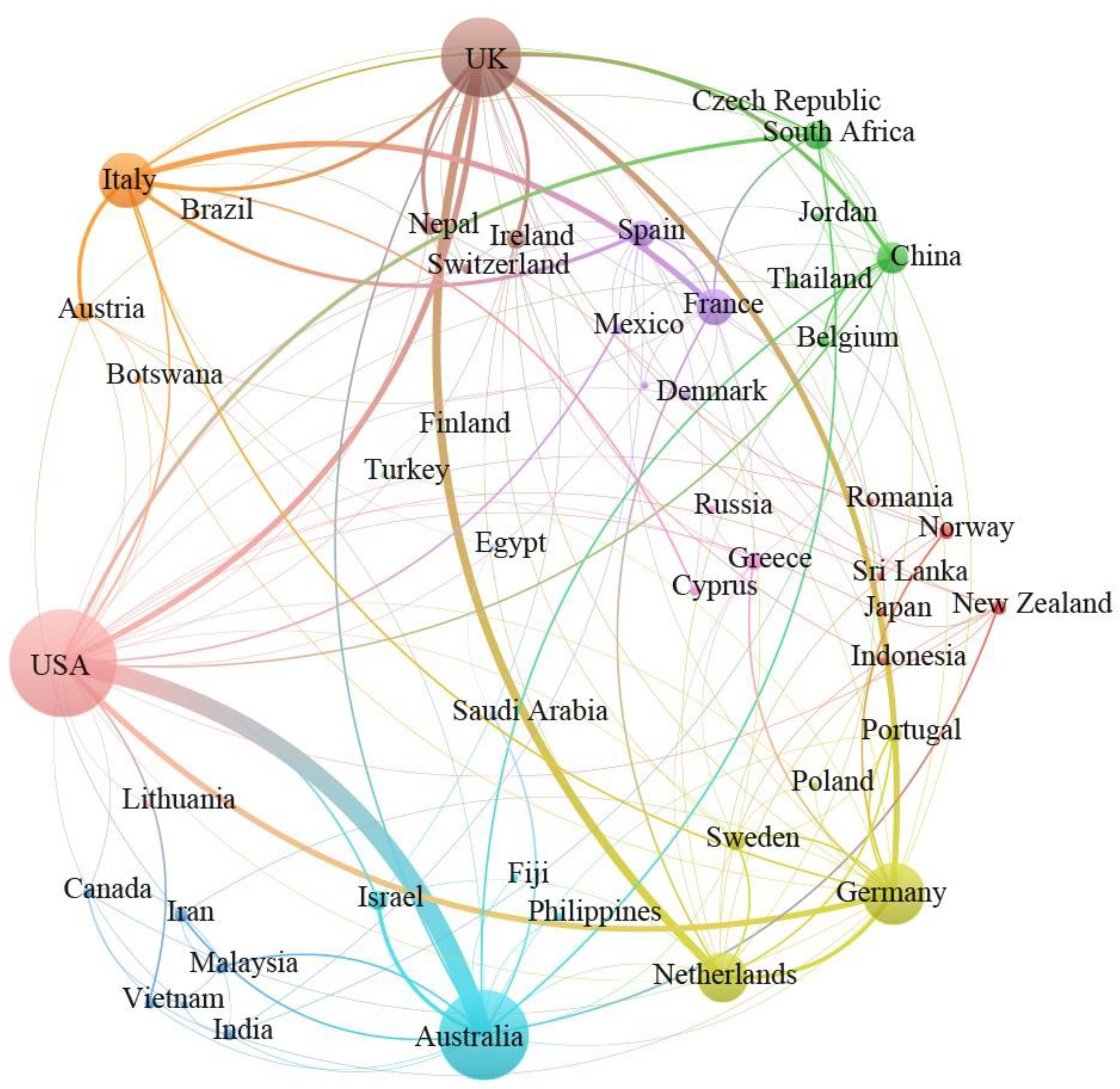
3.2.3. Analysis of Collaborative Relationship

National cooperation is an important part of the conservation and development of WHs and is the backbone of achieving SDG 11.4. Figure 6 and Figure 7 show the network and heat map of cooperation between countries. The lines between Figure 6 indicate cooperation between countries, and the thickness of the lines indicates the strength of the cooperation. Figure 7 is a heat map of the density of national cooperation agencies. The more the countries cooperate, the brighter the yellow colour of that country’s representation. The most extensive cooperation is found in the United Kingdom (UK) and Germany. The UK has the most cooperation with Netherland and Germany, and Germany has the most cooperation with the UK and the United States of America (USA). It is the USA, China and Australia that have more extensive cooperation. It is the USA that has the most cooperation with the UK and Australia, China with the UK and the USA and Australia with the UK and China.
Although there are exchanges of cooperation between countries, the intensity and breadth of their cooperation is still not extensive enough (in Figure 6 and Figure 7). In the context of Figure 3, Italy, the country with the largest number of heritage sites (58 WHs), has a relatively low level of intensity and breadth of cooperation. China, which has the second largest number of heritage sites (56 WHs), relies mostly on self-reliance with domestic institutions. In general, there is not enough technical cooperation and research exchange between countries, and the space technology powerhouses (e.g., the USA, China, Russia, India, etc.) still do not pay enough attention to WHs, and collaborative work on heritage conservation and development between each other still needs to be developed. There are still not enough cases of spatial technology research in the big world heritage countries (Italy, China, Spain, USA, etc.), the coverage of WHs is still not wide enough and the spatial information characteristics of heritage sites have not been fully explored yet. In the context of SDG11.4, international exchanges should be actively maintained between countries to make full use of professional institutions and space technologies to provide more and better implementation paths and methods for the monitoring, conservation, management and development of world heritage sites. They jointly promote the development of national heritage conservation awareness and the improvement of conservation levels.

3.3. Evolution and Trend of Research Topic

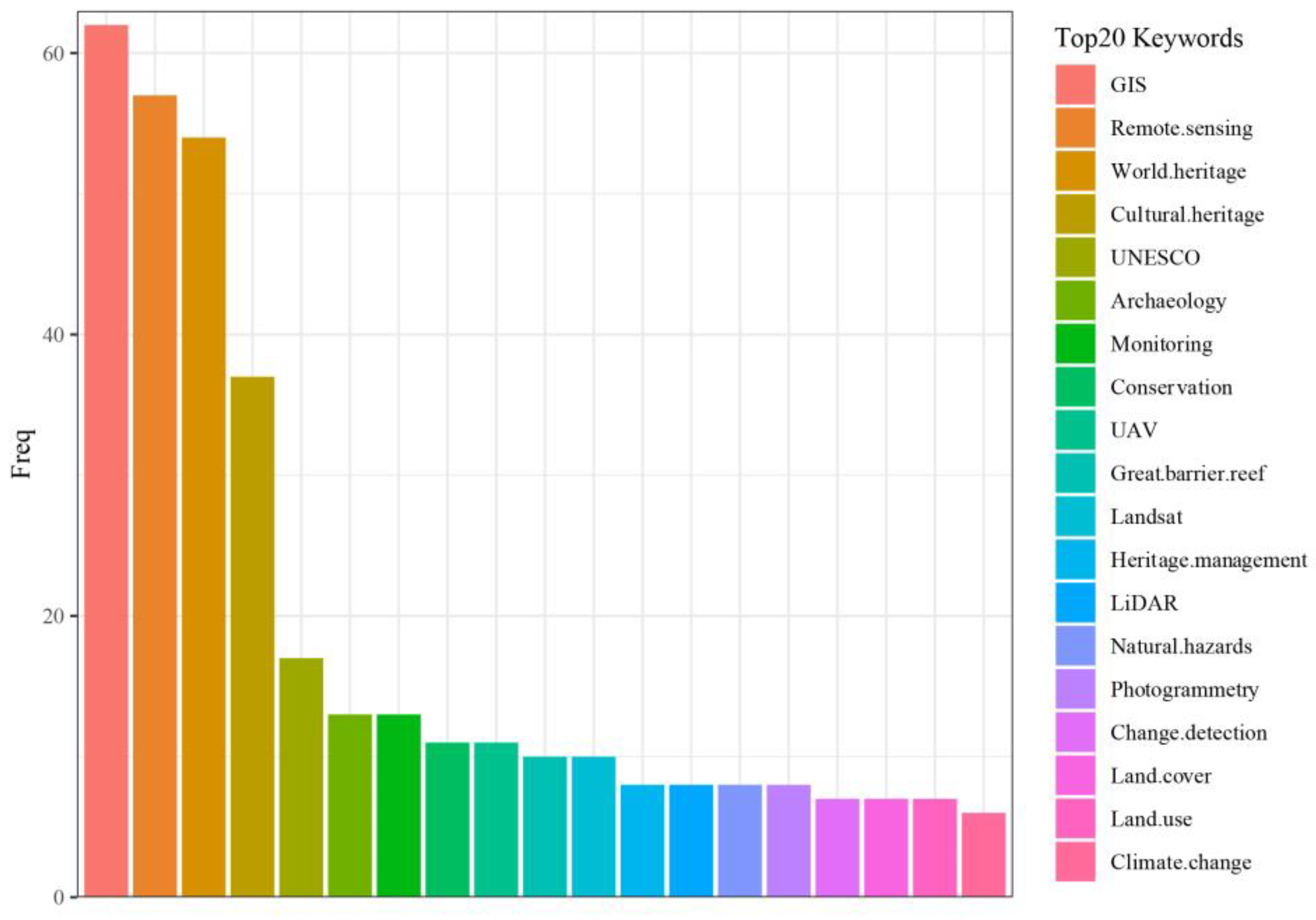
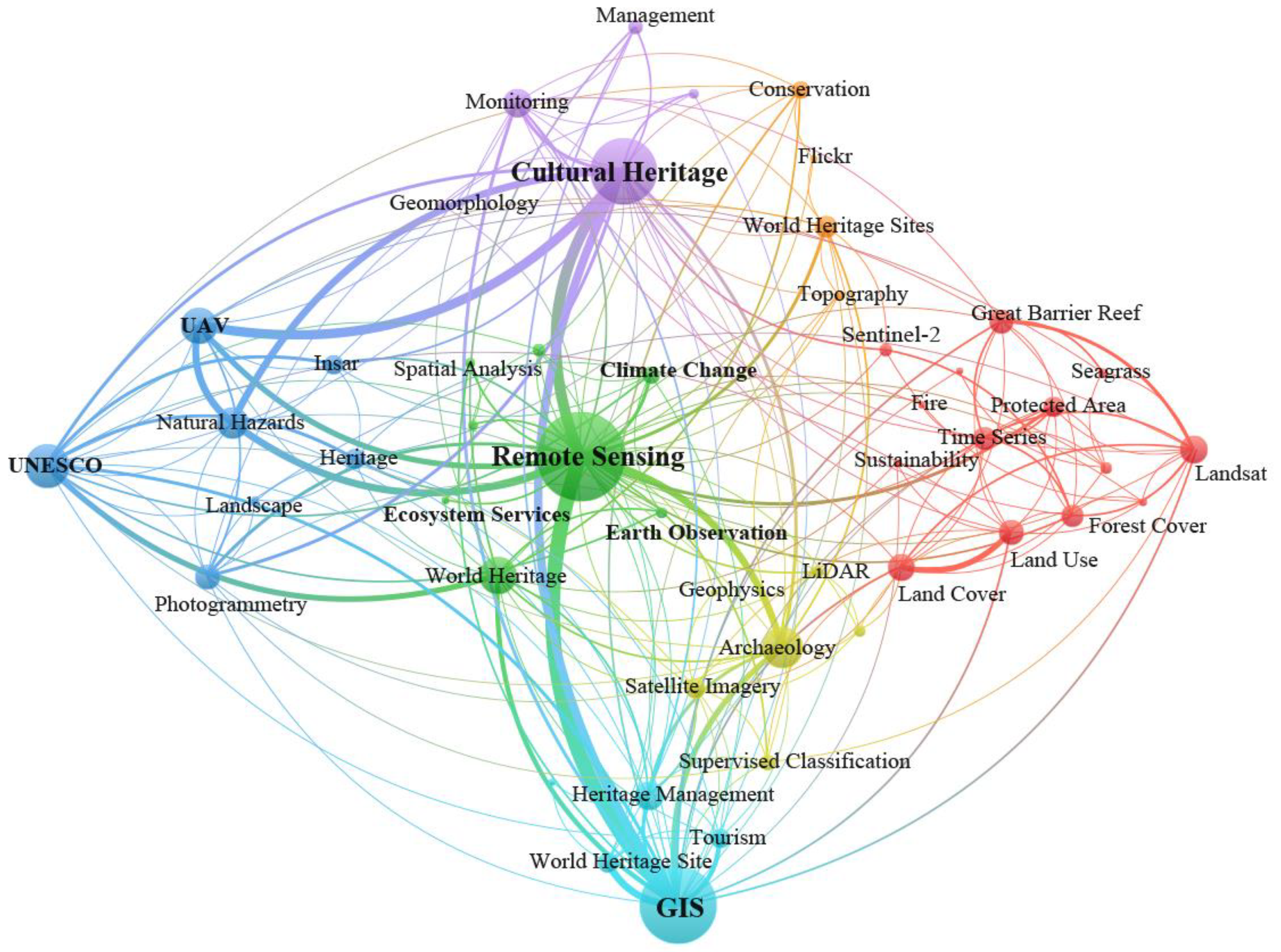
3.3.1. Keyword Frequency Statistics and Co-Occurrence Networks

Keywords are the author’s condensed and concise version of the whole article, which is a reproduction of the research object, research techniques and other aspects of the author’s research work [78,79,80]. Extracting keyword information from 401 relevant studies can provide accurate textual information to grasp the common techniques, hot methods and future trends of existing research. Figure 8 shows the keyword frequency information from the published literature. GIS and Remote Sensing are the first and second most popular. The trend of applying GIS and remote sensing technologies to WHs is obvious [81]. RS provides a rich source of spatial information for WHs, and the reflective properties of features in multiple wavelengths, such as visible, near-infrared and laser, provide a fine portrayal of the different spatial hierarchy, soils, topography, etc. [82,83,84]. In particular, the advent of UAV technology, which is better adapted to complex terrain, has great advantages in areas such as hills and mountains of small to medium size. In addition, UAV platforms can be paired with high spatial resolution cameras and multispectral sensors to facilitate high-resolution mapping for WHs in real time and with high efficiency [85,86,87,88]. GIS can integrate multiple data sources, such as remote sensing images and practical expeditions to build accurate digital world heritage datasets for long-term monitoring and real-time updates of heritage sites [81,89,90,91,92,93]. In addition, GIS can be used for the planning and design of world heritage sites and natural resource conservation and is an important tool for the sustainable development of heritage sites.
A co-occurrence network of keywords is a visualization that shows the relationships between different keywords based on how often they appear together in a given corpus of text [94,95,96]. The network is created by first extracting the keywords from the text using natural language processing techniques, and then creating a co-occurrence matrix that represents the frequency of each pair of keywords appearing together. This matrix is then used to create a network graph that shows the relationships between the keywords, with nodes representing individual keywords and edges representing co-occurrence between pairs of keywords. The graph can be customized to highlight important nodes and adjust the layout, and labels can be added to make the visualization more informative [97,98]. The resulting visualization can help users identify patterns and relationships between different keywords and can be useful for awareness of current progress in the WHs conservation and sustainability field of spatial paradigm research. The co-occurrence network of WHs and spatial technology keywords was constructed and visualized based on the top 50 most frequent keywords of 401 articles(in Figure 9). The three keywords “Remote sensing”, “GIS” and “Culture Heritage” were the key nodes, and the co-occurrence between them was the linkage between the three keywords “Remote sensing”, “GIS” and “Culture Heritage” is also strong. This also indicates that remote sensing and GIS are widely used spatial tools for studying world heritage. Apart from the interconnection between the key nodes, the “Remote Sensing” node is mainly interlinked with the “UAV” node and the “Archaeology” node. The nodes are interlinked with each other. In recent years, UAV has been widely used as a member of remote sensing technology for heritage exploration, conservation, documentation and survey monitoring [99,100,101,102,103]. “The ‘GIS’ nodes are mainly linked to the ‘Tourism’ node and the ‘World Heritage’ node. Lelong [104] and others have used the GIS aggregated spatial analysis module to assess the spatial conversion of core heritage sites and the spatial pattern of tourism under rapid tourism development. The main nodes linked to ‘Culture Heritage’ are the ‘UAV’ and ‘Monitoring’ nodes, which suggest a preference for the use of UAVs to observe the spatial information of cultural heritage with high accuracy and to monitor the physical changes of cultural heritage [36].
The keywords with a frequency above 30% involve terms or types of spatial information technology that are more recognized and acknowledged in the academic field and have more mature technical applications. 20% or less of the keywords represent new areas of academic interest or applications of new technology that will be a research hotspot in the field in the coming period, especially changes in heritage land cover, climate change impacts on heritage sites, dynamic monitoring of heritage sites and AI-related neural network technologies, among others. Technological advances and the issues facing heritage sustainability are seen in these keyword trends.
The cooperation areas, mainly remote sensing, cultural heritage and GIS, reflect the co-construction and sharing of spatial information technology in heritage conservation in the era of big data. Although big data was not used as a theme word in the search for this paper, the cooperation network relationship from the keywords fully reflects the concept of co-construction and sharing of spatial big data for heritage conservation.

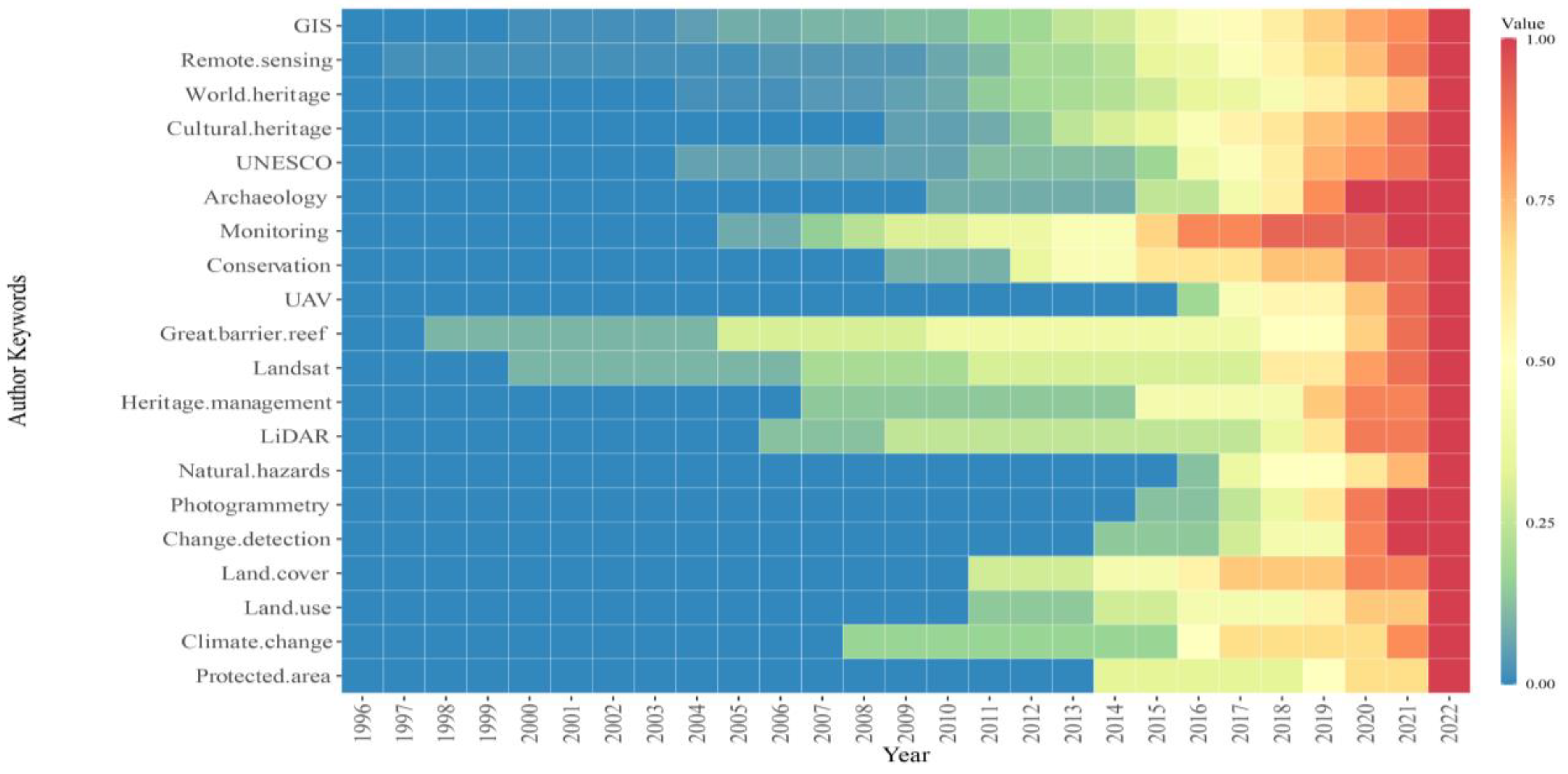
3.3.2. Temporal Change and Maturation of Keywords

The thematic evolution is mainly represented based on the change of color in Figure 10. The change of color in Figure 10 represents the change of word frequency of keywords. We extracted the keywords, performed word frequency statistics and normalized the word frequencies in chronological order. The change of color from blue to red indicates that the word frequency of the keyword is gradually increasing, which means that the technology or field represented by the keyword is gradually integrated into the application of the world heritage site and also means that the application of the technology in the world heritage site is extensive and mature. The evolution of keywords in remote sensing and world heritage fields reflects the changing priorities and technologies within these fields. As research continues to evolve, keywords will continue to reflect the latest developments and challenges in the field. In the early days of remote sensing and world heritage research, keywords were often focused on specific technologies or objects. Most of the early articles focus on the keywords ‘GIS’, ‘Remote Sensing’ and ‘World Heritage’. It can also be seen that the Great Barrier Reef is the early classic research object for spatial technology in world heritage [105]. Although Landsat satellite imagery was used to study the fire history of Kakadu National Park in 1997 [106], the direction of research on Landsat was not seen again until 2000, when the assessment of fire conditions in Kakadu National Park was continued [104]. It was only in 2000 that the assessment of fire conditions in Kakadu National Park was continued [107].
Over time, the use of remote sensing and world heritage research has become more multidisciplinary, incorporating a range of disciplines such as geography, anthropology and architecture. In 2004, Mario presented the United Nations Educational, Scientific and Cultural Organization (UNSECO) study on the use of satellite imagery for monitoring world heritage sites and highlighted the use of remote sensing. This has led to the emergence of the keywords ‘UNSECO’ and ‘monitoring’. The development of advanced remote sensing techniques, such as hyperspectral imaging and LiDAR [23,108,109,110], has led to the creation of new keywords related to these technologies. The rise of digital heritage has led to the development of new keywords related to “Heritage management” [111,112,113]. As conservation [37,114,115] and management have become increasingly important aspects of world heritage research, keywords have shifted to reflect this focus. WHs are often highly sensitive to environmental changes and require careful management to ensure their preservation. Land use change, such as deforestation, agricultural expansion, urbanization and mining, can directly or indirectly affect world heritage sites through impacts on their ecosystems, biodiversity, water resources and cultural values [116,117,118,119].
With the growing awareness of the impact of climate change on cultural heritage sites, new keywords have emerged related to climate change and world heritage. Climate change poses a significant threat to WHs. Climate change can affect these sites in several ways, including sea level rise [120], air pollution [29,121], increased frequency and intensity of extreme weather events [122,123,124] and changes in weather patterns [111,125,126].

4. Discussion

Spatial technologies play an important role in the conservation and development of world heritage sites. A bibliometric analysis of spatial technologies for world heritage sites can provide insights into the current status and trends of research in this field. The results of the keyword analysis (Figure 8, Figure 9 and Figure 10 show that remote sensing and GIS are important spatial technology tools for the conservation of heritage sites. We consider the Great Barrier Reef as a classic example of space technology contributing to the development of world heritage sites, which has received continuous attention and research from 1998–2022 [75,105,127,128,129,130,131,132,133,134,135]. The study of the Great Barrier Reef is a valuable experience in observing the space of marine type world heritage sites. In the development of space technology, Landsat satellite imagery has been the most widely used; from the later emergence of Sentinel-2 satellite data applications to the use of LiDAR data, the spatial observation of world heritage sites has become increasingly refined and comprehensive. In terms of research focus, people have evolved from simply monitoring heritage at the beginning to heritage management and conservation to land cover change and climate change risk prediction in heritage sites, and the research aspects of world heritage sites have become increasingly diverse, cutting-edge and comprehensive. However, a number of research problems have been revealed: (1) Insufficient attention in the top 10 countries in terms of number of articles published; for example, 70% of these countries failed to reach the number of articles:world heritage sites = 1:1 (Figure 3). This implies that spatial studies related to world heritage sites have not yet been covered comprehensively and that national attention and focus on world heritage sites is insufficient. (2) Insufficient international cooperation and exchange: Research on world heritage sites is mostly confined to domestic institutions, and international cooperation and exchange is less and not sufficient (Figure 7 and Figure 8). Enhancing the sharing of results among international organizations can better promote the early achievement of SDG11.4 goals.
Climate change introduces a range of threats to heritage sites worldwide. These include rising temperatures, increased precipitation, sea-level rise, extreme weather events and shifting ecosystems [136]. Such changes can result in physical damage to historic structures, accelerated deterioration of materials and the loss of biodiversity in and around heritage sites. Remote sensing technologies offer the capability of monitoring climate parameters, such as temperature, humidity and sea-level rise, with precision [33,137]. These data enable heritage site managers to anticipate and respond to climate-related threats promptly. GIS allows for the creation of detailed risk assessment models, identifying vulnerable areas within heritage sites and evaluating potential climate change impacts [138,139]. This information guides adaptation and mitigation strategies. Spatial technologies provide valuable data for evidence-based conservation practices. They enable the monitoring of structural changes, the tracking of environmental conditions and the assessment of ecosystem health, allowing for proactive conservation measures [140,141].
While the multi-remote sensing technology, coupling between multiple disciplines and the integration of big data, cloud computing, and artificial intelligence as important frontiers for spatial technology development in WHs, it is equally important to recognize that the adoption of these cutting-edge technologies is not without its challenges and potential risks. Addressing these challenges will provide readers with a more comprehensive understanding of the complexities and considerations involved in the integration of spatial technology for heritage conservation in WHs. We must note the following risks and challenges: (1) Data Privacy and Security: One of the foremost concerns revolves around the safeguarding of sensitive data. The integration of big data and cloud computing entails the storage and transmission of vast amounts of information related to WHs. With this comes the risk of data breaches, cyberattacks and unauthorized access. Therefore, robust data privacy and security measures must be implemented to protect the integrity and confidentiality of heritage data. (2) Cost and Resource Constraints: Despite the promise of these technologies, their adoption can be financially burdensome. Many WHs, particularly those in less economically developed regions, contend with limited budgets and inadequate infrastructure. The challenge lies in finding a balance between the advantages offered by cutting-edge technologies and the resources available for their implementation. (3) Data Accuracy and Quality: Additionally, while these technologies excel in data collection and analysis, ensuring the accuracy and reliability of the collected data remains a critical concern. Inaccurate or low-quality data can lead to erroneous decisions and actions that could potentially harm WHs. Therefore, rigorous validation and verification processes must be in place to guarantee the accuracy of the information used in decision-making processes. (4) Integration Complexity: Integrating multiple technologies and disciplines can be technically complex. Ensuring seamless interoperability among various systems and datasets is a challenge that must be addressed to harness the full potential of these innovations. By addressing these multifaceted challenges encompassing data privacy and security, cost and resource constraints and data accuracy and quality, we can pave the way for the responsible and effective integration of spatial technology in heritage conservation at WHs. Each challenge underscores the importance of a comprehensive and strategic approach to technology adoption in this unique context.
Financial constraints, infrastructure gaps, cultural sensitivity, bureaucratic hurdles and limited data access collectively pose formidable challenges to the widespread adoption of spatial technology for heritage conservation. Many nations, especially those with limited resources, struggle to allocate funding for advanced technology acquisition due to the high costs involved in hardware, software and skilled personnel. Insufficient or outdated technology infrastructure, such as poor internet connectivity and data storage facilities, further hampers integration. The delicate balance between technology adoption and cultural preservation requires careful consideration, as local communities and stakeholders may resist the introduction of technology. Complex bureaucratic processes and regulations can hinder swift integration, necessitating streamlined administrative procedures. Lastly, limited access to high-quality spatial data and satellite imagery presents an additional obstacle, requiring efforts to negotiate data-sharing agreements and invest in data acquisition. Addressing these challenges is crucial to promoting equitable and effective spatial technology use in heritage conservation.
In the course of research and analysis, there are many details in this study that deserve to be refined: (1) the WOS database is currently the most widely used scientific citation database, but there are still quality articles that are not included in the database. In addition, we collected studies in English, and exclusions were made for other languages. (2) The subscripts were not accurate enough when extracting information. Subsequent related research should focus on this problem, and advanced word separation algorithms are needed to extract the complete semantic information as much as possible. (3) It is worth noting that the WOS database is by far the main literature collection. However, it is important to note that the choice of different databases and languages often leads to biased results. It is crucial to consider various strategies for a more robust bibliometric analysis. These include the use of multiple comprehensive databases, multilingual search approaches to mitigate language bias and correction methods to address potential biases. It is also important to transparently acknowledge the limitations inherent in a bibliometric analysis within the study and advocate for a multimethod approach when possible. By implementing these measures, researchers can enhance the reliability and credibility of their findings in the realm of spatial technologies’ impact on WHs’ conservation and development.

5. Conclusions

Spatial technologies are now widely used in the conservation and planning of world heritage sites in various countries. A bibliometric analysis of spatial technologies for world heritage sites provides valuable insights into the current state of research in the field as well as potential future trends. The discussion of the analysis highlights several important themes and research gaps that can inform future research and development in the field. Using bibliometric analysis, this paper systematically accessed 401 documents in the WOS core database for the field of spatial technology applications in WHs from 1990–2022, from which information such as authors, journals and keywords were extracted. The study quantitatively analyses the influence of authors, sources and institutions and shows the collaborative research relationships between countries. Finally, keyword frequency statistics, co-occurrence networks and development heat maps were used to reveal trends in spatial technology in WHs.
Based on the results of the literature analysed above, future trends and potential pathways for space technology in the conservation and sustainable development of world heritage sites were explored. By analysing the current status of development, cooperation and exchanges, as well as technological perspectives, we summarize the “4D” characteristics of space technology in world heritage sites:
(1)
Develop: Spatial applications in world heritage sites have gradually developed with an annual growth rate of 10.22% during the period 1990–2022. However, the application of space technology in heritage sites started late, and 70% of the top 10 countries in terms of the number of articles published failed to achieve document: world heritage site = 1:1. This indicates that there is still great potential for the development of space technology in heritage sites.
(2)
Discrepancy: The top 10 most influential journals and countries found that there was not much difference in influence between authors, but the difference in the number of publications and influence between journals and institutions was obvious and fluctuated greatly.
(3)
Desirable: The collaboration between countries is not very close and is more of a domestic institution. The shared exchange between international needs to be strengthened.
(4)
Diversity: Remote sensing technology and GIS are the most representative spatial technology tools in the conservation and development of world heritage sites. From single science to multidisciplinary integration, from Landsat satellite data to the application of UAV LiDAR data. The coupling of multiple remote sensing technologies, big data, cloud computing and the embedding of artificial intelligence will be the future trend of spatial technology.

6. Trend and Potential Paths

Spatial technologies, represented by RS and GIS, have become widespread in the field of archaeology, heritage conservation and management. WHs, an object of research with outstanding universal value, are beginning to receive attention. From the existing research, the future trend of space technology application in WHs will be manifested as follows: (1) Heritage big data co-creation and sharing becomes inevitable: The observation data of WHs in long time series is the essential primary data for building the big data pool. In the context of climate change, natural disaster monitoring and human disturbance assessment of heritage will provide a huge boost to the sustainable development of heritage. The conservation boundaries of WHs and the management of natural resources are inseparable from multi-scale, fine-grained spatial data, data organisation and analysis models. SAR and LiDAR are gradually becoming a hot trend in the field of heritage applications because of their strong penetrating ability and their ability to observe sites and their complex surroundings with high precision. (2) Integration of new technologies, such as AI, with space technology to enhance the capacity and capability of heritage conservation and management: The innovation of AI technology is an opportunity for more efficient and multi-modal recognition of the spatial characteristics of world heritage sites. Big data provides multi-dimensional perception of heritage sites. Machine learning can explore non-linear features between elements and provide new understanding of the dynamics of WHs. In addition, the coupling between rich spatial information and textual data, with the help of AI perspectives on multi-dimensional features and paradigms for heritage conservation and sustainable development, can provide the impetus for the continued advancement of SDG11.4.
With regard to the current status of research on heritage sites by spatial technologies in order to further enrich the relevant spatial cases of heritage sites and the perspective of SDG11.4. We propose the following pathways: (1) Strengthen cooperation and sharing: Space technology still does not provide comprehensive coverage for WHs. More than 70% of national heritage sites and published related studies fail to reach 1:1. International cooperation and technology sharing is the key link, and international contributions include not only case exchange and technical cooperation, but more importantly, data co-construction and sharing. In addition, the actual perception of heritage sites by different professionals and geopolitical factors need to be fully taken into account. Increase cooperation with less developed countries to enhance their capacity to apply spatial information technology in heritage sites. (2) More attention and support: Universities and research institutions are the main force in carrying out research in the field of spatial technology applications for WHs. In the future, relevant international research or consulting institutions, such as UNESCO-WHC, ICOMOS, IUCN and HIST, should give full play to the advantages of global membership or member connection, pay attention to the enhancement of spatial technology capabilities for heritage sites and promote spatial information technology data in the field and technical cooperation. (3) Integrating new technologies and services: Big data and artificial intelligence are potential drivers for the conservation and development of WHs. The joint construction of big data pools for WHs, integrating remote sensing data from many sources and machine learning algorithms can effectively explore the potential value of heritage sites and provide new cognition.
We recognize the need to offer concrete recommendations and actionable measures to enhance such collaboration. Here are several practical strategies: These proposed measures aim to provide practical guidance for enhancing international cooperation and knowledge sharing in the field of spatial technology for world heritage sites.
(1) International Workshops and Conferences: Organize international workshops and conferences, inviting experts and researchers from diverse regions to share their latest findings and experiences. Such events facilitate cross-border cooperation and knowledge exchange.
(2) Collaborative Projects: Establish international collaborative projects that bring together research institutions and scholars from different countries and regions to jointly conduct research on world heritage sites. This helps integrate knowledge and resources from various nations and cultures.
(3) Data Sharing Platforms: Create open data sharing platforms where researchers can share and access datasets and information related to world heritage sites. This promotes global cooperation and data exchange.
(4) Exchange Programs and Scholarships: Offer international scholar exchange programs and scholarships to encourage researchers to collaborate on research projects in different countries. This fosters knowledge sharing and cultural exchange.
(5) Standardization and Best Practice Sharing: Promote international collaboration for the development of standardized research methodologies and best practices to ensure consistency and comparability across different countries and projects.

Author Contributions

Conceptualization, R.Y. and G.C.; methodology, R.Y. and G.C.; software, G.C.; validation, R.Y. and G.C.; formal analysis, R.Y. and G.C.; investigation, G.C. and L.L. (Lanyi Li); resources, R.Y., X.Z. and L.L. (Lei Luo); data curation, G.C. and L.L. (Lanyi Li); writing—original draft preparation, G.C., R.Y. and L.L. (Lanyi Li); writing—review and editing, G.C., R.Y., H.L. and X.Z.; visualization, G.C. and R.Y.; supervision, R.Y.; project administration, R.Y. and L.L. (Lei Luo). All authors have read and agreed to the published version of the manuscript.

Funding

This research was funded by Innovative Research Program of the International Research Center of Big Data for Sustainable Development Goals (Grant No. CBAS2022IRP09).

Data Availability Statement

The data presented in this study are available on request from the corresponding author.

Conflicts of Interest

The authors declare no conflict of interest.

References

  1. SDG Summit 2023 | United Nations. Available online: https://www.un.org/en/conferences/SDGSummit2023 (accessed on 8 December 2022).
  2. Goal 11 | Department of Economic and Social Affairs. Available online: https://sdgs.un.org/goals/goal11 (accessed on 8 December 2022).
  3. UNESCO World Heritage Centre. Available online: https://whc.unesco.org (accessed on 6 February 2023).
  4. Rosi, E.J.; Bernhardt, E.S.; Solomon, C.T.; Likens, G.E.; McDowell, W.H.; Creed, I.F. Give Long-Term Datasets World Heritage Status. Science 2022, 378, 1180–1181. [Google Scholar] [CrossRef] [PubMed]
  5. Xiao, W.; Mills, J.; Guidi, G.; Rodríguez-Gonzálvez, P.; Gonizzi Barsanti, S.; González-Aguilera, D. Geoinformatics for the Conservation and Promotion of Cultural Heritage in Support of the UN Sustainable Development Goals. ISPRS J. Photogramm. Remote Sens. 2018, 142, 389–406. [Google Scholar] [CrossRef]
  6. Luo, L.; Wang, X.; Guo, H.; Lasaponara, R.; Shi, P.; Bachagha, N.; Li, L.; Yao, Y.; Masini, N.; Chen, F.; et al. Google Earth as a Powerful Tool for Archaeological and Cultural Heritage Applications: A Review. Remote Sens. 2018, 10, 1558. [Google Scholar] [CrossRef]
  7. Pérez González, M.E.; Gallego Revilla, J.I. A New Environmental and Spatial Approach to the Tiwanaku World Heritage Site (Bolivia) Using Remote Sensing (UAV and Satellite Images). Geoarchaeology 2020, 35, 416–429. [Google Scholar] [CrossRef]
  8. Downie, A.J. A Review of Scottish Natural Heritage’s Work in Subtidal Marine Biotope Mapping Using Remote Sensing. Int. J. Remote Sens. 1999, 20, 585–592. [Google Scholar] [CrossRef]
  9. Levin, N.; Ali, S.; Crandall, D.; Kark, S. World Heritage in Danger: Big Data and Remote Sensing Can Help Protect Sites in Conflict Zones. Glob. Environ. Chang. 2019, 55, 97–104. [Google Scholar] [CrossRef]
  10. Luo, L.; Wang, X.; Guo, H.; Lasaponara, R.; Zong, X.; Masini, N.; Wang, G.; Shi, P.; Khatteli, H.; Chen, F.; et al. Airborne and Spaceborne Remote Sensing for Archaeological and Cultural Heritage Applications: A Review of the Century (1907–2017). Remote Sens. Environ. 2019, 232, 111280. [Google Scholar] [CrossRef]
  11. Luo, L.; Liu, J.; Cigna, F.; Evans, D.; Hernandez, M.; Tapete, D.; Shadie, P.; Agapiou, A.; Elfadaly, A.; Chen, M.; et al. Space Technology: A Powerful Tool for Safeguarding World Heritage. Innovation 2023, 4, 100420. [Google Scholar] [CrossRef]
  12. Zhang, X.; Brandt, M.; Tong, X.; Ciais, P.; Yue, Y.; Xiao, X.; Zhang, W.; Wang, K.; Fensholt, R. A Large but Transient Carbon Sink from Urbanization and Rural Depopulation in China. Nat. Sustain. 2022, 5, 321–328. [Google Scholar] [CrossRef]
  13. Chen, F.; Zhou, W.; Tang, Y.; Li, R.; Lin, H.; Balz, T.; Luo, J.; Shi, P.; Zhu, M.; Fang, C. Remote Sensing-Based Deformation Monitoring of Pagodas at the Bagan Cultural Heritage Site, Myanmar. Int. J. Digit. Earth 2022, 15, 770–788. [Google Scholar] [CrossRef]
  14. Moreno, M.; Ortiz, R.; Ortiz, P. Remote Sensing to Assess the Risk for Cultural Heritage: Forecasting Potential Collapses Due to Rainfall in Historic Fortifications. Int. J. Build. Pathol. Adapt. 2022. [Google Scholar] [CrossRef]
  15. Laugier, E.J.; Abdullatif, N.; Glatz, C. Embedding the Remote Sensing Monitoring of Archaeological Site Damage at the Local Level: Results from the “Archaeological Practice and Heritage Protection in the Kurdistan Region of Iraq” Project. PLoS ONE 2022, 17, e0269796. [Google Scholar] [CrossRef] [PubMed]
  16. Câmara, A.; de Almeida, A.; Caçador, D.; Oliveira, J. Automated Methods for Image Detection of Cultural Heritage: Overviews and Perspectives. Archaeol. Prospect. 2023, 30, 153–169. [Google Scholar] [CrossRef]
  17. Shang, L.; Wang, C. Three-Dimensional Reconstruction and Protection of Mining Heritage Based on Lidar Remote Sensing and Deep Learning. Mob. Inf. Syst. 2022, 2022, 2412394. [Google Scholar] [CrossRef]
  18. Lercari, N.; Jaffke, D.; Campiani, A.; Guillem, A.; McAvoy, S.; Delgado, G.J.; Bevk Neeb, A. Building Cultural Heritage Resilience through Remote Sensing: An Integrated Approach Using Multi-Temporal Site Monitoring, Datafication, and Web-GL Visualization. Remote Sens. 2021, 13, 4130. [Google Scholar] [CrossRef]
  19. El-Behaedi, R. Detection and 3D Modeling of Potential Buried Archaeological Structures Using WorldView-3 Satellite Imagery. Remote Sens. 2022, 14, 92. [Google Scholar] [CrossRef]
  20. Pan, J.; Li, L.; Yamaguchi, H.; Hasegawa, K.; Thufail, F.I.; Brahmantara; Tanaka, S. Integrated High-Definition Visualization of Digital Archives for Borobudur Temple. Remote Sens. 2021, 13, 5024. [Google Scholar] [CrossRef]
  21. Galasso, F.; Parrinello, S.; Picchio, F. From Excavation to Drawing and from Drawing to the Model. The Digital Reconstruction of Twenty-Year-Long Excavations in the Archaeological Site of Bedriacum. J. Archaeol. Sci. Rep. 2021, 35, 102734. [Google Scholar] [CrossRef]
  22. Combination of HBIM and UAV Photogrammetry for Modelling and Documentation of Forgotten Heritage. Case Study: Isabel II Dam in Níjar (Almería, Spain) | Heritage Science | Full Text. Available online: https://heritagesciencejournal.springeropen.com/articles/10.1186/s40494-021-00571-8 (accessed on 7 February 2023).
  23. Singh, M.; Evans, D.; Tan, B.S.; Nin, C.S. Mapping and Characterizing Selected Canopy Tree Species at the Angkor World Heritage Site in Cambodia Using Aerial Data. PLoS ONE 2015, 10, e0121558. [Google Scholar] [CrossRef]
  24. Modzelewska, A.; Kamińska, A.; Fassnacht, F.E.; Stereńczak, K. Multitemporal Hyperspectral Tree Species Classification in the Białowieża Forest World Heritage Site. For. Int. J. For. Res. 2021, 94, 464–476. [Google Scholar] [CrossRef]
  25. Edwards, B.; Edwards, B.B.; Griffiths, S.; Reynolds, F.F.; Stanford, A.; Woods, M. The Bryn Celli Ddu Minecraft Experience: A Workflow and Problem-Solving Case Study in the Creation of an Archaeological Reconstruction in Minecraft for Cultural Heritage Education. J. Comput. Cult. Herit. 2021, 14, 1–16. [Google Scholar] [CrossRef]
  26. Chen, F.; Xu, H.; Zhou, W.; Zheng, W.; Deng, Y.; Parcharidis, I. Three-Dimensional Deformation Monitoring and Simulations for the Preventive Conservation of Architectural Heritage: A Case Study of the Angkor Wat Temple, Cambodia. GIScience Remote Sens. 2021, 58, 217–234. [Google Scholar] [CrossRef]
  27. Delcourt, N.; Farnet-Da Silva, A.-M.; Rébufa, C.; Foli, L.; Dupuy, N. Land Use Legacy Footprint in Mediterranean Forest Soils: An Infrared Spectroscopy Approach. Geoderma 2023, 430, 116299. [Google Scholar] [CrossRef]
  28. Yang, X.; Wang, J.; Sun, X.; Zhang, H.; Li, N.; Liu, J. Tourism Industry-Driven Changes in Land Use and Ecological Risk Assessment at Jiuzhaigou UNESCO World Heritage Site. J. Spat. Sci. 2018, 63, 341–358. Available online: https://www.tandfonline.com/doi/abs/10.1080/14498596.2018.1485121?journalCode=tjss20 (accessed on 7 February 2023). [CrossRef]
  29. Popovicheva, O.; Molozhnikova, E.; Nasonov, S.; Potemkin, V.; Penner, I.; Klemasheva, M.; Marinaite, I.; Golobokova, L.; Vratolis, S.; Eleftheriadis, K.; et al. Industrial and Wildfire Aerosol Pollution over World Heritage Lake Baikal. J. Environ. Sci. 2021, 107, 49–64. [Google Scholar] [CrossRef]
  30. Identification and Deformation Analysis of Potential Landslides after the Jiuzhaigou Earthquake by SBAS-InSAR | SpringerLink. Available online: https://link.springer.com/article/10.1007/s11356-022-25055-5 (accessed on 7 February 2023).
  31. Wang, M.; He, G.; Ishwaran, N.; Hong, T.; Bell, A.; Zhang, Z.; Wang, G.; Wang, M. Monitoring Vegetation Dynamics in East Rennell Island World Heritage Site Using Multi-Sensor and Multi-Temporal Remote Sensing Data. Int. J. Digit. Earth 2020, 13, 393–409. [Google Scholar] [CrossRef]
  32. Wan, H.; Guo, P.; Luo, L.; Zhao, Y.; Zhao, Y.; Wang, X. Different Remote Sensing Indicators Reveal the Transitions of Two States along Elevation Gradients within the Xinjiang Tianshan Bogda Natural World Heritage Site. Int. J. Appl. Earth Obs. Geoinf. 2022, 111, 102842. [Google Scholar] [CrossRef]
  33. Khan, M.Y.; Zaina, F.; ul Abedin, Z.; Tariq, S.; Khan, M.J. Evaluation of Risks to UNESCO World Heritage (WH) Sites in Taxila, Pakistan Using Ground-Based and Satellite Remote Sensing Techniques. J. Cult. Herit. 2022, 55, 195–209. [Google Scholar] [CrossRef]
  34. Gojda, M.; Trefný, M.; Schussmann, M.; Šumberová, R. Air-Surveyed Cropmarks of Early Iron Age Heritage in Central Europe—Integrating Remotely Detected Data and Excavated Evidence. Heritage 2022, 5, 610–633. [Google Scholar] [CrossRef]
  35. Khare, S.; Latifi, H.; Khare, S. Vegetation Growth Analysis of UNESCO World Heritage Hyrcanian Forests Using Multi-Sensor Optical Remote Sensing Data. Remote Sens. 2021, 13, 3965. [Google Scholar] [CrossRef]
  36. Adam, M.; Storch, M.; Rass, C.A. Conflicted Landscapes: The Kall Trail. Monitoring Transformations of a Second World War Heritage Site Using UAV-Lidar Remote Sensing and Ground Truthing. Antiquity 2022, 96, 494–499. [Google Scholar] [CrossRef]
  37. Ray, N.; Nikolaus, J. Changing Urban Environments and the Impact on Coastal Cultural Heritage at Marsa Matruh, Egypt. J. Marit. Archaeol. 2022, 17, 445–464. [Google Scholar] [CrossRef]
  38. Baxter, T.; Coombes, M.; Viles, H. Identifying Priorities for the Joint Conservation of Maritime Built Heritage and Marine Biodiversity: An Assessment of Shoreline Engineering on the Isles of Scilly, UK, Using Historical Datasets. Ocean Coast. Manag. 2022, 227, 106288. [Google Scholar] [CrossRef]
  39. Mwabumba, M.; Yadav, B.K.; Rwiza, M.J.; Larbi, I.; Twisa, S. Analysis of Land Use and Land-Cover Pattern to Monitor Dynamics of Ngorongoro World Heritage Site (Tanzania) Using Hybrid Cellular Automata-Markov Model. Curr. Res. Environ. Sustain. 2022, 4, 100126. [Google Scholar] [CrossRef]
  40. Liang, X.; Guan, Q.; Clarke, K.C.; Liu, S.; Wang, B.; Yao, Y. Understanding the Drivers of Sustainable Land Expansion Using a Patch-Generating Land Use Simulation (PLUS) Model: A Case Study in Wuhan, China. Comput. Environ. Urban Syst. 2021, 85, 101569. [Google Scholar] [CrossRef]
  41. Li, X.; Fu, J.; Jiang, D.; Lin, G.; Cao, C. Land Use Optimization in Ningbo City with a Coupled GA and PLUS Model. J. Clean. Prod. 2022, 375, 134004. [Google Scholar] [CrossRef]
  42. Rueda Márquez de la Plata, A.; Cruz Franco, P.A.; Ramos Sánchez, J.A. Architectural Survey, Diagnostic, and Constructive Analysis Strategies for Monumental Preservation of Cultural Heritage and Sustainable Management of Tourism. Buildings 2022, 12, 1156. [Google Scholar] [CrossRef]
  43. Frodella, W.; Elashvili, M.; Spizzichino, D.; Gigli, G.; Adikashvili, L.; Vacheishvili, N.; Kirkitadze, G.; Nadaraia, A.; Margottini, C.; Casagli, N. Combining InfraRed Thermography and UAV Digital Photogrammetry for the Protection and Conservation of Rupestrian Cultural Heritage Sites in Georgia: A Methodological Application. Remote Sens. 2020, 12, 892. [Google Scholar] [CrossRef]
  44. Bagnolo, V.; Paba, N. UAV-based photogrammetry for archaeological heritage site survey and 3D modeling of the sardus pater temple (Italy). Int. Arch. Photogramm. Remote Sens. Spat. Inf. Sci. 2019, 42, 45–51. [Google Scholar] [CrossRef]
  45. Bakirman, T.; Bayram, B.; Akpinar, B.; Karabulut, M.F.; Bayrak, O.C.; Yigitoglu, A.; Seker, D.Z. Implementation of Ultra-Light UAV Systems for Cultural Heritage Documentation. J. Cult. Herit. 2020, 44, 174–184. [Google Scholar] [CrossRef]
  46. Zhu, M.; Chen, F.; Fu, B.; Chen, W.; Qiao, Y.; Shi, P.; Zhou, W.; Lin, H.; Liao, Y.; Gao, S. Earthquake-Induced Risk Assessment of Cultural Heritage Based on InSAR and Seismic Intensity: A Case Study of Zhalang Temple Affected by the 2021 Mw 7.4 Maduo (China) Earthquake. Int. J. Disaster Risk Reduct. 2023, 84, 103482. [Google Scholar] [CrossRef]
  47. Xu, Y.; Yang, Y.; Chen, X.; Liu, Y. Bibliometric Analysis of Global NDVI Research Trends from 1985 to 2021. Remote Sens. 2022, 14, 3967. [Google Scholar] [CrossRef]
  48. Bai, Y.; Sun, X.; Ji, Y.; Huang, J.; Fu, W.; Shi, H. Bibliometric and Visualized Analysis of Deep Learning in Remote Sensing. Int. J. Remote Sens. 2022, 43, 5534–5571. [Google Scholar] [CrossRef]
  49. Zhang, J.; Xiong, K.; Liu, Z.; He, L. Research Progress and Knowledge System of World Heritage Tourism: A Bibliometric Analysis. Herit. Sci. 2022, 10, 42. [Google Scholar] [CrossRef]
  50. Zhang, Y.; Chen, Y. Research Trends and Areas of Focus on the Chinese Loess Plateau: A Bibliometric Analysis during 1991–2018. CATENA 2020, 194, 104798. [Google Scholar] [CrossRef]
  51. Zhao, Q.; Yu, L.; Du, Z.; Peng, D.; Hao, P.; Zhang, Y.; Gong, P. An Overview of the Applications of Earth Observation Satellite Data: Impacts and Future Trends. Remote Sens. 2022, 14, 1863. [Google Scholar] [CrossRef]
  52. Zhang, H.; Huang, M.; Qing, X.; Li, G.; Tian, C. Bibliometric Analysis of Global Remote Sensing Research during 2010–2015. ISPRS Int. J. Geo-Inf. 2017, 6, 332. [Google Scholar] [CrossRef]
  53. Du, Q.; Li, G.; Chen, D.; Zhou, Y.; Qi, S.; Wang, F.; Mao, Y.; Zhang, J.; Cao, Y.; Gao, K.; et al. Bibliometric Analysis of the Permafrost Research: Developments, Impacts, and Trends. Remote Sens. 2022, 15, 234. [Google Scholar] [CrossRef]
  54. Martín-Martín, A.; Orduna-Malea, E.; Thelwall, M.; Delgado López-Cózar, E. Google Scholar, Web of Science, and Scopus: A Systematic Comparison of Citations in 252 Subject Categories. J. Informetr. 2018, 12, 1160–1177. [Google Scholar] [CrossRef]
  55. Singh, V.K.; Singh, P.; Karmakar, M.; Leta, J.; Mayr, P. The Journal Coverage of Web of Science, Scopus and Dimensions: A Comparative Analysis. Scientometrics 2021, 126, 5113–5142. [Google Scholar] [CrossRef]
  56. Yuan, B.-Z.; Sun, J. Research Trend of Rice and Greenhouse Gases Based on Web of Science: A Bibliometric Analysis. Earth 2023, 35, 16–30. [Google Scholar] [CrossRef]
  57. Narvaez-Montoya, C.; Mahlknecht, J.; Torres-Martínez, J.A.; Mora, A.; Bertrand, G. Seawater Intrusion Pattern Recognition Supported by Unsupervised Learning: A Systematic Review and Application. Sci. Total Environ. 2023, 864, 160933. [Google Scholar] [CrossRef] [PubMed]
  58. Mongeon, P.; Paul-Hus, A. The Journal Coverage of Web of Science and Scopus: A Comparative Analysis. Scientometrics 2016, 106, 213–228. [Google Scholar] [CrossRef]
  59. Donthu, N.; Kumar, S.; Mukherjee, D.; Pandey, N.; Lim, W.M. How to Conduct a Bibliometric Analysis: An Overview and Guidelines. J. Bus. Res. 2021, 133, 285–296. [Google Scholar] [CrossRef]
  60. McBurney, M.K.; Novak, P.L. What Is Bibliometrics and Why Should You Care? In Proceedings of the IEEE International Professional Communication Conference, Portland, OR, USA, 20 September 2002; pp. 108–114. [Google Scholar]
  61. Ellili, N.O.D. Bibliometric Analysis and Systematic Review of Environmental, Social, and Governance Disclosure Papers: Current Topics and Recommendations for Future Research. Environ. Res. Commun. 2022, 4, 092001. [Google Scholar] [CrossRef]
  62. Xu, Z.; Yu, D. A Bibliometrics Analysis on Big Data Research (2009–2018). J. Data Inf. Manag. 2019, 1, 3–15. [Google Scholar] [CrossRef]
  63. Aria, M.; Cuccurullo, C. Bibliometrix: An R-Tool for Comprehensive Science Mapping Analysis. J. Informetr. 2017, 11, 959–975. [Google Scholar] [CrossRef]
  64. Xu, X.; Chen, Q.; Zhu, Z. Evolutionary Overview of Land Consolidation Based on Bibliometric Analysis in Web of Science from 2000 to 2020. Int. J. Environ. Res. Public Health 2022, 19, 3218. [Google Scholar] [CrossRef]
  65. Liu, B.; Song, W.; Sun, Q. Status, Trend, and Prospect of Global Farmland Abandonment Research: A Bibliometric Analysis. Int. J. Environ. Res. Public Health 2022, 19, 16007. [Google Scholar] [CrossRef]
  66. Pinto, G.O.; da Silva Junior, L.C.S.; Assad, D.B.N.; Pereira, S.H.; Mello, L.C.B. de B. Trends in Global Greywater Reuse: A Bibliometric Analysis. Water Sci. Technol. 2021, 84, 3257–3276. [Google Scholar] [CrossRef]
  67. Carballo-Costa, L.; Quintela-Del-Río, A.; Vivas-Costa, J.; Costas, R. Mapping the Field of Physical Therapy and Identification of the Leading Active Producers. A Bibliometric Analysis of the Period 2000–2018. Physiother. Theory Pract. 2022, 1–13. [Google Scholar] [CrossRef] [PubMed]
  68. Kirkpatrick, J.B. A Synusia-Based Mapping System for the Conservation Management of Natural Vegetation, with an Example from Tasmania, Australia. Biol. Conserv. 1990, 53, 93–104. [Google Scholar] [CrossRef]
  69. Milne, A.K.; O’Neill, A.L. Mapping and Monitoring Land Cover in the Willandra Lakes World Heritage Region. Int. J. Remote Sens. 1990, 11, 2035–2049. [Google Scholar] [CrossRef]
  70. Zhuang, Y.; Liu, X.; Nguyen, T.; He, Q.; Hong, S. Global Remote Sensing Research Trends during 1991–2010: A Bibliometric Analysis. Scientometrics 2013, 96, 203–219. [Google Scholar] [CrossRef]
  71. Alviz-Meza, A.; Vásquez-Coronado, M.H.; Delgado-Caramutti, J.G.; Blanco-Victorio, D.J. Bibliometric Analysis of Fourth Industrial Revolution Applied to Heritage Studies Based on Web of Science and Scopus Databases from 2016 to 2021. Herit. Sci. 2022, 10, 189. [Google Scholar] [CrossRef]
  72. Wang, D.; Zhou, Y.; Pei, X.; Ouyang, C.; Du, J.; Scaringi, G. Dam-Break Dynamics at Huohua Lake Following the 2017 Mw 6.5 Jiuzhaigou Earthquake in Sichuan, China. Eng. Geol. 2021, 289, 106145. [Google Scholar] [CrossRef]
  73. Jiang, L.; Wang, S.; Sun, Z.; Chen, C.; Zhao, Y.; Su, Y.; Kou, Y. Spatial Delineation for Great Wall Zone at Sub-Watershed Scale: A Coupled Ecological and Heritage Perspective. Sustainability 2022, 14, 13836. [Google Scholar] [CrossRef]
  74. Huang, S.; Hu, Q.; Wang, S.; Li, H. Ecological Risk Assessment of World Heritage Sites Using RS and GIS: A Case Study of Huangshan Mountain, China. Chin. Geogr. Sci. 2022, 32, 808–823. [Google Scholar] [CrossRef]
  75. McKenzie, L.J.; Langlois, L.A.; Roelfsema, C.M. Improving Approaches to Mapping Seagrass within the Great Barrier Reef: From Field to Spaceborne Earth Observation. Remote Sens. 2022, 14, 2604. [Google Scholar] [CrossRef]
  76. Guerriero, L.; Napoli, M.D.; Novellino, A.; Martire, D.D.; Rispoli, C.; Lee, K.; Bee, E.; Harrison, A.; Calcaterra, D. Multi-Hazard Susceptibility Assessment Using Analytic Hierarchy Process: The Derwent Valley Mills UNESCO World Heritage Site Case Study (United Kingdom). J. Cult. Herit. 2022, 55, 339–345. [Google Scholar] [CrossRef]
  77. Sheng, N.; Tang, U.W. Spatial Techniques to Visualize Acoustic Comfort along Cultural and Heritage Routes for a World Heritage City. Sustainability 2015, 7, 10264–10280. [Google Scholar] [CrossRef]
  78. Isenberg, P.; Isenberg, T.; Sedlmair, M.; Chen, J.; Moller, T. Visualization as Seen through Its Research Paper Keywords. IEEE Trans. Vis. Comput. Graph. 2017, 23, 771–780. [Google Scholar] [CrossRef] [PubMed]
  79. Sesagiri Raamkumar, A.; Foo, S.; Pang, N. Using Author-Specified Keywords in Building an Initial Reading List of Research Papers in Scientific Paper Retrieval and Recommender Systems. Inf. Process. Manag. 2017, 53, 577–594. [Google Scholar] [CrossRef]
  80. Mahedi Hasan, H.M.; Sanyal, F.; Chaki, D.; Ali, M.H. An Empirical Study of Important Keyword Extraction Techniques from Documents. In Proceedings of the 2017 1st International Conference on Intelligent Systems and Information Management (ICISIM), Aurangabad, India, 5–6 October 2017; pp. 91–94. [Google Scholar]
  81. Ramadan, R.H.; Ramadan, M.S.; Alkadi, I.I.; Alogayell, H.M.; Ismail, I.Y.; Khairy, N. Assessment of Sustainable World Heritage Areas in Saudi Arabia Based on Climate Change Impacts on Vulnerability Using RS and GIS. Sustainability 2022, 14, 15831. [Google Scholar] [CrossRef]
  82. Adamopoulos, E.; Rinaudo, F. Enhancing Image-Based Multiscale Heritage Recording with Near-Infrared Data. ISPRS Int. J. Geo-Inf. 2020, 9, 269. [Google Scholar] [CrossRef]
  83. Bowman, D.M.J.S.; Ondei, S.; Lucieer, A.; Foyster, S.; Prior, L.D. Forest-Sedgeland Boundaries Are Historically Stable and Resilient to Wildfire at Blakes Opening in the Tasmanian Wilderness World Heritage Area, Australia. Landsc. Ecol. 2023, 38, 205–222. [Google Scholar] [CrossRef]
  84. Adamopoulos, E.; Bovero, A.; Rinaudo, F. Image-Based Metric Heritage Modeling in the near-Infrared Spectrum. Herit. Sci. 2020, 8, 53. [Google Scholar] [CrossRef]
  85. Manajitprasert, S.; Tripathi, N.K.; Arunplod, S. Three-Dimensional (3D) Modeling of Cultural Heritage Site Using UAV Imagery: A Case Study of the Pagodas in Wat Maha That, Thailand. Appl. Sci. 2019, 9, 3640. [Google Scholar] [CrossRef]
  86. Plata, A.R.M.d.l.; Franco, P.A.C.; Franco, J.C.; Gibello Bravo, V. Protocol Development for Point Clouds, Triangulated Meshes and Parametric Model Acquisition and Integration in an HBIM Workflow for Change Control and Management in a UNESCO’s World Heritage Site. Sensors 2021, 21, 1083. [Google Scholar] [CrossRef]
  87. Ulvi, A. Documentation, Three-Dimensional (3D) Modelling and Visualization of Cultural Heritage by Using Unmanned Aerial Vehicle (UAV) Photogrammetry and Terrestrial Laser Scanners. Int. J. Remote Sens. 2021, 42, 1994–2021. [Google Scholar] [CrossRef]
  88. Lachhab, A.; Benyassine, E.M.; Atki, M. Integration of Laser Level Survey, Photogrammetry and GPR to Examine the Deterioration of Roman Mosaics: A Case Study of Venus House, Volubilis, Morocco. Archaeol. Prospect. 2023, 30, 221–232. [Google Scholar] [CrossRef]
  89. Nath, N.; Sahariah, D.; Meraj, G.; Debnath, J.; Kumar, P.; Lahon, D.; Chand, K.; Farooq, M.; Chandan, P.; Singh, S.K.; et al. Land Use and Land Cover Change Monitoring and Prediction of a UNESCO World Heritage Site: Kaziranga Eco-Sensitive Zone Using Cellular Automata-Markov Model. Land 2023, 12, 151. [Google Scholar] [CrossRef]
  90. Dimitriou, E. Precipitation Trends and Flood Hazard Assessment in a Greek World Heritage Site. Climate 2022, 10, 194. [Google Scholar] [CrossRef]
  91. Argyrou, A.; Agapiou, A. A Review of Artificial Intelligence and Remote Sensing for Archaeological Research. Remote Sens. 2022, 14, 6000. [Google Scholar] [CrossRef]
  92. Zou, H.; Liu, Y.; Li, B.; Luo, W. Sustainable Development Efficiency of Cultural Landscape Heritage in Urban Fringe Based on GIS-DEA-MI, a Case Study of Wuhan, China. Int. J. Environ. Res. Public Health 2022, 19, 13061. [Google Scholar] [CrossRef]
  93. Grabić, J.; Benka, P.; Ljevnaić-Mašić, B.; Vasić, I.; Bezdan, A. Spatial Distribution Assessment of Invasive Alien Species Amorpha Fruticosa L. by UAV-Based on Remote Sensing in the Special Nature Reserve Obedska Bara, Serbia. Environ. Monit. Assess. 2022, 194, 599. [Google Scholar] [CrossRef]
  94. Grames, E.M.; Stillman, A.N.; Tingley, M.W.; Elphick, C.S. An Automated Approach to Identifying Search Terms for Systematic Reviews Using Keyword Co-occurrence Networks. Methods Ecol. Evol. 2019, 10, 1645–1654. [Google Scholar] [CrossRef]
  95. Li, H.; An, H.; Wang, Y.; Huang, J.; Gao, X. Evolutionary Features of Academic Articles Co-Keyword Network and Keywords Co-Occurrence Network: Based on Two-Mode Affiliation Network. Phys. Stat. Mech. Its Appl. 2016, 450, 657–669. [Google Scholar] [CrossRef]
  96. Lozano, S.; Calzada-Infante, L.; Adenso-Díaz, B.; García, S. Complex Network Analysis of Keywords Co-Occurrence in the Recent Efficiency Analysis Literature. Scientometrics 2019, 120, 609–629. [Google Scholar] [CrossRef]
  97. Marti, R.; Li, Z.; Catry, T.; Roux, E.; Mangeas, M.; Handschumacher, P.; Gaudart, J.; Tran, A.; Demagistri, L.; Faure, J.-F.; et al. A Mapping Review on Urban Landscape Factors of Dengue Retrieved from Earth Observation Data, GIS Techniques, and Survey Questionnaires. Remote Sens. 2020, 12, 932. [Google Scholar] [CrossRef]
  98. Rejeb, A.; Rejeb, K.; Abdollahi, A.; Zailani, S.; Iranmanesh, M.; Ghobakhloo, M. Digitalization in Food Supply Chains: A Bibliometric Review and Key-Route Main Path Analysis. Sustainability 2021, 14, 83. [Google Scholar] [CrossRef]
  99. Alsadik, B. Crowdsource Drone Imagery—A Powerful Source for the 3D Documentation of Cultural Heritage at Risk. Int. J. Archit. Herit. 2022, 16, 977–987. [Google Scholar] [CrossRef]
  100. Dasari, S.; Mesapam, S.; Kumarapu, K.; Mandla, V.R. UAV in Development of 3D Heritage Monument Model: A Case Study of Kota Gullu, Warangal, India. J. Indian Soc. Remote Sens. 2021, 49, 1733–1737. [Google Scholar] [CrossRef]
  101. Abate, N.; Frisetti, A.; Marazzi, F.; Masini, N.; Lasaponara, R. Multitemporal–Multispectral UAS Surveys for Archaeological Research: The Case Study of San Vincenzo Al Volturno (Molise, Italy). Remote Sens. 2021, 13, 2719. [Google Scholar] [CrossRef]
  102. Roiha, J.; Heinaro, E.; Holopainen, M. The Hidden Cairns—A Case Study of Drone-Based ALS as an Archaeological Site Survey Method. Remote Sens. 2021, 13, 2010. [Google Scholar] [CrossRef]
  103. Gasparini, M.; Moreno-Escribano, J.C.; Monterroso-Checa, A. Photogrammetric Acquisitions in Diverse Archaeological Contexts Using Drones: Background of the Ager Mellariensis Project (North of Córdoba-Spain). Drones 2020, 4, 47. [Google Scholar] [CrossRef]
  104. Leong, C.; Takada, J.; Hanaoka, S.; Yamaguchi, S. Impact of Tourism Growth on the Changing Landscape of a World Heritage Site: Case of Luang Prabang, Lao PDR. Sustainability 2017, 9, 1996. [Google Scholar] [CrossRef]
  105. Fishing Effort in the Far Northern Section Cross Shelf Closure Area of the Great Barrier Reef Marine Park: The Effectiveness of Area-Closures. J. Environ. Manag. 1998, 52, 53–67. [CrossRef]
  106. Russell-Smith, J.; Ryan, P.G.; Durieu, R. A LANDSAT MSS-Derived Fire History of Kakadu National Park, Monsoonal Northern Australial, 1980–1994: Seasonal Extent, Frequency and Patchiness. J. Appl. Ecol. 1997, 34, 748–766. [Google Scholar] [CrossRef]
  107. Gill, A.M.; Ryan, P.G.; Moore, P.H.R.; Gibson, M. Fire Regimes of World Heritage Kakadu National Park, Australia. Austral Ecol. 2000, 25, 616–625. [Google Scholar] [CrossRef]
  108. Light Detection and Ranging (Lidar) in the Witham Valley, Lincolnshire: An Assessment of New Remote Sensing Techniques–Crutchley–2006–Archaeological Prospection–Wiley Online Library. Available online: https://onlinelibrary.wiley.com/doi/10.1002/arp.294 (accessed on 24 February 2023).
  109. Kivilcim, C.Ö. Architectural Survey for Documentation of Cultural Heritage with New Sensor Technologies. Remote Sens. Chang. Eur. 2009, 530–534. [Google Scholar] [CrossRef]
  110. Adolph, W.; Jung, R.; Schmidt, A.; Ehlers, M.; Heipke, C.; Bartholomä, A.; Farke, H. Integration of TerraSAR-X, RapidEye and Airborne Lidar for Remote Sensing of Intertidal Bedforms on the Upper Flats of Norderney (German Wadden Sea). Geo-Mar. Lett. 2017, 37, 193–205. [Google Scholar] [CrossRef]
  111. Banfai, D.S.; Bowman, D.M.J.S. Forty Years of Lowland Monsoon Rainforest Expansion in Kakadu National Park, Northern Australia. Biol. Conserv. 2006, 131, 553–565. [Google Scholar] [CrossRef]
  112. Fletcher, R.; Johnson, I.; Bruce, E.; Khun-Neay, K. Living with Heritage: Site Monitoring and Heritage Values in Greater Angkor and the Angkor World Heritage Site, Cambodia. World Archaeol. 2007, 39, 385–405. [Google Scholar] [CrossRef]
  113. Edwards, A.C.; Russell-Smith, J.; Edwards, A.C.; Russell-Smith, J. Ecological Thresholds and the Status of Fire-Sensitive Vegetation in Western Arnhem Land, Northern Australia: Implications for Management. Int. J. Wildland Fire 2009, 18, 127–146. [Google Scholar] [CrossRef]
  114. Barton, J. 3D Laser Scanning and the Conservation of Earthen Architecture: A Case Study at the UNESCO World Heritage Site Merv, Turkmenistan. World Archaeol. 2009, 41, 489–504. [Google Scholar] [CrossRef]
  115. Grech, A.; Coles, R.G. An Ecosystem-Scale Predictive Model of Coastal Seagrass Distribution. Aquat. Conserv. Mar. Freshw. Ecosyst. 2010, 20, 437–444. [Google Scholar] [CrossRef]
  116. Tapete, D.; Cigna, F. Appraisal of Opportunities and Perspectives for the Systematic Condition Assessment of Heritage Sites with Copernicus Sentinel-2 High-Resolution Multispectral Imagery. Remote Sens. 2018, 10, 561. [Google Scholar] [CrossRef]
  117. Scharsich, V.; Mtata, K.; Hauhs, M.; Lange, H.; Bogner, C. Analysing Land Cover and Land Use Change in the Matobo National Park and Surroundings in Zimbabwe. Remote Sens. Environ. 2017, 194, 278–286. [Google Scholar] [CrossRef]
  118. Wales, N.; Murphy, R.J.; Bruce, E. Understanding Patterns of Vegetation Change at the Angkor World Heritage Site by Combining Remote Sensing Results with Local Knowledge. Int. J. Remote Sens. 2021, 42, 445–468. [Google Scholar] [CrossRef]
  119. Garrard, R.; Kohler, T.; Price, M.F.; Byers, A.C.; Sherpa, A.R.; Maharjan, G.R. Land Use and Land Cover Change in Sagarmatha National Park, a World Heritage Site in the Himalayas of Eastern Nepal. Mt. Res. Dev. 2016, 36, 299–310. [Google Scholar] [CrossRef]
  120. Vafeidis, A.T.; Nicholls, R.J.; McFadden, L.; Tol, R.S.J.; Hinkel, J.; Spencer, T.; Grashoff, P.S.; Boot, G.; Klein, R.J.T. A New Global Coastal Database for Impact and Vulnerability Analysis to Sea-Level Rise. J. Coast. Res. 2008, 2008, 917–924. [Google Scholar] [CrossRef]
  121. Roots, O.O.; Roose, A.; Eerme, K. Remote Sensing of Climate Change, Long-Term Monitoring of Air Pollution and Stone Material Corrosion in Estonia. Int. J. Remote Sens. 2011, 32, 9691–9705. [Google Scholar] [CrossRef]
  122. Mallinis, G.; Mitsopoulos, I.; Beltran, E.; Goldammer, J. Assessing Wildfire Risk in Cultural Heritage Properties Using High Spatial and Temporal Resolution Satellite Imagery and Spatially Explicit Fire Simulations: The Case of Holy Mount Athos, Greece. Forests 2016, 7, 46. [Google Scholar] [CrossRef]
  123. Hategekimana, Y.; Yu, L.; Nie, Y.; Zhu, J.; Liu, F.; Guo, F. Integration of Multi-Parametric Fuzzy Analytic Hierarchy Process and GIS along the UNESCO World Heritage: A Flood Hazard Index, Mombasa County, Kenya. Nat. Hazards 2018, 92, 1137–1153. [Google Scholar] [CrossRef]
  124. Moreno, M.; Bertolín, C.; Ortiz, P.; Ortiz, R. Satellite Product to Map Drought and Extreme Precipitation Trend in Andalusia, Spain: A Novel Method to Assess Heritage Landscapes at Risk. Int. J. Appl. Earth Obs. Geoinf. 2022, 110, 102810. [Google Scholar] [CrossRef]
  125. Levin, N. Climate-Driven Changes in Tropical Cyclone Intensity Shape Dune Activity on Earth’s Largest Sand Island. Geomorphology 2011, 125, 239–252. [Google Scholar] [CrossRef]
  126. Samarasinghe, J.T.; Gunathilake, M.B.; Makubura, R.K.; Arachchi, S.M.A.; Rathnayake, U. Impact of Climate Change and Variability on Spatiotemporal Variation of Forest Cover; World Heritage Sinharaja Rainforest, Sri Lanka. For. Soc. 2022, 6, 355–377. [Google Scholar] [CrossRef]
  127. McKergow, L.A.; Prosser, I.P.; Hughes, A.O.; Brodie, J. Sources of Sediment to the Great Barrier Reef World Heritage Area. Mar. Pollut. Bull. 2005, 51, 200–211. [Google Scholar] [CrossRef]
  128. Burrage, D.M.; Heron, M.L.; Hacker, J.M.; Stieglitz, T.C.; Steinberg, C.R.; Prytz, A. Evolution and Dynamics of Tropical River Plumes in the Great Barrier Reef: An Integrated Remote Sensing and In Situ Study: REMOTE SENSING OF TROPICAL RIVER PLUMES. J. Geophys. Res. Oceans 2002, 107, SRF 17-1–SRF 17-22. [Google Scholar] [CrossRef]
  129. Brodie, J.; Schroeder, T.; Rohde, K.; Faithful, J.; Masters, B.; Dekker, A.; Brando, V.; Maughan, M. Dispersal of Suspended Sediments and Nutrients in the Great Barrier Reef Lagoon during River-Discharge Events: Conclusions from Satellite Remote Sensing and Concurrent Flood-Plume Sampling. Mar. Freshw. Res. 2010, 61, 651. [Google Scholar] [CrossRef]
  130. Bouma, J.A.; Kuik, O.; Dekker, A.G. Assessing the Value of Earth Observation for Managing Coral Reefs: An Example from the Great Barrier Reef. Sci. Total Environ. 2011, 409, 4497–4503. [Google Scholar] [CrossRef] [PubMed]
  131. Petus, C.; Collier, C.; Devlin, M.; Rasheed, M.; McKenna, S. Using MODIS Data for Understanding Changes in Seagrass Meadow Health: A Case Study in the Great Barrier Reef (Australia). Mar. Environ. Res. 2014, 98, 68–85. [Google Scholar] [CrossRef] [PubMed]
  132. Phinn, S.R.; Kovacs, E.M.; Roelfsema, C.M.; Canto, R.F.; Collier, C.J.; McKenzie, L.J. Assessing the Potential for Satellite Image Monitoring of Seagrass Thermal Dynamics: For Inter- and Shallow Sub-Tidal Seagrasses in the Inshore Great Barrier Reef World Heritage Area, Australia. Int. J. Digit. Earth 2018, 11, 803–824. [Google Scholar] [CrossRef]
  133. Chamberlain, D.; Phinn, S.; Possingham, H. Remote Sensing of Mangroves and Estuarine Communities in Central Queensland, Australia. Remote Sens. 2020, 12, 197. [Google Scholar] [CrossRef]
  134. Strydom, S.; Murray, K.; Wilson, S.; Huntley, B.; Rule, M.; Heithaus, M.; Bessey, C.; Kendrick, G.A.; Burkholder, D.; Fraser, M.W.; et al. Too Hot to Handle: Unprecedented Seagrass Death Driven by Marine Heatwave in a World Heritage Area. Glob. Chang. Biol. 2020, 26, 3525–3538. [Google Scholar] [CrossRef]
  135. Shellberg, J.G. Agricultural Development Risks Increasing Gully Erosion and Cumulative Sediment Yields from Headwater Streams in Great Barrier Reef Catchments. Land Degrad. Dev. 2021, 32, 1555–1569. [Google Scholar] [CrossRef]
  136. Lin, B.B.; Melbourne-Thomas, J.; Hopkins, M.; Dunlop, M.; Macgregor, N.A.; Merson, S.D.; Vertigan, C.; Hill, R. Holistic Climate Change Adaptation for World Heritage. Nat. Sustain. 2023, 1–9. [Google Scholar] [CrossRef]
  137. Orr, S.A.; Richards, J.; Fatorić, S. Climate Change and Cultural Heritage: A Systematic Literature Review (2016–2020). Hist. Environ. Policy Pract. 2021, 12, 434–477. [Google Scholar] [CrossRef]
  138. Wang, J.-J. Flood Risk Maps to Cultural Heritage: Measures and Process. J. Cult. Herit. 2015, 16, 210–220. [Google Scholar] [CrossRef]
  139. Kittipongvises, S.; Phetrak, A.; Rattanapun, P.; Brundiers, K.; Buizer, J.L.; Melnick, R. AHP-GIS Analysis for Flood Hazard Assessment of the Communities Nearby the World Heritage Site on Ayutthaya Island, Thailand. Int. J. Disaster Risk Reduct. 2020, 48, 101612. [Google Scholar] [CrossRef]
  140. Fatorić, S.; Seekamp, E. Securing the Future of Cultural Heritage by Identifying Barriers to and Strategizing Solutions for Preservation under Changing Climate Conditions. Sustainability 2017, 9, 2143. [Google Scholar] [CrossRef]
  141. Jiao, Y.; Zhao, D.; Ding, Y.; Liu, Y.; Xu, Q.; Qiu, Y.; Liu, C.; Liu, Z.; Zha, Z.; Li, R. Performance Evaluation for Four GIS-Based Models Purposed to Predict and Map Landslide Susceptibility: A Case Study at a World Heritage Site in Southwest China. CATENA 2019, 183, 104221. [Google Scholar] [CrossRef]
Figure 1. The flowchart of bibliometric analysis.
Remotesensing 15 04695 g001
Figure 2. Scientific production of the literature from 1990–2022.
Remotesensing 15 04695 g002
Figure 3. Relationship between the number of WHs and the total number of articles issued in each country.: The red line shows the line with a slope of 1, and the blue dots show the country dots, the size of which depends on the ratio of the Heritage number to the Total publication. It is worth noting that Cyprus has no WH site, so we have drawn it as a red dotted line. The red line shows the line with a slope of 1, and the blue dots show the country dots, the size of which depends on the ratio of the Heritage number to the Total publication. It is worth noting that Cyprus has no WH site, so we have drawn it as a red dotted line.
Remotesensing 15 04695 g003
Figure 4. Developments in various countries publications.
Remotesensing 15 04695 g004
Figure 5. Temporal analysis of the top ten publication sources, according to the cumulative publications.
Remotesensing 15 04695 g005
Figure 6. Networks of mutual cooperation between countries.
Remotesensing 15 04695 g006
Figure 7. Heat map of the density of country cooperation.
Remotesensing 15 04695 g007
Figure 8. Word frequency statistics for keywords.
Remotesensing 15 04695 g008
Figure 9. Co-occurrence network of Keywords.
Remotesensing 15 04695 g009
Figure 10. The evolution and Trend of Research Topic.
Remotesensing 15 04695 g010
Table 1. Key information of the bibliometric analysis.
ItemsDescriptionResults
TimespanYears of publication1990:2022
Sources journals, books, etc.256
DocumentsArticle: Review:Conference paper 317:2:82
Author’s KeywordsTotal number of author’s keywords1471
AuthorsTotal number of authors1515
Authors of single-authored docsThe number of single authors per articles41
Co-Authors per DocumentsAverage number of co-authors in each document4.25
articleTotal number of articles317
proceedings paperTotal number of proceedings papers82
reviewTotal number of reviews2
Table 2. Top ten journals ranked by the number of local citations.
JournalTCNPIF
Remote Sensing *318215.349
Remote Sensing of Environment *196613.85
Sustainability *4793.889
ISPRS International Journal of Geo-Information *9043.099
Journal of Cultural Heritage *12963.229
Journal of Cultural Heritage Management and Sustainable Development *436-
Marine Pollution Bulletin *26747.001
Applied Geography *14254.732
Archaeological Prospection *5731.92
Biological Conservation *10747.497
TC, total number of citations; NP, number of publications; IF, impact factor.
Table 3. Top 10 research institutions ranked by total citations.
InstitutionCountryTCTA
Chinese Academy of SciencesChina1727110
James Cook UniversityAustralia6159
Charles Darwin UniversityAustralia39312
University of QueenslandAustralia38436
University of TasmaniaAustralia2826
Hebrew University of JerusalemIsrael2424
University of the AegeanGreece1821
University of OtagoNew Zealand1712
The Silva Tarouca Research InstituteCzech Republic1261
TC, total number of citations; TA, total number of articles.
Table 4. Top 10 research institutions ranked by publication.
InstitutionCountryTCTA
Chinese Academy of SciencesChina1727110
University of QueenslandAustralia38436
Cyprus University of TechnologyCyprus13527
Charles Darwin UniversityAustralia39312
Extremadura UniversitySpain5712
University of Chinese Academy of SciencesChina8210
James Cook UniversityAustralia6159
Universidade NOVA de LisboaPortugal969
The University of SydneyAustralia939
TC, total number of citations; TA, total number of articles.
Disclaimer/Publisher’s Note: The statements, opinions and data contained in all publications are solely those of the individual author(s) and contributor(s) and not of MDPI and/or the editor(s). MDPI and/or the editor(s) disclaim responsibility for any injury to people or property resulting from any ideas, methods, instructions or products referred to in the content.

