
Polar Ocean Tides—Revisited Using Cryosat-2

Abstract
:1. Introduction
2. Data and Processing
2.1. Retracking Cryosat-2 Using Physical Retracker
2.2. Data Binning and Ocean Tide Prediction
2.3. Tide Gauges
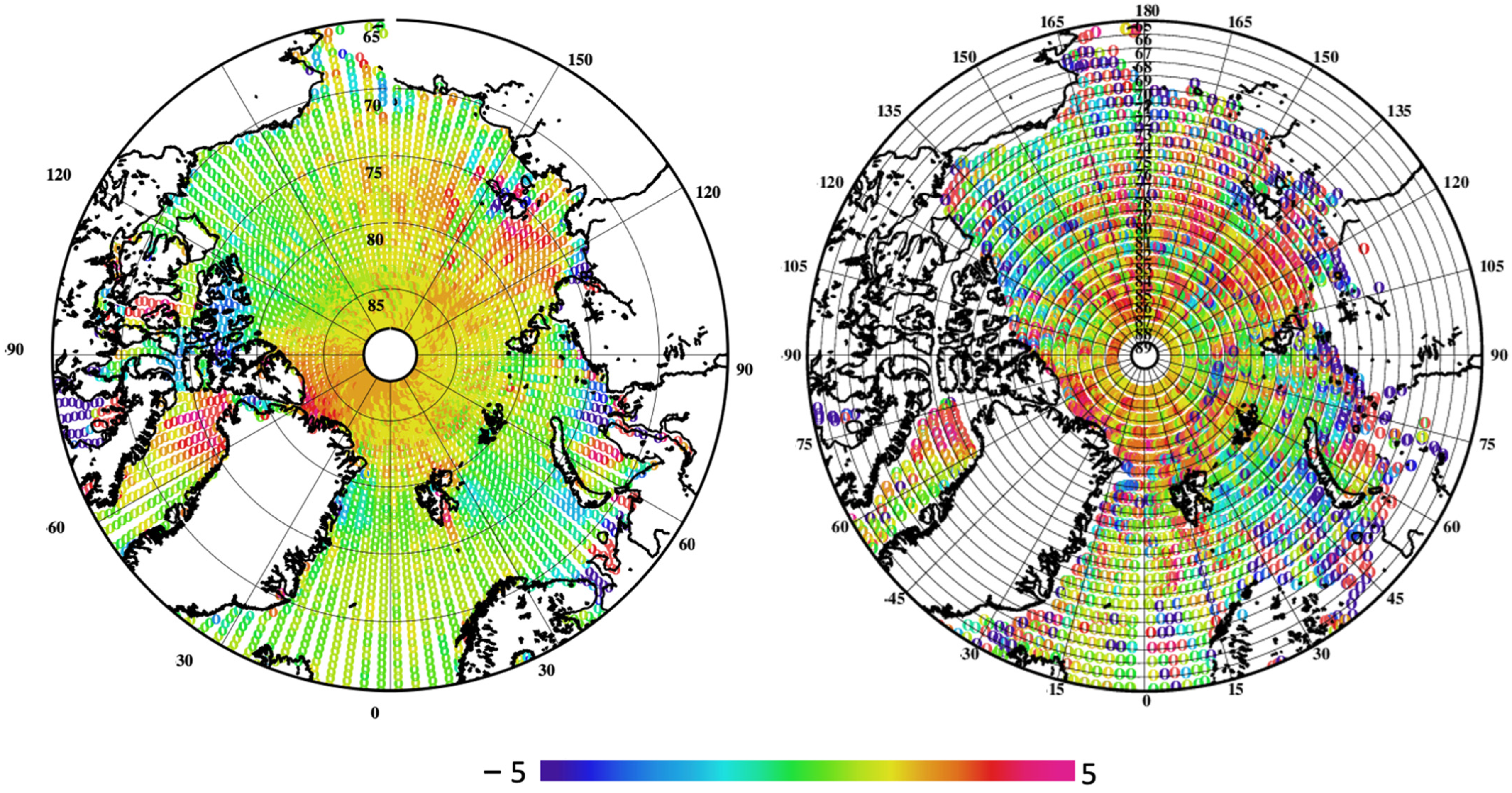
3. Results
4. Evaluation against Tide Gauges
5. Discussion and Conclusions
Author Contributions
Funding
Data Availability Statement
Acknowledgments
Conflicts of Interest
References
- Shum, C.; Woodworth, P.; Andersen, O.; Egbert, G.D.; Francis, O.; King, C.; Klosko, S.; Le Provost, C.; Li, X.; Molines, J.-M.; et al. Accuracy assessment of recent ocean tide models. J. Geophys. Res. Oceans 1997, 102, 25173–25194. [Google Scholar] [CrossRef]
- Stammer, D.; Ray, R.D.; Andersen, O.B.; Arbic, B.K.; Bosch, W.; Carrère, L.; Cheng, Y.; Chinn, D.S.; Dushaw, B.D.; Egbert, G.D.; et al. Accuracy assessment of global barotropic ocean tide models. Rev. Geophys. 2014, 52, 243–282. [Google Scholar] [CrossRef]
- Zaron, E.D. Mapping the non-stationary internal tide with satellite altimetry. J. Geophys. Res. 2017, 122, 539–554. [Google Scholar] [CrossRef]
- Ray, R.D. Precise comparisons of bottom-pressure and altimetric ocean tides. J. Geophys. Res. Ocean. 2013, 118, 4570–4584. [Google Scholar] [CrossRef]
- Hart-Davis, M.G.; Piccioni, G.; Dettmering, D.; Schwatke, C.; Passaro, M.; Seitz, F. EOT20: A global ocean tide model from multi-mission satellite altimetry. Earth Syst. Sci. Data 2021, 13, 3869–3884. [Google Scholar] [CrossRef]
- Andersen, O.B. Global Ocean tides from ERS-1 and TOPEX/POSEIDON altimeter. J. Geophys. Res. 1995, 100, 249–259. [Google Scholar] [CrossRef]
- Cheng, Y.; Andersen, O.B. Multimission empirical ocean tide modeling for shallow waters and polar seas. J. Geophys. Res. 2011, 116, C11001. [Google Scholar] [CrossRef]
- Andersen, O.B. Shallow water tides on the northwest European shelf from TOPEX/POSEIDON altimeter. J. Geophys. Res. 1999, 104, 7729–7741. [Google Scholar] [CrossRef]
- Fu, L.-L.; Cazenave, A. (Eds.) Satellite Altimetry and Earth Sciences: A Handbook of Techniques and Applications; Academic Press: San Diego, CA, USA, 2001; p. 463. [Google Scholar]
- Hart-Davis, M.G.; Dettmering, D.; Sulzbach, R.; Thomas, M.; Schwatke, C.; Seitz, F. Regional Evaluation of Minor Tidal Constituents for Improved Estimation of Ocean Tides. Remote Sens. 2021, 13, 3310. [Google Scholar] [CrossRef]
- Cancet, M.; Andersen, O.; Lyard, F.; Cotton, D.; Benveniste, J. Arctide2017, a high-resolution regional tidal model in the arctic ocean. Adv. Space Res. 2018, 62, 1324–1343. [Google Scholar] [CrossRef]
- Padman, L.; Fricker, H.A.; Coleman, R.; Howard, S.; Erofeeva, S. A new tidal model for the Antarctic ice shelves and seas. Ann. Glaciol. 2002, 34, 247–254. [Google Scholar] [CrossRef]
- Padman, L.; Erofeeva, S.Y.; Fricker, H.A. Improving Antarctic tide models by assimilation of ICESat laser altimetry over ice shelves. Geophys. Res. Lett. 2008, 35, L22504. [Google Scholar] [CrossRef]
- Wingham, D.; Francis, C.; Baker, S.; Bouzinac, C.; Brockley, D.; Cullen, R.; de Chateau-Thierry, P.; Laxon, S.; Mallow, U.; Mavrocordatos, C.; et al. CryoSat: A mission to determine the fluctuations in Earth’s land and marine ice fields. Adv. Space Res. 2006, 37, 841–871. [Google Scholar] [CrossRef]
- Boy, F.; Desjonquères, J.-D.; Picot, N.; Moreau, T.; Raynal, M. CryoSat-2 SAR-mode over oceans: Processing methods, global assessment, and benefits. IEEE Trans. Geosci. Remote Sens. 2017, 55, 148–158. [Google Scholar] [CrossRef]
- Cryosate-2 Mode Mask. Available online: https://earth.esa.int/eogateway/news/new-cryosat-geographical-mode-mask-v5-0-now-in-operation (accessed on 30 June 2023).
- Stenseng, L.; Andersen, O.B. Preliminary gravity recovery from CryoSat-2 data in Baffin Bay, Preliminary gravity recovery from CryoSat-2 data in the Baffin Bay. Adv. Space Res. 2015, 50, 1158–1163. [Google Scholar] [CrossRef]
- Zaron, E.D. Ocean and Ice Shelf Tides from Cryosat-2 Altimetry. Am. Meteorol. Soc. 2018, 48, 975–993. [Google Scholar] [CrossRef]
- Benveniste, J.; Dinardo, S.; Buchhaupt, C.; Scagliola, M.; Passaro, M.; Fenoglio-Marc, L.; Sabatino, G.; Ambrózio, A.; Restano, M. In Proceedings of the SAR, SARin, RDSAR and FF-SAR Altimetry Processing on Demand for CryoSat-2 and Sentinel-3 at ESA G-POD, EGU General Assembly 2021, Online, 19–30 April 2021; 2021. [CrossRef]
- Rose, S.K.; Andersen, O.B.; Passaro, M.; Ludwigsen, C.A.; Schwatke, C. Arctic Ocean Sea Level Record from the Complete Radar Altimetry Era 1991–2018. Rem. Sens. 2019, 11, 1672. [Google Scholar] [CrossRef]
- Piccioni, G.; Dettmering, D.; Passaro, M.; Schwatke, C.; Bosch, W.; Seitz, F. Coastal improvements for tide models: The impact of ALES retracker. Remote Sens. 2018, 10, 700. [Google Scholar] [CrossRef]
- Andersen, O.B.; Scharroo, R. Range and geophysical corrections in coastal regions: And implications for mean sea surface determination. In Coastal Altimetry; Vignudelli, S., Kostianoy, A.G., Cipollini, P., Benveniste, J., Eds.; Springer: Berlin/Heidelberg, Germany, 2011; pp. 103–145. [Google Scholar]
- Dinardo, S.; Fenoglio-Marc, L.; Buchhaupt, C.; Becker, M.; Scharroo, R.; Fernandes, M.J.; Jérôme Benveniste, J. Coastal SAR and PLRM altimetry in German Bight and West Baltic Sea. Adv. Space Res. 2017, 62, 1371–1404. [Google Scholar] [CrossRef]
- Ray, C.; Martin-Puig, C.; Clarizia, M.P.; Runi, G.; Dinardo, S.; Gommenginger, C.; Benveniste, J. SAR altimeter backscattered waveform model. IEEE Trans. Geosci. Rem. Sens. 2015, 53, 911–919. [Google Scholar] [CrossRef]
- Laforge, A.; Fleury, S.; Dinardo, S.; Garnier, F.; Remy, F.; Benveniste, J.; Bouffard, J.; Verley, J. Toward improved sea ice freeboard observation with SAR altimetry using the physical retracker SAMOSA+. Adv. Space Res. 2021, 68, 732–745. [Google Scholar] [CrossRef]
- Fenoglio, L.; Dinardo, S.; Uebbing, B.; Buchhaupt, C.; Gärtner, M.; Staneva, J.; Becker, M.; Klos, A.; Kusche, J. Advances in NE-Atlantic coastal Sea Level Change Monitoring from Delay Doppler Altimetry. Adv. Space Res. 2021, 68, 571–592. [Google Scholar] [CrossRef]
- Andersen, O.B.; Rose, S.K.; Abulaitijiang, A.; Zhang, S.; Fleury, S. The DTU21 Global Mean Sea Surface and first evaluation in the Arctic Ocean. Earth Syst. Sci. Data, 2023; in press. [Google Scholar] [CrossRef]
- Lyard, F.H.; Allain, D.J.; Cancet, M.; Carrère, L.; Picot, N. Fes2014 global ocean tide atlas: Design and performance. Ocean Sci. 2021, 17, 615–649. [Google Scholar] [CrossRef]
- Tran, N.; Labroue, S.; Philipps, S.; Bronner, E. Picot Overview and update of the sea state bias corrections for the Jason-2, Jason-1 and TOPEX missions. Mar. Geod. 2010, 33 (Suppl. S1), 348–362. [Google Scholar] [CrossRef]
- Andersen, O.B.; Knudsen, P. DNSC08 mean sea surface and mean dynamic topography models. J. Geophys. Res. 2009, 114, C11001. [Google Scholar] [CrossRef]
- Scharroo, R.; Leuliette, E.W.; Lillibridge, J.L.; Byrne, D.; Naeije, M.C.; Mitchum, G.T. RADS: Consistent multi-mission products. In Proceedings of the Symposium on 20 Years of Progress in Radar Altimetry, Venice-Lido, Italy, 20–28 September 2012. [Google Scholar]
- Munk, W.H.; Cartwright, D.E. Tidal spectroscopy and prediction. Philos. Trans. R. Soc. Lond. Ser. A 1966, 259, 533–583. [Google Scholar]
- Cartwright, D.E.; Ray, R.D. Oceanic tides from Geosat altimetry. J. Geophys. Res. 1990, 95, 3069–3090. [Google Scholar] [CrossRef]
- Larson, K.M.; Ray, R.D.; Nievinski, F.G.; Freymueller, J.T. The accidental tide gauge: A GPS reflection case study from Kachemak Bay, Alaska. IEEE Geosci. Remote. Sens. Lett. 2013, 10, 1200–1204. [Google Scholar] [CrossRef]
- Andersen, O.B.; Egbert, G.D.; Erofeeva, S.Y.; Ray, R.D. Mapping nonlinear shallow-water tides: A look at the past and future. Ocean Dyn. 2006, 56, 416–429. [Google Scholar] [CrossRef]
- Hart-Davis, M.G.; Dettmering, D.; Seitz, F. TICON-3: Tidal Constants Based on GESLA-3 Sea-Level Records from Globally Distributed Tide Gauges Including Gauge Type Information (Data); PANGAEA: Bremen, Germany, 2022. [Google Scholar] [CrossRef]
- Hart-Davis, M.; Howard, S.; Ray, R.; Andersen, O.; Padman, L.; Nilsen, F.; Dettmering, D. Review. ArcTiCA: Arctic Tidal Constituents Atlas; Arctic Data Center: 2023. Available online: https://www.researchsquare.com/article/rs-3277941/v1 (accessed on 1 July 2023).
- Howard, S.L.; King, M.; Padman, L. Antarctic Tide Gauge Database, 1st ed.; U.S. Antarctic Program (USAP) Data Center: New York, NY, USA, 2020. [Google Scholar] [CrossRef]


| Jason (9.9156-day) | Envisat (35-day) | Sentinel-3 (27-day) | Cryosat-2 (368.24-day) | Cryosat-2 Sub-Cycle (28.331-day) | |
|---|---|---|---|---|---|
| M2 | 62.107480 | 94.486461 | 157.537622 | 800.070025 | 379.709199 |
| S2 | 58.741706 | Infinite | Infinite | 768.318394 | 245.262712 |
| K2 | 86.596122 | 182.621095 | 182.621095 | 742.877694 | 715.022170 |
| N2 | 49.596177 | 97.392957 | 140.982483 | 2095.633360 | 225.422047 |
| K1 | 173.192245 | 365.242190 | 365.242190 | 1485.755387 | 1430.044341 |
| O1 | 45.714180 | 132.806118 | 277.025136 | 1261.5526611 | 294.393753 |
| P1 | 88.890870 | 365.242190 | 365.242190 | 1591.126753 | 209.356579 |
| Q1 | 69.364499 | 132.806118 | 229.612139 | 5105.281211 | 194.726710 |
| M4 | 31.053740 | 135.0055291 | 78.768811 | 4633.024758 | 185.354599 |
| FES14b | Zaron | DTU22 | Harmonic | |
|---|---|---|---|---|
| M2 | 4.38 | 3.1 * | 4.01 (3.2) | 4.15 |
| S2 | 4.31 | 6.6 * | 2.61 (3.8) | 2.65 |
| K1 | 7.57 | 2.9 * | 3.26 (3.1) | 3.30 |
| O1 | 6.52 | 2.0 * | 3.03 (2.0) | 2.88 |
| FES14b | DTU22 | |
|---|---|---|
| M2 | 9.86 | 7.58 |
| S2 | 5.01 | 4.86 |
| K1 | 4.78 | 4.75 |
| O1 | 2.69 | 2.29 |
Disclaimer/Publisher’s Note: The statements, opinions and data contained in all publications are solely those of the individual author(s) and contributor(s) and not of MDPI and/or the editor(s). MDPI and/or the editor(s) disclaim responsibility for any injury to people or property resulting from any ideas, methods, instructions or products referred to in the content. |
© 2023 by the authors. Licensee MDPI, Basel, Switzerland. This article is an open access article distributed under the terms and conditions of the Creative Commons Attribution (CC BY) license (https://creativecommons.org/licenses/by/4.0/).
Share and Cite
Andersen, O.B.; Rose, S.K.; Hart-Davis, M.G. Polar Ocean Tides—Revisited Using Cryosat-2. Remote Sens. 2023, 15, 4479. https://doi.org/10.3390/rs15184479
Andersen OB, Rose SK, Hart-Davis MG. Polar Ocean Tides—Revisited Using Cryosat-2. Remote Sensing. 2023; 15(18):4479. https://doi.org/10.3390/rs15184479
Chicago/Turabian StyleAndersen, Ole Baltazar, Stine Kildegaard Rose, and Michael G. Hart-Davis. 2023. "Polar Ocean Tides—Revisited Using Cryosat-2" Remote Sensing 15, no. 18: 4479. https://doi.org/10.3390/rs15184479