
Geophysics in Antarctic Research: A Bibliometric Analysis

Abstract
:1. Introduction
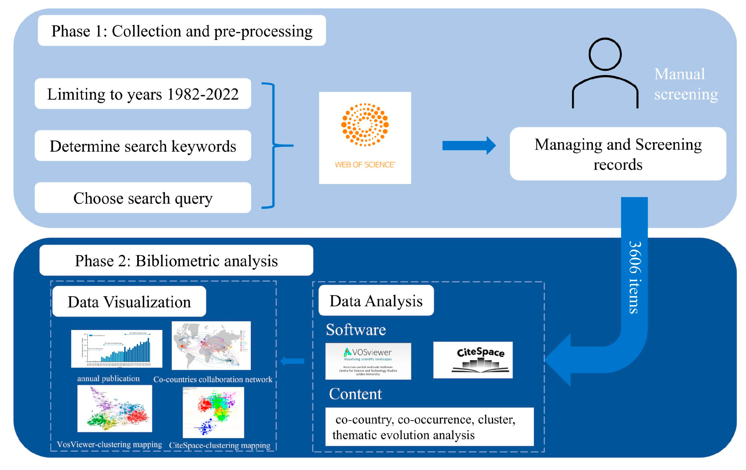
2. Data and Methods
2.1. Data Collection
2.2. Analysis Methods
3. Results and Discussion
3.1. Characteristics of Publication Output
3.2. Research Influence and Cooperation Analysis
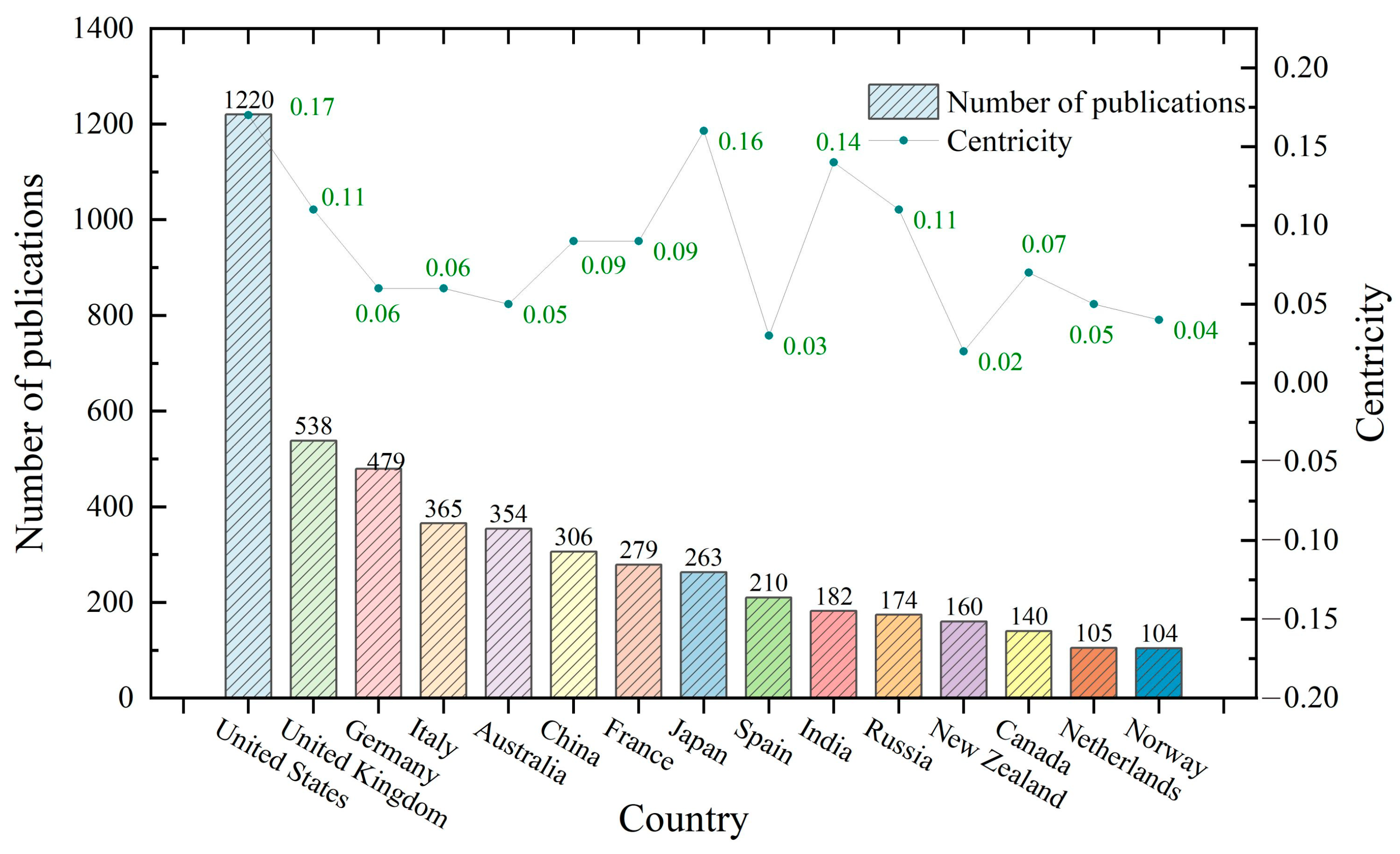
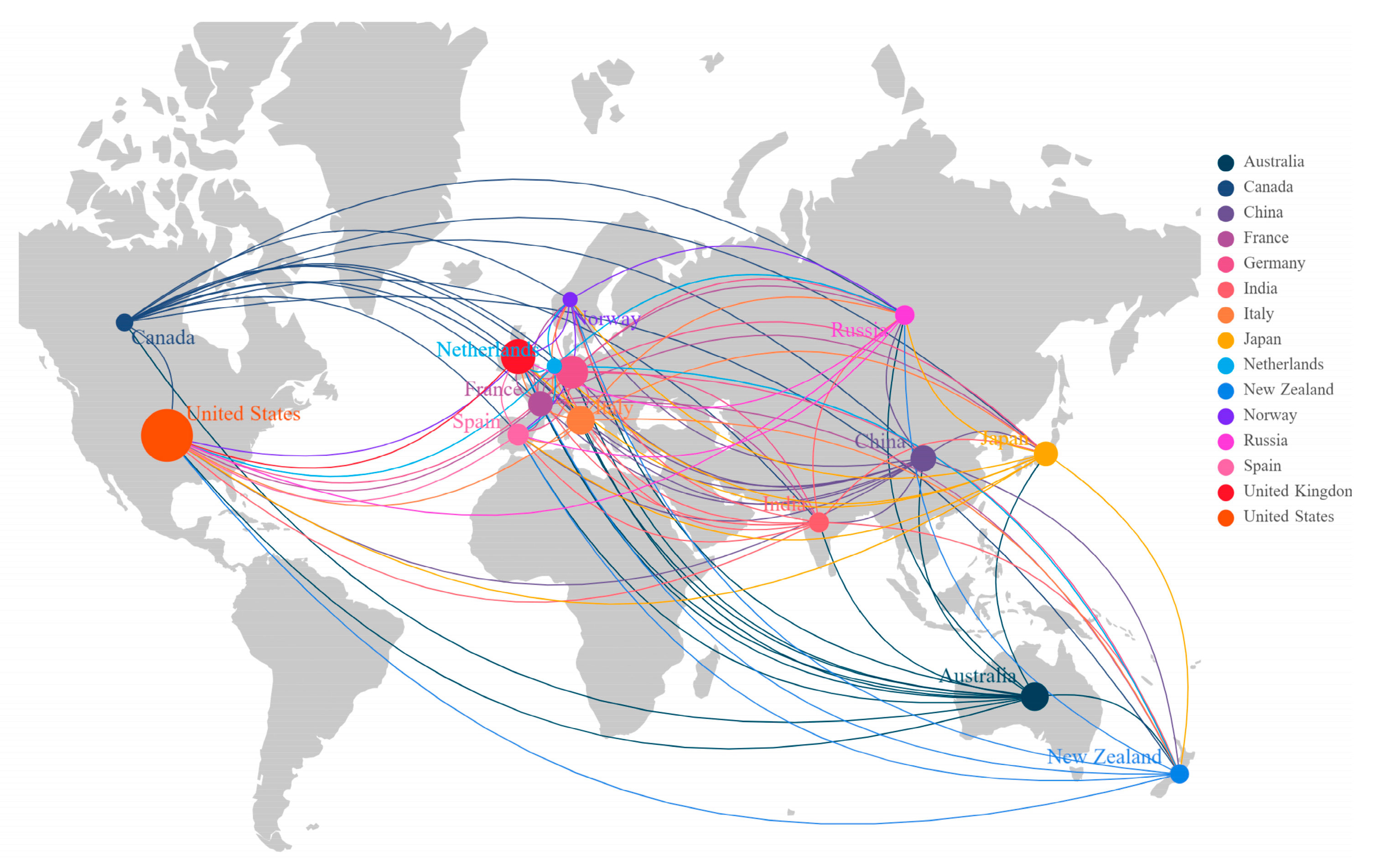
3.2.1. Major Countries and Institutions for Antarctic Geophysical Research
3.2.2. Influence Distribution and Cooperation among Core Countries/Institutions
3.3. Focus on Antarctic Geophysical Research
3.3.1. Antarctic Ice Sheet Instability and Sea Level Change
3.3.2. Southern Ocean and Sea Ice
3.3.3. Tectonic Activity of the West Antarctic Rift System
3.3.4. Paleocontinental Rift and Reorganization
3.3.5. Magmatism and Volcanism
3.3.6. Subglacial Lakes and Subglacial Hydrology
3.4. Theme Evolution in Antarctic Geophysical Research
4. Conclusions
Author Contributions
Funding
Data Availability Statement
Conflicts of Interest
References
- Stokes, C.R.; Abram, N.J.; Bentley, M.J.; Edwards, T.L.; England, M.H.; Foppert, A.; Jamieson, S.S.; Jones, R.S.; King, M.A.; Lenaerts, J.T. Response of the East Antarctic Ice Sheet to past and future climate change. Nature 2022, 608, 275–286. [Google Scholar] [CrossRef] [PubMed]
- Jankowski, E.J.; Drewry, D. The structure of West Antarctica from geophysical studies. Nature 1981, 291, 17–21. [Google Scholar] [CrossRef]
- Claerbout, J.F. Fundamentals of Geophysical Data Processing; McGraw-Hill: New York, NY, USA, 1976; Volume 274. [Google Scholar]
- Franke, S.; Eisermann, H.; Jokat, W.; Eagles, G.; Asseng, J.; Miller, H.; Steinhage, D.; Helm, V.; Eisen, O.; Jansen, D. Preserved landscapes underneath the Antarctic Ice Sheet reveal the geomorphological history of Jutulstraumen Basin. Earth Surf. Process. Landf. 2021, 46, 2728–2745. [Google Scholar] [CrossRef]
- Bo, S.; Siegert, M.J.; Mudd, S.M.; Sugden, D.; Fujita, S.; Xiangbin, C.; Yunyun, J.; Xueyuan, T.; Yuansheng, L. The Gamburtsev mountains and the origin and early evolution of the Antarctic Ice Sheet. Nature 2009, 459, 690–693. [Google Scholar] [CrossRef] [PubMed]
- Morlighem, M.; Rignot, E.; Binder, T.; Blankenship, D.; Drews, R.; Eagles, G.; Eisen, O.; Ferraccioli, F.; Forsberg, R.; Fretwell, P. Deep glacial troughs and stabilizing ridges unveiled beneath the margins of the Antarctic ice sheet. Nat. Geosci. 2020, 13, 132–137. [Google Scholar] [CrossRef] [Green Version]
- Gulick, S.P.; Shevenell, A.E.; Montelli, A.; Fernandez, R.; Smith, C.; Warny, S.; Bohaty, S.M.; Sjunneskog, C.; Leventer, A.; Frederick, B. Initiation and long-term instability of the East Antarctic Ice Sheet. Nature 2017, 552, 225–229. [Google Scholar] [CrossRef] [Green Version]
- Joughin, I.; Alley, R.B. Stability of the West Antarctic ice sheet in a warming world. Nat. Geosci. 2011, 4, 506–513. [Google Scholar] [CrossRef]
- Behrendt, J.C. Petroleum and Mineral Resources of Antarctica; Geological Survey: Washington, DC, USA, 1983.
- Nan, Z.; Grigor’evich, T.P. Antarctic oil and mineral resources: A subject off limits or future reality? Authorea Prepr. 2022. [Google Scholar] [CrossRef]
- Jin, Y.; Lee, M.; Kim, Y.; Nam, S.; Kim, K. Gas hydrate volume estimations on the South Shetland continental margin, Antarctic Peninsula. Antarct. Sci. 2003, 15, 271–282. [Google Scholar] [CrossRef]
- Easterbrook, D. Evidence-Based Climate Science: Data Opposing CO2 Emissions as the Primary Source of Global Warming; Elsevier: Amsterdam, The Netherlands, 2016. [Google Scholar]
- Rohling, E.J.; Grant, K.; Bolshaw, M.; Roberts, A.; Siddall, M.; Hemleben, C.; Kucera, M. Antarctic temperature and global sea level closely coupled over the past five glacial cycles. Nat. Geosci. 2009, 2, 500–504. [Google Scholar] [CrossRef]
- Turner, J.; Bindschadler, R.; Convey, P.; Di Prisco, G.; Fahrbach, E.; Gutt, J.; Hodgson, D.; Mayewski, P.; Summerhayes, C. Antarctic Climate Change and the Environment; SCAR: Cambridgeshire, UK, 2009. [Google Scholar]
- Naylor, S.; Dean, K.; Siegert, M. The IGY and the ice sheet: Surveying Antarctica. J. Hist. Geogr. 2008, 34, 574–595. [Google Scholar] [CrossRef]
- Robin, G.d.Q. Norwegian-British-Swedish Antarctic Expedition, 1949–1952. Polar Rec. 1953, 6, 608–616. [Google Scholar] [CrossRef]
- Robin, G.d.Q. Seismic Shooting and Related Investigations; Norsk Polarinstitut: Tromsø, Norway, 1958. [Google Scholar]
- Siegert, M.J.; Jamieson, S.S.; White, D. Exploration of Subsurface Antarctica: Uncovering Past Changes and Modern Processes; Geological Society: London, UK, 2018; Volume 461, pp. 1–6. [Google Scholar]
- Schroeder, D.M.; Bingham, R.G.; Blankenship, D.D.; Christianson, K.; Eisen, O.; Flowers, G.E.; Karlsson, N.B.; Koutnik, M.R.; Paden, J.D.; Siegert, M.J. Five decades of radioglaciology. Ann. Glaciol. 2020, 61, 1–13. [Google Scholar] [CrossRef] [Green Version]
- Dean, K.; Naylor, S.; Turchetti, S.; Siegert, M. Data in Antarctic science and politics. Soc. Stud. Sci. 2008, 38, 571–604. [Google Scholar] [CrossRef]
- Winter, A.; Steinhage, D.; Creyts, T.T.; Kleiner, T.; Eisen, O. Age stratigraphy in the East Antarctic Ice Sheet inferred from radio-echo sounding horizons. Earth Syst. Sci. Data 2019, 11, 1069–1081. [Google Scholar] [CrossRef] [Green Version]
- Frémand, A.C.; Bodart, J.A.; Jordan, T.A.; Ferraccioli, F.; Robinson, C.; Corr, H.F.; Peat, H.J.; Bingham, R.G.; Vaughan, D.G. British Antarctic Survey’s aerogeophysical data: Releasing 25 years of airborne gravity, magnetic, and radar datasets over Antarctica. Earth Syst. Sci. Data 2022, 14, 3379–3410. [Google Scholar] [CrossRef]
- Huybrechts, P. A 3-D model for the Antarctic ice sheet: A sensitivity study on the glacial-interglacial contrast. Clim. Dyn. 1990, 5, 79–92. [Google Scholar] [CrossRef] [Green Version]
- Funaki, M.; Higashino, S.-I.; Sakanaka, S.; Iwata, N.; Nakamura, N.; Hirasawa, N.; Obara, N.; Kuwabara, M. Small unmanned aerial vehicles for aeromagnetic surveys and their flights in the South Shetland Islands, Antarctica. Polar Sci. 2014, 8, 342–356. [Google Scholar] [CrossRef] [Green Version]
- Lucieer, A.; Robinson, S.; Turner, D.; Harwin, S.; Kelcey, J. Using a micro-UAV for ultra-high resolution multi-sensor observations of Antarctic moss beds. ISPRS Int. Arch. Photogramm. Remote Sens. Spat. Inf. Sci. 2012, XXXIX-B1, 429–433. [Google Scholar] [CrossRef] [Green Version]
- McPhail, S.; Templeton, R.; Pebody, M.; Roper, D.; Morrison, R. Autosub long range AUV missions under the Filchner and Ronne ice shelves in the Weddell sea, Antarctica-an engineering perspective. In Proceedings of the OCEANS 2019-Marseille, Marseille, France, 17–20 June 2019; pp. 1–8. [Google Scholar]
- King, P.; Williams, G.; Coleman, R.; Zürcher, K.; Bowden-Floyd, I.; Ronan, A.; Kaminski, C.; Laframboise, J.-M.; McPhail, S.; Wilkinson, J. Deploying an AUV beneath the Sørsdal Ice Shelf: Recommendations from an expert-panel workshop. In Proceedings of the 2018 IEEE/OES Autonomous Underwater Vehicle Workshop (AUV), Porto, Portugal, 6–9 November 2018; pp. 1–6. [Google Scholar]
- Nederhof, A.J. Bibliometric monitoring of research performance in the social sciences and the humanities: A review. Scientometrics 2006, 66, 81–100. [Google Scholar] [CrossRef]
- Donthu, N.; Kumar, S.; Mukherjee, D.; Pandey, N.; Lim, W.M. How to conduct a bibliometric analysis: An overview and guidelines. J. Bus. Res. 2021, 133, 285–296. [Google Scholar] [CrossRef]
- Adie, R. Earth sciences: The geology of Antarctica: A review. Philos. Trans. R. Soc. Lond. B Biol. Sci. 1977, 279, 123–130. [Google Scholar]
- Fogg, G.E. A History of Antarctic Science; Cambridge University Press: Cambridge, UK, 1992. [Google Scholar]
- Dastidar, P.; Ramachandran, S. Intellectual structure of Antarctic science: A 25-years analysis. Scientometrics 2008, 77, 389–414. [Google Scholar] [CrossRef]
- Ji, Q.; Pang, X.; Zhao, X. A bibliometric analysis of research on Antarctica during 1993–2012. Scientometrics 2014, 101, 1925–1939. [Google Scholar] [CrossRef]
- Pina, P.; Vieira, G. UAVs for science in Antarctica. Remote Sens. 2022, 14, 1610. [Google Scholar] [CrossRef]
- Cobo, M.J.; López-Herrera, A.G.; Herrera-Viedma, E.; Herrera, F. An approach for detecting, quantifying, and visualizing the evolution of a research field: A practical application to the Fuzzy Sets Theory field. J. Informetr. 2011, 5, 146–166. [Google Scholar] [CrossRef]
- Cobo, M.J.; López-Herrera, A.G.; Herrera-Viedma, E.; Herrera, F. Science mapping software tools: Review, analysis, and cooperative study among tools. J. Am. Soc. Inf. Sci. Technol. 2011, 62, 1382–1402. [Google Scholar] [CrossRef]
- Garfield, E. From the science of science to Scientometrics visualizing the history of science with HistCite software. J. Informetr. 2009, 3, 173–179. [Google Scholar] [CrossRef] [Green Version]
- Van Eck, N.; Waltman, L. Software survey: VOSviewer, a computer program for bibliometric mapping. Scientometrics 2010, 84, 523–538. [Google Scholar] [CrossRef] [PubMed] [Green Version]
- Chen, C. Searching for intellectual turning points: Progressive knowledge domain visualization. Proc. Natl. Acad. Sci. USA 2004, 101, 5303–5310. [Google Scholar] [CrossRef]
- Guo, P.; Tian, W.; Li, H.; Zhang, G.; Li, J. Global characteristics and trends of research on construction dust: Based on bibliometric and visualized analysis. Environ. Sci. Pollut. Res. 2020, 27, 37773–37789. [Google Scholar] [CrossRef] [PubMed]
- Chen, C. CiteSpace II: Detecting and visualizing emerging trends and transient patterns in scientific literature. J. Am. Soc. Inf. Sci. Technol. 2006, 57, 359–377. [Google Scholar] [CrossRef] [Green Version]
- Chen, C.; Hu, Z.; Liu, S.; Tseng, H. Emerging trends in regenerative medicine: A scientometric analysis in CiteSpace. Expert Opin. Biol. Ther. 2012, 12, 593–608. [Google Scholar] [CrossRef] [PubMed]
- Li, J.; Chen, C. CiteSpace: Text Mining and Visualization in Scientific Literature; Capital University of Economics and Business Press: Beijing, China, 2016; pp. 149–152. [Google Scholar]
- Duan, P.; Wang, Y.; Yin, P. Remote sensing applications in monitoring of protected areas: A bibliometric analysis. Remote Sens. 2020, 12, 772. [Google Scholar] [CrossRef] [Green Version]
- Kleinberg, J. Bursty and hierarchical structure in streams. In Proceedings of the Eighth ACM SIGKDD International Conference on Knowledge Discovery and Data Mining, Edmonton, AB, Canada, 23–36 July 2002; pp. 91–101. [Google Scholar]
- Xu, T.; Wang, F.; Yi, Q.; Xie, L.; Yao, X. A Bibliometric and Visualized Analysis of Research Progress and Trends in Rice Remote Sensing over the Past 42 Years (1980–2021). Remote Sens. 2022, 14, 3607. [Google Scholar] [CrossRef]
- Brook, E.J.; Buizert, C. Antarctic and global climate history viewed from ice cores. Nature 2018, 558, 200–208. [Google Scholar] [CrossRef]
- Rintoul, S.R.; Chown, S.L.; DeConto, R.M.; England, M.H.; Fricker, H.A.; Masson-Delmotte, V.; Naish, T.R.; Siegert, M.J.; Xavier, J.C. Choosing the future of Antarctica. Nature 2018, 558, 233–241. [Google Scholar] [CrossRef]
- Klages, J.P.; Salzmann, U.; Bickert, T.; Hillenbrand, C.-D.; Gohl, K.; Kuhn, G.; Bohaty, S.M.; Titschack, J.; Müller, J.; Frederichs, T. Temperate rainforests near the South Pole during peak Cretaceous warmth. Nature 2020, 580, 81–86. [Google Scholar] [CrossRef]
- Whitehouse, P.L.; Gomez, N.; King, M.A.; Wiens, D.A. Solid Earth change and the evolution of the Antarctic Ice Sheet. Nat. Commun. 2019, 10, 503. [Google Scholar] [CrossRef] [Green Version]
- Kennicutt, M.C.; Bromwich, D.; Liggett, D.; Njåstad, B.; Peck, L.; Rintoul, S.R.; Ritz, C.; Siegert, M.J.; Aitken, A.; Brooks, C.M. Sustained Antarctic research: A 21st century imperative. One Earth 2019, 1, 95–113. [Google Scholar] [CrossRef] [Green Version]
- Cui, X.; Jeofry, H.; Greenbaum, J.S.; Guo, J.; Li, L.; Lindzey, L.E.; Habbal, F.A.; Wei, W.; Young, D.A.; Ross, N. Bed topography of princess Elizabeth land in east Antarctica. Earth Syst. Sci. Data 2020, 12, 2765–2774. [Google Scholar] [CrossRef]
- Koutnik, M.R.; Fudge, T.; Conway, H.; Waddington, E.D.; Neumann, T.A.; Cuffey, K.M.; Buizert, C.; Taylor, K.C. Holocene accumulation and ice flow near the West Antarctic Ice Sheet Divide ice core site. J. Geophys. Res. Earth Surf. 2016, 121, 907–924. [Google Scholar] [CrossRef] [Green Version]
- Smith, A.; Anker, P.; Nicholls, K.; Makinson, K.; Murray, T.; Rios-Costas, S.; Brisbourne, A.; Hodgson, D.; Schlegel, R.; Anandakrishnan, S. Ice stream subglacial access for ice-sheet history and fast ice flow: The BEAMISH Project on Rutford Ice Stream, West Antarctica and initial results on basal conditions. Ann. Glaciol. 2021, 62, 203–211. [Google Scholar] [CrossRef]
- Ito, K.; Ikami, A. Crustal structure of the Mizuho Plateau, East Antarctica from geophysical data. J. Geodyn. 1986, 6, 285–296. [Google Scholar] [CrossRef]
- Martin, A.; Hartnady, C. Plate tectonic development of the South West Indian Ocean: A revised reconstruction of East Antarctica and Africa. J. Geophys. Res. Solid Earth 1986, 91, 4767–4786. [Google Scholar] [CrossRef]
- Cook, R.A.; Davey, F. The hydrocarbon exploration of the basins of the Ross sea, Antarctica, from modelling of the geophysical data. J. Pet. Geol. 1984, 7, 213–225. [Google Scholar] [CrossRef]
- Dibble, R.; Kienle, J.; Kyle, P.; Shibuya, K. Geophysical studies of Erebus volcano, Antarctica, from 1974 December to 1982 January. N. Z. J. Geol. Geophys. 1984, 27, 425–455. [Google Scholar] [CrossRef]
- Behrendt, J.C.; LeMasurier, W.; Cooper, A.; Tessensohn, F.; Trehu, A.; Damaske, D. Geophysical studies of the West Antarctic rift system. Tectonics 1991, 10, 1257–1273. [Google Scholar] [CrossRef]
- Barr, S.; Lüdecke, C. The History of the International Polar Years (IPYs); Springer: Berlin/Heidelberg, Germany, 2010. [Google Scholar]
- Li, B.; Si, G.; Ding, J.; Wang, F. A faster algorithm to calculate centrality based on Shortest Path Layer. In Proceedings of the 2017 29th Chinese Control and Decision Conference (CCDC), Chongqing, China, 28–30 May 2017; pp. 6283–6290. [Google Scholar]
- Puzis, R.; Zilberman, P.; Elovici, Y.; Dolev, S.; Brandes, U. Heuristics for speeding up betweenness centrality computation. In Proceedings of the 2012 International Conference on Privacy, Security, Risk and Trust and 2012 International Confernece on Social Computing, Amsterdam, The Netherlands, 3–5 September 2012; pp. 302–311. [Google Scholar]
- Chen, L.; Liu, X.; Bian, L.; Chen, B.; Huang, H.; Hu, H.; Luo, W.; Shi, G.; Shi, J.; Xu, C. Overview of China’s Antarctic research progress 1984–2016. Adv. Polar Sci. 2017, 28, 151–160. [Google Scholar] [CrossRef]
- Gao, J.; Shen, Z.; Yang, C.; Wang, W.; Ji, F.; Wu, Z.; Niu, X.; Ding, W.; Li, D.; Zhang, Q. Progress in Antarctic marine geophysical research by the Chinese Polar Program. Adv. Polar Sci. 2017, 28, 256–267. [Google Scholar]
- Cui, X.; Greenbaum, J.S.; Lang, S.; Zhao, X.; Li, L.; Guo, J.; Sun, B. The scientific operations of Snow Eagle 601 in Antarctica in the past five austral seasons. Remote Sens. 2020, 12, 2994. [Google Scholar] [CrossRef]
- Cui, X.; Greenbaum, J.S.; Beem, L.H.; Guo, J.; Ng, G.; Li, L.; Blankenship, D.; Sun, B. The first fixed-wing aircraft for Chinese Antarctic expeditions: Airframe, modifications, scientific instrumentation and applications. J. Environ. Eng. Geophys. 2018, 23, 1–13. [Google Scholar] [CrossRef]
- The University of Texas. Available online: https://ig.utexas.edu/polar-and-planetary/ (accessed on 18 June 2023).
- Niu, Y.; Zhang, S.; Zhao, J.; Xiong, Y.; Wu, X. Comprehensive evaluation and analysis of the international polar research from 2010 to 2016. J. Glaciol. Geocryol. 2017, 39, 1039–1046. [Google Scholar]
- Helmholtz. Available online: https://www.helmholtz.de/en/about-us/helmholtz-centers/centers-a-z/centre/alfred-wegener-institute-helmholtz-centre-for-polar-and-marine-research-awi/ (accessed on 16 June 2023).
- UK Research and Innovation. Available online: https://www.ukri.org/news/uk-invests-to-modernise-polar-science/ (accessed on 16 June 2023).
- UK Research and Innovation. Available online: https://www.ukri.org/about-us/nerc/who-we-are/nerc-research-centres/ (accessed on 7 December 2022).
- Erb, K.A. International collaboration in the Antarctic for global science. Sci. Dipl. Antarct. Sci. Gov. Int. Spaces 2011, 77, 265–270. [Google Scholar]
- Lüdecke, C. Scientific collaboration in Antarctica (1901–04): A challenge in times of political rivalry. Polar Rec. 2003, 39, 35–48. [Google Scholar] [CrossRef]
- Walton, D.W.; Kennicutt, M.C.; Summerhayes, C.P. Antarctic Scientific Collaboration: The Role of the SCAR. In Exploring the Last Continent: An Introduction to Antarctica; Springer: Berlin/Heidelberg, Germany, 2015; pp. 573–588. [Google Scholar]
- Jamieson, S.S.; Ross, N.; Greenbaum, J.S.; Young, D.A.; Aitken, A.R.; Roberts, J.L.; Blankenship, D.D.; Bo, S.; Siegert, M.J. An extensive subglacial lake and canyon system in Princess Elizabeth Land, East Antarctica. Geology 2016, 44, 87–90. [Google Scholar] [CrossRef] [Green Version]
- Tang, X.; Sun, B. Towards an integrated study of subglacial conditions in Princess Elizabeth Land, East Antarctica. Adv. Polar Sci 2021, 32, 75–77. [Google Scholar]
- Greenbaum, J.; Blankenship, D.; Young, D.; Richter, T.; Roberts, J.; Aitken, A.; Legresy, B.; Schroeder, D.; Warner, R.; Van Ommen, T. Ocean access to a cavity beneath Totten Glacier in East Antarctica. Nat. Geosci. 2015, 8, 294–298. [Google Scholar] [CrossRef]
- Tang, X. 2021 international symposium on “Instability and Thresholds in Antarctica (INSTANT)”, Scientific Committee on Antarctic Research (SCAR). Chin. J. Polar Res. 2021, 33, 309. [Google Scholar]
- Siegert, M.; Florindo, F.; De Santis, L.; Naish, T.R. The future evolution of Antarctic climate: Conclusions and upcoming programmes. In Antarctic Climate Evolution; Elsevier: Amsterdam, The Netherlands, 2022; pp. 769–775. [Google Scholar]
- Brooks, S.M.; Becker, T.M.; Baillie, K.; Becker, H.N.; Bradley, E.T.; Colwell, J.E.; Cuzzi, J.; De Pater, I.; Eckert, S.; Elmoutamid, M. Frontiers in Planetary Rings Science. Bull. Am. Astron. Soc. 2021, 53, 258. [Google Scholar]
- Cavitte, M.G.; Young, D.A.; Mulvaney, R.; Ritz, C.; Greenbaum, J.S.; Ng, G.; Kempf, S.D.; Quartini, E.; Muldoon, G.R.; Paden, J. A detailed radiostratigraphic data set for the central East Antarctic Plateau spanning from the Holocene to the mid-Pleistocene. Earth Syst. Sci. Data 2021, 13, 4759–4777. [Google Scholar] [CrossRef]
- Sutter, J.; Fischer, H.; Eisen, O. Investigating the internal structure of the Antarctic ice sheet: The utility of isochrones for spatiotemporal ice-sheet model calibration. Cryosphere 2021, 15, 3839–3860. [Google Scholar] [CrossRef]
- Delf, R.; Schroeder, D.M.; Curtis, A.; Giannopoulos, A.; Bingham, R.G. A comparison of automated approaches to extracting englacial-layer geometry from radar data across ice sheets. Ann. Glaciol. 2020, 61, 234–241. [Google Scholar] [CrossRef]
- Young, D.A.; Greenbaum, J.S.; Blankenship, D.D.; Siegert, M.J.; Roberts, J.L.; van Ommen, T.D.; Aitken, A.; Grima, C.; Le Meur, E. ICECAP’s contribution to NASA’s Operation IceBridge in East Antarctica. In Proceedings of the AGU Fall Meeting Abstracts, San Francisco, CA, USA, 9–13 December 2019; p. C31C-1562. [Google Scholar]
- Wei, W.; Greenbaum, J.S.; Gourmelen, N.; Dow, C.F.; Bo, S.; Guo, J.; van Ommen, T.D.; Roberts, J.L.; Young, D.A.; Blankenship, D.D. The bathymetric and subglacial hydrological context for basal melting of the West Ice Shelf in East Antarctica. In Proceedings of the AGU Fall Meeting Abstracts, Washington, DC, USA, 10–14 December 2018; p. C21C-1355. [Google Scholar]
- Golynsky, A.; Bell, R.; Blankenship, D.; Damaske, D.; Ferraccioli, F.; Finn, C.; Golynsky, D.; Ivanov, S.; Jokat, W.; Masolov, V. Air and shipborne magnetic surveys of the Antarctic into the 21st century. Tectonophysics 2013, 585, 3–12. [Google Scholar] [CrossRef] [Green Version]
- Kim, H.; Golynsky, A.; Golynsky, D.; Yu, H.; von Frese, R.; Hong, J. New magnetic anomaly constraints on the Antarctic crust. J. Geophys. Res. Solid Earth 2022, 127, e2021JB023329. [Google Scholar] [CrossRef]
- Fretwell, P.; Pritchard, H.D.; Vaughan, D.G.; Bamber, J.L.; Barrand, N.E.; Bell, R.; Bianchi, C.; Bingham, R.; Blankenship, D.D.; Casassa, G. Bedmap2: Improved ice bed, surface and thickness datasets for Antarctica. Cryosphere 2013, 7, 375–393. [Google Scholar] [CrossRef] [Green Version]
- Scheinert, M.; Ferraccioli, F.; Schwabe, J.; Bell, R.; Studinger, M.; Damaske, D.; Jokat, W.; Aleshkova, N.; Jordan, T.; Leitchenkov, G. New Antarctic gravity anomaly grid for enhanced geodetic and geophysical studies in Antarctica. Geophys. Res. Lett. 2016, 43, 600–610. [Google Scholar] [CrossRef] [Green Version]
- Wiens, D.; Wilson, T.; Dietrich, R. POLENET: Polar Earth Observing Network for the International Polar Year. In Proceedings of the AGU Fall Meeting Abstracts, San Francisco, CA, USA, 10–14 December 2007; p. U24D-03. [Google Scholar]
- Wilson, T.; Wiens, D.; Smalley, B.; Raymond, C.; Nyblade, A.; Huerta, A.; Dalziel, I.; Bevis, M.; Aster, R.; Anandakrishnan, S. POLENET seismic and GPS network in West Antarctica. In Proceedings of the AGU Fall Meeting Abstracts, San Francisco, CA, USA, 15–19 December 2008; p. V11F-02. [Google Scholar]
- Ferraccioli, F.; Finn, C.A.; Jordan, T.A.; Bell, R.E.; Anderson, L.M.; Damaske, D. East Antarctic rifting triggers uplift of the Gamburtsev Mountains. Nature 2011, 479, 388–392. [Google Scholar] [CrossRef]
- MacGregor, J.A.; Boisvert, L.N.; Medley, B.; Petty, A.A.; Harbeck, J.P.; Bell, R.E.; Blair, J.B.; Blanchard-Wrigglesworth, E.; Buckley, E.M.; Christoffersen, M.S. The scientific legacy of NASA’s Operation IceBridge. Rev. Geophys. 2021, 59, e2020RG000712. [Google Scholar] [CrossRef]
- Kurtz, N.; Farrell, S.; Studinger, M.; Galin, N.; Harbeck, J.; Lindsay, R.; Onana, V.; Panzer, B.; Sonntag, J. Sea ice thickness, freeboard, and snow depth products from Operation IceBridge airborne data. Cryosphere 2013, 7, 1035–1056. [Google Scholar] [CrossRef] [Green Version]
- Farrell, S.L.; Kurtz, N.; Connor, L.N.; Elder, B.C.; Leuschen, C.; Markus, T.; McAdoo, D.C.; Panzer, B.; Richter-Menge, J.; Sonntag, J.G. A first assessment of IceBridge snow and ice thickness data over Arctic sea ice. IEEE Trans. Geosci. Remote Sens. 2011, 50, 2098–2111. [Google Scholar] [CrossRef]
- Studinger, M.; Koenig, L.; Martin, S.; Sonntag, J. Operation icebridge: Using instrumented aircraft to bridge the observational gap between Icesat and Icesat-2. In Proceedings of the 2010 IEEE International Geoscience and Remote Sensing Symposium, Honolulu, HI, USA, 25–30 July 2010; pp. 1918–1919. [Google Scholar]
- Kurtz, N.T.; Farrell, S.L. Large-scale surveys of snow depth on Arctic sea ice from Operation IceBridge. Geophys. Res. Lett. 2011, 38, L20505. [Google Scholar] [CrossRef]
- Zhang, Q.; Wang, Y. Zhongguo nanji kaocha 28 nian lai de jinzhan [Antarctic research progress of China in the past 28 years]. Ziran Zazhi 2008, 30, 252–258. [Google Scholar]
- Montemurro, M.A.; Zanette, D.H. Keywords and co-occurrence patterns in the Voynich manuscript: An information-theoretic analysis. PLoS ONE 2013, 8, e66344. [Google Scholar] [CrossRef] [PubMed] [Green Version]
- Rignot, E.; Mouginot, J.; Scheuchl, B.; Van Den Broeke, M.; Van Wessem, M.J.; Morlighem, M. Four decades of Antarctic Ice Sheet mass balance from 1979–2017. Proc. Natl. Acad. Sci. USA 2019, 116, 1095–1103. [Google Scholar] [CrossRef] [Green Version]
- Alley, R.B.; Blankenship, D.D.; Bentley, C.R.; Rooney, S. Deformation of till beneath ice stream B, West Antarctica. Nature 1986, 322, 57–59. [Google Scholar] [CrossRef]
- Kennicutt, M.C.; Chown, S.L.; Cassano, J.J.; Liggett, D.; Massom, R.; Peck, L.S.; Rintoul, S.R.; Storey, J.W.; Vaughan, D.G.; Wilson, T.J. Polar research: Six priorities for Antarctic science. Nature 2014, 512, 23–25. [Google Scholar] [CrossRef] [Green Version]
- Pörtner, H.-O.; Roberts, D.C.; Masson-Delmotte, V.; Zhai, P.; Tignor, M.; Poloczanska, E.; Weyer, N. The Ocean and Cryosphere in a Changing Climate; IPCC: Geneva, Switzerland, 2019; Volume 1155. [Google Scholar]
- Allison, I.; Alley, R.; Fricker, H.; Thomas, R.; Warner, R. Ice sheet mass balance and sea level. Antarct. Sci. 2009, 21, 413–426. [Google Scholar] [CrossRef] [Green Version]
- Kennicutt, M.C.; Chown, S.L.; Cassano, J.J.; Liggett, D.; Peck, L.S.; Massom, R.; Rintoul, S.; Storey, J.; Vaughan, D.; Wilson, T. A roadmap for Antarctic and Southern Ocean science for the next two decades and beyond. Antarct. Sci. 2015, 27, 3–18. [Google Scholar] [CrossRef] [Green Version]
- Treuer, G.A. The psychology of Miami’s struggle to adapt to sea-level rise. Bull. At. Sci. 2018, 74, 155–159. [Google Scholar] [CrossRef]
- Siegert, M.J.; Kulessa, B.; Bougamont, M.; Christoffersen, P.; Key, K.; Andersen, K.R.; Booth, A.D.; Smith, A.M. Antarctic subglacial groundwater: A concept paper on its measurement and potential influence on ice flow. Geol. Soc. Lond. Spec. Publ. 2018, 461, 197–213. [Google Scholar] [CrossRef]
- Yang, T.; Liang, Q.; Zheng, L.; Li, T.; Chen, Z.; Hui, F.; Cheng, X. Mass Balance of the Antarctic Ice Sheet in the Early 21st Century. Remote Sens. 2023, 15, 1677. [Google Scholar] [CrossRef]
- Van den Broeke, M.R.; Bamber, J.; Lenaerts, J.; Rignot, E. Ice sheets and sea level: Thinking outside the box. Surv. Geophys. 2011, 32, 495–505. [Google Scholar] [CrossRef]
- Rémy, F.; Parouty, S. Antarctic ice sheet and radar altimetry: A review. Remote Sens. 2009, 1, 1212–1239. [Google Scholar] [CrossRef] [Green Version]
- Yu, A.; Shi, H.; Wang, Y.; Yang, J.; Gao, C.; Lu, Y. A Bibliometric and Visualized Analysis of Remote Sensing Methods for Glacier Mass Balance Research. Remote Sens. 2023, 15, 1425. [Google Scholar] [CrossRef]
- Velicogna, I. Increasing rates of ice mass loss from the Greenland and Antarctic ice sheets revealed by GRACE. Geophys. Res. Lett. 2009, 36, L19503. [Google Scholar] [CrossRef] [Green Version]
- Velicogna, I.; Wahr, J. Acceleration of Greenland ice mass loss in spring 2004. Nature 2006, 443, 329–331. [Google Scholar] [CrossRef] [Green Version]
- Velicogna, I.; Wahr, J. Measurements of time-variable gravity show mass loss in Antarctica. Science 2006, 311, 1754–1756. [Google Scholar] [CrossRef] [Green Version]
- Chen, J.; Wilson, C.; Blankenship, D.; Tapley, B. Accelerated Antarctic ice loss from satellite gravity measurements. Nat. Geosci. 2009, 2, 859–862. [Google Scholar] [CrossRef]
- Pritchard, H.D.; Arthern, R.J.; Vaughan, D.G.; Edwards, L.A. Extensive dynamic thinning on the margins of the Greenland and Antarctic ice sheets. Nature 2009, 461, 971–975. [Google Scholar] [CrossRef] [PubMed]
- Riva, R.E.; Gunter, B.C.; Urban, T.J.; Vermeersen, B.L.; Lindenbergh, R.C.; Helsen, M.M.; Bamber, J.L.; van de Wal, R.S.; van den Broeke, M.R.; Schutz, B.E. Glacial isostatic adjustment over Antarctica from combined ICESat and GRACE satellite data. Earth Planet. Sci. Lett. 2009, 288, 516–523. [Google Scholar] [CrossRef]
- Noble, T.; Rohling, E.; Aitken, A.; Bostock, H.; Chase, Z.; Gomez, N.; Jong, L.; King, M.A.; Mackintosh, A.; McCormack, F. The sensitivity of the Antarctic ice sheet to a changing climate: Past, present, and future. Rev. Geophys. 2020, 58, e2019RG000663. [Google Scholar] [CrossRef]
- Jawak, S.D.; Luis, A.J.; Pandit, P.H.; Wankhede, S.F.; Convey, P.; Fretwell, P.T. Exploratory Mapping of Blue Ice Regions in Antarctica Using Very High-Resolution Satellite Remote Sensing Data. Remote Sens. 2023, 15, 1287. [Google Scholar] [CrossRef]
- Martin-Español, A.; Bamber, J.L.; Zammit-Mangion, A. Constraining the mass balance of East Antarctica. Geophys. Res. Lett. 2017, 44, 4168–4175. [Google Scholar] [CrossRef] [Green Version]
- Zwally, H.J.; Li, J.; Robbins, J.W.; Saba, J.L.; Yi, D.; Brenner, A.C. Mass gains of the Antarctic ice sheet exceed losses. J. Glaciol. 2015, 61, 1019–1036. [Google Scholar] [CrossRef] [Green Version]
- Bamber, J.L.; Westaway, R.M.; Marzeion, B.; Wouters, B. The land ice contribution to sea level during the satellite era. Environ. Res. Lett. 2018, 13, 063008. [Google Scholar] [CrossRef]
- Gardner, A.S.; Moholdt, G.; Scambos, T.; Fahnstock, M.; Ligtenberg, S.; Van Den Broeke, M.; Nilsson, J. Increased West Antarctic and unchanged East Antarctic ice discharge over the last 7 years. Cryosphere 2018, 12, 521–547. [Google Scholar] [CrossRef] [Green Version]
- Luthcke, S.B.; Sabaka, T.; Loomis, B.; Arendt, A.; McCarthy, J.; Camp, J. Antarctica, Greenland and Gulf of Alaska land-ice evolution from an iterated GRACE global mascon solution. J. Glaciol. 2013, 59, 613–631. [Google Scholar] [CrossRef]
- Rignot, E.; Mouginot, J.; Morlighem, M.; Seroussi, H.; Scheuchl, B. Widespread, rapid grounding line retreat of Pine Island, Thwaites, Smith, and Kohler glaciers, West Antarctica, from 1992 to 2011. Geophys. Res. Lett. 2014, 41, 3502–3509. [Google Scholar] [CrossRef] [Green Version]
- Pritchard, H.; Ligtenberg, S.R.; Fricker, H.A.; Vaughan, D.G.; van den Broeke, M.R.; Padman, L. Antarctic ice-sheet loss driven by basal melting of ice shelves. Nature 2012, 484, 502–505. [Google Scholar] [CrossRef]
- Turner, J.; Orr, A.; Gudmundsson, G.H.; Jenkins, A.; Bingham, R.G.; Hillenbrand, C.D.; Bracegirdle, T.J. Atmosphere-ocean-ice interactions in the Amundsen Sea embayment, West Antarctica. Rev. Geophys. 2017, 55, 235–276. [Google Scholar] [CrossRef] [Green Version]
- Shepherd, A.; Ivins, E.R.; Barletta, V.R.; Bentley, M.J.; Bettadpur, S.; Briggs, K.H.; Bromwich, D.H.; Forsberg, R.; Galin, N.; Horwath, M. A reconciled estimate of ice-sheet mass balance. Science 2012, 338, 1183–1189. [Google Scholar] [CrossRef] [Green Version]
- Shen, Q.; Wang, H.; Shum, C.; Jiang, L.; Hsu, H.T.; Dong, J. Recent high-resolution Antarctic ice velocity maps reveal increased mass loss in Wilkes Land, East Antarctica. Sci. Rep. 2018, 8, 4477. [Google Scholar] [CrossRef] [PubMed] [Green Version]
- McMillan, M.; Shepherd, A.; Sundal, A.; Briggs, K.; Muir, A.; Ridout, A.; Hogg, A.; Wingham, D. Increased ice losses from Antarctica detected by CryoSat-2. Geophys. Res. Lett. 2014, 41, 3899–3905. [Google Scholar] [CrossRef]
- Li, X.; Rignot, E.; Mouginot, J.; Scheuchl, B. Ice flow dynamics and mass loss of Totten Glacier, East Antarctica, from 1989 to 2015. Geophys. Res. Lett. 2016, 43, 6366–6373. [Google Scholar] [CrossRef]
- Velicogna, I.; Sutterley, T.C.; Van Den Broeke, M.R. Regional acceleration in ice mass loss from Greenland and Antarctica using GRACE time-variable gravity data. Geophys. Res. Lett. 2014, 41, 8130–8137. [Google Scholar] [CrossRef] [Green Version]
- Meredith, M.P.; Brandon, M.A. Oceanography and Sea Ice in the Southern Ocean; John Wiley & Sons, Ltd.: Chichester, UK, 2017. [Google Scholar]
- Shepherd, A.; Fricker, H.A.; Farrell, S.L. Trends and connections across the Antarctic cryosphere. Nature 2018, 558, 223–232. [Google Scholar] [CrossRef]
- Ozsoy-Cicek, B.; Ackley, S.; Xie, H.; Yi, D.; Zwally, J. Sea ice thickness retrieval algorithms based on in situ surface elevation and thickness values for application to altimetry. J. Geophys. Res. Ocean. 2013, 118, 3807–3822. [Google Scholar] [CrossRef]
- Kern, S.; Ozsoy-Çiçek, B.; Worby, A.P. Antarctic sea-ice thickness retrieval from ICESat: Inter-comparison of different approaches. Remote Sens. 2016, 8, 538. [Google Scholar] [CrossRef] [Green Version]
- Zwally, H.J.; Parkinson, C.L.; Comiso, J.C. Variability of Antarctic Sea ice: And changes in carbon dioxide. Science 1983, 220, 1005–1012. [Google Scholar] [CrossRef]
- Simmonds, I.; Li, M. Trends and variability in polar sea ice, global atmospheric circulations, and baroclinicity. Ann. N. Y. Acad. Sci. 2021, 1504, 167–186. [Google Scholar] [CrossRef] [PubMed]
- Turner, J.; Guarino, M.V.; Arnatt, J.; Jena, B.; Marshall, G.J.; Phillips, T.; Bajish, C.; Clem, K.; Wang, Z.; Andersson, T. Recent decrease of summer sea ice in the Weddell Sea, Antarctica. Geophys. Res. Lett. 2020, 47, e2020GL087127. [Google Scholar] [CrossRef]
- Serreze, M.C.; Meier, W.N. The Arctic’s sea ice cover: Trends, variability, predictability, and comparisons to the Antarctic. Ann. N. Y. Acad. Sci. 2019, 1436, 36–53. [Google Scholar] [CrossRef] [PubMed]
- Zwally, H.J.; Yi, D.; Kwok, R.; Zhao, Y. ICESat measurements of sea ice freeboard and estimates of sea ice thickness in the Weddell Sea. J. Geophys. Res. Ocean. 2008, 113, C02S15. [Google Scholar] [CrossRef] [Green Version]
- Kurtz, N.T.; Markus, T. Satellite observations of Antarctic sea ice thickness and volume. J. Geophys. Res. Ocean. 2012, 117, C08025. [Google Scholar] [CrossRef] [Green Version]
- Gloersen, P.; Campbell, W.J.; Cavalieri, D.J.; Comiso, J.C.; Parkinson, C.L.; Zwally, H.J. Satellite passive microwave observations and analysis of Arctic and Antarctic sea ice, 1978–1987. Ann. Glaciol. 1993, 17, 149–154. [Google Scholar] [CrossRef] [Green Version]
- Heil, P.; Fowler, C.; Lake, S. Antarctic sea-ice velocity as derived from SSM/I imagery. Ann. Glaciol. 2006, 44, 361–366. [Google Scholar] [CrossRef] [Green Version]
- Holland, P.R.; Kwok, R. Wind-driven trends in Antarctic sea-ice drift. Nat. Geosci. 2012, 5, 872–875. [Google Scholar] [CrossRef]
- Massom, R.A.; Stammerjohn, S.E. Antarctic sea ice change and variability–physical and ecological implications. Polar Sci. 2010, 4, 149–186. [Google Scholar] [CrossRef] [Green Version]
- Turner, J.; Holmes, C.; Caton Harrison, T.; Phillips, T.; Jena, B.; Reeves-Francois, T.; Fogt, R.; Thomas, E.R.; Bajish, C. Record low Antarctic sea ice cover in February 2022. Geophys. Res. Lett. 2022, 49, e2022GL098904. [Google Scholar] [CrossRef]
- Fogt, R.L.; Sleinkofer, A.M.; Raphael, M.N.; Handcock, M.S. A regime shift in seasonal total Antarctic sea ice extent in the twentieth century. Nat. Clim. Change 2022, 12, 54–62. [Google Scholar] [CrossRef]
- Wang, S.; Liu, J.; Cheng, X.; Yang, D.; Kerzenmacher, T.; Li, X.; Hu, Y.; Braesicke, P. Contribution of the deepened Amundsen sea low to the record low Antarctic sea ice extent in February 2022. Environ. Res. Lett. 2023, 18, 054002. [Google Scholar] [CrossRef]
- Sun, S.; Eisenman, I. Observed Antarctic sea ice expansion reproduced in a climate model after correcting biases in sea ice drift velocity. Nat. Commun. 2021, 12, 1060. [Google Scholar] [CrossRef] [PubMed]
- Dalziel, I.; Lawver, L. The lithospheric setting of the West Antarctic ice sheet. West Antarct. Ice Sheet Behav. Environ. 2001, 77, 29–44. [Google Scholar]
- Jordan, T.A.; Riley, T.R.; Siddoway, C.S. The geological history and evolution of West Antarctica. Nat. Rev. Earth Environ. 2020, 1, 117–133. [Google Scholar] [CrossRef] [Green Version]
- Cande, S.C.; Stock, J.M.; Müller, R.D.; Ishihara, T. Cenozoic motion between east and west Antarctica. Nature 2000, 404, 145–150. [Google Scholar] [CrossRef]
- Behrendt, J.C. Crustal and lithospheric structure of the West Antarctic Rift System from geophysical investigations—A review. Glob. Planet. Change 1999, 23, 25–44. [Google Scholar] [CrossRef]
- Behrendt, J.; LeMasurier, W.; Cooper, A.; Tessensohn, F.; Trehu, A.; Damaske, D. The West Antarctic rift system: A review of geophysical investigations. Contrib. Antarct. Res. II 1991, 53, 67–112. [Google Scholar]
- Joughin, I.; Smith, B.E.; Medley, B. Marine ice sheet collapse potentially under way for the Thwaites Glacier Basin, West Antarctica. Science 2014, 344, 735–738. [Google Scholar] [CrossRef]
- Oppenheimer, M. Global warming and the stability of the West Antarctic Ice Sheet. Nature 1998, 393, 325–332. [Google Scholar] [CrossRef]
- Afonso, J.C.; Fullea, J.; Yang, Y.; Connolly, J.; Jones, A. 3-D multi-observable probabilistic inversion for the compositional and thermal structure of the lithosphere and upper mantle. II: General methodology and resolution analysis. J. Geophys. Res. Solid Earth 2013, 118, 1650–1676. [Google Scholar] [CrossRef] [Green Version]
- Lösing, M.; Ebbing, J.; Szwillus, W. Geothermal heat flux in Antarctica: Assessing models and observations by Bayesian inversion. Front. Earth Sci. 2020, 8, 105. [Google Scholar] [CrossRef] [Green Version]
- Whitehouse, P.L.; Bentley, M.J.; Milne, G.A.; King, M.A.; Thomas, I.D. A new glacial isostatic adjustment model for Antarctica: Calibrated and tested using observations of relative sea-level change and present-day uplift rates. Geophys. J. Int. 2012, 190, 1464–1482. [Google Scholar] [CrossRef] [Green Version]
- Winberry, J.P.; Anandakrishnan, S. Crustal structure of the West Antarctic rift system and Marie Byrd Land hotspot. Geology 2004, 32, 977–980. [Google Scholar] [CrossRef]
- Cooper, A.K.; Barker, P.F.; Brancolini, G.; Hambrey, M. Geology and Seismic Stratigraphy of the Antarctic Margin; American Geophysical Union: Washington, DC, USA, 1995; Volume 68. [Google Scholar]
- Gohl, K.; Teterin, D.; Eagles, G.; Netzeband, G.; Grobys, J.; Parsiegla, N.; Schlüter, P.; Leinweber, V.T.; Larter, R.D.; Uenzelmann-Neben, G. Geophysical Survey Reveals Tectonic Structures in the Amundsen Sea Embayment. In Proceedings of the 10th International Symposium on Antarctic Earth Sciences (USGS of-2007-1047), Washington, DC, USA, 26 August–1 September 2007. Short Research Paper 047. [Google Scholar]
- Bingham, R.G.; Ferraccioli, F.; King, E.C.; Larter, R.D.; Pritchard, H.D.; Smith, A.M.; Vaughan, D.G. Inland thinning of West Antarctic Ice Sheet steered along subglacial rifts. Nature 2012, 487, 468–471. [Google Scholar] [CrossRef] [PubMed]
- Ferraccioli, F.; Jordan, T.A.; Vaughan, D.G.; Holt, J.; James, M.; Corr, H.; Blankenship, D.D.; Fairhead, J.; Diehl, T.M. New aerogeophysical survey targets the extent of the West Antarctic Rift System over Ellsworth Land. In Proceedings of the 10th International Symposium on Antarctic Earth Sciences (USGS of-2007-1047), Washington, DC, USA, 26 August–1 September 2007. Open-File Report 1047. [Google Scholar]
- Vaughan, D.G.; Corr, H.F.; Ferraccioli, F.; Frearson, N.; O’Hare, A.; Mach, D.; Holt, J.W.; Blankenship, D.D.; Morse, D.L.; Young, D.A. New boundary conditions for the West Antarctic ice sheet: Subglacial topography beneath Pine Island Glacier. Geophys. Res. Lett. 2006, 33, L09501. [Google Scholar] [CrossRef] [Green Version]
- An, M.; Wiens, D.A.; Zhao, Y.; Feng, M.; Nyblade, A.A.; Kanao, M.; Li, Y.; Maggi, A.; Lévêque, J.J. S-velocity model and inferred Moho topography beneath the Antarctic Plate from Rayleigh waves. J. Geophys. Res. Solid Earth 2015, 120, 359–383. [Google Scholar] [CrossRef]
- Dylan Mikesell, T.; Mordret, A.; Xu, Z.; Frank, W.B. Crustal structure across the West Antarctic rift system from multicomponent ambient noise surface wave tomography. Seismol. Soc. Am. 2022, 93, 2201–2217. [Google Scholar] [CrossRef]
- Lloyd, A.J.; Wiens, D.A.; Nyblade, A.A.; Anandakrishnan, S.; Aster, R.C.; Huerta, A.D.; Wilson, T.J.; Dalziel, I.W.; Shore, P.J.; Zhao, D. A seismic transect across West Antarctica: Evidence for mantle thermal anomalies beneath the Bentley Subglacial Trench and the Marie Byrd Land Dome. J. Geophys. Res. Solid Earth 2015, 120, 8439–8460. [Google Scholar] [CrossRef]
- Golynsky, A.; Ivanov, S.; Kazankov, A.J.; Jokat, W.; Masolov, V.; Von Frese, R.; Group, A.W. New continental margin magnetic anomalies of East Antarctica. Tectonophysics 2013, 585, 172–184. [Google Scholar] [CrossRef]
- Harley, S.L.; Fitzsimons, I.C.; Zhao, Y. Antarctica and supercontinent evolution: Historical perspectives, recent advances and unresolved issues. Geol. Soc. Lond. Spec. Publ. 2013, 383, 1–34. [Google Scholar] [CrossRef] [Green Version]
- Jordan, T.A.; Ferraccioli, F.; Forsberg, R. An embayment in the East Antarctic basement constrains the shape of the Rodinian continental margin. Commun. Earth Environ. 2022, 3, 52. [Google Scholar] [CrossRef]
- Boger, S.D. Antarctica—Before and after Gondwana. Gondwana Res. 2011, 19, 335–371. [Google Scholar] [CrossRef]
- Riedel, S.; Jokat, W.; Steinhage, D. Mapping tectonic provinces with airborne gravity and radar data in Dronning Maud Land, East Antarctica. Geophys. J. Int. 2012, 189, 414–427. [Google Scholar] [CrossRef] [Green Version]
- Ruppel, A.; Jacobs, J.; Eagles, G.; Läufer, A.; Jokat, W. New geophysical data from a key region in East Antarctica: Estimates for the spatial extent of the Tonian Oceanic Arc Super Terrane (TOAST). Gondwana Res. 2018, 59, 97–107. [Google Scholar] [CrossRef]
- Ferraccioli, F.; PC, J.; ML, C.; PT, L.; TR, R. Tectonic and magmatic patterns in the Jutulstraumen rift (?) region, East Antarctica, as imaged by high-resolution aeromagnetic data. Earth Planets Space 2005, 57, 767–780. [Google Scholar] [CrossRef] [Green Version]
- Jokat, W.; Boebel, T.; König, M.; Meyer, U. Timing and geometry of early Gondwana breakup. J. Geophys. Res. Solid Earth 2003, 108(B9), 2428. [Google Scholar] [CrossRef]
- König, M.; Jokat, W. The mesozoic breakup of the weddell sea. J. Geophys. Res. Solid Earth 2006, 111, B12102. [Google Scholar] [CrossRef]
- Riedel, S.; Jokat, W. A Compilation of New Airborne Magnetic and Gravity Data across Dronning Maud Land, Antarctica. In Proceedings of the 10th International Symposium on Antarctic Earth Sciences (USGS of-2007-1047), Washington, DC, USA, 26–31 August 2007. Extended Abstract 149. [Google Scholar]
- Ferraccioli, F.; Jones, P.; Vaughan, A.; Leat, P. New aerogeophysical view of the Antarctic Peninsula: More pieces, less puzzle. Geophys. Res. Lett. 2006, 33, L05310. [Google Scholar] [CrossRef]
- Ghidella, M.; Zambrano, O.; Ferraccioli, F.; Lirio, J.; Zakrajsek, A.; Ferris, J.; Jordan, T. Analysis of James Ross Island volcanic complex and sedimentary basin based on high-resolution aeromagnetic data. Tectonophysics 2013, 585, 90–101. [Google Scholar] [CrossRef]
- Jordan, T.; Neale, R.; Leat, P.; Vaughan, A.; Flowerdew, M.; Riley, T.; Whitehouse, M.J.; Ferraccioli, F. Structure and evolution of Cenozoic arc magmatism on the Antarctic Peninsula: A high resolution aeromagnetic perspective. Geophys. J. Int. 2014, 198, 1758–1774. [Google Scholar] [CrossRef] [Green Version]
- Smellie, J.L.; Martin, A.P.; Panter, K.S.; Kyle, P.R.; Geyer, A. Magmatism in Antarctica and its relation to Zealandia. N. Z. J. Geol. Geophys. 2020, 63, 578–588. [Google Scholar] [CrossRef]
- Quartini, E.; Blankenship, D.D.; Young, D.A. Chapter 7.5 Active subglacial volcanism in West Antarctica. Geol. Soc. Lond. Mem. 2021, 55, 785–803. [Google Scholar] [CrossRef]
- Antoniades, D.; Giralt, S.; Geyer, A.; Álvarez-Valero, A.M.; Pla-Rabes, S.; Granados, I.; Liu, E.J.; Toro, M.; Smellie, J.L.; Oliva, M. The timing and widespread effects of the largest Holocene volcanic eruption in Antarctica. Sci. Rep. 2018, 8, 17279. [Google Scholar] [CrossRef] [Green Version]
- Ellis, M.; King, G. Structural control of flank volcanism in continental rifts. Science 1991, 254, 839–842. [Google Scholar] [CrossRef]
- Behrendt, J.C. Mobile magma under Antarctic ice. Nat. Geosci. 2013, 6, 990–991. [Google Scholar] [CrossRef]
- Lough, A.C.; Wiens, D.A.; Grace Barcheck, C.; Anandakrishnan, S.; Aster, R.C.; Blankenship, D.D.; Huerta, A.D.; Nyblade, A.; Young, D.A.; Wilson, T.J. Seismic detection of an active subglacial magmatic complex in Marie Byrd Land, Antarctica. Nat. Geosci. 2013, 6, 1031–1035. [Google Scholar] [CrossRef]
- Blankenship, D.D.; Bell, R.E.; Hodge, S.M.; Brozena, J.M.; Behrendt, J.C.; Finn, C.A. Active volcanism beneath the West Antarctic ice sheet and implications for ice-sheet stability. Nature 1993, 361, 526–529. [Google Scholar] [CrossRef]
- Behrendt, J.C.; Wold, R.J. Depth to magnetic ‘basement’in west Antarctica. J. Geophys. Res. 1963, 68, 1145–1153. [Google Scholar] [CrossRef]
- Van Wyk de Vries, M.; Bingham, R.G.; Hein, A.S. A new volcanic province: An inventory of subglacial volcanoes in West Antarctica. Geol. Soc. Lond. Spec. Publ. 2018, 461, 231–248. [Google Scholar] [CrossRef]
- Maslanyj, M.; Storey, B. Regional aeromagnetic anomalies in Ellsworth Land: Crustal structure and Mesozoic microplate boundaries within West Antarctica. Tectonics 1990, 9, 1515–1532. [Google Scholar] [CrossRef]
- Hill, G.; Wannamaker, P.; Maris, V.; Stodt, J.; Kordy, M.; Unsworth, M.; Bedrosian, P.; Wallin, E.; Uhlmann, D.; Ogawa, Y. Trans-crustal structural control of CO2-rich extensional magmatic systems revealed at Mount Erebus Antarctica. Nat. Commun. 2022, 13, 2989. [Google Scholar] [CrossRef]
- Gupta, S.; Zhao, D.; Rai, S. Seismic imaging of the upper mantle under the Erebus hotspot in Antarctica. Gondwana Res. 2009, 16, 109–118. [Google Scholar] [CrossRef]
- Greenwood, S.L.; Clason, C.C.; Helanow, C.; Margold, M. Theoretical, contemporary observational and palaeo-perspectives on ice sheet hydrology: Processes and products. Earth-Sci. Rev. 2016, 155, 1–27. [Google Scholar] [CrossRef] [Green Version]
- Engelhardt, H.; Kamb, B. Basal hydraulic system of a West Antarctic ice stream: Constraints from borehole observations. J. Glaciol. 1997, 43, 207–230. [Google Scholar] [CrossRef] [Green Version]
- Siegert, M.J.; Kennicutt, M.C.; Bindschadler, R.A. Antarctic Subglacial Aquatic Environments; John Wiley & Sons: Hoboken, NJ, USA, 2013. [Google Scholar]
- Yan, S.; Blankenship, D.D.; Greenbaum, J.S.; Young, D.A.; Li, L.; Rutishauser, A.; Guo, J.; Roberts, J.L.; van Ommen, T.D.; Siegert, M.J. A newly discovered subglacial lake in East Antarctica likely hosts a valuable sedimentary record of ice and climate change. Geology 2022, 50, 949–953. [Google Scholar] [CrossRef]
- Pattyn, F.; Carter, S.P.; Thoma, M. Advances in modelling subglacial lakes and their interaction with the Antarctic ice sheet. Philos. Trans. R. Soc. A Math. Phys. Eng. Sci. 2016, 374, 20140296. [Google Scholar] [CrossRef] [PubMed]
- Fricker, H.A.; Scambos, T.; Carter, S.; Davis, C.; Haran, T.; Joughin, I. Synthesizing multiple remote-sensing techniques for subglacial hydrologic mapping: Application to a lake system beneath MacAyeal Ice Stream, West Antarctica. J. Glaciol. 2010, 56, 187–199. [Google Scholar] [CrossRef] [Green Version]
- Wingham, D.J.; Siegert, M.J.; Shepherd, A.; Muir, A.S. Rapid discharge connects Antarctic subglacial lakes. Nature 2006, 440, 1033–1036. [Google Scholar] [CrossRef]
- Stearns, L.A.; Smith, B.E.; Hamilton, G.S. Increased flow speed on a large East Antarctic outlet glacier caused by subglacial floods. Nat. Geosci. 2008, 1, 827–831. [Google Scholar] [CrossRef]
- Siegfried, M.R.; Fricker, H.A. Thirteen years of subglacial lake activity in Antarctica from multi-mission satellite altimetry. Ann. Glaciol. 2018, 59, 42–55. [Google Scholar] [CrossRef] [Green Version]
- Hao, T.; Jing, L.; Liu, J.; Wang, D.; Feng, T.; Zhao, A.; Li, R. Automatic Detection of Subglacial Water Bodies in the AGAP Region, East Antarctica, Based on Short-Time Fourier Transform. Remote Sens. 2023, 15, 363. [Google Scholar] [CrossRef]
- Sun, Y.; Li, B.; Fan, X.; Li, Y.; Li, G.; Yu, H.; Li, H.; Wang, D.; Zhang, N.; Gong, D. Brief communication: New sonde to unravel the mystery of polar subglacial lakes. Cryosphere 2023, 17, 1089–1095. [Google Scholar] [CrossRef]
- Livingstone, S.J.; Li, Y.; Rutishauser, A.; Sanderson, R.J.; Winter, K.; Mikucki, J.A.; Björnsson, H.; Bowling, J.S.; Chu, W.; Dow, C.F. Subglacial lakes and their changing role in a warming climate. Nat. Rev. Earth Environ. 2022, 3, 106–124. [Google Scholar] [CrossRef]
- Gaidos, E.; Lanoil, B.; Thorsteinsson, T.; Graham, A.; Skidmore, M.; Han, S.-K.; Rust, T.; Popp, B. A viable microbial community in a subglacial volcanic crater lake, Iceland. Astrobiology 2004, 4, 327–344. [Google Scholar] [CrossRef] [PubMed]
- Bulat, S.A. Microbiology of the subglacial Lake Vostok: First results of borehole-frozen lake water analysis and prospects for searching for lake inhabitants. Philos. Trans. R. Soc. A Math. Phys. Eng. Sci. 2016, 374, 20140292. [Google Scholar] [CrossRef] [Green Version]
- Key, K.; Siegfried, M.R. The feasibility of imaging subglacial hydrology beneath ice streams with ground-based electromagnetics. J. Glaciol. 2017, 63, 755–771. [Google Scholar] [CrossRef] [Green Version]
- Kulessa, B.; Hubbard, B.; Brown, G.H. Time-lapse imaging of subglacial drainage conditions using three-dimensional inversion of borehole electrical resistivity data. J. Glaciol. 2006, 52, 49–57. [Google Scholar] [CrossRef] [Green Version]
- Kulessa, B.; Murray, T.; Rippin, D. Active seismoelectric exploration of glaciers. Geophys. Res. Lett. 2006, 33. [Google Scholar] [CrossRef]
- Xiao, E.; Jiang, F.; Guo, J.; Latif, K.; Fu, L.; Sun, B. 3D Interpretation of a Broadband Magnetotelluric Data Set Collected in the South of the Chinese Zhongshan Station at Prydz Bay, East Antarctica. Remote Sens. 2022, 14, 496. [Google Scholar] [CrossRef]
- Siegfried, M.; Fricker, H. Illuminating active subglacial lake processes with ICESat-2 laser altimetry. Geophys. Res. Lett. 2021, 48, e2020GL091089. [Google Scholar] [CrossRef]
- Ashmore, D.W.; Bingham, R.G. Antarctic subglacial hydrology: Current knowledge and future challenges. Antarct. Sci. 2014, 26, 758–773. [Google Scholar] [CrossRef] [Green Version]
- Peters, L.; Anandakrishnan, S.; Holland, C.; Horgan, H.; Blankenship, D.; Voigt, D. Seismic detection of a subglacial lake near the South Pole, Antarctica. Geophys. Res. Lett. 2008, 35, L23501. [Google Scholar] [CrossRef]
- Robin, G.d.Q.; Drewry, D.; Meldrum, D. International studies of ice sheet and bedrock. Philos. Trans. R. Soc. Lond. B Biol. Sci. 1977, 279, 185–196. [Google Scholar]
- Oswald, G.; Robin, G.d.Q. Lakes beneath the Antarctic ice sheet. Nature 1973, 245, 251–254. [Google Scholar] [CrossRef]
- McMillan, M.; Corr, H.; Shepherd, A.; Ridout, A.; Laxon, S.; Cullen, R. Three-dimensional mapping by CryoSat-2 of subglacial lake volume changes. Geophys. Res. Lett. 2013, 40, 4321–4327. [Google Scholar] [CrossRef] [Green Version]
- Livingstone, S.; Clark, C.; Woodward, J.; Kingslake, J. Potential subglacial lake locations and meltwater drainage pathways beneath the Antarctic and Greenland ice sheets. Cryosphere 2013, 7, 1721–1740. [Google Scholar] [CrossRef] [Green Version]
- Christianson, K.; Jacobel, R.W.; Horgan, H.J.; Anandakrishnan, S.; Alley, R.B. Subglacial Lake Whillans—Ice-penetrating radar and GPS observations of a shallow active reservoir beneath a West Antarctic ice stream. Earth Planet. Sci. Lett. 2012, 331, 237–245. [Google Scholar] [CrossRef]
- Siegert, M.J.; Ross, N.; Corr, H.; Smith, B.; Jordan, T.; Bingham, R.G.; Ferraccioli, F.; Rippin, D.M.; Le Brocq, A. Boundary conditions of an active West Antarctic subglacial lake: Implications for storage of water beneath the ice sheet. Cryosphere 2014, 8, 15–24. [Google Scholar] [CrossRef] [Green Version]
- Dirscherl, M.; Dietz, A.J.; Kneisel, C.; Kuenzer, C. Automated mapping of Antarctic supraglacial lakes using a machine learning approach. Remote Sens. 2020, 12, 1203. [Google Scholar] [CrossRef] [Green Version]
- Murray, T.; Corr, H.; Forieri, A.; Smith, A. Contrasts in hydrology between regions of basal deformation and sliding beneath Rutford Ice Stream, West Antarctica, mapped using radar and seismic data. Geophys. Res. Lett. 2008, 35, L12504. [Google Scholar] [CrossRef] [Green Version]
- Smith, A.M.; Jordan, T.A.; Ferraccioli, F.; Bingham, R.G. Influence of subglacial conditions on ice stream dynamics: Seismic and potential field data from Pine Island Glacier, West Antarctica. J. Geophys. Res. Solid Earth 2013, 118, 1471–1482. [Google Scholar] [CrossRef] [Green Version]
- Horgan, H.J.; Anandakrishnan, S.; Jacobel, R.W.; Christianson, K.; Alley, R.B.; Heeszel, D.S.; Picotti, S.; Walter, J.I. Subglacial Lake Whillans—Seismic observations of a shallow active reservoir beneath a West Antarctic ice stream. Earth Planet. Sci. Lett. 2012, 331, 201–209. [Google Scholar] [CrossRef]
- Hofstede, C.; Eisen, O.; Diez, A.; Jansen, D.; Kristoffersen, Y.; Lambrecht, A.; Mayer, C. Investigating englacial reflections with vibro-and explosive-seismic surveys at Halvfarryggen ice dome, Antarctica. Ann. Glaciol. 2013, 54, 189–200. [Google Scholar] [CrossRef]
- Eisen, O.; Hofstede, C.; Diez, A.; Kristoffersen, Y.; Lambrecht, A.; Mayer, C.; Blenkner, R.; Hilmarsson, S. On-ice vibroseis and snowstreamer systems for geoscientific research. Polar Sci. 2015, 9, 51–65. [Google Scholar] [CrossRef] [Green Version]
- Eisen, O.; Hofstede, C.; Miller, H.; Kristoffersen, Y.; Blenkner, R.; Lambrecht, A.; Mayer, C. A new approach for exploring ice sheets and sub-ice geology. EOS Trans. Am. Geophys. Union 2010, 91, 429–430. [Google Scholar] [CrossRef] [Green Version]
- Dugan, H.; Doran, P.; Tulaczyk, S.; Mikucki, J.; Arcone, S.A.; Auken, E.; Schamper, C.; Virginia, R. Subsurface imaging reveals a confined aquifer beneath an ice-sealed Antarctic lake. Geophys. Res. Lett. 2015, 42, 96–103. [Google Scholar] [CrossRef]
- Mikucki, J.A.; Auken, E.; Tulaczyk, S.; Virginia, R.; Schamper, C.; Sørensen, K.; Doran, P.; Dugan, H.; Foley, N. Deep groundwater and potential subsurface habitats beneath an Antarctic dry valley. Nat. Commun. 2015, 6, 6831. [Google Scholar] [CrossRef] [Green Version]
- Foley, N.; Tulaczyk, S.; Auken, E.; Schamper, C.; Dugan, H.; Mikucki, J.; Virginia, R.; Doran, P. Helicopter-borne transient electromagnetics in high-latitude environments: An application in the McMurdo Dry Valleys, AntarcticaAEM resistivity in the Dry Valleys. Geophysics 2016, 81, WA87–WA99. [Google Scholar] [CrossRef] [Green Version]
- Zhong, D.; Li, Y.; Huang, Y.; Hong, X.; Li, J.; Jin, R. Molecular mechanisms of exercise on cancer: A bibliometrics study and visualization analysis via CiteSpace. Front. Mol. Biosci. 2022, 8, 1360. [Google Scholar] [CrossRef]


| Rank | Keywords | Citation Bursts | Year |
|---|---|---|---|
| 1 | Margin | 10.51 | 1991–2007 |
| Antarctic Peninsula | 8.35 | 1991–2007 | |
| Anomaly | 5.17 | 1993–2017 | |
| Marine sediments | 5.31 | 1993–2002 | |
| Weddell Sea | 7.20 | 1994–2007 | |
| Gondwanaland | 5.06 | 1994–2002 | |
| Reconstruction | 4.97 | 1994–2007 | |
| Plate | 7.96 | 1994–2012 | |
| Boundary | 9.55 | 1995–2007 | |
| 2 | Seismic waves | 6.31 | 1995–2007 |
| Magnetic anomalies | 5.94 | 1996–2002 | |
| Fracture zone | 7.31 | 1998–2012 | |
| Magmatism | 6.17 | 1999–2012 | |
| Plate tectonics | 4.95 | 1999–2007 | |
| Magnetic field | 6.88 | 2003–2012 | |
| Crustal | 5.27 | 2003–2012 | |
| Prydz Bay | 5.18 | 2003–2012 | |
| 3 | Pacific margin | 6.53 | 2008–2017 |
| West Antarctica | 7.95 | 2009–2017 | |
| Pine Island Glacier | 5.75 | 2013–2022 | |
| Ice shelves | 5.14 | 2015–2022 | |
| Amundsen Sea Embayment | 6.44 | 2018–2022 | |
| Antarctic glaciology | 5.30 | 2018–2022 | |
| Rayleigh wave | 5.57 | 2019–2022 |
Disclaimer/Publisher’s Note: The statements, opinions and data contained in all publications are solely those of the individual author(s) and contributor(s) and not of MDPI and/or the editor(s). MDPI and/or the editor(s) disclaim responsibility for any injury to people or property resulting from any ideas, methods, instructions or products referred to in the content. |
© 2023 by the authors. Licensee MDPI, Basel, Switzerland. This article is an open access article distributed under the terms and conditions of the Creative Commons Attribution (CC BY) license (https://creativecommons.org/licenses/by/4.0/).
Share and Cite
Zhang, Y.; Zou, C.; Peng, C.; Lan, X.; Zhang, H. Geophysics in Antarctic Research: A Bibliometric Analysis. Remote Sens. 2023, 15, 3928. https://doi.org/10.3390/rs15163928
Zhang Y, Zou C, Peng C, Lan X, Zhang H. Geophysics in Antarctic Research: A Bibliometric Analysis. Remote Sensing. 2023; 15(16):3928. https://doi.org/10.3390/rs15163928
Chicago/Turabian StyleZhang, Yuanyuan, Changchun Zou, Cheng Peng, Xixi Lan, and Hongjie Zhang. 2023. "Geophysics in Antarctic Research: A Bibliometric Analysis" Remote Sensing 15, no. 16: 3928. https://doi.org/10.3390/rs15163928