Article

The Sky Is Not the Limit: Use of a Spray Drone for the Precise Application of Herbicide and Control of an Invasive Plant in Managed Wetlands

by
John Y. Takekawa
1,*,
Jason S. Hagani
1,
Timothy J. Edmunds
1,
Jesirae M. Collins
1,
Steven C. Chappell
1 and
William H. Reynolds
2
1
Suisun Resource Conservation District, 2544 Grizzly Island Road, Suisun City, CA 94585, USA
2
Leading Edge Aerial Technologies, 506 Fentress Boulevard, Daytona Beach, FL 32114, USA
*
Author to whom correspondence should be addressed.
Remote Sens. 2023, 15(15), 3845; https://doi.org/10.3390/rs15153845
Submission received: 11 April 2023 / Revised: 3 July 2023 / Accepted: 1 August 2023 / Published: 2 August 2023

Abstract

:
Controlling non-native plant invasions that reduce the quality of preferred wetland habitats is a challenge for many wetland managers. Herbicides may be used to control invasions, but it may be difficult to find effective application methods depending on the terrain. Manned aircraft cover large patches, but aerial use is limited by high costs, weather conditions, and overspray concerns. Ground applications target smaller patches, but their effectiveness may be limited by accessibility, labor costs, and applicator health concerns. Considering these difficulties, unmanned aerial systems (UAS) have emerged as a viable alternative for more effectively treating plant invasions. We tested the use of a specialized UAS to control invasive perennial pepperweed (Lepidium latifolium) in Suisun Marsh in northern California, USA. This “spray drone” flew at an altitude of 2–3 m, a speed of 24 kmph, and applied herbicide with a swath width of 6 m. We applied herbicide with the spray drone to treat small patches before they expanded. To delineate invasive patch boundaries, we first flew a survey drone with a 4K resolution camera to detect emerging plants with color imagery and conduct an initial classification analysis. We subsequently visited areas with suspected invasive patches based on the classification, and observers manually confirmed the presence of the invasive species. We then flew the spray drone on transects to treat the patches and examined the results with post-treatment survey drone imagery and plots along ground transects. In total, we sprayed 14 ha of Lepidium across eight sites and found that 87% of the Lepidium was discernibly affected by our herbicide treatment. Furthermore, we measured the overspray, which was substantially less than that reported for other aerial application methods such as helicopter-spraying, and our estimated operational costs were lower. Our results indicated that applying remote-sensing imagery for the identification of invasive species patches and the use of a spray drone for treatment may be an effective means of controlling invasive plants with high precision at a reasonable cost. In the near future, a unified UAS system that both identifies invasive species and then treats them in a single pass should be a promising goal for early detection and rapid response in wetland management.

1. Introduction

Non-native, invasive plant species are among the foremost concerns for ecosystem managers and conservationists globally [1,2,3,4,5]. These species can inflict substantial ecological damage on the natural environment, contributing to dramatic alterations in community structure, plant diversity, and ecosystem processes [2,6]. Coastal wetlands are particularly vulnerable to degradation by invasive species: 50–87% of historic wetlands globally have been lost due to anthropogenic activities [7,8], yet wetlands continue to harbor a quarter of the world’s “worst invasive plant species” [9]. As ecosystems worldwide continue to become more vulnerable due to climate change and human activity, managing invasive plant species to reduce their negative impacts on biodiversity and ecosystem health will become even more imperative.
The San Francisco Estuary in northern California is one of the largest estuaries in the United States. The San Francisco Estuary is home to a wide diversity of animal species, including the federally and state-endangered salt marsh harvest mouse (Reithrodontomys raviventris), and supports thousands of migrating waterfowl along the Pacific Flyway each year [10]. These species rely on a healthy and stable marsh ecosystem, and a variety of native plants, for habitat, food, and tidal shelter [8,10,11,12]. Invasive species such as the common reed (Phragmites australis) and perennial pepperweed (Lepidium latifolium; hereafter Lepidium) can cause significant damage to the natural vegetation, placing the health of the entire estuary at risk [13,14].
Lepidium is highly detrimental to the managed wetlands of the San Francisco Estuary. Lepidium is a broad-leaved forb originally found in Eurasia and was likely introduced to California in the 1930s via the sugar beet trade [15]. Since that time, the species has expanded throughout the greater San Francisco Estuary and is now considered to be highly invasive in the region [15]. Lepidium reproduces through rapid seed production, creeping root systems, and detached root fragments [15]. Its ability to effectively spread through wetland ecosystems results in the formation of dense monocultures and the replacement of dominant native species [15]. Lepidium threatens the habitats of many resident and migratory species by displacing native plants in marsh systems and forming monocultures [13], altering biogeochemical cycles to change marsh soil characteristics [15], and degrading habitats through increased erosion and salinity [14]. It may reduce the concentration of key nutrients [14,16], decrease carbon storage [14], alter invertebrate community structure (used as a food resource by many species; [14,15]), and change habitat structure to the detriment of native marsh fauna [15]. For example, some ground-nesting songbirds such as song sparrows (Melospiza melodia) are less likely to be successful and more likely to be depredated in habitats invaded by Lepidium [17]. Effectively eradicating Lepidium and reducing its spread has, therefore, become a priority for ecosystem managers in wetlands throughout the state, including coastal wetlands.
Previous efforts to control the growth of invasive plants in the San Francisco Estuary have included a variety of management techniques. Revegetation, controlled burning, and ground-spraying have all been extensively applied to control plant invasions in managed wetlands [18,19,20,21]. While these past efforts have yielded varying degrees of success, invasive species continue to persist [18,19]. In addition, certain plant-invasion-control methods are burdened by high costs and unintended herbicide exposure due to herbicide drift or overspray [22,23,24]. Overspray in particular has been a prevailing issue for restoration managers: studies have shown that herbicides can cause significant—even lethal—damage to plants and wildlife outside the intended application site [22,25].
Unmanned aerial systems (UAS) or drones have recently been adopted for natural resource management activities such as mapping, habitat surveying, and monitoring [26,27,28,29,30,31,32]. Novel applications include the development of spray drones that have been used primarily in agricultural systems to control vector species [33,34], eradicate crop pest infestations [35,36], and manage weeds [37,38,39,40,41,42]. Spray drones can access hard-to-reach areas and make precise applications, protecting both applicator and habitat. Other chemical application methods, such as helicopter-spraying, apply herbicide in very large swaths, which can lead to overspray and unintended plant mortality [43]. Spray drones may reduce herbicide drift or overspray, containing chemicals strictly to the area of interest, because they fly very close to the ground and have localized downdrafts generated by their rotors. Applying herbicides by hand can be time-consuming, requires extensive manpower, and limits the area that can be covered [44]. However, little scientific research is available on the efficacy of spray drones for managing invasive plants in natural ecosystems, especially in tidal wetlands.
In this case study, we examined the effectiveness of a spray drone for managing perennial pepperweed in the Suisun Marsh in the northern reach of the San Francisco Estuary, CA, USA. We first used a survey drone fitted with a 4 K camera to detect emerging plants with color imagery analysis and assisted classification in mapping general areas of invasive patches. We then used on-the-ground observers and a spray drone to apply a selective broadleaf herbicide along predetermined transects of Lepidium. We ran spray card tests to determine the potential overspray produced by the spray drone, and we sampled ground transects to assess the overall effectiveness of our spray drone treatments. Finally, we discussed the potential of using a spray drone to detect and treat invasive species in a single pass, and how spray drones may be one of the best future options to implement the early detection and rapid response control of non-native plant invasions.

2. Materials and Methods

2.1. Study Area

Suisun Marsh (38.1366, −121.9577) is widely considered to be the largest brackish-water marsh in the western United States [10] and contains 10% of the coastal wetlands remaining in California [8]. Unlike other marshes in the region, Suisun Marsh possesses both extensive tidal and managed wetlands. Suisun Marsh is home to a wide diversity of native species, including an estimated 200+ plant species, 180+ bird species, and 45 mammal species [10]. These include the endangered salt marsh harvest mouse, California Ridgway’s rail (Rallus obsoletus obsoletus), and the endemic Suisun song sparrow (Melospiza melodia maxillaris) subspecies.
Treating Lepidium plant invasions in the Suisun Marsh has been a priority for scientists and landowners for many years. The Suisun Resource Conservation District (SRCD), a public agency tasked with supporting Suisun Marsh wetland managers, established a Lepidium program in 2005 to assist landowners in eradicating the invasive species on their properties. Between 2005 and 2018, hundreds of thousands of dollars have been spent to treat thousands of hectares of the Lepidium in Suisun Marsh with herbicide, primarily via ground- and helicopter-spraying (Authors’ unpubl. data). Only recently, with advances in technology, spray drones have been considered viable alternatives for the application of herbicide.

2.2. Phenology of Lepidium latifolium

Effectively managing Lepidium requires careful consideration of the lifecycle and phenology of the species [45,46,47]. Previous research has shown that treating Lepidium early in its annual life cycle, such as during the flowering stage, is necessary for successful eradication [42,48]. Early-season mowing, combined with subsequent chemical treatments, has also been shown to be effective [49]. Similarly, remote sensing approaches to classifying Lepidium depend upon the identification of its distinct white flowers, which bloom in the mid-summer [50,51]. In the wet and dry season of the Mediterranean climate of Suisun Marsh, this bloom typically occurs in April or May. Therefore, the ability to detect emerging Lepidium and rapidly respond to invasion must be conducted early in the dry season to effectively manage the species [52,53].

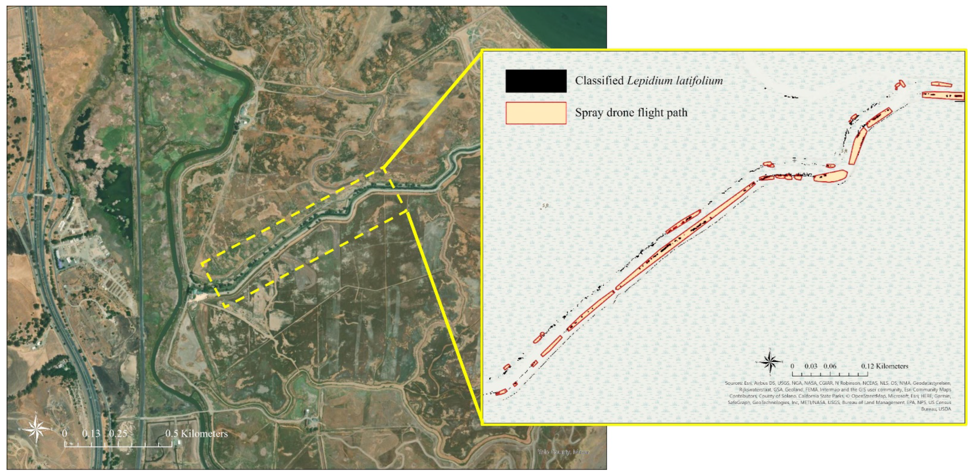
2.3. Invasive Species Detection

During the month of April 2020, we conducted remotely piloted survey drone imaging flights over eight wetland areas in the Suisun Marsh to detect Lepidium plants. The survey drone used was a DJI Phantom 3 Professional (DJI, Inc., Shenzhen, China) weighing 1280 g and equipped with a 1/2.3” CMOS Camera with 12.76 M pixels (4000 × 3000 single JPEG image pixel size) that collected true color (RGB) images. The camera lens was a FOV 94° 20 mm (35 mm format equivalent). The DJI gimbal had a 3-axis (pitch, roll, yaw) stabilization and Angular Control Accuracy of ±0.02°.
All flights were made at an altitude of 84 m, which produced ground images of approximately 5 × 5 cm pixel resolution. The survey drone had a maximum range of 0.5 km (0.3 miles) due to the controller-to-drone WiFi connection limit, and a survey drone with a charged battery operated for 15 min that covered approximately 12–15 ha. Gridded flight lines were generated with the Pix4Dmapper 4.5 application (Pix4D SA, Prilly, Switzerland) on an iPhone 12 (Apple, Inc., Cupertino, CA, USA) connected to a DJI controller unit. Geotagged photos of all Lepidium plants observed along roads and ditches were collected during the site visits on each drone flight day for use as control points to determine typical Lepidium plant coloration attributes in the pre-flowering stage.
All images captured during these drone flights were uploaded and processed with Pix4Dmapper. Automatic point cloud densification was used to produce a dense, 3D-point cloud and a true color orthophoto mosaic of all the images from a setting with 80% overlap. The point cloud was used as a basis for the generation of a digital surface model (DSM) and 3D mesh from each flight. This software automatically compensated for variations in brightness, luminosity, and color-balancing among images. Radiometric processing and calibration were applied to correct the image reflectance bands, taking illumination and sun angle into consideration.
Following the methods recommended by Andrew and Ustin’s [51,54] microtopography study for the most accurate detection of Lepidium plant coloration from aerial imaging, the difference index between the green and red reflectance bands (GRVI) of every flight image was next computed as GRVI = (G − R)/(G + R). The control point locations collected on flight days to match plant coloration for Lepidium were used to define the most probable range of GRVI values for this plant species within a range from −0.02 to −0.1. Classifications were trained using ground photos of Lepidium and generated in the ENVI® image processing and analysis software (Exelis Visual Information Solutions, Boulder, CO, USA).
To improve the accuracy of the classification and make microtopography adjustments, elevation from a 1 m resolution digital elevation map (DEM) of Suisun Marsh [55] was used to include any matching GRVI coloration pixels for the presence of Lepidium plants. Lepidium tends to grow on elevated areas, such as upland areas and levees; therefore, the absolute elevation threshold was initially set to >1 vertical meter for Lepidium patch inclusion (Figure 1). We then refined a customized relative elevation range for each marshland property for the probable presence of Lepidium patches based on rapid field surveys on the day following each drone flight.
Sites were selected based on our classification if they had a high concentration of Lepidium; in total, we chose eight wetland areas as host treatment sites (Figure 2). Those eight wetland areas were: Lower Joice Island (445 ha), Miramonte Gun Club (126 ha), Morrow Island (279 ha), Mallard Haven (41 ha), Grizzly Duck Club (74 ha), Gum Tree Farms (194 ha), Westwind Duck Club (216 ha), and Honker Farms (54 ha).

2.4. Herbicide Application

We used a PrecisionVision35© drone (Leading Edge Aerial Technologies Inc., Daytona Beach, FL, USA) to apply herbicide. The spray drone was designed to be adjustable, and users can set the swath width to apply herbicides between 3 and 20 m, treating from 0.2 to 0.8 ha/min (~14–17 ha/h) with a maximum tank capacity of 16.3 L [56]. The drone was powered by two batteries that can last ~14 min before being rotated with fully charged batteries.
We used a 76 L mix tank to supply the drone with herbicide to treat the Lepidium patches (~5 loads). To create our 76 L of herbicide mix, we first added 57 L of water, before turning on a circulation pump. Once the water was circulating, we added 300 mL of Telar® XP granules, 1.9 L of the surfactant Spreader 90®. and the remaining 17 L of water. We finished the mix by adding 0.6 L of dye. If the color of the mixture was not dark enough to be easily observed on the foliage, additional dye was added in 300 mL increments until the desired color was reached.
We conducted treatment of Lepidium in spring of 2020. All eight of our study sites were managed seasonal environments where water levels are controlled; in the spring and summer months, these areas are drained to support plant growth and habitat management. We treated Lepidium with a selective broad-leaf herbicide (Bayer Telar® XP), which is recommended for treating the surfaces of marshes, swamps, and bogs after the water has receded at a rate of 17–22 mL/ha [57]. Telar® XP is limited to use in wind speeds between 5 and 16 kmph and is applied to droplet sizes varying from coarse to very coarse. The active ingredient in Telar® XP is chlorsulfuron (75%), which is taken up by both the roots and foliage of plants [57]. The half-life of this chemical in the environment is 45 days and is not shown to have insecticidal properties [57]. While Telar® XP is toxic to fish and algae, it is not applied to aquatic environments in this study, as described in these methods. We applied Telar® XP over a 2-week period at or just prior to Lepidium flowering to maximize its effect [47]. In each of the eight wetland areas, transects were mapped with Precision Vision software (version 1.16.2) to obtain the most efficient coverage. The transects were sprayed with herbicide by the PrecisionVision35 carrying 11.3 L of chemical, surfactant, and dye was applied at a volume density of 47 L/ha (Video S1: Spray drone applying herbicide to control an invasive plant in a managed wetland). The drone flew at an altitude of 2–3 m and a speed of 24 kmph, and herbicide was applied with a swath width of 6 m (Figure 3). The drone was certified for the airspace authorization through a Certificate of Airworthiness (COA #2021-WSA-8451). Operators (TJE, WHR) were licensed to fly the drone by the Federal Aviation Administration (FAA) under Part 107 of the Aviation Code and by the California Department of Pesticide Regulations (DPR) as drone pilots.
The spray pattern was tested with spray cards and the DropVision AG software (Leading Edge Aerial Technologies Inc., Daytona Beach, FL, USA). We used 13 cards set at 1 m intervals from the centerline of the spray drone flight path (6 m in each direction from the centerline). During each spraying, we collected the number of droplets, the Volume Median Diameter (VMD), droplet density (cm2), and volume density (liter/hectare) on each spray card. VMD describes the droplet size at which 50% of the spray volume is larger, in droplets, than the VMD, and 50% are smaller [58]. This process was repeated five additional times, and the six repetitions were averaged to produce one number for each 1 m distance. For this test, the spray drone was flown at an altitude of 3 m in low-wind conditions (~5 kmph). After graphing the measurements, we calculated the area-under-the-curve of volume density to determine the percent of herbicide distributed within the core swath of the drone (4 m to either side of the center).

2.5. Treatment Efficacy

Within 3–4 weeks of treatment, to ensure that chemical effects could be observed, we randomly selected accessible treatment transects in each area to measure chemical treatment efficacy. Field biologists used a survey tape and 1 m2 quadrats to assess results. A 25 m survey tape was laid out along survey lines within a selected treatment transect along the direction of travel. The quadrat was laid down every 2.5 m to obtain a uniform distribution of samples in the treatment area. For each of the eight treatment areas, we sampled from a minimum of 30 quadrats to a maximum of 100, sampling 10 quadrats along each of 3–10 survey lines. Field biologists noted: (1) if the area appeared to be sprayed; (2) if there was evidence of the effect of herbicide (senescence or browning); (3) the percent of each quadrat covered by Lepidium; (4) the percent of the Lepidium within the quadrat that was affected. The data were recorded on field data forms, entered into Excel, and analyzed for treatment effectiveness (Figure 4). We considered the percentage of Lepidium affected by the total amount of Lepidium within each quadrat to be our metric for treatment effectiveness. To supplement our efficacy measurements on the ground, we also visually examined the pre- and post-treatment images taken by our survey drone.

3. Results

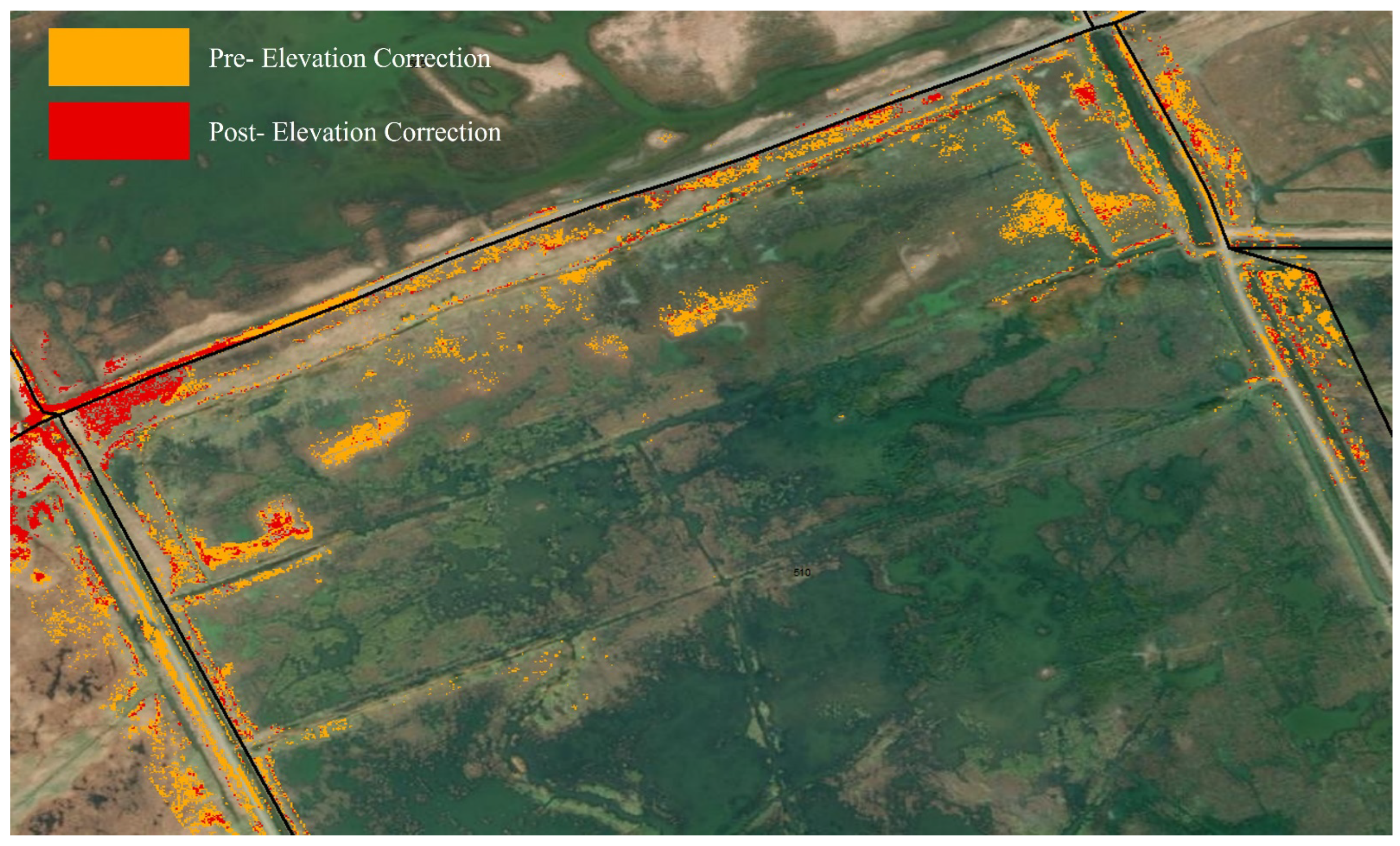
3.1. Mapping Extent Analysis

We classified a total of 4.98 ha of Lepidium across our eight study sites (Table 1, Figure 5). The Westwind site yielded the largest area of Lepidium (2.99 ha), and the Westwind/Gum Tree site yielded the smallest (0.09 ha; Table 1).

3.2. Area Treated

Across the eight treatment sites, patches within a total of 14.1 ha were sprayed using the spray drone (Table 1; Figure 1). Morrow Island received the most treatment along the Morrow Island Distribution System run by the California Department of Water Resources (Figure 5: 3.4 ha), while Gum Tree Farms received the least (0.8 ha). On average, 1.8 ha of Lepidium was treated with herbicide at each site.

3.3. Spray Drone Efficacy Analysis

Across all eight sites, 589 1 m quadrats were sampled in the field. Of those 589 quadrats 12 (2%) were found to have no Lepidium present and therefore removed from efficacy calculations, leaving 577 quadrats in the analysis (Table 2). Ninety-seven percent (562) of the quadrats contained Lepidium that displayed effects (browning, senescence) from the herbicide treatment. Overall, the 577 quadrats with Lepidium had a mean of 38% of the quadrat covered by the plant (219 m2; Table 2).
Our spray drone treatment was most effective on the Westwind/Gum Tree site (99% efficacy; Table 2), and least effective on Mallard Haven (29%). Overall, our spray drone was 87% effective at treating Lepidium within our quadrats (Table 2).

3.4. Assessment of Drift

The number of droplets was the highest within 2 m of the spray drone’s flight path (Figure 6). Volume density was the highest 1 m and 2 m from the spray drone’s flight path and lowest at the spray card farthest from the centerline (6 m; 1.84 drops/cm2). We estimated that 75% of the herbicide fell within 4 m, and 90% within 5 m, of either side of the centerline (Figure 6).

4. Discussion

Our spray drone was very effective in treating invasive patches of Lepidium (Figure 6). On average, 87% of Lepidium treated with herbicide by our spray drone displayed browning, senescence, or other clear effects, with some sites yielding an efficacy of close to 100%. Relative to other treatment options, such as helicopter-spraying, ground application, or application from an all-terrain vehicle or tractor, these results are comparable or better [59,60,61]. Helicopter-spraying has been shown to contribute to the mortality of 70% of targeted Tamarix spp. in Colorado [60], while research in an Australian saltmarsh reduced Spartina anglica densities by almost 100% six months after treatment [61]. Smaller-scale applications, such as backpack- or tractor-spraying, have reduced the densities of other targeted invasive plant species by 75–85% [59,62].
The efficacy of our treatment was over 80% at all sites except one—Mallard Haven—which yielded only 29% effectiveness for Lepidium. It is unclear why this site had a lower efficacy rate than all other sites; while higher winds have been shown to decrease herbicide effectiveness [63], wind levels the day of treatment on Mallard Haven were similar to those on Miramonte Gun Club and Grizzly/Gum Tree (Table 1). Only 18% of the quadrats on this site were covered with Lepidium; it is possible that the sparse distribution of the plants reduced the effectiveness. The large droplet size produced by the spray drone, while reducing drift potential, may also lead to a lower herbicide retention on wet leaves [64]. In addition, wet vegetation may result in lower efficacy, but there is no indication that the environmental conditions were different and that the vegetation was wetter at Mallard Haven.
The risk of overspray or herbicide drift is a primary concern for ecosystem managers when treating plant invasions. Unintended exposure to herbicides or similar chemicals has been shown to have detrimental effects on both surrounding plants and wildlife [22,65]. Marrs et al. [65] suggested that plants within 2–6 m of the spray zone could be lethally affected by herbicide treatment, and that a buffer of 5–10 m was necessary for ground-sprayers to protect non-target vegetation. Drift has been shown to have negative effects on arthropod communities [65], as well as potentially detrimental effects to aquatic and terrestrial wildlife [24]. Given that Lepidium forms dense monocultures [13], containing herbicide to the plants of interest will be crucial to maximizing its effectiveness.
Our spray card tests showed that the number of droplets, droplet density, and estimated volume density was substantially lower as little as 6 m from the center of the drone’s flight path. Less than a quarter of droplet deposition was applied outside of 4 m and 10% outside of 5 m from the centerline of the drone’s flight path, showing that the majority of the chemical was contained to the core swath. Herbicide that is sprayed with a coarse droplet size (>300 VMD) has been shown to substantially reduce herbicide drift [66,67]. The American Society of Agricultural and Biological Engineers (ASABE) classified ultra-coarse droplets (>665 VMD) as having a low drift potential [64], and our spray drone consistently yielded large droplets (>1000 VMD) even at the edges of its swath, indicating that the potential for herbicide drift was reduced. In comparison, other forms of aerial application, such as helicopter-spraying, may require a 30–50 m buffer to reduce drift effects [68], while spray drones administering herbicide with small droplet sizes (<160 VMD) may require a minimum 10 m buffer [67].
Because of the much lower 2–3 m flight altitude, small rotor-wash, and large droplet sizes, herbicide administered by our spray drone may be less susceptible to drift on windier days and provide more forgiveness in unpredictable weather [40,69,70]. For example, maximum wind speeds above 16 kmph (the maximum recommended wind speed for which Telar® XP should be applied) occurred on an average of 14 days (±3; 17%) in Suisun Marsh from March through May 2017–2019 [71]. Ground effects may reduce windspeeds near the wetland surface (2–3 m AGL (above ground level)) allowing for spray drone treatment flights to be implemented when upper atmospheric wind conditions preclude the use of manned aircraft flying at higher elevations AGL. An herbicide application that can work more efficiently with minimal risk of drift is an important advantage in windy ecosystems. Furthermore, because the spray drone can be loaded with pre-programmed flight transects that overfly defined patches, the risk of human error during manual flights is minimized, and only specific areas of interest can be treated, since the nozzles may be programmed to turn on and off. However, there currently are no specific label directions for herbicides that explicitly consider spray-drone applications.
Conversely, the presence of drones has been shown to have behavior effects on some wildlife [72,73,74,75,76,77,78]. Drones may have a particularly noticeable effect on birds [73,76]. In Australia, researchers observed some aggressive behavior from solitary breeding birds towards drones, including a raptor that attacked a fixed-wing drone [74]. Similarly, Bech-Hansen et al. [76] showed that geese were increasingly disturbed and flushed by drones approaching within 300 m. Terrestrial mammals may be less affected than birds but have nonetheless been shown to exhibit increased stress in the presence of a drone [73,78,79,80]. We did not observe any negative effects of our drones on the surrounding wildlife, including large birds, during this study, and the birds we observed during treatment flights seemed to ignore the spray drone, perhaps because our flights were conducted at a low altitude over a short timespan. However, the potential for adverse interactions depends on the specific ecosystem and species in question [73,77]. Future spray-drone treatments should continue to document and minimize the potential for adverse impacts on local fauna.
In addition to effectively treating invasive plants, our spray drone may provide a more cost-effective option compared to other herbicide applicators. As with all herbicide applicators (backpack, tractor, helicopter, etc.), invasive plant management with a spray drone requires investing in up-front expenses. These include covering the cost of acquiring the unit, batteries, drone software license, smartphone or tablet with an aerial application, appropriate herbicide, and chemical mixing supplies. However, once the initial investment is made, operational costs to treat patches of invasive plants may be lower with the spray drone. In Suisun Marsh, the hand application of herbicide with a team of backpack sprayers commercially costs USD 456.95/ha (author’s unpublished data). Tractor spraying in Suisun Marsh has been estimated to cost USD 97.50/ha (D. May, pers. comm.), while the helicopter-spraying provided by (AgAir, Inc., pers. comm.) costs up to USD 140.45/ha sprayed. During this study, we only incurred the operational costs of trained technicians to pilot the spray drone, mix the chemical, and manage the logistics of its operation. Assuming a conservative 1 ha/h rate of spray application, operational costs are primarily related to the technician time, here estimated at USD 36.79/ha (author’s unpubl. data).
The commercial rate for spray drone application with the equipment and pilot provided is estimated at USD 125–150/ha (Leading Edge Aerial Technologies, Inc.) with added travel costs, but it is a substantially cheaper option than contracting backpack-spraying and comparable to contracting a conventional helicopter applicator. While wide variations in terrain, weather conditions, and labor costs makes it difficult to accurately compare commercial treatment methods, the spray drone is likely a viable intermediate-cost option for those interested in spraying smaller patches (5–15 ha per day) of invasive plants in a short amount of time. The ability to control smaller patches of invasive plants, as can be achieved with a spray drone, is a core principle of early-detection rapid-response (EDRR) invasive vegetation management [53]. In addition, the initial expenses of acquiring a spray drone should further decrease with the wider adoption of the treatment method.
We encountered challenges in classifying and mapping Lepidium with imagery from the survey drone, primarily because the plant needed to be detected early in its annual growth period to treat it before it senesced. Previous work has identified defining spectral characteristics of Lepidium [54]; however, these characteristics vary greatly depending on the time of year and life stage of the plant. Lepidium has bright white flowers that bloom in the dry season and are a valuable visual identifier of the species [50,54]. However, if the flowers are not present or similarly colored plants are present (such as wild radish, Raphanus savitus), identifying Lepidium may prove more difficult using color imagery. Our original classification yielded a map of potential Lepidium that included vast swaths of the marsh and greatly overestimated the species’ extent. After including elevation into our classification [54], we were able to substantially reduce the distribution and produce a more accurate identification map. The distribution of other wetland-invasive plant species has been more extensively modeled; for example, Phragmites australis in the Suisun Marsh was classified using publicly available aerial imagery with over 90% accuracy [81].
Spray drones or UAS have been employed extensively to apply herbicide in agricultural systems for years, especially in Asia [37,42]. Additionally, spray drones have been used to manage mosquito and crop pest infestations in these systems with success [33,34,35,36]. However, spray drones have yet to emerge as a widespread option for invasive plant management in the restoration and ecological fields. Our results suggest that spray drones will be effective in combating invasive Lepidium in tidal wetlands, but more research is needed to identify their value for other species and ecosystems. Similarly, programming a spray drone to identify invasive plants and apply herbicide in a single flight is a goal to drastically reduce the cost of treatment and duration of flight time [82,83]
While our study employed a survey drone and a spray drone in separate missions, merging the functions of the two in the spray drone with a similar camera system to the survey drone could greatly improve efficiency. Managers could rapidly identify and administer herbicide to a selected invasive species during a single flight while reducing human error and risk of wildlife disturbance. This efficiency will be especially valuable in targeting small, emergent patches of invasive vegetation to support early detection and rapid response [52,53]. However, implementation of the spray drone will require consideration of, and commitment to, long-term, adaptive management. While much of the invasive species management is successful in the short-term, long-term success is often more elusive and requires continuous monitoring [44,61,84]. Given that economics are often a primary consideration when determining how to best manage plant invasions, finding a means of making spray-drone treatments more cost-effective should be a priority to support long-term management. There are several vendors in North America that currently use commercially available spray drones, such as DJI Agriculture (Shenzhen, Guangdong, China) and Empire Drone (Syracuse, NY, USA), in agriculture and vector control. As the industry continues to innovate, precision spray drones should become even more accessible and useful for a wide range of applications in natural resource management.

Supplementary Materials

The following supporting information can be downloaded at: https://www.mdpi.com/article/10.3390/rs15153845/s1, Video S1: Spray drone applying herbicide to control an invasive plant in a managed wetland.

Author Contributions

Conceptualization, J.Y.T., T.J.E., J.M.C., S.C.C. and W.H.R.; methodology, J.Y.T., J.S.H. and W.H.R.; software, W.H.R.; data curation, J.S.H. and J.M.C.; writing—original draft preparation, J.Y.T. and J.S.H.; writing—review and editing, T.J.E., J.M.C., S.C.C. and W.H.R.; funding acquisition, J.Y.T. and S.C.C. All authors have read and agreed to the published version of the manuscript.

Funding

This research was partially funded by California Department of Food and Agriculture, grant number 18-0652-000-SG.

Data Availability Statement

Data used in to calculate Lepidium efficacy and those measured in our spray-card droplet tests can be found on Google Drive at: https://drive.google.com/drive/folders/1pVbgMfDfGwU3v4jZNNSn_45c9t30lesI?usp=sharing (accessed on 21 March 2023).

Acknowledgments

Support for the fieldwork was provided by the Suisun Resource Conservation District and the California Department of Water Resources (C. Feldheim). We thank the biologists who were involved in the fieldwork and the landowners (K. Peacock, G. Daniel, R. Tesene, L. Gianno, Gumtree, C. Taylor, K. Puccini), who provided access for the study and remote sensing analysis advice (C. Potter, CASA2100).

Conflicts of Interest

WHR is the President of Leading Edge Aerial Technologies (Daytona Beach, FL, USA), which manufactured the spray drone used in this demonstration project. However, the spray drone was purchased independently, and the study was not sponsored by LEAT. The authors declare no other conflicts of interest.

References

  1. Vitousek, P.M.; D’Antonio, C.; Loope, L.L.; Rejmánek, M.; Westbrooks, R. Introduced Species: A significant component of human-caused global change. N. Z. J. Ecol. 1997, 21, 1–16. [Google Scholar]
  2. Houlahan, J.E.; Findlay, C.S. Effect of Invasive Plant Species on Temperate Wetland Plant Diversity. Conserv. Biol. 2004, 18, 1132–1138. [Google Scholar] [CrossRef]
  3. Vila, M.; Weiner, J. Are Invasive Plant Species Better Competitors than Native Plant Species? Evidence from Pair-Wise Experiments. Oikos 2004, 105, 229–238. [Google Scholar] [CrossRef]
  4. Zedler, J.B.; Kercher, S. Causes and Consequences of Invasive Plants in Wetlands: Opportunities, Opportunists, and Outcomes. Crit. Rev. Plant Sci. 2004, 23, 431–452. [Google Scholar] [CrossRef]
  5. Van Kleunen, M.; Weber, E.; Fischer, M. A Meta-Analysis of Trait Differences between Invasive and Non-Invasive Plant Species. Ecol. Lett. 2010, 13, 235–245. [Google Scholar] [CrossRef] [Green Version]
  6. Pritekel, C.; Whittemore-Olson, A.; Snow, N.; Moore, J.C. Impacts from Invasive Plant Species and Their Control on the Plant Community and Belowground Ecosystem at Rocky Mountain National Park, USA. Appl. Soil Ecol. 2006, 32, 132–141. [Google Scholar] [CrossRef]
  7. Davidson, N.C. How Much Wetland Has the World Lost? Long-Term and Recent Trends in Global Wetland Area. Mar. Freshw. Res. 2014, 65, 934–941. [Google Scholar] [CrossRef] [Green Version]
  8. Smith, K.R.; Barthman-Thompson, L.M.; Estrella, S.K.; Riley, M.K.; Trombley, S.N.; Rose, C.A.; Kelt, D.A.; Carraway, L. Demography of the Salt Marsh Harvest Mouse (Reithrodontomys raviventris halicoetes) and Associated Rodents in Tidal and Managed Wetlands. J. Mammal. 2020, 101, 129–142. [Google Scholar] [CrossRef]
  9. Chen, L. Invasive Plants in Coastal Wetlands: Patterns and Mechanisms. In Wetlands: Ecosystem Services, Restoration and Wise Use; Springer: Berlin/Heidelberg, Germany, 2019; Volume 238, pp. 97–128. [Google Scholar]
  10. Moyle, P.B.; Manfree, A.D.; Fiedler, P.L. Suisun Marsh: Ecological History and Possible Futures; University of California Press: Berkeley, CA, USA; Los Angeles, CA, USA, 2014; ISBN 978-0-520-95732-9. [Google Scholar]
  11. Agha, M.; Yackulic, C.B.; Riley, M.K.; Peterson, B.; Todd, B.D. Brackish Tidal Marsh Management and the Ecology of a Declining Freshwater Turtle. Environ. Manag. 2020, 66, 644–653. [Google Scholar] [CrossRef]
  12. Casazza, M.L.; McDuie, F.; Jones, S.; Lorenz, A.A.; Overton, C.T.; Yee, J.; Feldheim, C.L.; Ackerman, J.T.; Thorne, K.M. Waterfowl Use of Wetland Habitats Informs Wetland Restoration Designs for Multi-Species Benefits. J. Appl. Ecol. 2021, 58, 1910–1920. [Google Scholar] [CrossRef]
  13. Leininger, S.P.; Foin, T.C. Lepidium latifolium Reproductive Potential and Seed Dispersal along Salinity and Moisture Gradients. Biol. Invasions 2009, 11, 2351–2365. [Google Scholar] [CrossRef] [Green Version]
  14. Wigginton, R.D.; Kelso, M.A.; Grosholz, E.D. Time-Lagged Impacts of Extreme, Multi-Year Drought on Tidal Salt Marsh Plant Invasion. Ecosphere 2020, 11, e03155. [Google Scholar] [CrossRef]
  15. Reynolds, L.K.; Boyer, K.E. Perennial Pepperweed (Lepidium latifolium): Properties of Invaded Tidal Marshes. Invasive Plant Sci. Manag. 2010, 3, 130–138. [Google Scholar] [CrossRef]
  16. Blank, R.R. Amidohydrolase Activity, Soil N Status, and the Invasive Crucifer Lepidium latifolium. Plant Soil 2002, 239, 155–163. [Google Scholar] [CrossRef]
  17. Spautz, H.; Nur, N. Impacts of Non-Native Perennial Pepperweed (Lepidium latifolium) on Abundance, Distribution and Reproductive Success of San Francisco Bay Tidal Marsh Birds. PRBO Conserv. Sci. 2004, 1–90. [Google Scholar]
  18. Boyer, K.E.; Burdick, A.P. Control of Lepidium latifolium (Perennial Pepperweed) and Recovery of Native Plants in Tidal Marshes of the San Francisco Estuary. Wetl. Ecol. Manag. 2010, 18, 731–743. [Google Scholar] [CrossRef]
  19. Whitcraft, C.R.; Grewell, B.J. Evaluation of Perennial Pepperweed (Lepidium latifolium) Management in a Seasonal Wetland in the San Francisco Estuary Prior to Restoration of Tidal Hydrology. Wetl. Ecol. Manag. 2012, 20, 35–45. [Google Scholar] [CrossRef]
  20. Grewell, B.J.; Baye, P.R.; Fiedler, P.L. Shifting Mosaics: Vegetation of Suisun Marsh. In Suisun Marsh: Ecological History and Possible Futures; University of California Press: Berkeley, CA, USA, 2014; pp. 65–101. ISBN 978-0-520-95732-9. [Google Scholar]
  21. Kerr, D.W.; Hogle, I.B.; Ort, B.S.; Thornton, W.J. A Review of 15 Years of Spartina Management in the San Francisco Estuary. Biol. Invasions 2016, 18, 2247–2266. [Google Scholar] [CrossRef]
  22. Marrs, R.H.; Williams, C.T.; Frost, A.J.; Plant, R.A. Assessment of the Effects of Herbicide Spray Drift on a Range of Plant Species of Conservation Interest. Environ. Pollut. 1989, 59, 71–86. [Google Scholar] [CrossRef]
  23. Pimentel, D.; Lach, L.; Zuniga, R.; Morrison, D. Environmental and Economic Costs of Nonindigenous Species in the United States. BioScience 2000, 50, 53–65. [Google Scholar] [CrossRef] [Green Version]
  24. Burn, A. Pesticide Buffer Zones for the Protection of Wildlife. Pest Manag. Sci. 2003, 59, 583–590. [Google Scholar] [CrossRef]
  25. Boutin, C. Herbicides: Non-Target Species Effects. In Encyclopedia of Environmental Management; CRC Press: Boca Raton, FL, USA, 2015; pp. 33–48. [Google Scholar]
  26. Shahbazi, M.; Théau, J.; Ménard, P. Recent Applications of Unmanned Aerial Imagery in Natural Resource Management. GIScience Remote Sens. 2014, 51, 339–365. [Google Scholar] [CrossRef]
  27. Johnson, R.; Smith, K.; Wescott, K. Unmanned Aircraft System (UAS) Applications to Land and Natural Resource Management. Environ. Pract. 2015, 17, 170–177. [Google Scholar] [CrossRef] [Green Version]
  28. Madden, M.; Jordan, T.; Cotten, D.; O’Hare, N.; Pasqua, A.; Bernardes, S. The Future of Unmanned Aerial Systems for Monitoring Natural and Cultural Resources. Photogramm. Week 2015, 15, 369–385. [Google Scholar]
  29. Louargant, M.; Villette, S.; Jones, G.; Vigneau, N.; Paoli, J.N.; Gée, C. Weed Detection by UAV: Simulation of the Impact of Spectral Mixing in Multispectral Images. Precis. Agric. 2017, 18, 932–951. [Google Scholar] [CrossRef]
  30. Jeziorska, J. UAS for Wetland Mapping and Hydrological Modeling. Remote Sens. 2019, 11, 1997. [Google Scholar] [CrossRef] [Green Version]
  31. Gallego, D.; Sarasola, J.H. Using Drones to Reduce Human Disturbance While Monitoring Breeding Status of an Endangered Raptor. Remote Sens. Ecol. Conserv. 2021, 7, 550–561. [Google Scholar] [CrossRef]
  32. Robinson, J.M.; Harrison, P.A.; Mavoa, S.; Breed, M.F. Existing and emerging uses of drones in restoration ecology. Methods Ecol. Evol. 2022, 13, 1899–1911. [Google Scholar] [CrossRef]
  33. Yallapa, D.; Veerangouda, M.; Maski, D.; Palled, V.; Bheemanna, M. Development and evaluation of drone mounted sprayer for pesticide applications to crops. In Proceedings of the GHTC 2017—IEEE Global Humanitarian Technology Conference, San Jose, CA, USA, 19–22 October 2017; pp. 1–7. [Google Scholar] [CrossRef]
  34. Carrasco-Escobar, G.; Moreno, M.; Fornace, K.; Herrera-Varela, M.; Manrique, E.; Conn, J.E. The use of drones for mosquito surveillance and control. Parasites Vectors 2022, 15, 473. [Google Scholar] [CrossRef] [PubMed]
  35. Mogili, U.M.R.; Deepak, B.B.V.L. Review on application of drone systems in precision agriculture. Procedia Comput. Sci. 2018, 133, 502–509. [Google Scholar] [CrossRef]
  36. Li, X.; Giles, D.K.; Niederholzer, F.J.; Andaloro, J.T.; Lang, E.B.; Watson, L.J. Evaluation of an unmanned aerial vehicle as a new method of pesticide application for almond crop protection. Pest Manag. Sci. 2020, 77, 527–537. [Google Scholar] [CrossRef] [PubMed]
  37. Xionghui, H.; Bonds, J.; Herbst, A.; Langenakens, J. Recent development of unmanned aerial vehicle for plant protection in East Asia. Int. J. Agric. Biol. Eng. 2017, 10, 18–30. [Google Scholar]
  38. Ahmad Suhaizi, M.; Azmi, Y.; Norida, M.; Mohamad Saiful, A. Evaluation of the Spraying Dispersion and Uniformity Using Drone in Rice Field Application. In Proceedings of the 2018 MSAE Conference, Serdang, Malaysia, 7–8 February 2018; pp. 967–978. [Google Scholar]
  39. Wang, G.; Lan, Y.; Yuan, H.; Qi, H.; Chen, P.; Ouyang, F.; Han, Y. Comparison of Spray Deposition, Control Efficacy on Wheat Aphids and Working Efficiency in the Wheat Field of the Unmanned Aerial Vehicle with Boom Sprayer and Two Conventional Knapsack Sprayers. Appl. Sci. 2019, 9, 218. [Google Scholar] [CrossRef] [Green Version]
  40. Martin, D.; Singh, V.; Latheef, M.A.; Bagavathiannan, M. Spray deposition on weeds (Palmer Amarath and Morningglory) from a remotely piloted aerial application system and backpack sprayer. Drones 2020, 4, 59. [Google Scholar] [CrossRef]
  41. Roslim, M.H.M.; Juraimi, A.S.; Che’ya, N.N.; Sulaiman, N.; Manaf, M.N.H.A.; Ramli, Z.; Motmainna, M. Using Remote Sensing and an Unmanned Aerial System for Weed Management in Agricultural Crops: A Review. Agronomy 2021, 11, 1809. [Google Scholar] [CrossRef]
  42. Wang, L.; Huang, X.; Li, W.; Yan, K.; Han, Y.; Zhang, Y.; Pawlowski, L.; Lan, Y. Progress in agricultural unmanned aerial vehicles (UAVs) applied in China and prospects for Poland. Agriculture 2022, 12, 397. [Google Scholar] [CrossRef]
  43. Eng, M.J.A.; Sehsah, E.M.E. Farm Machinery and Power Study on Helicopter Aerial Spraying Under Field Canola Conditions. Misr J. Agric. Eng. 2012, 29, 893–910. [Google Scholar] [CrossRef]
  44. Kettenring, K.M.; Adams, C.R. Lessons Learned from Invasive Plant Control Experiments: A Systematic Review and Meta-Analysis. J. Appl. Ecol. 2011, 48, 970–979. [Google Scholar] [CrossRef] [Green Version]
  45. Andrew, M.E.; Ustin, S.L. Spectral and physiological uniqueness of perennial pepperweed (Lepidium latifolium). Weed Sci. 2006, 54, 1051–1062. [Google Scholar] [CrossRef]
  46. Vanderhoof, M.; Holzman, B.A.; Rogers, C. Predicting the distribution of perennial pepperweed (Lepidium latifolium), San Francisco Bay area, California. Invasive Plant Sci. Manag. 2009, 2, 260–269. [Google Scholar] [CrossRef]
  47. Young, J.A.; Palmquist, D.E.; Blank, R.S.; Turner, C.E. Ecology and Control of Perennial Pepperweed (Lepidium latifolium L.). In Proceedings of the California Exotic Pest Plant Council Symposium ’95, Pacific Grove, CA, USA, 6–8 October 1995. [Google Scholar]
  48. Young, J.; Palmquist, D.; Blank, R. The Ecology and Control of Perennial Pepperweed (Lepidium latifolium L.). Weed Technol. 1998, 12, 402–405. [Google Scholar] [CrossRef] [Green Version]
  49. Renz, M.; DiTomaso, J. Early season mowing improves the effectiveness of Chlorsulfuron and Glyphosate for control of perennial pepperweed (Lepidium latifolium). Weed Technol. 2006, 20, 32–36. [Google Scholar] [CrossRef]
  50. Young, J.A.; Turner, C.E.; James, L.F. Perennial Pepperweed. Rangelands 1995, 17, 121–123. [Google Scholar]
  51. Andrew, M.E.; Ustin, S.L. Habitat suitability modeling of an invasive plant with advanced remote sensing data. Divers. Distrib. 2009, 15, 627–640. [Google Scholar] [CrossRef]
  52. Martinez, B.; Reaser, J.K.; Dehgan, A.; Zamft, B.; Baisch, D.; McCormick, C.; Giordano, A.J.; Aicher, R.; Selbe, S. Technology innovation: Advancing capacities for the early detection of and rapid response to invasive species. Biol. Invasions 2020, 22, 75–100. [Google Scholar] [CrossRef] [Green Version]
  53. Reaser, J.K.; Burgiel, S.W.; Kirkey, J.; Brantley, K.A.; Veatch, S.D.; Burgos-Rodriguez, J. The early detection of and rapid response (EDRR) to invasive species: A conceptual framework and federal capacities assessment. Biol. Invasions 2020, 22, 1–19. [Google Scholar] [CrossRef] [Green Version]
  54. Andrew, M.E.; Ustin, S.L. Effects of Microtopography and Hydrology on Phenology of an Invasive Herb. Ecography 2009, 32, 860–870. [Google Scholar] [CrossRef]
  55. Buffington, K.J.; Thorne, K.M.; Takekawa, J.Y.; Chappell, S.; Swift, T.; Feldheim, C.; Squellati, A.; Mardock, D.K. LEAN-Corrected DEM for Suisun Marsh: U.S. Geological Survey Data Release; U.S. Geological Survey: Washington, DC, USA, 2019. [CrossRef]
  56. Leading Edge Aerial Technologies. PrecisionVision 35 UAS Brochure V.2; Leading Edge Aerial Technologies: Daytona, Fl, USA, 2019. [Google Scholar]
  57. DuPont. DuPontTM Telar® XP Herbicide. Available online: www.dupont.com (accessed on 21 March 2023).
  58. Matthews, G.A. Pesticides Application Methods, 2nd ed.; Longman Scientific and Technical Publications: London, UK, 1992; 405p. [Google Scholar]
  59. Carlson, A.M.; Gorchov, D.L. Effects of Herbicide on the Invasive Biennial Alliaria Petiolata (Garlic Mustard) and Initial Responses of Native Plants in a Southwestern Ohio Forest. Restor. Ecol. 2004, 12, 559–567. [Google Scholar] [CrossRef]
  60. Douglass, C.H.; Nissen, S.J.; Kniss, A.R. Efficacy and Environmental Fate of Imazapyr from Directed Helicopter Applications Targeting Tamarix Species Infestations in Colorado. Pest Manag. Sci. 2016, 72, 379–387. [Google Scholar] [CrossRef]
  61. Shimeta, J.; Saint, L.; Verspaandonk, E.R.; Nugegoda, D.; Howe, S. Long-Term Ecological Consequences of Herbicide Treatment to Control the Invasive Grass, Spartina Anglica, in an Australian Saltmarsh. Estuar. Coast. Shelf Sci. 2016, 176, 58–66. [Google Scholar] [CrossRef]
  62. Bakacsy, L.; Bagi, I. Survival and Regeneration Ability of Clonal Common Milkweed (Asclepias syriaca L.) after a Single Herbicide Treatment in Natural Open Sand Grasslands. Sci. Rep. 2020, 10, 14222. [Google Scholar] [CrossRef] [PubMed]
  63. Kudsk, P.; Kristensen, J. Effect of Environmental Factors on Herbicide Performance. In Proceedings of the First International Weed Control Congress, Melbourne, Australia, 17–21 February 1992; pp. 173–186. [Google Scholar]
  64. American Society of Agricultural and Biological Engineers (ASABE). Spray Nozzle Classification by Droplet Spectra. 2020. Available online: www.mssoy.org (accessed on 14 March 2023).
  65. Egan, J.F.; Bohnenblust, E.; Goslee, S.; Mortensen, D.; Tooker, J. Herbicide Drift Can Affect Plant and Arthropod Communities. Agric. Ecosyst. Environ. 2014, 185, 77–87. [Google Scholar] [CrossRef]
  66. Ramsdale, B.K.; Messersmith, C.G. Drift-Reducing Nozzle Effects on Herbicide Performance 1. Weed Technol. 2001, 15, 453–460. [Google Scholar] [CrossRef]
  67. Chen, S.; Lan, Y.; Zhou, Z.; Ouyang, F.; Wang, G.; Huang, X.; Deng, X.; Cheng, S. Effect of droplet size parameters on droplet deposition and drift of aerial spraying by using plant protection UAV. Agronomy 2020, 10, 195. [Google Scholar] [CrossRef] [Green Version]
  68. Robinson, R.C.; Parsons, R.G.; Barbe, G.; Patel, P.T.; Murphy, S. Drift Control and Buffer Zones for Helicopter Spraying of Bracken (Pteridium Aquilinum). Agric. Ecosyst. Environ. 2000, 79, 215–231. [Google Scholar] [CrossRef]
  69. Grant, S.; Perine, J.; Abi-Akar, F.; Lane, T.; Kent, B.; Mohler, C.; Scott, C.; Ritter, A. A wind-tunnel assessment of parameters that may impact spray drift during UAV pesticide application. Drones 2022, 6, 204. [Google Scholar] [CrossRef]
  70. Zhan, Y.; Chen, P.; Xu, W.; Chen, S.; Han, Y.; Lan, Y.; Wang, G. Influence of the downwash airflow distribution characteristics of a plant protection UAV on spray deposit distribution. Biosyst. Eng. 2022, 216, 32–45. [Google Scholar] [CrossRef]
  71. National Oceanic and Atmospheric Association (NOAA). Global Surface Summary of the Day—San Francisco Bay Reserve, CA, USA. Available online: https://www.ncei.noaa.gov/access/search/data-search/global-summary-of-the-day (accessed on 20 March 2023).
  72. Vas, E.; Lescroël, A.; Duriez, O.; Boguszewski, G.; Grémillet, D. Approaching Birds with Drones: First Experiments and Ethical Guidelines. Biol. Lett. 2015, 11, 20140754. [Google Scholar] [CrossRef] [Green Version]
  73. Mulero-Pázmány, M.; Jenni-Eiermann, S.; Strebel, N.; Sattler, T.; Negro, J.J.; Tablado, Z. Unmanned Aircraft Systems as a New Source of Disturbance for Wildlife: A Systematic Review. PLoS ONE 2017, 12, e0178448. [Google Scholar] [CrossRef] [Green Version]
  74. Lyons, M.; Brandis, K.; Callaghan, C.; McCann, J.; Mills, C.; Ryall, S.; Kingsford, R. Bird Interactions with Drones, from Individuals to Large Colonies. Aust. Field Ornithol. 2017, 35, 51–56. [Google Scholar] [CrossRef] [Green Version]
  75. Barnas, A.; Chabot, D.; Hodgson, A.J.; Johnston, D.W.; Bird, D.M.; Ellis-Felege, S.N. A standardized protocol for reporting methods when using drones for wildlife research. J. Unmanned Veh. Syst. 2020, 8, 89–98. [Google Scholar] [CrossRef] [Green Version]
  76. Bech-Hansen, M.; Kallehauge, R.M.; Lauritzen, J.M.S.; Sørensen, M.H.; Laubek, B.; Jensen, L.F.; Pertoldi, C.; Bruhn, D. Evaluation of Disturbance Effect on Geese Caused by an Approaching Unmanned Aerial Vehicle. Bird Conserv. Int. 2020, 30, 169–175. [Google Scholar] [CrossRef]
  77. Mo, M.; Bonatakis, K. An examination of trends in the growing scientific literature on approaching wildlife with drones. Drone Syst. Appl. 2022, 10, 111–139. [Google Scholar] [CrossRef]
  78. Schad, L.; Fischer, J. Opportunities and risks in the use of drones for studying animal behavior. Methods Ecol. Evol. 2022, 1–9. [Google Scholar] [CrossRef]
  79. Ditmer, M.A.; Vincent, J.B.; Werden, L.K.; Tanner, J.C.; Laske, T.G.; Iaizzo, P.A.; Garshelis, D.L.; Fieberg, J.R. Bears Show a Physiological but Limited Behavioral Response to Unmanned Aerial Vehicles. Curr. Biol. 2015, 25, 2278–2283. [Google Scholar] [CrossRef] [Green Version]
  80. Brunton, E.; Bolin, J.; Leon, J.; Burnett, S. Fright or Flight? Behavioural Responses of Kangaroos to Drone-Based Monitoring. Drones 2019, 3, 41. [Google Scholar] [CrossRef] [Green Version]
  81. Hagani, J.S.; Takekawa, J.T.; Chappell, S.C.; Richelle, L.T.; Ernst, A.R.; Kettenring, K.M. A remote sensing approach to assess the historical invasion of Phragmites australis in a brackish coastal marsh. Front. Ecol. Evol. 2023, 11, 1171245. [Google Scholar] [CrossRef]
  82. Huang, Y.; Reddy, K.N.; Fletcher, R.S.; Pennington, D. UAV low-altitude remote sensing for precision weed management. Weed Technol. 2017, 32, 2–6. [Google Scholar] [CrossRef]
  83. Khan, S.; Tufail, M.; Khan, M.T.; Khan, Z.A.; Anwar, S. Deep learning-based identification system of weeds and crops in strawberry and pea fields for a precision agriculture sprayer. Precis. Agric. 2021, 22, 1711–1727. [Google Scholar] [CrossRef]
  84. Blossey, B. Before, during and after: The Need for Long-Term Monitoring in Invasive Plant Species Management. Biol. Invasions 1999, 1, 301–311. [Google Scholar] [CrossRef]
Figure 1. Classification of Lepidium latifolium on the Honker Farms study site before (orange) and after (red) correcting for elevation. The black line outlines the boundary of Honker Farms. The correction produced a more accurate classification of the invasive species and greatly reduced the projected area.
Remotesensing 15 03845 g001
Figure 2. Map of the 8 wetland areas in Suisun Marsh, San Francisco Estuary, CA, USA (Mallard Haven, Morrow Island, Lower Joice Island, Miramonte Gun Club, Grizzly Duck Club, Gum Tree Farms, Westwind Duck Club, and Honker Farms) on which spray drone herbicide treatments were applied. Top left inset map shows the location of Suisun Marsh in California; bottom left inset map shows the study sites locations within Suisun Marsh.
Remotesensing 15 03845 g002
Figure 3. Spray drone used to treat a patch of invasive Lepidium latifolium on Suisun Marsh. The inset image offers a close-up view of the drone in flight.
Remotesensing 15 03845 g003
Figure 4. Flow chart outlining the methods required to identify Lepidium patches, apply herbicide using the spray drone, and examine the application’s efficacy.
Remotesensing 15 03845 g004
Figure 5. Example of the spray drone’s flight transects on Morrow Island. Satellite imagery of the area is shown on the left, and the drone’s flight path (beige with red outline) and extent of Lepidium latifolium (black) estimated from our imagery classification are indicated on the right inset map.
Remotesensing 15 03845 g005
Figure 6. Volume density (L/ha) and droplet size (Volume Median Density (VMD)) averaged across 6 repetitions for spray-cards placed at 1 m intervals from the centerline of the spray drone’s path. Volume density is displayed as the gray shaded area, while VMD is shown as the red line. We considered 4 m from the centerline to be the boundaries of the core spray swath; vertical dashed lines represent these boundaries where 75% of the herbicide was distributed. The inset image shows an example droplet spray card.
Remotesensing 15 03845 g006
Table 1. Area in which patches of Lepidium latifolium were treated with herbicide using a spray drone, as well as the amount of Lepidium classified by our remote sensing models in 2020 on eight sites in Suisun Marsh. Weather conditions (temperature and wind) reported for 12:00 p.m. on the respective day of treatment (World Weather Online).
Site NameDate TreatedTemperature (°C)Wind Speed (kph)Classified Lepidium (ha)Area Treated (ha)
Grizzly/Gum Tree28 April2750.161.1
Westwind/Gum Tree5 May2690.090.8
Westwind5 May2692.991.8
Mallard Haven7 May2880.152.7
Miramonte7 May2880.391.8
Lower Joice8 May2850.561.0
Morrow Island8 May2850.203.4
Honker Farms8 May2850.421.5
Table 2. Results of ground-truth tests of spray drone efficacy on Lepidium latifolium (LELA). Each quadrat is 1 m2 in size and only quadrats with LELA were included in the assessment. Efficacy (Area of LELA Affected/Total Area of LELA) is reported as the percentage of LELA displaying discernible effects such as browning and senescence.
SiteQuadrats w/LELA% of Quadrats Covered by LELATotal Area of LELA (m2)Area of LELA Affected (m2)Efficacy (%)
Grizzly/Gum Tree492411.89.682.0
Westwind/Gum Tree295415.715.599.1
Westwind605231.230.597.8
Mallard Haven931816.74.828.6
Miramonte1004444.041.794.9
Lower Joice863328.423.582.9
Morrow Island1005656.050.189.4
Honker Farms602414.412.889.2
TOTAL57738219.3189.786.5
Disclaimer/Publisher’s Note: The statements, opinions and data contained in all publications are solely those of the individual author(s) and contributor(s) and not of MDPI and/or the editor(s). MDPI and/or the editor(s) disclaim responsibility for any injury to people or property resulting from any ideas, methods, instructions or products referred to in the content.

