
Development of a Google Earth Engine-Based Application for the Management of Shallow Coral Reefs Using Drone Imagery
 , , and
Abstract
:1. Introduction
2. Materials and Methods
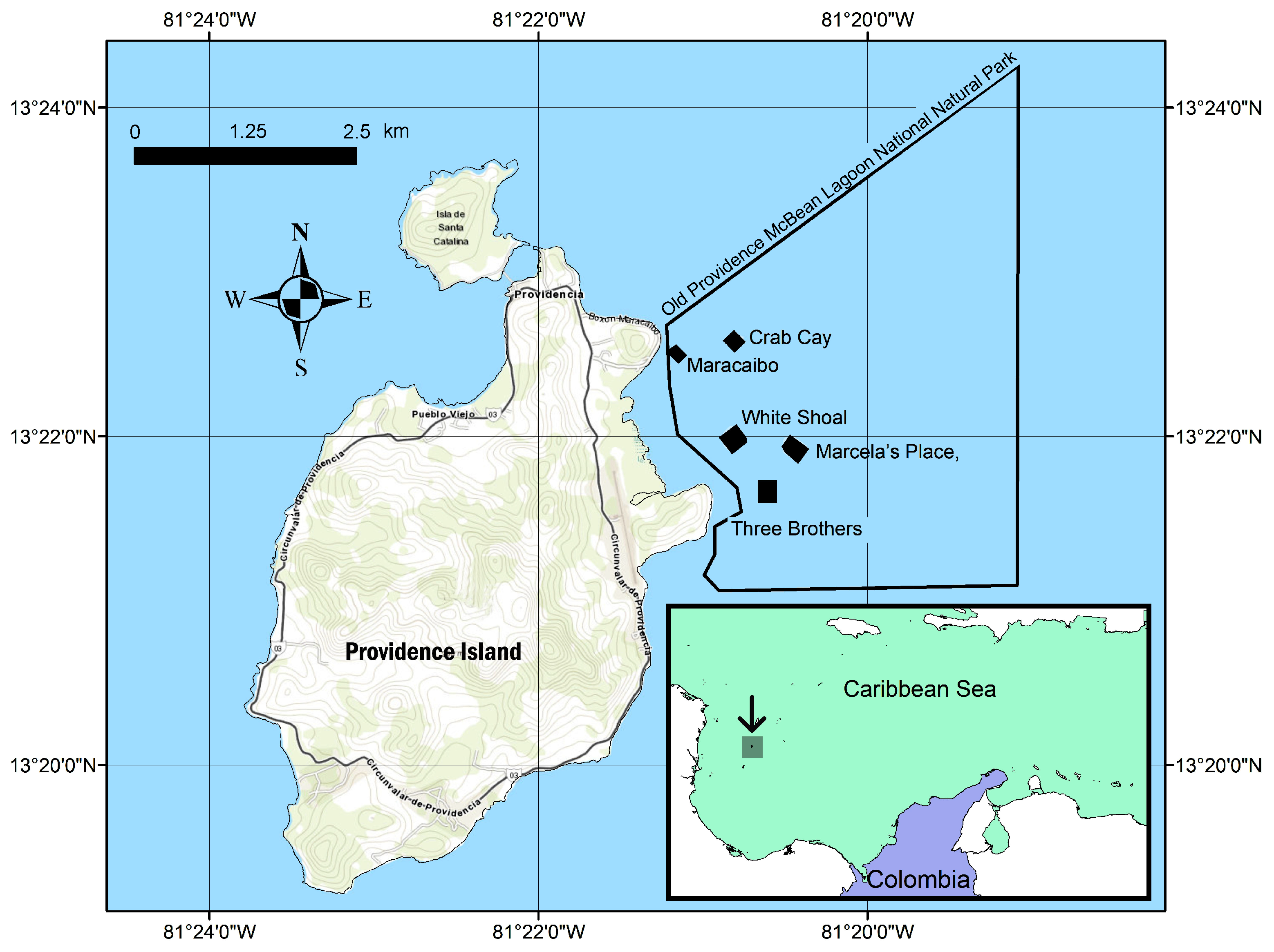
2.1. Study Site
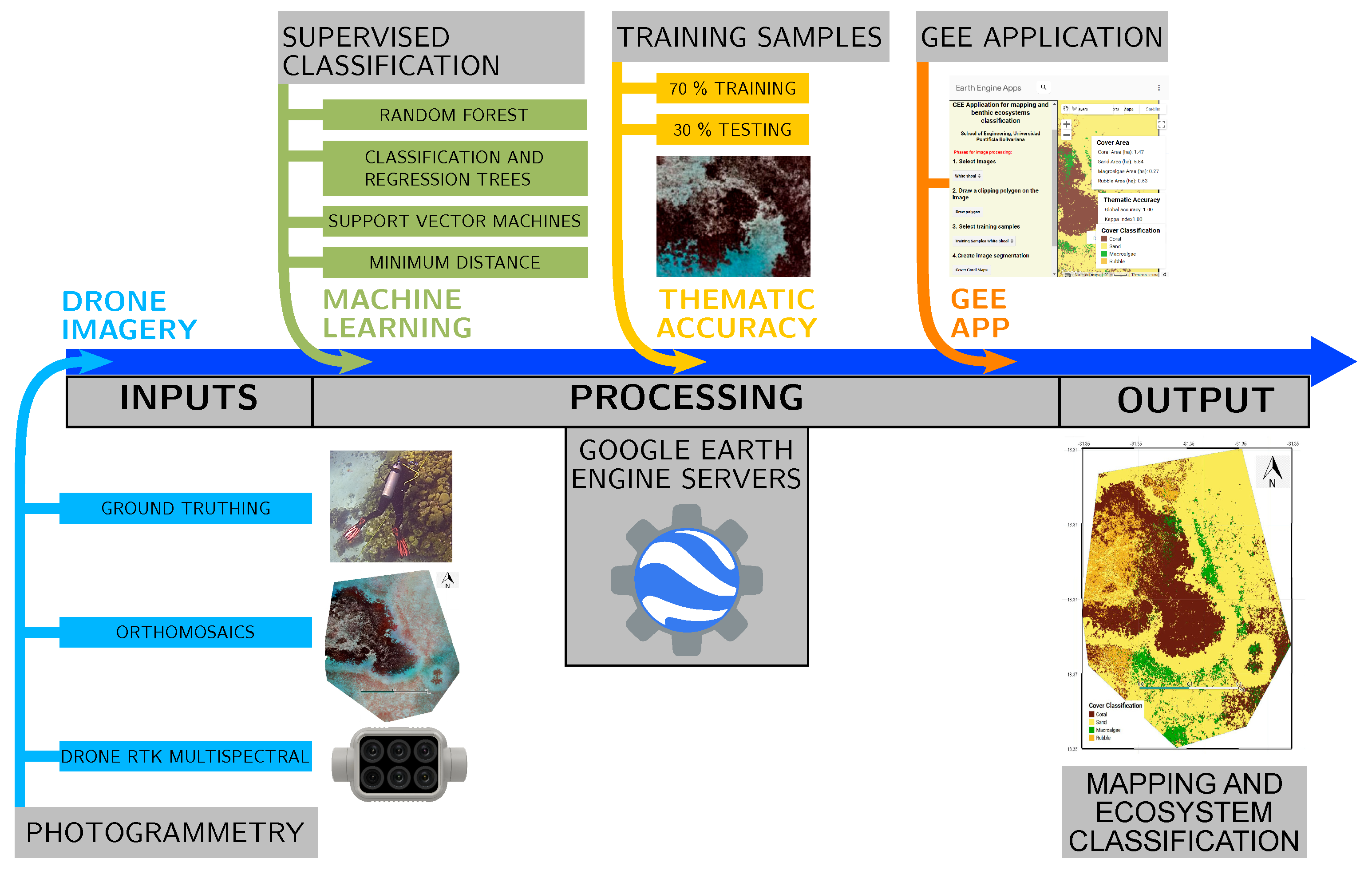
2.2. Data Acquisition
2.3. Data Processing
2.4. Ground Truth Verification points
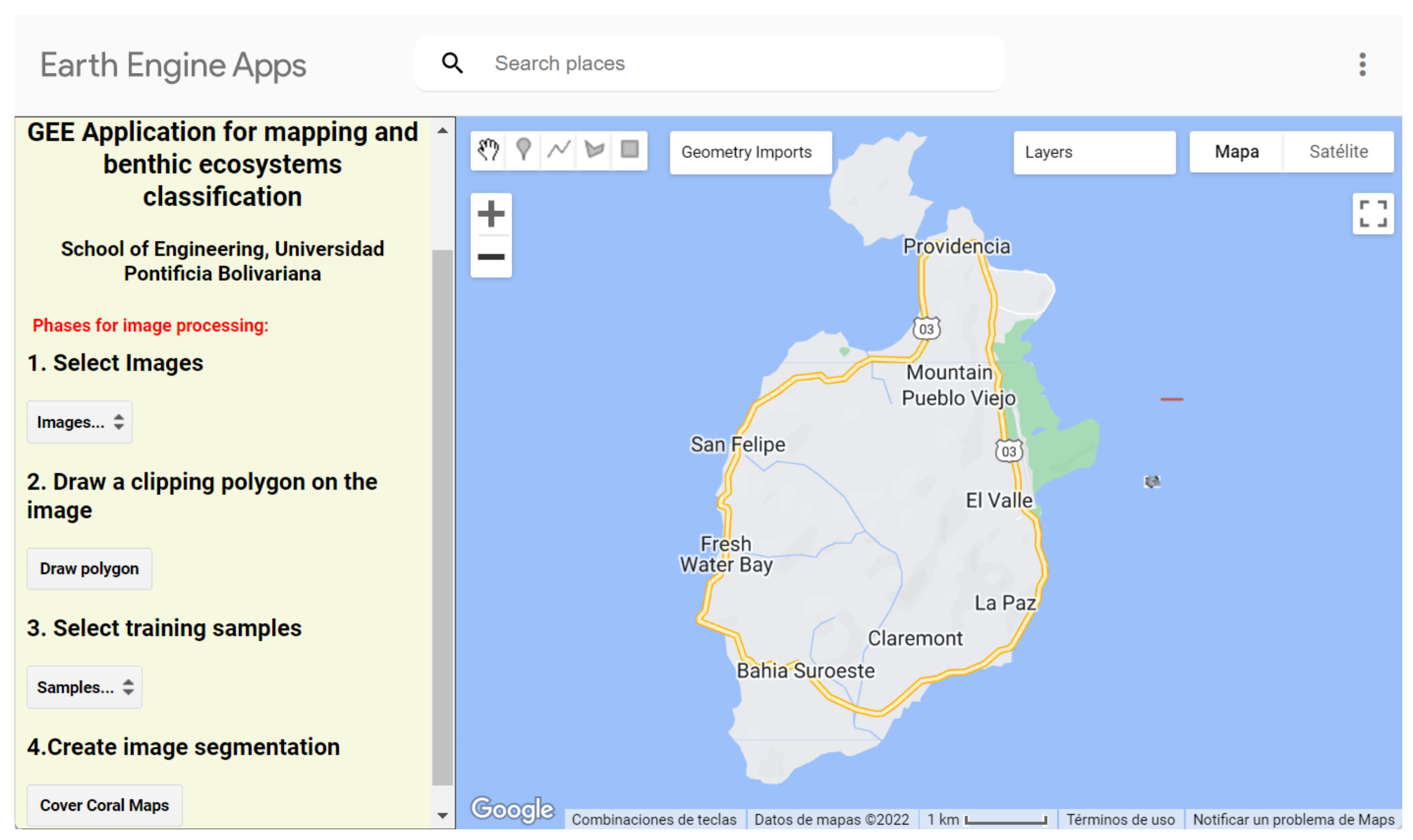
2.5. Reef Habitat Classification through GEE
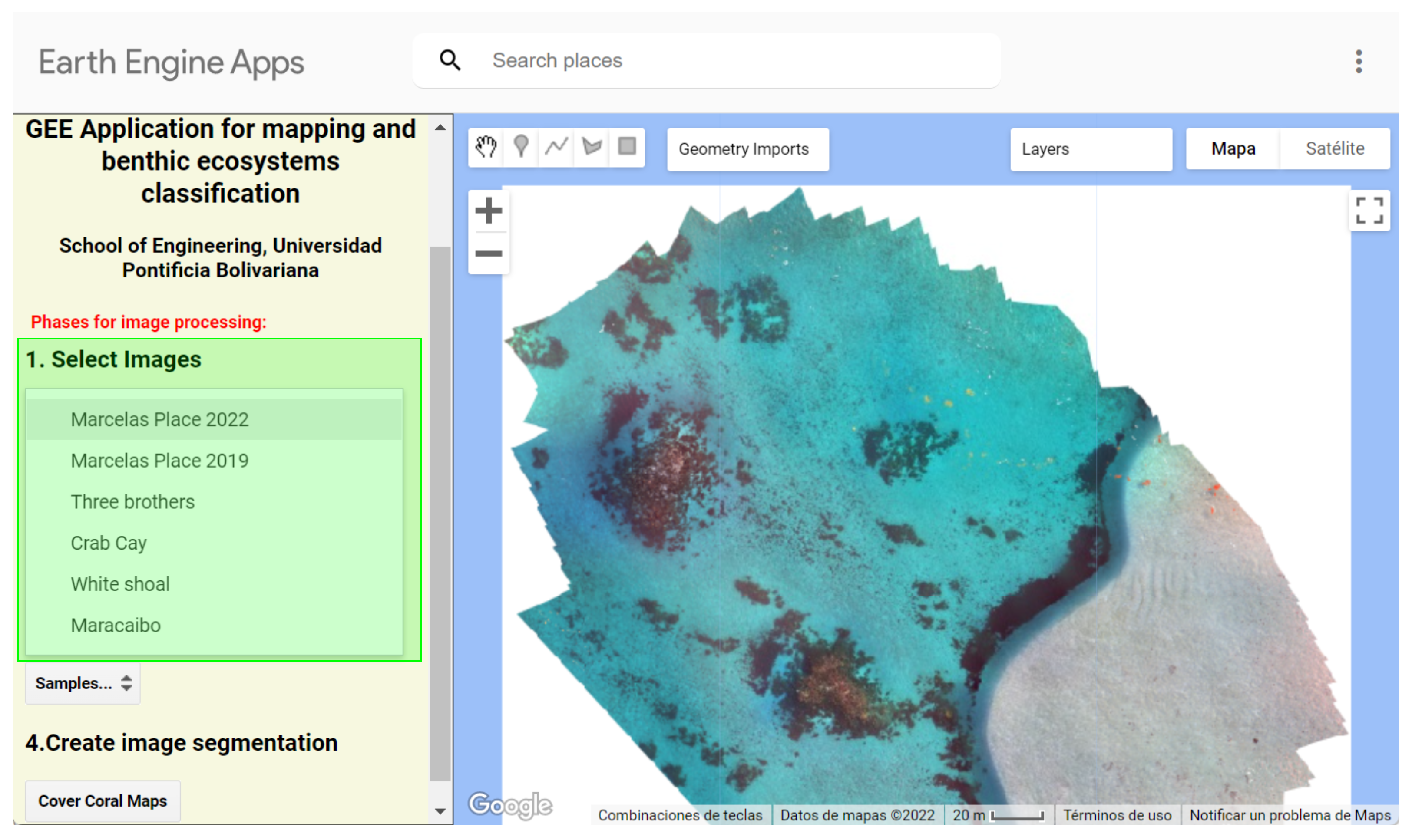
- 1.
- The first section of the panel is to Select images. The user chooses one of the five monitoring reef stations, and the relevant previously imported orthomosaic is called to the platform with the asset tool.
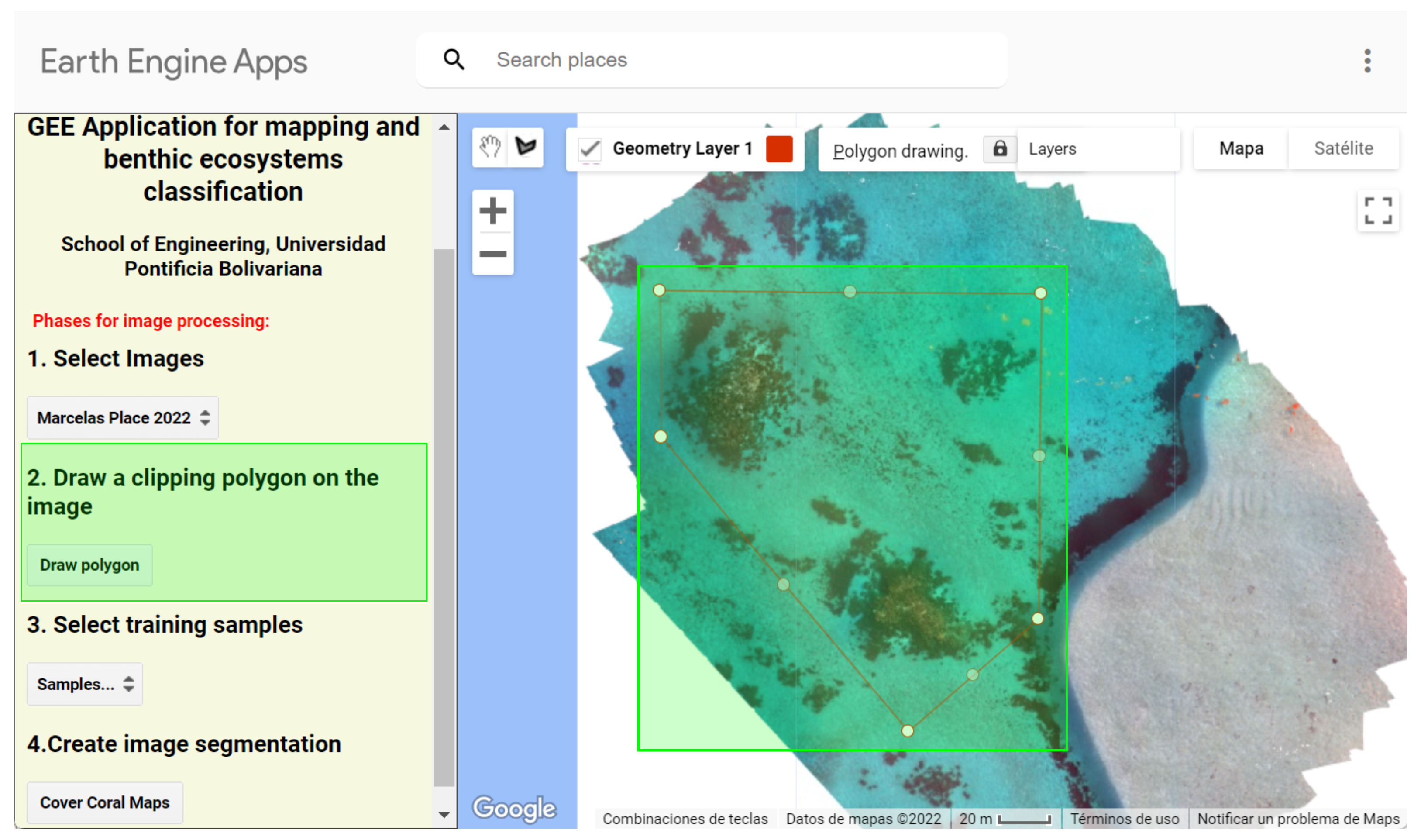
- 2.
- Next, a Draw polygon button is presented for the selection or definition of the evaluation areas, corresponding to the user’s desired coverage(s). The user can select the areas by creating a Feature Collection and using the .clip() function to convert an image into a Geometry.
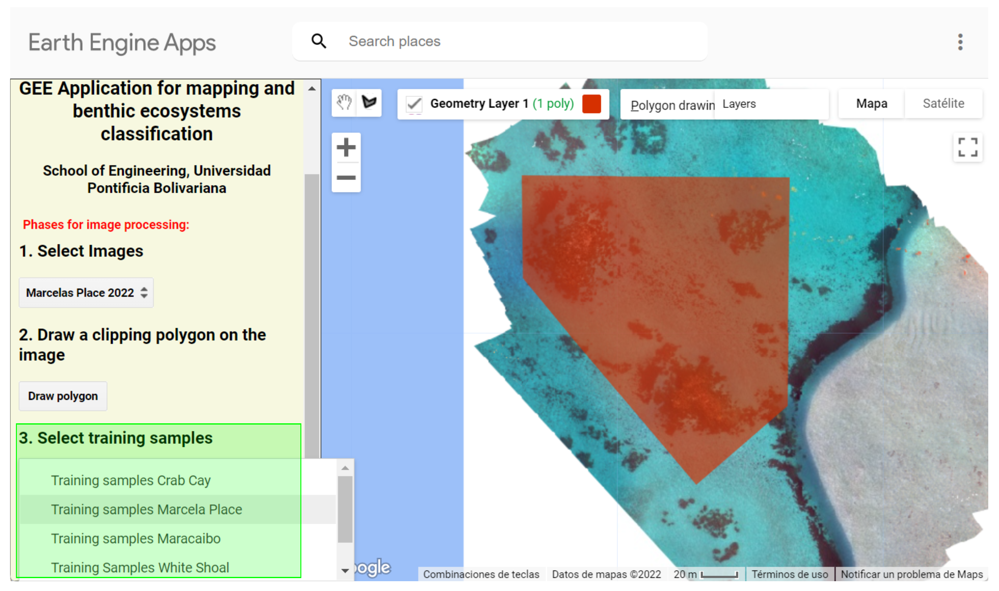
- 3.
- The training sample is created using photos interpreted directly from the API by drawing polygon geometries for each class. These polygons are joined using the .merge() function and then used to train the algorithms. We tested the performance of several algorithms (Random Forest—RF; Minimum Distance—MD; Classification and Regression Trees—CART; and Support Vector Machines—SVM) for habitat reef classification. All the algorithms can be run in the app, but for this work, we chose to show the results of the RF algorithm as an example. RF has been widely used to map reefs in different locations with high accuracy [28,58].
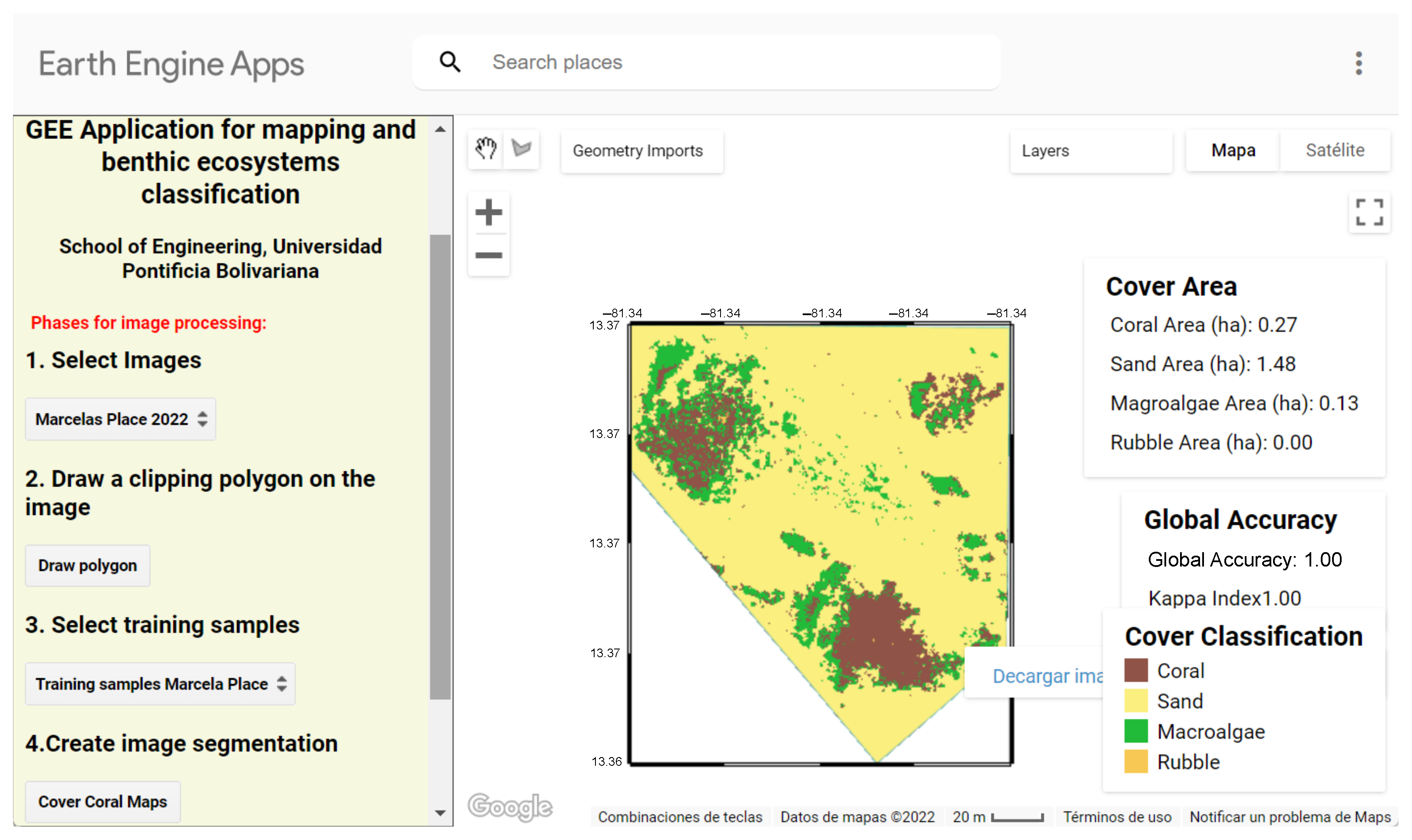
- 4.
- Finally, in the section on creating image segmentation, the Cover Coral Maps button runs the whole process of classification and obtaining thematic accuracy metrics including the Kappa index and the global precision from the confusion matrix obtained with the .ConfusionMatrix() function. The area of each class is calculated by counting the number of pixels and converting them to hectares.
2.6. Accuracy Assessment

3. Results
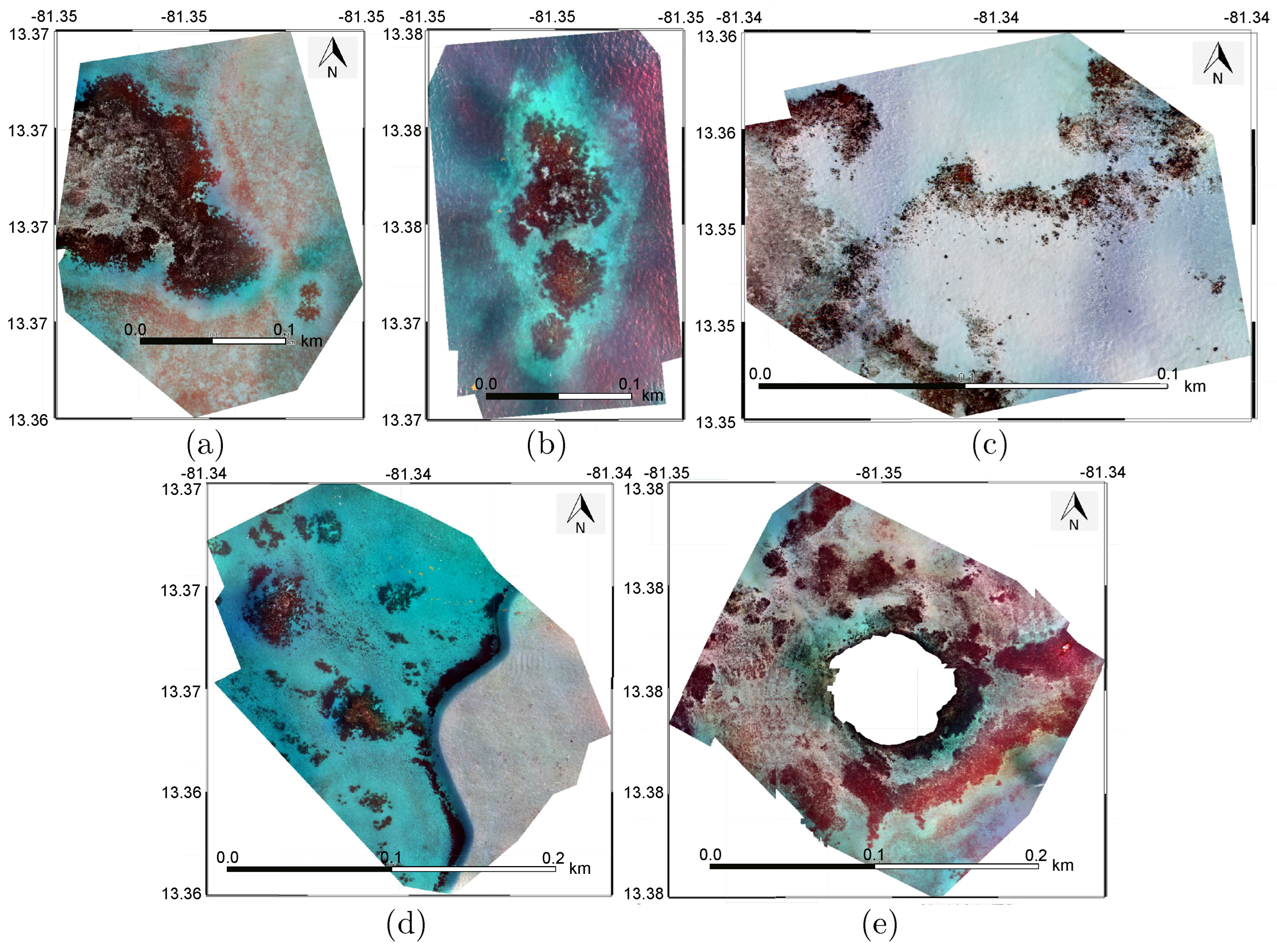
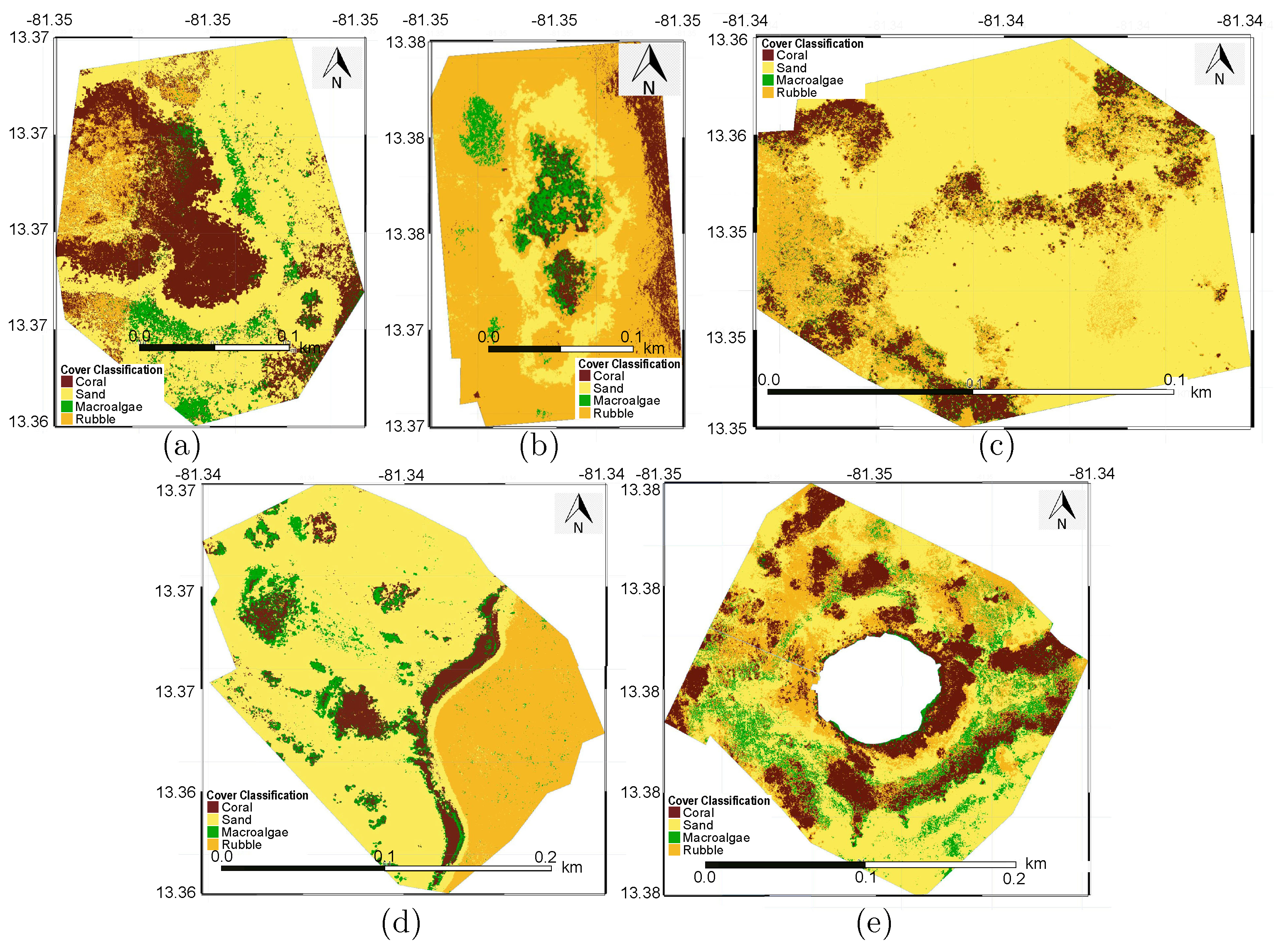
3.1. Drone Imagery
3.2. GEE Application Use
4. Discussion
5. Conclusions
Author Contributions
Funding
Institutional Review Board Statement
Informed Consent Statement
Data Availability Statement
Conflicts of Interest
References
- United Nations. World Population Prospects 2022: Summary of Results; Technical Report DESA/POP/2022/NO.3; United Nations, Department of Economic and Social Affairs, Population Division: New York, NY, USA, 2022. Available online: https://www.un.org/development/desa/pd/content/World-Population-Prospects-2022 (accessed on 15 November 2022.).
- Bethel, B.J.; Buravleva, Y.; Tang, D. Blue Economy and Blue Activities: Opportunities, Challenges, and Recommendations for The Bahamas. Water 2021, 13, 1399. [Google Scholar] [CrossRef]
- Sumaila, U.R.; Walsh, M.; Hoareau, K.; Cox, A.; Teh, L.; Abdallah, P.; Akpalu, W.; Anna, Z.; Benzaken, D.; Crona, B.; et al. Financing a sustainable ocean economy. Nat. Commun. 2021, 12, 3259. [Google Scholar] [CrossRef]
- United Nations. The Sustainable Development Goals Report 2022; Technical Report; United Nations Publications: New York, NY, USA, 2022. Available online: https://unstats.un.org/sdgs/report/2022/ (accessed on 15 November 2022.).
- Bennett, N.J.; Blythe, J.; White, C.S.; Campero, C. Blue growth and blue justice: Ten risks and solutions for the ocean economy. Mar. Policy 2021, 125, 104387. [Google Scholar] [CrossRef]
- Logan, C.A.; Dunne, J.P.; Ryan, J.S.; Baskett, M.L.; Donner, S.D. Quantifying global potential for coral evolutionary response to climate change. Nat. Clim. Chang. 2021, 11, 537–542. [Google Scholar] [CrossRef]
- Talukder, B.; Ganguli, N.; Matthew, R.; vanLoon, G.W.; Hipel, K.W.; Orbinski, J. Climate change-accelerated ocean biodiversity loss & associated planetary health impacts. J. Clim. Chang. Health 2022, 6, 100114. [Google Scholar] [CrossRef]
- McField, M. Impacts of Climate Change on Coral in the Coastal and Marine Environments of Caribbean Small Island Developing States (SIDS). Caribb. Mar. Clim. Chang. Rep. Card Sci. Rev. 2017, 52–59. [Google Scholar]
- Gardner, T.A.; Cote, I.M.; Gill, J.A.; Grant, A.; Watkinson, A.R. Long-Term Region-Wide Declines in Caribbean Corals. Science 2003, 301, 958–960. [Google Scholar] [CrossRef] [Green Version]
- Graham, N.A.J.; Robinson, J.P.W.; Smith, S.E.; Govinden, R.; Gendron, G.; Wilson, S.K. Changing role of coral reef marine reserves in a warming climate. Nat. Commun. 2020, 11, 2000. [Google Scholar] [CrossRef] [Green Version]
- Rhiney, K. Geographies of Caribbean Vulnerability in a Changing Climate: Issues and Trends. Geogr. Compass 2015, 9, 97–114. [Google Scholar] [CrossRef]
- Roth, L.; Kramer, P.; Doyle, E.; O’Sullivan, C. Caribbean SCTLD Dashboard; ArcGIS: Redlands, CA, USA, 2020. [Google Scholar]
- Bayraktarov, E.; Banaszak, A.T.; Maya, P.M.; Kleypas, J.; Arias-González, J.E.; Blanco, M.; Calle-Triviño, J.; Charuvi, N.; Cortés-Useche, C.; Galván, V.; et al. Coral reef restoration efforts in Latin American countries and territories. PLoS ONE 2020, 15, e0228477. [Google Scholar] [CrossRef]
- Curtin, R.; Prellezo, R. Understanding marine ecosystem based management: A literature review. Mar. Policy 2010, 34, 821–830. [Google Scholar] [CrossRef]
- Harvey, B.J.; Nash, K.L.; Blanchard, J.L.; Edwards, D.P. Ecosystem-based management of coral reefs under climate change. Ecol. Evol. 2018, 8, 6354–6368. [Google Scholar] [CrossRef]
- Mcleod, E.; Anthony, K.R.; Mumby, P.J.; Maynard, J.; Beeden, R.; Graham, N.A.; Heron, S.F.; Hoegh-Guldberg, O.; Jupiter, S.; MacGowan, P.; et al. The future of resilience-based management in coral reef ecosystems. J. Environ. Manag. 2019, 233, 291–301. [Google Scholar] [CrossRef] [PubMed]
- Nyman, E. Techno-optimism and ocean governance: New trends in maritime monitoring. Mar. Policy 2019, 99, 30–33. [Google Scholar] [CrossRef]
- Obura, D.O.; Aeby, G.; Amornthammarong, N.; Appeltans, W.; Bax, N.; Bishop, J.; Brainard, R.E.; Chan, S.; Fletcher, P.; Gordon, T.A.C.; et al. Coral Reef Monitoring, Reef Assessment Technologies, and Ecosystem-Based Management. Front. Mar. Sci. 2019, 6, 580. [Google Scholar] [CrossRef] [Green Version]
- Turner, R.A.; Forster, J.; Fitzsimmons, C.; Mahon, R. Expanding narratives of governance constraints to improve coral reef conservation. Conserv. Biol. 2022, 36, e13933. [Google Scholar] [CrossRef]
- Morrison, T.H.; Adger, N.; Barnett, J.; Brown, K.; Possingham, H.; Hughes, T. Advancing Coral Reef Governance into the Anthropocene. One Earth 2020, 2, 64–74. [Google Scholar] [CrossRef] [Green Version]
- Eddy, T.D.; Lam, V.W.; Reygondeau, G.; Cisneros-Montemayor, A.M.; Greer, K.; Palomares, M.L.D.; Bruno, J.F.; Ota, Y.; Cheung, W.W. Global decline in capacity of coral reefs to provide ecosystem services. One Earth 2021, 4, 1278–1285. [Google Scholar] [CrossRef]
- Hamylton, S.M.; Zhou, Z.; Wang, L. What Can Artificial Intelligence Offer Coral Reef Managers? Front. Mar. Sci. 2020, 7, 1049. [Google Scholar] [CrossRef]
- Cowburn, B.; Alliji, K.; Bluemel, J.K.; Couce, E.; Lawrance, E.; McManus, E.; van Hoytema, N.; Devlin, M. Ecosystem-based management of coral reefs from afar—A guide for remote scientists and remote places. Environ. Sci. Policy 2023, 139, 29–38. [Google Scholar] [CrossRef]
- Hedley, J.; Roelfsema, C.; Chollett, I.; Harborne, A.; Heron, S.; Weeks, S.; Skirving, W.; Strong, A.; Eakin, C.; Christensen, T.; et al. Remote Sensing of Coral Reefs for Monitoring and Management: A Review. Remote. Sens. 2016, 8, 118. [Google Scholar] [CrossRef] [Green Version]
- Lyons, M.B.; Roelfsema, C.M.; Kennedy, E.V.; Kovacs, E.M.; Borrego-Acevedo, R.; Markey, K.; Roe, M.; Yuwono, D.M.; Harris, D.L.; Phinn, S.R.; et al. Mapping the world’s coral reefs using a global multiscale earth observation framework. Remote. Sens. Ecol. Conserv. 2020, 6, 557–568. [Google Scholar] [CrossRef] [Green Version]
- Casella, E.; Collin, A.; Harris, D.; Ferse, S.; Bejarano, S.; Parravicini, V.; Hench, J.L.; Rovere, A. Mapping coral reefs using consumer-grade drones and structure from motion photogrammetry techniques. Coral Reefs 2016, 36, 269–275. [Google Scholar] [CrossRef]
- Lopera-Gil, M.; Vásquez, R.E.; Zuluaga, C.A.; Zapata-Ramírez, P.A. On the Use of Consumer-Grade Remotely Piloted Aircraft Systems for Monitoring Shallow Coral Reefs in Colombia: Case Old Providence Island. In Proceedings of the ASME 38th International Conference on Ocean, Offshore and Arctic Engineering OMAE Volume 6: Ocean Space Utilization. American Society of Mechanical Engineers, Glasgow, Scotland, 9–14 June 2019. [Google Scholar] [CrossRef]
- Bennett, M.K.; Younes, N.; Joyce, K. Automating Drone Image Processing to Map Coral Reef Substrates Using Google Earth Engine. Drones 2020, 4, 50. [Google Scholar] [CrossRef]
- Sierra-Escrigas, S.L.; Peluffo, D.R.; García-Urueña, R. Shallow coral reef community mapping and update on its ecological units using aerial images at Isla Arena, Colombian Caribbean. Int. J. Remote. Sens. 2020, 41, 8198–8215. [Google Scholar] [CrossRef]
- Fallati, L.; Saponari, L.; Savini, A.; Marchese, F.; Corselli, C.; Galli, P. Multi-Temporal UAV Data and Object-Based Image Analysis (OBIA) for Estimation of Substrate Changes in a Post-Bleaching Scenario on a Maldivian Reef. Remote. Sens. 2020, 12, 2093. [Google Scholar] [CrossRef]
- Kennedy, E.V.; Roelfsema, C.M.; Lyons, M.B.; Kovacs, E.M.; Borrego-Acevedo, R.; Roe, M.; Phinn, S.R.; Larsen, K.; Murray, N.J.; Yuwono, D.; et al. Reef Cover, a coral reef classification for global habitat mapping from remote sensing. Sci. Data 2021, 8, 196. [Google Scholar] [CrossRef]
- Nababan, B.; Mastu, L.O.K.; Idris, N.H.; Panjaitan, J.P. Shallow-Water Benthic Habitat Mapping Using Drone with Object Based Image Analyses. Remote. Sens. 2021, 13, 4452. [Google Scholar] [CrossRef]
- Borges, D.; Padua, L.; Azevedo, I.C.; Silva, J.; Sousa, J.J.; Sousa-Pinto, I.; Goncalves, J.A. Classification of an Intertidal Reef by Machine Learning Techniques Using UAV Based RGB and Multispectral Imagery. In Proceedings of the 2021 IEEE International Geoscience and Remote Sensing Symposium IGARSS, Brussels, Belgium, 11–16 July 2021. [Google Scholar] [CrossRef]
- Mat-Zaki, N.H.; Chong, W.S.; Muslim, A.M.; Reba, M.N.M.; Hossain, M.S. Assessing optimal UAV-data pre-processing workflows for quality ortho-image generation to support coral reef mapping. Geocarto Int. 2022, 37, 1–25. [Google Scholar] [CrossRef]
- Nieuwenhuis, B.O.; Marchese, F.; Casartelli, M.; Sabino, A.; van der Meij, S.E.T.; Benzoni, F. Integrating a UAV-Derived DEM in Object-Based Image Analysis Increases Habitat Classification Accuracy on Coral Reefs. Remote. Sens. 2022, 14, 5017. [Google Scholar] [CrossRef]
- Alevizos, E.; Alexakis, D.D. Monitoring Short-Term Morphobathymetric Change of Nearshore Seafloor Using Drone-Based Multispectral Imagery. Remote. Sens. 2022, 14, 6035. [Google Scholar] [CrossRef]
- Gorelick, N.; Hancher, M.; Dixon, M.; Ilyushchenko, S.; Thau, D.; Moore, R. Google Earth Engine: Planetary-scale geospatial analysis for everyone. Remote. Sens. Environ. 2017, 202, 18–27. [Google Scholar] [CrossRef]
- Kumar, L.; Mutanga, O. Google Earth Engine Applications Since Inception: Usage, Trends, and Potential. Remote. Sens. 2018, 10, 1509. [Google Scholar] [CrossRef] [Green Version]
- Mutanga, O.; Kumar, L. Google Earth Engine Applications. Remote. Sens. 2019, 11, 591. [Google Scholar] [CrossRef] [Green Version]
- Amani, M.; Ghorbanian, A.; Ahmadi, S.A.; Kakooei, M.; Moghimi, A.; Mirmazloumi, S.M.; Moghaddam, S.H.A.; Mahdavi, S.; Ghahremanloo, M.; Parsian, S.; et al. Google Earth Engine Cloud Computing Platform for Remote Sensing Big Data Applications: A Comprehensive Review. IEEE J. Sel. Top. Appl. Earth Obs. Remote. Sens. 2020, 13, 5326–5350. [Google Scholar] [CrossRef]
- Tamiminia, H.; Salehi, B.; Mahdianpari, M.; Quackenbush, L.; Adeli, S.; Brisco, B. Google Earth Engine for geo-big data applications: A meta-analysis and systematic review. ISPRS J. Photogramm. Remote. Sens. 2020, 164, 152–170. [Google Scholar] [CrossRef]
- Zhao, Q.; Yu, L.; Li, X.; Peng, D.; Zhang, Y.; Gong, P. Progress and Trends in the Application of Google Earth and Google Earth Engine. Remote. Sens. 2021, 13, 3778. [Google Scholar] [CrossRef]
- Yang, L.; Driscol, J.; Sarigai, S.; Wu, Q.; Chen, H.; Lippitt, C.D. Google Earth Engine and Artificial Intelligence (AI): A Comprehensive Review. Remote. Sens. 2022, 14, 3253. [Google Scholar] [CrossRef]
- Yancho, J.; Jones, T.; Gandhi, S.; Ferster, C.; Lin, A.; Glass, L. The Google Earth Engine Mangrove Mapping Methodology (GEEMMM). Remote. Sens. 2020, 12, 3758. [Google Scholar] [CrossRef]
- Williamson, M.J.; Tebbs, E.J.; Thompson, H.J.; Dawson, T.P.; Head, C.E.I.; Jacoby, D.M.P. Application of Earth Observation Data and Google Earth Engine for Monitoring Coral Reef Exposure to Environmental Stressors. Preprints 2021, 2021060473. [Google Scholar] [CrossRef]
- de Lima, L.T.; Fernández-Fernández, S.; Gonçalves, J.F.; Filho, L.M.; Bernardes, C. Development of Tools for Coastal Management in Google Earth Engine: Uncertainty Bathtub Model and Bruun Rule. Remote. Sens. 2021, 13, 1424. [Google Scholar] [CrossRef]
- Li, J.; Knapp, D.E.; Lyons, M.; Roelfsema, C.; Phinn, S.; Schill, S.R.; Asner, G.P. Automated Global Shallow Water Bathymetry Mapping Using Google Earth Engine. Remote. Sens. 2021, 13, 1469. [Google Scholar] [CrossRef]
- Callejas, I.A.; Osborn, K.; Lee, C.; Mishra, D.R.; Gomez, N.A.; Carrias, A.; Cherrington, E.A.; Griffin, R.; Rosado, A.; Rosado, S.; et al. A GEE toolkit for water quality monitoring from 2002 to 2022 in support of SDG 14 and coral health in marine protected areas in Belize. Front. Remote. Sens. 2022, 3, 103. [Google Scholar] [CrossRef]
- INVEMAR. Manual de Métodos del SIMAC (Sistema Nacional de Monitoreo de Arrecifes Coralinos); Instituto De Investigaciones Marinas y Costeras “José Benito Vives De Andréis”; INVEMAR: Santa Marta, Colombia, 2002.
- Sánchez, J.A.; Zea, S.; Díaz, J.M. Patterns of Octocoral and Black Coral Distribution in the Oceanic Barrier Reef-complex of Providencia Island, Southwestern Caribbean. Caribb. J. Sci. 1998, 34, 250–264. [Google Scholar]
- Díaz, J.M.; Barrios, L.M.; Cendales, M.H.; Garzón-Ferreira, J.; Geister, J.; López-Victoria, M.; Ospina, G.H.; Parra-Velandia, F.; Pinzón, J.; Vargas-Angel, B.; et al. Áreas Coralinas de Colombia; Serie Publicaciones Especiales No.5; Instituto de Investigaciones Marinas y Costeras “José Benito Vives De Andréis”; INVEMAR: Santa Marta, Colombia, 2000.
- Geister, J. Modern reef development and cenozoic evolution of an oceanic island/reef complex: Isla de Providencia (Western Caribbean sea, Colombia). Facies 1992, 27, 1–69. [Google Scholar] [CrossRef]
- Geister, J.; Díaz, J.M. Reef Environments and Geology of an Oceanic Archipelago: San Andrés, Providence and Santa Catalina (Caribbean Sea, Colombia); Ministerio de Minas: Bogotá, Colombia; INGEOMINAS: Bogotá, Colombia, 2007.
- Rodríguez-Ramírez, A.; Reyes-Nivia, M.C.; Zea, S.; Navas-Camacho, R.; Garzón-Ferreira, J.; Bejarano, S.; Herrón, P.; Orozco, C. Recent dynamics and condition of coral reefs in the Colombian Caribbean. Rev. Biol. Trop. Int. J. Trop. Biol. Conserv. 2010, 58, 107–131. [Google Scholar] [CrossRef] [Green Version]
- DJI. Phantom 4 RTK. 2022. Available online: https://www.dji.com/phantom-4-rtk (accessed on 15 November 2022).
- DJI. Phantom 4 Multispectral. 2022. Available online: https://www.dji.com/p4-multispectral (accessed on 15 November 2022).
- Agisoft. Agisoft. 2022. Available online: https://www.agisoft.com/ (accessed on 15 November 2022).
- Wicaksono, P.; Aryaguna, P.A.; Lazuardi, W. Benthic Habitat Mapping Model and Cross Validation Using Machine-Learning Classification Algorithms. Remote. Sens. 2019, 11, 1279. [Google Scholar] [CrossRef] [Green Version]
- De’Ath, G.; Fabricius, K.E. Classification and regression trees: A powerful yet simple technique for ecological data analysis. Ecology 2000, 81, 3178–3192. [Google Scholar] [CrossRef]
- Burns, C.; Bollard, B.; Narayanan, A. Machine-Learning for Mapping and Monitoring Shallow Coral Reef Habitats. Remote. Sens. 2022, 14, 2666. [Google Scholar] [CrossRef]
- Liu, P.; Choo, K.K.R.; Wang, L.; Huang, F. SVM or deep learning? A comparative study on remote sensing image classification. Soft Comput. 2016, 21, 7053–7065. [Google Scholar] [CrossRef]
- Bishop, C.M. Pattern Recognition and Machine Learning; Information Science and Statistics; Springer: New York, NY, USA, 2006. [Google Scholar]
- Roelfsema, C. Integrating field data with high spatial resolution multispectral satellite imagery for calibration and validation of coral reef benthic community maps. J. Appl. Remote. Sens. 2010, 4, 043527. [Google Scholar] [CrossRef] [Green Version]
- Teluguntla, P.; Thenkabail, P.S.; Oliphant, A.; Xiong, J.; Gumma, M.K.; Congalton, R.G.; Yadav, K.; Huete, A. A 30-m landsat-derived cropland extent product of Australia and China using random forest machine learning algorithm on Google Earth Engine cloud computing platform. ISPRS J. Photogramm. Remote. Sens. 2018, 144, 325–340. [Google Scholar] [CrossRef]
- Chuvieco, E. Fundamentals of Satellite Remote Sensing: An Environmental Approach, 2nd ed.; CRC Press: Boca Raton, FL, USA, 2016. [Google Scholar]
- Hernández, H.; Zapata, P. GEE Application for Mapping and Benthic Ecosystems Classification. 2022. Available online: https://nandoceanos.users.earthengine.app/view/coralclass (accessed on 15 November 2022).
- Mumby, P.J. Remote Sensing Handbook for Tropical Coastal Management; Chapter Methodologies for Defining Habitats; UNESCO: Paris, France, 2000; pp. 131–140. [Google Scholar]
- Hernández, H.; Zapata-Ramírez, P.; Vásquez, R.E.; Zuluaga, C.A.; Santana-Mejía, J.D.; Cano, M. Climate Change Adaptation and Mitigation in the Seaflower Biosphere Reserve: From Local Thinking to Global Actions; Chapter Rapid remote sensing assessment of impacts from Hurricane Iota on the coral reef geomorphic zonation in Providencia; Springer Nature: Berlin/Heidelberg, Germany, 2023; In press. [Google Scholar]
- Rey, W.; Ruiz-Salcines, P.; Salles, P.; Urbano-Latorre, C.P.; Escobar-Olaya, G.; Osorio, A.F.; Ramírez, J.P.; Cabarcas-Mier, A.; Jigena-Antelo, B.; Appendini, C.M. Hurricane Flood Hazard Assessment for the Archipelago of San Andres, Providencia and Santa Catalina, Colombia. Front. Mar. Sci. 2021, 8, 766258. [Google Scholar] [CrossRef]
- Zapata-Ramírez, P.A.; Blanchon, P.; Olioso, A.; Hernandez-Nuñez, H.; Sobrino, J.A. Accuracy of IKONOS for mapping benthic coral-reef habitats: A case study from the Puerto Morelos Reef National Park, Mexico. Int. J. Remote. Sens. 2012, 34, 3671–3687. [Google Scholar] [CrossRef]
- Yang, C.; Yu, M.; Hu, F.; Jiang, Y.; Li, Y. Utilizing Cloud Computing to address big geospatial data challenges. Comput. Environ. Urban Syst. 2017, 61, 120–128. [Google Scholar] [CrossRef] [Green Version]
- Nietupski, T.C.; Kennedy, R.E.; Temesgen, H.; Kerns, B.K. Spatiotemporal image fusion in Google Earth Engine for annual estimates of land surface phenology in a heterogenous landscape. Int. J. Appl. Earth Obs. Geoinf. 2021, 99, 102323. [Google Scholar] [CrossRef]


| Class | White Shoal | Maracaibo | Three Brothers | Marcela’s Place | Crab Cay |
|---|---|---|---|---|---|
| (px) | (px) | (px) | (px) | (px) | |
| Coral | 695 | 48 | 160 | 730 | 124 |
| Sand | 958 | 115 | 2122 | 3226 | 1312 |
| Macroalgae | 287 | 22 | 6 | 408 | 28 |
| Rubble | 79 | 55 | 35 | 7 | 180 |
| Site | Index | MD | RF | CART | SVM |
|---|---|---|---|---|---|
| White Shoal | Kappa | 0.8138 | 0.9961 | 1.0000 | 0.9394 |
| Precision | 0.8752 | 0.9975 | 1.0000 | 0.9394 | |
| Maracaibo | Kappa | 0.9197 | 1.0000 | 1.0000 | 1.0000 |
| Precision | 0.9458 | 1.0000 | 1.0000 | 1.0000 | |
| Three Brothers | Kappa | 0.5275 | 0.9993 | 1.0000 | 0.9617 |
| Precision | 0.7216 | 0.9991 | 1.0000 | 0.9256 | |
| Marcela’s Place | Kappa | 0.5275 | 0.9984 | 1.0000 | 0.9617 |
| Precision | 0.7216 | 0.9984 | 1.0000 | 0.9839 | |
| Crab Cay | Kappa | 0.7351 | 0.9982 | 1.0000 | 0.9664 |
| Precision | 0.8996 | 0.9994 | 1.0000 | 0.9664 |
| Class | White Shoal | Maracaibo | Three Brothers | Marcela’s Place | Crab Cay |
|---|---|---|---|---|---|
| (ha) | (ha) | (ha) | (ha) | (ha) | |
| Coral | 1.64 | 0.28 | 0.22 | 0.62 | 1.26 |
| Sand | 2.85 | 0.45 | 1.39 | 4.27 | 2.40 |
| Macroalgae | 0.20 | 0.17 | 0.01 | 0.38 | 0.69 |
| Rubble | 0.59 | 2.02 | 0.53 | 1.68 | 1.93 |
| White Shoal | Maracaibo | Three Brothers | Marcela’s Place | Crab Cay | ||||||||||||||||
|---|---|---|---|---|---|---|---|---|---|---|---|---|---|---|---|---|---|---|---|---|
| C | S | M | R | C | S | M | R | C | S | M | R | C | S | M | R | C | S | M | R | |
| C | 694 | 1 | 0 | 0 | 124 | 0 | 0 | 0 | 160 | 0 | 0 | 0 | 729 | 0 | 1 | 0 | 124 | 0 | 0 | 0 |
| S | 0 | 958 | 0 | 0 | 0 | 1312 | 0 | 0 | 0 | 2102 | 0 | 0 | 0 | 3226 | 0 | 0 | 0 | 1312 | 0 | 0 |
| M | 1 | 0 | 286 | 0 | 0 | 0 | 28 | 0 | 0 | 0 | 6 | 0 | 2 | 0 | 406 | 0 | 0 | 0 | 28 | 0 |
| R | 2 | 1 | 0 | 76 | 0 | 0 | 1 | 179 | 0 | 2 | 0 | 33 | 0 | 0 | 0 | 7 | 0 | 0 | 1 | 179 |
Disclaimer/Publisher’s Note: The statements, opinions and data contained in all publications are solely those of the individual author(s) and contributor(s) and not of MDPI and/or the editor(s). MDPI and/or the editor(s) disclaim responsibility for any injury to people or property resulting from any ideas, methods, instructions or products referred to in the content. |
© 2023 by the authors. Licensee MDPI, Basel, Switzerland. This article is an open access article distributed under the terms and conditions of the Creative Commons Attribution (CC BY) license (https://creativecommons.org/licenses/by/4.0/).
Share and Cite
Zapata-Ramírez, P.A.; Hernández-Hamón, H.; Fitzsimmons, C.; Cano, M.; García, J.; Zuluaga, C.A.; Vásquez, R.E. Development of a Google Earth Engine-Based Application for the Management of Shallow Coral Reefs Using Drone Imagery. Remote Sens. 2023, 15, 3504. https://doi.org/10.3390/rs15143504
Zapata-Ramírez PA, Hernández-Hamón H, Fitzsimmons C, Cano M, García J, Zuluaga CA, Vásquez RE. Development of a Google Earth Engine-Based Application for the Management of Shallow Coral Reefs Using Drone Imagery. Remote Sensing. 2023; 15(14):3504. https://doi.org/10.3390/rs15143504
Chicago/Turabian StyleZapata-Ramírez, Paula A., Hernando Hernández-Hamón, Clare Fitzsimmons, Marcela Cano, Julián García, Carlos A. Zuluaga, and Rafael E. Vásquez. 2023. "Development of a Google Earth Engine-Based Application for the Management of Shallow Coral Reefs Using Drone Imagery" Remote Sensing 15, no. 14: 3504. https://doi.org/10.3390/rs15143504