Review

UAV Implementations in Urban Planning and Related Sectors of Rapidly Developing Nations: A Review and Future Perspectives for Malaysia

by
Aisyah Marliza Muhmad Kamarulzaman
1,
Wan Shafrina Wan Mohd Jaafar
1,*,
Mohd Nizam Mohd Said
1,2,
Siti Nor Maizah Saad
1,3 and
Midhun Mohan
4,5
1
Earth Observation Centre, Institute of Climate Change, National University of Malaysia (UKM), Bangi 43600, Malaysia
2
Department of Biological Sciences and Biotechnology, Faculty of Science and Technology, Universiti Kebangsaan Malaysia, Bangi 43600, Malaysia
3
College of Built Environment, Universiti Teknologi MARA Perlis Branch, Arau 02600, Malaysia
4
Department of Geography, University of California-Berkeley, Berkeley, CA 94709, USA
5
Ecoresolve Inc., San Francisco, CA 94105, USA
*
Author to whom correspondence should be addressed.
Remote Sens. 2023, 15(11), 2845; https://doi.org/10.3390/rs15112845
Submission received: 18 April 2023 / Revised: 24 May 2023 / Accepted: 27 May 2023 / Published: 30 May 2023

Abstract

:
The rapid growth of urban populations and the need for sustainable urban planning and development has made Unmanned Aerial Vehicles (UAVs) a valuable tool for data collection, mapping, and monitoring. This article reviews the applications of UAV technology in sustainable urban development, particularly in Malaysia. It explores the potential of UAVs to transform infrastructure projects and enhance urban systems, underscoring the importance of advanced applications in Southeast Asia and developing nations worldwide. Following the PRISMA 2020 statement, this article adopts a systematic review process and identifies 98 relevant studies out of 591 records, specifically examining the use of UAVs in urban planning. The emergence of the UAV-as-a-service sector has led to specialized companies offering UAV operations for site inspections, 3D modeling of structures and terrain, boundary assessment, area estimation, master plan formulation, green space analysis, environmental monitoring, and archaeological monument mapping. UAVs have proven to be versatile tools with applications across multiple fields, including precision agriculture, forestry, construction, surveying, disaster response, security, and education. They offer advantages such as high-resolution imagery, accessibility, and operational safety. Varying policies and regulations concerning UAV usage across countries present challenges for commercial and research UAVs. In Malaysia, UAVs have become essential in addressing challenges associated with urbanization, including traffic congestion, urban sprawl, pollution, and inadequate social facilities. However, several obstacles need to be overcome before UAVs can be effectively deployed, including regulatory barriers, limited flight time and range, restricted awareness, lack of skilled personnel, and concerns regarding security and privacy. Successful implementation requires coordination among public bodies, industry stakeholders, and the public. Future research in Malaysia should prioritize 3D modeling and building identification, using the results of this study to propel advancements in other ASEAN countries.

Graphical Abstract

1. Introduction

Any country’s key economic objectives include urban planning and development, which is attributed to a variety of factors, with the most important being the country’s growing population [1]. To ensure the sustainable growth of cities and to fulfill the exploding demands of their inhabitants, population growth results in the need for increased quantities of resources, new development and optimized residential strategies, land-use/land-cover change policy amendments, and additional environmental management systems. Along with that, there exists an implicit obligation to ensure that the introduction of modern buildings and urban housing schemes does not dismantle the palimpsests of a country’s celebrated past; these heritage monuments hold a colossal amount of unique tales traced from its history that the coming generations can learn from Abdullah et al. [2] From this point of view, current and comprehensive data on the nature and expansion of urban systems on both a regional and global scale are essential for the proper development of any nation and its many cities [3]. The quick expansion of cities, the process of becoming more urbanized, and the difficulties that come with expansion have resulted from the migration of more than half of the populations of rapidly developing nations such as Malaysia, Indonesia, and Thailand [4]. The informal growth of cities in developing regions such as South America and Asia is a complex phenomenon that has several underlying factors. Rapid urbanization, population growth, limited resources, and inadequate urban planning are some of the key drivers behind this informal growth.
Urbanization refers to the change in the proportion of individuals residing in rural versus urban areas, and it should not be combined with urban growth, which measures changes within urban zones. Cities such as Kuala Lumpur, Jakarta, and Bangkok, which serve as hubs for society, politics, commerce, and the arts, are prime examples of where this phenomenon is observable. These crises emphasize the pressing requirement to develop sustainable urban planning strategies that safeguard historic sites, expand green spaces, reduce inequalities in wealth distribution, regulate pollution and carbon emissions, and cater to citizens’ needs through active public participation [5,6]. These strategies must also adhere to the development control guidelines, protocols, and policies established by their respective legislative and administrative bodies. Since limitations frequently constrain these approaches, such as time, capital, and labor availability, we cannot identify or solve these problems by solely relying on conventional data collection methods, such as obtaining the information through statistics and field surveys [7].
Mapping from airborne aerial images might be considered a solution for addressing the shortcomings of conventional field-based methods, but its poor spatial and temporal resolution puts constraints on its effectiveness [8]. Recently, emerging remote sensing methods and land-observation-driven spatial modeling approaches have begun to take root in Malaysia and have been developed as viable instruments for supplying current data with sufficient detail to advance the urban sector as well as its strategic planning [9]. Most of the ongoing remote-sensing-based urban development applications employ publicly available optical imagery and, in some instances, airborne laser scanning data (light detection and ranging; LiDAR) or Geographical Information System (GIS) tools were used. For instance, Nor et al. [10] utilized temporal SPOT satellite imagery to analyze the land-use cover change in Melaka City. Using the supervised classification method, Malaysia was able to effectively categorize three types of land use—built-up areas, green spaces, and water bodies. The authors highlighted the prospects of monitoring land-use changes in historical cities using remote sensing techniques; the results are useful to the authorities who are accountable for the creation and maintenance of resilient and sustainable environments. Nevertheless, restrained flexibility in positioning the focus, insufficient spatial resolution, and disturbances caused by clouds and lags in the continuous stream of data restrict satellite-based analyses from being applied to site-specific quotidian construction projects. UAV (Unmanned Aerial Vehicle) LiDAR data have the capability to fill these dents as they can provide high-density point clouds that can replicate the objects and terrain of the study area [11]. The development of UAVs [12] has enabled society’s efforts and demonstrated their potential to supplement and occasionally replace other types of remote sensing for conventional urban area investigation and monitoring methods [10]. UAVs are considered a more powerful tool in urban planning and development fields because they can provide high-quality images, define study areas, create 3D models using detailed point clouds, are easy to operate, are cost-effective, can provide real-time updates, and can be used frequently. Advances in software and machine learning have further expanded the possibilities of UAV applications [13]. The use of deep-learning methods for super-resolution reconstruction has made progress in recent years, but most existing models generate unsatisfactory results on real-world low-resolution images. In aerial photography using UAVs, this problem is exacerbated by compression and fusion processing with a resulting loss of texture detail. To address this, the authors from [14] propose a Novel Dense Generative Adversarial Network For Real Aerial Imagery Super-Resolution Reconstruction (NDSRGAN) which uses smooth L1 loss to accelerate convergence. The model achieves good performance on quantitative metrics and visual perception.
Google Earth is an online geographic information system that offers high-resolution satellite imagery, aerial photographs, and 3D terrain data of the Earth’s surface. Introduced by Google in 2005, as stated in [15], it has become a crucial tool for obtaining territorial information for various purposes, including research, planning, and decision-making. One of its significant advantages is its ability to provide geographical data at various scales, from a global perspective to a detailed street-level view, making it an ideal platform for obtaining territorial information. Additionally, Google Earth is increasingly used in education to provide an interactive and immersive learning experience on topics such as environmental science and geography [16]. UAVs can be used to navigate over a region while carrying cameras or other sensors to take high-resolution pictures or gather information such as height, temperature, or vegetation indices. The processed data and photos can subsequently be integrated into mapping software, such as Google Earth. UAVs are frequently used to collect current imagery and geospatial data for a variety of applications, including urban planning, agriculture, environmental monitoring, and disaster response. In order to create more up-to-date and thorough visualizations of the Earth’s surface, the data collected by UAVs can be processed and integrated into Google Earth. Acknowledging these features, UAVs have started to be utilized for aerial mapping, 3D modeling, and site assessment of various city environments in Malaysia. For instance, Noor et al. [10] analyzed land-use patterns in traditional Malay cities by utilizing point clouds obtained from a multi-rotor UAV. The evaluation centered on three elements—buildings, land use, and street conditions—to determine whether urban growth has exceeded the limits established by cultural heritage values and ancient architecture. Subsequently, Abdullah et al. [2] went a step further in his study and employed the 3D mapping capabilities of UAVs to detect historical buildings and assess the urban layout and height of multi-story buildings in the urban areas of Kota Bharu, Kelantan, Malaysia.
Large-scale UAV applications that utilize the latest technologies, automated workflows, cloud-sharing capabilities, and classification algorithms for providing real-time support to urban planning operations are not yet fully developed in Malaysia. Considering the previous urban application studies undertaken using UAVs and concerning the current urbanization rates in Malaysia, UAVs certainly hold substantial potential for assisting the economic growth and sustainable prospective plans of the country. The large scale of UAVs can, in turn, leverage the design and implementation strategies of large infrastructure projects which require the acquisition of extensive data and detailed mapping, as well as regular inspections in areas that are hard to reach and considered unsafe [17]. In sum, to make the best use of this opportunity, all the locals including city planners, architects, modelers, decision-makers, government officials, and most importantly, the common public need to understand, accept, and adopt integrated approaches that employ UAVs for tackling complex urban-planning-related issues. Only then can synergy be developed between the data and technology at hand and its applicability, which entails the integration of these advancements and information into existing urban systems and concepts [3].
The objectives of this article are to present a comprehensive review of the development of UAV technology, as well as its current applications, implications, laws, and suggestions for the successful implementation of potential applications for sustainable urban development and planning for nations. Through this simple-yet-comprehensive narrative style, we intend this manuscript to serve as a guide to the layperson, city modelers, and everyone in between who is interested in learning more about UAV applications in the urban science domain. Raising public awareness of the capabilities and complexities of UAV technology is essential for informed decision-making in addressing urbanization-related crises such as high population density, inadequate infrastructure, lack of affordable housing, flooding, pollution, and crime. To illustrate the potential of UAVs, we use Malaysia as a case study for a country experiencing rapid economic development, highlighting how citizens from diverse backgrounds can benefit from UAV technology and be involved in its use. The aim is to fill the knowledge gaps of a diverse audience and advance UAV applications in other Association of Southeast Asian Nations (ASEAN) countries and developing countries worldwide.

2. Materials and Methods

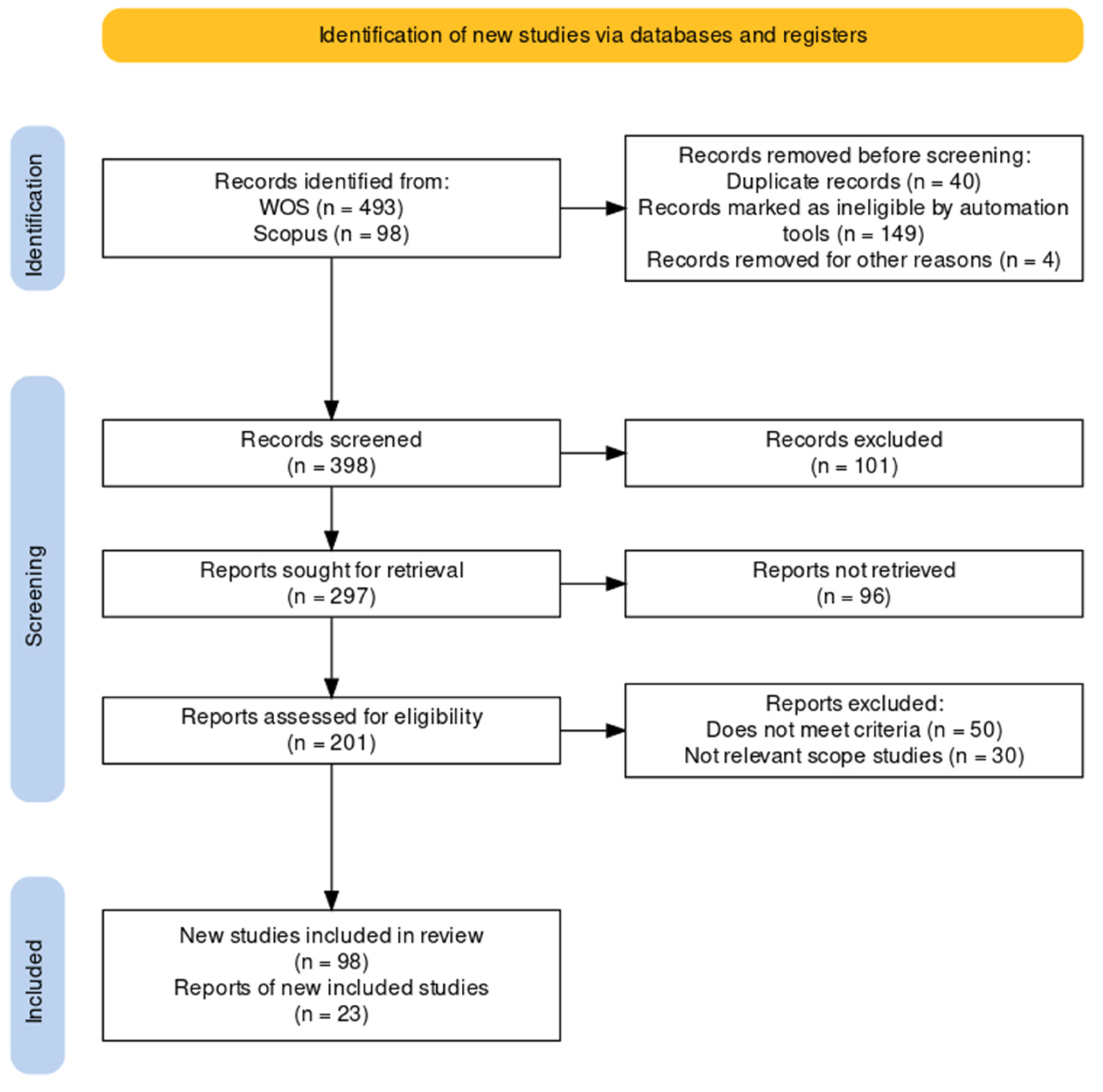
2.1. Literature Review

The PRISMA (Preferred Reporting Items for Systematic Reviews and Meta-Analyses) 2020 statement is a checklist of important things that should be disclosed in a systematic review or meta-analysis. It is an evidence-based reporting guideline [18] that was incorporated into our study. PRISMA 2020 is designed to raise reporting standards, boost transparency, and make it easier to replicate and critically evaluate systematic reviews and meta-analyses. The 27 components in the PRISMA 2020 checklist are broken down into four primary categories: title and abstract, introduction, techniques, and results. Every point is meant to speak to a crucial element of the systematic review or meta-analysis, such as the study question, eligibility requirements, search approach, data extraction, and results synthesis. The PRISMA 2020 statement also contains a four-phase flow graphic that outlines the steps involved in identifying, screening, and determining eligibility, and included studies in the review. The flow diagram provides a visual representation of the number of records identified, screened, and included in the review, as well as the reasons for exclusion at each stage. The PRISMA 2020 framework emphasizes the importance of clear and concise reporting of the study objectives, methods, and results. By following the guidelines outlined in the PRISMA 2020 statement, researchers can ensure that their systematic reviews and meta-analyses are conducted in a transparent and reproducible manner, thereby enhancing the quality and credibility of their research.

2.2. Identification Strategy

The process of identifying relevant studies via databases and registers is a crucial step in conducting a systematic review. In this study (Figure 1), two widely used databases, Web of Science (WOS) and Scopus, were used to identify studies related to the use of UAV aircraft, remote sensing, and Unmanned Aerial Vehicles (UAVs) in urban planning from the year 2016 to 2023. They included full-text articles, academic journals, and conference papers in their search strategy. The search resulted in a total of 591 records, with 493 records identified from WOS and 98 records from Scopus. The team then removed 40 duplicate records that appeared in both databases, bringing the total number of records down to 551. Additionally, 149 records were marked as ineligible by automation tools, which could be software programs designed to identify irrelevant or duplicate records. This step helps to reduce the workload of the research team in screening irrelevant records manually. Finally, the team removed four records for other reasons; these records were conference abstracts or were not available in English. These steps helped the research team to focus on relevant studies that met the inclusion criteria for their systematic review, which would allow them to produce a high-quality and comprehensive review. After these initial exclusions, the research team was left with 398 records for further screening and analysis. Between the years 2016 and 2023, the research team narrowed down their search to focus on studies related to aerial mapping, boundary assessment, archaeology, green space, environmental monitoring, master plan site inspection, and 3D modeling. In total, 398 records were screened for eligibility. Out of these, 101 records were excluded for various reasons. The team then sought to retrieve reports for the remaining 297 records but were unable to retrieve 96 of them. The team then assessed the eligibility of the remaining 201 reports, out of which 50 were excluded because they did not meet the inclusion criteria, and 30 were not relevant to the scope of the studies. The systematic review included a total of 98 studies that met the eligibility criteria and were included in the review. Of these, 23 studies had corresponding reports that were included in the final analysis.

3. Eyes on the Sky: A Transforming Skyline

3.1. UAV Remote Sensing Perspective of Urban Planning

Remote sensing uses sensors to gather data about an object or phenomenon while avoiding direct physical contact [19,20]. Typically, satellite or aerial imagery is used for this, which can offer helpful information on various variables such as land-use patterns, vegetation coverage, and environmental changes. In disciplines such as geography, environmental science, agriculture, and urban planning, remote sensing is frequently used to gather and evaluate data from vast areas that would be challenging or time-consuming to survey on the ground [21]. New sensors and methods are constantly being created to deliver more precise and detailed data, which is how remote sensing technology continuously improves. Remote sensing was first practiced in the 1840s when aerial photos of towns and landscapes were taken using balloons. In their paper, the authors of [22], describe that aerial photography spread throughout the decades, and the military started utilizing it for surveillance during World War I. After the Soviet Union launched Sputnik 1, the first satellite, in 1957, individuals quickly realized the potential of employing satellites to gather data from orbit.
Since the launch of the first remote sensing satellite for earth’s resources and environmental monitoring, i.e., Landsat-1, in 1972, the data received have been used in various applications, including urban planning [23]. The spectral, spatial, radiometric, and temporal resolutions are the limiting factors to a wide range of applications. Since the launch of Satellite Pour l’Observation de la Terre (SPOT-1) in 1986, with better spatial resolution and stereo capability, it has been possible to enhance applications in areas such as topographical mapping. Since then, many satellites have been launched with better spatial and spectral resolutions, broadening the data’s applications [22]. Acquiring data frequently makes it easier to track changes over time and spot trends and anomalies. Many platforms, such as satellites, aircraft, UAVs, and ground-based sensors, can be used for remote sensing. Each platform has pros and cons depending on the application and preferred resolution. They can be used to monitor natural resources, track changes in how land is used, and identify environmental risks. Remote sensing data are frequently processed using image processing techniques such as classification, augmentation, and analysis to extract useful information from the imagery. Automated data processing and analysis can also be done using machine learning methods. Applications that utilize remote sensing technology may move towards using UAVs that can operate at higher altitudes. These UAVs can be larger and can accommodate more safety and security features. With new sensors and platforms such as UAVs, remote sensing technology has evolved dramatically in recent years, making collecting data from locations more straightforward and affordable [24]. Today, a wide range of applications use remote sensing data, from studying the effects of climate change to monitoring natural catastrophes and mapping land use and vegetation cover.
Advancements in UAV remote sensing have brought many benefits, making them an amazing technology with many advantages over traditional data collection methods [25]. UAVs are highly maneuverable and can access difficult or dangerous areas, allowing for greater flexibility in data collection. They can capture high-resolution imagery, providing more detailed information about the target object or environment. UAV remote sensing can be quickly deployed and provide rapid data collection, useful for time-sensitive applications such as disaster response or monitoring rapidly changing conditions. It can also be more cost-effective than traditional methods, especially for smaller areas. It requires fewer resources and can provide real-time data collection and analysis, allowing immediate decision-making and response [26]. This technology captures data across multiple spectral bands, which can provide insights into different properties of the object or environment being studied. Overall, remote sensing offers a powerful data collection, research, and monitoring tool, with many advantages over traditional methods. They are an outstanding and highly advantageous technology because their improvements keep opening new possibilities for various applications in many sectors [27,28]. A systematic literature review by [29] analyzed 186 articles to evaluate the integration of remote sensing, ecology, and urban planning. The study found that only 12% of the articles fully integrated all three disciplines, with the majority of studies focused on contributing to the knowledge base or monitoring the impacts of policies. The accessibility of scientific findings remains limited; most articles are not open access and proprietary software, and data are frequently used. The study suggests future avenues for science and potential entry points for remote sensing to become a vital tool in urban planning.
Remote sensing has been used in urban areas since the early days of aerial photography. Aerial photographs were used to create maps and plans of cities and later to monitor urban growth and development [30]. Satellite remote sensing has been particularly useful for monitoring urban areas because it can cover large areas quickly and cost-effectively. In recent years, advances in satellite technology have made it possible to collect even more detailed and accurate data, enabling urban planners and policymakers to make more informed decisions about managing and developing cities [29]. Large-scale, high-resolution datasets on urban environments, such as land use and land cover, urban expansion, and developments in the built environment through time, are gathered by satellites [31]. The authors of [32] utilize remote sensing data, including land-cover and imperviousness data from the National Land Cover Database (NLCD) 2001–2016, to investigate urban expansion in the Texas Triangle megaregion. Results reveal decreasing urban expansion trends driven by population and economic growth, with pro-sustainability initiatives by anchor cities and metropolitan planning agencies attributed to the changing trend. The study also uses transportation and socio-demographic data from the Texas Department of Transportation (TxDOT) and the U.S. Census Bureau, respectively. Monitoring substantial urban areas and spotting changes that could be challenging to spot on the ground is made possible significantly by satellite data. Lasers are used in the remote sensing technique known as “LiDAR”, which measures the separation between such a sensor and a target [33]. According to [34], LiDAR data can produce accurate 3D models of urban settings, which benefit disaster management, architecture, and urban planning. There are negative impacts of urban sprawl, such as climate change, energy and water resource depletion, pollution, and loss of wildlife and agricultural land, among others. The author of [35] emphasizes the importance of remote sensing techniques, particularly satellite remote sensing, for effective planning and policy support in monitoring urban growth and minimizing urban sprawl and also outlines various methods for monitoring urban changes and the challenges of urban mapping. The benefits of using remote sensing to monitor urban areas include timely and accurate change detection to develop strategies for minimizing urban poverty and related environmental effects. Due to their high spatial resolution data collection capabilities and ease of deployment to targeted regions of interest, UAVs are increasingly employed in urban applications [36]. UAVs are used for various tasks, including mapping urban infrastructure, checking air quality, and determining the extent of natural catastrophe damage [37]. The classification process uses remote sensing data to identify and classify various forms of land cover or land use in metropolitan areas. Area evaluation entails measuring and quantifying several elements of the urban environment using remote sensing data [38]. Examples of this are assessing the size of buildings, roads, and other infrastructure, as well as the amount of open space and water bodies in an urban region. The distribution of resources and infrastructure in metropolitan areas and the location of regions vulnerable to environmental risks can be understood through area assessment. To identify and map the boundaries between various land-use or land-cover categories in urban settings, border estimation uses remote sensing data. Techniques such as image segmentation can be used to separate an image into segments based on similarities in color, texture, or other properties. Many applications, including urban planning, emergency management, and environmental monitoring, might benefit from border estimation [39]. Recent research has indicated that urban planning necessitates two spatial scales, each with unique remote sensing requirements: the local and strategic scales. The local scale focuses on monitoring specific site planning and identifying objects such as building facades. As explained by the authors in [40], the strategic scale is centered on planning and monitoring overall land use (zoning) in cities, which encompasses various categories of urban land-use functions such as residential, industrial, and commercial areas, but at a larger city block scale. A remote sensing task performed can be categorized into classifications: object-based and pixel-based [41,42], urban analysis [43], land-use/land-cover (LULC) change [44], urbanization monitoring [45], monitoring urban heat island [46], and the societal impacts of using UAVs for urban informal settlements by [47]. Pertaining to urban growth, the authors of [48] use night-time light data to analyze urban growth in the Indian-Gangetic planes, proposing a new method for urban area extraction and using machine learning algorithms to predict future growth. The results suggest a methodology for understanding urban areas at the regional scale. A study by [49] highlights the use of remote sensing and GIS to identify the most suitable sites for urban expansion in Haridwar City, Uttarakhand, by analyzing multiple thematic layers, including land use, slope, elevation, NDVI, and ULD. Urban planning is a multifaceted and intricate process that strives to predict and prepare for future situations. Thus, it must balance the advantages and disadvantages concerning all aspects of the urban system [50].
Gallacher et al. [51] pointed out, UAVs have recently demonstrated their potential for usage in a wide range of activities, many of which take place in urban areas. Applications for monitoring in low-risk urban settings include flights over unpopulated locations such as water bodies or steep hills or flights that involve vertical flying.

3.2. Background of UAVs

A UAV can be either a remotely piloted flying robot or an Unmanned Aerial Vehicle that can fly itself using a predetermined flight plane stored in its onboard processor [52,53]. The First World War contributed to the creation of UAVs. The concept of autonomous aerial vehicles is attributed to the Dayton-Wright Airplane Company, which developed a torpedo that would explode at a predetermined time. The Hewitt-Sperry Automatic Airplane project later created another aerial torpedo, which was designed to deliver explosives to enemy territory [54]. As a result, the first UAVs were created in massive amounts during World War II, and their numbers kept increasing as the Cold War started. Although the military sector was the sole focus of UAV development in the early decades, more recent technological advances in the fields of robotics, image processing, machine learning algorithms, artificial intelligence, and global navigation satellite systems (GNSS), as well as an increase in accessibility due to price reductions and production rates, have expanded the uses of UAVs to civilian (non-military) purposes [55].

3.3. UAV Categories

There are numerous categories that UAVs might fall under depending on their uses: size, weight, number of propellers, aerodynamic flight principles, range, equipment, cameras used, and other factors (Table 1). In activities related to the urban planning industry, rotary-wing and fixed-wing UAVs are the most applied, with the distinction between them being based on variances in their aerodynamic flight principles [56]. Motors that use rotary-wing technology are more commonly used because they are more accessible, simple to operate, provide reasonable camera control, can operate in limited places, and support hover and vertical take-off and landing (VTOL). The rotary-wing UAVs can be further divided into tri-copters, quadcopters, and hexacopters, depending on the rotor configurations. However, in their study on rotary-wing UAVs, González-Jorge et al. [57] stated that the flying times of all these UAVs are constrained to no more than 30 min, and they have a small payload capacity (mostly below 8 kg; USI). Fixed-wing UAVs, on the other hand, have a long endurance and can cover a large area quickly. In this instance, the costs associated with the equipment, the amount of space needed for take-off and landing, and the difficulty of flying—which necessitates sufficient training—are the restraints [58]. Hybrid UAVs, which combine the advantages of fixed-wing UAVs with the capacity to hover and take off and land vertically, have also begun to enter the UAV markets more recently [59]. Irrespective of the UAV’s category, its key components and subsystems include the frame, propeller, brushless motors, motor mount, landing gear, flight controller, batteries, payload (which could be a remote sensing camera, spraying system, or applications that pertain to logistics), and sensors [60].
UAVs of the quadcopter/multirotor and fixed-wing varieties have distinctive design elements and flight characteristics (Figure 2). As the name implies, quadcopter/multirotor UAVs contain several rotors, typically four or more, placed symmetrically. The flight controller controls the electric motors that usually power the rotors. Quadcopters are incredibly agile and can fly in any direction, hover in place, and engage in aerial tricks. They are frequently used for leisure activities, including racing and freestyle flying, aerial photography, and filming. On the other hand, fixed-wing UAVs have a solid, fixed wing that produces lift and enables the UAV to fly ahead. They have a propeller to help them go ahead and are propelled by a motor. Fixed-wing UAVs can travel great distances quickly and are built for more extended flight periods. They are frequently used for military and search and rescue operations and other applications such as monitoring, mapping, and surveying. Based on their capabilities, both types of UAVs are utilized for various applications, each with unique advantages and limitations [61].
Yunus et al. [62] clarified several interdependent parts that allow for autonomous flight and precise control (Figure 3). The frame serves as the supporting structure for the rest of the machine. UAVs rely on motors, which are electric motors that turn the UAV’s propellers. Aerodynamic lift is created by rotating the propeller’s blades, which also steer the aircraft. A UAV’s flight path is determined by its flight controller, a miniature computer that receives data from the UAV’s sensors. The UAV’s sensors include an accelerometer, a gyroscope, a barometer, and a Global Positioning System (GPS). The lithium polymer (LiPo) battery can be recharged and supplies energy for electronics and motors. An optional extra, a camera records high-altitude video and stills. The pilot’s ability to direct the UAV’s flight and actions is realized through a transmitter. These parts cooperate to ensure the UAV can take off, fly, and land without incident and gather helpful information or images [62,63].

3.4. UAV Data

Aerial images and 3D point clouds are the two main datum types that UAVs gather for remote sensing and analytic applications. With advancements in UAV technology, 2D aerial imagery acquired via UAV is becoming increasingly accessible and cost-effective, making it a popular tool for various industries and applications [64]. In addition, Latha et al. [65] referred 2D aerial imagery taken by UAVs to two-dimensional (2D) images of the earth’s surface acquired using UAVs. The images captured by these UAVs can give valuable data and insights for various industries, including agriculture, construction, real estate, and environmental monitoring. Using cameras mounted to UAVs, 2D aerial imagery may be taken from multiple angles and heights, offering a full view of the target area. The images are then processed to provide a versatile 2D aerial map or ortho photo. As they offer a precise perspective of the landscape and features, these photos are frequently utilized for mapping, surveying, and monitoring reasons [66]. The author of [67] defines 3D aerial imagery captured by UAVs as aerial photos taken by UAVs that offer a three-dimensional (3D) representation of the earth’s surface. This type of imagery is capable of providing a more detailed view of a location compared to 2D aerial imaging, enabling more precise measurements and analysis (Figure 4). UAVs can take 3D airborne images utilizing various techniques, such as photogrammetry and LiDAR technology [66]. On the other hand, LiDAR technology uses laser sensors to produce a 3D point cloud that may be utilized to build a 3D model. Applications for 3D airborne imaging include geological surveys, monitoring of building sites, and urban planning [68]. It can also be used to create 3D models and maps of structures, infrastructure, and other things and to visualize and analyze topography, such as mountains and valleys. UAV technological advancements have made recording 3D aerial imagery of a particular location more accessible and more affordable than ever, making it a method many businesses utilize.

3.5. UAV-as-a-Service Sector

Researchers have been studying UAVs’ advantages through other remote sensing methods since the early 2000s. Their findings support the conclusion that UAVs are superior because of their high-resolution imagery, accessibility, ease of functionality, applicability in confined spaces, and frequency of operations. Furthermore, all the required tasks could be carried out without compromising the safety of anyone involved [69]. The development of robotic systems, artificial intelligence, data science, and software engineering has facilitated machine learning of flights and workflows associated with data analysis. This includes the implementation of different algorithms for machine learning and classification techniques, as well as the faster processing of software. These advancements have greatly benefited the UAV industry. As a result, when UAVs first appeared on the market, businesses were eager to take advantage of their advantages and frequently decided to replace expensive LiDAR data and low-resolution satellite data with the “newly discovered panacea”. The Federal Aviation Administration (FAA) has become more lenient concerning UAV regulations in the United States, which is one factor in expanding commercial UAVs. As noted by the author of [70], the dominant position of Chinese company Da-Jiang Innovations (DJI) in the consumer-UAV market is an important factor that affects jockeying start-ups in the UAV market. However, the commercial UAV market has changed significantly in recent years, and we have seen a shift in the primary focus from UAV services and software solutions to UAV services and robotics research, which was previously focused on hardware components and robotics research [71]. This heralds the beginning of the drone-as-a-service industry and says a lot about the usefulness of the data collected by UAVs (Figure 5).
Companies specializing in UAV operations, such as Measure and Cyberhawk in the United States, Hemav in Spain, and Aonic in Malaysia, focus on areas such as inspection, mapping, and surveying that are essential for urban planning. These companies aim to provide services that revolutionize the way decision-makers handle their organizations’ time, energy, efficiency, and safety needs [72]. Moreover, the UAV industry has been successful in generating job opportunities for tens of thousands of people within a short span of time and is expected to maintain its dominance in the years ahead. A recent study by the Association for Unmanned Vehicle Systems International (AUVSI) attests to this fact [73], which revealed that the UAV industry is predicted to generate more than 100,000 jobs in the United States alone over the next ten years, contributing USD 13.7 billion to the country’s economy. The author of [74] highlights a major concern arising from the greater automation and adaptability of machines, which is the replacement of human jobs. This is especially worrying for those in the unskilled labor sector.

3.6. Applications of UAVs

UAV use has increased dramatically over the past few years, expanding into new arenas and gaining momentum regularly. Lutkevich et al. [75] emphasized that UAVs are becoming increasingly important to our daily lives as they open new avenues for advancement in various fields. Precision agriculture, forestry, construction, survey, disaster relief, humanitarian aid, anti-poaching, security and surveillance, and education are just a few of these applications’ most important use cases. Farmers can determine environmental indicators such as the Normalized Difference Vegetation Index (NDVI) using multi-spectral cameras mounted on UAVs [76]. Recently, UAVs have also been used for planting trees, and it was discovered that the rate at which they planted trees was ten times faster than that of human labor. This not only enables us to save time but also provides an alternative that can be used to combat deforestation more practically [77]. Apvrille et al. [78] analyzed whether UAVs could be useful in the aftermath of natural disasters and proclaimed the potential of UAVs for use in tasks related to safety and security verification.
To push the boundaries of remote sensing research, UAVs have been modified to acquire LiDAR and Synthetic Aperture Radar (SAR) data [79]. Wallace et al. [80] produced 3D point clouds using a low-cost UAV-LiDAR framework and reported improved spatial accuracy when conducting forest inventory operations. Another study, led by [81], compared this same spatial accuracy of a UAV-LiDAR system compared to Structure from Motion (SfM) remote sensing data and found that UAV-LiDAR offers advantages over SfM photogrammetry for estimating vegetation height and surface elevation. UAV technology is continuously developing and improving in ground-breaking ways, and it has become an essential part of how many businesses and governmental organizations operate. Their applications are anticipated to increase tenfold in the upcoming decades as they cut through sectors that are either static or falling behind [82]. Table 2 shows a classification of UAVs in urban applications based on their typical features and use.

3.7. Policies, Rules, Regulations, and Limitations

A significant hurdle to commercial UAV industries was and is still the regulation and policies associated with UAV flying that are put forward by each country or continent’s aviation administration systems. The rules are very lenient in some countries, such as Sweden and Norway. They have enacted relatively unrestricted legislation on commercial UAV use, whereas in countries in East Asia such as Thailand and South Korea, a visual line of sight is required, thus limiting their potential range. Meanwhile, in certain countries such as India and Chile, there still exists an effective ban on the commercial use of UAVs [83]. In Malaysia, a private pilot’s license and an operating permit are needed to fly commercial UAVs that weigh more than 20 kg. The use of aerial mapping is sometimes limited, particularly from a precision agriculture standpoint, because carrying some UAV types, such as those with multiple sensors, is prohibited in some nations. These sensors are regarded as a possible threat to national security. Unfortunately, these disparate regulations and the absence of unified guidelines for using UAVs have hindered opportunities for the exchange and mobility of research in several instances [84].
UAVs are becoming increasingly popular in various industries, including agriculture, construction, surveying, and aerial photography. However, due to their potential impact on the environment, there are some environmental restrictions that apply to their use. Weather UAVs are not built to function in severe weather conditions because such conditions may negatively affect their performance and safety. According to Thibbotuwawa et al. [85], in heavy rain, water could damage the UAV’s electronics and engines, making it prone to malfunction or even a crash. Strong winds may cause the UAV to become unstable and challenging to handle, increasing the risk of accidents. Additionally, high humidity and cold weather may obstruct the UAV’s sensors and cameras, making it difficult to fly and navigate. As per the information presented in [86], it is crucial to verify the weather forecast before flying a UAV to ensure that the operation is safe and effective. If there is a possibility of adverse weather conditions, it is best to avoid operating the UAV entirely or hold off until the conditions improve. Additionally, UAV pilots must know the restrictions and specifications of their UAV, including the manufacturer’s instructions concerning weather conditions. Many areas are designated as protected under national or international laws to conserve wildlife, ecosystems, and cultural heritage sites. UAVs may not be permitted to fly in these areas or may require special permits to do so. Lopez et al. [87], in their study, stated that the use of small UAVs is increasing, but their impact on local fauna has not been systematically evaluated. The authors reviewed existing literature and conducted a pooled analysis, finding that wildlife reactions depend on the attributes of the UAV and the characteristics of the animal. They suggest guidelines to minimize the impact of UAVs on wildlife and proposed that a legal framework needs to be adopted to protect wildlife from negative effects. Duffy et al. [88] indicated that multi-rotors can create more noise pollution than fixed-wing UAVs since they have more rotors and engines, and therefore can cause disturbance to wildlife, which may undermine the purpose of a survey. As the author of CASA et al. [89] points out, there are typically few regulations in place for flying UAVs for recreational or experimental purposes, and in many cases, a pilot’s license is not needed. However, it is important to recognize that the regulations for recreational or experimental UAV use differ significantly from those for commercial UAV use. There are some legal requirements that apply to UAV usage regardless of the purpose or country, such as not flying near airports, government buildings, or monuments; maintaining a line of sight; following height restrictions; and obtaining the necessary licenses and certifications for the pilot. These regulations exist to ensure the safety, security, and privacy of individuals. The allowable proximity to the no-fly zones can vary depending on failure to adhere to the rules, and the requirements for the permit can result in significant financial penalties for the civilian offender. Nevertheless, this obstacle that UAV users must overcome has been a boon to many software companies.
Various mobile applications have been created in this regard to assist UAV users in identifying airspace areas and avoiding non-designated zones. These applications are intended to guide UAV users in these activities [90]. There are several mobile apps available that display UAV-flying zones and policies and regulations related to UAV usage (Figure 6), and these apps are designed to help UAV pilots fly safely and legally within the regulations and policies set forth by governing authorities.
The process of obtaining permits can be time-consuming and may limit the flexibility of UAV operators. In Malaysia, the use of UAVs is regulated by the Civil Aviation Authority of Malaysia (CAAM). According to [90], operators must obtain permits and follow strict guidelines to ensure the safe and responsible use of UAVs. UAV operators in Malaysia must obtain a Permit to Fly from CAAM. The permit specifies the type of UAV, the pilot’s qualifications, and the purpose of the flight. All UAVs weighing more than 20 kg must be registered with CAAM. Operators must provide the UAV’s specifications, serial number, and other information to register the UAV. There are several no-fly zones in Malaysia where UAVs are prohibited. These include airports, military bases, and other sensitive areas. UAVs must not fly higher than 400 feet (121.92 m) above ground level and must maintain a distance of at least 50 m from people, vehicles, and buildings. UAV operators in Malaysia must have liability insurance to cover any damage or injury that may occur during UAV flights. Night flights are prohibited for UAVs in Malaysia unless the operator obtains special permission from CAAM. Operators using drones for commercial purposes must obtain a special permit from CAAM, and the UAV must meet specific requirements for commercial operations. It is critical to understand that the rules and regulations governing UAV usage in Malaysia are subject to change. It is equally necessary to ensure that one is constantly updated on any modifications or updates to the rules and standards [90]. In addition, the individuals who operate UAVs must ensure that they comply with all applicable legislation and applicable guidelines. The following table (Table 3) provides a summary of the current regulations that apply to UAVs in Malaysia:
Another limitation is the cost associated with high-profile UAVs, mostly fixed-wing, and the processing and analyzing expenses attached to the data analysis procedures. A commercial UAV’s usefulness level is measured by the satisfaction obtained after extracting needed information from the data collected. For that, understanding flight plan settings and values for parameters used while applying an algorithm is important; for example, even when using a UAV for mapping and modeling a study site and taking a colossal number of pictures, if the minimum overlap is very low, then the algorithm cannot build 3D models from it. Since there is not yet an anyone-for-all methodology or parameter threshold that can be applied to UAV data, finding ways to optimize flight and UAV configurations, determining parameter values, and algorithm selection can be demanding for amateur UAV users [91]. External factors such as wind, rain, and level of sunlight may also present additional challenges, affecting the accuracy of the data gathered. The lack of sophisticated hardware in several available UAVs also limits their usage; UAVs that do not feature obstacle detection and collision avoidance features run a high risk of getting damaged fast [92]. However, in the case of fixed-wing UAVs, it is still complicated for an inexperienced operator to pilot the aircraft safely, as noted by Dollesh et al. [93]. When a UAV flies beyond a certain height (or radius) or the battery level drops, it can lose control; this is especially true for rotor-wing UAVs, which have a short battery life and are unsuitable for large-scale studies [58].

4. UAVs for Urban Planning and Development

4.1. Urban Planning and Development

4.1.1. Specifications of Urban Planning

Urban development can also be seen as a gauge of societal growth. One of the most important sociological concerns facing societies today is planning and managing current development. To properly carry out the urban development process and maintain a sustainable environment for future generations, this must be accompanied by a sustainability concept. Urban planning is a complex process that involves both technical and political aspects. It encompasses activities related to land development, environmental protection, public welfare, and the design of the urban environment, including air and water quality, as well as infrastructure such as transportation, communication, and distribution networks that enter and exit the urban area. While constructing a desirable urban environment, designing, and planning neighborhoods and residential areas is a huge task. The difficulty is founded on the concepts of an integrated response to several needs, including social, architectural, aesthetic, economic, sanitary, and hygienic needs [94].
According to [95], urban planning and development are complex processes involving many factors. Land use is the most important factor to be considered in urban planning. Proper zoning and land-use planning are essential to ensure that urban areas are organized to meet the needs of residents, businesses, and the environment. Infrastructure is a key factor in urban planning, which includes transportation systems, water and sewage systems, power supply, waste management, communication systems, and other public utilities. Sustainable urban development aims to satisfy existing needs while maintaining the capacity of future generations to meet their own. This can be achieved by implementing green building standards, using renewable energy sources, and reducing carbon emissions. Urban planning must ensure all residents can access primary healthcare, education, and recreation amenities. Urban planning and development should consider safety as one of the top priorities to minimize crime and ensure public safety. According to Al-Ghiyadh et al. [96], urban areas should be designed with safety measures such as street lighting, surveillance cameras, and other safety measures to prevent criminal activities. Community engagement is crucial in urban planning and development. The participation of residents and other stakeholders in the planning process can help ensure that development meets the community’s needs.

4.1.2. Current Needs and Importance

Urban planning is crucial for the development and sustainability of cities, especially in the face of the growing population and increasing demands for resources [97]. This helps to manage cities’ growth by ensuring that urban area expansion is done sustainably and efficiently. Urban planning also includes developing transportation infrastructure, public spaces, and housing that are accessible and affordable for all. Urban planning aids in ensuring that all urban residents share the advantages of urban development equally. Access to high-quality education, healthcare, and other essential services is part of this [98]. Sustainable development can be promoted in urban regions by implementing renewable energy sources, creating green spaces, and offering sustainable transportation options, which can enhance the overall quality of life and reduce carbon emissions [99]. Urban planning helps enhance cities’ resilience to natural disasters and other external shocks and includes developing infrastructure and emergency preparedness plans to help cities quickly recover from disasters [100]. Planning is crucial in coordinating economic activity’s spatial location and distribution in cities and regions.
Planning can help to build consensus and trust among different groups by providing opportunities for dialogue and engagement. Urban planning can assist in ensuring that policies and projects match the needs and ambitions of stakeholders and communities and that residents are given a stake in the growth of their neighborhoods and the nation. The use of UAVs in urban planning and development has become increasingly important in recent years. UAVs can provide valuable data and insights that can help to improve the accuracy, efficiency, and effectiveness of urban planning and development efforts. In a way, urbanization is desirable for human development [101]. Improper urban planning can have significant negative consequences for cities and their residents. As deficient public services and infrastructure can disproportionately harm low-income and marginalized populations, improper urban planning can perpetuate social inequality, which results in slow economic growth and a decline in the standard of living for locals.

4.1.3. Urban Development Assessment

The urban planning process entails several analysis and execution stages. Each step is equally crucial and necessary for the successful and sustainable development of urban areas [102]. The data collection and analysis stages are two of the most crucial parts of the urban development process. In this case, the data acquired should be concise, accurate, and delivered within an acceptable period. In this regard, aerial mapping and 3D modeling are also needed, as they offer the planners an option to describe the overall site in a detailed and up-to-date state [103]. The site survey and data verification are usually conducted during the data collection stage, and UAVs hold great promise for assisting planners with these tasks as they can enhance the efficacy of the overall workflow through automation, rapid processing, low costs, and easy-to-use functionalities [104]. As mentioned by the research of Fainstein et al. [105], field-based surveys and detailed analyses are required components of urban development assessment. They help provide a comprehensive understanding of the physical, social, economic, and environmental characteristics of urban areas, as well as the opportunities and challenges they face [105].
Assessing the sufficiency and accessibility of urban infrastructure and services, such as transportation networks, water and sanitation systems, healthcare facilities, and educational institutions, can be done by field-based surveys and in-depth analysis, as noted by the authors of [106]. These data can be used to pinpoint regions needing social and economic development and create policies and initiatives that support equitable and long-term economic growth. Conventional urban planning techniques frequently rely on limited data and research, which can result in misleading or partial assessments of urban areas’ problems. As a result, planning decisions may not be supported by data and may need to adequately consider the requirements of local populations [107]. Bringing fresh concepts and cutting-edge strategies into traditional urban planning methodologies can be challenging since they might be conservative and risk averse. As a result, planning choices may be made that could be more futuristic and more attentive to new trends and technologies. New methods such as participatory planning, data analytics, and smart city technologies may be useful in urban planning; Stout et al. [108] believed that using remotely sensed satellites and UAV imagery offers the potential to address these limitations and create more effective and sustainable urban environments.

4.2. Applications of UAVs for Urban Areas

UAVs have a wide range of applications in urban areas, including aerial mapping, site inspection and monitoring, boundary assessment and area estimation, and master plan formulation for cities. They can also be used for green space analysis, environmental monitoring, archaeological monument mapping, wildfire prevention, monitoring, and rescue. UAVs equipped with various sensors can provide valuable data for planning and decision-making in urban development. Examples of typical UAVs, sensors, and their uses in urban planning are shown in Table 4.

4.2.1. Aerial Mapping

Recently, many works on remote sensing UAVs have investigated their application in forested and agricultural areas [27,55]. However, collected reviews show the possibility of extending this knowledge to urban studies. This section explains the previous and ongoing research applied in urban and non-urban environments. Researchers have utilized a mini-UAS MK-Okto developed by HiSystems GmbH, which is equipped with either an NEC F30 IS thermal imaging system or a tetracam Mini MCA-4, to demonstrate the effectiveness of computing the Normalized Difference Vegetation Index (NDVI) [109]. Meanwhile, Gini and Pérez et al. [110,111] used a UAV md4-200 equipped with a Pentax Option A40 for RGB photos and a Sigma DP1 modified for Near Infrared (NIR) band acquisition to classify trees based on various vegetation indices. They also used the system to compare aerial and ground measurements. Similar to [112], the study was conducted using a consumer-grade camera mounted on a fixed-wing platform to perform landslide detection and computation of vegetation indices.
In the other section, a remote sensing UAV is also applicable in analyzing and monitoring disasters such as landslides that occur in many urban areas. Laliberte et al. [113] has studied landslide monitoring through a low-cost UAV approach and also described the use of a quadcopter carrying a 12 MPX camera to characterize landslides on road ditches. European National Mapping Agencies (NMAs) are involved in local uses, such as cadastral applications, land management/land consolidation, or disaster monitoring [114]. To an extent that has never been seen before, developers now have access to data obtained through aerial surveys. A researcher can use the mapping and surveying capabilities of the UAV to collect massive amounts of data much more quickly and in a three-dimensional form, adding a new degree of spatial dynamics to the design process [72]. For example, conventional building inspections can be intrusive and time-consuming. However, cameras equipped with thermal imaging technology can assist in diagnosing air leakages in a structure quickly, which can lead to improvements in the building’s energy efficiency [115]. The UAV’s technology allows for the modeling of the airflow between buildings, the influence of the placement of plants, and even the direction of how pedestrians access and walk through the city. With the help of UAV technology, urban planners can continue making adequate living spaces for expanding communities, as well as ensure that a city has the flexibility necessary to adapt to changing circumstances in the future [72].

4.2.2. 3D Modeling of Structures and Terrain

UAVs recently have been widely used in urban studies using object change detection dealing with large rotations in pairs of UAV-based images. The exact research that applies UAV to urban areas can be seen in UAV detailing by [116]. These preliminary efforts can be acknowledged as starting point of integration for this UAV in urban studies. Meanwhile, Gini et al. [117] reported a contribution on a mission in a quite complex urban area of the tropical city of Singapore with a Falcon 8 Octocopter; it was developed by Ascending Technologies GmbH, with an off-the-shelf Sony NEX-5 camera. Kelcey et al. [118], in their novel work, correct the sensor of the Mikrokopter Oktokopter with a mounted mini-MCA of 6 bands. The study utilized a multispectral sensor by Tetracam Inc for an urban planning application. Gruen et al. [119], on the other hand, modeled the Buddhist fortress of Drapham Dzong Bhutan using the Microdrone MD4-200, assembling the structure with satellite images and terrestrial data. There are some studies performed through the combination of Terrestrial Laser Scanners and oblique aerial imagery from a UAV [120] for 3D reconstruction in archaeology and ancient building surveying. Further, Gruen et al. [121] also demonstrated the utilization of high-resolution satellite imagery (GeoEye-1) to generate DTM and its enhancement through UAS imagery to create high-resolution 3D models of human-made structures. This approach was applied to historic buildings in Bhutan. 3D models created using UAVs can be used to create time-lapse videos that show the progression of a construction project over time. This can be useful for project management and documentation purposes, as well as for marketing and promotional purposes [122].
The authors of [123], in their study, proposed that shadow detection can be used to assess the impact of buildings on nearby parks and other public spaces. By simulating the movement of the sun throughout the day, a 3D model can be used to calculate the areas of the shadow cast by buildings, allowing planners to optimize the placement and design of new structures to minimize their impact on public spaces. Rooftops and other tall buildings can have their condition evaluated using 3D models produced by UAVs [104]. By capturing detailed imagery of the surface of these structures, the model can be used to identify areas of damage and to plan maintenance or repair work as needed. Patrucco et al. [124] highlighted that the thermal characteristics of buildings and other designs can be evaluated with the help of 3D models that were generated by UAVs fitted with thermal cameras by identifying the areas of energy loss or heat gain and building up a plan for energy-efficiency upgrades or renovations. While UAVs can capture high-resolution imagery, the accuracy of the resulting 3D models is limited by the quality of the imagery and the processing algorithms used. This can affect the accuracy of measurements such as height, volume, and area. UAVs for 3D modeling are subject to legal and regulatory requirements depending on the country and region. This can include provisions for pilot certification, flight permissions, and data privacy [90,125]. The cost of using UAVs for 3D modeling can be relatively high, including the UAV’s cost, sensors, and software needed for data processing. Although there are some limitations, the technology provides a powerful tool for capturing high-resolution imagery and generating detailed 3D models of terrain and structures. Planners and decision-makers can choose when and how to use technology to accomplish their objectives by being aware of these limits.

4.2.3. Site Inspection and Monitoring

Evaluating and monitoring a physical location or site to learn about its present state, monitor changes through time, and spot possible risks or hazards is known as site inspection and monitoring [126]. This procedure can be carried out manually, with the help of local staff, or automatically, using automated technologies such as remote sensing or IoT sensors. Halder et al. [127] presented a comprehensive review of 269 papers on the use of robots for the inspection and monitoring of the built environment. Nine types of robotic systems and five applications were identified, with UAVs being the most common. Common research areas investigated include autonomous navigation, knowledge extraction, and safety implications. The findings provide insight into recent developments in robotic inspection and monitoring of the built environment. As well as detecting changes in the site’s status and enabling prompt response to any possible problems, it can offer insights into potential risks and hazards. Many methods can accomplish this, including visual inspections, IoT devices, and remote sensing, as noted by [128]. The collected data will be examined to spot any site-specific alterations, trends, or potential problems. Depending on the goal of the monitoring, the results are communicated to stakeholders, which may include governmental organizations, for-profit businesses, or the public. Risk management, site monitoring, and inspection are essential for guaranteeing the integrity and safety of physical facilities, and technological improvements have made these processes simpler and more efficient than ever [129].
Moreover, UAVs can conduct inspections more quickly and efficiently than traditional methods [130]. Real-time data from UAVs enable quick analysis and reaction to any problems or changes at the site. UAVs can be more cost-effective than conventional approaches, particularly for more prominent or complicated locations, because they require less labor and resources [131]. The change detection approach entails analyzing the data collected by successive UAV flights to identify changes at the site and monitor its progression over time. In general, performing site inspections using UAVs (Figure 7) can produce many significant results and products for various applications [132]. The study by [132] in South Korea presents a method for the automatic detection of construction areas using multitemporal images and deep learning. The method enables more effective identification of changes in construction sites than the existing pixel-based change detection. The proposed method is expected to aid in the development of smart construction technology.

4.2.4. Boundary Assessment and Area Estimation

Historically, ground-based surveys or satellite imaging have been used for boundary assessment. However, these techniques have drawbacks, such as the incapability to record small-scale changes in the landscape or the difficulty in precisely establishing the boundaries of properties in highly populated urban areas [133]. UAVs provide high-resolution aerial images that can be used to specifically identify the boundaries of properties and public places, providing a solution to these restrictions. To create digital maps that precisely depict the boundaries of properties and public places, it is possible to employ UAVs to collect detailed aerial photos of a given area. These maps can then assist in making city planning and land usage decisions. The speed and effectiveness of data collection provided by UAVs for border evaluation are one of its main advantages [134]. Large areas can be quickly covered by UAVs, enabling quick data collection that would be challenging or impossible to get using conventional techniques. This is crucial since it can be difficult to access certain regions or gather data on a wide scale in highly populated metropolitan areas. UAVs may also be fitted with specialist sensors such as LiDAR (Light Detection and Ranging) or photogrammetry, which may provide high-resolution elevation models [135]. Even in locations where the landscape is not level, these models can precisely establish the boundaries of private properties and public areas.
Area estimation, which entails calculating the size of a specific property or public space, is another essential element of urban planning. UAVs can be used to guarantee that new construction or development projects comply with municipal zoning restrictions and land-use policies and to make educated judgments about land use and development. UAVs provide high-resolution aerial imagery and other data that can be utilized to precisely estimate the area of a particular property or public space, providing a solution to the issues of area measurement. The speed and effectiveness with which UAVs can gather data make them one of the most practical tools for area estimation. Large areas can be quickly covered by UAVs, enabling quick data collection that would be challenging or impossible to get using conventional techniques. This can be crucial in heavily populated urban settings were getting to specific locations may not be easy. UAVs offer more excellent aerial imagery and better data resolution than traditional satellites, making it possible to spot changes in the landscape more precisely.

4.2.5. Green Space Analysis

Urban green spaces such as parks and gardens can benefit from Unmanned Aerial Vehicles (UAVs) in various ways. UAVs can monitor these areas to detect illegal activities, track wildlife populations, and identify maintenance needs. They can create maps and 3D models for planning and maintenance purposes. Additionally, UAVs aid in inspecting tree health, irrigation systems, and areas that need mowing or pruning. They can also generate educational content such as virtual tours to raise awareness about green space importance and conservation. Geospatial data on urban green spaces are scarce in emerging Indian cities, affecting their development and monitoring. Avtar et al. [136] explored the use of Unmanned Aerial Vehicles (UAVs) to generate spatial data for urban planning. UAVs are cost-effective and provide a suitable resolution for planners, despite regulatory limitations. The study recommends further experimentation to establish a methodology for mapping green spaces and gathering qualitative data to support urban planning and greening efforts. Recent studies by [137] have focused on the correlation between people’s health and the quality and quantity of green spaces in urban areas. To address this, a deep-learning-based solution has been developed to assess the health level and contamination status of urban land. The objective is to provide health institutions with updated maps indicating areas affected by these phenomena, aiding public health initiatives in large cities. The software is open source, and the data used in the experiments are freely available.

4.2.6. Environmental Monitoring

UAVs are increasingly employed for environmental monitoring in urban areas, utilizing sensors to gather high-resolution data with accuracy and speed. They excel in the real-time detection of air pollutants, aiding in identifying areas with high pollution levels for targeted interventions. The research of Son et al. [138] focused on evaluating the use of UAVs and air quality sensors for monitoring air pollutant emissions. The results showcased the ability to map air quality and achieve a ground sample distance of 5 cm for detailed facility examination. The research is expected to yield guidelines for monitoring pollutant-emitting facilities. Additionally, UAVs equipped with cameras and sensors are valuable in assessing water quality in urban waterways, tracking pollution sources, and changes over time. They also contribute to mapping urban vegetation, providing valuable data for assessing benefits such as heat island mitigation and wildlife habitat provision. Moreover, UAVs facilitate thermal imaging to detect heat loss in buildings, identifying energy-saving opportunities. Furthermore, they measure noise levels in urban areas, aiding in understanding and mitigating the negative impacts of noise pollution on public health. The authors of [139] propose a low-cost UAV-based solution utilizing a microphone array to monitor urban noise emissions, demonstrating its effectiveness, cost-efficiency, and minimal invasiveness. The approach enables the rapid creation of noise pollution maps to enhance road infrastructure.

4.2.7. Archaeological Monument Mapping

Site mapping helps archaeologists understand a site’s layout and features. Traditional mapping methods such as ground-based surveying and satellite imagery cannot accurately capture a site’s details. High-resolution 0.5 cm per pixel cameras can be mounted on UAVs [140]. Archaeologists can see features and structures that other mapping methods miss with this level of detail. High-resolution imagery can create detailed maps and 3D models of archaeological sites. Flexibility is another UAV benefit. UAVs can fly low and follow terrain contours to capture imagery from angles and perspectives that other methods cannot. It can capture detailed images of complex or hard-to-reach areas such as cliff faces or steep slopes. Konchi et al. [141] explored the integration of archaeological prospection, 3D reconstruction, and multispectral imagery obtained from UAVs in large-scale archaeological projects. The researchers propose a methodology that combines the Extended Matrix with other open-source tools to merge information from different methods while ensuring transparency, reproducibility, and separation between scientific processes and derived data. The proposed methodology will be implemented in the investigation of Tres Taberna, a Roman site near Rome, using data from a five-year multidisciplinary project. Archaeological site mapping with UAVs is affordable. UAVs can be flown by one person with minimal gear, and they can map large areas faster and cheaper than other methods. Due to their physical contact with the ground, ground-based surveying methods can damage archaeological sites. UAVs do not disturb fragile sites when mapping. However, UAVs must be used responsibly and in accordance with local laws. Before flying a UAV over an archaeological site, operators should get permission from the proper authorities and avoid disturbing the site.

4.2.8. Wildfire Prevention, Monitoring, and Rescue

UAVs are extremely beneficial for preventing, monitoring, and rescuing in urban wildfires due to their ability to collect data efficiently and quickly from the air. They can detect potential fire hazards in urban areas before they start, provide critical information to firefighters during a wildfire, and locate individuals in distress even in smoky conditions, dropping supplies to those in need of assistance. All this information can be transmitted in real-time to emergency responders to help them make informed decisions about responding to the wildfire. The research of Wang et al. [142] focused on the use of UAVs for urban fire monitoring, as traditional methods suffer from blind spots, high costs, and poor real-time performance. UAVs offer more flexibility, easier control, and a larger monitoring space. The study designed a UAV fire detection platform to improve its performance and optimize the positioning algorithm, with experiments demonstrating that the SLADV-Hop algorithm had lower positioning errors than other algorithms. The authors of [143] proposed a platform that utilizes UAVs equipped with AI and computer vision techniques for smoke and fire recognition and detection. These UAVs patrol over potentially threatened areas, analyzing still images or video input from UAV cameras using their onboard processing capabilities. The paper presents various scenarios for using UAVs in forest fire detection. The research of Koolwal et al. [144] focuses on using machine learning to identify efficient flight paths for UAVs and detect wildfires through image classification. The study evaluated three machine learning techniques, finding that the Genetic Algorithm was effective for wildfire monitoring and surveillance path planning for a circular arrangement of 25 locations. The study also explored deep learning using a convolutional neural network for image classification, with transfer learning being found useful for efficient model training. The study suggests that machine learning can detect wildfires using images captured by UAVs in flight, establishing a baseline for this application.

4.2.9. Master Plan Formulation for Cities

Unmanned Aerial Vehicles can be highly advantageous tools for urban master plan survey formulation. Equipped with high-quality cameras and sensors, UAVs can efficiently capture aerial imagery, providing valuable information on existing infrastructure, land-usage patterns, and the built environment. Additionally, UAVs can create accurate topographical maps and 3D models of urban areas, facilitating terrain analysis and future development planning. By integrating data from other sources, such as demographic and economic data, comprehensive master plans can be formulated. Furthermore, UAVs can be utilized for monitoring construction sites and tracking development progress, ensuring compliance with construction schedules and project plans. However, it is important to keep in mind that the use of UAVs for urban master plan survey formulation may be subject to legal regulations and restrictions. Therefore, it is critical to conduct thorough research and comply with all relevant laws and regulations before conducting any UAV surveys or data collection activities. Table 4 provides a comprehensive overview of the UAV models, their corresponding sensors, and the specific applications they can be used for in urban planning.

5. Rising Urbanization and the Need for UAVs in Malaysia

5.1. Malaysia—A Land of Diverse Culture and Contrasting Landscapes

Malaysia is a tropical country located at 3°8′N 101°41′E consisting of 13 states and three federal territories. It is separated by the South China Sea into the similarly sized regions of Peninsular Malaysia and Malaysia Borneo (Sabah and Sarawak state). Malaysia shares a border with Thailand to the north and Indonesia and Singapore to the south. Malaysia is covered by tropical forests with highland and lowland forests, large rivers, and beautiful marine ecosystems. Malaysia is a unique, multicultural society with the largest ethnic group consisting of Malays, followed by Chinese, indigenous, Indian, and other varieties of native races from Peninsular Malaysia and West Malaysia. Malaysia celebrates different festivals throughout the year with connections to different cultures and religious practices, and some of these unique, diverse cultural practices are influenced by colonization, war, and migration [145]. Of the total area of land in Malaysia, (330,080,300 hectares) only 9% consists of built-up areas, and the rest (91%) is underdeveloped or naturally occurring areas such as forest, agriculture, and water bodies. Almost four-fifths of Peninsular Malaysia is covered by rainforest and swamp. Its capital city, Kuala Lumpur, which is one of the most populated and urbanized cities in Asia, is in the central region of the country. The rate of Malaysia’s economic growth is increasing, with a recorded annual growth of 8.2% in 2022, which is the highest growth rate since the year 2000 [146].
The development pressures have been concentrated within the three major urban regions: Kuala Lumpur in the center of the peninsular region, the city of Johor Bharu in the south, and the state of Penang in the north. According to the report from [147], the urban population has increased by 21.4 million over the past 50 years, from 3 million to 24.4 million. This shows a significant indicator of the status of urbanization in Malaysia, which is considered the fastest among other Southeast Asian countries. The majority of Malaysia’s urban development falls into one of two categories: medium-sized greenfield developments or brownfield developments (re-developments of existing townships) by the private sector, such as developers or conglomerates [148]. Rapid development comes with development pressures and issues such as traffic congestion, urban sprawl, pollution, insufficient social facilities, and issues of ever-increasing solid waste and its disposal [149], as well as increasing disparities between people of varying income levels, which in turn results in more contrasting landscapes comprised of rural areas and skyscrapers placed side-by-side.

5.2. Recent Sprawl of Urbanization

According to Siong et al. [150], the foundation of Malaysia’s modern urban system was based on the influence of British colonialism (1786–1957), where basic infrastructure, transportation systems, and facilities were developed to support financial, commercial, and social administrative functions in order to exploit the natural land resources. Malaysia now is urbanizing rapidly and the rate of urbanization in Malaysia had aggressively increased to 75.1 percent in 2020 from 70.9 percent in 2010 and is projected to reach 85 percent in 2040 according to the Fourth National Physical Plan [146]. The extent of urban growth occurs not only within a city’s legal boundaries but has led to a spillover of the population into a city’s peripheries. The urban population of Malaysia has increased from around 74.3 percent in 2015 to 77.2 percent in 2020 and has decreased the percentage of the rural population (Figure 8), which is expected to migrate to urban areas. The 11th Malaysia Plan accelerated growth for better geographical balance.
This growth is expected to continue, as people from rural areas migrate to urban areas due to employment opportunities and better living conditions. At present, the largest city in Malaysia in terms of population is Kuala Lumpur. This urban city is home to around 1.31 million inhabitants and has one of the world’s busiest ports of entry; it is a hub of major transportation and communication, as well as a hub of significant innovation and technology business, and is now deemed one of the top ten cities in Asia [151]. According to statistics released by the Department of Statistics Malaysia [146], some of the states have increased the national urbanization rates, such as Wilayah Persekutuan (Kuala Lumpur), Selangor, Penang, and Malacca, while other states, such as Kedah and Perak, had a significant increase from the year 2000 to 2010. These data might present big challenges for the rapid urbanization of Malaysia, especially in the major cities, as urban sprawl continues to be a problem for achieving inclusive sustainability. Consequently, the trend of urban sprawl has continued to persist in Malaysia’s major metropolitan cities, where most new developments are in the periphery. Urban sprawl occurred due to poor urban planning, and uncontrolled and uncoordinated urban areas. Urban sprawl is considered a stage that takes place after urbanization, where there is excessive development as cities grow vertically and then tend to grow horizontally when they reach a certain limit and expand out from their borders [152]. These developments have implications for socio-economic developments and cultural aspects of cities in Malaysia [153]. Subsequently, the function of planning institutions, development plans, and development visions for economic corridors and the administrative capital might face challenges.
Since urban sprawl has many implications for nations and countries, proper monitoring is required to measure the rate and manage the effects of urban sprawl. Most of the current work relies on traditional methods that rely intensively on field surveys and human power. However, these are very time-consuming, laborious, and expensive, thereby limiting their applicability. GIS and remote sensing are demonstrating a reliable option for studying and monitoring urban sprawl. Remote sensing can provide a spatially consistent dataset that has enormous coverage at different scales with high spatial detail and multitemporal frequency [154]. Previous studies have demonstrated the use of satellite imagery and LiDAR for addressing issues associated with urban planning, and many researchers have extensively used GIS and remote sensing techniques [116,152,155,156]. According to [116], the physical nature of urban areas was difficult to map, as it was affected by a wide range of spectral signatures and the occurrence of mixed pixels in addition to being exposed to an atmospheric effect if captured by an ordinary optical satellite.
In recent years, data from Unmanned Aerial Vehicles (UAVs), which are a part of remote sensing, have been extensively utilized in urban planning studies, including urban sprawl analysis. UAV systems represent new types of remote sensing platforms that are inexpensive, user-friendly, and provide users with multiple options for collecting geospatial data [157]. Therefore, considering the limitations and advantages of UAV, UAV remote sensing has been identified as being potentially useful for providing the urban planner and analyst with crucial data for urban analysis.

5.3. Advancements in UAV Applications

There are various ongoing applications of UAVs and advancements in the field in Malaysia (Figure 9) [158]. In Malaysia, the usage of UAVs for site inspections, tracking the progress of construction projects, and safety checks is on the rise. UAVs can record high-definition pictures and videos of construction sites, enabling project managers to keep track of developments and spot potential problems [159]. UAVs with thermal imaging cameras not only aid rescue workers in finding those still alive in the rubble but also provide immediate feedback on the scope of the disaster [160]. UAVs with specific sensors can monitor environmental conditions in real time, allowing for a more accurate assessment of where human intervention is needed. New and novel UAV technologies, such as UAVs with artificial intelligence and machine learning capabilities, are now in development in Malaysia. Efforts are also being made to create standards and guidelines for the appropriate and safe usage of UAVs across industries.

5.4. UAVs for Urban Planning in Malaysia

The use of UAVs for urban planning in Malaysia is becoming increasingly popular due to their numerous benefits [163]. Abdullah and Noor et al. [164,165] conducted a study in Kota Bharu, Malaysia, using a DJI Phantom 3 UAV for aerial mapping and identifying a historical building that was constructed in the area from 1840 onwards and still exists today (Figure 10). The study area around the Big Castle in Kelantan contained several significant historical buildings, demonstrating that the region was one of the original Malay cities in Malaysia. The UAV was used to map the area and create a 3D model within a 500 m radius of the study location. Analysis of the current city pattern, land-use distribution, and building heights showed that traditional Malay city elements were preserved in the area and revealed differences in urban patterns between traditional Malay cities and those influenced by British government planning. Additionally, the pattern and city skyline of the study region, which contains the majority of buildings and cultural assets that should be protected, may be examined from the 3D model. This study provides evidence that UAVs can be useful for collecting aerial mapping data and analyzing urban form and building height in city areas. The integration of Urban Planning, GIS, and 3D modelling was emphasized as a platform for analytical tools and data storage.
In 1956, the First Malaysia Plan put a strong emphasis on rural land development in Malaysia intending to boost the economy in rural areas. During that period, the economic condition of rural communities was significantly lower than that of urban communities. National Rural Physical Planning Policy 2030 objectives are aligned with the Sustainable Development Goals 2030 (SDG 2030) proposed by the United Nations (UN), which aim to equip rural communities with the necessary skills to tackle various challenges, particularly the fast-paced technological advancements of the Fourth Industrial Revolution (IR4.0), while ensuring environmental sustainability. The present method by [62] used to monitor rural–urban development in Malaysia relies on traditional techniques that have certain drawbacks. Therefore, advanced technology consisting of both hardware and software should be explored to assess the use of UAV technology along with appropriate systems such as the Rural Grid System and Characteristics of Rural Malaysia System (CHARMs). This study explores the potential of modern technology, specifically UAV technology and two supporting systems (Rural Grid System and Characteristics of Rural Malaysia System), in monitoring rural–urban development in Malaysia. The goal is to move away from conventional methods and instead focus on real-time progress and resource usage. This monitoring is essential for both government and private decision-making regarding future projects. The Rural Grid System and CHARMs are useful tools for updating rural data and identifying areas that require public facilities, infrastructure, and utilities.
Effective construction management is crucial for the success of any construction project. Progress reports are a key aspect of construction management, and they require visual evidence. However, conventional methods of photographing construction sites using a digital camera have limitations. The work of Yunus and Zainudin et al. [62,166] discussed the potential of Micro UAVs to replace conventional methods and provide better images, videos, and 3D models of construction sites. The Micro UAV can capture the whole view of the building, including high-reach points, and produce reliable data for project estimation. Capturing images and videos by flying around the building under construction can be processed to generate a 3D model. The images and videos can be analyzed to monitor the construction progress and any defects in high-reach points in building structures. The use of Micro UAVs can help track construction progress more efficiently and keep the project on schedule. The building construction can be visualized, and the progress work can be monitored using images taken from both the top and side views. These images can also be used as progress photography in progress documents. Figure 11 displays images taken from the top and side views of the construction building that were taken in the Sri Manjung Specialist Centre building in Perak. The study shows that Micro UAVs have the potential to serve as an alternative means of monitoring the progress of construction projects and can replace traditional methods of capturing images on construction sites. The use of Micro UAVs provides an overall view of the construction site, offering various benefits to site engineers and supervisors for monitoring work progress and documenting the process.
The city’s housing industry in Malaysia is expanding quickly to keep up with the needs of the population. However, the emphasis on profit-driven development has led to a decline in residents’ quality of life. Currently, the housing sector has failed to prioritize an important aspect of empowerment, which is creating more comfortable living spaces both inside and outside the house, providing basic facilities and infrastructure, and emphasizing the convenience of residents and neighborhood relationships. This is crucial for improving the overall quality of life, particularly in urban areas. Malaysia offers a variety of housing options, ranging from townhouses to bungalows, which are differentiated by their size, materials, and prices. The technique of utilizing UAVs for monitoring was employed to collect data on renovated houses in Taman Manis 2, Parit Raja, Batu Pahat. Upon comparing the images captured by the UAV with the initial house plans, it was revealed that 160 out of 336 houses had undergone alterations. Surprisingly, 41 of these renovations were done illegally, resulting in a renovation rate ranging from 40% to 96%. The collected information was analyzed, and it was determined that using UAVs to gather information is highly recommended [162]. This study is expected to assist the Municipal Council in identifying improper and illegal renovations carried out by residents in a residential area. The trend in the percentage of renovated house types is illustrated in Figure 12.
Tree canopy is essential for sustaining life on Earth, and in densely populated urban areas, trees play a critical role in mitigating climate change, promoting economic growth, and maintaining human health. Trees also improve the environment and visual appeal of a place, making society more vibrant. Properly maintained trees offer numerous benefits to cities, including enhancing the quality of living environments, reducing urban heat islands, and decreasing energy consumption for heating and cooling buildings [166]. Hence, urban planners must acknowledge the significance of tree canopy to make informed decisions when incorporating it into their plans. This review aims to illustrate the process of mapping tree canopies in a residential neighborhood using UAV-based GIS technologies [167]. The study by [167] conducted a photogrammetric analysis of the Puncak Iskandar residential neighborhood using a UAV DJI Phantom 4 Pro for data acquisition. The analysis focused on tree mapping and comprised four stages: flight planning, data acquisition, data processing, and analysis of results. They measured planted and non-planted trees and determined their crown sizes to be 11,926.769 m2 and 102,566.473 m2, respectively. The difference in crown sizes between the planted and non-planted trees is significant and could have an impact on the living conditions of residents. The study highlights the capabilities of these technologies in measuring and mapping tree canopies in residential areas and emphasizes the significance of tree planting for future planning. It provides valuable insights for urban planners on the benefits of creating a green, sustainable, and healthy living environment.
To effectively manage roads throughout a country, it is necessary to have geometric data about the roads to aid in decision-making and project management. Typically, this datum is collected by field technical support personnel, such as surveyors and engineers, using conventional survey methods. However, in the interest of safety, a study was conducted to explore mapping urban roads using an Unmanned Aerial Vehicle (UAV) and photogrammetry-based method. The study conducted by [168] focused on identifying the optimal flight and sensor parameters, as well as ground control point (GCP) distribution, to acquire detailed texture information about the road. The UAVs used, with respective focal lengths, are the Phantom 4 and Mavic 2 Pro, and the study was conducted in Shah Alam, Selangor and Taman Wahyu, Kuala Lumpur. The primary output of this photogrammetry-based method is an accurate digital orthophoto model (DOM) and digital elevation model (DEM). The study tested various flight parameters such as focal length effectiveness, image end lap percentage, and Ground Sample Distance (GSD), as well as GCP distribution setup. The study found that the longest focal length of 10.26 mm is suitable for road mapping and that a 70% end lap with 1 cm GSD or 25 m altitude is the optimal parameter. Accuracy was found to increase by 1% when GCPs were well-distributed over the project area, and a pyramid-based network was identified as the optimal GCP network.
As of 2021, the Department of Civil Aviation Malaysia released its report [90]; there were over 10,000 registered UAVs in the country. The report also stated that the usage of UAVs in Malaysia is increasing rapidly and that they are being used for various purposes, including photography, surveying, and inspection. In addition, the Malaysian government has recognized the potential of UAVs and has taken steps to regulate their usage. In 2019, the government introduced new regulations that require all UAVs to be registered and for operators to obtain a permit before using them for commercial purposes. Overall, while there may be few specific statistics on the usage of UAVs in urban planning in Malaysia, the technology is becoming increasingly popular and widely used in the country. Table 5 shows statistics on the usage of UAVs from the year 2016 to 2021 in Malaysia:
The usage of UAVs in Malaysia has increased rapidly over the past few years. It is important to note that these numbers only represent registered UAVs, and many more UAVs may be being used without proper registration. Additionally, these figures do not specify the purposes for which the UAVs are being used. The COVID-19 pandemic may have affected the usage of UAVs in Malaysia in 2020, as restrictions on movement and business operations may have limited their use for specific purposes. The number of UAVs registered in Malaysia has been steadily increasing over the years, from 300 in 2016 to 8000 in 2021. This indicates a growing interest in the use of UAVs in Malaysia. There are many applications of UAVs in Malaysia, ranging from commercial to governmental and even recreational purposes.
In Malaysia, one frequent restriction for urban applications of UAVs is their short flight times. UAVs may face difficulties in urban areas and must fly longer for jobs. Although UAVs may require a significant flight time to cover a large area or event, they are increasingly being used for security and surveillance in urban areas. In urban areas, UAVs scan and monitor infrastructure and construction sites. However, longer flight times would be required to gather thorough data over large areas. Although they could need more time in the air to travel great distances and carry numerous objects, UAVs are being developed for package delivery in urban areas. In metropolitan settings, UAVs are employed for disaster response and search and rescue activities. However, longer flight times may be required to cover large areas and identify survivors in those places. UAV operators in Malaysia have several options available to them to circumvent the issue of limited flying time in urban areas: they can select the appropriate model of UAV that has a longer flight time; they can establish charging stations in urban areas to allow for the rapid recharging of UAV batteries; and they can strategically organize their flights. Creating and designing sensors and cameras is crucial to UAV-based remote sensing. The usage of UAVs and UAVs to address numerous urban concerns will be expanded thanks to their sensor and camera capabilities. High-fidelity sensors are getting smaller and more compact, so UAVs can now carry more cargo types than ever. Choosing the ideal model for each distinct industrial usage can be overwhelming with so many different variants available. When used as remote sensing platforms, Unmanned Aerial Vehicles (UAVs) can be repeatedly deployed to capture high temporal resolution data at very high spatial resolution. Although lightweight multispectral sensors for UAVs are being employed more frequently, multispectral applications using UAVs are documented in the literature less often than applications using visible bands. Hyperspectral, LIDAR, multispectral, thermal infrared, and visual sensors have been used and researched the most for UAV/drone-based remote sensing.

5.5. Future Prospectives

UAVs and other new technologies provide a platform for increasing the social effect of development projects on a larger scale. There is a significant opportunity for organizations to increase the positive impact they have on development by collecting the most accurate data possible from the field, conducting analyses on those data, and using the results of those analyses to inform their decisions regarding the design, implementation, monitoring, and evaluation of projects. This technology can transform how development organizations can help their communities. It could do this by giving these groups the tools they need to improve their operational efficiency, the ability to assess and control risks, the accuracy of the data they gather and analyze, and the cost-effectiveness of their operations [170]. UAVs can significantly impact urban development in Malaysia in the future. The usage of UAVs can assist city planners in making informed decisions and enhance the quality of life for residents because of a quickly developing urban landscape and a fast-expanding population. This article analyzed Malaysia’s potential use of UAVs in urban planning. UAVs with high-resolution cameras and sensors can survey and map urban areas accurately and quickly. This information can inform city-planning decisions, such as where to place new buildings or infrastructure. In Malaysia, the use of UAVs for surveying and mapping has already begun, and the results have been promising. The high-resolution images captured by UAVs can provide city planners with detailed information about the land and its topography, which can be used to make informed decisions about urban development [116]. 3D technology can create interactive visualizations of urban areas, which can be used to simulate and analyze various urban development scenarios. This technology can be used to evaluate the impact of new buildings or infrastructure on the environment, traffic, and other factors, helping city planners to make informed decisions [171]. 3D technology can be used to ensure that sewage water treatment facilities function effectively and that water quality standards are met. UAVs can monitor and inspect various parts of a city, such as bridges, buildings, and power lines. They can quickly provide detailed images and data to city planners, who can use this information to make repairs or improvements. For example, UAVs were being used to inspect the condition of bridges, buildings, and other structures in real time without manual inspection. This can save time and resources and reduce the risk of injury to workers.
With a growing population, traffic congestion is becoming an increasingly severe problem in many cities in Malaysia. UAVs can monitor traffic patterns in real-time, helping city planners make informed decisions about traffic management and congestion reduction. In Malaysia, traffic congestion is a significant issue in many cities, and using UAVs can provide city planners with real-time information about traffic flow and congestion patterns. This information can be used to develop more effective traffic management strategies and improve the overall efficiency of the transportation system [172]. UAVs can be quickly deployed to emergencies, such as fires or natural disasters, to provide real-time images and data to first responders and city planners. In Malaysia, UAVs have the potential to be a valuable tool in emergency response and disaster management, as they can quickly provide information about the affected area and assist in the coordination of rescue efforts [173]. As the population grows, the environment in urban areas is negatively impacted. UAVs can be used to monitor and analyze the environment in urban areas, including elements such as air and water quality, to inform city-planning decisions that promote sustainability. In Malaysia, the use of UAVs for environmental monitoring has the potential to significantly improve the quality of life for citizens and promote sustainable development. For example, UAVs can be used to monitor air quality and identify sources of pollution, which can be used to develop strategies to reduce emissions and improve air quality [174]. UAVs can monitor changes in land use over time, including the expansion of urban areas into rural areas, deforestation, and other land-use changes [175,176,177]. This information can inform urban planning decisions, such as where to locate new infrastructure to minimize the environmental impact.
To ensure that urban areas are developed in such a way as to promote and protect biodiversity, this information can be used to influence decisions concerning the management and conservation of biodiversity. The prospects of UAVs in urban planning in Malaysia are up-and-coming. With the ability to provide real-time, accurate, and detailed information about the city, UAVs have the potential to revolutionize urban planning and greatly improve the quality of life for citizens. The regulation of UAVs in urban areas and privacy concerns are two issues that need to be addressed. Yet, the use of UAVs in urban planning in Malaysia has a promising future because of technological developments and increased applications.

6. Conclusions

With improved data and insights that increase accuracy, efficiency, and effectiveness, UAVs have proven to be incredibly useful in urban planning and development. The analysis emphasizes the growing significance of UAVs in urban planning and the need for appropriate standards and regulations to ensure their safe and effective use. By offering useful information and perspectives, UAVs have the potential to address urbanization challenges in Malaysia, such as traffic congestion and rapid development. To fully realize the potential of UAVs in urban planning, additional study and development are necessary. According to the results of this paper, UAVs have evolved into essential tools for urban planning and should be supported by the appropriate standards and regulations. To effectively address urbanization issues, it is essential to investigate and advance the applications of UAVs in urban planning within the Malaysian context. The findings of this study should be used to guide future research in Malaysia, with a focus on 3D modeling and building identification. The paper also emphasizes the necessity of addressing problems and barriers to guarantee the effective and safe use of UAVs in urban applications. Coordination between government agencies, business stakeholders, and the public is necessary for successful implementation.

Author Contributions

All the authors have made a substantial contribution toward the successful completion of this manuscript. Conceptualization, A.M.M.K. and W.S.W.M.J.; methodology, A.M.M.K. and W.S.W.M.J.; formal analysis, A.M.M.K. and W.S.W.M.J.; investigation, A.M.M.K. and W.S.W.M.J.; resources, A.M.M.K., W.S.W.M.J., M.N.M.S. and S.N.M.S.; data curation, A.M.M.K. and W.S.W.M.J.; writing—original draft preparation, A.M.M.K., W.S.W.M.J. and M.M.; writing—review and editing, A.M.M.K., W.S.W.M.J., M.N.M.S., S.N.M.S. and M.M.; visualization, A.M.M.K. and W.S.W.M.J.; supervision, W.S.W.M.J. and M.N.M.S.; project administration, A.M.M.K.; funding acquisition, W.S.W.M.J. and M.M. All authors have read and agreed to the published version of the manuscript.

Funding

The authors gratefully acknowledge the funding for this research work which was under Fundamental Research Grant Scheme (FRGS), with the grant number FRGS/1/2020/WAB03/UKM/02/1. The APC was funded by Geran Universiti Penyelidikan with grant no: GUP-2021-073, Ganjaran Penerbitan with grant no: GP-K022872 and Tabung Agihan Penyelidikan with grant no: TAP-K022872.

Acknowledgments

The authors wish to convey their appreciation to the Institute of Climate Change at Universiti Kebangsaan Malaysia (UKM), and the Earth Observation Centre, Institute of Climate Change for furnishing all necessary materials, equipment, and additional data. The author would also like to thank all co-authors for proofreading the manuscript.

Conflicts of Interest

The authors declare no conflict of interest.

References

  1. Steuteville, R.; Dover, V.; Dittmar, H.; Low, T.; Crabtree, P.; Burden, D.; Marshall, W.; Thadani, D.; Moule, E.; Talen, E.; et al. 25 Great Ideas of New Urbanism; Public Square: La Mesa, CA, USA, 2018; Available online: https://www.cnu.org/sites/default/files/25-great-ideas-book.pdf (accessed on 18 April 2023).
  2. Abdullah, S.; Abdul Rashid, M.F.; Tahar, K.N.; Osoman, M.A. Tree Crown Mapping Based on Unmanned Aerial Vehicle (UAV) Towards A Green-Sustainable Residential. J. Malays. Inst. Plan. 2021, 19, 97–107. [Google Scholar] [CrossRef]
  3. Esch, T.; Taubenböck, H.; Heldens, W.; Thiel, M.; Wurm, M.; Geiss, C.; Dech, S. Urban Remote Sensing-How Can Earth Observation Support the Sustainable Development of Urban Environments? In Proceedings of the Real CORP Coreference, Vienna, Austria, 18–20 May 2010; pp. 837–847. [Google Scholar]
  4. Ab Rahman, A.A.; Wan Mohd Jaafar, W.S.; Abdul Maulud, K.N.; Noor, N.M.; Mohan, M.; Cardil, A.; Silva, C.A.; Che’Ya, N.N.; Naba, N.I. Applications of Drones in Emerging Economies: A Case Study of Malaysia. In Proceedings of the 2019 6th International Conference on Space Science and Communication IconSpace, Johor Bahru, Malaysia, 28–30 July 2019; pp. 35–40. [Google Scholar]
  5. EPU. Twelfth Malaysia Plan, 2O21–2025 A Prosperous, Inclusive, Sustainable Malaysia; Economic Planning Unit, Prime Minister Department: Putrajaya, Malaysia, 2021.
  6. Castro, M.K.Q.; Agbisit, J.B. The ASEAN—The Road to Sustainable Cities; The ASEAN Secretariat: Jakarta, Indonesia, 2021; pp. 1–56. ISSN 2721-8058. [Google Scholar]
  7. Esch, T.; Heldens, W.; Hirner, A.; Keil, M.; Marconcini, M.; Roth, A.; Zeidler, J.; Dech, S.; Strano, E. Breaking New Ground in Mapping Human Settlements from Space—The Global Urban Footprint. ISPRS J. Photogramm. Remote Sens. 2017, 134, 30–42. [Google Scholar] [CrossRef]
  8. Mohsan, S.A.H.; Othman, N.Q.H.; Li, Y.; Alsharif, M.H.; Khan, M.A. Unmanned Aerial Vehicles (UAVs): Practical Aspects, Applications, Open Challenges, Security Issues, and Future Trends. Intell. Serv. Robot. 2023, 16, 109–137. [Google Scholar] [CrossRef]
  9. Nex, F.; Armenakis, C.; Cramer, M.; Cucci, D.A.; Gerke, M.; Honkavaara, E.; Kukko, A.; Persello, C.; Skaloud, J. UAV in the Advent of the Twenties: Where We Stand and What Is Next. ISPRS J. Photogramm. Remote Sens. 2022, 184, 215–242. [Google Scholar] [CrossRef]
  10. Nor, M.M.; Mohd Noor, N. Integrating Satellite Temporal Analysis for Urban Morphology Study in Melaka. IOP Conf. Ser. Earth Environ. Sci. 2018, 169, 012028. [Google Scholar] [CrossRef]
  11. Hartley, R.J.L.; Leonardo, E.M.; Massam, P.; Watt, M.S.; Estarija, H.J.; Wright, L.; Melia, N.; Pearse, G.D. An Assessment of High-Density UAV Point Clouds for the Measurement of Young Forestry Trials. Remote Sens. 2020, 12, 4039. [Google Scholar] [CrossRef]
  12. Granshaw, S.I. RPV, UAV, UAS, RPAS or Just Drone? Photogramm. Rec. 2018, 33, 160–170. [Google Scholar] [CrossRef]
  13. Zhang, X.; Kusrini, K. Autonomous Long-Range Drone Detection System for Critical Infrastructure Safety. Multimed. Tools Appl. 2021, 80, 23723–23743. [Google Scholar] [CrossRef]
  14. Guo, M.; Zhang, Z.; Liu, H.; Huang, Y. NDSRGAN: A Novel Dense Generative Adversarial Network for Real Aerial Imagery Super-Resolution Reconstruction. Remote Sens. 2022, 14, 1574. [Google Scholar] [CrossRef]
  15. Liang, J.; Gong, J.; Li, W. Applications and Impacts of Google Earth: A Decadal Review (2006–2016). ISPRS J. Photogramm. Remote Sens. 2018, 146, 91–107. [Google Scholar] [CrossRef]
  16. Ngom Vougat, R.R.B.; Chouto, S.; Aoudou Doua, S.; Garabed, R.; Zoli Pagnah, A.; Gonne, B. Using Google EarthTM and Geographical Information System Data as Method to Delineate Sample Domains for an Urban Household Surveys: The Case of Maroua (Far North Region-Cameroon). Int. J. Health Geogr. 2019, 18, 22. [Google Scholar] [CrossRef] [PubMed]
  17. World Bank Tapping the Potential of Drones for Development. Available online: https://www.worldbank.org/en/topic/transport/brief/drones-for-development.print (accessed on 20 February 2023).
  18. Page, M.J.; McKenzie, J.E.; Bossuyt, P.M.; Boutron, I.; Hoffmann, T.C.; Mulrow, C.D.; Shamseer, L.; Tetzlaff, J.M.; Akl, E.A.; Brennan, S.E.; et al. The PRISMA 2020 Statement: An Updated Guideline for Reporting Systematic Reviews. BMJ 2021, 372, n71. [Google Scholar] [CrossRef] [PubMed]
  19. Jawd, S.M.; Almuhana, W.H.Y.; Hussein, H.A. Technologies and Types of Remote Sensors. Adv. Electr. Devices 2021, 6, 15–23. [Google Scholar]
  20. Zhu, W.; Cao, Z.; Luo, P.; Tang, Z.; Zhang, Y.; Hu, M.; He, B. Urban Flood-Related Remote Sensing: Research Trends, Gaps and Opportunities. Remote Sens. 2022, 14, 5505. [Google Scholar] [CrossRef]
  21. Almalki, R.; Khaki, M.; Saco, P.M.; Rodriguez, J.F. Monitoring and Mapping Vegetation Cover Changes in Arid and Semi-Arid Areas Using Remote Sensing Technology: A Review. Remote Sens. 2022, 14, 5143. [Google Scholar] [CrossRef]
  22. Khorram, S.; van der Wiele, C.F.; Koch, F.H.; Nelson, S.A.C.; Potts, M.D. Principles of Applied Remote Sensing; Springer: Cham, Switzerland, 2016; ISBN 978-3-319-22560-9. [Google Scholar]
  23. Wulder, M.A.; Loveland, T.R.; Roy, D.P.; Crawford, C.J.; Masek, J.G.; Woodcock, C.E.; Allen, R.G.; Anderson, M.C.; Belward, A.S.; Cohen, W.B.; et al. Current Status of Landsat Program, Science, and Applications. Remote Sens. Environ. 2019, 225, 127–147. [Google Scholar] [CrossRef]
  24. Gallacher, D. Drone Applications for Environmental Management in Urban Spaces: A Review. Int. J. Sustain. Land Use Urban Plan. 2016, 3, 1–14. [Google Scholar] [CrossRef]
  25. Mohd Jaafar, W.S.W.; Maulud, K.N.A.; Muhmad Kamarulzaman, A.M.; Raihan, A.; Sah, S.M.; Ahmad, A.; Maizah Saad, S.N.; Mohd Azmi, A.T.; Syukri, N.K.A.J.; Khan, W.R. The Influence of Deforestation on Land Surface Temperature-A Case Study of Perak and Kedah, Malaysia. Forests 2020, 11, 670. [Google Scholar] [CrossRef]
  26. Yao, H.; Qin, R.; Chen, X. Unmanned Aerial Vehicle for Remote Sensing Applications—A Review. Remote Sens. 2019, 11, 1443. [Google Scholar] [CrossRef]
  27. Saad, S.N.M.; Maulud, K.N.A.; Jaafar, W.S.W.M.; Kamarulzaman, A.M.M.; Omar, H. Tree Stump Height Estimation Using Canopy Height Model at Tropical Forest in Ulu Jelai Forest Reserve, Pahang, Malaysia. IOP Conf. Ser. Earth Environ. Sci. 2020, 540, 012015. [Google Scholar] [CrossRef]
  28. Saad, S.N.M.; Wan Mohd Jaafar, W.S.; Omar, H.; Abdul Maulud, K.N.; Muhmad Kamarulzaman, A.M.; Adrah, E.; Mohd Ghazali, N.; Mohan, M. Modeling Carbon Emissions of Post-Selective Logging in the Production Forests of Ulu Jelai, Pahang, Malaysia. Remote Sens. 2023, 15, 1016. [Google Scholar] [CrossRef]
  29. Wellmann, T.; Lausch, A.; Andersson, E.; Knapp, S.; Cortinovis, C.; Jache, J.; Scheuer, S.; Kremer, P.; Mascarenhas, A.; Kraemer, R.; et al. Remote Sensing in Urban Planning: Contributions towards Ecologically Sound Policies? Landsc. Urban Plan. 2020, 204, 103921. [Google Scholar] [CrossRef]
  30. Alwedyan, S. Monitoring Urban Growth and Land Use Change Detection with GIS Techniques In Irbid City, Jordan. Int. Rev. Spat. Plan. Sustain. Dev. 2023, 11, 253–275. [Google Scholar] [CrossRef]
  31. Núñez, J.M.; Medina, S.; Ávila, G.; Montejano, J. Satellite Information Classification and Interpretation; Rustamov, R.B., Ed.; IntechOpen: London, UK, 2019; ISBN 978-1-83880-567-8. [Google Scholar]
  32. Guo, J.; Zhang, M. Exploring the Patterns and Drivers of Urban Expansion in the Texas Triangle Megaregion. Land 2021, 10, 1244. [Google Scholar] [CrossRef]
  33. Adrah, E.; Wan Mohd Jaafar, W.S.; Omar, H.; Bajaj, S.; Leite, R.V.; Mazlan, S.M.; Silva, C.A.; Chel Gee Ooi, M.; Mohd Said, M.N.; Abdul Maulud, K.N.; et al. Analyzing Canopy Height Patterns and Environmental Landscape Drivers in Tropical Forests Using NASA’s GEDI Spaceborne LiDAR. Remote Sens. 2022, 14, 3172. [Google Scholar] [CrossRef]
  34. Dong, P.; Chen, Q.; Weng, Q. (Eds.) LiDAR Remote Sensing and Applications; CRC Press: Bloomfield, IN, USA, 2018; ISBN 978-1-4822-4301-7. [Google Scholar]
  35. De Paul, O.V. Remote Sensing: New Applications for Urban Areas. Proc. IEEE 2007, 95, 2267–2268. [Google Scholar] [CrossRef]
  36. Soergel, U. Radar Remote Sensing of Urban Areas; Institute of Photogrammetry and GeoInformation: Hannover, Germany, 2010. [Google Scholar]
  37. Kucharczyk, M.; Hugenholtz, C.H. Remote Sensing of Natural Hazard-Related Disasters with Small Drones: Global Trends, Biases, and Research Opportunities. Remote Sens. Environ. 2021, 264, 112577. [Google Scholar] [CrossRef]
  38. Tan, K.C.; Lim, H.S.; MatJafri, M.Z.; Abdullah, K. Landsat Data to Evaluate Urban Expansion and Determine Land Use/Land Cover Changes in Penang Island, Malaysia. Environ. Earth Sci. 2010, 60, 1509–1521. [Google Scholar] [CrossRef]
  39. Gibril, M.B.A.; Kalantar, B.; Al-Ruzouq, R.; Ueda, N.; Saeidi, V.; Shanableh, A.; Mansor, S.; Shafri, H.Z.M. Mapping Heterogeneous Urban Landscapes from the Fusion of Digital Surface Model and Unmanned Aerial Vehicle-Based Images Using Adaptive Multiscale Image Segmentation and Classification. Remote Sens. 2020, 12, 1081. [Google Scholar] [CrossRef]
  40. Sliuzas, R.; Kuffer, M.; Masser, I. The Spatial and Temporal Nature of Urban Objects. In Remote Sensing and Digital Image Processing; Springer: Berlin/Heidelberg, Germany, 2010; Volume 10, pp. 67–84. [Google Scholar]
  41. Anderson, J.R.; Hardy, E.E.; Roach, J.T.; Witmer, R.E. A Land Use and Land Cover Classification System for Use with Remote Sensor Data; Geological Survey: Alexandria, Egypt, 1976; pp. 1–34. [Google Scholar]
  42. Schöpfer, E.; Lang, S.; Srobl, J. Segmentation and Object-Based Image Analysis. In Remote Sensing of Urban and Suburban Areas; Rashed, T., Jurgens, C., Eds.; Springer Science: London, UK, 2010; Volume 10, pp. 181–192. ISBN 978-1-4020-4371-0. [Google Scholar]
  43. Mohd Noor, N.; Abdullah, A.; Hashim, M. Remote Sensing UAV/Drones and Its Applications for Urban Areas: A Review. IOP Conf. Ser. Earth Environ. Sci. 2018, 169, 012003. [Google Scholar] [CrossRef]
  44. Lin, X.; Xu, M.; Cao, C.; Singh, R.P.; Chen, W.; Ju, H. Land-Use/Land-Cover Changes and Their Influence on the Ecosystem in Chengdu City, China during the Period of 1992–2018. Sustain. Switz. 2018, 10, 3580. [Google Scholar] [CrossRef]
  45. Thapa, R.B.; Murayama, Y. Urban Growth Modeling of Kathmandu Metropolitan Region, Nepal. Comput. Environ. Urban Syst. 2011, 35, 25–34. [Google Scholar] [CrossRef]
  46. Coutts, A.M.; Harris, R.J.; Phan, T.; Livesley, S.J.; Williams, N.S.G.; Tapper, N.J. Thermal Infrared Remote Sensing of Urban Heat: Hotspots, Vegetation, and an Assessment of Techniques for Use in Urban Planning. Remote Sens. Environ. 2016, 186, 637–651. [Google Scholar] [CrossRef]
  47. Gevaert, C.M.; Persello, C.; Sliuzas, R.; Vosselman, G. Monitoring Household Upgrading in Unplanned Settlements with Unmanned Aerial Vehicles. Int. J. Appl. Earth Obs. Geoinf. 2020, 90, 102117. [Google Scholar] [CrossRef]
  48. Maithani, S.; Shankar, H.N. Studying Urban Growth Dynamics in Indo-Gangetic Plain. In Advancements in Urban Environmental Studies: Application of Geospatial Technology and Artificial Intelligence in Urban Studies; Rahman, A., Sen Roy, S., Talukdar, S., Shahfahad, Eds.; Springer: Cham, Switzerland, 2023; pp. 101–111. ISBN 978-3-031-21587-2. [Google Scholar]
  49. Tiwari, A.; Tyagi, D.; Sharma, S.K.; Suresh, M.; Jain, K. Multi-Criteria Decision Analysis for Identifying Potential Sites for Future Urban Development in Haridwar, India. In ICCCE 2018; Kumar, A., Mozar, S., Eds.; Lecture Notes in Electrical Engineering; Springer: Singapore, 2019; Volume 500, pp. 761–777. ISBN 9789811302114. [Google Scholar]
  50. Huxley, M.; Inch, A. Urban Planning. In International Encyclopedia of Human Geography, 2nd ed.; Elsevier: Amsterdam, The Netherlands, 2019; pp. 87–92. ISBN 978-0-08-102295-5. [Google Scholar]
  51. Gallacher, D. Drones to Manage the Urban Environment: Risks, Rewards, Alternatives. J. Unmanned Veh. Syst. 2016, 4, 115–124. [Google Scholar] [CrossRef]
  52. Gonzalez, B. Issue 2 Article 3 1-3-2017 Drones and Privacy in the Golden State; 33 Santa Clara Computer & High Tech. L. J.: Santa Clara, CA, USA, 2017; Volume 33, p. 288. [Google Scholar]
  53. Uddin, M. Drone 101: A Must-Have Guide for Any Drone Enthusiast; Amazon Kindle: Washington, DC, USA, 2020. [Google Scholar]
  54. Palik, M.; Nagy, M. Brief History of UAV Development. Repüléstudományi Közlemények 2019, 31, 155–166. [Google Scholar] [CrossRef]
  55. Kamarulzaman, A.M.M.; Wan Mohd Jaafar, W.S.; Abdul Maulud, K.N.; Saad, S.N.M.; Omar, H.; Mohan, M. Integrated Segmentation Approach with Machine Learning Classifier in Detecting and Mapping Post Selective Logging Impacts Using UAV Imagery. Forests 2022, 13, 48. [Google Scholar] [CrossRef]
  56. Puchalski, R.; Giernacki, W. UAV Fault Detection Methods, State-of-the-Art. Drones 2022, 6, 330. [Google Scholar] [CrossRef]
  57. González-Jorge, H.; Martínez-Sánchez, J.; Bueno, M.; Arias, P. Unmanned Aerial Systems for Civil Applications: A Review. Drones 2017, 1, 2. [Google Scholar] [CrossRef]
  58. Rennie, J. Drone Types_ Multi-Rotor, Fixed-Wing, Single Rotor, Hybrid VTOL. Available online: https://www.auav.com.au/articles/drone-types/ (accessed on 16 February 2023).
  59. Saeed, A.S.; Younes, A.B.; Cai, C.; Cai, G. A Survey of Hybrid Unmanned Aerial Vehicles. Prog. Aerospace Sci. 2018, 98, 91–105. [Google Scholar] [CrossRef]
  60. Singh, N.K.; Muthukrishnan, P.; Sanpini, S. Industrial System Engineering for Drones: A Guide with Best Practices for Designing; Apress: Berkeley, CA, USA, 2019; ISBN 978-1-4842-3533-1. [Google Scholar]
  61. Singhal, G.; Bansod, B.; Mathew, L. Unmanned Aerial Vehicle Classification, Applications and Challenges: A Review. Engineering 2018, 2018, 110601. [Google Scholar] [CrossRef]
  62. Yunus, A.M.; Hamzah, A.H.; Azmi, F.A. Drone Technology as A Modern Tool in Monitoring the Rural-Urban Development. IOP Conf. Ser. Earth Environ. Sci. 2020, 540, 012076. [Google Scholar] [CrossRef]
  63. Nyamuhungu, D. The Design and Manufacture of A VTOL UAV. Master’s Thesis, University of Electronic Science and Technology, Sichuan, China, 2022. [Google Scholar] [CrossRef]
  64. Liao, Y.; Mohammadi, M.E.; Wood, R.L. Deep Learning Classification of 2D Orthomosaic Images and 3D Point Clouds for Post-Event Structural Damage Assessment. Drones 2020, 4, 24. [Google Scholar] [CrossRef]
  65. Preethi Latha, T.; Naga Sundari, K.; Cherukuri, S.; Prasad, M.V.V.S.V. Remote Sensing UAV/Drone Technology as A Tool For Urban Development Measures in APCRDA. Int. Arch. Photogramm. Remote Sens. Spat. Inf. Sci. 2019, XLII-2/W13, 525–529. [Google Scholar] [CrossRef]
  66. Paul, A.; Nayana, P.N.; Shaji, M.P.; Joseph, M.; Lakshmipriya, K.A. UAV Aerial Imagery: Mapping & 3d Modelling. Int. J. Res. Trends Innov. 2022, 7, 656–662. [Google Scholar]
  67. Saifizi, M.; Azani Mustafa, W.; Syahirah Mohammad Radzi, N.; Aminudin Jamlos, M.; Zulkarnain Syed Idrus, S. UAV Based Image Acquisition Data for 3D Model Application. IOP Conf. Ser. Mater. Sci. Eng. 2020, 917, 012074. [Google Scholar] [CrossRef]
  68. Duran, Z.; Ozcan, K.; Atik, M.E. Classification of Photogrammetric and Airborne LiDAR Point Clouds Using Machine Learning Algorithms. Drones 2021, 5, 104. [Google Scholar] [CrossRef]
  69. Mohsan, S.A.H.; Khan, M.A.; Noor, F.; Ullah, I.; Alsharif, M.H. Towards the Unmanned Aerial Vehicles (UAVs): A Comprehensive Review. Drones 2022, 6, 147. [Google Scholar] [CrossRef]
  70. Chin, K.S.H.; Siu, A.C.Y.; Ying, S.Y.K.; Zhang, Y. Da Jiang Innovation, DJI: The Future of Possible. Acad. Asian Bus. Rev. 2017, 3, 83–109. [Google Scholar] [CrossRef]
  71. Zanelii, E.; Bodecker, H. Drone-Market-Analysis-2022–2030; Drone Industry Insights UG: Hamburg, Germany, 2022. [Google Scholar]
  72. Gallagher, K. Drones, and the Future of Urban Planning. Available online: https://www.simulyze.com/blog/drones-and-the-future-of-urban-planning (accessed on 20 February 2023).
  73. Jenkins, D.; Vasigh, B. The Economic Impact of Unmanned Aircraft Systems Integration in The United States. Available online: https://www.auvsi.org/our-impact/economic-report (accessed on 18 April 2023).
  74. Chang, J.-H.; Huynh, P. Asean In Transformation: The Future Of Jobs At Risk Of Automation; International Labour Office Organization: Geneva, Switzerland, 2016; Volume 9, ISBN 978-92-2-130965-9. [Google Scholar]
  75. Lutkevich, B. Drone (UAV). Available online: https://www.techtarget.com/iotagenda/definition/drone?vgnextfmt=print (accessed on 20 February 2023).
  76. Agapiou, A. Vegetation Extraction Using Visible-Bands from Openly Licensed Unmanned Aerial Vehicle Imagery. Drones 2020, 4, 27. [Google Scholar] [CrossRef]
  77. Murray, L. E&T Engineering & Technology; IET Services: Wales, UK, 2022. [Google Scholar]
  78. Apvrille, L.; Roudier, Y.; Tanzi, T.J. Autonomous Drones for Disasters Management: Safety and Security Verifications. In Proceedings of the 2015 1st URSI Atlantic Radio Science Conference (URSI AT-RASC), Gran Canaria, Spain, 18–25 May 2015; pp. 1–2. [Google Scholar]
  79. Engel, M.; Andreas, H.; Eric, S.; Stephan, D.; Peichl, M. Recent Results of a UAV-Based Synthetic Aperture Radar for Remote Sensing Applications. In Proceedings of the 13th European Conference on Synthetic Aperture Radar, Online, 29–31 April 2021. [Google Scholar]
  80. Wallace, L.; Lucieer, A.; Malenovský, Z.; Turner, D.; Vopěnka, P. Assessment of Forest Structure Using Two UAV Techniques: A Comparison of Airborne Laser Scanning and Structure from Motion (SfM) Point Clouds. Forests 2016, 7, 62. [Google Scholar] [CrossRef]
  81. Kucharczyk, M.; Hugenholtz, C.H.; Zou, X. UAV–LiDAR Accuracy in Vegetated Terrain. J. Unmanned Veh. Syst. 2018, 6, 212–234. [Google Scholar] [CrossRef]
  82. Insider Intelligence Future of Drones_ Applications & Uses of Drone Technology in 2021. Available online: https://www.businessinsider.com/drone-technology-uses-applications (accessed on 20 February 2023).
  83. Jones, G.L. The Use Of Armed Drones By Law Enforcement: A Need For Essential Elements In Policy. Bachelor’s Thesis, Oklahoma State University, Stillwater, OK, USA, 2019. [Google Scholar]
  84. Torresan, C.; Berton, A.; Carotenuto, F.; Di Gennaro, S.F.; Gioli, B.; Matese, A.; Miglietta, F.; Vagnoli, C.; Zaldei, A.; Wallace, L. Forestry Applications of UAVs in Europe: A Review. Int. J. Remote Sens. 2017, 38, 2427–2447. [Google Scholar] [CrossRef]
  85. Thibbotuwawa, A.; Bocewicz, G.; Radzki, G.; Nielsen, P.; Banaszak, Z. UAV Mission Planning Resistant to Weather Uncertainty. Sensors 2020, 20, 515. [Google Scholar] [CrossRef]
  86. Gao, M.; Hugenholtz, C.H.; Fox, T.A.; Kucharczyk, M.; Barchyn, T.E.; Nesbit, P.R. Weather Constraints on Global Drone Flyability. Sci. Rep. 2021, 11, 12092. [Google Scholar] [CrossRef]
  87. Jiménez López, J.; Mulero-Pázmány, M. Drones for Conservation in Protected Areas: Present and Future. Drones 2019, 3, 10. [Google Scholar] [CrossRef]
  88. Duffy, J.; Anderson, K.; Shapiro, A.; Avino, F.S.; Glover-Kapfer, P. WWF Conservation Technology, Drone Technologies for Conservation. WWF 2020, 1, 124. [Google Scholar]
  89. CASA Drone Safety Rules for Recreational Drone Operators. Available online: https://www.casa.gov.au/sites/default/files/2021-03/transcript-drone-safety-rules-recreational-drone-operators.pdf (accessed on 8 February 2023).
  90. Civil Aviation Authority of Malaysia. CAAM Report for Standard Requirement for The Application of Drone Permit (Below 20kg); CAAM: UAS–02/2019; Civil Aviation Authority of Malaysia: Kuala Lumpur, Malaysia, 2019.
  91. Mcllrath, L. Drones: Benefits Study High Level Findings. MOT009.18.; Ministry of Transport: Wellington, New Zealand, 2019. Available online: https://www.transport.govt.nz/assets/Uploads/Report/04062019-Drone-Benefit-Study.pdf (accessed on 8 February 2023).
  92. Hristozov, S.; Zlateva, P. Concept Model for Drone Selection in Specific Disaster Conditions. Int. Arch. Photogramm. Remote Sens. Spat. Inf. Sci. 2018, XLII-3/W4, 245–249. [Google Scholar] [CrossRef]
  93. Dolesh, R.J. The Drones Are Coming. Available online: https://www.nrpa.org/parks-recreation-magazine/2015/march/the-drones-are-coming/ (accessed on 21 February 2023).
  94. Leyzerova, A.; Sharovarova, E.; Alekhin, V. Sustainable Strategies of Urban Planning. Procedia Eng. 2016, 150, 2055–2061. [Google Scholar] [CrossRef]
  95. Hassan, M.I.; Elhassan, S.M.M. Modelling of Urban Growth and Planning: A Critical Review. J. Build. Constr. Plan. Res. 2020, 8, 245–262. [Google Scholar] [CrossRef]
  96. Al-Ghiyadh, M.A.-K.; Al-Khafaji, S.J.N. The Role of Urban Planning and Urban Design on Safe Cities. IOP Conf. Ser. Mater. Sci. Eng. 2021, 1058, 012065. [Google Scholar] [CrossRef]
  97. Mouratidis, K. Urban Planning and Quality of Life: A Review of Pathways Linking the Built Environment to Subjective Well-Being. Cities 2021, 115, 1–12. [Google Scholar] [CrossRef]
  98. Hahn, R.A.; Truman, B.I. Education Improves Public Health, and Promotes Health Equity. Int. J. Health Serv. 2015, 45, 657–678. [Google Scholar] [CrossRef]
  99. Pardo, C.F.; Jiemian, Y.; Mohanty, C.R. Chapter 4—Sustainable Urban Transport. In Shanghai Manual—A Guide for Sustainable Urban Development in the 21st Century; United Nations Department of Economic and Social Affairs (UNDESA): Shanghai, China, 2012; pp. 1–38. [Google Scholar]
  100. WHO. Urban Planning for Resilience and Health: Key Messages; World Health Organization: Geneva, Switzerland, 2022; pp. 1–36. [Google Scholar]
  101. Arouri, M.E.H.; Youssef, A.B.; Nguyen-Viet, C.; Soucat, A. 2014. Effects of Urbanization on Economic Growth and Human Capital Formation in Africa. PGDA Working Paper No. 119, Harvard University. Available online: http://www.hsph.harvard.edu/pgda/working.htm (accessed on 18 April 2023).
  102. WEC. Inspiring Future Cities & Urban Services Shaping the Future of Urban Development & Services Initiative; World Economic Forum: Geneva, Switzerland, 2016; pp. 1–60. [Google Scholar]
  103. Biljecki, F.; Stoter, J.; Ledoux, H.; Zlatanova, S.; Çöltekin, A. Applications of 3D City Models: State of the Art Review. ISPRS Int. J. Geo-Inf. 2015, 4, 2842–2889. [Google Scholar] [CrossRef]
  104. Wingtra Drones in Construction and Infrastructure—Why and How to Use Them. Available online: https://wingtra.com/drone-mapping-applications/drones-in-construction-and-infrastructure/ (accessed on 23 February 2023).
  105. Fainstein, S.S. Urban Planning. Available online: https://www.britannica.com/topic/urban-planning (accessed on 8 March 2023).
  106. Drescher, A.W. Technical Tools for Urban Land Use Planning; Technical Report for University of Freiburg; University of Freiburg: Freiburg, Germany, 2001; pp. 1–4. [Google Scholar]
  107. Lurev, A. Role of Data in Urban Planning and Development Case City; Lahti. Bachelor’s Degree Thesis, Lab University of Applied Sciences, Lahti, Finland, 2020. [Google Scholar]
  108. Stout, W.R. Bridging the Geospatial Education-Workforce Divide: A Case Study on How Higher Education Can Address the Emerging Geospatial drivers And Trends Of The Intelligent web Mapping Era. Ph.D. Thesis, Liberty University, Lynchburg, VA, USA, 2022. [Google Scholar]
  109. Bendig, J.; Bolten, A.; Bareth, G. Introducing A Low-Cost Mini-UAV For Thermal- And Multispectral-Imaging. Int. Arch. Photogramm. Remote Sens. Spat. Inf. Sci. 2012, XXXIX-B1, 345–349. [Google Scholar] [CrossRef]
  110. Gini, R.; Passoni, D.; Pinto, L.; Sona, G. Aerial Images from An UAV System: 3d Modeling And Tree Species Classification In A Park Area. Int. Arch. Photogramm. Remote Sens. Spat. Inf. Sci. 2012, XXXIX-B1, 361–366. [Google Scholar] [CrossRef]
  111. Pérez, M.; Agüera, F.; Carvajal, F. Low-Cost Surveying Using an Unmanned Aerial Vehicle. Int. Arch. Photogramm. Remote Sens. Spat. Inf. Sci. 2013, XL-1/W2, 311–315. [Google Scholar] [CrossRef]
  112. Rau, J.Y.; Jhan, J.P.; Lo, C.F.; Lin, Y.S. Landslide Mapping Using Imagery Acquired By A Fixed-Wing UAV. Int. Arch. Photogramm. Remote Sens. Spat. Inf. Sci. 2012, XXXVIII-1/C22, 195–200. [Google Scholar] [CrossRef]
  113. Laliberte, A.S.; Herrick, J.E.; Rango, A.; Winters, C. Acquisition, Orthorectification, and Object-Based Classification of Unmanned Aerial Vehicle (UAV) Imagery for Rangeland Monitoring. Photogramm. Eng. Remote Sens. 2010, 76, 661–672. [Google Scholar] [CrossRef]
  114. Cramer, M.; Bovet, S.; Gültlinger, M.; Honkavaara, E.; McGill, A.; Rijsdijk, M.; Tabor, M.; Tournadre, V. On The Use Of RPAS In National Mapping—The Eurosdr Point Of View. Int. Arch. Photogramm. Remote Sens. Spat. Inf. Sci. 2013, XL-1/W2, 93–99. [Google Scholar] [CrossRef]
  115. Zhang, Y.; Wu, H.; Yang, W. Forests Growth Monitoring Based on Tree Canopy 3D Reconstruction Using UAV Aerial Photogrammetry. Forests 2019, 10, 1052. [Google Scholar] [CrossRef]
  116. Noor, N.M.; Abdullah, A.; Hashim, M. Remote Sensing UAV/Drones and Its Applications for Urban Areas: A Review. In Proceedings of the IOP Conference Series: Earth and Environmental Science; Institute of Physics Publishing: Kuala Lumpur, Malaysia, 2018. [Google Scholar] [CrossRef]
  117. Qin, Y.; Kishk, M.A.; Alouini, M.-S. Stochastic Geometry-Based Analysis of Multi-Purpose UAVs for Package and Data Delivery. Internet Things J. 2023, 10, 4664–4676. [Google Scholar] [CrossRef]
  118. Kelcey, J.; Lucieer, A. Sensor Correction of a 6-Band Multispectral Imaging Sensor for UAV Remote Sensing. Remote Sens. 2012, 4, 1462–1493. [Google Scholar] [CrossRef]
  119. Gruen, A.; Huang, X.; Qin, R.; Du, T.; Fang, W.; Boavida, J.; Oliveira, A. Joint Processing of UAV Imagery And Terrestrial Mobile Mapping System Data For Very High Resolution City Modeling. Int. Arch. Photogramm. Remote Sens. Spat. Inf. Sci. 2013, XL-1/W2, 175–182. [Google Scholar] [CrossRef]
  120. Onwudinjo, K.C.; Smit, J. Estimating the Performance of Multi-Rotor Unmanned Aerial Vehicle Structure-from-Motion (UAVsfm) Imagery in Assessing Homogeneous and Heterogeneous Forest Structures: A Comparison to Airborne and Terrestrial Laser Scanning. South Afr. J. Geomat. 2022, 11, 65–83. [Google Scholar] [CrossRef]
  121. Gruen, A.; Zhang, Z.; Eisenbeiss, H. UAV Photogrammetry in Remote Areas—3d Modeling Of Drapham Dzong Bhutan. Int. Arch. Photogramm. Remote Sens. Spat. Inf. Sci. 2012, XXXIX-B1, 375–379. [Google Scholar] [CrossRef]
  122. Remondino, F.; Barazzetti, L.; Nex, F.; Scaioni, M.; Sarazzi, D. UAV Photogrammetry for Mapping And 3d Modeling—Current Status and Future Perspectives. Int. Arch. Photogramm. Remote Sens. Spat. Inf. Sci. 2012, XXXVIII-1/C22, 25–31. [Google Scholar] [CrossRef]
  123. Arias-Rosales, A.; LeDuc, P.R. Shadow Modeling in Urban Environments for Solar Harvesting Devices with Freely Defined Positions and Orientations. Renew. Sustain. Energy Rev. 2022, 164, 112522. [Google Scholar] [CrossRef]
  124. Patrucco, G.; Giulio Tonolo, F.; Sammartano, G.; Spanò, A. Sfm-Based 3d Reconstruction Of Heritage Assets Using UAV Thermal Images. Int. Arch. Photogramm. Remote Sens. Spat. Inf. Sci. 2022, XLIII-B1-2022, 399–406. [Google Scholar] [CrossRef]
  125. Lee, D.; Hess, D.J.; Heldeweg, M.A. Safety and Privacy Regulations for Unmanned Aerial Vehicles: A Multiple Comparative Analysis. Technol. Soc. 2022, 71, 102079. [Google Scholar] [CrossRef]
  126. Rout, B.K.; Sikdar, B.K. Hazard Identification, Risk Assessment, and Control Measures as an Effective Tool of Occupational Health Assessment of Hazardous Process in an Iron Ore Pelletizing Industry. Indian J. Occup. Environ. Med. 2017, 21, 56–76. [Google Scholar] [CrossRef] [PubMed]
  127. Halder, S.; Afsari, K. Robots in Inspection and Monitoring of Buildings and Infrastructure: A Systematic Review. Appl. Sci. 2023, 13, 2304. [Google Scholar] [CrossRef]
  128. Feroz, S.; Dabous, S.A. Uav-Based Remote Sensing Applications for Bridge Condition Assessment. Remote Sens. 2021, 13, 1809. [Google Scholar] [CrossRef]
  129. Rakha, T.; Gorodetsky, A. Review of Unmanned Aerial System (UAS) Applications in the Built Environment: Towards Automated Building Inspection Procedures Using Drones. Autom. Constr. 2018, 93, 252–264. [Google Scholar] [CrossRef]
  130. Flyability A Guide to How Drones Are Used for Inspections. Available online: https://www.flyability.com/drone-inspections (accessed on 25 February 2023).
  131. Kangunde, V.; Jamisola, R.S.; Theophilus, E.K. A Review on Drones Controlled in Real-Time. Int. J. Dyn. Control 2021, 9, 1832–1846. [Google Scholar] [CrossRef]
  132. Han, D.; Lee, S.B.; Song, M.; Cho, J.S. Change Detection in Unmanned Aerial Vehicle Images for Progress Monitoring of Road Construction. Buildings 2021, 11, 150. [Google Scholar] [CrossRef]
  133. Hu, S.; Tong, L.; Frazier, A.E.; Liu, Y. Urban Boundary Extraction and Sprawl Analysis Using Landsat Images: A Case Study in Wuhan, China. Habitat Int. 2015, 47, 183–195. [Google Scholar] [CrossRef]
  134. Crommelinck, S.; Höfle, B.; Koeva, M.N.; Yang, M.Y.; Vosselman, G. Interactive Cadastral Boundary Delineation from UAV Data. ISPRS Ann. Photogramm. Remote Sens. Spat. Inf. Sci. 2018, IV-2, 81–88. [Google Scholar] [CrossRef]
  135. Zhou, L.; Meng, R.; Tan, Y.; Lv, Z.; Zhao, Y.; Xu, B.; Zhao, F. Comparison of UAV-Based LiDAR and Digital Aerial Photogrammetry for Measuring Crown-Level Canopy Height in the Urban Environment. Urban For. Urban Green. 2022, 69, 127489. [Google Scholar] [CrossRef]
  136. Avtar, R.; Watanabe, T. Unmanned Aerial Vehicle: Applications in Agriculture and Environment; Springer Nature Switzerland AG: Cham, Switzerland, 2020; pp. 1–255. ISBN 978-3-030-27156-5. [Google Scholar]
  137. Moreno-Armendáriz, M.; Calvo, H.; Duchanoy, C.; López-Juárez, A.; Vargas-Monroy, I.; Suarez-Castañon, M. Deep Green Diagnostics: Urban Green Space Analysis Using Deep Learning and Drone Images. Sensors 2019, 19, 5287. [Google Scholar] [CrossRef]
  138. Son, S.W.; Yu, J.J.; Kim, D.W.; Park, H.S.; Yoon, J.H. Applications of Drones for Environmental Monitoring of Pollutant-Emitting Facilities. Proc. Natl. Inst. Ecol. Repub. Korea 2021, 2, 298–304. [Google Scholar] [CrossRef]
  139. Minea, M.; Dumitrescu, C.M. Urban Traffic Noise Analysis Using UAV-Based Array of Microphones. Sensors 2023, 23, 1912. [Google Scholar] [CrossRef]
  140. Themistocleous, K. The Use of UAVs for Cultural Heritage and Archaeology. In Remote Sensing for Archaeology and Cultural Landscapes; Hadjimitsis, D.G., Themistocleous, K., Cuca, B., Agapiou, A., Lysandrou, V., Lasaponara, R., Masini, N., Schreier, G., Eds.; Springer Remote Sensing/Photogrammetry Series; Springer: Cham, Switzerland, 2020; pp. 241–269. ISBN 978-3-030-10978-3. [Google Scholar]
  141. Ronchi, D.; Limongiello, M.; Demetrescu, E.; Ferdani, D. Multispectral UAV Data and GPR Survey for Archeological Anomaly Detection Supporting 3D Reconstruction. Sensors 2023, 23, 2769. [Google Scholar] [CrossRef] [PubMed]
  142. Wang, G.; Cao, Y.; Zhou, J. The Application of Drones in Urban Fire Monitoring. In Proceedings of the Cyber Security Intelligence and Analytics; Xu, Z., Alrabaee, S., Loyola-González, O., Zhang, X., Cahyani, N.D.W., Ab Rahman, N.H., Eds.; Springer: Cham, Switzerland, 2022; pp. 537–544. [Google Scholar]
  143. Kinaneva, D.; Hristov, G.; Raychev, J.; Zahariev, P. Early Forest Fire Detection Using Drones and Artificial Intelligence. In Proceedings of the 2019 42nd International Convention on Information and Communication Technology, Electronics and Microelectronics (MIPRO), Opatija, Croatia, 20–24 May 2019; IEEE: Piscataway, NJ, USA, 2019; pp. 1060–1065. [Google Scholar]
  144. Koolwal, A.; Hussain, A.; Vairavel, A. Exploring Applications of Machine Learning for Wildfire Monitoring and Detection Using Unmanned Aerial Vehicles; Technical Report for National Aeronautics and Space Administration NASA/TM—20220016356; National Aeronautics and Space Administration: Hampton, VA, USA, September 2022. Available online: http://sti.nasa.gov/ (accessed on 18 April 2023).
  145. Blankenship, S.F.; Tan, K.K.H. The Survival of Cultural Patterns in Malaysia’s Contemporary Visual Landscape. In Contemporary Asian Artistic Expressions and Tourism, Perspectives on Asian Tourism; Mura, P., Ed.; Springer Nature: Singapore, 2020; pp. 147–167. [Google Scholar]
  146. DOSM Gross Domestic Product (GDP) By State 2021; Department of Statistics Malaysia: Kuala Lumpur, Malaysia, 2021.
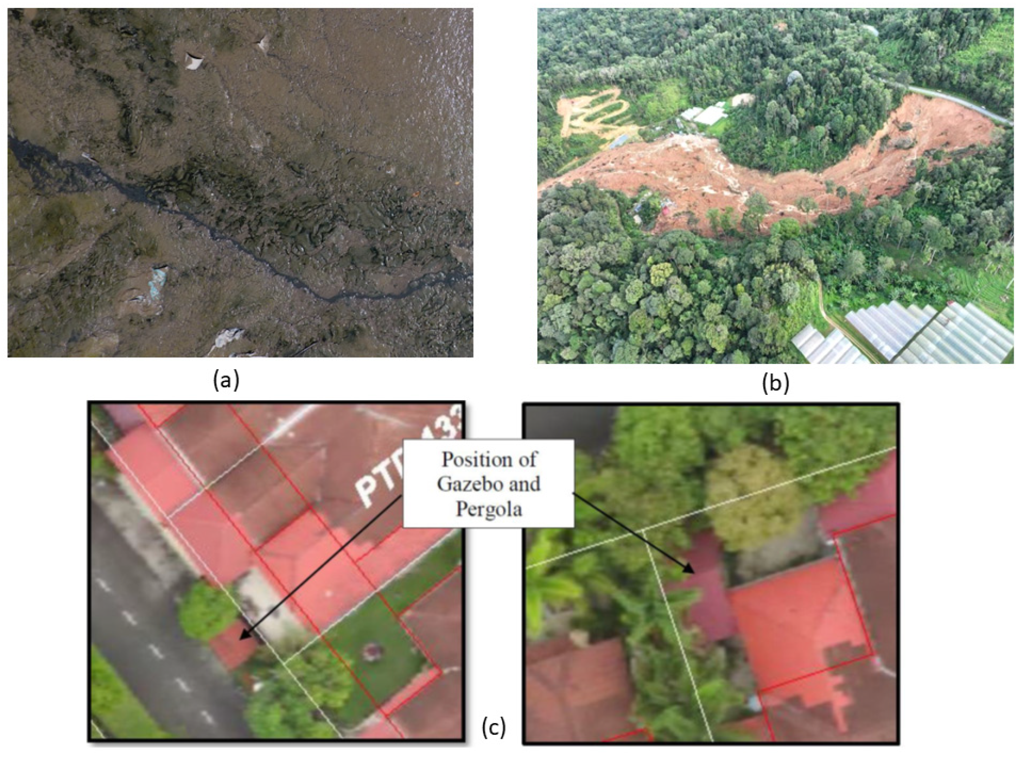
  147. Zolkepli, F.; Camoens, A. Batang Kali Landslide: Search Focusing on Two of Three Zones. Available online: https://www.thestar.com.my/news/nation/2022/12/16/batang-kali-landslide-search-focusing-on-two-of-three-zones (accessed on 13 March 2023).
  148. Seng, C.H. Urbanization in Malaysia and Potential of Social Innovation Business; Hitachi Global Innovation Report: Kuala Lumpur, Malaysia, 2018. [Google Scholar]
  149. Talha, K. Urban Crime and Safe Neighbourhoods: Community Perspectives. J. Malays. Inst. Plan. 2008, 4, 39–55. [Google Scholar]
  150. Siong, H.C. Urban Governance and Rapid Urbanization Issues in Malaysia. J. Alam Bina. 2008, 13, 1–24. [Google Scholar]
  151. Yasin, M.Y.; Zain, M.A.M.; Hassan, M.H. Urbanization and Growth of Greater Kuala Lumpur: Issues and Recommendations for Urban Growth Management. Southeast Asia Multidiscip. J. 2022, 22, 4–19. [Google Scholar]
  152. Rosni, N.A.; Mohd Noor, N.; Abdullah, A. Managing Urbanisation and Urban Sprawl in Malaysia by Using Remote Sensing and GIS Applications. J. Malays. Inst. Plan. 2016, 4, 17–30. [Google Scholar] [CrossRef]
  153. Abdullah, J. City Competitiveness and Urban Sprawl: Their Implications to Socio-Economic and Cultural Life in Malaysian Cities. Procedia—Soc. Behav. Sci. 2012, 50, 20–29. [Google Scholar] [CrossRef]
  154. Boori, M.S.; Netzband, M.; Choudhary, K.; Voženílek, V. Monitoring and Modeling of Urban Sprawl through Remote Sensing and GIS in Kuala Lumpur, Malaysia. Ecol. Process. 2015, 4, 1–10. [Google Scholar] [CrossRef]
  155. Krishnaveni, K.S.; Anilkumar, P.P. Managing Urban Sprawl Using Remote Sensing and GIS. In Proceedings of the International Archives of the Photogrammetry, Remote Sensing and Spatial Information Sciences; ISPRS Archives: Baltimore, MD, USA, 2019; pp. 59–66. [Google Scholar]
  156. Sridhar, M.B.; Sathyanathan, R.; Subramani, R.; Sudalaimathu, K. Urban Sprawl Analysis Using Remote Sensing Data and Its Impact on Surface Water Bodies: Case Study of Surat, India. In Proceedings of the IOP Conference Series: Materials Science and Engineering; IOP Publishing: Bristol, UK, 2020; pp. 1–12. [Google Scholar] [CrossRef]
  157. Mohd Noor, N.; Abdullah, A.A.A.; Abdullah, A.; Ibrahim, I.; Sabeek, S. 3D City Modeling Using Multirotor Drone for City Heritage Conservation. Plan. Malays. J. 2019, 17. [Google Scholar] [CrossRef]
  158. Gohari, A.; Ahmad, A.B.; Oloruntobi, O.O. Recent Drone Applications in Malaysia: An Overview. Int. Arch. Photogramm. Remote Sens. Spat. Inf. Sci. 2023, XLVIII-4/W6-2022, 131–137. [Google Scholar] [CrossRef]
  159. Omar, M.R.; Masrom, A.N.; Mohamed, S.; Ahamad, J. Reviewing Challenges of Drone Technology Application Amongst Contractor G7. Res. Manag. Technol. Bus. 2022, 3, 599–611. [Google Scholar]
  160. Daud, S.M.S.M.; Yusof, M.Y.P.M.; Heo, C.C.; Khoo, L.S.; Singh, M.K.C.; Mahmood, M.S.; Nawawi, H. Applications of Drone in Disaster Management: A Scoping Review. Sci. Justice 2022, 62, 30–42. [Google Scholar] [CrossRef] [PubMed]
  161. Geraeds, M.; van Emmerik, T.; de Vries, R.; bin Ab Razak, M.S. Riverine Plastic Litter Monitoring Using Unmanned Aerial Vehicles (UAVs). Remote Sens. 2019, 11, 2045. [Google Scholar] [CrossRef]
  162. Mustaffa, A.A.; Hasmori, M.F.; Sarif, A.S.; Ahmad, N.F.; Zainun, N.Y. The Use of UAV in Housing Renovation Identification: A Case Study at Taman Manis 2. IOP Conf. Ser. Earth Environ. Sci. 2018, 140, 012003. [Google Scholar] [CrossRef]
  163. Lin Tan, L.K.; Lim, B.C.; Park, G.; Low, K.H.; Seng Yeo, V.C. Public Acceptance of Drone Applications in a Highly Urbanized Environment. Technol. Soc. 2021, 64, 101462. [Google Scholar] [CrossRef]
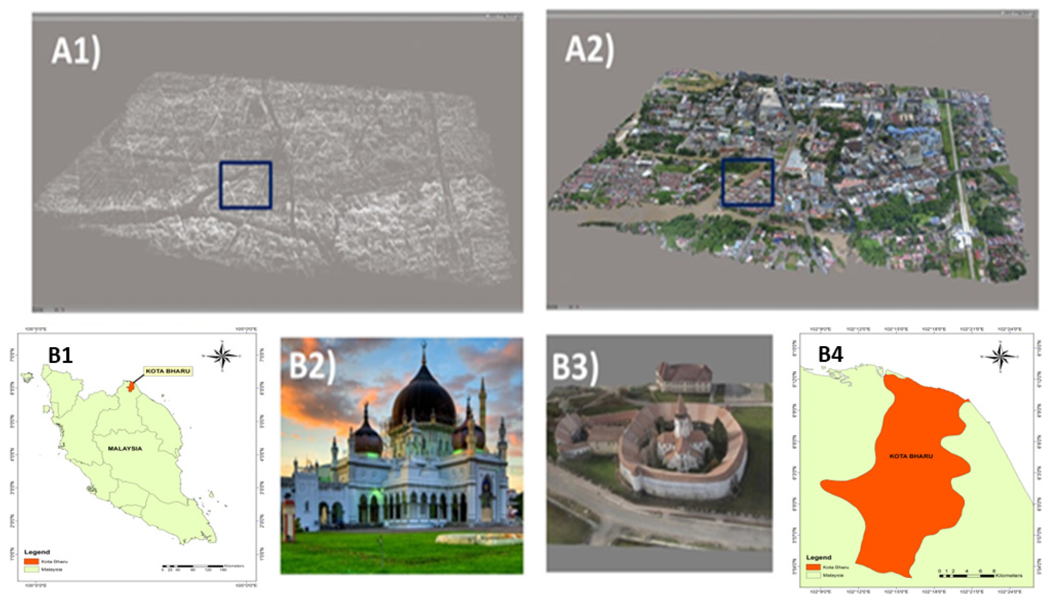
  164. Aiman Abdullah, A.A.; Noor, N.M.; Abdullah, A. Drone 3D Mapping in Identifying Malay Urban Form: Case Study of Kota Bharu. IOP Conf. Ser. Earth Environ. Sci. 2018, 169, 012084. [Google Scholar] [CrossRef]
  165. Noor, N.M.; Afiq, A.; Abdullah, A.; Abdullah, A.; Ibrahim, I.; Sabeek, S. 3D Building Modelling Reconstruction for Sustainable Safeguarding Native Malay Urban Architectural in Malaysia; IOP Publishing: Bristol, UK, 2019; pp. 338–349. [Google Scholar]
  166. Zainudin, A.Z. Application of Drone in Visual Inspection for Construction Project. Bachelor’s Degree Thesis, University Malaysia Pahang, Pahang, Malaysia, 2015. [Google Scholar]
  167. Kaamin, M.; Razali, S.N.M.; Ahmad, N.F.A.; Bukari, S.M.; Ngadiman, N.; Kadir, A.A.; Hamid, N.B. The Application of Micro UAV in Construction Project; AIP Publishing LLC: Kedah, Malaysia, 2017; p. 020070. [Google Scholar]
  168. Bravo-Bello, J.C.; Martinez-Trinidad, T.; Valdez-Lazalde, J.R.; Romero-Sanchez, M.E.; Martinez-Trinidad, S. Analyzing Potential Tree-Planting Sites and Tree Coverage in Mexico City Using Satellite Imagery. Forests 2020, 11, 423. [Google Scholar] [CrossRef]
  169. Civil Aviation Authority of Malaysia. CAAM Report for Remote Pilot Training Organization; CAD 6011 Part (I); Civil Aviation Authority of Malaysia: Putrajaya, Malaysia, 2022.
  170. Abd Mukti, S.N.; Tahar, K.N. Low Altitude Photogrammetry for Urban Road Mapping. Built Environ. J. 2021, 18, 31. [Google Scholar] [CrossRef]
  171. CAAM. Civil Aviation Directive—6011 Part V Unmanned Aircraft System, Special UAS Project; Civil Aviation Authority of Malaysia: Putrajaya, Malaysia, 2021; p. 230.
  172. Srivetbodee, S.; Igel, B. Digital Technology Adoption in Agriculture: Success Factors, Obstacles and Impact on Corporate Social Responsibility Performance in Thailand’s Smart Farming Projects. Thammasat Rev. 2021, 24, 149–170. [Google Scholar] [CrossRef]
  173. Zhou, G.; Tan, Z.; Cheng, P.; Chen, W. Modeling and Visualizing 3d Urban Environment Via Internet for Urban Planning and Monitoring. In Proceedings of the International Society for Photogrammetry and Remote Sensing; Elsevier: Amsterdam, The Netherlands, 2004; pp. 1–7. [Google Scholar]
  174. KPKT. Malaysia Smart City Framework; Ministry of Housing and Local Government: Putrajaya, Malaysia, 2018.
  175. Hashim, A.S.; Tamizi, M.S.M. Development of Drone for Search and Rescue Operation in Malaysia Flood Disaster. Int. J. Eng. Technol. 2018, 7, 9–12. [Google Scholar] [CrossRef]
  176. Samad, A.; Alvarez Florez, D.; Chourdakis, I.; Vogt, U. Concept of Using an Unmanned Aerial Vehicle (UAV) for 3D Investigation of Air Quality in the Atmosphere—Example of Measurements Near a Roadside. Atmosphere 2022, 13, 663. [Google Scholar] [CrossRef]
  177. Wagner, B.; Egerer, M. Application of UAV Remote Sensing and Machine Learning to Model and Map Land Use in Urban Gardens. J. Urban Ecol. 2022, 8, juac008. [Google Scholar] [CrossRef]
Figure 1. Identification of databases and new registers.
Remotesensing 15 02845 g001
Figure 2. A high-quality image of (a) quadcopter/multi-rotor and (b) fixed-wing UAVs.
Remotesensing 15 02845 g002
Figure 3. Overview of UAV components.
Remotesensing 15 02845 g003
Figure 4. Type of imagery (a) 2D aerial imagery acquired via UAV; (b) 3D model built from UAV imagery.
Remotesensing 15 02845 g004
Figure 5. Pictures showing UAVs being used for (a) delivery/first aid; (b) construction purposes.
Remotesensing 15 02845 g005
Figure 6. Mobile app displaying UAV-flying zones.
Remotesensing 15 02845 g006
Figure 7. High-resolution picture showing site inspection using UAVs.
Remotesensing 15 02845 g007
Figure 8. Percentage of Urban Population in the year 2015 and 2020. Source: [146]).
Remotesensing 15 02845 g008
Figure 9. UAV-based environmental protection work carried out in Malaysia: (a) water pollution detection, (b) landslide monitoring, and (c) landscape change analysis. Source: [147,161,162].
Remotesensing 15 02845 g009
Figure 10. (A1A2) 3D point clouds and 3D models; (B1B4) heritage monument location in map, point cloud/imagery, 3D models, and top view.
Remotesensing 15 02845 g010
Figure 11. Construction building in Sri Manjung Specialist Centre, Perak: (a) image from the top of the building during the first flight on 23 September 2016, (b) image from the top of the building during the third flight on 25 November 2016, (c) images from the first side of the building, and (d) image from the second side of the building. Source: [165].
Remotesensing 15 02845 g011
Figure 12. The trend for the percentage types of home renovation: 1. back yard, 2. front yard, and 3. side yard.
Remotesensing 15 02845 g012
Table 1. UAV Categories.
UAV CategoriesDescription
Fixed wingA UAV with a fixed wing and propeller that allows it to fly long distances and remain airborne for extended periods. Typically used for surveying, mapping, and monitoring applications.
MultirotorA UAV with multiple rotors (usually four, six, or eight) that provide lift and maneuverability. Commonly used for aerial photography and videography, as well as recreational purposes.
Single-rotor helicopterA UAV with a single rotor and a tail rotor for stability and control. Often used in professional settings such as search and rescue, law enforcement, and military applications.
HybridA UAV that combines features of both fixed-wing and multirotor UAVs. Capable of long-distance flight as well as vertical take-off and landing. Used for various industrial and commercial applications.
NanoA small UAV that can fit in the palm of your hand. Typically used for indoor flying and aerial photography.
RacingA high-speed UAV designed for competitive racing. Often equipped with first-person view (FPV) cameras to allow pilots to race through courses from a first-person perspective.
AutonomousA UAV that can operate without human intervention. Typically used for surveillance, mapping, and monitoring applications.
DeliveryA UAV designed to transport packages or other payloads. Currently being tested for various commercial applications, including delivering food and medical supplies.
Table 2. Classification of UAV applications.
UAV TypeFeaturesUse Cases
Micro/NanoSmall, lightweight, agileIndoor inspection, search and rescue in tight spaces, aerial photography
Fixed-WingLong range, high speed, high enduranceTraffic monitoring, surveying, and mapping, agriculture, infrastructure inspection
MultirotorManeuverable, agile, versatileAerial photography, videography, delivery, search and rescue, inspection
HybridVertical take-off and landing (VTOL), long rangeEmergency response, surveillance, delivery
AutonomousGPS and sensor-enabled navigation, obstacle avoidanceSurveillance, inspection, mapping and surveying, search, and rescue
Table 3. Current regulations applied to UAVs in Malaysia. Source: [90].
RegulationDescription
Civil Aviation Regulation Governs the operation of UAVs for commercial and recreational purposes. Includes rules on UAV registration, flight restrictions, and air traffic control requirements.
Malaysian Communications and Multimedia Commission Act 1998Regulates the use of radio frequencies for UAV communication and control. Requires UAVs to use frequencies allocated by the commission
Malaysian Aviation Commission Act Establishes the Malaysian Aviation Commission, which is responsible for regulating aviation in Malaysia, including UAVs.
Guidelines for the Flying of Unmanned Aircraft Systems (UAS) in MalaysiaGuides the safe and legal operation of UAVs in Malaysia, including requirements for pilot certification, UAV registration, and flight safety.
Restricted Areas (Temporary) (Amendment) Order Aeronautical Information Publication MalaysiaDefines the boundaries of restricted airspace in Malaysia, including areas around airports, military bases, and other sensitive locations.
Aeronautical Information Publication MalaysiaContains information on airspace and air navigation procedures for aviation in Malaysia, including rules and regulations for UAVs.
Personal Data Protection Act 2010Regulates the collection, use, and disclosure of personal data in Malaysia, including data collected by UAVs.
Table 4. Common UAVs, sensors, and applications in urban planning.
UAV ModelSensorApplications
DJI Phantom 4 ProRGB CameraMapping of urban areas, 3D modeling, building inspections
DJI Mavic 2 EnterpriseThermal CameraDetection of heat loss in buildings, search and rescue operations
Parrot Anafi USAMultispectral CameraMonitoring of vegetation health, identification of land-use patterns
Autel Robotics EVO IILiDAR Sensor3D mapping of urban areas, building inspections
Skydio 2RGB cameraMonitoring of construction sites, traffic analysis
WingtraOneRGB and multispectral camerasMapping of large areas, monitoring of land-use changes
Table 5. Usage of UAVs from the year 2016 to 2021 in Malaysia. Source: [169].
YearNumber of Registered UAVs in Malaysia
2016300
20171000
20183000
20194500
20206000
20218000
Disclaimer/Publisher’s Note: The statements, opinions and data contained in all publications are solely those of the individual author(s) and contributor(s) and not of MDPI and/or the editor(s). MDPI and/or the editor(s) disclaim responsibility for any injury to people or property resulting from any ideas, methods, instructions or products referred to in the content.

