Article

Potential Habitats and Their Conservation Status for Swan Geese (Anser cygnoides) along the East Asian Flyway

1
Key Laboratory of Ecosystem Network Observation and Modeling, Institute of Geographic Sciences and Natural Resources Research, Chinese Academy of Sciences, Beijing 100101, China
2
College of Resources and Environment, University of Chinese Academy of Sciences, Beijing 100101, China
3
College of Environment and Ecology, Chongqing University, Chongqing 400044, China
*
Author to whom correspondence should be addressed.
Remote Sens. 2022, 14(8), 1899; https://doi.org/10.3390/rs14081899
Submission received: 30 January 2022 / Revised: 3 April 2022 / Accepted: 12 April 2022 / Published: 14 April 2022
(This article belongs to the Special Issue Application of Remote Sensing in Migratory Birds Conservation)

Abstract

:
Habitats provide essential space for migratory birds to survive and reproduce. Identifying potential habitats in annual cycle stages and their influencing factors is indispensable for conservation along the flyway. In this study, we obtained satellite tracking of eight swan geese (Anser cygnoides) wintering at Poyang Lake (28°57′4.2″, 116°21′53.36″) from 2019 to 2020. Using the Maximum Entropy species distribution model, we investigated the potential habitats distribution of the swan geese during their migration cycle. We analyzed the relative contribution of various environmental factors to habitat suitability and conservation status for each potential habitat along the flyway. Our results show that the primary wintering grounds of swan geese are located in the middle and lower reaches of the Yangtze River. Stopover sites were widely distributed, mainly in the Bohai Rim, the middle reaches of the Yellow River, and the Northeast Plain, and extended westward to Inner Mongolia and Mongolia. Breeding grounds are mainly in Inner Mongolia and eastern Mongolia, while some are scattered in Mongolia’s central and western. The contribution rates of major environmental factors are different in breeding grounds, stopover sites, and wintering grounds. Breeding grounds were influenced by slope, elevation, and temperature. Slope, human footprint index, and temperature were the main factors that affected stopover sites. Wintering grounds were determined by land use, elevation, and precipitation. The conservation status of habitats is 9.6% for breeding grounds, 9.2% for wintering grounds, and 5.3% for stopover sites. Our findings thus provide a critically international assessment of potential habitats protection for geese species on the East Asian Flyway.

Graphical Abstract

1. Introduction

Habitats provide essential space for species to survive and reproduce [1]; therefore, identifying habitats for species and their influencing factors is a fundamental ecological issue [2,3]. According to The United Nations Convention on Biological Diversity (CBD), it is recommended that protected areas should be expanded and well connected to conserve biodiversity effectively. However, human-induced habitat loss has exacerbated the threats to global biodiversity [4,5], especially to migratory birds. Local wetlands aridification caused by rising temperature and precipitation pattern changes have also caused a severe decline in waterbird populations [6,7,8]. Therefore, identifying species’ potential habitats and their influencing factors can provide scientific information for their habitat protection to promote biodiversity maintenance.
It is challenging to capture species distribution characteristics using traditional research on a large scale; therefore, the study has generally been limited to relatively small areas [9,10] and short survey periods [11]. However, for species that migrate over large distances, it is essential to study suitable habitats throughout their entire migration cycle, as fragmentation and loss of habitat at any stage of the cycle may affect the population dynamics of the species [12]. The availability of Global Positioning System (GPS) loggers and other trackers has greatly improved our ability to study animal movements [13]. In particular, remote monitoring has enabled research into the habitats of long-distance migrants. GPS has become an indispensable technical tool for studying bird migration [14,15] and habitat selection [16,17].
The vast wetlands in East Asia provide critical breeding, stopover, and wintering sites for numerous waterbirds and play an essential role in maintaining the persistence of their populations [18]. As long-distance migrants, such species are exposed to more diverse spatial environments than species that migrate on smaller scales. Therefore, long-distance migrants face a potentially greater range of threats via numerous factors that can affect the habitats along their migration routes, such as climate change [19], fire [20], and disturbances caused by human activities [21]. Furthermore, migration can be affected by different environmental factors at different stages. However, we still know little about the factors affecting the potential distribution of various habitats during complete migration, including breeding grounds, stopover sites, and wintering grounds. Meanwhile, due to the widespread loss of waterbird habitat [10,22,23], the population of globally threatened or monophagous geese on the migration routes of the East Asia Flyway has decreased, such as swan geese (Anser cygnoides) and lesser white-fronted geese (Anser erythropus) [24]. In addition, research has confirmed that the distribution of geese has changed, and the change of wintering grounds is the most significant [25], leading to these species becoming threatened. Therefore, it is important to characterize the distribution of geese and potential habitats along their migration routes.
Swan geese are an essential part of the overall population of East Asian geese. However, their habitats are shrinking, with populations likely decreasing. Swan geese are classified as vulnerable (VU) species in the International Union for Conservation of Nature’s Red List (IUCN red list) [26]. To adapt to seasonal fluctuations in the environments, swan geese migrate between their wintering grounds and breeding grounds annually [27], and their habitats are diverse and dispersed. GPS satellite trackers for obtaining location data of swan geese on a fine spatiotemporal scale provide a major opportunity for identifying their habitat distribution patterns.
In this study, we used GPS tracking data and environmental variables as the data sources of the Maximum Entropy (MaxEnt) model to predict and verify the potential habitat distribution of breeding grounds, stopover sites, and wintering grounds on the flyway of East Asian swan geese. We also explored the dominant environmental factors determining habitat selection and assessed the conservation status of each potential habitat along the flyway. This research will provide scientific support for optimizing the spatial distribution of protected areas. Additionally, this will also increase the connectivity of East Asian goose habitats and help to achieve the CBD’s conservation objectives.

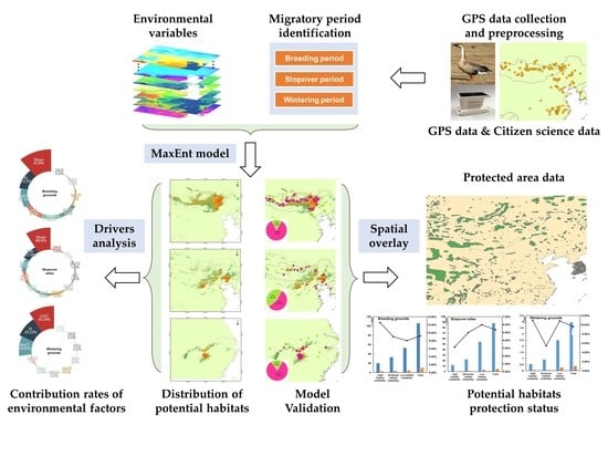
2. Materials and Methods

2.1. Study Area

Our study area spanned over 25°N–60°N and 90°E–130°E, based on the maximum latitude and longitude range of swan geese’s GPS satellite tracking data (Figure 1). This study area mainly includes multiple regions of China, Mongolia, North and South Korea, which is part of the East Asian–Australasian Flyway identified by the global monitoring program of Wetland International. Anseriformes are common in this region [28], with nearly 400,000 geese wintering in the middle and lower reaches of the Yangtze River every year, including at least 56,000 swan geese [29]. Additionally, this area is rich in natural wetland resources. Several rivers run through this area, such as the Yangtze River, the Yellow River, the Liao River, and the Selenga River. Ninety wetlands, including Poyang lake, Dalai lake, and Ögii lake, are on the Ramsar Convention’s list of Wetlands of International Importance (www.ramsar.org/sites, accessed on 15 June 2021). Diverse bird habitats [30] provide breeding, stopover, and wintering sites for waterfowl and marsh birds during their annual migration.

2.2. GPS Data Collection and Preprocessing

We captured eight swan geese individuals without causing injury or harm through the maze tool at their wintering ground in Poyang Lake National Nature Reserve to collect the species distribution data [31]. We used Teflon ribbon harnesses to fit each individual with a backpack GPS transmitter (HQBG 3621S, Hunan Global Messenger Technology Company, China). The GPS transmitter weighs 24 g, which is less than 3% of the range weight (2738–4510 g), and this has been shown to have a minimal effect on their everyday activities [32]. The GPS transmitter sensor records data every hour, both day and night. In this study, we wanted to explain which areas can be used as the potential habitat of geese during the whole breeding, stopover, and wintering period on a large scale. So, the GPS records were divided according to the flying or non-flying status of swan geese. As long as the points were non-flying (resting and foraging) within three-period, they were used for the MaxEnt model.
Swan geese data processing included analyzing non-flying states and divided migration stages, and we also filtered the data to improve the accuracy of the following potential habitats simulation. The data processing method was as follows (Figure 2). First, we kept data points with the horizontal or vertical dilution of precision (HDOP or VDOP) less than 20 and with positioning satellites greater than or equal to 4 [33]. We retained data at the highest efficiency levels (A, B, and C). Meanwhile, we removed the data of spatiotemporal duplication and outliers of velocity or angle using the R package SDLfilter [34]. Secondly, we determined the flying or non-flying status using Expectation-Maximization binary Clustering (EMbC). This approach was made unsupervised, based on the high and low values of speed and turning angle of each GPS position. All positions were classified into four categories, where low velocities and low turns (LL) can be interpreted as resting, low velocities and high turns (LH) as foraging, high velocities and low turns (HL) as traveling or relocation, and high velocities and high turns (HH) as extensive search [35]. We selected LL and LH as non-flying statuses for potential habitat research. Third, we ensured that species distribution points accurately reflect available habitat features [36]. We used least-squares cross-validation to select positions within 95% kernel density estimates based on the reproducible home ranges (rhr) package [37]. Fourth, migration stages were determined by the arrival and departure date of GPS sites within the home range. Between 180th and 270th day, points within the home range as the breeding season, between 320th and 120th of the second year as wintering period, and others as stopover periods (Supplementary Materials Table S1). Finally, to eliminate a potential bias of clustered occurrences [38,39], the datasets were filtered using the trim duplicate occurrences module in ecological niche modeling tools (ENMTools) software. There remains one record per 1 km2 cell for swan geese.
We received in total 57,668 original data. After the abovementioned data preprocessing, 2353 locations for 8 swan geese during 2019–2020 were retained throughout their flyway, including 1113 in the breeding season, 698 in stopover periods, and 542 in wintering period (Table S1). These sites were used as sample points in the simulation of potential habitats.

2.3. Environmental Variables

We considered the following environmental variables, including bioclimatic variables (bio1~bio19), land use and land cover (LULC), elevation (EL), slope (Slope), enhanced vegetation index (EVI), and human footprint index (HFI) (Supplementary Materials Table S2). Bioclimate data were derived from WorldClim (version 2.1), which provides a high resolution (~1 km) [40].
LULC data were extracted from the GlobeLand 30 dataset with a resolution of 30 m [41]. Elevation and slope data were obtained from the EarthEnv database, based on the global 250 m Global Multi-resolution Terrain Elevation Data 2010 (GMTED 2010) digital elevation model product [42].
EVI was extracted from the Moderate Resolution Imaging Radiometer (MODIS) MOD13Q1 product available from NASA’s Level-1 and Atmosphere Archive and Distribution System (LAADS) Distributed Active Archive Center (DAAC). We downloaded images for four months of 2020 (January, August, April, and October) and used the MODIS Reprojection Tool (MRT) to splice the images.
The HFI, a proxy of direct and indirect human disturbances, was published by the Wildlife Conservation Society (WCS) and Columbia University’s Center for International Earth Science Information Network (CIESIN) in 2018. The data included eight variables: built-up environments, population density, roads, railways, navigable waterways, etc. [43].
We resampled environmental factors to 1 km resolution and cropped to the same spatial extent. Environmental data filtering eliminates highly relevant bioclimatic factors to avoid the error caused by the over-fitting of the model [44]. First, we entered the filtered geese sites and bioclimatic elements into the MaxEnt model with all parameters, keeping the default settings. The jack-knife test was used to test the contribution rate of dominant bioclimatic factors. Then, the Pearson correlation coefficient (r) was calculated using SPSS to test the correlation between variables (Supplementary Materials Figure S1). The higher contribution factor was selected when the highly correlated environmental factor (Pearson’s r > 0.8). In addition, LULC, EL, Slope, EVI, and HFI were included as environmental factors in the model (Table 1).

2.4. Model Simulation

According to the processed GPS sites and the corresponding environmental factors in the breeding, stopover, and wintering period, we used the MaxEnt model [45] to simulate potentially suitable habitats for swan geese. These suitable habitats served as breeding grounds, stopover sites, and wintering grounds for geese to complete their annual migration, providing space, food resources, and breeding sites. This process was divided into two parts: parameter setting and model verification.

2.4.1. Parameter Setting

Processed GPS sites and environmental variables were input into MaxEnt 3.4.1, with a 75% subset of the geese sites data randomly selected as training data and the remaining 25% as testing data. The logistic model was chosen as the result output format, and default values were used for other parameters. The jack-knife method was used to judge the contribution rate of environmental factors for potential habitat suitability for swan geese. Models were trained for ten repetitions with the bootstrap method. We took the average value as the simulation result for potentially suitable habitats: breeding grounds, stopover sites, and wintering grounds.
Using the logistic outputs of MaxEnt, the maximum sensitivity plus specificity logistic threshold was used to define each pixel into one of two categories, suitable and unsuitable habitat [46,47]. Then, we applied the natural breaks (Jenks) method [48] to reclassify suitable habitats as low, moderate, and high habitat suitability. Finally, the Zoning statistical tools of ArcGIS were used to calculate the area of each potentially suitable habitat.

2.4.2. Model Validation

The model’s performance was evaluated based on the receiver operating characteristic (ROC) curves to calculate the area under the curve (AUC). AUC values can range from 0.5 to 1 [49], and a larger AUC indicates a higher accuracy level.
To illustrate the model’s accuracy, citizen science data for swan geese were used as verification. The citizen observation data were obtained from the Global Biodiversity Information Network (GBIF). We kept the sites where the number of swan geese at each observation point was more than three as validation data. These data all record the survey time, place, and date. We divided the above data into overwintering, stopover, and breeding period based on the survey time and the investigator’s description.

2.5. Protection Status Analysis

We combined Google Earth to analyze the geographic extent of potential habitats distribution. Then, we based on regional statistical tools for ArcGIS to calculate the area of low, moderate, and high habitat suitability, divided by the natural breaks (Jenks) method. Moreover, we investigated the percentage of land use in potential habitats of swan geese according to GPS sites.
To assess the status of the protection of swan geese’s potential suitable habitats in East Asia. We used a raster calculator tool in ArcGIS to perform an overlay analysis of the protected area and the habitat to determine the degree of protection provided to the breeding grounds, stopover sites, and wintering grounds of the swan geese. Protected area data were obtained from the World Database of Protected Areas (WDPA, https://protectedplanet.net, accessed on 20 June 2021). There are insufficient data on protected areas of China; therefore, China’s National Nature Reserve data come from the Resource and Environmental Science Data Center (http://www.resdc.cn, accessed on 20 June 2021) used as supplementary data.

3. Results

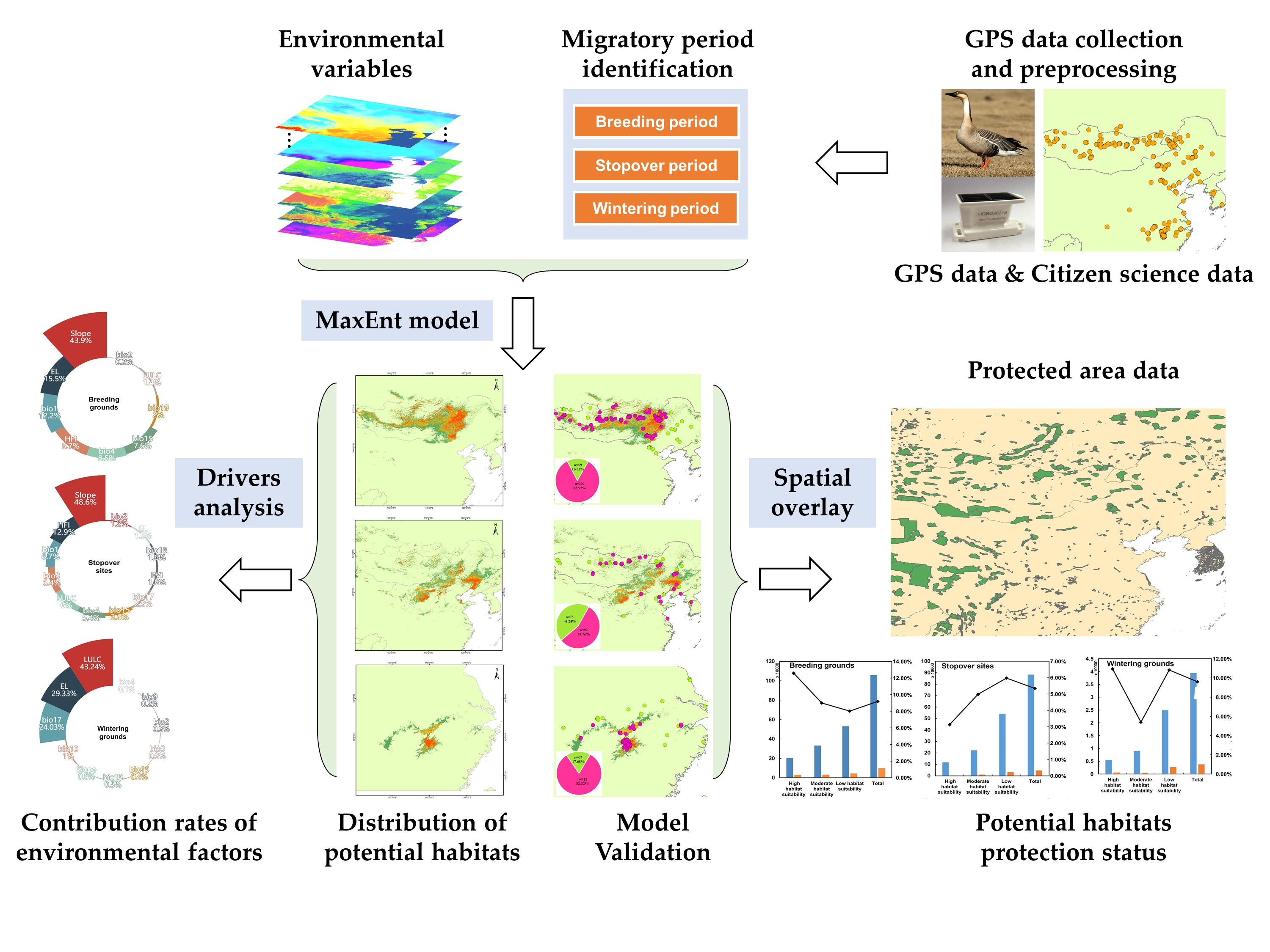
3.1. Validation of Potential Habitats for Swan Geese

After ten cross-validations, the average AUC values of the training and testing sample in breeding grounds, stopover sites, and wintering grounds were higher than 0.9, which indicated that the model had a good predictive ability. Concurrently, the standard deviation of the AUC was less than 0.05, showing that the model had high stability (Supplementary Materials Table S3).
We also verified our results using citizen science data obtained from GBIF for swan geese (912 observation records) (Figure 3). It showed that 83.97% of breeding sites (309 observation records), 55.76% of stopover sites (165 observation records), and 82.32% (379 observation records) of wintering sites were located in suitable habitats. Approximately 74.02% of the citizen science data along the swan geese migration route can be consistent with the simulations’ results.

3.2. Distribution of Potential Habitats for Swan Geese

The MaxEnt model showed that the habitat suitability thresholds for breeding grounds, stopover sites, and wintering sites were 0.18, 0.15, and 0.34, respectively, determined by applying the maximum training sensitivity plus specificity. We calculated the suitable habitats distribution (Figure 3) and habitat suitability areas (Table 2) and the proportion of geese using land use according to GPS sites (Figure 4).
The breeding grounds were mainly distributed in Inner Mongolia and Mongolia (Figure 3(a1)), with 1,058,323 km2. Highly suitable habitats were distributed in Hulun Lake and Dalinor Lake in Inner Mongolia and in Buir Lake and Selenga River wetlands in Mongolia, covering an area of 199,423 km2. Moderately suitable habitats were located in eastern Inner Mongolia and eastern and northern Mongolia, with 330,047 km2 in total. Lowly suitable habitats were found in central Inner Mongolia and Mongolia, with 528,853 km2. The main land use of breeding areas was grassland (50.2%), wetland and water bodies (31.4%), and bare ground (13.1%).
The stopover sites were mainly distributed in the wetlands of the Liao River, the Yellow River Delta wetlands, the wetlands along the middle reaches of the Yellow River, and Inner Mongolia (Figure 3(b1)), covering an area of 883,607 km2, and the highly, moderately, and lowly suitable habitats were 118,366 km2, 222,763 km2, and 542,478 km2, correspondingly. Land use of stopover sites was diverse, including 44.0% of wetland and water bodies, 35.0% grassland, 12.0% cultivated land, and 13.1% bare land.
The wintering grounds were located in Poyang Lake, Dongting Lake, and other river and lake wetlands in the middle and lower reaches of the Yangtze River (Figure 3(c1)), with 39,424 km2. Among them, the highly suitable habitats account for 13.93%. The primary land use was wetlands and water bodies, accounting for 96.7%.

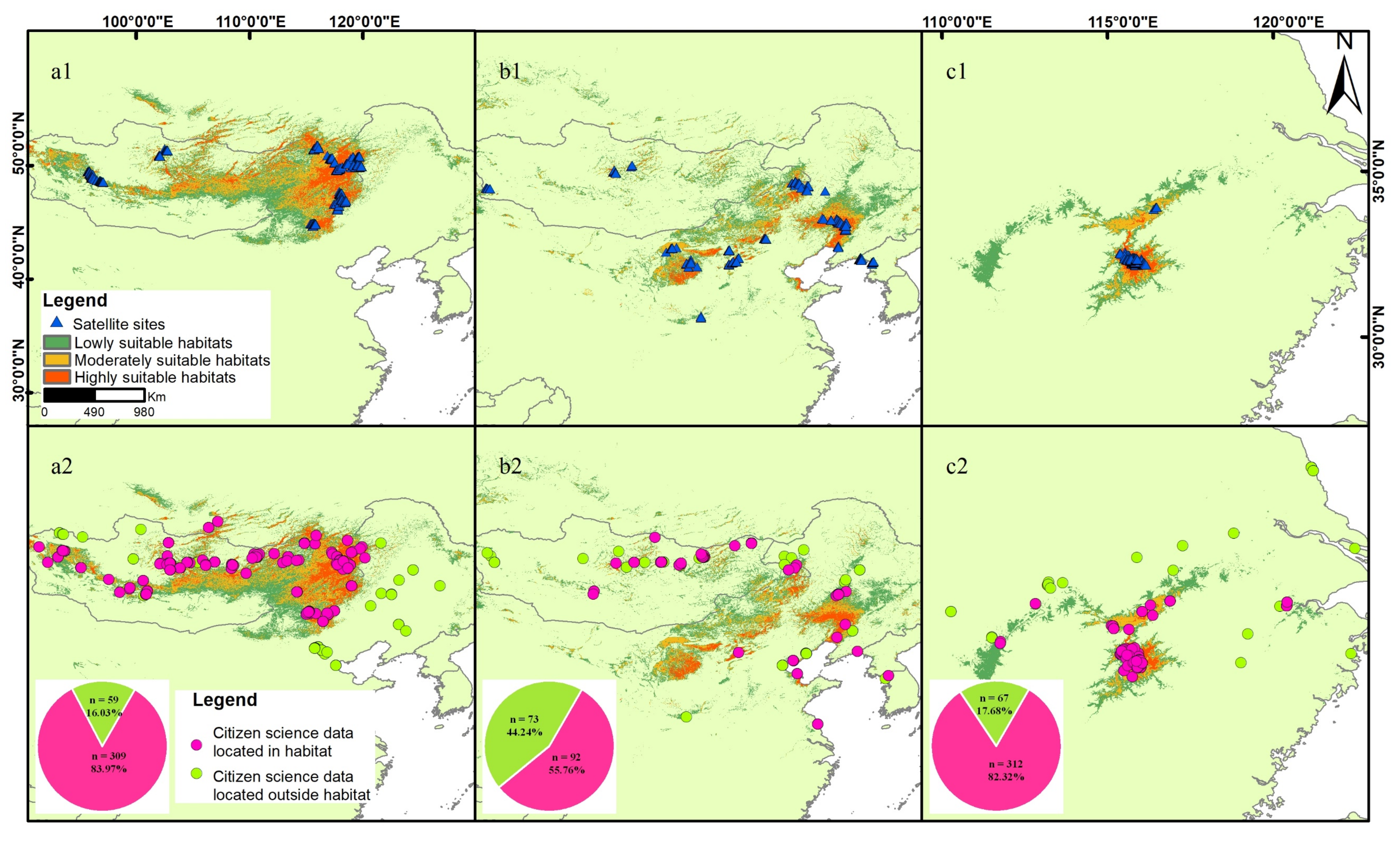
3.3. Main Environmental Factors

The contribution rates of major environmental factors were significantly different in the MaxEnt model of breeding grounds, stopover sites, and wintering grounds (Figure 5). Breeding grounds and stopover sites were primarily affected by the slope, which is approximately 0° is suitable, while wintering grounds were affected mainly by land use and land cover (LULC), especially wetlands and water bodies, with contribution rates greater than 40%. The annual mean temperature (bio1) contribution rate was 12.2% and 8.7% in breeding grounds and stopover sites, with suitable ranges of −2–2 °C and −2–10 °C, respectively. The contribution rate of wintering grounds by the precipitation of the driest quarter (bio17) was 24.03%, and the precipitation range was about 150–340 mm. In addition, the breeding and wintering grounds were also influenced by elevation (EL), with contribution rates of 15.5% and 29.33%, respectively. The stopover sites were affected by a human footprint index (HFI) of 12.9%, the suitability range being in the range of around 5–10, and then decreasing as the disturbance increased. (Figures S2–S4 for the range of environmental factors affecting potential habitat).

3.4. Analysis of Habitat Protection Status

We overlaid the potentially suitable habitat derived from the MaxEnt model and the layer of protected areas to evaluate the protected status of swan geese. There are vast conservation gaps in potential habitats, and just 9.6% in breeding grounds (Figure 6a), 5.3% at stopover sites (Figure 6b), and 9.2% in wintering grounds were located in protected areas (Figure 6c).

4. Discussion

4.1. GPS Data Used for Habitat Simulation

Based on the swan geese location data acquired by GPS satellite trackers and the MaxEnt model, we evaluated the potential habitats of swan geese in breeding, stopover, and wintering areas on their annual migration route. Our results showed that the MaxEnt model of habitat suitability has high accuracy and stability. Additionally, the validation result of the citizen science data indicated that the model has a high degree of credibility. GPS is now an efficient tool for studying larger-bodied waterfowl habitats at broad spatiotemporal scales [50,51].
Our results show that GPS satellite sites play an essential role in identifying the habitats that make up some information missing from citizen science data. It captured the stopover distribution range of swan geese in the Yellow River Basin. At the same time, there is also some omission of information limited to the time series of satellite tracking, such as the wintering grounds in Dongting Lake [52]. These circumstances’ probability is that there may be different sub-groups in the Middle and lower Yangtze River. Swan geese have fidelity [53] to particular wintering sites captured in Poyang Lake and will mainly use wetland, resulting in a deviation in model results.
Therefore, we suggest increasing the amount of GPS trackers and capturing the species in multiple locations covered by breeding, wintering, and stopover sites to avoid model deviation caused by data.

4.2. Significant Factors Affecting Habitat Suitability

The environmental factors affecting the potential habitats at breeding grounds were slope and elevation, where the slope was approximately 0°, and the elevation was 500–1000 m. The main reason for this is that breeding grounds were located in the steppe area of the Mongolian Plateau [54], which has numerous grassland wetlands and lakes; our results also show that habitats in this area included 50.2% grassland and 31.4% wetlands. These flat, high-altitude lowlands provide a habitat for the nesting and molting of swan geese. Another factor affecting breeding grounds was temperature, the appropriate range of which provides the necessary conditions for the hatching of young geese [55].
The stopover sites of swan geese were widely distributed throughout the Northeast Plain, in the middle and lower reaches of the Yellow River, and around the Bohai Sea. The human footprint index (HFI) for stopover habitats was approximately 5–10; with an increase in the HFI greater than 10, habitat suitability reduces. A recent study indicates that the North China Plain and the Northeast Plain have experienced rapid urbanization [56], massive loss of water bodies and wetlands at stopover sites [57], and human activities have affected habitat suitability to varying degrees.
Wintering grounds were influenced primarily by land use, elevation, and the precipitation of driest quarter (bio17). In winter, the swan geese were limited to wetlands in the middle and lower reaches of the Yangtze River, mainly bodies of water and wetlands. The habitat of overwintering geese is also affected by hydrological and vegetation characteristics changes in winter [58,59].

4.3. The Challenge of Protecting Swan Geese

The breeding grounds in Mongolia are primarily located in arid grasslands with insufficient rainfall [19], and grassland fires have caused the high mortality of swan geese [20,60]. Affected by climate change, the water level of wetlands has receded [54], and combined with the effects of overgrazing [61], the habitat is threatened at their breeding grounds. Although this threat is relatively small compared to other zones [20], its protection cannot be ignored.
Overwintering swan geese are almost entirely restricted to China, mainly in the middle and lower reaches of the Yangtze River [25,62], where food resources are limited; therefore, winter protection is critical. Although our model results show that the habitat suitability of Dongting Lake is low, it provides abundant food sources and habitats for overwintering populations, such as lesser white-fronted goose, bean geese (Anser fabalis), and greater white-fronted geese (Anser albifrons) [63]. They often form mixed-species groups, so protecting the habitat in Dongting Lake is also of great significance for other geese. In addition, our results show that precipitation has an important effect on wintering grounds, whose distribution is affected by hydrological status [58]. We thus suggest that water levels in winter should be appropriately controlled, and the relationship between hydrology, vegetation, and geese habitats should be well coordinated.
For migratory birds, stopover sites are crucial to maintaining their periodic migration. However, conservation shortfalls in stopover sites have imposed significant threats to East Asian swan geese for the following reasons. First, the stopover sites are disturbed by human interference [64]; this is consistent with our findings that they are affected by the human footprint index (HFI, 12.9%) and land use and land cover (LULC, 6%). Second, our results show that the current protection representativeness at stopover sites was low. Significantly, the high habitat suitability had the lowest rate of protected areas (3.1%), which indicates that the stopover sites are insufficient for the swan geese. Third, the stopover sites of swan geese depend on diverse natural habitats [65]; our results also show that the land use was wetlands, grassland, cultivated land, bare land, artificial surfaces, and forest. Additionally, they are distributed in the Bohai Rim, the Northeast Plain, and the border between Mongolia and Inner Mongolia. Different regions face different protection challenges; for instance, coastal wetlands are threatened by reclamation [66], and the Northeast Plain is threatened by climate change and cultivation [67]. Diversified and dispersed stopover sites are the primary habitat conservation challenges.
The overall degree of protection of suitable habitat along the East Asian geese migration route is relatively low, and the primary factors affecting the breeding grounds, stopover sites, and wintering grounds are also different. Therefore, various measures should be concerned when enacting conservation activities according to the threatening factors of different habitats. As swan geese migrate across China, Mongolia, North Korea, and other countries, multiple countries must work together to maintain swan geese habitats.

5. Conclusions

The GPS tracking data and MaxEnt model were used in this study to assess the habitat suitability of swan geese along the East Asia flyway. According to the citizen science data obtained from GBIF used to verify the model, 74.02% of the observation sites were consistent with the distribution of suitable habitats, and the model has a high stability (standard deviation < 0.05). The wintering grounds are mainly distributed in Poyang Lake and the middle and lower Yangtze River, influenced by land use, elevation, and precipitation of the driest quarter (bio17). Affected by slope, human footprint index (HFI), and the annual mean temperature (bio1), the stopover sites are located in the Circum-Bohai-Sea region, the middle reaches of the Yellow River, the Northeast Plain, and the Hulun Buir Plateau. The breeding grounds are situated in the junction of Inner Mongolia and Mongolia and part of central and western Mongolia, where slope, elevation, and bio1 contributed significantly to the habitat. The habitat of swan geese was not well protected; the proportions of protected breeding grounds, wintering grounds, and stopover sites were 9.6%, 9.2%, and 5.3%, respectively. Therefore, potential habitat protection for swan geese along migration routes should be strengthened, especially in the stopover sites.

Supplementary Materials

The following supporting information can be downloaded at: https://www.mdpi.com/article/10.3390/rs14081899/s1. Figure S1: Pearson correlation coefficient of bioclimatic factors. The blue cross indicates the difference is not significant (p > 0.05); all remaining differences were significant (p < 0.001); Figure S2: The response curve of distribution probability of swan geese in breeding grounds; Figure S3: The response curve of distribution probability of swan geese in stopover sites; Figure S4: The response curve of distribution probability of swan geese in wintering grounds; Table S1: The amount of data processed by GPS satellite tracking data; Table S2: Environmental variables and relative data descriptions for the Maximum Entropy (MaxEnt) distribution model were used to simulate potential habitats of swan geese (Anser cygnoides) in this study; Table S3: Accuracy evaluation for training and testing samples of swan geese (Anser cygnoides) habitat in the Maximum Entropy (MaxEnt) distribution model.

Author Contributions

Conceptualization, X.Y. and W.Z.; data collection, S.X.; methodology, C.W.; investigation, S.X. and C.W.; writing—original draft preparation, C.W.; writing—review and editing, S.X., Y.L. and J.H.; supervision, Y.L., S.X, and X.Y.; project administration, X.Y. All authors have read and agreed to the published version of the manuscript.

Funding

This work was jointly supported by the National Natural Science Foundation of China (Grant No. 42171105), Strategic Priority Research Program of the Chinese Academy of Science, China (Grant No.XDA19020305), and Network information program of Chinese Academy of Science, China (CAS-WX2021SF-0501).

Data Availability Statement

The verification data can be found at the Global Biodiversity Information Network (GBIF) (https://www.gbif.org/, accessed on 29 June 2021).

Acknowledgments

We would like to thank Houlang Duan and Jiakun Teng for comments on the manuscript. We thank Clio Reid for editing the English text of a draft of this manuscript. We thank three anonymous reviewers for their valuable comments and suggestions.

Conflicts of Interest

The authors declare no conflict of interest.

References

  1. Cody, M.L. Habitat Selection in Birds; Academic Press: Cambridge, MA, USA, 1985. [Google Scholar]
  2. Weller, M.W. Wetland Birds: Habitat Resources and Conservation Implications; Cambridge University Press: Cambridge, UK, 1999. [Google Scholar]
  3. Hildén, O. Habitat selection in birds: A review. Ann. Zool. Fenn. 1965, 2, 53–75. [Google Scholar]
  4. Fischer, J.; Lindenmayer, D.B. Landscape modification and habitat fragmentation: A synthesis. Global Ecol. Biogeogr. 2007, 16, 265–280. [Google Scholar] [CrossRef]
  5. Kirby, J.S.; Stattersfield, A.J.; Butchart, S.; Evans, M.I.; Newton, I. Key conservation issues for migratory land- and waterbird species on the world’s major flyways. Bird Conserv. Int. 2008, 18, S49–S73. [Google Scholar] [CrossRef] [Green Version]
  6. Haig, S.M.; Murphy, S.P.; Matthews, J.H.; Arismendi, I.; Safeeq, M. Climate-Altered Wetlands Challenge Waterbird Use and Migratory Connectivity in Arid Landscapes. Sci. Rep. 2019, 9, 4666. [Google Scholar] [CrossRef] [PubMed] [Green Version]
  7. Roshier, D.A.; Robertson, A.I.; Kingsford, R.T. Responses of waterbirds to flooding in an arid region of Australia and implications for conservation. Biol. Conserv. 2002, 106, 399–411. [Google Scholar] [CrossRef]
  8. Brandis, K.J.; Bino, G.; Spencer, J.A.; Ramp, D.; Kingsford, R.T. Decline in colonial waterbird breeding highlights loss of Ramsar wetland function. Biol. Conserv. 2018, 225, 22–30. [Google Scholar] [CrossRef]
  9. An, A.; Zhang, Y.; Cao, L.; Jia, Q.; Wang, X. A potential distribution map of wintering Swan Goose (Anser cygnoides) in the middle and lower Yangtze River floodplain, China. Avian Res. 2018, 9, 43. [Google Scholar] [CrossRef] [Green Version]
  10. Duan, H.; Yu, X.; Xia, S.; Zhang, G. Waterbird habitat loss fringing the Yellow and Bohai seas along the East Asian—Australasian migratory flyway. Land Degrad. Dev. 2021. accepted. [Google Scholar] [CrossRef]
  11. Wang, Y.; Gong, M.; Zou, C.; Zhou, T.; Wen, W.; Liu, G.; Li, H.; Tao, W. Habitat selection by Siberian Cranes at their core stopover area during migration in Northeast China. Glob. Ecol. Conserv. 2022, 33, e1993. [Google Scholar] [CrossRef]
  12. Xu, Y.; Si, Y.; Wang, Y.; Zhang, Y.; Prins, H.H.T.; Cao, L.; de Boer, W.F. Loss of functional connectivity in migration networks induces population decline in migratory birds. Ecol. Appl. 2019, 29, e1960. [Google Scholar] [CrossRef] [Green Version]
  13. Wilmers, C.C.; Nickel, B.; Bryce, C.M.; Smith, J.A.; Wheat, R.E.; Yovovich, V. The golden age of bio-logging: How animal-borne sensors are advancing the frontiers of ecology. Ecology 2015, 96, 1741–1753. [Google Scholar] [CrossRef] [PubMed]
  14. Xin, W.; Lei, C.; Fox, A.D.; Fuller, R.; Ran, N. Stochastic simulations reveal few green wave surfing populations among spring migrating herbivorous waterfowl. Nat. Commun. 2019, 10, 2187. [Google Scholar]
  15. Monti, F.; Grémillet, D.; Sforzi, A.; Sammuri, G.; Dominici, J.M.; Triay Bagur, R.; Muñoz Navarro, A.; Fusani, L.; Duriez, O. Migration and wintering strategies in vulnerable Mediterranean Osprey populations. IBIS 2018, 160, 554–567. [Google Scholar] [CrossRef]
  16. Gao, B.; Gong, P.; Zhang, W.; Yang, J.; Si, Y. Multiscale effects of habitat and surrounding matrices on waterbird diversity in the Yangtze River Floodplain. Landsc. Ecol. 2021, 36, 179–190. [Google Scholar] [CrossRef]
  17. Xu, Y.; Si, Y.; Yin, S.; Zhang, W.; Grishchenko, M.; Prins, H.H.; Gong, P.; de Boer, W.F. Species-dependent effects of habitat degradation in relation to seasonal distribution of migratory waterfowl in the East Asian-Australasian Flyway. Landsc. Ecol. 2019, 34, 243–257. [Google Scholar] [CrossRef] [Green Version]
  18. Duan, H.; Xia, S.; Yu, X.; Liu, Y.; Teng, J.; Dou, Y. Using citizen science data to inform the relative sensitivity of waterbirds to natural versus human-dominated landscapes in China. Ecol. Evol. 2020, 10, 7233–7241. [Google Scholar] [CrossRef]
  19. John, R.; Chen, J.; Kim, Y.; Ou-Yang, Z.T.; Xiao, J.; Park, H.; Shao, C.; Zhang, Y.; Amarjargal, A.; Batkhshig, O. Differentiating anthropogenic modification and precipitation-driven change on vegetation productivity on the Mongolian Plateau. Landsc. Ecol. 2016, 31, 547–566. [Google Scholar] [CrossRef]
  20. Ganbold, O.; Munkhbayar, M.; Paik, I.; Bing, G.; Jargalsaikhan, A.; Purevee, E.; Peak, W.K. Globally threatened birds in Mongolia: A review. J. Asia-Pac. Biodivers. 2017, 10, 435–440. [Google Scholar] [CrossRef]
  21. Batbayar, N.; Takekawa, J. Migration strategies of Swan Geese Anser cygnoides from northeast Mongolia. Wildfowl 2011, 61, 90–109. [Google Scholar]
  22. Yu, H.; Wang, X.; Cao, L.; Zhang, L.; Jia, Q.; Lee, H.; Xu, Z.; Liu, G.; Xu, W.; Hu, B.; et al. Are declining populations of wild geese in China ‘prisoners’ of their natural habitats? Curr. Biol. 2017, 27, R376–R377. [Google Scholar] [CrossRef]
  23. Zhao, Q.; Wang, X.; Cao, L.; Fox, A.D. Why Chinese wintering geese hesitate to exploit farmland. IBIS 2018, 160, 703–705. [Google Scholar] [CrossRef] [Green Version]
  24. Lei, C.; Yong, Z.; Barter, M.; Gang, L. Anatidae in eastern China during the non-breeding season: Geographical distributions and protection status. Biol. Conserv. 2010, 143, 650–659. [Google Scholar]
  25. Zhang, Y.; Cao, L.; Barter, M.; Fox, A.D.; Zhao, M.; Meng, F.; Shi, H.; Jiang, Y.; Zhu, W. Changing distribution and abundance of Swan GooseAnser cygnoides in the Yangtze River floodplain: The likely loss of a very important wintering site. Bird Conserv. Int. 2011, 21, 36–48. [Google Scholar] [CrossRef] [Green Version]
  26. International Union for Conservation of Nature. Anser cygnoid. In The IUCN Red List of Threatened Species 2016: e.T22679869A92832782; International Union for Conservation of Nature: Gland, Switzerland, 2016; Volume 2021. [Google Scholar]
  27. Wu, Y.; Yang, Y.; Cao, L.; Yin, H.; Xu, M.; Wang, Z.; Liu, Y.; Wang, X.; Deng, Y. Habitat environments impacted the gut microbiome of long-distance migratory swan geese but central species conserved. Sci. Rep. 2018, 8, 13314. [Google Scholar] [CrossRef]
  28. Wu, H.; Dai, J.; Sun, S.; Du, C.; Long, Y.; Chen, H.; Yu, G.; Ye, S.; Chen, J. Responses of habitat suitability for migratory birds to increased water level during middle of dry season in the two largest freshwater lake wetlands of China. Ecol. Indic. 2021, 121, 107065. [Google Scholar] [CrossRef]
  29. JIa, Q.; Koyama, K.; Choi, C.; Kim, H.; Cao, L.; Gao, D.; Liu, G.; Fox, A.D. Population estimates and geographical distributions of swans and geese in East Asia based on counts during the non-breeding season. Bird Conserv. Int. 2016, 26, 397–417. [Google Scholar] [CrossRef]
  30. Nyambayar, B.; Tseveenmyadag, N. (Eds.) Directory of Important Bird Areas in Mongolia: Key Sites for Conservation; Wildlife Science and Conservation Center, Institute of Biology and BirdLife International: Ulaanbaatar, Mongolia, 2009. [Google Scholar]
  31. Teng, J.; Yu, X.; Xia, S.; Liu, Y. Suitable Habitat Dynamics of Wintering Geese in a Large Floodplain Wetland: Insights from Flood Duration. Remote Sens. 2022, 14, 952. [Google Scholar] [CrossRef]
  32. Kenward, R.E. A Manual for Wildlife Radio Tagging; Academic Press: Cambridge, MA, USA, 2000. [Google Scholar]
  33. Shimada, T.; Jones, R.; Limpus, C.; Hamann, M. Improving data retention and home range estimates by data-driven screening. Mar. Ecol. Prog. Ser. 2012, 457, 171–180. [Google Scholar] [CrossRef] [Green Version]
  34. Shimada, T.; Limpus, C.; Jones, R.; Hazel, J.; Groom, R.; Hamann, M. Sea turtles return home after intentional displacement from coastal foraging areas. Mar. Biol. 2016, 163, 8. [Google Scholar] [CrossRef]
  35. Garriga, J.; Palmer, J.R.B.; Oltra, A.; Bartumeus, F. Expectation-Maximization Binary Clustering for Behavioural Annotation. PLoS ONE 2016, 11, e151984. [Google Scholar] [CrossRef] [Green Version]
  36. Lamb, J.S.; Paton, P.W.; Osenkowski, J.E.; Badzinski, S.S.; Berlin, A.M.; Bowman, T.; Dwyer, C.; Fara, L.J.; Gilliland, S.G.; Kenow, K. Assessing year-round habitat use by migratory sea ducks in a multi-species context reveals seasonal variation in habitat selection and partitioning. Ecography 2020, 43, 1842–1858. [Google Scholar] [CrossRef]
  37. Signer, J.; Balkenhol, N. Reproducible home ranges (rhr): A new, user-friendly R package for analyses of wildlife telemetry data. Wildl. Soc. Bull. 2015, 39, 358–363. [Google Scholar] [CrossRef]
  38. Hernandez, P.A.; Graham, C.H.; Master, L.L.; Albert, D.L. The effect of sample size and species characteristics on performance of different species distribution modeling methods. Ecography 2006, 29, 773–785. [Google Scholar] [CrossRef]
  39. Luo, Z.; Jiang, Z.; Tang, S. Impacts of climate change on distributions and diversity of ungulates on the Tibetan Plateau. Ecol. Appl. 2015, 25, 24–38. [Google Scholar] [CrossRef] [PubMed]
  40. Fick, S.E.; Hijmans, R.J. WorldClim 2: New 1km spatial resolution climate surfaces for global land areas. Int. J. Climatol. 2017, 37, 4302–4315. [Google Scholar] [CrossRef]
  41. Jun, C.; Ban, Y.; Li, S. Open access to Earth land-cover map. Nature 2014, 514, 434. [Google Scholar] [CrossRef] [PubMed] [Green Version]
  42. Danielson, J.J.; Gesch, D.B. Global Multi-Resolution Terrain Elevation Data 2010 (GMTED2010); US Department of the Interior, US Geological Survey: Washington, DC, USA, 2011.
  43. Venter, O.; Sanderson, E.W.; Magrach, A.; Allan, J.R.; Beher, J.; Jones, K.R.; Possingham, H.P.; Laurance, W.F.; Wood, P.; Fekete, B.M.; et al. Global terrestrial Human Footprint maps for 1993 and 2009. Sci. Data 2016, 3, 160067. [Google Scholar] [CrossRef] [Green Version]
  44. Ma, B.; Sun, J. Predicting the distribution of Stipa purpurea across the Tibetan Plateau via the MaxEnt model. BMC Ecol. 2018, 18, 10. [Google Scholar] [CrossRef] [Green Version]
  45. Phillips, S.J.; Anderson, R.P.; Schapire, R.E. Maximum entropy modeling of species geographic distributions. Ecol. Model. 2006, 190, 231–259. [Google Scholar] [CrossRef] [Green Version]
  46. Bean, W.T.; Stafford, R.; Brashares, J.S. The effects of small sample size and sample bias on threshold selection and accuracy assessment of species distribution models. Ecography 2012, 35, 250–258. [Google Scholar] [CrossRef]
  47. Liu, C.; Berry, P.M.; Dawson, T.P.; Pearson, R.G. Selecting thresholds of occurrence in the prediction of species distributions. Ecography 2005, 28, 385–393. [Google Scholar] [CrossRef]
  48. Luan, X.; Yi, Q.; Li, D.; Liu, S.; Wang, X.; Wu, B.; Zhu, C. Habitat evaluation of wild Amur tiger (Panthera tigris altaica) and conservation priority setting in north-eastern China. J. Environ. Manag. 2011, 92, 31–42. [Google Scholar]
  49. Fielding, A.H.; Bell, J.F. A review of methods for the assessment of prediction errors in conservation presence/absence models. Environ. Conserv. 1997, 24, 38–49. [Google Scholar] [CrossRef]
  50. Palm, E.C.; Newman, S.H.; Prosser, D.J.; Xiao, X.; Ze, L.; Batbayar, N.; Balachandran, S.; Takekawa, J.Y. Mapping migratory flyways in Asia using dynamic Brownian bridge movement models. Mov. Ecol. 2015, 3, 3. [Google Scholar] [CrossRef] [Green Version]
  51. Li, X.; Si, Y.; Ji, L.; Gong, P. Dynamic response of East Asian Greater White-fronted Geese to changes of environment during migration: Use of multi-temporal species distribution model. Ecol. Model. 2017, 360, 70–79. [Google Scholar] [CrossRef]
  52. Fox, A.D.; Lei, C.; Barter, M.; Rees, E.; Hearn, R.D.; Hao, P.C.; Xin, W.; Yong, Z.; Tao, D.S.; Fang, S.X. The functional use of East Dongting Lake, China, by wintering geese. Wildfowl 2008, 58, 3–19. [Google Scholar]
  53. VonBank, J.A.; Weegman, M.D.; Link, P.T.; Cunningham, S.A.; Kraai, K.J.; Collins, D.P.; Ballard, B.M. Winter fidelity, movements, and energy expenditure of Midcontinent Greater White-fronted Geese. Mov. Ecol. 2021, 9, 2. [Google Scholar] [CrossRef]
  54. Zhu, Q.; Damba, I.; Zhao, Q.; Yi, K.; Batbayar, N.; Natsagdorj, T.; Davaasuren, B.; Wang, X.; Rozenfeld, S.; Moriguchi, S.; et al. Lack of conspicuous sex-biased dispersal patterns at different spatial scales in an Asian endemic goose species breeding in unpredictable steppe wetlands. Ecol. Evol. 2020, 10, 7006–7020. [Google Scholar] [CrossRef]
  55. Dickey, M.; Gauthier, G.; Cadieux, M. Climatic effects on the breeding phenology and reproductive success of an arctic-nesting goose species. Glob. Chang. Biol. 2008, 14, 1973–1985. [Google Scholar] [CrossRef]
  56. Zhou, Q.; Zhao, X.; Wu, D.; Tang, R.; Du, X.; Wang, H.; Zhao, J.; Xu, P.; Peng, Y. Impact of Urbanization and Climate on Vegetation Coverage in the Beijing-Tianjin-Hebei Region of China. Remote Sens. 2019, 11, 2452. [Google Scholar] [CrossRef] [Green Version]
  57. Gong, P.; Niu, Z.; Cheng, X.; Zhao, K.; Zhou, D.; Guo, J.; Liang, L.; Wang, X.; Li, D.; Huang, H.; et al. China’s wetland change (1990–2000) determined by remote sensing. Sci. China Earth Sci. 2010, 53, 1036–1042. [Google Scholar] [CrossRef]
  58. Teng, J.; Xia, S.; Liu, Y.; Yu, X.; Duan, H.; Xiao, H.; Zhao, C. Assessing habitat suitability for wintering geese by using Normalized Difference Water Index (NDWI) in a large floodplain wetland, China. Ecol. Indic. 2021, 122, 107260. [Google Scholar] [CrossRef]
  59. Zhang, P.; Zou, Y.; Xie, Y.; Zhang, S.; Chen, X.; Li, F.; Deng, Z.; Zhang, H.; Tu, W. Hydrology-driven responses of herbivorous geese in relation to changes in food quantity and quality. Ecol. Evol. 2020, 10, 5281–5292. [Google Scholar] [CrossRef] [PubMed] [Green Version]
  60. Yu, Y. Ornithological survey in Dornod province, eastern Mongolia. BirdingASIA 2015, 24, 54–63. [Google Scholar]
  61. Hilker, T.; Natsagdorj, E.; Waring, R.H.; Lyapustin, A.; Wang, Y. Satellite observed widespread decline in Mongolian grasslands largely due to overgrazing. Glob. Chang. Biol. 2014, 20, 418–428. [Google Scholar] [CrossRef] [PubMed] [Green Version]
  62. Damba, I.; Fang, L.; Yi, K.; Zhang, J.; Batbayar, N.; You, J.; Moon, O.K.; Jin, S.D.; Liu, B.F.; Liu, G.; et al. Flyway structure, breeding, migration and wintering distributions of the globally threatened Swan Goose Anser cygnoides in East Asia. Wildfowl 2020, 97–123. Available online: https://wildfowl.wwt.org.uk/index.php/wildfowl/article/view/2739 (accessed on 29 January 2022).
  63. Zou, Y.; Tang, Y.; Xie, Y.; Zhao, Q.; Zhang, H. Response of herbivorous geese to wintering habitat changes: Conservation insights from long-term population monitoring in the East Dongting Lake, China. Reg. Environ. Chang. 2017, 17, 879–888. [Google Scholar] [CrossRef]
  64. Tian, Y.; Wang, Z.; Mao, D.; Li, L.; Liu, M.; Jia, M.; Man, W.; Lu, C. Remote Observation in Habitat Suitability Changes for Waterbirds in the West Songnen Plain, China. Sustainability 2019, 11, 1552. [Google Scholar] [CrossRef] [Green Version]
  65. Si, Y.; Xu, Y.; Xu, F.; Li, X.; Zhang, W.; Wielstra, B.; Wei, J.; Liu, G.; Luo, H.; Takekawa, J. Spring migration patterns, habitat use, and stopover site protection status for two declining waterfowl species wintering in China as revealed by satellite tracking. Ecol. Evol. 2018, 8, 6280–6289. [Google Scholar] [CrossRef]
  66. Yang, H.; Ma, M.; Thompson, J.R.; Flower, R.J. Protect coastal wetlands in China to save endangered migratory birds. Proc. Natl. Acad. Sci. USA 2017, 114, E5491–E5492. [Google Scholar] [CrossRef] [Green Version]
  67. Chen, H.; Zhang, W.; Gao, H.; Nie, N. Climate Change and Anthropogenic Impacts on Wetland and Agriculture in the Songnen and Sanjiang Plain, Northeast China. Remote Sens. 2018, 10, 356. [Google Scholar] [CrossRef] [Green Version]
Figure 1. Eight target species and the occurrence sites of swan geese (Anser cygnoides) were derived by GPS satellite tracking. The dots represent the GPS satellites sites, and the polygons indicate a home range, whereas different colors express the migration stages.
Remotesensing 14 01899 g001
Figure 2. Processing flow chart for swan geese GPS satellite tracking data.
Remotesensing 14 01899 g002
Figure 3. (a1–c1) Potential habitats of swan geese (Anser cygnoides) in breeding grounds, stopover sites, and wintering grounds. (a2c2) Model validation of swan geese (Anser cygnoides) in breeding grounds, stopover sites, and wintering grounds.
Remotesensing 14 01899 g003
Figure 4. GPS sites determine the percentage of land use in potential habitats of swan geese (Anser cygnoides).
Remotesensing 14 01899 g004
Figure 5. Contribution of environmental factors to migration stages of swan geese (Anser cygnoides). bio1: annual mean temperature; bio2: mean diurnal range; bio3: isothermality; bio4: temperature seasonality (standard deviation × 100); bio9: mean temperature of the driest quarter; bio10: mean temperature of the warmest month; bio13: precipitation of the wettest month; bio15: precipitation seasonality (coefficient of variation); bio17: precipitation of the driest quarter; bio19: mean temperature of the coldest quarter; HFI: human footprint index; EL: elevation; Slope: slope; LULC: land use and land cover.
Remotesensing 14 01899 g005
Figure 6. Protected area and protection ratio of the potential habitat of swan geese (Anser cygnoides) in (a) breeding grounds, (b) stopover sites, and (c) wintering grounds.
Remotesensing 14 01899 g006
Table 1. Species and environmental factors were involved in the model simulation in different potential habitats.
Migration StagesProcessed GPS SitesEnvironmental Factors
Breeding period1113bio1, bio2, bio3, bio4, bio15, bio19, EVI-Aug., EL, Slope, LULC, HFI
Stopover period698bio1, bio2, bio3, bio4, bio13, bio15, bio17, EVI-Apr. and Oct., EL, Slope, LULC, HFI
Wintering period542bio2, bio3, bio4, bio9, bio10, bio13, bio15, bio17, EVI-Jan., EL, Slope, LULC, HFI
Table 2. Low, moderate, and high habitat suitability areas in different potential habitat for swan geese (Anser cygnoides) (units: km2).
Potential HabitatsLow Habitat Suitability AreasModerate Habitat Suitability AreasHigh Habitat Suitability AreasTotal Areas
Breeding grounds528,853 (49.97%)330,047 (31.19%)199,423 (18.84%)1,058,323
Stopover sites542,478 (61.39%)222,763 (25.21%)118,366 (13.40%)883,607
Wintering grounds24,900 (63.16%)9031 (22.91%)5493 (13.93%)39,424
Total1,096,231 (55.33%)561,841 (28.36%)323,282 (16.32%)1,981,354
Publisher’s Note: MDPI stays neutral with regard to jurisdictional claims in published maps and institutional affiliations.

