Article

Bathymetry Derivatives and Habitat Data from Hyperspectral Imagery Establish a High-Resolution Baseline for Managing the Ningaloo Reef, Western Australia

Environmental & Conservation Sciences, Murdoch University, 90 South Street, Murdoch, WA 6150, Australia
*
Author to whom correspondence should be addressed.
Remote Sens. 2022, 14(8), 1827; https://doi.org/10.3390/rs14081827
Submission received: 29 March 2022 / Revised: 7 April 2022 / Accepted: 7 April 2022 / Published: 10 April 2022

Abstract

:
The Ningaloo Reef, Australia’s longest fringing reef, is uniquely positioned in the NW region of the continent, with clear, oligotrophic waters, relatively low human impacts, and a high level of protection through the World Heritage Site and its marine park status. Non-invasive optical sensors, which seamlessly derive bathymetry and bottom reflectance, are ideally suited for mapping and monitoring shallow reefs such as Ningaloo. Using an existing airborne hyperspectral survey, we developed a new, geomorphic layer for the reef for depths down to 20 m, through an object-oriented classification that combines topography and benthic cover. We demonstrate the classification approach using three focus areas in the northern region of the Muiron Islands, the central part around Point Maud, and Gnaraloo Bay in the south. Topographic mapping combined aspect, slope, and depth into 18 classes and, unsurprisingly, allocated much of the area into shallow, flat lagoons, and highlighted narrow, deeper channels that facilitate water circulation. There were five distinct geomorphic classes of coral-algal mosaics in different topographic settings. Our classifications provide a useful baseline for stratifying ecological field surveys, designing monitoring programmes, and assessing reef resilience from current and future threats.

Graphical Abstract

1. Introduction

Australia boasts extensive coral reef ecosystems, such as the Great Barrier Reef and the less well-known fringing the Ningaloo Reef [1,2,3]. Ningaloo, in the northwest of western Australia, is Australia’s longest fringing reef (300 km) and supports over 200 species of corals and other biota [1,2,3,4]. Since 1987, the area has been protected by the Ningaloo Marine Park, and this was expanded in 2005 [5], with the reef and narrow strip of the coastal regions also receiving World Heritage status in 2011 [2,6].
In recent decades, benthic habitat maps of coral reefs, derived from optical, remote sensing instruments (airborne and satellite-based), have become widely used in monitoring and managing marine and coastal estates [7,8,9,10,11]. Many factors contributed to this, for example, free or lower cost datasets and software, progress in operationalising data processing, and more sophisticated classification methods. We have also seen a growing appreciation among managers and marine planners of the utility of these datasets for marine planning, conservation, monitoring, and management (e.g., [12,13,14]). Timely and efficient monitoring and management of large marine parks such as the Ningaloo Reef require detailed baseline information on the bathymetry and its derivatives, and the distribution and abundance of benthic habitats. Extensive areas with oligotrophic, clear waters, such as the Ningaloo Marine Park (NMP), are ideally suited for optical remote sensing as a tool for baseline mapping and monitoring.
The first benthic habitats map of the NMP was created by the Western Australian Department of Environment and Conservation, and included broadly defined habitat classes based on aerial photo interpretation by experts [5,15]. Since then, some mapping has been performed in more detail [16] but only over a few selected sanctuary zones. A major airborne hyperspectral campaign to ascertain reef bathymetry and derive benthic habitats along the reef was undertaken in 2006 [17]. The data processing, spectral analysis, image classification hierarchy, validation, and probability analysis are explained in previous work [18,19].
Remote sensing through satellite or airborne data has been routinely used to map coral reef communities worldwide, particularly in regions with low turbidity. Some of these studies have used high spatial resolution data (2–5 m pixels), e.g., IKONOS [20,21] or Quickbird [22]; however, due to intrinsically high cost, only limited investigations have attempted coral reef mapping with airborne hyperspectral data. These include CASI [23,24], AAHIS and AVIRIS [20], AISA Eagle [22], and HyMap (focus on seagrasses) [25], though they generally did not cover extensive geographic areas.
In addition to habitat maps, topographic classes derived from remotely sensed bathymetry are particularly useful for understanding the distribution of benthic cover and monitoring reefs. Planning for biological surveys of particular taxa, which might require sampling by specific depth, slope, or aspect, can be aided by the availability of bathymetric derivatives. Additionally, high-resolution bathymetry and topography aid the understanding of the water circulation around reefs in the deeper and shallow regions [26] and exposure to coral bleaching events [27,28].
Despite its remoteness, the Ningaloo region and its reefs face many natural threats (e.g., cyclones, pests, and diseases). The last few decades have also seen increased anthropogenic pressures such as exploration and mining (e.g., oil and gas), ports and shipping, commercial and recreational fishing, and, increasingly, nature-based tourism [29]. The current and future challenges for management include the remote geographical location of Ningaloo (>1000 km from the state capital of Perth) and the changing climate with associated increased frequency of cyclones and marine heatwaves [28,30,31].
This paper aims to expand on the original Ningaloo Reef hyperspectral study [18] by performing object-oriented classification and including topographic variables. We will demonstrate these classifications at three different focus areas along the Ningaloo Reef and contrast them with products from the recent global Allen Atlas of coral reefs for these locations [10]. We will also indicate the potential use of such classifications for the management and monitoring of the Ningaloo Reef.

2. Materials and Methods

2.1. Remote Sensing Data Acquisition

Airborne hyperspectral imagery (HyMap instrument) was acquired by HyVista Corporation (https://hyvista.com/) over ten days in April and May 2006. The sensor was configured for 125 spectral bands between 450–2500 nm, with a spectral resolution of 15 nm and 3.5 m pixels. The airborne survey covered 3400 km2 of waters to a depth of 20 m and the adjacent coastal strip (Figure 1). This survey was designed to provide a comprehensive baseline of high spatial and thematic resolution data for the management and monitoring of the Ningaloo Marine Park and coastal areas.
We used the physics-based Modular Inversion and Processing System (MIP) [32,33,34] to process the calibrated sensor radiance flight. Processing included correction for sun glint, the atmospheric correction of radiances to the subsurface reflectance, and the Q-factor correction to account for the bidirectional effects of the water column [34]. Correction of water column-related effects leading to retrieval of bathymetry and bottom reflectance was performed using the MIP WATCOR module [35,36] (Figure 2). A detailed description of bathymetry and bottom reflectance retrieval, including spectral unmixing, is provided in previous work [18].

2.2. Field Data Collection

We undertook ten field trips to gather data supporting both the processing and classification of the airborne data. The large size of the study area, access logistics, and variable weather conditions mandated the duration of the field campaign between 2006–2009. All field data were geo-located and collected in the same month (April) to ensure comparable cover and stage in macroalgal growth. We collected benthic cover data and underwater spectra for a range of substrates at pixel (3.5 m × 3.5 m) and mega-quadrat (9 m × 9 m) scales [18]. To ensure field data were representative of the specific cover type and to account for any minor position errors, we selected areas with homogenous cover types [37].

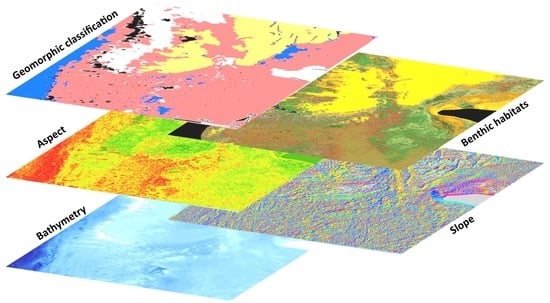
2.3. Image Classification

Benthic habitat classification included bottom reflectance, bathymetry, and first and second derivatives of bottom reflectance [17,18]. Despite the large size of the dataset (3° of latitudinal extent), a single set of spectral signatures was used for classification. This ensured a more automated approach and the possible application of image-retrieved signatures to future satellite-based hyperspectral sensors. Pixel-based classification using fuzzy logic was used to create a set of thematic classes. The final class assignment was organised in hierarchical tables with increasing levels of detail [17,18]. Benthic class labels incorporated the cover type name and percentage of that cover by each benthic component as determined in the field (Table S1 from Supplementary Materials). The ecological relevance of class names was also considered, focusing on the dominant biotic component. Look-up tables were created for joining raster outputs to the thematic legends at different hierarchical levels and thus allowed a different degree of detail to be displayed [17,18].

2.4. Topographic and Geomorphic Classifications

We used high resolution bathymetry extracted from the hyperspectral data in an object-based image classification to derive topographic classes for the Ningaloo Reef. We segmented the image prior to classification, thus combining pixels with similar values to form objects, which were then classified [38]. We also integrated the benthic classes with the topographic variables to create a geomorphic classification. All processing for the object-based image classification was run in an ENVI Feature Extraction environment.

2.5. Topographic Classification and Development of Ruleset

Terrain variables such as slope, aspect, and depth ranges were calculated in ENVI and used to define topographic classes. These variables were selected for their usefulness in characterising typical fringing reef features and classified into logical, knowledge-based classes. For example, an aspect ranging from 225–315° was labelled as facing west, a slope ranging from 30–90° as steep, and depths ranging from 0–5 m were classified as shallow (Table 1).
The spatial resolution of the retrieved bathymetry and the resultant slope and aspect data was identical to the original airborne data (3.5 m). As this was considered too fine a scale to map more extensive features such as lagoons or their slopes, the aspect and slope data were aggregated using a 9 m × 9 m (majority) filter. We applied a land mask, developed using NIR bands, as an additional input for the segmentation step.
We used the object segmentation scale of 10 (range was 0–100); thus, a relatively small object size could be created. The merging object scale was also set to 10 (scale 0–100). We used the logical operator AND to create all possible slope, depth, and aspect ranges combinations, calculated their attributes, and supervised classification to derive the final topographic variables raster. The logic of four quadrants of the compass, a threshold of 30° for a slope, and a 5 m threshold in the bathymetry were used to define 22 possible topographic classes (Table 1 and Table S2). These settings and, in particular, depth ranges, allowed for separating lagoonal and slope-based objects.

2.6. Geomorphic Classification and Development of Ruleset

In the geomorphic classification, we used the slope, aspect, depth, land mask, and the pixel-based habitat map. Depending on the focus area, we set the segmentation scale to 20 or 30 and the merging scale to 70 or 80, with no thresholding. Spatial, thematic, and textural object attributes were calculated during the ruleset development. In the absence of prior knowledge about object properties, several object spatial attributes were investigated and tested for their appropriateness in capturing features and spatial extent. All attributes were displayed as an image with objects fitting a specific range of parameters identifiable in different tones. This approach facilitated the efficient selection of suitable attributes and their parameters for each geomorphic class. Finally, the classes were described in the ruleset (Table S3), comparable in class descriptions to the previous mapping undertaken through aerial photo interpretation [15]. The object-based classification was performed using the defined ruleset applicable to the entire study area. Classified images were validated against a field dataset described in previously published work [17,18].

2.7. Validation

We performed validation of the pixel-based classification and, separately, an image-derived bathymetry. The pixel-based classification was validated using 185 points selected through random stratification by the classes to avoid oversampling abundant cover types such as sand. The geomorphic classification was validated using 124 different points to check the correspondence between the field data and geomorphic class labels. As there was an inherent geolocation error for the field locations, we used a buffer of 10 m around the field location to extract pixel labels. We used the majority rule to allocate the final class label.
Bathymetry was corrected for tide (Exmouth gauge) and validated against soundings from the WA Department of Transport (https://www.transport.wa.gov.au/imarine/marine-geographic-data.asp, accessed on 5 October 2021). As slope and aspect were derived from the bathymetry dataset, no separate validation was undertaken.

2.8. Comparison with Allen Atlas

We compared the results of our study to those available in the recently released Allen Atlas [10]. We downloaded data from the atlas for the three focal areas, created summaries of percentage areas mapped, and produced an overview of cover types mapped using the Allen Atlas benthic and geomorphic classifications. As the class definitions differed slightly from the current study and some classes were absent in our classification (e.g., rubble, rock, or seagrass), we indicated that in the final summary.

3. Results

3.1. Overview of Marine Habitat Distribution at the Ningaloo Reef

Using pixel-based classification along the Ningaloo Reef, we mapped an area of 761.7 km2 with 58.54 km2 (~8%) of coral mosaics, 390 km2 (~51%) of macroalgae mosaics, and 312 km2 (~41%) of pavement and sand. The continuous tabulate coral made up over a third of all corals. Just over 66% of coral mosaics were constituted of dense tabulate coral, sparse digitate coral, soft coral, and sparse sub-massive and massive corals. Continuous to patchy digitate and tabulate coral forms accounted for 10% of the coral cover, while “blue tip” Acropora was 8.5%. Most of the hard coral occurred as either very dense (>90%) cover or as patchy distribution (20–45%) (Figure 3).
Coral mosaics were well represented in most Ningaloo Marine Park sanctuary zones (IUCN Category II). Bateman sanctuary had the highest proportion of hard coral classes, followed by Murat, Mandu, and Maud (Figure 4). The smallest sanctuary zone, Lakeside, had the smallest area of coral (0.06%) (despite a few prominent coral bommies), with the majority being sand (92%). In contrast, Bundegi, Murat, and Tantabiddi sanctuary zones were dominated by macroalgae mosaics, while Turtles, Gnaraloo, and 3-Mile sanctuary zones had the largest proportion of limestone pavement (as mapped to the 20 m depth limit here).

3.2. Topographic Classification

The combination of bathymetry (depth) and its derivatives of slope and aspect resulted in a map for the Ningaloo Reef combining all three variables. Results for this topographic classification are illustrated here using three selected focus areas of Muiron Islands, Point Maud, and Gnaraloo Bay, representing northern, central, and southern sections of the fringing reef (Figure 5). As Ningaloo is a longitudinal fringing reef, westerly or easterly aspects dominated, although the high spatial resolution highlighted large areas with south-facing slopes. Point Maud had the largest proportion of the flat regions, whereas steep slopes characterised Gnaraloo Bay.
The topographic classification for the whole of the Ningaloo Reef resulted in a clear delineation of flat lagoons, mostly in shallow waters, steep slopes of channels, and some undulating surfaces. The three focus areas were different with respect to the dimensions of the lagoon, range of depths, slope, and aspect (Figure 6, Figure 7, Figure 8 and Figure 9). Figure 6 provides the legends that should be used to interpret Figure 7, Figure 8 and Figure 9.
The depth and aspect datasets and the final topographic classification clearly delineate the channel between the North and South Muiron Islands (Figure 7). Shallower waters and secondary channels in the SE of the area had wide sloping surfaces (300 m) facing east and west. Due to the channel’s north-south alignment, west-facing, gentle slopes in the shallow water made up 17.5% of the area, and west-facing, gentle slopes in the deep water, another 14%. The third and fourth largest areas were in the east and south-facing flat and shallow settings (12% each).
The Point Maud area had quite a varied reef structure, with the northern zones mapped as flat, with sandy plains and slopes (Figure 8). The Point Maud area had a large proportion of west-facing flat and deep areas (15%) and east and west-facing flat, shallow topographic settings (~13% each). An additional 21% of the area was classified as south-facing, gently sloping, shallow and deep areas.
Gnaraloo Bay (Figure 9) was characterised by a narrow and shallow lagoon and a large flat area adjacent to the shoreline. The reef pattern was more heterogeneous outside the shallow lagoon with higher ranges in slope and depth (due to the occurrence of large bommie-like structures). This area had a large proportion of westerly slopes, with equal proportions classified as gentle and deep, steep and deep, and gentle and shallow settings. There were also nearly equal areas of easterly slopes in the same depth and slope ranges (~30% of total).

3.3. Geomorphic Classification

We classified reef and lagoonal features of interest through the multi-scale, object-oriented classification. The ruleset based on topographic variables and habitat classification allowed the three different focus areas along the coast to be classified into five broad classes, three of which were coral dominated mosaics, and two were predominantly sand or pavement (Figure 10).
The Muiron Islands area was classified as a deep channel separating the two islands, shallow forereef, deep lagoonal environments, reef flats, and very shallow lagoonal settings. Both coral and algal communities were present in the channel between the two islands and on the slopes. Very little sand or limestone (<2%) was mapped in this focus area (Figure 10 and Figure 11).
The southern section of the Point Maud area had many small, round objects (coral bommies) and a relatively heterogeneous reef structure. In contrast, the northern section was more homogeneous and classified as flat sandy lagoons and some sand on slopes. The Point Maud area mainly consisted of coral and algal communities (backreef/shallow forereef and other shallow areas; 55%) and 15% consisted of forereef and deep lagoonal environments with coral and macroalgae mosaics. In the north and east of Point Maud, there were also a couple of extensive areas of flat lagoonal sand (Figure 10 and Figure 12).
Gnaraloo Bay (towards the south of the Ningaloo Reef) was mapped as a narrow and shallow lagoon with extensive flat sandy areas along the shoreline, becoming more heterogeneous outside of the shallow lagoon with larger differences in slope and depth because of the occurrence of large bommie-like structures. The two most extensive classes at Gnaraloo were coral and algal communities (deep forereef and other deep areas plus backreef/shallow forereef and other shallow areas; 52% combined) (Figure 10). The shallow coral communities on the reef flat can be seen in the western part of Figure 13, while nearshore sand in the shallow lagoons had a large contiguous distribution.

3.4. Validation

The bathymetry derived from airborne data had an overall 77% agreement with the Department of Transport echo-soundings and was considered acceptable for this study (Figure S1).
The overall accuracy of the pixel-based classification at the thematic generalisations level presented was 71.8% (Table S4, and for the geomorphic classification, 93.5%. User accuracy for the pixel-based classification ranged from 61–78% for the coral-dominated classes, 66–74% for the macroalgal communities, and 64–90% for the limestone pavement and sand environs. Unsurprisingly, as geomorphic classification grouped several narrower thematic classes, user accuracies were very high; between 90–96% for the coral-algal communities and 90–100% for the pavement and sand (Table S5).

3.5. Comparison with the Allen Atlas

Within the same study extent for each focus area, the current study mapped a higher proportion (20–50%) of the area than the Allen Atlas, as the hyperspectral sensor allowed mapping into deeper waters (Table 2). Surprisingly, the proportions of habitat classes were dissimilar. The hyperspectral sensor used in this study indicated a greater proportion of coral/algal classes than the Allen Atlas and, conversely, a smaller proportion of sand, rock, and rubble (Table 2). Interestingly, the Allen Atlas discerned some small areas of seagrass, although the hyperspectral study did not (only small seagrass drift samples and beach wrack were occasionally observed during field trips).

4. Discussion

This study showed that benthic cover and bathymetric features over a very extensive fringing reef could be successfully and consistently mapped using high resolution airborne hyperspectral remote sensing with operational methods. Our pixel-based classification mapped 46 benthic cover classes and provided statistics on the coral forms for the first time across the entire area of the Ningaloo Reef. Very few studies in the past have mapped such a large area, except now for the considerable effort through the global Allen Atlas [10].
In contrast with the previous benthic habitat map for Ningaloo, created through photointerpretation [15], our mapping captured a lot less coral cover and more macroalgae mosaics (8% vs. 51% within the study area), primarily due to the difference in the mapping methods [17]. We have characterised and enumerated cover by the different coral forms for the first time.
The use of hyperspectral data allowed mapping at the finer thematic resolution in benthic cover and simultaneous retrieval of bathymetry up to 20 m depth. Other coral reef studies have reported similar depth mapping limits (e.g., [18]).
Our approach of classifying the reef with the combined benthic cover, depth, slope, and aspect dataset highlights many areas along the reef with uniform cover types yet different topographic conditions (depth, slope, and aspect settings). On the other hand, some areas with uniform morphology may have a different benthic cover. The clear benefit of the method used in this study was that once created, the ruleset was transferable to the remainder of the reef without a need for additional modifications, thus making it more repeatable.
These two datasets, topographic and geomorphic, complement each other. As such datasets become more widely available at higher spatial resolutions, they will facilitate more marine ecology studies using landscape ecological theory, which are already well advanced in terrestrial systems [39]; they would also facilitate, for example, the evaluation of future threats to a reef (e.g., [28]).
Future satellite-based hyperspectral monitoring (e.g., EnMap) should allow similar feature discrimination, even at a coarser spatial resolution. However, allowing for bathymetry retrieval, current multispectral sensors have less capacity to resolve differences between coral and macroalgae mosaics [13,40].
The use of bathymetry in identifying areas with specific depth, aspect, slope characteristics, or rugosity is common in marine habitat investigations, especially for mesophotic regions such as a more recent investigation at Ningaloo [26] or in assessments of shallow reef resilience [28]. Water circulation can affect local conditions near the reef passes or shallow lagoons. Past events demonstrate that poor water circulation can result in mass coral mortalities (e.g., [2]). Thus, maps that identify these potentially vulnerable environments are helpful for scientists and managers.
Mapping topographic features is particularly relevant for the Ningaloo Reef because it is a fringing reef along the steep and narrow continental shelf and it experiences strong prevailing wind and waves. Bathymetric data and their derivatives have been previously used to describe the structural complexity of reefs (e.g., [26,41]). In this Ningaloo study, they enhance our understanding of the distribution of benthic cover, rather than just characterising the topographic settings or mapping rugosity. As seen from our focal areas, the topographic classification enhances the information available to ecologists and managers.
The advantage of our geomorphic maps is that they provide thematic generalisation across the benthic classes. Still, at the same time, they provide the context for the coral-algal mosaics; for example, shallow lagoonal or deeper areas. Because our classification incorporates topographic variables, it can more readily be compared (in areas of spatial overlap) with the studies which have characterised deeper regions of Ningaloo Reef using acoustic data and AUV imagery [42]. That study mapped the geomorphic variables through depth, curvature, aspect, rugosity, hypsometric, and bathymetric position indices. Other studies which have applied object-oriented classification (e.g., [43]) have also incorporated wind and wave model data into the classification process on the Great Barrier Reef.
Our approach of combining pixel-based marine habitat classification and object-based classification, incorporating topographic variables, allows for the processing of additional datasets and comparisons over time. Although the methods for the benthic classification in this study were focused on the coral cover, which is of particular interest to the managers for their monitoring programmes, data can be easily reprocessed to extract more detailed characterisation of other communities; for example, coralline encrusting algae or canopy algae such as Sargassum.
Although comparison with the Allen Atlas revealed broad similarities, there were also substantive discrepancies. In some aspects, Allen Atlas mapping used a different approach; their geomorphic maps also incorporated wave modelling and their benthic maps only presented dominant marine cover. It is likely that the differences, particularly in capturing the occurrence of coral, sand, or macroalgae, may be related to sensor differences and possibly also seasonal differences.
When capturing biomass changes in the macroalgal cover, seasonal differences must be considered [44]. The differences in biomass of some algal species at Ningaloo were as high as 18-fold over a 26 month study [45,46]. Data for our analysis were acquired during the early austral autumn, a period optimal for airborne surveys in the region, with very low wind, wave, and swell, and a minimum cloud cover. Imagery dates used for Allen Atlas mapping are unknown, so any further comparisons would need to consider this.
The presence of a separate seagrass category in the Allen Atlas, compared to our study, is surprising, as seagrasses are not common as extensive meadows in NMP. Nevertheless, a recent study [46] has noted that seagrass cover, although sparse, is higher in early summer; the study recommended monitoring seagrasses in the NW region of Australia between November to February. Over the years, there may have also been a change in benthic cover, as the region was impacted by a marine heatwave (2011–2012) and cyclones subsequent to our study [2].
Besides the obvious use of the marine habitat data in conservation planning, the topographic and geomorphic classifications have additional applications for managers. The results of this study could allow for monitoring by topographic or geomorphic variables to ensure that monitoring sites represent the full range of ecological settings in the park.
The topographic classification provides managers with the information required to locate and study biota that has specific requirements (e.g., slope, aspect, or depth range) or to stratify ecological sampling locations by these topographic variables; for example, the distribution of sea urchins [47] or grazing halos around coral bommies [48].
A future review of the protected area boundaries and level of protection status could incorporate our datasets to reflect reef resilience parameters such as those captured by our geomorphic classification [28]. Future changes, even small sea-level changes, are likely to affect water circulation in the shallow lagoons [49], and our data can be used in such modelling. If, as predicted, extreme weather events such as cyclones, storm surges, or marine heatwaves will be more common and severe [2,30,50,51], monitoring and reviewing the current protection of the Ningaloo Reef should be aided by our topographic and geomorphic classifications.

5. Conclusions

Hyperspectral sensors provide a timely, non-invasive and, compared to the field surveys, cost-effective approach to mapping and monitoring the extent and condition of reefs over large areas. This is because of their ability to identify reef components based on their spectral response. Processing of high-resolution hyperspectral data provided an efficient, operational approach to retrieving benthic cover, bathymetry, and subsequent topographic variables at the Ningaloo Reef. Object-based classification combined benthic cover with the topographic variables to create a geomorphic layer. Combining benthic habitat classes with topographic classification highlighted the value of processing the hyperspectral data for habitat and bathymetry in one seamless process. The ruleset developed for the Ningaloo Reef was demonstrated at three different focal areas (Muiron Islands, Point Maud, and Gnaraloo Bay) and allowed for consistent mapping of these seascapes. Through the use of examples, such classifications were demonstrated to potentially assist in the management and monitoring of the reef.

Supplementary Materials

The following supporting information can be downloaded at: https://www.mdpi.com/article/10.3390/rs14081827/s1, Table S1. Benthic cover types and their codes in field data of Ningaloo Reef based on [52]; Table S2. Definition of the ruleset and the class ranges using bathymetry data of Ningaloo Reef at the 9 × 9 majority kernel scale. (Slope (degrees), aspect (0–360 degrees) and bathymetry (cm)); Table S3. The ruleset for geomorphic classes was developed using topographic and habitat classes for the Ningaloo Reef. Area = the object area; tx_variance = the texture variance of the object; tx_entropy = the entropy of the object; maxSLOPE = the maximum value of the slope and so on. Some parameter/variable names refer to the properties of the objects and others to the slope or aspect or benthic class number; Table S4 Results of the validation of the pixel-based classification against the field data. Table S5 Results of the validation of the geomorphic classification against field data; Figure S1. Validation of the bathymetry dataset.

Author Contributions

Conceptualisation, H.T.K., K.W. and L.E.B.; methodology, H.T.K. and K.W.; validation, H.T.K., K.W. and L.E.B.; formal analysis, H.T.K. and K.W.; investigation, H.T.K., K.W. and L.E.B.; resources, H.T.K. and L.E.B.; data curation, K.W. and H.T.K.; writing—original draft preparation, H.T.K. and K.W.; writing—review and editing, H.T.K. and L.E.B.; visualisation, H.T.K. and K.W.; project administration, H.T.K.; funding acquisition, L.E.B. and H.T.K. All authors have read and agreed to the published version of the manuscript.

Funding

This research was funded by the CSIRO Wealth from Oceans programme, Australian Institute of Marine Science, and Murdoch University.

Informed Consent Statement

Not applicable.

Data Availability Statement

Links to publicly available data: https://ningaloo-atlas.org.au/content/ningaloo-collaboration-cluster-habitats-ningaloo-ree, accessed on 20 January 2022.

Acknowledgments

We thank the Department of Biodiversity, Conservation, and Attractions office staff in Exmouth and the regional rangers for advice and assistance with field accommodation.

Conflicts of Interest

The authors declare no conflict of interest. The funders had no role in the design of the study, in the collection, analyses, or interpretation of data, in the writing of the manuscript, or in the decision to publish the results.

References

  1. Spalding, M.D.; Ravilious, C.; Green, E.P. World Atlas of Coral Reefs; University of California Press: Berkeley, CA, USA, 2001. [Google Scholar]
  2. Vanderklift, M.A.; Babcock, R.; Barnes, P.B.; Cresswell, A.K.; Feng, M.; Haywood, M.D.E.; Holmes, T.H.; Lavery, P.S.; Pillans, R.D.; Smallwood, C.B.; et al. The oceanography and marine ecology of Ningaloo, a World Heritage Area. In Oceanography and Marine Biology, an Annual Review; Hawkins, S.J., Allcock, A.L., Bates, A.E., Evans, A.J., Firth, L.B., McQuaid, C.D., Russell, B.D., Smith, I.P., Swearer, S.E., Todd, P.A., Eds.; Taylor and Francis: Boca Raton, FL, USA, 2021; Volume 58, pp. 143–178. [Google Scholar]
  3. Wilson, B. Coral Reefs of the North West Shelf. In The Biogeography of the Australian North West Shelf; Wilson, B., Ed.; Elsevier: Boston, MA, USA, 2013; pp. 107–201. [Google Scholar]
  4. Collins, L.B.; Zhu, Z.R.; Wyrwoll, K.-H.; Eisenhauer, A. Late Quaternary structure and development of the northern Ningaloo Reef, Australia. Sediment. Geol. 2003, 159, 81–94. [Google Scholar] [CrossRef]
  5. CALM.; MPRA. Management Plan for the Ningaloo Marine Park and Muiron Islands Marine Management Area 2005–2015; Conservation and Land Management and Marine Parks and Reserves Authority, Government of Western Australia: Perth, Australia, 2005; p. 111.
  6. UNESCO. World Heritage Convention. Available online: http://whc.unesco.org/en/decisions/4278 (accessed on 20 January 2022).
  7. Mumby, P.J.; Green, E.P.; Edwards, A.J.; Clark, C.D. Cost-effectiveness of remote sensing for coastal management. In Remote Sensing Handbook for Tropical Coastal Management; Edwards, A.J., Ed.; UNESCO: Paris, France, 2000; p. 316. [Google Scholar]
  8. Purkis, S.J. Remote sensing tropical coral reefs: The view from above. Annu. Rev. Mar. Sci. 2018, 10, 149–168. [Google Scholar] [CrossRef] [PubMed]
  9. Foo, S.A.; Asner, G.P. Scaling up coral reef restoration using remote sensing technology. Front. Mar. Sci. 2019, 6, 79. [Google Scholar] [CrossRef] [Green Version]
  10. Allen Coral Atlas. Imagery, Maps and Monitoring of the World’s Tropical Coral Reefs. 2020. Available online: https://zenodo.org/record/3833246#.YlPOodNBxPY (accessed on 20 January 2022).
  11. Teague, J.; Megson-Smith, D.A.; Allen, M.J.; Day, J.C.C.; Scott, T.B. A review of current and new optical techniques for coral monitoring. Oceans 2022, 3, 30–45. [Google Scholar] [CrossRef]
  12. Green, E.P.; Mumby, P.; Edwards, A.J.; Clark, C.D. Remote Sensing for Tropical Coastal Management; UNESCO: Paris, France, 2000; p. 316. [Google Scholar]
  13. Hedley, J.; Roelfsema, C.; Chollett, I.; Harborne, A.; Heron, S.; Weeks, S.; Skirving, W.; Strong, A.; Eakin, C.; Christensen, T.; et al. Remote sensing of coral reefs for monitoring and management: A review. Remote Sens. 2016, 8, 118. [Google Scholar] [CrossRef] [Green Version]
  14. Asner, G.P.; Vaughn, N.R.; Heckler, J.; Knapp, D.E.; Balzotti, C.; Shafron, E.; Martin, R.E.; Neilson, B.J.; Gove, J.M. Large-scale mapping of live corals to guide reef conservation. Proc. Natl. Acad. Sci. USA 2020, 117, 33711–33718. [Google Scholar] [CrossRef]
  15. Bancroft, K.P.; Sheridan, M.W. The Major Marine Habitats of Ningaloo Marine Park and the Proposed Southern Extension; Marine Conservation Branch, Department of Conservation and Land Management: Perth, Australia, 2000; p. 35.
  16. Cassata, L.; Collins, L.B. Coral reef communities, habitats, and substrates in and near sanctuary zones of Ningaloo Marine Park. J. Coast. Res. 2008, 24, 139–151. [Google Scholar] [CrossRef] [Green Version]
  17. Kobryn, H.T.; Wouters, K.; Beckley, L.E. Habitats of the Ningaloo Reef and adjacent coastal areas determined through hyperspectral imagery. Ningaloo Collab. Clust. Final. Rep. 2011, 1b, 210. [Google Scholar]
  18. Kobryn, H.T.; Wouters, K.; Beckley, L.E.; Heege, T. Ningaloo Reef: Shallow marine habitats mapped using a hyperspectral sensor. PLoS ONE 2013, 8, e70105. [Google Scholar] [CrossRef] [Green Version]
  19. Kobryn, H.T.; Beckley, L.E.; Cramer, V.; Newsome, D. An assessment of coastal land cover and off-road vehicle tracks adjacent to Ningaloo Marine Park, north-western Australia. Ocean. Coast. Manag. 2017, 145, 94–105. [Google Scholar] [CrossRef]
  20. Hochberg, E.J.; Atkinson, M.J. Capabilities of remote sensors to classify coral, algae, and sand as pure and mixed spectra. Remote Sens. Environ. 2003, 85, 174–189. [Google Scholar] [CrossRef]
  21. Purkis, S. A ‘reef-up’ approach to classifying coral habitats from IKONOS imagery. IEEE Trans. Geosci. Remote Sens. 2005, 43, 1375–1390. [Google Scholar] [CrossRef]
  22. Mishra, D.R.; Narumalani, S.; Rundquist, D.; Lawson, M.; Perk, R. Enhancing the detection and classification of coral reef and associated benthic habitats: A hyperspectral remote sensing approach. J. Geophys. Res. 2007, 112, 1–18. [Google Scholar] [CrossRef] [Green Version]
  23. Mumby, P.J.; Edwards, A.J. Mapping marine environments with IKONOS imagery: Enhanced spatial resolution can deliver greater thematic accuracy. Remote Sens. Environ. 2002, 82, 248–257. [Google Scholar] [CrossRef]
  24. Andréfouët, S.; Zubia, M.; Payri, C. Mapping and biomass estimation of the invasive brown algae Turbinaria ornata (Turner) J. Agardh and Sargassum mangarevense (Grunow) Setchell on heterogeneous Tahitian coral reefs using 4-meter resolution IKONOS satellite data. Coral Reefs 2004, 23, 26. [Google Scholar] [CrossRef]
  25. Peneva, E.; Griffith, J.A.; Carter, G.A. Seagrass mapping in the Northern Gulf of Mexico using airborne hyperspectral imagery: A comparison of classification methods. J. Coast. Res. 2008, 24, 850–856. [Google Scholar] [CrossRef]
  26. Turner, J.A.; Babcock, R.C.; Hovey, R.; Kendrick, G.A. Can single classifiers be as useful as model ensembles to produce benthic seabed substratum maps? Estuar. Coast. Shelf Sci. 2018, 204, 149–163. [Google Scholar] [CrossRef]
  27. Lowe, R.J.; Pivan, X.; Falter, J.; Symonds, G.; Gruber, R. Rising sea levels will reduce extreme temperature variations in tide-dominated reef habitats. Sci. Adv. 2016, 2, e1600825. [Google Scholar] [CrossRef] [Green Version]
  28. Davies, H.N.; Beckley, L.E.; Kobryn, H.T.; Lombard, A.T.; Radford, B.; Heyward, A. Integrating climate change resilience features into the incremental refinement of an existing marine park. PLoS ONE 2016, 11, e0161094. [Google Scholar] [CrossRef] [Green Version]
  29. Smallwood, C.B.; Beckley, L.E.; Moore, S.A.; Kobryn, H.T. Assessing patterns of recreational use in large marine parks: A case study from Ningaloo Marine Park, Australia. Ocean. Coast. Manag. 2011, 54, 330–340. [Google Scholar] [CrossRef] [Green Version]
  30. Babcock, R.C.; Bustamante, R.H.; Fulton, E.A.; Fulton, D.J.; Haywood, M.D.E.; Hobday, A.J.; Kenyon, R.; Matear, R.J.; Plagányi, E.E.; Richardson, A.J.; et al. Severe continental-scale impacts of climate change are happening now: Extreme climate events impact marine habitat forming communities along 45% of Australia’s coast. Front. Mar. Sci. 2019, 6, 1–14. [Google Scholar] [CrossRef]
  31. Molony, B.W.; Thomson, D.P.; Feng, M. What can we learn from the 2010/11 Western Australian marine heatwave to better understand risks from the one forecast in 2020/21? Front. Mar. Sci. 2021, 8, 145. [Google Scholar] [CrossRef]
  32. Heege, T.; Fischer, J. Sun glitter correction in remote sensing imaging spectrometry. In Proceedings of the SPIE Ocean Optics XV, Monte Carlo, Monaco, 16–20 October 2000. [Google Scholar]
  33. Heege, T.; Häse, C.; Pinnel, N. Airborne multispectral remote sensing in shallow and deep waters. Backscatter 2003, 14, 17–19. [Google Scholar]
  34. Heege, T.; Fischer, J. Mapping of water constituents in Lake Constance using multispectral airborne scanner data and a physically based processing scheme. Can. J. Remote Sens. 2004, 30, 77–86. [Google Scholar] [CrossRef]
  35. Cerdeira-Estrada, S.; Heege, T.; Kolb, M.; Ohlendorf, S.; Uribe, A.; Muller, A.; Garza, R.; Ressl, R.; Aguirre, R.; Marino, I.; et al. Benthic habitat and bathymetry mapping of shallow waters in Puerto Morelos reefs using remote sensing with a physics based data processing. In Proceedings of the 2012 IEEE International, Geoscience and Remote Sensing Symposium (IGARSS), Munich, Germany, 22–27 July 2012; pp. 4383–4386. [Google Scholar]
  36. Ohlendorf, S.; Müller, A.; Heege, T.; Cerdeira-Estrada, S.; Kobryn, H.T. Bathymetry mapping and sea floor classification using multispectral satellite data and standardized physics-based data processing. In Proceedings of the SPIE 8175, Remote Sensing of the Ocean, Sea Ice, Coastal Waters, and Large Water Regions, Prague, Czech Republic, 19–22 September 2011; p. 817503. [Google Scholar] [CrossRef] [Green Version]
  37. McCoy, R.M. Field Methods in Remote Sensing; The Guilford Press: New York, NY, USA, 2005; p. 159. [Google Scholar]
  38. Lillesand, T.; Kiefer, R.W.; Chipman, J. Remote Sensing and Image Interpretation, 7th ed.; John Wiley & Sons, Inc.: Hoboken, NJ, USA, 2015. [Google Scholar]
  39. Kendall, M.S.; Miller, T. The influence of thematic and spatial resolution on maps of a coral reef ecosystem. Mar. Geod. 2008, 31, 75–102. [Google Scholar] [CrossRef]
  40. Roelfsema, C.M.; Lyons, M.B.; Castro-Sanguino, C.; Kovacs, E.M.; Callaghan, D.; Wettle, M.; Markey, K.; Borrego-Acevedo, R.; Tudman, P.; Roe, M.; et al. How Much Shallow Coral Habitat Is There on the Great Barrier Reef? Remote Sens. 2021, 13, 4343. [Google Scholar] [CrossRef]
  41. Mayorga-Martínez, M.; Bello-Pineda, J.; Perales-Valdivia, H.; Pérez-España, H.; Heyman, W.D. Characterizing geomorphology of mesophotic coral reef ecosystems in the southwestern Gulf of Mexico: Implications for conservation and management. Front. Mar. Sci. 2021, 8, 1–13. [Google Scholar] [CrossRef]
  42. Turner, J.A.; Babcock, R.C.; Hovey, R.; Kendrick, G.A. AUV-based classification of benthic communities of the Ningaloo shelf and mesophotic areas. Coral Reefs 2018, 37, 763–778. [Google Scholar] [CrossRef]
  43. Roelfsema, C.; Kovacs, E.; Ortiz, J.C.; Wolff, N.H.; Callaghan, D.; Wettle, M.; Ronan, M.; Hamylton, S.M.; Mumby, P.J.; Phinn, S. Coral reef habitat mapping: A combination of object-based image analysis and ecological modelling. Remote Sens. Environ. 2018, 208, 27–41. [Google Scholar] [CrossRef]
  44. Fulton, C.J.; Depczynski, M.; Holmes, T.H.; Noble, M.M.; Radford, B.; Wernberg, T.; Wilson, S.K. Sea temperature shapes seasonal fluctuations in seaweed biomass within the Ningaloo coral reef ecosystem. Limnol. Oceanogr. 2014, 59, 156–166. [Google Scholar] [CrossRef] [Green Version]
  45. Wilson, S.K.; Fulton, C.J.; Depczynski, M.; Holmes, T.H.; Noble, M.M.; Radford, B.; Tinkler, P. Seasonal changes in habitat structure underpin shifts in macroalgae-associated tropical fish communities. Mar. Biol. 2014, 161, 2597–2607. [Google Scholar] [CrossRef]
  46. Vanderklift, M.A.; Berham, D.; Haywood, M.; Lozano-Montes, H.M.; McCallum, R.; McLaughlin, J.; McMahon, K.; Mortimer, N.; Lavery, P.S. Natural Dynamics: Understanding Natural Dynamics of Seagrasses of the North West of Western Australia; Western Australian Marine Science Institution: Perth, Australia, 2017; p. 55. [Google Scholar]
  47. Westlake, E.L.; Bessey, C.; Fisher, R.; Thomson, D.P.; Haywood, M.D.E. Environmental factors and predator abundance predict the distribution and occurrence of two sympatric urchin species at Ningaloo Reef, Western Australia. Mar. Freshw. Res. 2021, 72, 1711–1721. [Google Scholar] [CrossRef]
  48. Downie, R.A.; Babcock, R.C.; Thomson, D.P.; Vanderklift, M.A. Density of herbivorous fish and intensity of herbivory are influenced by proximity to coral reefs. Mar. Ecol. Prog. Ser. 2013, 482, 217–225. [Google Scholar] [CrossRef] [Green Version]
  49. Taebi, S.; Lowe, R.J.; Pattiaratchi, C.B.; Ivey, G.N.; Symonds, G.; Brinkman, R. Nearshore circulation in a tropical fringing reef system. J. Geophys. Res. Ocean. 2011, 116, 1–15. [Google Scholar] [CrossRef]
  50. Moore, J.A.Y.; Bellchambers, L.M.; Depczynski, M.R.; Evans, R.D.; Evans, S.N.; Field, S.N.; Friedman, K.J.; Gilmour, J.P.; Holmes, T.H.; Middlebrook, R.; et al. Unprecedented Mass Bleaching and Loss of Coral across 12° of Latitude in Western Australia in 2010–11. PLoS ONE 2012, 7, e51807. [Google Scholar] [CrossRef] [Green Version]
  51. Gilmour, J.P.; Cook, K.L.; Ryan, N.M.; Puotinen, M.L.; Green, R.H.; Shedrawi, G.; Hobbs, J.-P.A.; Thomson, D.P.; Babcock, R.C.; Buckee, J.; et al. The state of Western Australia’s coral reefs. Coral Reefs 2019, 38, 651–667. [Google Scholar] [CrossRef]
  52. Jonker, M.; Johns, K.; Osborne, K. Surveys of benthic reef communities using underwater digital photography and counts of juvenile corals. In Long-Term Monitoring of the Great Barrier Reef Standard Operation Procedure, No 10; Australian Institute of Marine Science: Townsville, Australia, 2008; p. 85. [Google Scholar]
Figure 1. The extent of the HyMap airborne survey, location of the three focus areas and management zones (state waters) over the Ningaloo Reef in Western Australia. The abbreviation of ‘SZ ‘with a place label refers to a sanctuary zone.
Remotesensing 14 01827 g001
Figure 2. Summary of data processing steps used for the airborne hyperspectral survey at the Ningaloo Reef.
Remotesensing 14 01827 g002
Figure 3. Summary of coral mosaics within the Ningaloo Reef study area (<20 m depth) and in sanctuary zones. Data are sorted by the area covered from largest to smallest for the top 10 classes, accounting for 97% of the total coral cover.
Remotesensing 14 01827 g003
Figure 4. Overview of the main benthic classes for all mapped sanctuary zones. Data are arranged north to south along the Ningaloo Reef coast, and the locations are indicated in Figure 1. Some of these zones extend into deeper waters, thus beyond this study’s 20 m depth range.
Remotesensing 14 01827 g004
Figure 5. Area (hectares) of all possible topographic classes in the three focus areas along the Ningaloo Reef.
Remotesensing 14 01827 g005
Figure 6. Legends for depth, aspect, slope, and final topographic classes at the Ningaloo Reef. This legend applies to Figure 7, Figure 8 and Figure 9.
Remotesensing 14 01827 g006
Figure 7. Topographic variables for the focus area at Muiron Islands at the northern extent of the Ningaloo Reef. (a) depth, (b) aspect, (c) slope, and (d) topographic classification. Legends in Figure 6 apply.
Remotesensing 14 01827 g007
Figure 8. Topographic variables for the focus area at Point Maud, central the Ningaloo Reef. (a) depth, (b) aspect, (c) slope, and (d) topographic classification. Legends in Figure 6 apply.
Remotesensing 14 01827 g008
Figure 9. Topographic variables for the focus area at Gnaraloo Bay at the southern end of the Ningaloo Reef. (a) depth, (b) aspect, (c) slope, and (d) topographic classification. Legends in Figure 6 apply.
Remotesensing 14 01827 g009
Figure 10. Summary of areas (ha) of geomorphic classes mapped within the three focus areas along the Ningaloo Reef.
Remotesensing 14 01827 g010
Figure 11. Muiron Islands area (a) subsurface reflectance, (b) pixel-based benthic habitat map and (c) geomorphic classes for the same area.
Remotesensing 14 01827 g011
Figure 12. Point Maud area (north of Coral Bay) (a) subsurface reflectance, (b) pixel-based benthic habitat map, and (c) geomorphic classes.
Remotesensing 14 01827 g012
Figure 13. Gnaraloo Bay area (a) subsurface reflectance, (b) pixel-based benthic habitat map, and (c) geomorphic classes.
Remotesensing 14 01827 g013
Table 1. Ranges of variables for aspect, slope, and depth to define topographic parameters for the Ningaloo Reef.
NameDescription
East facingAspect: 45–135°
North facingAspect: 315–360° and 0–45°
South facingAspect: 135–225°
West facingAspect: 225–315°
FlatSlope: 0–30°
SteepSlope: 30–90°
ShallowDepth: 0–5 m
DeepDepth > 5 m
Table 2. Comparison between the current hyperspectral study and data from the Allen Atlas (ha).
CategoryMuiron IslandsPoint MaudGnaraloo Bay
This StudyAllen AtlasThis StudyAllen AtlasThis StudyAllen Atlas
Coral/algae629.0192.3898.6326.0623.4162.5
Sand + rock + rubble13.124.5148.6310.945.090.9
Seagrass0.01.10.05.60.029.5
Total area mapped *642.08262.201047.14809.80668.41330.69
* Numbers in italics refer to the same spatial extent within each study area.
Publisher’s Note: MDPI stays neutral with regard to jurisdictional claims in published maps and institutional affiliations.

