
Beached and Floating Litter Surveys by Unmanned Aerial Vehicles: Operational Analogies and Differences

 , , , and
Abstract
: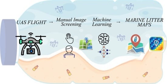
1. Introduction
2. Flight Planning and Deployment
2.1. Beached and Floating Litter Survey Experiences with Unmanned Aerial Vehicles

| Reference | Survey | Site | Drone Model | Camera Resolution (px) | Flight Height (m) | Ground Sampling Distance (cm/pixel) | Area Extent (km2) |
|---|---|---|---|---|---|---|---|
| [25] | BL | Cabedelo (PT) | DJI Phantom 4 Pro | 4864 × 3648 | 20 | 0.55 | 0.020 |
| [26] | BL | Leirosa (PT) | DJI Phantom 4 RTK | 5472 × 3648 | 30–40 | 0.9–1 | 0.023 |
| [31,32] | BL | Quiaios (PT) | DJI Matrix 210 RTK V2 | 4000 × 3000 | 40 | 1.2 | 0.016 |
| [33,34] | FL | Cap de Creus (ES) | DJI Phantom 3 Pro | 4000 × 3000 | 45 | 2 | 1.1 |
| [34] | FL | Blanes (ES) | Multi-rotor Topografia | 7952 × 5304 | 20–120 | 0.6–3.6 | 1.9 |
| [33] | FL | Barcelona (ES) | DJI Phantom 3 Pro | 4000 × 3000 | 45 | 2 | 7.9 |
| [33,34] | FL | Delta de l’Ebre (ES) | DJI Mavic Pro | 4000 × 3000 | 65 | 2 | 3.5 |
2.2. Environmental Constraints
3. Image Products and Analysis
3.1. Manual Image Screening
3.2. Machine Learning and Automated Detection
| Reference | Method | Type of Litter | Binary Approach | UAV Flight Altitude (GSD) | |||
|---|---|---|---|---|---|---|---|
| P (%) | R (%) | F-Score (%) | |||||
| [25] | RF | Px | BL | 73 | 74 | 75 | 20 m (0.55 cm/pixel) |
| [44,46] | RF | Px | BL | 70 | 71 | 70 | 20 m (0.55 cm/pixel) |
| CNN | 55 | 65 | 60 | ||||
| [50] | RF | Ob | BL | 75 | 68 | 72 | 20 m (0.55 cm/pixel) |
| SVM | Ob | 76 | 62 | 68 | |||
| KNN | Ob | 68 | 62 | 65 | |||
| [33] | CNN | Px | FL | 79 | 94 | 86 | 20–120 m (0.6–3.6 cm/pixel) |
| [45] | NN | Px | BL | 80 | 67 | 73 | 30 m (0.9 cm/pixel) |
4. Discussion
5. Conclusions
Author Contributions
Funding
Data Availability Statement
Acknowledgments
Conflicts of Interest
References
- Bergmann, M.; Gutow, L.; Klages, M. Marine Anthropogenic Litter; Springer Nature: Berlin, Germany, 2015; ISBN 9783319165103. [Google Scholar]
- Galgani, F. Marine Litter, Future Prospects for Research. Front. Mar. Sci. 2015, 2, 87. [Google Scholar] [CrossRef] [Green Version]
- Jambeck, J.R.; Geyer, R.; Wilcox, C.; Siegler, T.R.; Perryman, M.; Andrady, A.; Narayan, R.; Law, K.L. Plastic Waste Inputs from Land into the Ocean. Science 2015, 347, 768–771. [Google Scholar] [CrossRef] [PubMed]
- Galgani, F.; Brien, A.S.-O.; Weis, J.; Ioakeimidis, C.; Schuyler, Q.; Makarenko, I.; Griffiths, H.; Bondareff, J.; Vethaak, D.; Deidun, A.; et al. Are Litter, Plastic and Microplastic Quantities Increasing in the Ocean? Microplast. Nanoplast. 2021, 1, 2. [Google Scholar] [CrossRef]
- Meijer, L.J.J.; van Emmerik, T.; van der Ent, R.; Schmidt, C.; Lebreton, L. More Than 1000 Rivers Account for 80% of Global Riverine Plastic Emissions into the Ocean. Sci. Adv. 2021, 7, eaaz5803. [Google Scholar] [CrossRef] [PubMed]
- Schwarz, A.; Ligthart, T.; Boukris, E.; van Harmelen, T. Sources, Transport, and Accumulation of Different Types of Plastic Litter in Aquatic Environments: A Review Study. Mar. Pollut. Bull. 2019, 143, 92–100. [Google Scholar] [CrossRef] [PubMed]
- Murray, C.C.; Maximenko, N.; Lippiatt, S. The Influx of Marine Debris from the Great Japan Tsunami of 2011 to North American Shorelines. Mar. Pollut. Bull. 2018, 132, 26–32. [Google Scholar] [CrossRef]
- Andriolo, U.; Gonçalves, G. Is Coastal Erosion a Source of Marine Litter Pollution? Evidence of Coastal Dunes Being a Reservoir of Plastics. Mar. Pollut. Bull. 2022, 174, 113307. [Google Scholar] [CrossRef]
- Veiga, J.M.; Fleet, D.; Kinsey, S.; Nilsson, P.; Vlachogianni, T.; Werner, S.; Galgani, F.; Thompson, R.C.; Dagevos, J.; Gago, J.; et al. Identifying Sources of Marine Litter; European Comission: Brussels, Belgium, 2016. [Google Scholar]
- Maximenko, N.; Corradi, P.; Law, K.L.; Van Sebille, E.; Garaba, S.P.; Lampitt, R.S.; Galgani, F.; Martinez-Vicente, V.; Goddijn-Murphy, L.; Veiga, J.M.; et al. Toward the Integrated Marine Debris Observing System. Front. Mar. Sci. 2019, 6, 6. [Google Scholar] [CrossRef] [Green Version]
- Martínez-Vicente, V.; Clark, J.R.; Corradi, P.; Aliani, S.; Arias, M.; Bochow, M.; Bonnery, G.; Cole, M.; Cózar, A.; Donnelly, R.; et al. Measuring Marine Plastic Debris from Space: Initial Assessment of Observation Requirements. Remote Sens. 2019, 11, 2443. [Google Scholar] [CrossRef] [Green Version]
- Salgado-Hernanz, P.M.; Bauzà, J.; Alomar, C.; Compa, M.; Romero, L.; Deudero, S. Assessment of Marine Litter through Remote Sensing: Recent Approaches and Future Goals. Mar. Pollut. Bull. 2021, 168, 112347. [Google Scholar] [CrossRef]
- Kako, S.; Isobe, A.; Magome, S. Low Altitude Remote-Sensing Method to Monitor Marine and Beach Litter of Various Colors Using a Balloon Equipped with a Digital Camera. Mar. Pollut. Bull. 2012, 64, 1156–1162. [Google Scholar] [CrossRef] [PubMed]
- Nakashima, E.; Isobe, A.; Magome, S.; Kako, S.; Deki, N. Using Aerial Photography and in Situ Measurements to Estimate the Quantity of Macro-Litter on Beaches. Mar. Pollut. Bull. 2011, 62, 762–769. [Google Scholar] [CrossRef] [PubMed]
- Garcia-Garin, O.; Aguilar, A.; Borrell, A.; Gozalbes, P.; Lobo, A.; Penadés-Suay, J.; Raga, J.A.; Revuelta, O.; Serrano, M.; Vighi, M. Who’s Better at Spotting? A Comparison Between Aerial Photography and Observer-Based Methods to Monitor Floating Marine Litter and Marine Mega-Fauna. Environ. Pollut. 2020, 258, 113680. [Google Scholar] [CrossRef] [PubMed]
- Freitas, S.; Silva, H.; Silva, E. Remote Hyperspectral Imaging Acquisition and Characterization for Marine Litter Detection. Remote Sens. 2021, 13, 2536. [Google Scholar] [CrossRef]
- Themistocleous, K.; Papoutsa, C.; Michaelides, S.; Hadjimitsis, D. Investigating Detection of Floating Plastic Litter from Space Using Sentinel-2 Imagery. Remote Sens. 2020, 12, 2648. [Google Scholar] [CrossRef]
- Topouzelis, K.; Papakonstantinou, A.; Garaba, S.P. Detection of Floating Plastics from Satellite and Unmanned Aerial Systems (Plastic Litter Project 2018). Int. J. Appl. Earth Obs. Geoinf. 2019, 79, 175–183. [Google Scholar] [CrossRef]
- Biermann, L.; Clewley, D.; Martinez-Vicente, V.; Topouzelis, K. Finding Plastic Patches in Coastal Waters Using Optical Satellite Data. Sci. Rep. 2020, 10, 5364. [Google Scholar] [CrossRef] [Green Version]
- Manfreda, S.; McCabe, M.F.; Miller, P.E.; Lucas, R.; Madrigal, V.P.; Mallinis, G.; Ben Dor, E.; Helman, D.; Estes, L.; Ciraolo, G.; et al. On the Use of Unmanned Aerial Systems for Environmental Monitoring. Remote Sens. 2018, 10, 641. [Google Scholar] [CrossRef] [Green Version]
- Tmušić, G.; Manfreda, S.; Aasen, H.; James, M.R.; Gonçalves, G.; Ben-Dor, E.; Brook, A.; Polinova, M.; Arranz, J.J.; Mészáros, J.; et al. Current Practices in UAS-Based Environmental Monitoring. Remote Sens. 2020, 12, 1001. [Google Scholar] [CrossRef] [Green Version]
- Martin, C.; Zhang, Q.; Zhai, D.; Zhang, X.; Duarte, C.M. Enabling a Large-Scale Assessment of Litter Along Saudi Arabian Red Sea Shores by Combining Drones and Machine Learning. Environ. Pollut. 2021, 277, 116730. [Google Scholar] [CrossRef]
- Deidun, A.; Gauci, A.; Lagorio, S.; Galgani, F. Optimising Beached Litter Monitoring Protocols through Aerial Imagery. Mar. Pollut. Bull. 2018, 131, 212–217. [Google Scholar] [CrossRef] [PubMed]
- Merlino, S.; Paterni, M.; Berton, A.; Massetti, L. Unmanned Aerial Vehicles for Debris Survey in Coastal Areas: Long-Term Monitoring Programme to Study Spatial and Temporal Accumulation of the Dynamics of Beached Marine Litter. Remote Sens. 2020, 12, 1260. [Google Scholar] [CrossRef] [Green Version]
- Gonçalves, G.; Andriolo, U.; Pinto, L.; Bessa, F. Mapping Marine Litter Using UAS on a Beach-Dune System: A Multidisciplinary Approach. Sci. Total Environ. 2020, 706, 135742. [Google Scholar] [CrossRef] [PubMed]
- Andriolo, U.; Gonçalves, G.; Sobral, P.; Fontán-Bouzas, A.; Bessa, F. Beach-Dune Morphodynamics and Marine Macro-Litter Abundance: An Integrated Approach with Unmanned Aerial System. Sci. Total Environ. 2020, 749, 141474. [Google Scholar] [CrossRef]
- Taddia, Y.; Corbau, C.; Buoninsegni, J.; Simeoni, U.; Pellegrinelli, A. UAV Approach for Detecting Plastic Marine Debris on the Beach: A Case Study in the Po River Delta (Italy). Drones 2021, 5, 140. [Google Scholar] [CrossRef]
- Escobar-Sánchez, G.; Haseler, M.; Oppelt, N.; Schernewski, G. Efficiency of Aerial Drones for Macrolitter Monitoring on Baltic Sea Beaches. Front. Environ. Sci. 2021, 8, 560237. [Google Scholar] [CrossRef]
- Papakonstantinou, A.; Topouzelis, K.; Doukari, M.; Andreadis, O. Mapping Refugee Litters in the Eastern Coast of Lesvos Using UAS, an Emerging Marine Litter Problem. Abstr. ICA 2019, 1, 1–2. [Google Scholar] [CrossRef] [Green Version]
- Papakonstantinou, A.; Batsaris, M.; Spondylidis, S.; Topouzelis, K. A Citizen Science Unmanned Aerial System Data Acquisition Protocol and Deep Learning Techniques for the Automatic Detection and Mapping of Marine Litter Concentrations in the Coastal Zone. Drones 2021, 5, 6. [Google Scholar] [CrossRef]
- Andriolo, U.; Gonçalves, G.; Bessa, F.; Sobral, P. Mapping Marine Litter on Coastal Dunes with Unmanned Aerial Systems: A Showcase on the Atlantic Coast. Sci. Total Environ. 2020, 736, 139632. [Google Scholar] [CrossRef]
- Andriolo, U.; Gonçalves, G.; Sobral, P.; Bessa, F. Spatial and Size Distribution of Macro-Litter on Coastal Dunes from Drone Images: A Case Study on the Atlantic Coast. Mar. Pollut. Bull. 2021, 169, 112490. [Google Scholar] [CrossRef]
- Garcia-Garin, O.; Monleón-Getino, T.; López-Brosa, P.; Borrell, A.; Aguilar, A.; Borja-Robalino, R.; Cardona, L.; Vighi, M. Automatic Detection and Quantification of Floating Marine Macro-Litter in Aerial Images: Introducing a Novel Deep Learning Approach Connected to a Web Application in R. Environ. Pollut. 2021, 273, 116490. [Google Scholar] [CrossRef] [PubMed]
- Garcia-Garin, O.; Borrell, A.; Aguilar, A.; Cardona, L.; Vighi, M. Floating Marine Macro-Litter in the North Western Mediterranean Sea: Results from a Combined Monitoring Approach. Mar. Pollut. Bull. 2020, 159, 111467. [Google Scholar] [CrossRef] [PubMed]
- Geraeds, M.; Van Emmerik, T.; De Vries, R.; Bin Ab Razak, M.S. Riverine Plastic Litter Monitoring Using Unmanned Aerial Vehicles (UAVs). Remote Sens. 2019, 11, 2045. [Google Scholar] [CrossRef] [Green Version]
- Portz, L.; Portantiolo, R.; Villate-Daza, D.A.; Fontán-Bouzas, Á. Science of the Total Environment Where Does Marine Litter Hide? The Providencia and Santa Catalina Island Problem, Seaflower Reserve (Colombia). Sci. Total Environ. 2021, 813, 151878. [Google Scholar] [CrossRef] [PubMed]
- Merlino, S.; Locritani, M.; Stroobant, M.; Mioni, E.; Tosi, D. SeaCleaner: Focusing Citizen Science and Environment Education on Unraveling the Marine Litter Problem. Mar. Technol. Soc. J. 2015, 49, 99–118. [Google Scholar] [CrossRef]
- Colefax, A.P.; Butcher, P.A.; Kelaher, B.P. The Potential for Unmanned Aerial Vehicles (UAVs) to Conduct Marine Fauna Surveys in Place of Manned Aircraft. ICES J. Mar. Sci. 2018, 75, 1–8. [Google Scholar] [CrossRef]
- Gonçalves, G.; Gonçalves, D.; Gómez-Gutiérrez, Á.; Andriolo, U.; Pérez-alvárez, J.A. 3d Reconstruction of Coastal Cliffs from Fixed-Wing and Multi-Rotor Uas: Impact of Sfm-Mvs Processing Parameters, Image Redundancy and Acquisition Geometry. Remote Sens. 2021, 13, 1222. [Google Scholar] [CrossRef]
- Andriolo, U.; Gonçalves, G.; Rangel-Buitrago, N.; Paterni, M.; Bessa, F.; Gonçalves, L.M.; Sobral, P.; Bini, M.; Duarte, D.; Fontán-Bouzas, A.; et al. Drones for Litter Mapping: An Inter-Operator Concordance Test in Marking Beached Items on Aerial Images. Mar. Pollut. Bull. 2021, 169, 112542. [Google Scholar] [CrossRef]
- Galgani, F.; Hanke, G.; Werner, S.; De Vrees, L. Marine Litter within the European Marine Strategy Framework Directive. ICES J. Mar. Sci. 2013, 70, 1055–1064. [Google Scholar] [CrossRef]
- Lo, H.-S.; Wong, L.-C.; Kwok, S.-H.; Lee, Y.-K.; Po, B.H.-K.; Wong, C.-Y.; Tam, N.F.-Y.; Cheung, S.-G. Field Test of Beach Litter Assessment by Commercial Aerial Drone. Mar. Pollut. Bull. 2020, 151, 110823. [Google Scholar] [CrossRef]
- Merlino, S.; Paterni, M.; Locritani, M.; Andriolo, U.; Gonçalves, G.; Massetti, L. Citizen Science for Marine Litter Detection and Classification on Unmanned Aerial Vehicle Images. Water 2021, 13, 3349. [Google Scholar] [CrossRef]
- Duarte, D.; Andriolo, U.; Gonçalves, G. Addressing the Class Imbalance Problem in The Automatic Image Classification Of Coastal Litter From Orthophotos Derived From Uas Imagery. ISPRS Ann. Photogramm. Remote Sens. Spat. Inf. Sci. 2020, 3, 439–445. [Google Scholar] [CrossRef]
- Pinto, L.; Andriolo, U.; Gonçalves, G. Detecting Stranded Macro-Litter Categories on Drone Orthophoto by a Multi-Class Neural Network. Mar. Pollut. Bull. 2021, 169, 112594. [Google Scholar] [CrossRef] [PubMed]
- Gonçalves, G.; Andriolo, U.; Pinto, L.; Duarte, D. Mapping Marine Litter with Unmanned Aerial Systems: A Showcase Comparison Among Manual Image Screening and Machine Learning Techniques. Mar. Pollut. Bull. 2020, 155, 111158. [Google Scholar] [CrossRef] [PubMed]
- R Core Development Team. A Language and Environment for Statistical Computing; R Foundation for Statistical Computing: Vienna, Austria, 2020; Volume 2, Available online: https://www.R-project.org.
- RStudio, I. Shiny: Web Application Framework for R. R Packag. 2013, 1, 2017. [Google Scholar]
- Fallati, L.; Polidori, A.; Salvatore, C.; Saponari, L.; Savini, A.; Galli, P. Anthropogenic Marine Debris Assessment with Unmanned Aerial Vehicle Imagery and Deep Learning: A Case Study Along the Beaches of the Republic of Maldives. Sci. Total Environ. 2019, 693, 133581. [Google Scholar] [CrossRef] [PubMed]
- Gonçalves, G.; Andriolo, U.; Gonçalves, L.; Sobral, P.; Bessa, F. Quantifying Marine Macro Litter Abundance on a Sandy Beach Using Unmanned Aerial Systems and Object-Oriented Machine Learning Methods. Remote Sens. 2020, 12, 2599. [Google Scholar] [CrossRef]
- Battisti, C.; Poeta, G.; Romiti, F.; Picciolo, L. Small Environmental Actions Need of Problem-Solving Approach: Applying Project Management Tools to Beach Litter Clean-Ups. Environments 2020, 7, 87. [Google Scholar] [CrossRef]
- Williams, A.T.; Rangel-Buitrago, N.G.; Anfuso, G.; Cervantes, O.; Botero, C.M. Litter Impacts on Scenery and Tourism on the Colombian North Caribbean Coast. Tour. Manag. 2016, 55, 209–224. [Google Scholar] [CrossRef]
- Gonçalves, G.; Andriolo, U. Operational Use of Multispectral Images for Macro-Litter Mapping and Categorization by Unmanned Aerial Vehicle. Mar. Pollut. Bull. 2022, 176, 113431. [Google Scholar] [CrossRef]
- Locritani, M.; Merlino, S.; Abbate, M. Assessing the Citizen Science Approach as Tool to Increase Awareness on the Marine Litter Problem. Mar. Pollut. Bull. 2019, 140, 320–329. [Google Scholar] [CrossRef] [PubMed]
- Turner, I.L.; Harley, M.; Drummond, C.D. UAVs for Coastal Surveying. Coast. Eng. 2016, 114, 19–24. [Google Scholar] [CrossRef]
- Luppichini, M.; Bini, M.; Paterni, M.; Berton, A.; Merlino, S. A New Beach Topography-Based Method for Shoreline Identification. Water 2020, 12, 3110. [Google Scholar] [CrossRef]
- Duo, E.; Trembanis, A.C.; Dohner, S.; Grottoli, E.; Ciavola, P. Local-Scale Post-Event Assessments with GPS and UAV-Based Quick-Response Surveys: A Pilot Case from the Emilia–Romagna (Italy) Coast. Nat. Hazards Earth Syst. Sci. 2018, 18, 2969–2989. [Google Scholar] [CrossRef] [Green Version]
- Santos, C.J.; Andriolo, U.; Ferreira, J.C. Shoreline Response to a Sandy Nourishment in a Wave-Dominated Coast Using Video Monitoring. Water 2020, 12, 1632. [Google Scholar] [CrossRef]
- Fontán-Bouzas, A.; Alcántara-Carrió, J.; Albarracín, S.; Baptista, P.; Silva, P.A.; Portz, L.; Manzolli, R.P. Multiannual Shore Morphodynamics of a Cuspate Foreland: Maspalomas (Gran Canaria, Canary Islands). J. Mar. Sci. Eng. 2019, 7, 416. [Google Scholar] [CrossRef] [Green Version]
- Duo, E.; Fabbri, S.; Grottoli, E.; Ciavola, P. Uncertainty of Drone-Derived DEMs and Significance of Detected Morphodynamics in Artificially Scraped Dunes. Remote Sens. 2021, 13, 1823. [Google Scholar] [CrossRef]
- Fairley, I.; Horrillo-Caraballo, J.; Masters, I.; Karunarathna, H.; Reeve, D. Spatial Variation in Coastal Dune Evolution in a High Tidal Range Environment. Remote Sens. 2020, 12, 3689. [Google Scholar] [CrossRef]
- Gómez-Gutiérrez, Á.; Gonçalves, G.R. Surveying Coastal Cliffs Using Two UAV Platforms (multi-Rotor and Fixed- Wing) and Three Different Approaches for the Estimation of Volumetric Changes. Int. J. Remote Sens. 2020, 41, 8143–8175. [Google Scholar] [CrossRef]
- Laporte-Fauret, Q.; Lubac, B.; Castelle, B.; Michalet, R.; Marieu, V.; Bombrun, L.; Launeau, P.; Giraud, M.; Normandin, C.; Rosebery, D. Classification of Atlantic Coastal Sand Dune Vegetation Using In Situ, UAV, and Airborne Hyperspectral Data. Remote Sens. 2020, 12, 2222. [Google Scholar] [CrossRef]
- Fabbri, S.; Grottoli, E.; Armaroli, C.; Ciavola, P. Using High-Spatial Resolution UAV-Derived Data to Evaluate Vegetation and Geomorphological Changes on a Dune Field Involved in a Restoration Endeavour. Remote Sens. 2021, 13, 1987. [Google Scholar] [CrossRef]
- Raoult, V.; Colefax, A.P.; Allan, B.M.; Cagnazzi, D.; Castelblanco-Martínez, N.; Ierodiaconou, D.; Johnston, D.W.; Landeo-Yauri, S.; Lyons, M.; Pirotta, V.; et al. Operational Protocols for the Use of Drones in Marine Animal Research. Drones 2020, 4, 64. [Google Scholar] [CrossRef]
- Nunes, L.; Pereira, T.; Nascimento, X.; Shah, Y.; Luciano, P. Comparing Photography and Collection Methods to Sample Litter in Seabird Nests in a Coastal Archipelago in the Southwest Atlantic. Mar. Pollut. Bull. 2022, 175, 113357. [Google Scholar]
- Fidai, Y.A.; Dash, J.; Tompkins, E.; Tonon, T. A Systematic Review of Floating and Beach Landing Records of Sargassum Beyond the Sargasso Sea. Environ. Res. Commun. 2020, 2, 122001. [Google Scholar] [CrossRef]
- Valentini, N.; Balouin, Y. Assessment of a Smartphone-Based Camera System for Coastal Image Segmentation and Sargassum Monitoring. J. Mar. Sci. Eng. 2020, 8, 23. [Google Scholar] [CrossRef] [Green Version]
- Hamad, I.Y.; Staehr, P.A.U.; Rasmussen, M.B.; Sheikh, M. Drone-Based Characterization of Seagrass Habitats in the Tropical Waters of Zanzibar. Remote Sens. 2022, 14, 680. [Google Scholar] [CrossRef]
- Kandrot, S.; Hayes, S.; Holloway, P. Applications of Uncrewed Aerial Vehicles (UAV) Technology to Support Integrated Coastal Zone Management and the UN Sustainable Development Goals at the Coast. Estuaries Coasts 2021, 1–20. [Google Scholar] [CrossRef] [PubMed]
- Adade, R.; Aibinu, A.M.; Ekumah, B.; Asaana, J. Unmanned Aerial Vehicle (UAV) Applications in Coastal Zone management—A Review. Environ. Monit. Assess. 2021, 193, 154. [Google Scholar] [CrossRef] [PubMed]
- López, J.J.; Mulero-Pázmány, M. Drones for Conservation in Protected Areas: Present and Future. Drones 2019, 3, 10. [Google Scholar] [CrossRef] [Green Version]
- Jiao, Z.; Jia, G.; Cai, Y. A New Approach to Oil Spill Detection That Combines Deep Learning with Unmanned Aerial Vehicles. Comput. Ind. Eng. 2019, 135, 1300–1311. [Google Scholar] [CrossRef]

| Task | Sub-Task | Time Required (h) | Tools/Logistics Required | Minimum Number of Operator(s) Required | |
|---|---|---|---|---|---|
| BL | Fieldwork | Flight planning | 0.5 | Drone + dedicated app | 1 |
| Drone deployment | 1 | Drone | |||
| GCP placing | 0.5 | GCP | |||
| Post-processing | Image organization | 1 | Computer + image processing and QGIS software | 1 | |
| Manual image screening | 4 | ||||
| QGIS map | 2 | ||||
| FL | Fieldwork | Flight planning | 0.5 | Drone + dedicated app | 2 (1 vessel driver + 1 drone oper-ator) |
| Vessel preparation + navigation to survey area | 1–2 | Vessel | |||
| Drone deployment | 2 (6 transects, 20 min each) | Drone/Vessel | |||
| Post-processing | Image organization | 1 | Computer + image processing and QGIS software | 1 | |
| Manual image screening | 4 |
Publisher’s Note: MDPI stays neutral with regard to jurisdictional claims in published maps and institutional affiliations. |
© 2022 by the authors. Licensee MDPI, Basel, Switzerland. This article is an open access article distributed under the terms and conditions of the Creative Commons Attribution (CC BY) license (https://creativecommons.org/licenses/by/4.0/).
Share and Cite
Andriolo, U.; Garcia-Garin, O.; Vighi, M.; Borrell, A.; Gonçalves, G. Beached and Floating Litter Surveys by Unmanned Aerial Vehicles: Operational Analogies and Differences. Remote Sens. 2022, 14, 1336. https://doi.org/10.3390/rs14061336
Andriolo U, Garcia-Garin O, Vighi M, Borrell A, Gonçalves G. Beached and Floating Litter Surveys by Unmanned Aerial Vehicles: Operational Analogies and Differences. Remote Sensing. 2022; 14(6):1336. https://doi.org/10.3390/rs14061336
Chicago/Turabian StyleAndriolo, Umberto, Odei Garcia-Garin, Morgana Vighi, Asunción Borrell, and Gil Gonçalves. 2022. "Beached and Floating Litter Surveys by Unmanned Aerial Vehicles: Operational Analogies and Differences" Remote Sensing 14, no. 6: 1336. https://doi.org/10.3390/rs14061336