
Environmental Conditions in Middle Eastern Megacities: A Comparative Spatiotemporal Analysis Using Remote Sensing Time Series
 ,
,  , ,
, ,  and
and
Abstract
:1. Introduction
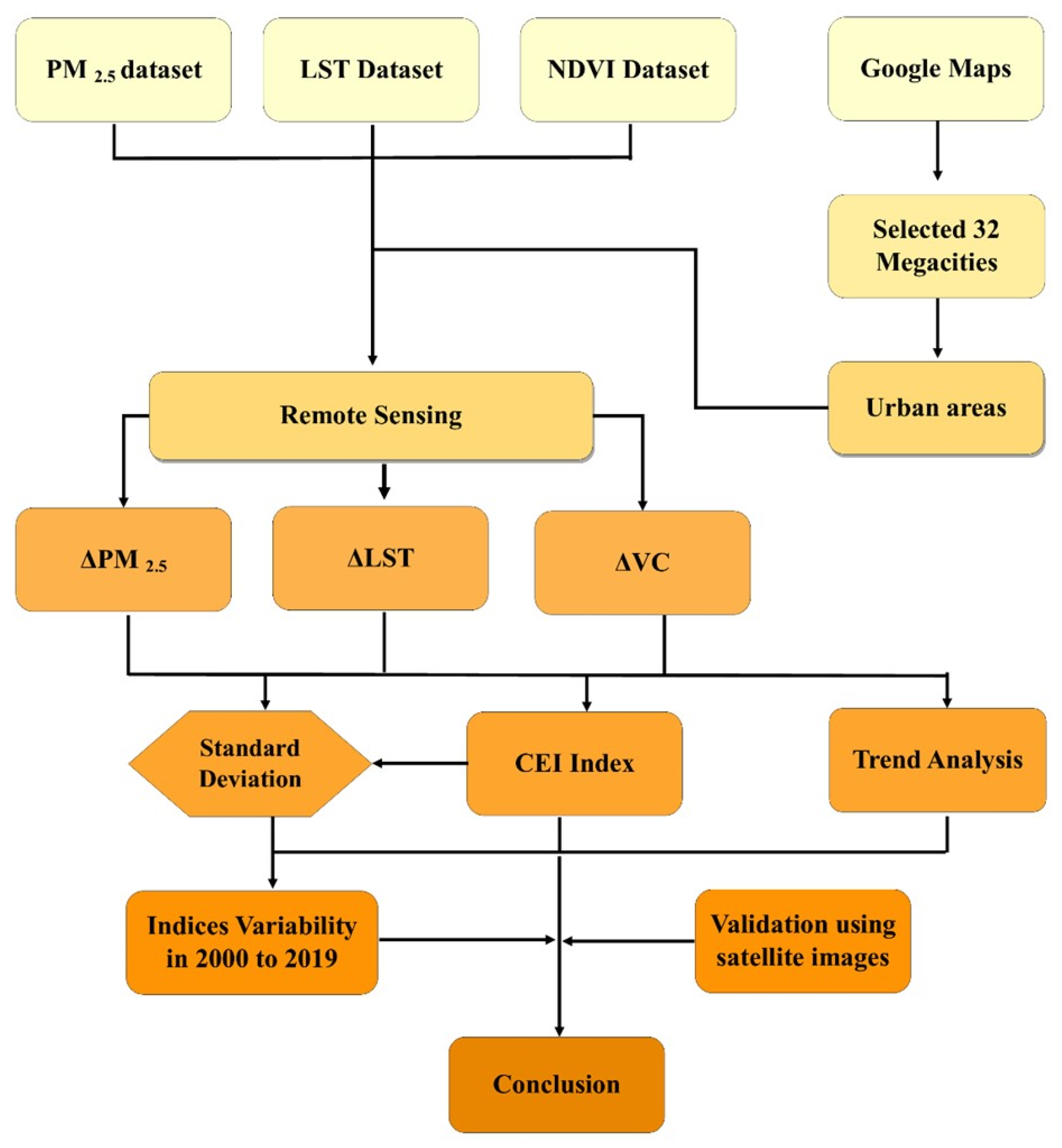
2. Materials and Methods
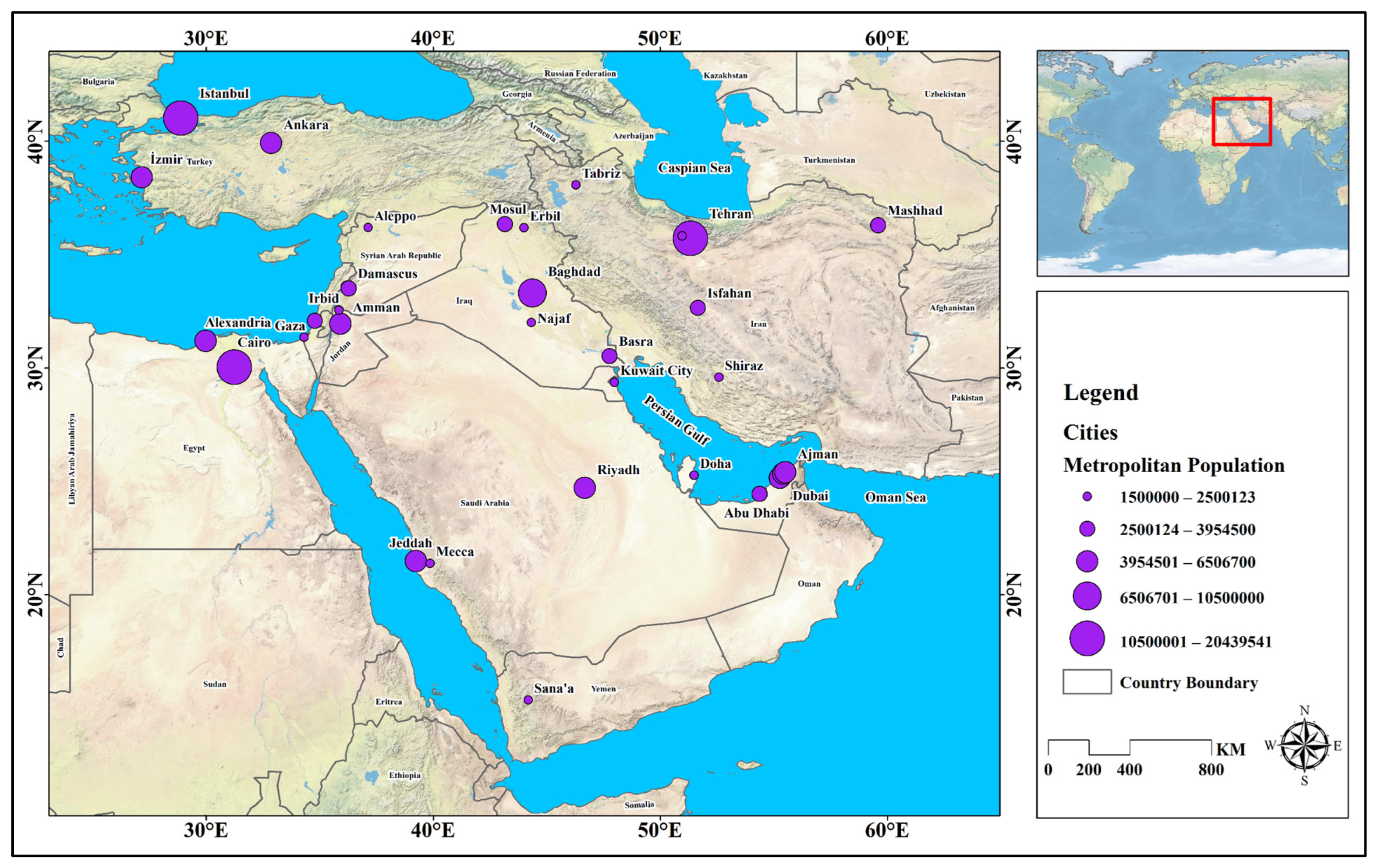
2.1. Case Study
2.2. Data Sets
2.3. Methodology
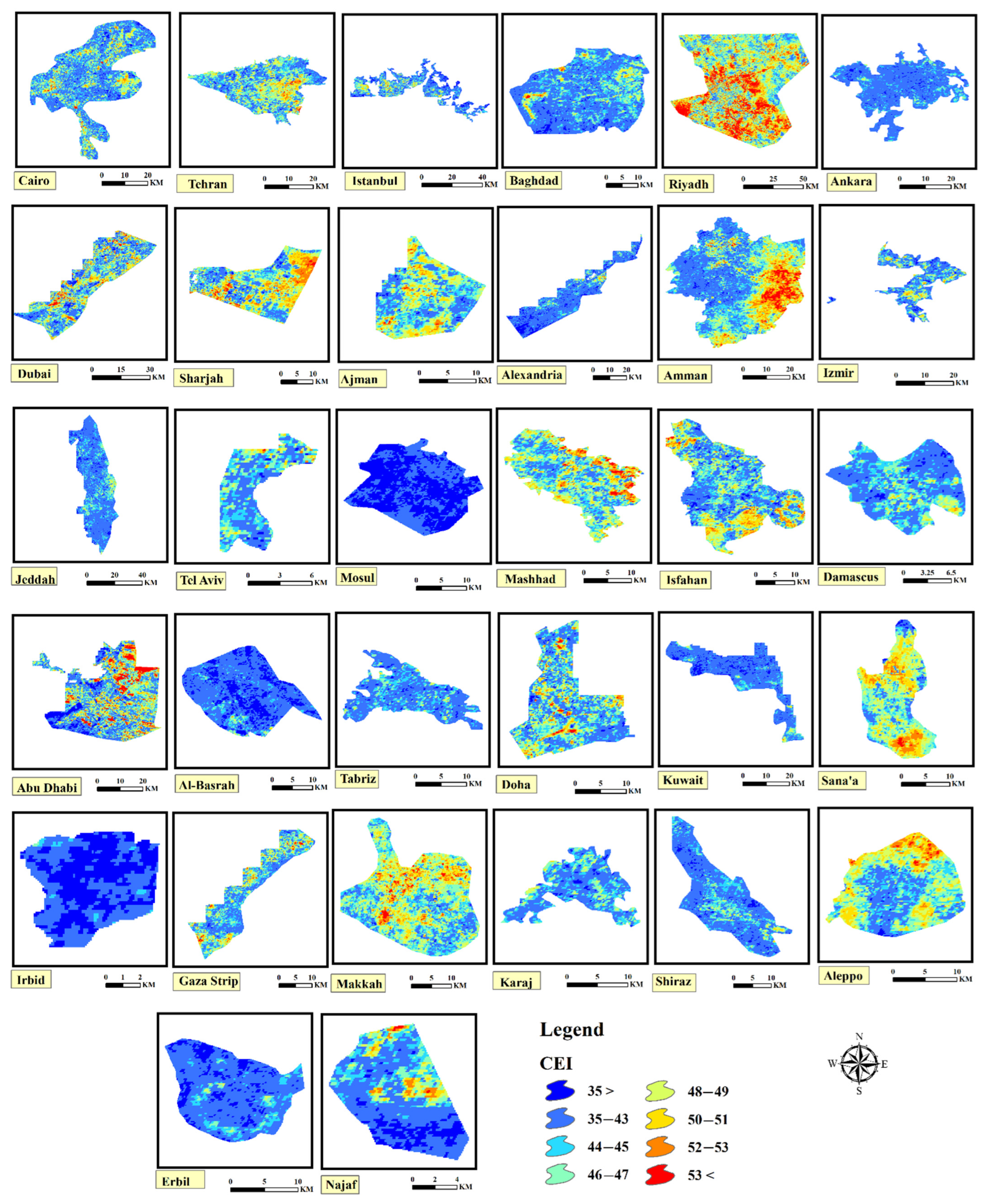
2.3.1. CEI Derivation
2.3.2. Trend Analysis
3. Results
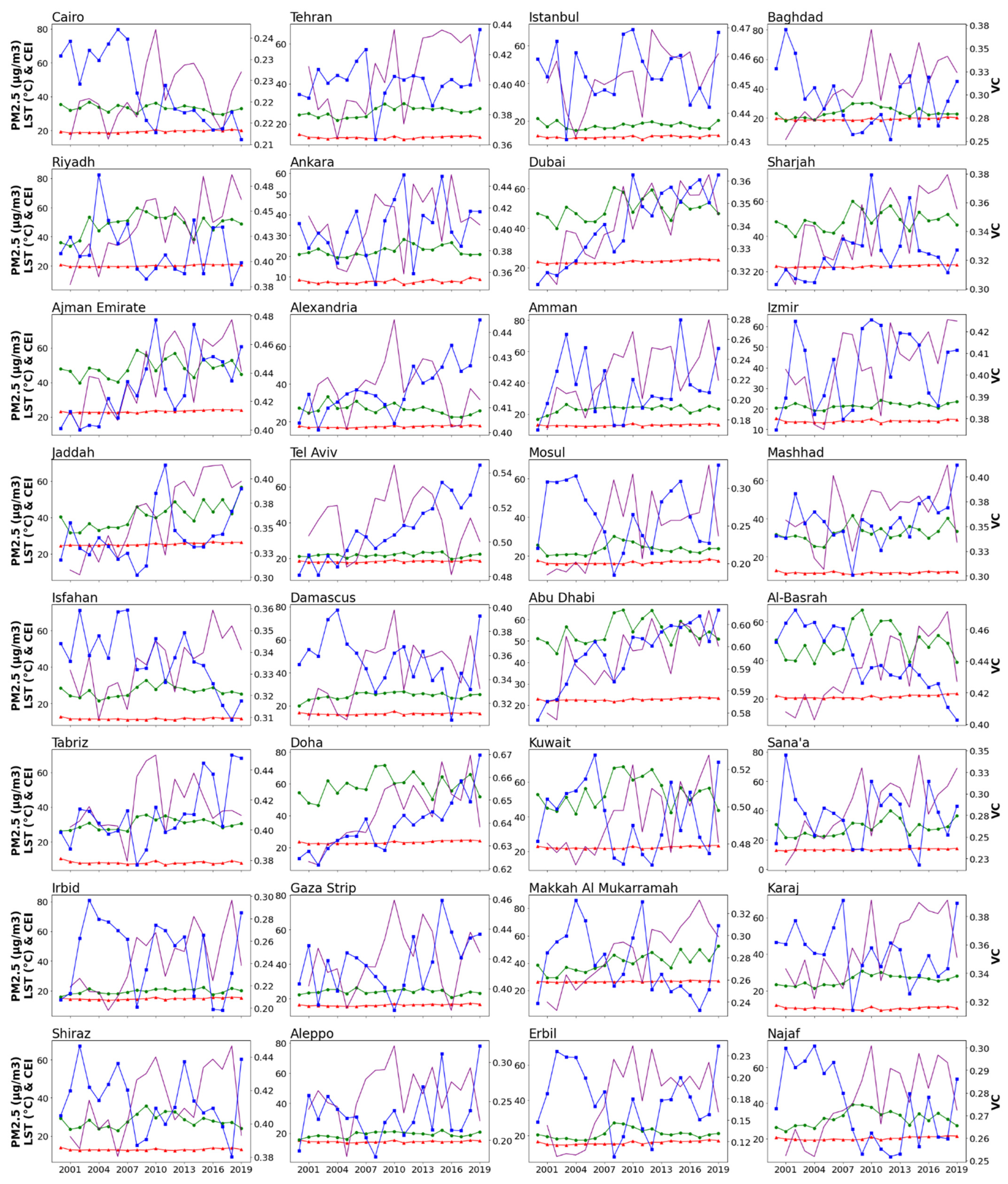
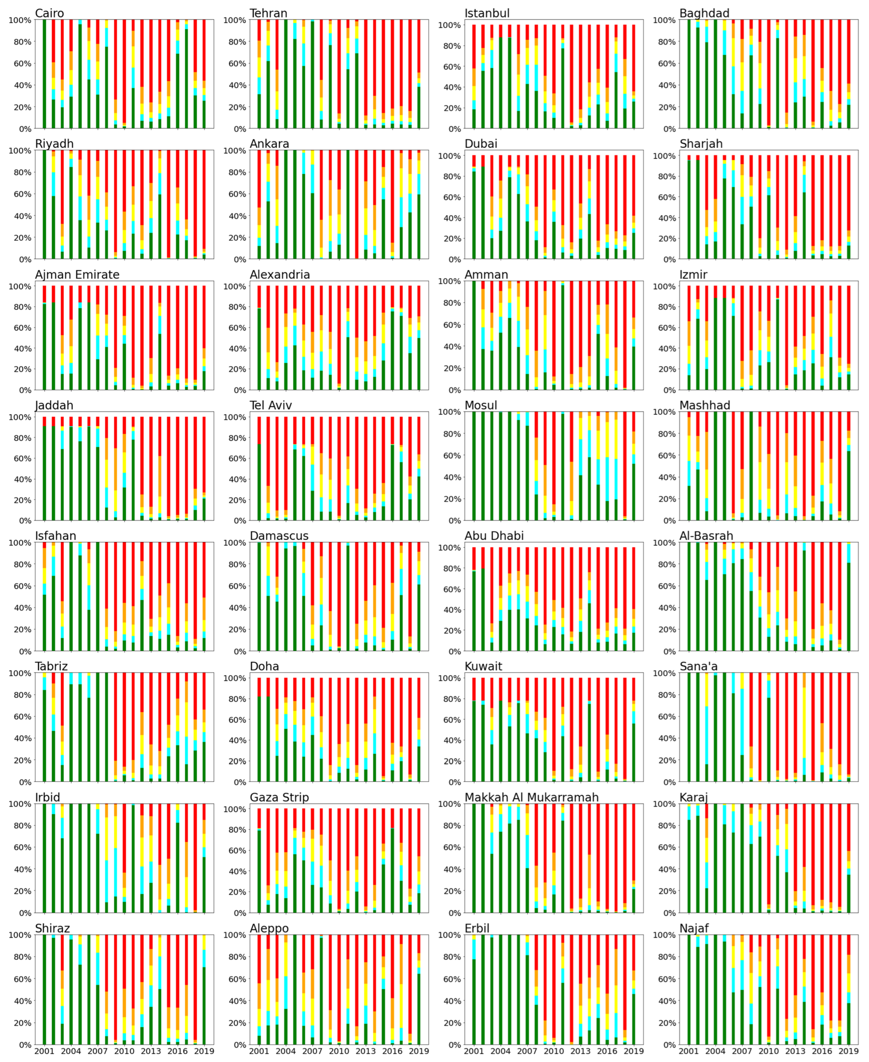
3.1. Inter-Annual Variation and Trends in PM2.5, LST, and VC
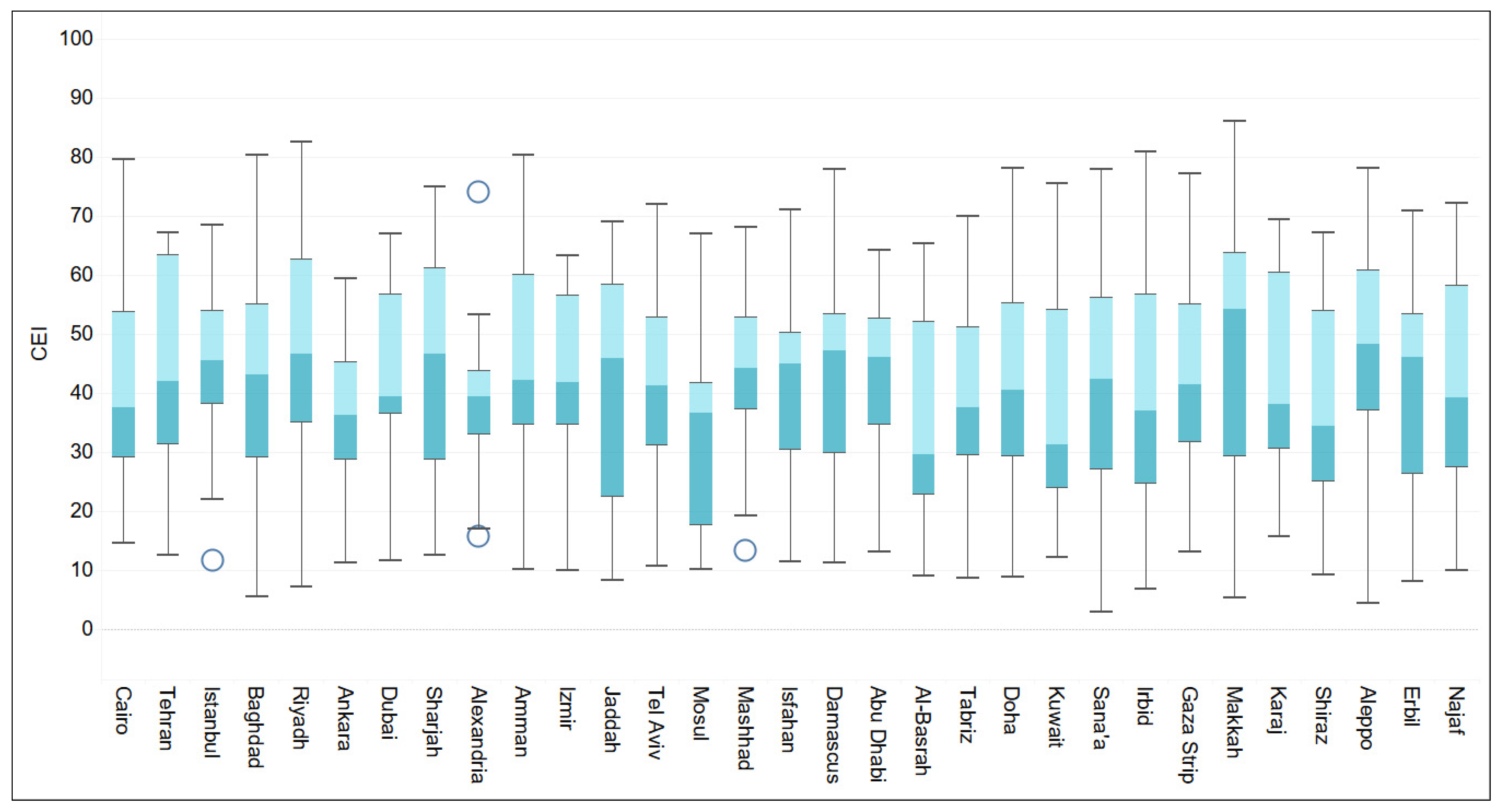
3.2. Inter-Annual Variation and Trends in CEI
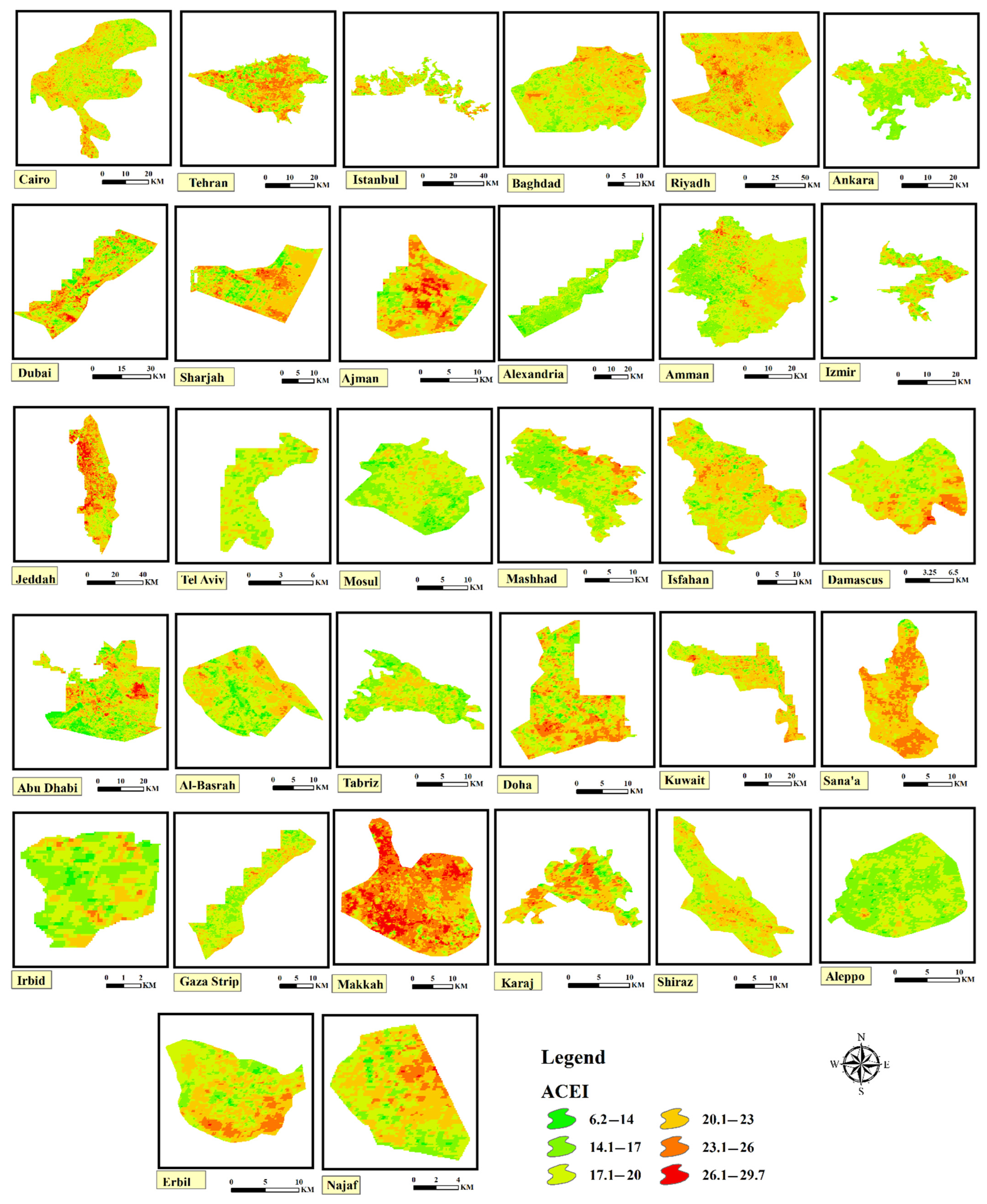
3.3. Regression Analysis between ACEI Abnormality and Normalized Indices
4. Discussion
5. Conclusions
Author Contributions
Funding
Data Availability Statement
Acknowledgments
Conflicts of Interest
References
- Barresi, A.; Pultrone, G. European strategies for smarter cities. TeMA-J. Land Use Mobil. Environ. 2013, 6, 61–72. [Google Scholar]
- Gargiulo, C.; Zucaro, F. Smartness and urban resilience. A model of energy saving. TeMA-J. Land Use Mobil. Environ. 2015, 8, 81–102. [Google Scholar]
- Marans, R.W. Quality of urban life & environmental sustainability studies: Future linkage opportunities. Habitat Int. 2015, 45, 47–52. [Google Scholar]
- Cilliers, S.; Toit, M.D.; Cilliers, J.; Drewes, E.; Retief, F. Sustainable urban landscapes: South African perspectives on transdisciplinary possibilities. Landsc. Urban Plan. 2014, 125, 260–270. [Google Scholar] [CrossRef]
- Zarabi, A.; Saberi, H.; Mohammadi, J.; Varesi, H.R. Spatial Analysis of Smart Growth Indicators (The Case Study: Regions of Isfahan). Hum. Geogr. Res. 2011, 43, 1–18. [Google Scholar]
- Meshkini, A.; Moazzen, S.; Norouz, M. Measuring the Quality of Urban Environment in Small Cities in East Azerbaijan Province. Urban Ecol. Res. 2016, 6, 17–32. [Google Scholar]
- Ahmadi, F.; Nasiriani, K.; Abazari, P. Delphi technique, IJME-Iran. Med. Educ. 2008, 8, 175–185. [Google Scholar]
- Morais, P.; Camanho, A.S. Evaluation of performance of European cities with the aim to promote quality of life improvements. Omega 2011, 39, 398–409. [Google Scholar] [CrossRef] [Green Version]
- Ahmadian, S.; Morovati, M.; Robati, M.; Sadeghinia, M. Valuating urban environmental quality using factor analysis method (case study: Kermanshah metropolis). Environ. Sci. 2018, 16, 149–164. [Google Scholar]
- Wan, H.; Huo, F.; Niu, Y.; Zhang, W.; Zhang, Q. Dynamic monitoring and analysis of ecological environment change in Cangzhou City based on RSEI model considering PM2.5 concentration. Prog. Geophys. 2021, 3, 953–960. [Google Scholar]
- Rabiei-Dastjerdi, H.; Mohammadi, S.; Saber, M.; Amini, S.; McArdle, G. Spatiotemporal Analysis of NO2 Production Using TROPOMI Time-Series Images and Google Earth Engine in a Middle Eastern Country. Remote Sens. 2022, 14, 1725. [Google Scholar] [CrossRef]
- Rabiei-Dastjerdi, H.; Matthews, S.A. Who gets what, where, and how much? Composite index of spatial inequality for small areas in Tehran. Reg. Sci. Policy Pract. 2021, 13, 191–205. [Google Scholar] [CrossRef]
- Mohammadi, S.; Balouei, F.; Haji, K.; Khaledi Darvishan, A.; Karydas, C.G. Country-scale spatiotemporal monitoring of soil erosion in Iran using the G2 model. Int. J. Digit. Earth 2021, 14, 1019–1039. [Google Scholar] [CrossRef]
- Deng, C.; Wu, C. BCI: A biophysical composition index for remote sensing of urban environments. Remote Sens. Environ. 2012, 127, 247–259. [Google Scholar] [CrossRef]
- Yue, H.; Liu, Y.; Li, Y.; Lu, Y. Eco-environmental quality assessment in China’s 35 major cities based on remote sensing ecological index. IEEE Access 2019, 7, 51295–51311. [Google Scholar] [CrossRef]
- Shruti, S.; Singh, K.; Ohri, A. Evaluating the environmental sustainability of smart cities in India: The design and application of the Indian smart city environmental sustainability index. Sustainability 2020, 13, 327. [Google Scholar] [CrossRef]
- Rabiei-Dastjerdi, H.; Matthews, S.A.; Ardalan, A. Measuring spatial accessibility to urban facilities and services in Tehran. Spat. Demogr. 2018, 6, 17–34. [Google Scholar] [CrossRef]
- Musse, M.A.; Barona, D.A.; Rodriguez, L.M.S. Urban environmental quality assessment using remote sensing and census data. Int. Appl. Earth Obs. Geoinf. 2018, 71, 95–108. [Google Scholar] [CrossRef]
- He, C.; Gao, B.; Huang, Q.; Ma, Q.; Dou, Y. Environmental degradation in the urban areas of China: Evidence from multi-source remote sensing data. Remote Sens. Environ. 2017, 193, 65–75. [Google Scholar] [CrossRef]
- Lu, L.; Weng, Q.; Guo, H.; Feng, S.; Li, Q. Assessment of urban environmental change using multi-source remote sensing time series (2000–2016): A comparative analysis in selected megacities in Eurasia. Sci. Total Environ. 2019, 684, 567–577. [Google Scholar] [CrossRef]
- Xia, X.; Jiao, C.; Song, S.; Zhang, L.; Feng, X.; Huang, Q. Developing a method for assessing environmental sustainability based on the Google Earth Engine platform. Environ. Sci. Pollut. Res. 2022, 29, 57437–57452. [Google Scholar] [CrossRef] [PubMed]
- Zhang, T.; Yang, R.; Yang, Y.; Li, L.; Chen, L. Assessing the Urban Eco-Environmental Quality by the Remote-Sensing Ecological Index: Application to Tianjin, North China. ISPRS Int. J. Geo-Inf. 2021, 10, 475. [Google Scholar] [CrossRef]
- Ostovari, Y.; Moosavi, A.A.; Mozaffari, H.; Poppiel, R.R.; Tayebi, M.; Demattê, J.A. Soil erodibility and its influential factors in the Middle East. In Computers in Earth and Environmental Sciences; Elsevier: Amsterdam, The Netherlands, 2022; pp. 441–454. [Google Scholar]
- Van Donkelaar, A.; Martin, R.V.; Brauer, M.; Hsu, N.C.; Kahn, R.A.; Levy, R.C.; Lyapustin, A.; Sayer, A.M.; Winker, D.M. Global estimates of fine particulate matter using a combined geophysical-statistical method with information from satellites, models, and monitors. Environ. Sci. Technol. 2016, 50, 3762–3772. [Google Scholar] [CrossRef] [PubMed]
- Hammer, M.S.; van Donkelaar, A.; Li, C.; Lyapustin, A.; Sayer, A.M.; Hsu, N.C.; Levy, R.C.; Garay, M.J.; Kalashnikova, O.V.; Kahn, R.A.; et al. Global estimates and long-term trends of fine particulate matter concentrations (1998–2018). Environ. Sci. Technol. 2020, 54, 7879–7890. [Google Scholar] [CrossRef]
- Li, Y.; Liao, Q.; Zhao, X.; Tao, Y.; Bai, Y.; Peng, L. Premature mortality attributable to PM2. 5 pollutions in China during 2008–2016: Underlying causes and responses to emission reductions. Chemosphere 2021, 263, 127925. [Google Scholar] [CrossRef]
- Xiao, Q.; Geng, G.; Liang, F.; Wang, X.; Lv, Z.; Lei, Y.; Huang, X.; Zhang, Q.; Liu, Y.; He, K. Changes in spatial patterns of PM2.5 pollutions in China 2000–2018: Impact of clean air policies. Environ. Int. 2020, 141, 105776. [Google Scholar] [CrossRef]
- Fenech, S.; Doherty, R.M.; Heaviside, C.; Macintyre, H.L.; O’Connor, F.M.; Vardoulakis, S.; Neal, L.; Agnew, P. Meteorological drivers and mortality associated with O3 and PM2.5 air pollution episodes in the UK in 2006. Atmos. Environ. 2019, 213, 699–710. [Google Scholar] [CrossRef]
- Etchie, T.O.; Etchie, A.T.; Adewuyi, G.O.; Pillarisetti, A.; Sivanesan, S.; Krishnamurthi, K.; Arora, N.K. The gains in life expectancy by ambient PM2.5 pollution reductions in localities in Nigeria. Environ. Pollut. 2018, 236, 146–157. [Google Scholar] [CrossRef]
- Zhengming, W.; Simon, H.; Glynn, H. MOD11A1 MODIS/Terra Land Surface Temperature/Emissivity Daily L3 Global 1 km SIN Grid V006. NASA EOSDIS Land Processes DAAC, 2015. Available online: https://lpdaac.usgs.gov/products/mod11a1v006/ (accessed on 16 September 2022).
- Oke, T.R. The energetic basis of the urban heat island. Q. J. R. Meteorol. Soc. 1982, 108, 1–24. [Google Scholar] [CrossRef]
- Santamouris, M. Analyzing the heat island magnitude and characteristics in one hundred Asian and Australian cities and regions. Sci. Total Environ. 2015, 512, 582–598. [Google Scholar] [CrossRef]
- Sellers, P.J.; Tucker, C.J.; Collatz, G.J.; Los, S.O.; Justice, C.O.; Dazlich, D.A.; Randall, D.A. A revised land surface parameterization (SiB2) for atmospheric GCMs. Part II: The generation of global fields of terrestrial biophysical parameters from satellite data. J. Clim. 1996, 9, 706–737. [Google Scholar] [CrossRef]
- Lu, L.; Kuenzer, C.; Wang, C.; Guo, H.; Li, Q. Evaluation of three MODIS-derived vegetation index time series for dryland vegetation dynamics monitoring. Remote Sens. 2015, 7, 7597–7614. [Google Scholar] [CrossRef] [Green Version]
- Nazarenko, Y.; Pal, D.; Ariya, P.A. Air quality standards for the concentration of particulate matter 2.5, global descriptive analysis. Bull. World Health Organ. 2021, 99, 125. [Google Scholar] [CrossRef] [PubMed]
- Li, J.; Wang, N.; Wang, J.; Li, H. Spatiotemporal evolution of the remotely sensed global continental PM2.5 concentrations from 2000–2014 based on Bayesian statistics. Environ. Pollut. 2018, 238, 471–481. [Google Scholar] [CrossRef] [PubMed] [Green Version]
- Mardani, G.; Alikhani Faradonbeh, M.; Fatahian Kelishadrokhi, Z.; Raeisi Shahraki, H. Modeling trend changes of mean annual exposure to PM2.5 particles in the Middle East countries via growth mixture models. Arab. J. Geosci. 2021, 14, 1–6. [Google Scholar] [CrossRef]
- Bu, X.; Xie, Z.; Liu, J.; Wei, L.; Wang, X.; Chen, M.; Ren, H. Global PM2.5-attributable health burden from 1990 to 2017: Estimates from the Global Burden of disease study 2017. Environ. Res. 2021, 197, 111123. [Google Scholar] [CrossRef]
- Han, L.; Zhou, W.; Li, W.; Qian, Y. Urbanization strategy and environmental changes: An insight with relationship between population change and fine particulate pollution. Sci. Total Environ. 2018, 642, 789–799. [Google Scholar] [CrossRef]
- Amini, S.; Saber, M.; Rabiei-Dastjerdi, H.; Homayouni, S. Urban Land Use and Land Cover Change Analysis Using Random Forest Classification of Landsat Time Series. Remote Sens. 2022, 14, 2654. [Google Scholar] [CrossRef]
- Bozorgi, M.; Nejadkoorki, F.; Bihamta Toosi, N. Trend analysis development of urban heat island using thermal remote sensing. Earth Obs. Geomat. Eng. 2020, 4, 119–131. [Google Scholar]
- El Kenawy, A.M.; Hereher, M.; Robaa, S.M.; McCabe, M.F.; Lopez-Moreno, J.I.; Domínguez-Castro, F.; Gaber, I.M.; Al-Awadhi, T.; Al-Buloshi, A.; Al Nasiri, N.; et al. Nocturnal surface urban heat island over Greater Cairo: Spatial morphology, temporal trends and links to land-atmosphere influences. Remote Sens. 2020, 12, 3889. [Google Scholar] [CrossRef]
- Megahed, Y.; Cabral, P.; Silva, J.; Caetano, M. Land cover mapping analysis and urban growth modelling using remote sensing techniques in Greater Cairo Region—Egypt. ISPRS Int. J. Geo-Inf. 2015, 4, 1750–1769. [Google Scholar] [CrossRef] [Green Version]
- Karaburun, A.; Demirci, A. Suen, I.-S. Impacts of urban growth on forest cover in Istanbul (1987–2007). Environ. Monit. Assess. 2010, 166, 267–277. [Google Scholar] [CrossRef] [PubMed]
- Bowler, D.E.; Buyung-Ali, L.; Knight, T.M.; Pullin, A.S. Urban greening to cool towns and cities: A systematic review of the empirical evidence. Landsc. Urban Plan. 2010, 97, 147–155. [Google Scholar] [CrossRef]
- Gaffin, S.R.; Rosenzweig, C.; Kong, A.Y. Adapting to climate change through urban green infrastructure. Nat. Clim. Change 2012, 2, 704. [Google Scholar] [CrossRef]
- Riechers, M.; Barkmann, J.; Tscharntke, T. Perceptions of cultural ecosystem services from urban green. Ecosyst. Serv. 2016, 17, 33–39. [Google Scholar] [CrossRef]
- Shirani-Bidabadi, N.; Nasrabadi, T.; Faryadi, S.; Larijani, A.; Roodposhti, M.S. Evaluating the spatial distribution and the intensity of urban heat island using remote sensing, case study of Isfahan City in Iran. Sustain. Cities Soc. 2019, 45, 686–692. [Google Scholar] [CrossRef]
- El Kenawy, A.M.; Hereher, M.E.; Robaa, S.M. An assessment of the accuracy of MODIS land surface temperature over Egypt using ground-based measurements. Remote Sens. 2019, 11, 2369. [Google Scholar] [CrossRef] [Green Version]
- Hereher, M.E. Time series trends of land surface temperatures in Egypt: A signal for global warming. Environ. Earth Sci. 2016, 75, 1–11. [Google Scholar] [CrossRef]
- Elhacham, E.; Alpert, P. Temperature patterns along an arid coastline experiencing extreme and rapid urbanization, case study: Dubai. Sci. Total Environ. 2021, 784, 147168. [Google Scholar] [CrossRef]
- Aldogom, D.; Aburaed, N.; Al-Saad, M.; Al Mansoori, S.; Al Shamsi, M.R.; Al Maazmi, A.A. Multi temporal satellite images for growth detection and urban sprawl analysis; Dubai City, UAE. Remote Sens. Technol. Appl. Urban Environ. IV 2019, 11157, 71–81. [Google Scholar]
- Alqurashi, A.F.; Kumar, L. Land use and land cover change detection in the Saudi Arabian desert cities of Makkah and Al-Taif using satellite data. Adv. Remote Sens. 2014, 3, 106. [Google Scholar] [CrossRef]
- Yagoub, M.; Alkaabi, K. Variation in land use/land cover and aircraft sound levels around Abu Dhabi International Airport. Eur. J. Geogr. 2019, 10, 68–84. [Google Scholar]


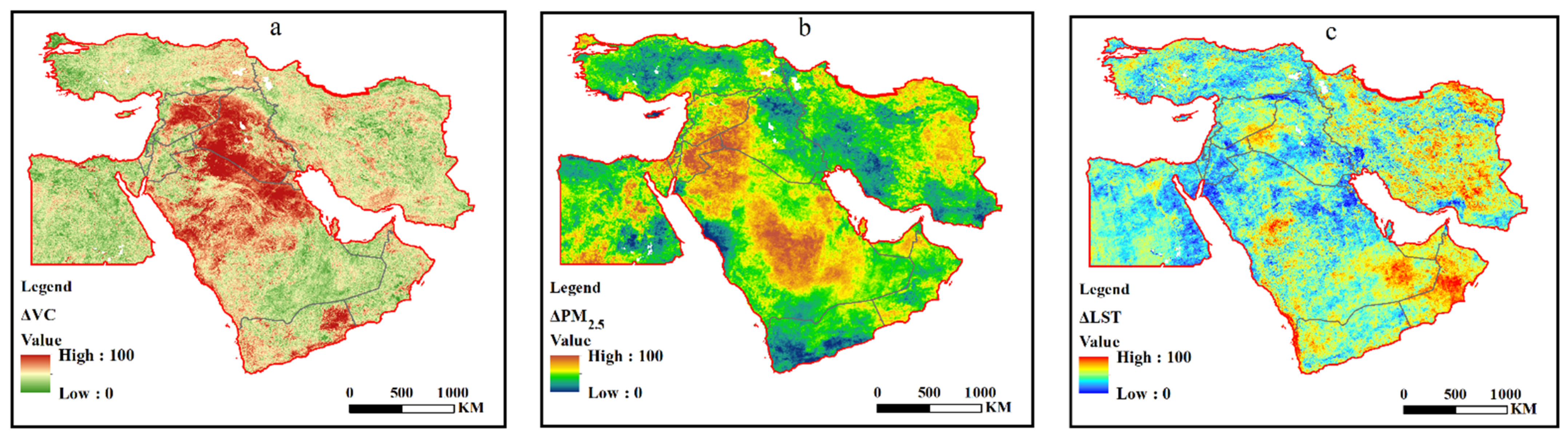
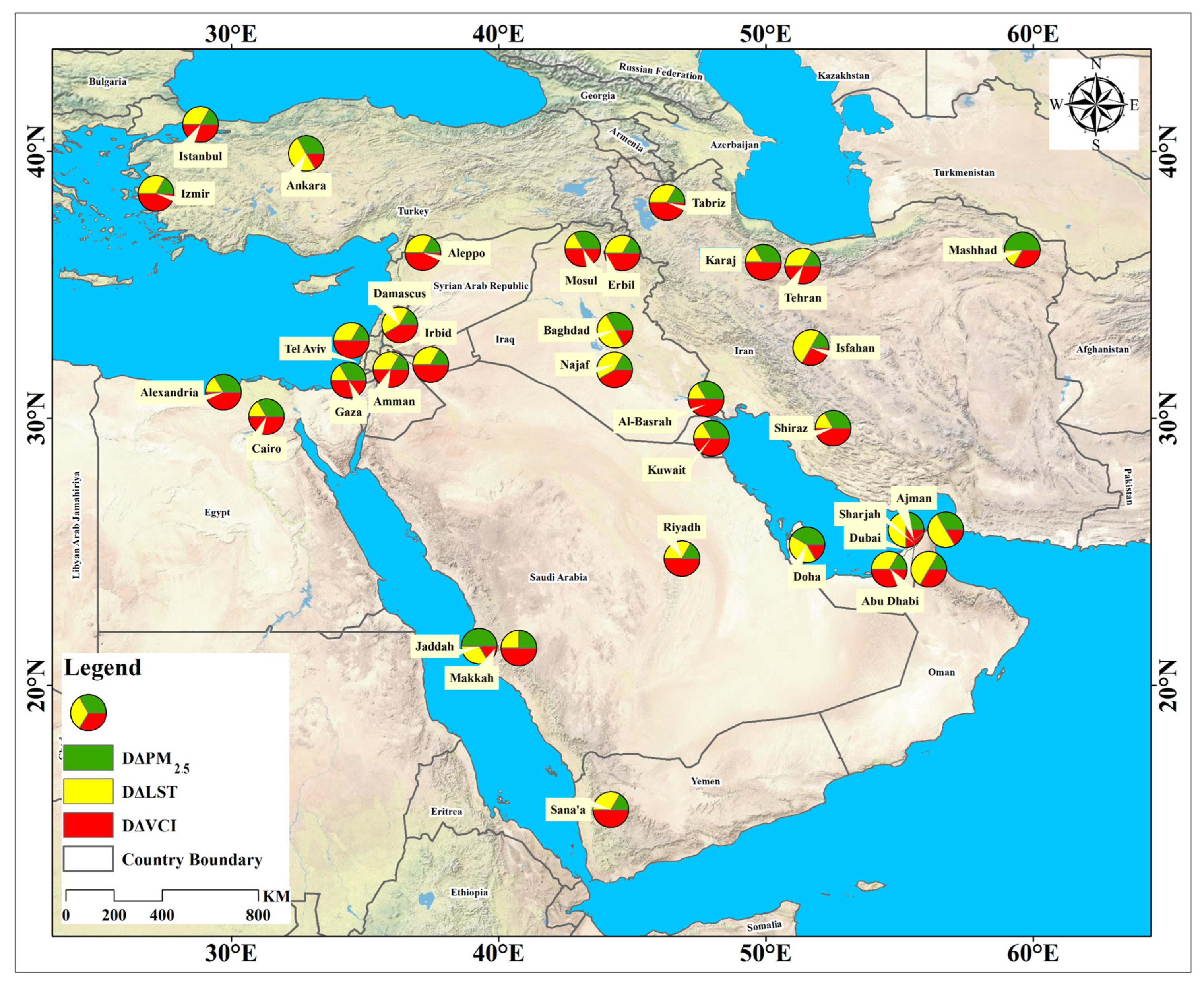
 VC,
VC,  PM2.5,
  LST, and
  CEI).
VC, PM2.5, LST, and CEI).
CEI).
VC, PM2.5, LST, and CEI).


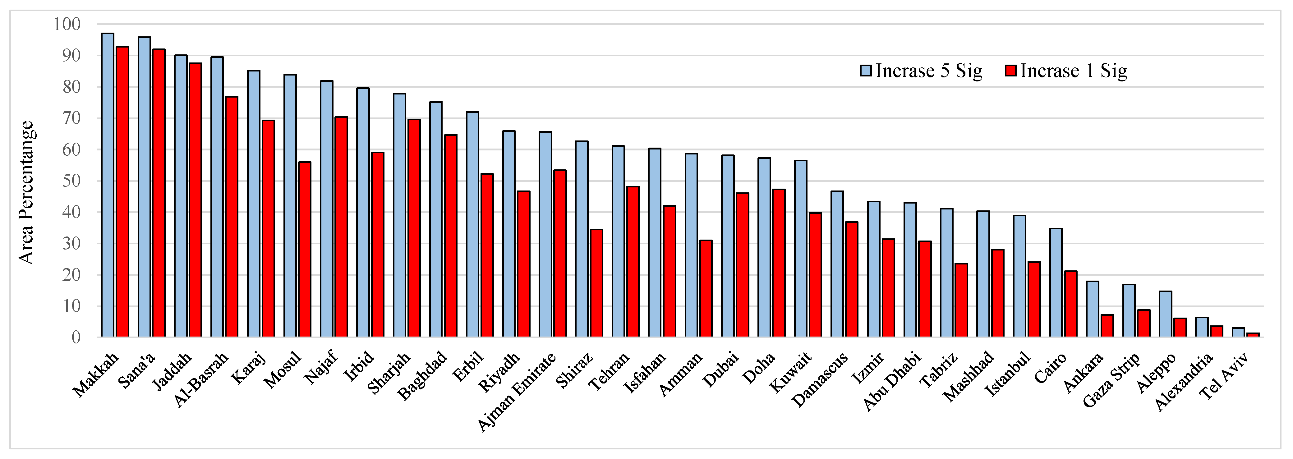
 degraded,
  moderately degraded,
  no change,
  moderately improved,
  improved).
degraded, moderately degraded, no change, moderately improved, improved).
improved).
degraded, moderately degraded, no change, moderately improved, improved).


| Rank | City | Country | Metropolitan (Population) | City (Population) |
|---|---|---|---|---|
| 1 | Cairo | Egypt | 20,439,541 | 9,500,000 |
| 2 | Tehran | Iran | 16,672,000 | 9,134,000 |
| 3 | Istanbul | Turkey | 15,519,267 | 15,241,177 |
| 4 | Baghdad | Iraq | 10,500,000 | 8,126,755 |
| 5 | Riyadh | Saudi Arabia | 6,506,700 | 6,506,700 |
| 6 | Ankara | Turkey | 5,663,322 | 5,067,565 |
| 7 | Dubai | United Arab Emirates | 5,640,000 | 3,287,007 |
| 8 | Sharjah | United Arab Emirates | 5,640,000 | 1,405,000 |
| 9 | Ajman | United Arab Emirates | 5,640,000 | 490,035 |
| 10 | Alexandria | Egypt | 4,984,387 | 4,984,387 |
| 11 | Amman | Jordan | 4,642,000 | 4,061,150 |
| 12 | İzmir | Turkey | 4,394,694 | 5,067,565 |
| 13 | Jeddah | Saudi Arabia | 4,276,000 | 4,276,000 |
| 14 | Tel Aviv | Israel | 3,954,500 | 438,818 |
| 15 | Mosul | Iraq | 3,750,000 | 1,683,000 |
| 16 | Mashhad | Iran | 3,600,650 | 3,372,090 |
| 17 | Isfahan | Iran | 2,989,070 | 2,000,000 |
| 18 | Damascus | Syria | 2,900,000 | 2,078,000 |
| 19 | Abu Dhabi | United Arab Emirates | 2,784,490 | 2,784,490 |
| 20 | Basra | Iraq | 2,750,000 | 2,750,000 |
| 21 | Tabriz | Iran | 2,500,123 | 2,000,000 |
| 22 | Doha | Qatar | 2,382,000 | 1,850,000 |
| 23 | Kuwait | Kuwait | 2,380,000 | 2,380,000 |
| 24 | Sana’a | Yemen | 2,167,000 | 1,937,451 |
| 25 | Irbid | Jordan | 2,050,300 | 582,276 |
| 26 | Gaza | Palestine | 2,047,969 | 590,481 |
| 27 | Mecca | Saudi Arabia | 2,042,000 | 2,042,000 |
| 28 | Karaj | Iran | 1,967,000 | 1,967,000 |
| 29 | Shiraz | Iran | 1,869,001 | 1,869,001 |
| 30 | Aleppo | Syria | 1,800,000 | 1,800,000 |
| 31 | Erbil | Iraq | 1,750,564 | 1,750,564 |
| 32 | Najaf | Iraq | 1,500,000 | 1,389,500 |
| Indicator | Data Generation | Country | Temporal Scale | Provider |
|---|---|---|---|---|
| PM2.5 | MODIS + MISR + SeaWiFS + GEOS-Chem | 1000 m | 2000–2019 | SEDAC |
| LST | Terra/MODIS/Night/Daily | 1000 m | 2000–2019 | NASA |
| NDVI | Terra/MODIS/NDVI/16 day | 250 m | 2000–2019 | NASA |
| City Boundaries | Google Maps | - | - | - |
| Type | Improved | Moderately Improved | No Change | Moderately Degraded | Degraded |
|---|---|---|---|---|---|
| Classification | <µ − 1.5δ | µ − 1.5δ to µ − 0.5δ | µ − 0.5δ to µ + 0.5δ | µ + 0.5δ to µ + 1.5δ | >µ + 1.5δ |
| CEI | 36.30 | 36.30 to 41.56 | 41.56 to 46.83 | 46.83 to 52.1 | 52.1< |
| City Name | LST | PM2.5 | VC | CEI | City Name | LST | PM2.5 | VC | CEI |
|---|---|---|---|---|---|---|---|---|---|
| Cairo | 0.102 ** | −0.139 * | −0.001 ** | 1.165 | Isfahan | 0.012 | 0.103 | −0.002 ** | 1.864 ** |
| Tehran | 0.031 | 0.207 * | 0 | 1.999 * | Damascus | 0.03 * | 0.145 | −0.002 | 1.533 |
| Istanbul | 0.061 * | 0.044 | 0 | 1.249 * | Abu Dhabi | 0.081 ** | 0.212 | 0.001 ** | 1.843 ** |
| Baghdad | 0.08 * | 0.163 | −0.002 | 2.618 ** | Al−Basrah | 0.107 ** | 0.19 | −0.003 ** | 2.863 ** |
| Riyadh | 0.087 ** | 0.41 | −0.001 | 2.853 ** | Tabriz | −0.008 | 0.171 | 0.002 * | 0.391 |
| Ankara | 0.05 | 0.122 | 0.001 | 1.063 | Doha | 0.118 ** | 0.404 | 0.002 ** | 2.843 ** |
| Dubai | 0.123 ** | 0.293 | 0.003 ** | 2.248 ** | Kuwait | 0.068 | 0.229 | 0 | 2.618 ** |
| Sharjah | 0.088 ** | 0.23 | 0.001 | 2.437 ** | Sana’a | 0.069 ** | 0.445 ** | 0 | 2.852 ** |
| Ajman | 0.103 ** | 0.219 | 0.003 ** | 2.396 ** | Irbid | 0.068 ** | 0.199 * | −0.001 | 2.689 ** |
| Alexandria | 0.062 ** | −0.174 * | 0.001 ** | 0.034 | Gaza | 0.070 ** | 0.003 | 0.001 | 0.849 |
| Amman | 0.065 ** | 0.162 | 0.001 | 1.960 * | Makkah | 0.057 ** | 0.929 ** | −0.002 | 3.833 ** |
| Izmir | 0.043 | 0.124 * | 0.001 | 1.676 ** | Karaj | 0.016 | 0.265 * | −0.001 | 2.335 ** |
| Jeddah | 0.101 ** | 0.919 ** | 0.002 * | 3.231 ** | Shiraz | 0.019 | 0.08 | −0.001 | 1.925 * |
| Tel Aviv | 0.049 * | 0.046 | 0.003 ** | 0.37 | Aleppo | 0.021 | 0.135 | 0.001 | 0.673 |
| Mosul | 0.08 * | 0.132 | −0.001 | 2.012 ** | Erbil | 0.141 ** | 0.072 | −0.001 | 2.388 * |
| Mashhad | 0.036 | 0.253 | 0.002 | 1.013 | Najaf | 0.112 ** | 0.241 | −0.002 * | 2.780 ** |
Publisher’s Note: MDPI stays neutral with regard to jurisdictional claims in published maps and institutional affiliations. |
© 2022 by the authors. Licensee MDPI, Basel, Switzerland. This article is an open access article distributed under the terms and conditions of the Creative Commons Attribution (CC BY) license (https://creativecommons.org/licenses/by/4.0/).
Share and Cite
Mohammadi, S.; Saber, M.; Amini, S.; Mostafavi, M.A.; McArdle, G.; Rabiei-Dastjerdi, H. Environmental Conditions in Middle Eastern Megacities: A Comparative Spatiotemporal Analysis Using Remote Sensing Time Series. Remote Sens. 2022, 14, 5834. https://doi.org/10.3390/rs14225834
Mohammadi S, Saber M, Amini S, Mostafavi MA, McArdle G, Rabiei-Dastjerdi H. Environmental Conditions in Middle Eastern Megacities: A Comparative Spatiotemporal Analysis Using Remote Sensing Time Series. Remote Sensing. 2022; 14(22):5834. https://doi.org/10.3390/rs14225834
Chicago/Turabian StyleMohammadi, Shahin, Mohsen Saber, Saeid Amini, Mir Abolfazl Mostafavi, Gavin McArdle, and Hamidreza Rabiei-Dastjerdi. 2022. "Environmental Conditions in Middle Eastern Megacities: A Comparative Spatiotemporal Analysis Using Remote Sensing Time Series" Remote Sensing 14, no. 22: 5834. https://doi.org/10.3390/rs14225834