Review

A Blueprint for the Estimation of Seagrass Carbon Stock Using Remote Sensing-Enabled Proxies

1
School of Geosciences, University of Sydney, Madsen Building, Eastern Avenue, Sydney, NSW 2006, Australia
2
Centre for CubeSats, UAVs and Their Applications (CUAVA), University of Sydney, Sydney, NSW 2006, Australia
3
ArborCarbon Pty Ltd., Murdoch University, Rota Trans 1, Murdoch, WA 6150, Australia
4
Centre for Terrestrial Ecosystem Science & Sustainability, Harry Butler Institute, Murdoch University, Murdoch, WA 6150, Australia
*
Author to whom correspondence should be addressed.
Remote Sens. 2022, 14(15), 3572; https://doi.org/10.3390/rs14153572
Submission received: 26 May 2022 / Revised: 18 July 2022 / Accepted: 22 July 2022 / Published: 25 July 2022
(This article belongs to the Special Issue Use of Remote Sensing in Valuation of Blue Carbon and Its Co-benefits)

Abstract

:
Seagrass ecosystems sequester carbon at disproportionately high rates compared to terrestrial ecosystems and represent a powerful potential contributor to climate change mitigation and adaptation projects. However, at a local scale, rich heterogeneity in seagrass ecosystems may lead to variability in carbon sequestration. Differences in carbon sequestration rates, both within and between seagrass meadows, are related to a wide range of interrelated biophysical and environmental variables that are difficult to measure holistically using traditional field surveys. Improved methods for producing robust, spatially explicit estimates of seagrass carbon storage across large areas would be highly valuable, but must capture complex biophysical heterogeneity and variability to be accurate and useful. Here, we review the current and emerging literature on biophysical processes which shape carbon storage in seagrass beds, alongside studies that map seagrass characteristics using satellite remote sensing data, to create a blueprint for the development of remote sensing-enabled proxies for seagrass carbon stock and sequestration. Applications of satellite remote sensing included measuring seagrass meadow extent, estimating above-ground biomass, mapping species composition, quantifying patchiness and patch connectivity, determining broader landscape environmental contexts, and characterising seagrass life cycles. All of these characteristics may contribute to variability in seagrass carbon storage. As such, remote sensing methods are uniquely placed to enable proxy-based estimates of seagrass carbon stock by capturing their biophysical characteristics, in addition to the spatiotemporal heterogeneity and variability of these characteristics. Though the outlined approach is complex, it is suitable for accurately and efficiently producing a full picture of seagrass carbon stock. This review has drawn links between the processes of seagrass carbon sequestration and the capabilities of remote sensing to detect and characterise these processes. These links will facilitate the development of remote sensing-enabled proxies and support spatially explicit estimates of carbon stock, ensuring climate change mitigation and adaptation projects involving seagrass are accounted for with increased accuracy and reliability.

1. Introduction

The potential role of blue carbon as a natural climate mitigation strategy has prompted increased research focus on methods for monitoring coastal ecosystems [1]. Although the ecological value of seagrass meadows is long established [2], recognition of their value as important sinks in the global carbon cycle [3] highlights the need for robust monitoring and reporting on greenhouse gas (GHG) offset projects [4]. Seagrasses contribute disproportionately to organic carbon (Corg) burial, sequestering 10% of oceanic buried Corg despite occupying less than 0.2% of ocean area [5]. Despite their relatively small global area compared to tropical, temperate and boreal forests, they sequester carbon at a comparable rate [6]. Seagrasses also influence water flows, cycle nutrients, form the base of food webs, and offer shelter for a range of marine species [7], positioning them as providers of multiple ecosystem services beyond carbon sequestration [8,9]. Development of methods to accurately map seagrass and produce robust estimates of seagrass carbon storage across large geographical areas is needed to improve global carbon monitoring schemes and support protection and restoration efforts crucial for maintaining ecosystem services.
The carbon sequestration capacity of seagrass is of critical interest in climate change mitigation and adaptation including emissions reporting, GHG abatement schemes and offset projects [1,3]. Protocols for accurate quantification of seagrass carbon stock in the field have been developed [10], and incorporated into some national GHG inventories [11]. However, high inter- and intra-habitat variability in seagrass carbon stock and burial rates [12,13,14,15] suggests that regional-scale reporting would be strengthened by measurements which accurately capture this variability.
Satellite remote sensing has been used for continuous broad-scale monitoring of seagrass biomass and condition [16,17]. Synoptic monitoring of coastal ecosystems by satellite remote sensing can provide vital spatial information about the ecological characteristics of seagrasses as they change over time, supporting coastal management and conservation [18,19,20]. To incorporate seagrass in quantitative climate change mitigation and adaptation strategies, robust methods are required to translate these satellite-derived ecological characteristics into metrics relevant to estimates of carbon stock and sequestration rates. This involves consideration of the ecological characteristics of seagrass meadows as they relate to carbon sequestration and the capabilities of current and future remote sensing platforms.
Although optical satellite remote sensing has been used to characterise the ecological characteristics of seagrass, direct measurement of seagrass carbon stock or sequestration rates using only remote sensing data is still not possible. Therefore, determining estimates of seagrass carbon stocks from remote sensing-based measurements requires an understanding of biophysical processes that underlie seagrass carbon sequestration, and the spatial, temporal and spectral scales relevant to those processes. Developing this understanding is important for identifying biophysical variables usable in carbon stock assessments which are measurable from remote observation platforms. Addressing this challenge requires developing and refining biophysical proxies for total carbon stock that can be derived from remote sensing data and understanding the limitations of current and next-generation remote sensing platforms in sensing these proxies. Here, we present a new perspective on the role of current and emerging remote sensing technologies for broad scale assessment of seagrass carbon stocks through the development of suitable proxy measures.
This review will establish a framework for developing methods for satellite remote sensing-enabled estimation of seagrass carbon stock. In Section 2, we provide background on the key challenges for carbon accounting in seagrass environments. In Section 3, we outline the biophysical processes operating within seagrass environments that drive carbon sequestration rates. In Section 4 and Section 5, we carry out a literature review in order to identify viable methods for satellite remote sensing of seagrass biophysical characteristics. Based on this review, we consider a set of remote sensing proxies for carbon storage in seagrass which account for spatial heterogeneity and change over time. Finally, in Section 6, we relate these remote sensing proxies to current seagrass carbon accounting requirements, creating a blueprint for applying Tier 3 spatially explicit methods to seagrass carbon stock mapping and monitoring.

2. Background

Activities within the Land-Use, Land-Use Change and Forestry (LULUCF) sector, such as afforestation and habitat restoration, can provide cost-effective mechanisms for offsetting emissions, which play a key role in current and planned global climate change mitigation policy. Previous mitigation efforts of the LULUCF sector were generally focused on terrestrial forests and grasslands and omitted seagrass and other coastal ecosystems from national GHG inventories [21]. The Intergovernmental Panel on Climate Change (IPCC) addressed this omission with the release of the Coastal Wetlands supplement to their guidelines on GHG inventories [22]. However, seagrass contributions to carbon emissions have remained underreported and were yet to be fully integrated into national inventories [11,23]. National-level plans for climate change mitigation and adaptation, such as the Nationally Determined Contributions (NDCs) of parties to the Paris Agreement, continue to largely omit seagrass reporting. Of the 185 NDCs submitted by countries as of 2020, 64 included coastal wetlands, while only ten provided explicit reference to seagrasses [11].
Accurate carbon accounting intersects with issues of seagrass conservation. Seagrass meadows are degrading globally, with a rate of loss possibly as high as 7% per year [24]. Degradation of seagrass ecosystems represents a two-fold climate risk: reducing the capacity of blue carbon ecosystems to sequester carbon and provide co-benefits [25], and increased emissions caused by stored Corg partially remineralising to become atmospheric CO2 [26]. Conversely, seagrass meadow restoration substantially increases carbon storage in the soil [3,27]. A recent study estimated the combined possible mitigation benefit from avoided seagrass degradation and seagrass restoration to be 341 TgCO2 equivalent y−1 [28], based on a conservative global extent estimate [29]. Given the disproportionate carbon storage and high rate of change, incorporating seagrass conservation and restoration into national emissions reporting, GHG abatement schemes, and offset projects is critical to global climate mitigation efforts.
Accurate inclusion of seagrass ecosystems in carbon accounting estimates is currently limited by existing methodologies. Seagrass reporting in GHG inventories under the IPCC guidelines often employs Tier 1 or Tier 2 methods which rely on global and regional estimates of carbon stock, respectively [30]. Tier 3 methods model carbon stocks using spatially explicit methods. Unlike terrestrial LULUCF inventory contributions, methods for Tier 3 reporting have not been established for seagrass ecosystems. Tier 3 approaches are intended to provide greater accuracy than Tier 1 or 2, and require a robust understanding of underlying processes, and identification of appropriate inputs for models of carbon stock over time [31]. The ability to accurately model carbon stocks in seagrass meadows is contingent upon capture of reliable, high resolution remote sensing data that can be used to represent biophysical characteristics of seagrass ecosystems relevant to carbon sequestration at ecologically appropriate spatiotemporal scales. Improving remote sensing methods for characterising seagrass ecosystems therefore forms a critical agenda for improving coastal carbon accounting mechanisms [32].
A key challenge for developing accurate Tier 3 representations of seagrass is the heterogeneous biophysical characteristics of these ecosystems. The contribution of seagrasses toward carbon sequestration and co-benefits can vary geographically, and are influenced by biophysical characteristics and environmental conditions in ways that are still poorly understood [33,34,35,36]. Spatial heterogeneity introduces uncertainty in quantifying ecosystem services in other contexts [37,38], and measurements of carbon stock across different seagrass environments frequently vary by a factor > 20 [12,39]. Spatially explicit Tier 3 models would need to capture spatio-temporal heterogeneity inherent in seagrass meadows to enable accurate emissions reporting.
Carbon stocks in seagrass, as in other environments, can be divided into pools, primarily above-ground biomass (AGB), below-ground biomass (BGB), and soil carbon. In seagrass ecosystems, the soil pool comprises as much as 98% of the total ecosystem carbon stock [40]. Studies have shown that carbon storage potential can be extremely high even in areas with low AGB, primary productivity and areal extent [41,42]. This is a barrier for optical remote sensing as only the above-ground components of the plant and soil background contribute to the optical signal, making estimation of total carbon stock from the optical signal challenging. Despite these challenges, the absorption of electromagnetic radiation by water limits the use of other remote sensing methods, such as microwave remote sensing, to targets above the surface of water. As many seagrass meadows are fully submerged, satellite-borne optical remote sensing is most promising for producing synoptic seagrass biophysical data; however, microwave remote sensing may contribute complementary information for seagrasses present in the intertidal zone.
Accurate and broad-scale seagrass mapping for carbon reporting requires the repeatable, synoptic coverage provided by satellite remote sensing, rigorously calibrated and validated through field-based verification [43]. However, the heterogeneity within seagrass meadows and the challenges associated with optical remote sensing of seagrass carbon stock limits the use of direct measurement of total carbon from space, necessitating the use of measurable biophysical “proxies” that can capture seagrass ecosystem heterogeneity and contribute to GHG inventories and carbon stock mapping. Appropriate proxies must reliably characterise overall carbon stock and the associated spatial heterogeneity and be measurable with optical remote sensing by satellite. It is also critical that the limitations of remotely sensed proxies for mapping overall carbon stock in seagrass meadows are clearly understood and described to provide accurate estimates of seagrass carbon stock and account for bias.

3. Processes and Drivers of Carbon Sequestration in Seagrass Meadows

Understanding the biophysical processes which drive seagrass carbon sequestration is key to identifying suitable remote sensing proxies to ensure that approaches to development of total carbon stock estimation methods have ecological relevance. Mazarrasa et al. [44] identified three processes which contribute to carbon stock in the soil pool: biomass accumulation (especially below-ground), allochthonous Corg sedimentation, and efficient burial of Corg (Figure 1).

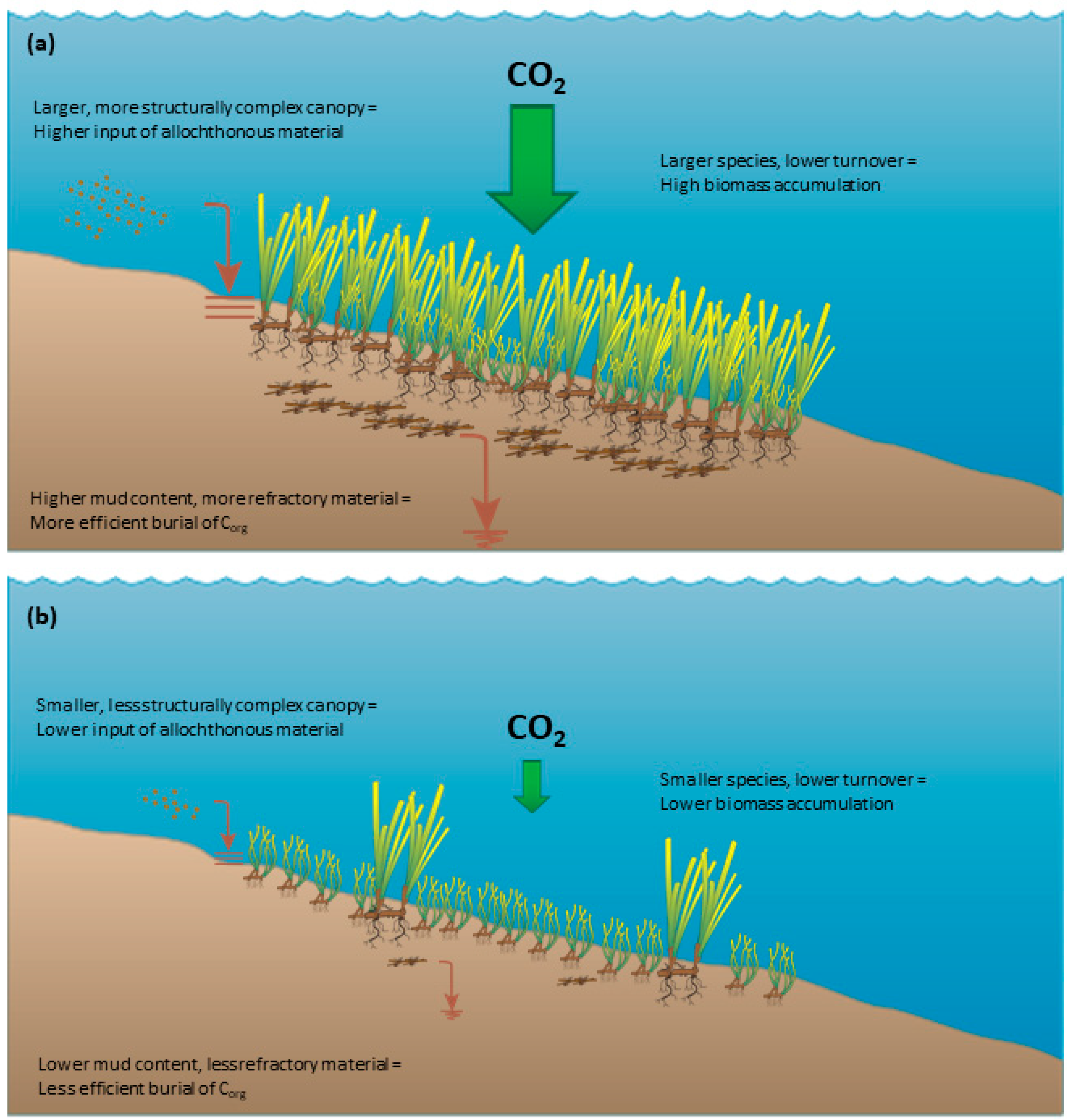
3.1. Biomass Accumulation and Autochthonous Contributions to Corg Stocks

Biomass accumulation is closely linked to the species composition of seagrass meadows, as seagrasses display large interspecific differences in biomass. For example, AGB can vary from 2.3 g m−2 (Halophila stipulacea) to 1005 g m−2 (Amphibolis antarctica) [45], due to significant differences in shoot and leaf morphology. BGB varies similarly between species, with larger species tending to show both higher biomass and higher BGB to AGB ratios [45]. Certain species, most notably Posidonia oceanica, produce particularly large mattes of root and rhizome material [46]. Intraspecies variations in biomass have also been identified, occurring across environmental gradients, including nutrient availability, light availability, salinity and temperature [47,48,49,50]. The higher BGB to AGB ratio of morphologically larger seagrasses is important for carbon sequestration as roots and rhizomes are composed of more refractory material than shoots, are less prone to export via herbivory or physical disturbance, and are already located within the anoxic soils which facilitate long term Corg storage [51,52,53,54,55]. Morphologically larger seagrasses trend towards higher carbon storage [12,56,57,58], and have higher relative contribution of autochthonous compared to allochthonous inputs into the carbon stock [59,60].
The life cycles of seagrasses also show considerable interspecies variations. Smaller, colonizing species may exhibit full life cycles on the scale of months, while larger persistent species can take many years [61]. This is an important factor influencing carbon sequestration, as the lower turnover rates of persistent species lead to high biomass accumulation [44]. However, seagrass life cycles can also vary intraspecifically depending on environmental conditions [62,63]. The variation is significant enough that the same species can form both enduring and transitory meadows under different conditions [61,64]. These changing environmental conditions can follow annual cycles, or be related to shorter or longer-term changes caused by fluctuations in dynamic environments or major disturbance events such as storms [61]. Though the relationship between persistence and carbon storage is established [44], there has been limited investigation of intraspecific variation in seagrass life cycle or meadow form and its relationship to carbon sequestration.

3.2. Input of Allochthonous Corg into the Ecosystem

Input of allochthonous Corg is controlled both by biophysical characteristics of seagrass meadows and environmental conditions. Seagrass canopies influence the local hydrodynamic environment, increasing sedimentation and decreasing resuspension [54,65,66,67]. Morphologically larger species and mixed species meadows form canopies with higher complexity, which more effectively encourage sedimentation as they reduce water velocity and baffle sediments [44,68]. Higher density meadows also have a larger impact on local flow rates and sedimentation [69,70]. Input of allochthonous Corg is therefore influenced by the same set of biotic factors as biomass accumulation [44]. However, unlike biomass accumulation, which is indirectly shaped by abiotic factors that determine seagrass growth patterns, the input of allochthonous Corg is more heavily influenced by abiotic factors, especially those relating to sediment. The capture of allochthonous Corg by seagrass meadows first requires a sediment source, therefore source sediment characteristics including density, grain size, and Corg content influence carbon stocks [34,71,72,73]. Geomorphic setting also influences input of allochthonous Corg into the seagrass ecosystem. Small species in high-energy coastal settings have less capacity to capture sediment, while low-energy estuarine settings are associated with higher amounts of sedimentary Corg accumulation [60,74]. Although relationships between canopy complexity and supply of allochthonous Corg appear to exist [75], this relationship is complicated by the abiotic factors which influence sedimentation rate and sediment Corg content.
The spatial arrangement of the seagrass landscape is an additional dimension that influences input of allochthonous Corg into seagrass carbon stocks. Continuous meadows capture sediment more effectively than meadows fragmented into patches [76,77]. Carbon stocks within a patch tend to increase with distance from the patch edge [78]. The arrangement of gaps in seagrass meadows relative to the direction of water flow may also impact sedimentation, as flow attenuation will differ with variations in gap shape and arrangement [79,80]. The broader coastal landscape is also important, as proximal ecosystems that are highly productive such as mangroves can contribute Corg to seagrass sediments [81,82]. Similarly, the presence of nearby barrier reefs can drive the input of allochthonous Corg by reducing local wave energy [83]. The input of allochthonous Corg is therefore driven by the complex interactions of biotic and abiotic characteristics acting across varying spatial scales.

3.3. Efficient Burial of Corg

The burial efficiency of Corg determines the amount of organic material that will remain in the soil in the long term after being introduced through the processes of biomass accumulation and allochthonous sedimentation. This is influenced by conditions which lead to relatively high levels of recalcitrance, therefore lower levels of degradation into atmospheric CO2, in organic material in the soil. An anoxic soil environment, high mud content, and a large proportion of more refractory material such as roots and rhizomes are conducive to higher burial efficiency [44]. Seagrasses increase mud concentration in the soil by capturing fine sediments, in turn encouraging anoxic conditions and seagrass tissue recalcitrance [84]. The proportion of refractory material is linked to its origin, as autochthonous material tends to be more refractory than allochthonous. The efficient burial of Corg is therefore in part driven by the same conditions which lead to high biomass accumulation (morphologically larger, persistent species) and high input of allochthonous Corg (high rates of sedimentation and Corg-rich sediments).

3.4. Summary: Processes and Drivers of Seagrass Carbon Stocks

The drivers of seagrass carbon sequestration are complex. Larger, more persistent species lead to higher carbon stocks, especially when meadows are dense and less fragmented. This applies to both autochthonous and allochthonous components of total carbon stock, though the latter is more influenced by geomorphic setting and source sediment properties. Estimation of carbon stocks therefore requires an understanding of the species composition and morphology, the spatial arrangement of seagrass meadows, patterns of spatiotemporal change, and the broader coastal landscape context in which the meadow is situated.
Although larger seagrass species have consistently higher Corg stocks, other drivers of carbon sequestration can act in highly variable ways depending upon context [60]. The complexity of the relationships between drivers and carbon stocks highlights the need to account for key biophysical characteristics, their variability and heterogeneity, as well as environmental setting in the mapping of seagrass carbon stocks.

4. Review Method

A literature review was carried out to generate a library of established remote sensing methods to ascertain what biophysical characteristics have been measured in the past, how they were measured, and any technical limitations on their measurement. Studies to include in this library were identified through a systematic literature search.
Many remote sensing studies characterise seagrass without explicit reference to carbon stock or sequestration. For this reason, the search terms did not include reference to carbon, instead focusing on the subject (seagrass) and the method (satellite remote sensing). The following search terms were entered into Web of Science and Scopus: (“Seagrass” OR “submerged aquatic vegetation”) AND (“remote sensing” OR “remotely sensed” OR “satellite” OR “earth observation” OR “Landsat” OR “WorldView” OR “PlanetScope” OR “QuickBird” OR “IKONOS” OR “Sentinel-2”). The search was limited to academic journal articles published in English and studies published on or before 30 April 2022.
After deduplication, 1119 records were identified. The abstracts of these studies were examined and irrelevant records excluded. The full texts of the remaining studies were reviewed to ensure they:
  • Contained a clearly described and repeatable method;
  • Used optical satellite remote sensing data to attempt to measure at least one biophysical characteristic of seagrass;
  • Did not exclusively use manual image interpretation techniques.
A total of 204 studies fulfilled these criteria and were used to create the database of seagrass remote sensing methods, including a record of different methodological techniques and contextual information such as study site location.

5. Identifying Remote Sensing Proxies for Seagrass Carbon Stock: Possibilities and Challenges

Levels of carbon stock within seagrass meadows are influenced by biomass accumulation, the input of allochthonous Corg, the efficient burial of Corg [44], and the biophysical and environmental drivers of those processes. In this section, we examine potential remote sensing proxies for improving the measurement of seagrass carbon stocks and evaluate direct monitoring of blue carbon potential from space. Although recent modelling has highlighted the complexity of the relationships between potential remote proxies and seagrass carbon stock [36,60,85], the identification of proxies that can be measured from space, and an assessment of the limitations of such an approach is an important first step in conceiving a holistic remote sensing-enabled methodology for spatially explicit mapping of seagrass carbon stock.

5.1. Meadow Characteristics and Dynamics as Proxy Indicators of Carbon Stock

5.1.1. Aboveground Biomass (AGB)

Direct estimates of AGB, as well as the related biophysical metrics of percent cover and Leaf Area Index (LAI), have been widely used in studies characterising seagrass using satellite remote sensing [86,87,88,89,90,91] Approaches applied include discrete mapping of percent cover classes (e.g., [88,92]) and regression-based estimates of AGB on a per-pixel basis (e.g., [91,93]). Although AGB contributes as little as 2% of total carbon stock in seagrass ecosystems [40], AGB is closely related to both BGB and soil carbon [75,94]. The importance of seagrass productivity and canopy complexity in carbon sequestration and the viability of remote sensing-based measurements of AGB and related characteristics highlight the potential of seagrass AGB as a remote sensing-based proxy for carbon stock.
The challenge in identifying the ideal approach for deriving estimates of seagrass AGB as a proxy for carbon stock is the selection of remote sensing methods that are both ecologically appropriate and capable of producing accurate results. From the three interrelated metrics described above, percent cover is more easily derived from remote sensing data compared to LAI and AGB, as it contributes more directly to the remote sensing signal. In comparison, LAI and AGB estimates are more limited, especially in dense seagrass meadows, due to saturation of the remote sensing signal [90,95,96]. As AGB incorporates information about the three-dimensional volume of plants it is the most abstracted of these three metrics from the remote sensing signal [97]. However, percent cover is less directly related to the accumulation of biomass and capture of allochthonous Corg than AGB and therefore a less direct proxy for overall carbon stock.
In the case of intertidal seagrass beds, the periodic absence of the water column provides additional remote sensing options for characterising seagrass AGB. Access to wavelengths of light which are highly attenuated by water makes common vegetation indices which rely upon near infrared reflectance, including the Normalised Difference Vegetation Index (NDVI), viable in intertidal environments [95,98]. Additionally, recent research has suggested that Synthetic Aperture Radar (SAR) data improve the accuracy of seagrass mapping, including AGB estimates, by providing information on surface structure which complements optical remote sensing data [99,100]. These approaches may also be applicable for seagrass beds which are emergent but not fully intertidal. These studies suggest that AGB estimates could be approached differently for intertidal and subtidal seagrass.
An important additional methodological consideration is whether to map AGB in discrete classes or as continuous values. As seagrass density can vary over light availability gradients [101,102], a continuous measurement would be more ecologically appropriate [103]. Remote sensing-derived estimates of AGB are likely to be an important proxy for total carbon stock, but their effective use requires a deeper understanding of methodological complexities to identify sensor properties data analysis techniques which can most accurately and reliably produce AGB estimates.

5.1.2. Meadow Species Composition

Species composition is an important consideration for the effective use of AGB-based carbon stock proxies. Significant differences in morphology and AGB to BGB ratio among seagrass species [45] suggest that classification of seagrasses by species could enhance the accuracy of satellite derived prediction of overall carbon stock. Although species composition is not a reliable direct proxy for carbon stock, it can complement AGB data and improve remote sensing-enabled carbon stock estimates.
Many species of seagrass are spectrally separable [87,104], and are therefore distinguishable using optical satellite remote sensing. However, spectral differences between seagrass species are often subtle [105], and epiphytic growth can interfere with spectral separability [106]. Beyond the spectral properties of individual leaves, the morphology of shoots can also impact their detection. Traganos and Reinartz [107,108] mapped two morphologically distinct species (Posidonia oceanica and Cymodocea nodosa) using Sentinel-2 [107] and RapidEye [108] satellite images. Sentinel-2 has a broader spectral range compared to RapidEye with data captured in a shorter wavelength coastal blue band. In both cases P. oceanica was classified more accurately than C. nodosa. When the narrower spectral range RapidEye images were used, the difference was considerable with an accuracy of 89–92% for P. oceanica and 50–61% for C. nodosa. These results suggest that although smaller species are more difficult to map accurately, a broader spectral range has the potential to improve detection. Methods that incorporate non-spectral data such as secondary textural characteristics or object-based approaches are effective in classifying species, even in relatively species-rich tropical areas [109,110,111]. These approaches may offer a useful alternative for overcoming spectral similarity and other species classification challenges such as turbidity which can impact on the spectral information.

5.1.3. Intra-Annual Variation in Seagrass Growth

Seagrass meadows exhibit intra-annual, seasonal variation in AGB [64,112] and at the extremes of habitat suitability, shoots can be completely absent for months of the year when water temperatures are outside the habitable range [113]. This is particularly relevant when using AGB as a proxy for carbon stock, because despite seasonal variability in seagrass growth, soil carbon and total carbon stock are more temporally stable [114]. Traditionally, biomass assessments were recommended during the peak growing season [115]. However, significant intraspecific differences in seagrass phenology can exist even with minor differences in environmental conditions. This is further complicated in mixed meadows, where interspecific differences in phenology lead to biomass peaks at different times [116]. Given the complex factors dictating peak biomass and the apparent variability in the ratio of AGB to overall carbon stock, assessments at intra-annual timescales should be considered to ensure robustness when measuring AGB as a proxy for overall carbon stock. In addition, importance of regular monitoring will increase in the future as the environmental conditions which dictate seagrass phenology shift under changing climate conditions [117].

5.2. Landscape Ecology Metrics and Spatial Characteristics as Proxies for Carbon Stock

5.2.1. Landscape Ecology Metrics Applied to Seagrass Meadows

The spatial structure and arrangement of seagrass meadows have been linked to rates of carbon burial, with studies showing that continuous seagrass meadows capture allochthonous Corg more effectively than fragmented meadows, leading to greater input of Corg into the sediments [76,77,78]. Landscape ecology metrics, which offer methods of quantifying the spatial arrangement of landscapes, may therefore provide a suitable remote sensing-based proxy for carbon stock across the seagrass landscape. Recognition of the system properties present in heterogeneous seascapes has prompted growing application of landscape ecology concepts and techniques to coastal and marine environments, including consideration of spatial context, configuration, connectivity, and the effects of scale [118].
Seagrass patches vary widely in size, often from 1–100 m in diameter [119]; however, the spatial scales at which spatial configuration and fragmentation significantly affect carbon sequestration are not well established. Although seascape metrics could provide an effective indicator of potential carbon stock, there is a need to determine the appropriate spatio-temporal scale for adequately capturing the biophysical processes influencing the relationship between the spatial configuration of seagrass meadows and carbon sequestration [120].
The spatial, spectral and temporal resolution of remote sensing data products will determine the seascape metrics that can realistically be measured [121]. Seascape metrics such as patch shape, area and edge length have been measured using aerial platforms [122,123,124] and patch complexity, connectivity and diversity have been quantified using high spatial resolution platforms, including GeoEye-1, IKONOS and SPOT 7 [125,126,127]. Studies have demonstrated the importance of ultra-high spatial resolution imagery for mapping patch level fragmentation [128,129], which may otherwise be masked in measures of overall seagrass density based on coarser spatial resolution imagery (Figure 2). Although there has been limited research linking landscape metrics and carbon stock using remote sensing data, modelling has shown that metrics related to heterogeneity and patch fragmentation are strong predictors of overall carbon stocks [36,72].

5.2.2. Landscape Context

Local landscape context influences the quantity and carbon content of sediment deposits [14,72]. In estuarine environments, seagrass meadows further inland and in areas less exposed to wave energy have higher sediment accretion rates, with studies showing carbon stocks decreasing along an oceanward gradient [14,85]. Additionally, proximity to ecosystems with high productivity and outflow of organic material, such as mangroves, is associated with increased carbon storage in seagrass meadows [36,81].
Broad characterisations of geomorphic setting have been found to be insufficient for predicting seagrass total carbon stocks, suggesting that the influence of landscape context varies locally depending on factors such as sediment deposition rates and surrounding geology [60,130]. This is relevant for remote sensing-based estimates of carbon stock as it suggests that measuring seagrass characteristics alone, without landscape context, risks missing key variables. Further, Asplund et al. [36] found that the predictive power of patch fragmentation metrics for estimating sedimentary Corg stock varied considerably between seagrass species. This work suggests that the effective use of landscape ecology-based proxies for seagrass carbon stock requires site specific understanding, including local landscape context and nearshore sedimentary environment.

5.3. Seagrass Life History and Phenological Time Series Analysis

Carbon storage potential is also influenced by the temporal dynamics of seagrass meadows, a characteristic that can be detected using remote sensing-based change detection analysis. Enduring seagrass meadows have higher carbon stores than transitory meadows [44,131], highlighting the importance of seasonal and multi-decadal monitoring of vegetation cover. Change detection can support carbon stock assessments in two ways. First, through classification of life history (e.g., persistent/opportunistic/colonising, enduring/transitory; [61]) which would enable differentiation between areas which show significant intraspecies differences in life cycle (not measurable using single date or annual image capture, see Figure 3). Second, using temporal analysis to derive phenological metrics can assist in differentiating species where spectral separability is poor, an approach successfully applied in terrestrial contexts [132]. Measures of intra-annual change and phenology have the potential to contribute directly as carbon storage proxies, or indirectly by supporting more accurate species classification.
Multi-temporal remote sensing analysis of seagrass introduces challenges. Differences in water column properties (e.g., tidal level, turbidity) between image dates or poor georegistration of mutitemporal images can introduce errors when they are confused for changes in seagrass extent or biophysical properties [133,134].
Despite the dynamic nature of seagrass meadows, there has been limited research on the use of remote sensing for characterising intra-annual variability, with most time series studies focused on longer-term change [108,135,136,137]. A relatively small number of studies have examined shorter term variation in seagrass using satellite remote sensing, often showing complex intra-annual dynamics [133,138,139]. Given the potential significance of seagrass life cycle for carbon storage, further research is needed on the application of remote sensing for continuous capture of phenological patterns across seagrass meadows.

6. Enabling Carbon Stock Estimates from Space

Remote sensing-based proxies of seagrass carbon stocks should be informed by an understanding of the underlying biophysical processes and drivers of carbon sequestration. Satellite remote sensing is well placed to:
  • Estimate AGB and its heterogeneity across space;
  • Classify seagrass ecosystems by species composition or dominant species;
  • Characterise the spatial configuration and landscape context of seagrass ecosystems, and quantify these characteristics using landscape ecology metrics;
  • Capture intra-annual variability of seagrass species composition and AGB to monitor seagrass life cycles and temporal change (Figure 4).
However, the processes underlying seagrass carbon sequestration are complex, often non-linear in nature and abstracted from remote sensing signals. For example, while measurement of seagrass AGB can be detected via remote sensing, critical carbon accounting variables such as sediment properties, including grain size, sedimentation rate and Corg content, cannot be directly measured from space. In many coastal settings, these sediment properties are the primary driver of carbon burial [14], while in other environments seagrass properties, such as species composition, play an important role [36]. Accurate estimates must be verified, not only through in situ field validation of satellite data, but through incorporating knowledge of seascape context, sediment dynamics and the relative contributions of different biophysical processes. Characterising the relative contributions of allochthonous and autochthonous Corg to the seagrass carbon pool, the variation in these processes over space and time, and the sediment properties determining the efficiency of Corg burial is critical for deriving effective spatially explicit estimates of carbon stock to support carbon accounting (Figure 4).

7. Conclusions

The globally significant contribution of seagrass ecosystems to carbon sequestration highlights the importance of rigorous methods to quantify carbon stock and stock change for incorporation into emissions reporting, GHG abatement schemes and offset projects. The processes involved in seagrass carbon sequestration are complex and require accurate characterisation of key biophysical characteristics of the seagrass.
Future work to develop spatially explicit models of seagrass carbon stock should focus on determining reliable proxies of carbon stock which can be measured in a synoptic manner. Seagrass carbon stocks have been estimated using predictive modelling [36,60,72], and the inclusion of ecologically relevant remote sensing-based data can ensure that these models accurately capture the complexity and heterogeneity of seagrass ecosystems. This will support the effective use of remote sensing data by helping to identify the roles of local environmental processes in shaping carbon sequestration. Additionally, seagrass carbon stock estimation may be improved through optimising remote sensing data collection (e.g., sensor spatial, temporal and spectral properties) and data analysis (e.g., accuracy and thematic resolution of outputs). Addressing these priorities will improve spatially explicit carbon stock estimations in critical seagrass ecosystems.

Author Contributions

Conceptualization, J.S., E.B., and K.P.D.; investigation, J.S.; resources, E.B., P.B. and K.P.D.; writing—original draft preparation, J.S.; writing—review and editing, J.S., E.B., P.B. and K.P.D.; visualization, J.S., E.B. and P.B.; supervision, E.B., P.B. and K.P.D.; project administration, E.B. and K.P.D.; funding acquisition, E.B. All authors have read and agreed to the published version of the manuscript.

Funding

This research was funded by the Australian Research Council, grant number IC170100023.

Data Availability Statement

Not applicable.

Acknowledgments

ArborCam images provided by ArborCarbon Pty Ltd., Murdoch, Australia.

Conflicts of Interest

The funders had no role in the design of the study; in the collection, analyses, or interpretation of data; in the writing of the manuscript; or in the decision to publish the results. P.B. is an employee of ArborCarbon.

References

  1. Macreadie, P.I.; Costa, M.D.; Atwood, T.B.; Friess, D.A.; Kelleway, J.J.; Kennedy, H.; Lovelock, C.E.; Serrano, O.; Duarte, C.M. Blue carbon as a natural climate solution. Nat. Rev. Earth Environ. 2021, 2, 826–839. [Google Scholar] [CrossRef]
  2. Thayer, G.W.; Wolfe, D.A.; Williams, R.B. The Impact of Man on Seagrass Systems: Seagrasses must be considered in terms of their interaction with the other sources of primary production that support the estuarine trophic structure before their significance can be fully appreciated. Am. Sci. 1975, 63, 288–296. [Google Scholar]
  3. Oreska, M.P.; McGlathery, K.J.; Aoki, L.R.; Berger, A.C.; Berg, P.; Mullins, L. The greenhouse gas offset potential from seagrass restoration. Sci. Rep. 2020, 10, 7325. [Google Scholar] [CrossRef] [PubMed]
  4. Campbell, A.D.; Fatoyinbo, T.; Charles, S.P.; Bourgeau-Chavez, L.L.; Goes, J.; Gomes, H.; Halabisky, M.; Holmquist, J.; Lohrenz, S.; Mitchell, C.; et al. A review of carbon monitoring in wet carbon systems using remote sensing. Environ. Res. Lett. 2022, 17, 025009. [Google Scholar] [CrossRef]
  5. Fourqurean, J.W.; Duarte, C.M.; Kennedy, H.; Marbà, N.; Holmer, M.; Mateo, M.A.; Apostolaki, E.T.; Kendrick, G.A.; Krause-Jensen, D.; McGlathery, K.J. Seagrass ecosystems as a globally significant carbon stock. Nat. Geosci. 2012, 5, 505–509. [Google Scholar] [CrossRef]
  6. McLeod, E.; Chmura, G.L.; Bouillon, S.; Salm, R.; Björk, M.; Duarte, C.M.; Lovelock, C.E.; Schlesinger, W.H.; Silliman, B.R. A blueprint for blue carbon: Toward an improved understanding of the role of vegetated coastal habitats in sequestering CO2. Front. Ecol. Environ. 2011, 9, 552–560. [Google Scholar] [CrossRef] [Green Version]
  7. Hemminga, M.A.; Duarte, C.M. Seagrass Ecology; Cambridge University Press: Cambridge, UK, 2000. [Google Scholar]
  8. Nordlund, L.; Koch, E.W.; Barbier, E.B.; Creed, J.C. Seagrass Ecosystem Services and Their Variability across Genera and Geographical Regions. PLoS ONE 2016, 11, e0163091. [Google Scholar] [CrossRef] [PubMed] [Green Version]
  9. Unsworth, R.K.; Nordlund, L.M.; Cullen-Unsworth, L.C. Seagrass meadows support global fisheries production. Conserv. Lett. 2019, 12, e12566. [Google Scholar] [CrossRef]
  10. Howard, J.; Hoyt, S.; Isensee, K.; Telszewski, M.; Pidgeon, E. Coastal Blue Carbon: Methods for Assessing Carbon Stocks and Emissions Factors in Mangroves, Tidal Salt Marshes, and Seagrasses; Conservation International: Arlington, VA, USA, 2014. [Google Scholar]
  11. United Nations Environment Programme. Out of the Blue: The Value of Seagrasses to the Environment and to People; UNEP: Nairobi, Kenya, 2020. [Google Scholar]
  12. Lavery, P.S.; Mateo, M.A.; Serrano, O.; Rozaimi, M. Variability in the carbon storage of seagrass habitats and its implications for global estimates of blue carbon ecosystem service. PLoS ONE 2013, 8, e73748. [Google Scholar] [CrossRef] [PubMed] [Green Version]
  13. Sanders, C.J.; Maher, D.T.; Smoak, J.M.; Eyre, B.D. Large variability in organic carbon and CaCO3 burial in seagrass meadows: A case study from three Australian estuaries. Mar. Ecol. Prog. Ser. 2019, 616, 211–218. [Google Scholar] [CrossRef]
  14. Ricart, A.M.; York, P.H.; Bryant, C.V.; Rasheed, M.A.; Ierodiaconou, D.; Macreadie, P.I. High variability of Blue Carbon storage in seagrass meadows at the estuary scale. Sci. Rep. 2020, 10, 5865. [Google Scholar] [CrossRef] [PubMed] [Green Version]
  15. Kim, S.H.; Suonan, Z.; Qin, L.-Z.; Kim, H.; Park, J.-I.; Kim, Y.K.; Lee, S.; Kim, S.-G.; Kang, C.-K.; Lee, K.-S. Variability in blue carbon storage related to biogeochemical factors in seagrass meadows off the coast of the Korean peninsula. Sci. Total Environ. 2022, 813, 152680. [Google Scholar] [CrossRef]
  16. Bramante, J.F.; Ali, S.M.; Ziegler, A.D.; Sin, T.M. Decadal biomass and area changes in a multi-species meadow in Singapore: Application of multi-resolution satellite imagery. Bot. Mar. 2018, 61, 289–304. [Google Scholar] [CrossRef]
  17. Poursanidis, D.; Traganos, D.; Teixeira, L.; Shapiro, A.; Muaves, L. Cloud-native seascape mapping of Mozambique’s Quirimbas National Park with Sentinel-2. Remote Sens. Ecol. Conserv. 2021, 7, 275–291. [Google Scholar] [CrossRef]
  18. Topouzelis, K.; Makri, D.; Stoupas, N.; Papakonstantinou, A.; Katsanevakis, S. Seagrass mapping in Greek territorial waters using Landsat-8 satellite images. Int. J. Appl. Earth Obs. Geoinf. 2018, 67, 98–113. [Google Scholar] [CrossRef]
  19. Randazzo, G.; Italiano, F.; Micallef, A.; Tomasello, A.; Cassetti, F.P.; Zammit, A.; D’Amico, S.; Saliba, O.; Cascio, M.; Cavallaro, F. WebGIS Implementation for Dynamic Mapping and Visualization of Coastal Geospatial Data: A Case Study of BESS Project. Appl. Sci. 2021, 11, 8233. [Google Scholar] [CrossRef]
  20. McKenzie, L.J.; Langlois, L.A.; Roelfsema, C.M. Improving Approaches to Mapping Seagrass within the Great Barrier Reef: From Field to Spaceborne Earth Observation. Remote Sens. 2022, 14, 2604. [Google Scholar] [CrossRef]
  21. Herr, D.; Pidgeon, E.; Laffoley, D.d.A. Blue Carbon Policy Framework 2.0: Based on the Discussion of the International Blue Carbon Policy Working Group; IUCN: Gland, Switzerland, 2012. [Google Scholar]
  22. Intergovernmental Panel on Climate Change. 2013 Supplement to the 2006 IPCC Guidelines for National Greenhouse Gas Inventories: Wetlands; Hiraishi, T., Krug, T., Tanabe, K., Srivastava, N., Baasunsuren, J., Fukuda, M., Troxler, T.G., Eds.; IPCC: Geneva, Switzerland, 2014. [Google Scholar]
  23. Ralph, P.J.; Crosswell, J.; Cannard, T.; Steven, A.D. Estimating seagrass blue carbon and policy implications: The Australian perspective. In Seagrasses of Australia; Springer: Berlin/Heidelberg, Germany, 2018; pp. 743–758. [Google Scholar]
  24. Orth, R.J.; Carruthers, T.J.; Dennison, W.C.; Duarte, C.M.; Fourqurean, J.W.; Heck, K.L.; Hughes, A.R.; Kendrick, G.A.; Kenworthy, W.J.; Olyarnik, S. A global crisis for seagrass ecosystems. Bioscience 2006, 56, 987–996. [Google Scholar] [CrossRef] [Green Version]
  25. Hopkinson, C.S.; Cai, W.-J.; Hu, X. Carbon sequestration in wetland dominated coastal systems—A global sink of rapidly diminishing magnitude. Curr. Opin. Environ. Sustain. 2012, 4, 186–194. [Google Scholar] [CrossRef]
  26. Lovelock, C.E.; Atwood, T.; Baldock, J.; Duarte, C.M.; Hickey, S.; Lavery, P.S.; Masque, P.; Macreadie, P.I.; Ricart, A.M.; Serrano, O. Assessing the risk of carbon dioxide emissions from blue carbon ecosystems. Front. Ecol. Environ. 2017, 15, 257–265. [Google Scholar] [CrossRef] [Green Version]
  27. Greiner, J.T.; McGlathery, K.J.; Gunnell, J.; McKee, B.A. Seagrass restoration enhances “blue carbon” sequestration in coastal waters. PLoS ONE 2013, 8, e72469. [Google Scholar]
  28. Griscom, B.W.; Adams, J.; Ellis, P.W.; Houghton, R.A.; Lomax, G.; Miteva, D.A.; Schlesinger, W.H.; Shoch, D.; Siikamäki, J.V.; Smith, P.J. Natural climate solutions. Proc. Natl. Acad. Sci. USA 2017, 114, 11645–11650. [Google Scholar] [CrossRef] [PubMed] [Green Version]
  29. UNEP-WCMC; Short, F.T. Global Distribution of Seagrasses (Version 7.1). Seventh Update to the Data Layer Used in Green and Short (2003); UN Environment Programme World Conservation Monitoring Centre: Cambridge, UK, 2021. [Google Scholar]
  30. Intergovernmental Panel on Climate Change. 2006 IPCC Guidelines for National Greenhouse Gas Inventories, Prepared by the National Greenhouse Gas Inventories Programme; Eggleston, H.S., Buendia, L., Miwa, K., Ngara, T., Tanabe, K., Eds.; IGES: Hayama, Japan, 2006. [Google Scholar]
  31. Intergovernmental Panel on Climate Change. 2019 Refinement to the 2006 IPCC Guidelines for National Greenhouse Gas Inventories; Calvo Buendia, E., Tanabe, K., Kranjc, A., Baasunsuren, J., Fukuda, M., Ngarize, S., Osako, A., Pyrozhenko, Y., Shermanau, P., Federici, S., Eds.; IPCC: Geneva, Switzerland, 2019. [Google Scholar]
  32. Macreadie, P.I.; Baird, M.E.; Trevathan-Tackett, S.M.; Larkum, A.W.; Ralph, P.J. Quantifying and modelling the carbon sequestration capacity of seagrass meadows—A critical assessment. Mar. Pollut. Bull. 2014, 83, 430–439. [Google Scholar] [CrossRef] [PubMed]
  33. Miyajima, T.; Hori, M.; Hamaguchi, M.; Shimabukuro, H.; Adachi, H.; Yamano, H.; Nakaoka, M. Geographic variability in organic carbon stock and accumulation rate in sediments of East and Southeast Asian seagrass meadows. Glob. Biogeochem. Cycles 2015, 29, 397–415. [Google Scholar] [CrossRef]
  34. Dahl, M.; Deyanova, D.; Gutschow, S.; Asplund, M.E.; Lyimo, L.D.; Karamfilov, V.; Santos, R.; Bjork, M.; Gullstrom, M. Sediment Properties as Important Predictors of Carbon Storage in Zostera marina Meadows: A Comparison of Four European Areas. PLoS ONE 2016, 11, e0167493. [Google Scholar] [CrossRef]
  35. Mazarrasa, I.; Marbà, N.; Garcia-Orellana, J.; Masqué, P.; Arias-Ortiz, A.; Duarte, C.M. Effect of environmental factors (wave exposure and depth) and anthropogenic pressure in the C sink capacity of Posidonia oceanica meadows. Limnol. Oceanogr. 2017, 62, 1436–1450. [Google Scholar] [CrossRef] [Green Version]
  36. Asplund, M.E.; Dahl, M.; Ismail, R.O.; Arias-Ortiz, A.; Deyanova, D.; Franco, J.N.; Hammar, L.; Hoamby, A.I.; Linderholm, H.W.; Lyimo, L.D. Dynamics and fate of blue carbon in a mangrove–seagrass seascape: Influence of landscape configuration and land-use change. Landsc. Ecol. 2021, 36, 1489–1509. [Google Scholar] [CrossRef]
  37. Dong, M.; Bryan, B.A.; Connor, J.D.; Nolan, M.; Gao, L. Land use mapping error introduces strongly-localised, scale-dependent uncertainty into land use and ecosystem services modelling. Ecosyst. Serv. 2015, 15, 63–74. [Google Scholar] [CrossRef]
  38. Mattsson, E.; Ostwald, M.; Wallin, G.; Nissanka, S. Heterogeneity and assessment uncertainties in forest characteristics and biomass carbon stocks: Important considerations for climate mitigation policies. Land Use Policy 2016, 59, 84–94. [Google Scholar] [CrossRef]
  39. Ewers Lewis, C.J.; Carnell, P.E.; Sanderman, J.; Baldock, J.A.; Macreadie, P.I. Variability and Vulnerability of Coastal ‘Blue Carbon’ Stocks: A Case Study from Southeast Australia. Ecosystems 2017, 21, 263–279. [Google Scholar] [CrossRef]
  40. Serrano, O.; Lovelock, C.E.; Atwood, T.B.; Macreadie, P.I.; Canto, R.; Phinn, S.; Arias-Ortiz, A.; Bai, L.; Baldock, J.; Bedulli, C.; et al. Australian vegetated coastal ecosystems as global hotspots for climate change mitigation. Nat. Commun. 2019, 10, 4313. [Google Scholar] [CrossRef]
  41. Armitage, A.R.; Fourqurean, J.W. Carbon storage in seagrass soils: Long-term nutrient history exceeds the effects of near-term nutrient enrichment. Biogeosciences 2016, 13, 313–321. [Google Scholar] [CrossRef] [Green Version]
  42. Serrano, O.; Gómez-López, D.I.; Sánchez-Valencia, L.; Acosta-Chaparro, A.; Navas-Camacho, R.; González-Corredor, J.; Salinas, C.; Masque, P.; Bernal, C.A.; Marbà, N. Seagrass blue carbon stocks and sequestration rates in the Colombian Caribbean. Sci. Rep. 2021, 11, 11067. [Google Scholar] [CrossRef] [PubMed]
  43. Duffy, J.E.; Benedetti-Cecchi, L.; Trinanes, J.; Muller-Karger, F.E.; Ambo-Rappe, R.; Boström, C.; Buschmann, A.H.; Byrnes, J.; Coles, R.G.; Creed, J.; et al. Toward a Coordinated Global Observing System for Seagrasses and Marine Macroalgae. Front. Mar. Sci. 2019, 6, 317. [Google Scholar] [CrossRef] [Green Version]
  44. Mazarrasa, I.; Samper-Villarreal, J.; Serrano, O.; Lavery, P.S.; Lovelock, C.E.; Marba, N.; Duarte, C.M.; Cortes, J. Habitat characteristics provide insights of carbon storage in seagrass meadows. Mar. Pollut. Bull. 2018, 134, 106–117. [Google Scholar] [CrossRef] [PubMed]
  45. Duarte, C.M.; Chiscano, C.L. Seagrass biomass and production: A reassessment. Aquat. Bot. 1999, 65, 159–174. [Google Scholar] [CrossRef]
  46. Pergent, G.; Romero, J.; Pergent-Martini, C.; Mateo, M.-A.; Boudouresque, C.-F. Primary production, stocks and fluxes in the Mediterranean seagrass Posidonia oceanica. Mar. Ecol. Prog. Ser. 1994, 139–146. [Google Scholar] [CrossRef]
  47. Lirman, D.; Cropper, W.P. The influence of salinity on seagrass growth, survivorship, and distribution within Biscayne Bay, Florida: Field, experimental, and modeling studies. Estuaries 2003, 26, 131–141. [Google Scholar] [CrossRef]
  48. Ferdie, M.; Fourqurean, J.W. Responses of seagrass communities to fertilization along a gradient of relative availability of nitrogen and phosphorus in a carbonate environment. Limnol. Oceanogr. 2004, 49, 2082–2094. [Google Scholar] [CrossRef] [Green Version]
  49. Collier, C.J.; Lavery, P.S.; Ralph, P.J.; Masini, R.J. Physiological characteristics of the seagrass Posidonia sinuosa along a depth-related gradient of light availability. Mar. Ecol. Progr. Ser. 2008, 353, 65–79. [Google Scholar] [CrossRef]
  50. Serrano, O.; Lavery, P.S.; Rozaimi, M.; Mateo, M.Á. Influence of water depth on the carbon sequestration capacity of seagrasses. Glob. Biogeochem. Cycles 2014, 28, 950–961. [Google Scholar] [CrossRef]
  51. Harrison, P.G. Detrital processing in seagrass systems: A review of factors affecting decay rates, remineralization and detritivory. Aquat. Bot. 1989, 35, 263–288. [Google Scholar] [CrossRef]
  52. Hemminga, M.; Harrison, P.; Van Lent, F. The balance of nutrient losses and gains in seagrass meadows. Mar. Ecol. Prog. Ser. 1991, 71, 85–96. [Google Scholar] [CrossRef]
  53. Fourqurean, J.W.; Schrlau, J.E. Changes in nutrient content and stable isotope ratios of C and N during decomposition of seagrasses and mangrove leaves along a nutrient availability gradient in Florida Bay, USA. Chem. Ecol. 2003, 19, 373–390. [Google Scholar] [CrossRef]
  54. Mateo, M.A.; Cebrian, J.; Dunton, K.; Mutchler, T. Carbon Flux in Seagrass Ecosystems. In Seagrasses: Biology, Ecology and Conservation; Larkum, A.W.D., Orth, R.J., Duarte, C.M., Eds.; Springer: Dordrecht, The Netherlands, 2006; pp. 159–192. [Google Scholar]
  55. Trevathan-Tackett, S.M.; Macreadie, P.I.; Sanderman, J.; Baldock, J.; Howes, J.M.; Ralph, P.J. A global assessment of the chemical recalcitrance of seagrass tissues: Implications for long-term carbon sequestration. Front. Plant Sci. 2017, 8, 925. [Google Scholar] [CrossRef]
  56. Rozaimi, M.; Serrano, O.; Lavery, P. Comparison of carbon stores by two morphologically different seagrasses. J. Royal Soc. West. Aust. 2013, 96, 81. [Google Scholar]
  57. Stankovic, M.; Panyawai, J.; Jansanit, K.; Upanoi, T.; Prathep, A. Carbon content in different seagrass species in Andaman Coast of Thailand. Sains Malays. 2017, 46, 1441–1447. [Google Scholar] [CrossRef]
  58. Serrano, O.; Almahasheer, H.; Duarte, C.M.; Irigoien, X. Carbon stocks and accumulation rates in Red Sea seagrass meadows. Sci. Rep. 2018, 8, 15037. [Google Scholar] [CrossRef]
  59. Bañolas, G.; Fernández, S.; Espino, F.; Haroun, R.; Tuya, F. Evaluation of carbon sinks by the seagrass Cymodocea nodosa at an oceanic island: Spatial variation and economic valuation. Ocean Coast. Manag. 2020, 187, 105112. [Google Scholar] [CrossRef]
  60. Mazarrasa, I.; Lavery, P.; Duarte, C.M.; Lafratta, A.; Lovelock, C.E.; Macreadie, P.I.; Samper-Villarreal, J.; Salinas, C.; Sanders, C.; Trevathan-Tackett, S. Factors determining seagrass Blue Carbon across bioregions and geomorphologies. Glob. Biogeochem. Cycles 2021, e2021GB006935. [Google Scholar] [CrossRef]
  61. Kilminster, K.; McMahon, K.; Waycott, M.; Kendrick, G.A.; Scanes, P.; McKenzie, L.; O’Brien, K.R.; Lyons, M.; Ferguson, A.; Maxwell, P.; et al. Unravelling complexity in seagrass systems for management: Australia as a microcosm. Sci. Total Environ. 2015, 534, 97–109. [Google Scholar] [CrossRef] [PubMed]
  62. Thayer, G.W.; Kenworthy, W.J.; Fonseca, M.S. The Ecology of Eelgrass Meadows of the Atlantic Coast: A Community Profile; Fish and Wildlife Service; US Department of the Interior: Washington, DC, USA, 1984.
  63. Walker, D.I.; Olesen, B.; Phillips, R.C. Reproduction and phenology in seagrasses. In Global Seagrass Research Methods; Short, F.T., Coles, R.G., Eds.; Elsevier: Amsterdam, The Netherlands, 2001; pp. 59–74. [Google Scholar]
  64. Duarte, C.M. Temporal biomass variability and production/biomass relationships of seagrass communities. Mar. Ecol. Prog. Ser. 1989, 51, 269–276. [Google Scholar] [CrossRef]
  65. Fonseca, M.S.; Fisher, J.S. A comparison of canopy friction and sediment movement between four species of seagrass with reference to their ecology and restoration. Mar. Ecol. Prog. Ser. 1986, 29, 5–22. [Google Scholar] [CrossRef]
  66. Gambi, M.C.; Nowell, A.R.; Jumars, P.A. Flume observations on flow dynamics in Zostera marina (eelgrass) beds. Mar. Ecol. Prog. Ser. 1990, 61, 159–169. [Google Scholar] [CrossRef]
  67. France, R.L.; Holmquist, J.G. Delta13C variability of macroalgae: Effects of water motion via baffling by seagrasses and mangroves. Mar. Ecol. Prog. Ser. 1997, 149, 305–308. [Google Scholar] [CrossRef] [Green Version]
  68. Potouroglou, M.; Bull, J.C.; Krauss, K.W.; Kennedy, H.A.; Fusi, M.; Daffonchio, D.; Mangora, M.M.; Githaiga, M.N.; Diele, K.; Huxham, M. Measuring the role of seagrasses in regulating sediment surface elevation. Sci. Rep. 2017, 7, 11917. [Google Scholar] [CrossRef] [Green Version]
  69. Van Katwijk, M.; Bos, A.; Hermus, D.; Suykerbuyk, W. Sediment modification by seagrass beds: Muddification and sandification induced by plant cover and environmental conditions. Estuar. Coast. Shelf Sci. 2010, 89, 175–181. [Google Scholar] [CrossRef]
  70. Widdows, J.; Pope, N.D.; Brinsley, M.D.; Asmus, H.; Asmus, R.M. Effects of seagrass beds (Zostera noltii and Z. marina) on near-bed hydrodynamics and sediment resuspension. Mar. Ecol. Prog. Ser. 2008, 358, 125–136. [Google Scholar] [CrossRef] [Green Version]
  71. Serrano, O.; Ricart, A.M.; Lavery, P.S.; Mateo, M.A.; Arias-Ortiz, A.; Masque, P.; Rozaimi, M.; Steven, A.; Duarte, C.M. Key biogeochemical factors affecting soil carbon storage in Posidonia meadows. Biogeosciences 2016, 13, 4581–4594. [Google Scholar] [CrossRef] [Green Version]
  72. Gullström, M.; Lyimo, L.D.; Dahl, M.; Samuelsson, G.S.; Eggertsen, M.; Anderberg, E.; Rasmusson, L.M.; Linderholm, H.W.; Knudby, A.; Bandeira, S.; et al. Blue Carbon Storage in Tropical Seagrass Meadows Relates to Carbonate Stock Dynamics, Plant–Sediment Processes, and Landscape Context: Insights from the Western Indian Ocean. Ecosystems 2017, 21, 551–566. [Google Scholar] [CrossRef] [Green Version]
  73. Lima, M.d.A.C.; Ward, R.D.; Joyce, C.B. Environmental drivers of sediment carbon storage in temperate seagrass meadows. Hydrobiologia 2020, 847, 1773–1792. [Google Scholar] [CrossRef]
  74. Serrano, O.; Lavery, P.S.; Duarte, C.M.; Kendrick, G.A.; Calafat, A.; York, P.H.; Steven, A.; Macreadie, P.I. Can mud (silt and clay) concentration be used to predict soil organic carbon content within seagrass ecosystems? Biogeosciences 2016, 13, 4915–4926. [Google Scholar] [CrossRef] [Green Version]
  75. Samper-Villarreal, J.; Lovelock, C.E.; Saunders, M.I.; Roelfsema, C.; Mumby, P.J. Organic carbon in seagrass sediments is influenced by seagrass canopy complexity, turbidity, wave height, and water depth. Limnol. Oceanogr. 2016, 61, 938–952. [Google Scholar] [CrossRef] [Green Version]
  76. Oreska, M.P.J.; McGlathery, K.J.; Porter, J.H. Seagrass blue carbon spatial patterns at the meadow-scale. PLoS ONE 2017, 12, e0176630. [Google Scholar] [CrossRef] [PubMed]
  77. Ricart, A.M.; Pérez, M.; Romero, J. Landscape configuration modulates carbon storage in seagrass sediments. Estuar. Coast. Shelf Sci. 2017, 185, 69–76. [Google Scholar] [CrossRef]
  78. Ricart, A.M.; York, P.H.; Rasheed, M.A.; Pérez, M.; Romero, J.; Bryant, C.V.; Macreadie, P.I. Variability of sedimentary organic carbon in patchy seagrass landscapes. Mar. Pollut. Bull. 2015, 100, 476–482. [Google Scholar] [CrossRef]
  79. Adhitya, A.; Bouma, T.; Folkard, A.; Van Katwijk, M.; Callaghan, D.; De Iongh, H.; Herman, P. Comparison of the influence of patch-scale and meadow-scale characteristics on flow within seagrass meadows: A flume study. Mar. Ecol. Prog. Ser. 2014, 516, 49–59. [Google Scholar] [CrossRef] [Green Version]
  80. El Allaoui, N.; Serra, T.; Colomer, J.; Soler, M.; Casamitjana, X.; Oldham, C. Interactions between fragmented seagrass canopies and the local hydrodynamics. PLoS ONE 2016, 11, e0156264. [Google Scholar] [CrossRef]
  81. Chen, G.; Azkab, M.H.; Chmura, G.L.; Chen, S.; Sastrosuwondo, P.; Ma, Z.; Dharmawan, I.W.E.; Yin, X.; Chen, B. Mangroves as a major source of soil carbon storage in adjacent seagrass meadows. Sci. Rep. 2017, 7, 42406. [Google Scholar] [CrossRef]
  82. Hemminga, M.; Slim, F.; Kazungu, J.; Ganssen, G.; Nieuwenhuize, J.; Kruyt, N. Carbon outwelling from a mangrove forest with adjacent seagrass beds and coral reefs (Gazi Bay, Kenya). Mar. Ecol. Prog. Ser. 1994, 106, 291–301. [Google Scholar] [CrossRef]
  83. Guerra-Vargas, L.A.; Gillis, L.G.; Mancera-Pineda, J.E. Stronger Together: Do Coral Reefs Enhance Seagrass Meadows “Blue Carbon” Potential? Front. Mar. Sci. 2020, 7, 628. [Google Scholar] [CrossRef]
  84. Serrano, O.; Rozaimi, M.; Lavery, P.S.; Smernik, R.J. Organic chemistry insights for the exceptional soil carbon storage of the seagrass Posidonia australis. Estuar. Coast. Shelf Sci. 2020, 237, 106662. [Google Scholar] [CrossRef]
  85. Alemu, J.B.; Yaakub, S.M.; Yando, E.S.; San Lau, R.Y.; Lim, C.C.; Puah, J.Y.; Friess, D.A. Geomorphic gradients in shallow seagrass carbon stocks. Estuar. Coast. Shelf Sci. 2022, 265, 107681. [Google Scholar] [CrossRef]
  86. Ackleson, S.; Klemas, V. Remote sensing of submerged aquatic vegetation in lower Chesapeake Bay: A comparison of Landsat MSS to TM imagery. Remote Sens. Environ. 1987, 22, 235–248. [Google Scholar] [CrossRef]
  87. Phinn, S.; Roelfsema, C.; Dekker, A.; Brando, V.; Anstee, J. Mapping seagrass species, cover and biomass in shallow waters: An assessment of satellite multi-spectral and airborne hyper-spectral imaging systems in Moreton Bay (Australia). Remote Sens. Environ. 2008, 112, 3413–3425. [Google Scholar] [CrossRef]
  88. Roelfsema, C.; Phinn, S.; Udy, N.; Maxwell, P. An integrated field and remote sensing approach for mapping seagrass cover, Moreton Bay, Australia. J. Spat. Sci. 2009, 54, 45–62. [Google Scholar] [CrossRef]
  89. Lyons, M.B.; Phinn, S.R.; Roelfsema, C.M. Long term land cover and seagrass mapping using Landsat and object-based image analysis from 1972 to 2010 in the coastal environment of South East Queensland, Australia. ISPRS J. Photogramm. Remote Sens. 2012, 71, 34–46. [Google Scholar] [CrossRef]
  90. Pu, R.; Bell, S.; Meyer, C.; Baggett, L.; Zhao, Y. Mapping and assessing seagrass along the western coast of Florida using Landsat TM and EO-1 ALI/Hyperion imagery. Estuar. Coast. Shelf Sci. 2012, 115, 234–245. [Google Scholar] [CrossRef]
  91. Wicaksono, P.; Hafizt, M. Mapping seagrass from space: Addressing the complexity of seagrass LAI mapping. Eur. J. Remote Sens. 2013, 46, 18–39. [Google Scholar] [CrossRef]
  92. Wabnitz, C.C.; Andréfouët, S.; Torres-Pulliza, D.; Müller-Karger, F.E.; Kramer, P.A. Regional-scale seagrass habitat mapping in the Wider Caribbean region using Landsat sensors: Applications to conservation and ecology. Remote Sens. Environ. 2008, 112, 3455–3467. [Google Scholar] [CrossRef]
  93. Lyons, M.; Roelfsema, C.; Kovacs, E.; Samper-Villarreal, J.; Saunders, M.; Maxwell, P.; Phinn, S. Rapid monitoring of seagrass biomass using a simple linear modelling approach, in the field and from space. Mar. Ecol. Prog. Ser. 2015, 530, 1–14. [Google Scholar] [CrossRef] [Green Version]
  94. Stankovic, M.; Tantipisanuh, N.; Rattanachot, E.; Prathep, A. Model-based approach for estimating biomass and organic carbon in tropical seagrass ecosystems. Mar. Ecol. Prog. Ser. 2018, 596, 61–70. [Google Scholar] [CrossRef] [Green Version]
  95. Zoffoli, M.L.; Gernez, P.; Rosa, P.; Le Bris, A.; Brando, V.E.; Barillé, A.-L.; Harin, N.; Peters, S.; Poser, K.; Spaias, L.; et al. Sentinel-2 remote sensing of Zostera noltei-dominated intertidal seagrass meadows. Remote Sens. Environ. 2020, 251, 112020. [Google Scholar] [CrossRef]
  96. Borfecchia, F.; De Cecco, L.; Martini, S.; Ceriola, G.; Bollanos, S.; Vlachopoulos, G.; Valiante, L.M.; Belmonte, A.; Micheli, C. Posidonia oceanica genetic and biometry mapping through high-resolution satellite spectral vegetation indices and sea-truth calibration. Int. J. Remote Sens. 2013, 34, 4680–4701. [Google Scholar] [CrossRef]
  97. Pu, R.; Bell, S. A protocol for improving mapping and assessing of seagrass abundance along the West Central Coast of Florida using Landsat TM and EO-1 ALI/Hyperion images. J. Photogramm. Remote Sens. 2013, 83, 116–129. [Google Scholar] [CrossRef]
  98. Barillé, L.; Robin, M.; Harin, N.; Bargain, A.; Launeau, P. Increase in seagrass distribution at Bourgneuf Bay (France) detected by spatial remote sensing. Aquat. Bot. 2010, 92, 185–194. [Google Scholar] [CrossRef]
  99. Müller, G.; Stelzer, K.; Smollich, S.; Gade, M.; Adolph, W.; Melchionna, S.; Kemme, L.; Geißler, J.; Millat, G.; Reimers, H.-C.; et al. Remotely sensing the German Wadden Sea—A new approach to address national and international environmental legislation. Environ. Monit. Assess. 2016, 188, 1–17. [Google Scholar] [CrossRef]
  100. Ha, N.T.; Manley-Harris, M.; Pham, T.D.; Hawes, I. The use of radar and optical satellite imagery combined with advanced machine learning and metaheuristic optimization techniques to detect and quantify above ground biomass of intertidal seagrass in a New Zealand estuary. Int. J. Remote Sens. 2021, 42, 4712–4738. [Google Scholar] [CrossRef]
  101. Bach, S.S.; Borum, J.; Fortes, M.D.; Duarte, C. Species composition and plant performance of mixed seagrass beds along a siltation gradient at Cape Bolinao, The Philippines. Mar. Ecol. Prog. Ser. 1998, 174, 247–256. [Google Scholar] [CrossRef]
  102. Collier, C.J.; Lavery, P.S.; Masini, R.J.; Ralph, P.J. Morphological, growth and meadow characteristics of the seagrass Posidonia sinuosa along a depth-related gradient of light availability. Mar. Ecol. Prog. Ser. 2007, 337, 103–115. [Google Scholar] [CrossRef] [Green Version]
  103. Lyons, M.; Phinn, S.; Roelfsema, C. Integrating Quickbird Multi-Spectral Satellite and Field Data: Mapping Bathymetry, Seagrass Cover, Seagrass Species and Change in Moreton Bay, Australia in 2004 and 2007. Remote Sens. 2011, 3, 42–64. [Google Scholar] [CrossRef] [Green Version]
  104. Fyfe, S. Spatial and temporal variation in spectral reflectance: Are seagrass species spectrally distinct? J. Limnol. Oceanogr. 2003, 48, 464–479. [Google Scholar] [CrossRef]
  105. Thorhaug, A.; Richardson, A.; Berlyn, G. Spectral reflectance of the seagrasses: Thalassia testudinum, Halodule wrightii, Syringodium filiforme and five marine algae. Int. J. Remote Sens. 2007, 28, 1487–1501. [Google Scholar] [CrossRef]
  106. Dekker, A.G.; Brando, V.E.; Anstee, J.M. Retrospective seagrass change detection in a shallow coastal tidal Australian lake. Remote Sens. Environ. 2005, 97, 415–433. [Google Scholar] [CrossRef]
  107. Traganos, D.; Aggarwal, B.; Poursanidis, D.; Topouzelis, K.; Chrysoulakis, N.; Reinartz, P. Towards Global-Scale Seagrass Mapping and Monitoring Using Sentinel-2 on Google Earth Engine: The Case Study of the Aegean and Ionian Seas. Remote Sens. 2018, 10, 1227. [Google Scholar] [CrossRef] [Green Version]
  108. Traganos, D.; Reinartz, P. Interannual Change Detection of Mediterranean Seagrasses Using RapidEye Image Time Series. Front. Plant Sci. 2018, 9, 96. [Google Scholar] [CrossRef] [Green Version]
  109. Mumby, P.J.; Edwards, A.J. Mapping marine environments with IKONOS imagery: Enhanced spatial resolution can deliver greater thematic accuracy. Remote Sens. Environ. 2002, 82, 248–257. [Google Scholar] [CrossRef]
  110. Roelfsema, C.M.; Lyons, M.; Kovacs, E.M.; Maxwell, P.; Saunders, M.I.; Samper-Villarreal, J.; Phinn, S.R. Multi-temporal mapping of seagrass cover, species and biomass: A semi-automated object based image analysis approach. Remote Sens. Environ. 2014, 150, 172–187. [Google Scholar] [CrossRef]
  111. Kovacs, E.; Roelfsema, C.; Lyons, M.; Zhao, S.; Phinn, S. Seagrass habitat mapping: How do Landsat 8 OLI, Sentinel-2, ZY-3A, and Worldview-3 perform? Remote Sens. Lett. 2018, 9, 686–695. [Google Scholar] [CrossRef]
  112. Gilbert, S.; Clark, K.B. Seasonal variation in standing crop of the seagrass Syringodium filiforme and associated macrophytes in the northern Indian River, Florida. Estuaries 1981, 4, 223–225. [Google Scholar] [CrossRef]
  113. Santamaría-Gallegos, N.A.; Sánchez-Lizaso, J.L.; Félix-Pico, E.F. Phenology and growth cycle of annual subtidal eelgrass in a subtropical locality. Aquat. Bot. 2000, 66, 329–339. [Google Scholar] [CrossRef]
  114. Samper-Villarreal, J.; Mumby, P.J.; Saunders, M.I.; Roelfsema, C.; Lovelock, C.E. Seagrass Organic Carbon Stocks Show Minimal Variation Over Short Time Scales in a Heterogeneous Subtropical Seascape. Estuaries Coasts 2018, 41, 1732–1743. [Google Scholar] [CrossRef]
  115. McComb, A.; Cambridge, M.; Kirkman, H.; Kuo, J. The Biology of Australian Seagrasses; University of Western Australia Press: Crawley, WA, Australia, 1981. [Google Scholar]
  116. de Boer, W.F. Biomass dynamics of seagrasses and the role of mangrove and seagrass vegetation as different nutrient sources for an intertidal ecosystem. Aquat. Bot. 2000, 66, 225–239. [Google Scholar] [CrossRef]
  117. Olsen, Y.S.; Collier, C.; Ow, Y.X.; Kendrick, G.A. Global Warming and Ocean Acidification: Effects on Australian Seagrass Ecosystems. In Seagrasses of Australia: Structure, Ecology and Conservation; Larkum, A.W., Kendrick, G.A., Ralph, P.J., Eds.; Springer: Cham, Switzerland, 2018; pp. 705–742. [Google Scholar]
  118. Pittman, S.; Yates, K.; Bouchet, P.; Alvarez-Berastegui, D.; Andréfouët, S.; Bell, S.; Berkström, C.; Boström, C.; Brown, C.; Connolly, R. Seascape ecology: Identifying research priorities for an emerging ocean sustainability science. Mar. Ecol. Prog. Ser. 2021, 663, 1–29. [Google Scholar] [CrossRef]
  119. Robbins, B.D.; Bell, S.S. Seagrass landscapes: A terrestrial approach to the marine subtidal environment. Trends Ecol. Evol. 1994, 9, 301–304. [Google Scholar] [CrossRef]
  120. Costa, B.; Walker, B.K.; Dijkstra, J.A. Mapping and Quantifying Seascape Patterns. In Seascape Ecology; Pittman, S.J., Ed.; Wiley Blackwell: Oxford, UK, 2018; pp. 27–56. [Google Scholar]
  121. Bell, S.S.; Fonseca, M.S.; Stafford, N.B. Seagrass ecology: New contributions from a landscape perspective. In Seagrasses: Biology, Ecology and Conservation; Springer: Berlin/Heidelberg, Germany, 2007; pp. 625–645. [Google Scholar]
  122. Hamylton, S.; Spencer, T. Geomorphological modelling of tropical marine landscapes: Optical remote sensing, patches and spatial statistics. Cont. Shelf Res. 2011, 31, S151–S161. [Google Scholar] [CrossRef]
  123. Uhrin, A.V.; Townsend, P.A. Improved seagrass mapping using linear spectral unmixing of aerial photographs. Estuar. Coast. Shelf Sci. 2016, 171, 11–22. [Google Scholar] [CrossRef]
  124. Uhrin, A.V.; Turner, M.G. Physical drivers of seagrass spatial configuration: The role of thresholds. Landsc. Ecol. 2018, 33, 2253–2272. [Google Scholar] [CrossRef]
  125. Rioja-Nieto, R.; Barrera-Falcón, E.; Hinojosa-Arango, G.; Riosmena-Rodríguez, R. Benthic habitat β-diversity modeling and landscape metrics for the selection of priority conservation areas using a systematic approach: Magdalena Bay, Mexico, as a case study. Ocean Coast. Manag. 2013, 82, 95–103. [Google Scholar] [CrossRef]
  126. Helmi, M.; Purwanto, W.A.; Subardjo, P.; Aysira, A. Benthic Diversity Mapping and Analysis Base on Remote Sensing and Seascape Ecology Approach at Parang Islands, Karimunjawa National Park, Indonesia. Int. J. Civ. Eng. Technol. 2018, 9, 227–235. [Google Scholar]
  127. Cajica, A.K.O.; Hinojosa-Arango, G.; Garza-Pérez, J.R.; Rioja-Nieto, R. Seascape metrics, spatio-temporal change, and intensity of use for the spatial conservation prioritization of a Caribbean marine protected area. Ocean Coast. Manag. 2020, 194, 105265. [Google Scholar] [CrossRef]
  128. Urbański, J.; Mazur, A.; Janas, U. Object-oriented classification of QuickBird data for mapping seagrass spatial structure. Oceanol. Hydrobiol. Stud. 2009, 38, 27–43. [Google Scholar] [CrossRef]
  129. Pu, R.; Bell, S. Mapping seagrass coverage and spatial patterns with high spatial resolution IKONOS imagery. Int. J. Appl. Earth Obs. Geoinf. 2017, 54, 145–158. [Google Scholar] [CrossRef]
  130. Ewers Lewis, C.J.; Young, M.A.; Ierodiaconou, D.; Baldock, J.A.; Hawke, B.; Sanderman, J.; Carnell, P.E.; Macreadie, P.I. Drivers and modelling of blue carbon stock variability in sediments of southeastern Australia. Biogeosciences 2020, 17, 2041–2059. [Google Scholar] [CrossRef] [Green Version]
  131. Stankovic, M.; Hayashizaki, K.-I.; Tuntiprapas, P.; Rattanachot, E.; Prathep, A. Two decades of seagrass area change: Organic carbon sources and stock. Mar. Pollut. Bull. 2021, 163, 111913. [Google Scholar] [CrossRef] [PubMed]
  132. Madonsela, S.; Cho, M.A.; Mathieu, R.; Mutanga, O.; Ramoelo, A.; Kaszta, Ż.; Van De Kerchove, R.; Wolff, E. Multi-phenology WorldView-2 imagery improves remote sensing of savannah tree species. Int. J. Appl. Earth Obs. Geoinf. 2017, 58, 65–73. [Google Scholar] [CrossRef] [Green Version]
  133. Lyons, M.B.; Roelfsema, C.M.; Phinn, S.R. Towards understanding temporal and spatial dynamics of seagrass landscapes using time-series remote sensing. Estuar. Coast. Shelf Sci. 2013, 120, 42–53. [Google Scholar] [CrossRef]
  134. Roelfsema, C.; Kovacs, E.M.; Saunders, M.I.; Phinn, S.; Lyons, M.; Maxwell, P. Challenges of remote sensing for quantifying changes in large complex seagrass environments. Estuar. Coast. Shelf Sci. 2013, 133, 161–171. [Google Scholar] [CrossRef]
  135. Michalek, J.L.; Wagner, T.W.; Luczkovich, J.J.; Stoffle, R.W. Multispectral change vector analysis for monitoring coastal marine environments. Photogramm. Eng. Remote Sens. 1993, 59, 381–384. [Google Scholar]
  136. Shapiro, A.C.; Rohmann, S.O. Mapping changes in submerged aquatic vegetation using Landsat imagery and benthic habitat data: Coral reef ecosystem monitoring in Vieques Sound between 1985 and 2000. Bull. Mar. Sci. 2006, 79, 375–388. [Google Scholar]
  137. Blakey, T.; Melesse, A.; Hall, M.O. Supervised classification of benthic reflectance in shallow subtropical waters using a generalized pixel-based classifier across a time series. Remote Sens. 2015, 7, 5098–5116. [Google Scholar] [CrossRef] [Green Version]
  138. Fauzan, M.A.; Wicaksono, P. Characterizing Derawan seagrass cover change with time-series Sentinel-2 images. Reg. Stud. Mar. Sci. 2021, 48, 102048. [Google Scholar] [CrossRef]
  139. Krause, J.R.; Hinojosa-Corona, A.; Gray, A.B.; Burke Watson, E. Emerging Sensor Platforms Allow for Seagrass Extent Mapping in a Turbid Estuary and from the Meadow to Ecosystem Scale. Remote Sens. 2021, 13, 3681. [Google Scholar] [CrossRef]
Figure 1. Three key processes in accumulation of seagrass carbon stock: biomass accumulation, input of allochthonous material, and efficient burial of Corg, and examples of the biophysical characteristics which drive higher (a) and lower (b) carbon stocks.
Remotesensing 14 03572 g001
Figure 2. A patchy seagrass meadow in Jervis Bay NSW, Australia, displayed at four different spatial resolutions. This demonstrates the effect of image spatial resolution on the representation of spatial arrangement in seagrass ecosystems. Images sourced from (a) ArborCam aerial imagery (0.05 m spatial resolution, captured 15 October 2020), (b) PlanetScope (3 m spatial resolution, captured 14 October 2020), (c) Sentinel-2A (10 m spatial resolution, captured 12 October 2020), and (d) Landsat 8 OLI (30 m spatial resolution, captured 22 September 2020).
Remotesensing 14 03572 g002
Figure 3. Conceptual comparison of different seagrass life cycles, highlighting the differences in representation between annual and intra-annual capture of remote sensing images. Indicative seagrass life cycles adapted from [61].
Remotesensing 14 03572 g003
Figure 4. Potential proxies for estimating seagrass carbon stock. Filled in segments represent individual proxies measurable with remote sensing methods, while the dashed outline segment represents complementary field data for important variables not currently measurable using remote sensing.
Remotesensing 14 03572 g004
Publisher’s Note: MDPI stays neutral with regard to jurisdictional claims in published maps and institutional affiliations.

