Article

Evaluating the Vulnerability of Siberian Crane Habitats and the Influences of Water Level Intervals in Poyang Lake Wetland, China

1
School of Geography and Environment, Jiangxi Normal University, Nanchang 330022, China
2
State Key Laboratory of Resources and Environmental Information System, Institute of Geographic Sciences and Natural Resources Research, Chinese Academy of Sciences, Beijing 100101, China
3
Aerospace Information Research Institute, Chinese Academy of Sciences, Beijing 100101, China
*
Author to whom correspondence should be addressed.
Remote Sens. 2022, 14(12), 2774; https://doi.org/10.3390/rs14122774
Submission received: 30 April 2022 / Revised: 2 June 2022 / Accepted: 7 June 2022 / Published: 9 June 2022

Abstract

:
The hydrological situations of wetlands are critical to the habitat qualities of wintering migratory birds. It is of great value to evaluate the habitat vulnerabilities within more precise intervals of water levels and quantitatively assess the influences of water level changes. The findings are advantageous for managing wetland ecosystems and for migratory bird habitat protection. This study identified the ideal habitats for wintering Siberian cranes in Poyang Lake wetland within 1-meter water level intervals (from 5 to 16 m) based on the Landsat thematic mapper (TM), enhanced thematic mapper plus (ETM+), and operational land imager (OLI) remote sensing images taken on multiple dates in the past 30 years. Three indicators—sustainability, stability, and variety—were used to evaluate the vulnerabilities of crane habitats within various water level intervals; the spatial variations and distribution patterns of the habitat vulnerabilities were further explored. The explanatory powers of water level intervals (and others) and their paired interactive effects on the habitat vulnerabilities were quantified using the geographical detector method. The results showed that crane habitat vulnerabilities were significantly sensitive to the water level changes of Poyang Lake; the habitat vulnerabilities and their spatial distribution patterns both exhibited specific tendencies with water level increases. A water level of 12 m was identified as the potential upper threshold for the maintenance of sustainable crane habitats and a water level interval of 9–10 m was expected to be the optimal interval for facilitating the aggregation features of crane habitats. The water level interval was identified as the most dominant factor in habitat vulnerability. It explained 14.46%, 42.89%, and 21.78% of the sustainability, stability, and variety of crane habitats; the numbers were expected to increase to 22%, 49.25%, and 25.84%, respectively, with water level intervals interacting with other factors. This article provides a novel perspective in evaluating the habitat vulnerabilities of wintering migratory birds and quantifying the responses to water level changes in wetlands; the proposed approaches are applicable and practicable for habitat vulnerability assessments of other wintering birds in other typical wetlands.

Graphical Abstract

1. Introduction

The Poyang Lake wetland in China is a unique wetland ecosystem located in the middle and lower reaches of the Yangtze River and it provides important habitats for millions of wintering waterbird species. It is the largest winter destination for the Siberian crane (Leucogeranus leucogeranus); the population is estimated at approximately 3500 worldwide [1]. The Siberian crane was identified as a Class I protected species by China in 1989 and placed on the IUCN red list as a critically endangered species in 2010. There are three major Siberian crane populations—the eastern, central, and western populations. The most important—the eastern population—accounts for over 98% of global Siberian cranes; it breeds in Yakutia, Siberia, and migrates 5000 km across eastern China to spend winter in Poyang Lake [2,3,4]. The hydrological situation of Poyang Lake is the main determinant of the quality of Siberian crane habitats. Nevertheless, due to the influences of human activities, global climate change, etc., the Poyang Lake wetland has suffered from drought for many years, which is manifested in the advancement and duration of the dry season [5,6,7,8]. Autumn/winter droughts in Poyang Lake in recent years have significantly affected the main food sources of Siberian cranes and their habitat conditions [9]. The service functions of the wetland ecosystem may be affected and the habitat of these migratory birds is facing ecological challenges.
The (unique) seasonal hydrology is expected to be an important reason why Poyang Lake has become an important habitat for millions of migratory waterbirds around the world [10]. There are many sub-lakes of different sizes located on the west and south sides of Poyang Lake, which are submerged during high-water periods and integrated with the main body of Poyang Lake, but they become isolated during low-water periods, forming the unique adaptive characteristics of Poyang Lake wetland [11]. Locals of Poyang Lake have adapted to the hydrological changes of the rhythmical nature of the lake during dry seasons; thus, the “Lake Enclosed in Autumn” (Qianqiuhu) was formed (with a long history), which is a long-term fishing method [12]. It involves the practice of dropping gates and blocking water for fish farming; the areas are mainly located in seasonal shallow butterfly-shaped lakes around the sub-lakes. The habitat availability of Siberian cranes is highly dependent on the hydrological conditions of Poyang Lake wetland, which greatly affect the main food sources and habitat conditions of cranes [13,14,15].
Most of the previous studies on wintering migratory birds focused on their resting behaviors [16], their feeding area selections [17,18,19], suitability in evaluating their habitats [20,21,22], determinants affecting the habitats [23,24], etc. It is evident that the habitats of migratory birds were affected to some extent by various factors, such as food resources [25,26], landscape structure [27], human disturbance [28,29], meteorological factors [30,31], and more specifically, water level changes [9,14,21,32,33,34]. Recent studies also evaluated the impacts of human activities, such as water conservancy projects on the hydrological conditions and the habitats of migratory birds [35,36,37]. Therefore, it is of great importance to monitor the spatiotemporal variations of Siberian crane habitats and explore the responses to water level changes in Poyang Lake wetland [9,34,38]. Furthermore, in one of our previous works, we quantitatively evaluated the vulnerability of Siberian crane habitats under three hydrological conditions with wide water level ranges [34]. However, it is necessary to evaluate the habitat vulnerability within more precise intervals of water levels throughout the entire wetland (then the quantitative assessment of the influence of water level changes on habitat vulnerability can be practicable).
Given the above considerations, we aimed to identify suitable habitats for wintering Siberian cranes in Poyang Lake wetland from 1993 to 2020, evaluate the vulnerabilities of crane habitats within 1-meter water level intervals (from 5 to 16 m), explore the spatial variations and distribution patterns of the habitat vulnerabilities from water levels (interval to interval), and assess the explanatory powers of water level intervals (and others) on the habitat vulnerability. This article is an empirical study that evaluated the habitat vulnerabilities of wintering migratory birds within precise water level intervals, quantifying the influence of water level intervals on the habitat vulnerability in a typical wetland. The proposed approaches can be easily extended to identify the suitable habitats of other wintering birds in other wetlands, evaluate the corresponding habitat vulnerabilities, and quantify the response to water level changes. Moreover, this study can be used to support sustainable development targets, i.e., to reduce the degradation of natural habitats, inform and support ecosystem conservation and treatment in Poyang Lake wetland, and provide a novel perspective in evaluating the vulnerability of migratory bird habitats and protecting biodiversity in other typical wetlands.

2. Materials and Methods

2.1. Study Area and Datasets

Poyang Lake (28°22′–29°45′N, 115°47′–116°45′E) is the largest freshwater lake in East Asia. It is located on the south bank of the Yangtze River in China and is of global importance for protecting the migration routes of East Asia–Australia migratory birds. Poyang Lake’s rich species, large biomass, and a high degree of biodiversity make it a wetland of international importance. Poyang Lake’s seasonally-changing hydrological characteristics have created unique and rich wetland landscape and ecological patterns [39]. In the summer, it is characterized by large lakes, while in the winter, the water drops, exposing rivers, channels, and smaller sub-lakes [40]. We first focused on the vulnerability assessment of Siberian crane habitats in Poyang Lake natural wetland (Figure 1); the boundary was determined based on the high-water pixels extracted from a Landsat ETM+ image on 30 July 2003 [41]. As shown in Figure 1, the sub-lakes are mainly located in the west and south of Poyang Lake. They are seasonal shallow butterfly-shaped lakes that play an important role in the protection of waterbirds. The “Lake Enclosed in Autumn” areas are mainly scattered within these sub-lakes [42]. Moreover, in order to protect Poyang Lake’s wetland ecosystem, China established two national nature reserves to provide superior natural conditions for wetland biodiversity. The basic geographical dataset used in this study included boundary vector data from Poyang Lake natural wetland, sub-lakes, the Nanji wetland, and Poyang Lake national nature reserves (Figure 1).
Considering the influences of water level intervals on the vulnerability of crane habitats, we selected four hydrological conditions—extremely low (EL) water level, low level (LL), average level (AL), and high level (HL), and generated multiple corresponding 1-meter water level intervals (EL: 5–6 m, 6–7 m; LL: 7–8 m, 8–9 m; AL: 9–10 m, 10–11 m, 11–12 m; HL: 12–16 m). Note that the areas of the habitats and foraging grounds of the migratory birds were significantly reduced under high water levels. Thus, we just considered one interval of 12–16 m under high-level conditions. As shown in Table 1, we obtained 34 Landsat TM/ETM+/OLI remote sensing images of land satellites from the geospatial data cloud platform [43] under clear weather in autumn and winter from 1993 to 2020, with a spatial resolution of 30 m. The image acquired period is consistent with the wintering period of Siberian cranes in Poyang Lake wetland. There were 3 to 6 images included in each water level interval; all images were identified with the precise water levels according to the dataset of daily water level observations at the Xingzi gauging station in Poyang Lake from 1993 to 2020 (Table 1). This is a nationally controlled hydrological station, has a long monitoring history, with strong continuity, and is expected to generally reflect the trend of the Poyang Lake water level changes.

2.2. Landscape Classification in Poyang Lake Wetland

The ideal habitats for wintering Siberian cranes in Poyang Lake wetland are shallow water, wet grassland, and soft mudflats [9,25,34,38,44,45]. Wet grassland and shallow water are the main areas for Siberian cranes to evade natural enemies, whereas soft mudflats and shallow water are their main feeding areas. A remote sensing classification of the crane habitats in Poyang Lake wetland was conducted for various water levels under four hydrological conditions. All Landsat images were geometrically corrected to the World Geodetic System—1984 coordinate system (WGS84) using the Universal Transverse Mercator (UTM) coordinate system and orthorectified using the digital elevation model (DEM) with a spatial resolution of 30 m. Unsupervised classification by the iterative self-organizing data analysis technique algorithm (ISODATA) was used to generate spectral clusters, which were visually interpreted as four landscape types—wet grasslands, sand, water bodies, and bare soil. Subsequently, shallow and deep waters were extracted from the waterbody images by way of visual interpretation and water depth estimations, respectively. Meanwhile, soft mudflats and hard soils were extracted from bare soil images using visual interpretation and the normalized difference water index (NDWI) threshold, respectively. The details of the landscape classification in the Poyang Lake wetlands can be found in [9,34]. Based on the accuracy assessment associated with a total of 120 reference locations, the classification result indicated an overall accuracy of over 91% and a kappa coefficient of over 0.89 for the 34 land cover maps. A total of 34 remote sensing images were extracted into six landscape types—deep water, shallow water, soft mudflat, hard soil, grassland, and sand (Figure 2). Accordingly, this allowed us to depict suitable habitats for Siberian cranes over time under various water level intervals.

2.3. Vulnerability Assessment of Crane Habitats

Based on the landscape classification result of Poyang Lake wetland, we considered shallow water, wet grassland, and soft mudflats as suitable crane habitats; we further generated multiple habitat datasets for various water level intervals. Subsequently, three vulnerability assessment indicators—sustainability, stability, and variety—were selected to generate the vulnerability distributions of crane habitats within various water level intervals [34,38]. First, the sustainability indicator was used to identify the specific locations of the study area, which reflected the maintenance of the habitat at different water levels. A location has the strongest sustainability if it is suitable for crane habitats under all water levels of a given interval. A sustainability dataset within a specific water level interval can be generated by the spatial intersection of the corresponding multiple datasets of the crane habitats:
S ( δ ) = S 1 ( δ )   S 2 ( δ ) S n δ ( δ )
where δ is a symbol representing a certain water level interval (e.g., 6–7 m), nδ denotes the number of habitat datasets within the given interval δ, S 1 ( δ ) , S 2 ( δ ) , …, S n δ ( δ ) are the corresponding datasets, respectively, and “∩” indicates the spatial intersection analysis of multiple raster datasets. S ( δ ) denotes the sustainability result within the given interval δ, in which cells with the value of 1 indicate the locations of the sustainable habitats.
The stability indicator is defined to reflect the relative suitability of all locations in the study area for crane habitats. Within a specific water level interval, a location is considered to have the strongest stability when it is suitable for crane habitats according to all corresponding habitat datasets. The stability of all locations within each water level interval can be calculated by the cell statistics of multiple raster datasets:
T ( δ ) ( u , v ) = i = 1 n δ v i ( δ ) ( u , v )
where T ( δ ) is the stability result within a certain interval δ, (u,v) denotes a certain spatial location, and v i ( δ ) ( u , v ) is the cell value of the location (u,v) in the ith habitat dataset within the interval δ. The cells with the stability values of zero are assigned with null values, whereas the stability indicator ranges from 1 to a certain number, which is consistent with the number of datasets within the water level interval (e.g., the stability indicator within an interval of 6–7 m ranges from 1 to 6, and a higher value indicates stronger stability).
The variety indicator is used to describe the cohesive structure of a crane habitat in the local area; it is defined to identify the distinct number of stabilities in a local neighborhood for each location. The variety of locations within each water level interval can be implemented by the focal statistics of multiple raster datasets:
V ( δ ) ( u , v ) = { T ( δ ) ( u , v ) , ( u , v ) N ( u , v ) }
where N ( u , v ) is a specific local neighborhood of location (u,v), T ( δ ) ( u , v ) denotes the stability value within the water level interval δ at location (u*,v*), which is contained within the neighborhood of location (u,v), and the symbol “ ” indicates an operator to count the distinct number of an integer set, which includes all stability values with the neighborhood of a location. We applied a consistent 12 × 12 (cells) rectangular neighborhood for each location in this study. V ( δ ) is the variety result within a certain interval δ, and the variety indicator ranges from 0 to the distinct number of stability values (e.g., the stability indicator within an interval of 6–7 m has six distinct values from 1 to 6 and, thus, the variety indicator ranges from 0 to 6).
For each water level interval, we generated the vulnerability assessment datasets of the sustainability, stability, and variety distributions. Furthermore, their spatial distribution patterns were analyzed and associated with various water level intervals; the explanatory powers of water level intervals (and others) on the vulnerabilities of crane habitats were explored.

2.4. Spatial Autocorrelation Indicators

Considering the great differences in the natural wetland division of Poyang Lake, the wetland area was firstly gridded and divided into 4189 grids, at a size of 1 km × 1 km [34,46]. The evaluation values of sustainability, stability, and variety at all locations were aggregated into these individual grids within various water level intervals, respectively. Next, the global Moran’s I and Getis–Ord G* indicators were applied to identify the spatial distribution patterns of the habitat vulnerability within various water level intervals [47,48].
Global Moran’s I was used to measure the spatial autocorrelation of the vulnerability distribution of crane habitats, and is expressed as follows:
I = n i = 1 n j = 1 n w i j ( x i x ¯ ) ( x j x ¯ ) i = 1 n j = 1 n w i j i = 1 n ( x i x ¯ ) 2
where I denotes the measure of the global spatial autocorrelation of the habitat vulnerability distribution within a specific water level interval δ, xi and xj are the corresponding evaluation values of a specific vulnerability indicator (i.e., sustainability, stability, or variety) at grids i and j, respectively, x ¯ is the average value of all grids, n is the number of all grids in the study area, and wij denotes the spatial adjacency between grids i and j, which was determined by whether the grids had contiguous edges or corners. The Moran’s I value ranged from −1 to 1; a higher absolute value indicates a stronger global spatial autocorrelation. The statistically significant positive Moran’s I value represents a spatial clustering pattern of similar vulnerability, whereas the significantly negative value represents a spatial dispersing pattern.
The Getis–Ord G* was subsequently applied to explore the hot and cold spots of the vulnerability distribution of the crane habitats around local areas. Within a specific water level interval δ, the Getis–Ord G* indicator at a certain grid i is calculated by:
G i = j = 1 n w i j x j x ¯ j = 1 n w i j j = 1 n x j 2 / n x ¯ 2 ( n j = 1 n w i j 2 ( j = 1 n w i j ) 2 ) / ( n 1 )
where Gi* is the measure of the local spatial autocorrelation of the habitat vulnerability distribution at grid i, and xj denotes the evaluation value of a specific vulnerability indicator at grid j, which is spatially adjacent to grid i (i.e., grids i and j have contiguous edges or corners). The statistically significant positive z-score value of the Gi* indicator at grid i represents a spatial clustering pattern of high-value vulnerability (hot spots) surrounding it, whereas the significant negative z-score value represents a spatial clustering pattern of low-value vulnerability (cold spots).

2.5. Geographical Detector

The vulnerability assessment datasets of the sustainability, stability, and variety distributions were generated in Poyang Lake wetland within various water level intervals. The vulnerability assessment values at the same locations generally varied from interval to interval. Moreover, considering the geographical divisions of Poyang Lake wetland based on national nature reserves and sub-lakes, they varied over space as well (e.g., the vulnerability distributions differed both from the reserve area to the rest of the wetland and from the sub-lake area to the rest of the wetland).
We introduce spatially-stratified heterogeneity (SSH) to describe the variations of the vulnerability assessment within various water level intervals, between reserves and other areas, and between sub-lakes and other areas. SSH refers to ubiquitous phenomena—describing that the within-strata variance is less than the between-strata variance, and implying potential distinct mechanisms by stratum [49]. In this study, we explored the explanatory powers of three factors (stratifications) on the vulnerability assessment of crane habitats in Poyang Lake wetland. One is the stratification based on water level intervals, i.e., the vulnerability was stratified into 8 strata, referring to intervals of 5–6 m, 6–7 m, 7–8 m, 8–9 m, 9–10 m, 10–11 m, 11–12 m, and 12–16 m. The other two are both geographical stratifications, including one stratification based on nature reserves (i.e., the vulnerability was stratified into three strata—Nanji wetland reserve, Poyang Lake reserve, and the rest of the wetland), and another stratification based on sub-lakes (i.e., the vulnerability was stratified into two strata—the sub-lake area and the rest of the wetland).
The geographical detector is a spatial variance analysis method designed to quantitatively evaluate the SSH of an explained variable [49,50]; it is universally applied to assess the explanatory powers of multiple factors and their interactions on the explained variable, without the assumption of linearity [51,52]. The fundamental formula of the q-statistic in the geographical detector is given by:
q = 1 h = 1 L N h σ h 2 N σ 2
where q is the SSH measure of an explained variable (i.e., each of the three vulnerability assessment indicators), or the explanatory power of a factor/stratification to the objective (e.g., the stratification based on water level intervals). N denotes the number of explained variable observations and σ2 indicates the variance of all observations. The explained variable is stratified into L strata, denoted by h = 1, 2, …, L, which is determined by a factor/stratification (e.g., L = 3 in the reserve-specific stratification). Nh is the number of observations and σ h 2 is the corresponding variance within stratum h. The range of the q-statistic is from 0 to 1, which represents the explanatory power of a factor/stratification on the SSH of an explained variable.
Furthermore, an interaction detector of the geographical detector method can be applied to reveal the interactive effects of every pair of factors/stratifications, e.g., [50,51,52,53]. Let u and v be two paired factors, and by overlaying u and v, we can calculate the q-statistic of the interactive effect, quv. It is worth noting that the symbol “∩” can indicate a spatial intersection between two spatial stratifications, or a generalized overlaying operation between a spatial stratification and a categorical factor, or between two categorical factors, or others. For instance, one of the strata generated by overlaying reserve-specific and interval-specific stratifications can include the observations in the Nanji wetland reserve under the water level interval of 5–6 m. By comparing the interactive quv with qu and qv, we can explore various types of interactive relationships between factors u and v on the explained variable. For instance, two factors are nonlinearly weakened by one another if quv is smaller than both qu and qv, whereas they nonlinearly enhance each other if quv is larger than the sum of qu and qv. More details about the interaction detector can be found in [50].

3. Results

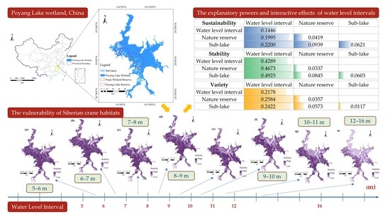
3.1. Spatial Variation of the Habitat Vulnerability

The vulnerabilities of Siberian crane habitats in Poyang Lake wetland were evaluated by three indicators—sustainability, stability, and variety—within various water level intervals. Figure 3 shows the distributions of the sustainable crane habitats in Poyang Lake wetland and two national nature reserves, respectively. Under the hydrological conditions of extremely low, low, and average water levels, the most sustainable habitats were mainly distributed in the Qianqiuhu sub-lakes of Poyang Lake, located on the west and south sides of Poyang Lake, and intensively aggregated in the Nanji wetland reserve and Poyang Lake reserve (Figure 3a–c). In the Nanji wetland reserve, they were distributed in the shallow butterfly-shaped lakes, which are away from the main lake area (Figure 3e–g), whereas in the Poyang Lake reserve, they were widely distributed around the sub-lakes and formed a structure with multiple “rings” (Figure 3i–k).
With water level interval increases, the areas of sustainable habitats exhibited a consistent tendency of gradually increasing and then sharply decreasing, both in Poyang Lake wetland and in the two reserves (Table 2). The area of sustainable habitats in Poyang Lake wetland reached the highest value of 1200.42 km2 with an interval of 10–11 m; for the area in the Poyang Lake reserve, the highest value was 203.10 km2. Regarding the area in the Nanji wetland reserve, the highest value was 169.27 km2 with an interval of 8–9 m. Nevertheless, from the water level interval of 11–12 m to that of 12–16 m, the sustainable habitats sharply decreased and even disappeared throughout the entire wetland (Figure 3d,h,l). The areas of sustainable habitats reduced from 902.28 to 47.51 km2 throughout the entire wetland, whereas the areas reduced from 118.35 to 14.91 km2 in the Nanji wetland reserve and from 144.53 to 25.55 km2 in the Poyang Lake reserve, respectively. Water level interval is a primary determinant of the sustainability of crane habitats in Poyang Lake wetland. A high-value water level was not conducive to maintaining a sustainable habitat, even in a nature reserve. A water level of 12 m was the potential upper threshold for sustainable crane habitat maintenance.
Figure 4 and Figure 5 demonstrate the stability and variety distributions of crane habitats within various water level intervals, respectively. Both exhibited similar spatial distribution characteristics. The areas with low-value stability and variety were mainly distributed in the main channels and several sub-lakes on the east and north sides of Poyang Lake. The stability and variety of crane habitats gradually decreased as the water level increased (Figure 4 and Figure 5). In the main lake of Poyang, particularly close to the main channels, the decrease was obvious and expansionary. The area with high-value stability in the west and south of Poyang Lake also gradually decreased with the water level increase (Figure 4), indicating that the relative suitability of the crane habitat was weakened. This characteristic was also found in the variety variation as the water level increased. The variety in the main lake area and main channels (mostly located in the non-habitat area) gradually decreased and expanded with the water level increase (Figure 5). The area proportions of the lowest and below-average stability values were obviously enlarged with the water level increase. More specifically, the proportions reached the highest values of 19.37% and 79.60% within a water level interval of 12–16 m, respectively. The area proportion of the below-average variety values also reached its highest value of 54.24% within an interval of 12–16 m. Water level increases significantly weakened the aggregation characteristic of the crane habitats in Poyang Lake wetland.

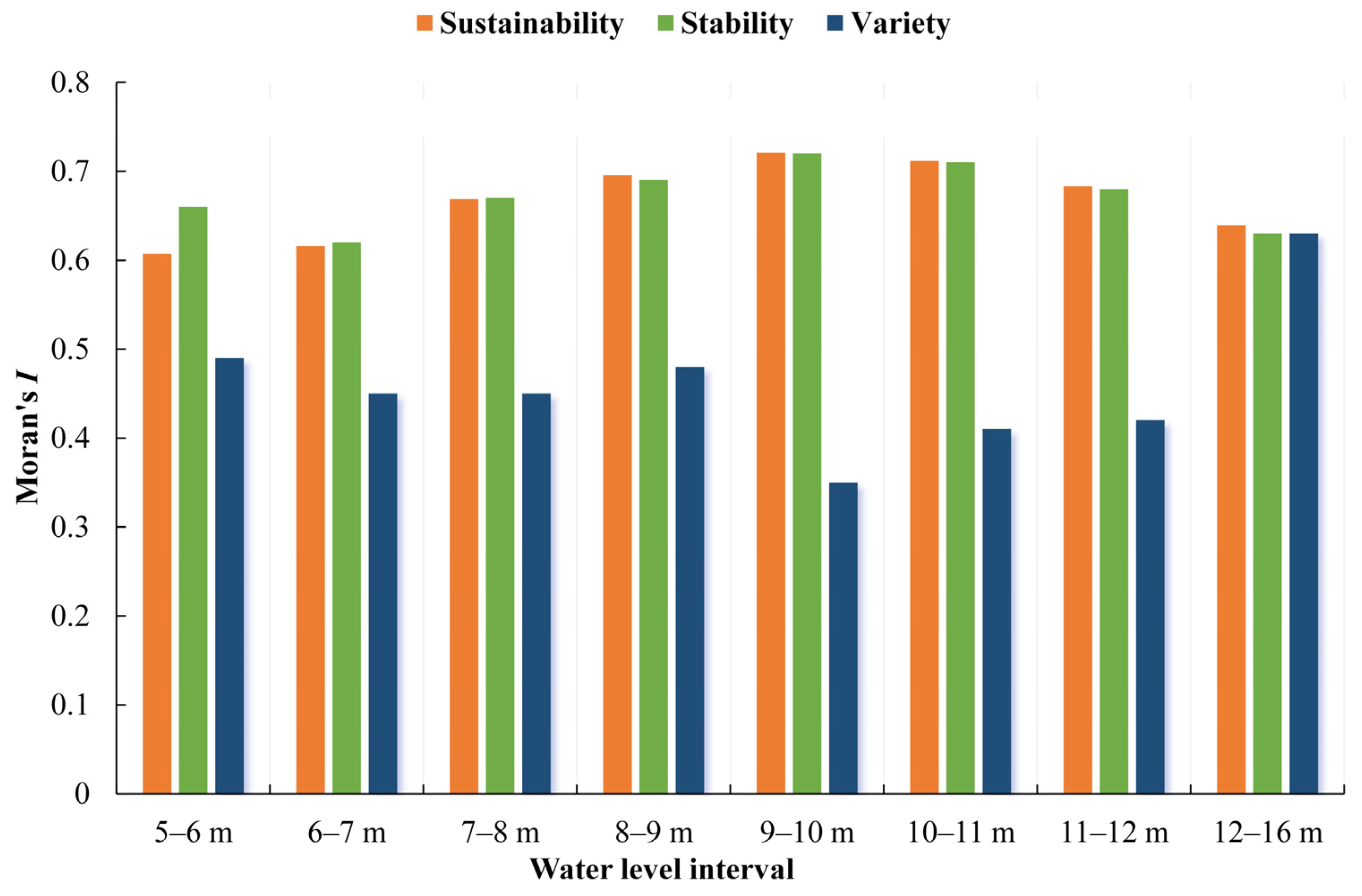
3.2. Spatial Distribution Pattern of the Habitat Vulnerability

Based on the vulnerability assessment datasets of the sustainability, stability, and variety of crane habitats, the Moran’s I and Getis–Ord G* indicators were applied to explore their global and local spatial autocorrelations within various water level intervals, respectively. Figure 6 shows the Moran’s I statistics of the sustainability, stability, and variety distributions, respectively. All Moran’s I statistics were statistically significant with an alpha level of 0.05. The values of Moran’s I statistics of the sustainability and stability distributions ranged from 0.61 to 0.72 and from 0.62 to 0.72, respectively, whereas that of the variety distribution ranged from 0.35 to 0.63. The vulnerability distributions of crane habitats in Poyang Lake wetland exhibited consistently strongly positive spatial autocorrelations, indicating significant spatial clustering characteristics within all water level intervals.
The spatial autocorrelations of the vulnerability distributions were sensitive to water level changes. As the water level increased, the Moran’s I statistics of the variety distribution slightly decreased and then increased, and the value change formed an obvious U-shaped curve (Figure 6). Meanwhile, as the water level increased, the Moran’s I statistics of the sustainability and stability distributions exhibited a consistent tendency of gradually increasing and then decreasing, and their value changes formed two similar inverse U-shaped curves opposite to that of the variety (Figure 6). It is worth noting that the highest values, as well as the lowest value of the variety, simultaneously appeared within the water interval of 9–10 m. Higher or lower water levels had the potential to weaken the spatial clustering characteristics of sustainable crane habitats and their stability. The water level interval of 9–10 m was expected to be an optimal interval for facilitating the aggregation features of crane habitats.
As shown in Figure 7, the hot spots of the sustainable crane habitats were obviously distributed in the Qianqiuhu sub-lakes of Poyang Lake and intensively aggregated in two reserves within various water level intervals, whereas the cold spots were expansionary from the main channels of Poyang Lake to the main lake area as the water level increased. However, both almost disappeared within the water level interval of 12–16 m. Nature reserves were conducive to maintaining the local clustering characteristic of the sustainable crane habitats, but the water level increase reduced the chances for other areas as potentially suitable habitats. Figure 8 demonstrates the geographical distributions of hot and cold spots of the stability of crane habitats within various water level intervals. The tendency with the water level increase was almost consistent with that of the sustainability. Although nature reserves played a great role in maintaining hot spots of the habitat stability, the dispersed hot spots in other areas gradually disappeared as the water level increased. The cold spots exhibited gradually expansionary tendencies as well; in particular, within the water level interval of 12–16 m, the entire main lake area nearly became cold spots with low-value stability clusters. Rare hot spots were revealed from the ‘variety’ distributions of crane habitats throughout the entire wetland, and no obvious association was found with water level changes (Figure 9). However, the cold spots were still mainly distributed around the main channels of Poyang Lake; more specifically, the dispersed cold spots aggregated into a contiguous area from the water level interval of 11–12 m to that of 12–16 m, which covered the majority of the main lake of Poyang. In short, the cold spots of the vulnerability distributions strengthened with the water level increase, whereas the hot spots were not significantly influenced due to the protection of nature reserves and others.

3.3. Explanatory Power of the Water Level Interval on Habitat Vulnerability

Evaluations of the sustainability, stability, and variety of crane habitats in Poyang Lake wetland varied among water level intervals, from nature reserves to other areas, and from sub-lakes to other areas (Figure 3, Figure 4 and Figure 5). The stratifications determined by water level intervals, nature reserves, and sub-lakes can be recognized as three explanatory variables to the habitat vulnerability and the corresponding explanatory powers can be explicitly examined. We calculated the geographical detector q-statistics of three stratifications (factors) for the sustainability, stability, and variety, respectively, as well as the interactive q-statistics of paired factors. Table 3 lists the results of the q-statistics of each individual factor and each pair of factors to three vulnerability indicators (the diagonal values denote the individual q-statistics of a factor and the lower triangular ones indicate the interactive q-statistics of each pair of two factors).
The water level interval was the most dominant factor in the vulnerability of crane habitats. The within-interval variance of the vulnerability was less than the between-interval variance. The q-statistics of water level intervals for the sustainability, stability, and variety, were 0.1446, 0.4289, and 0.2178, with an alpha level of 0.001, respectively (Table 3). In other words, the water level interval can explain 14.46% of the SSH of the sustainability, 42.89% of the SSH of the stability, and 21.78% of the SSH of the variety. Nature reserves and sub-lakes achieved very small values of q-statistics (q < 0.1) for all three vulnerability indicators. Their individual explanatory powers were quite weak on the vulnerability of crane habitats. Nevertheless, the interactive q-statistic for the sustainability was 0.0939, which was greater than both individual q-statistics but smaller than the sum of each individual effect; thus, they enhanced each other—in a bivariate manner—to explain the sustainability. Identical interactive enhancement was found for them, explaining the stability. Regarding the variety, the interactive q-statistic was greater than the sum of the two individual ones, indicating that they nonlinearly enhanced each other.
It is worth noting that the water level interval also played a great role in the interactive effect on the vulnerability of crane habitats. As shown in Table 3, the dominant interactive effect for the stability was the water level interval and the sub-lake (q = 0.4925), which was greater than the sum of two individual effects (q = 0.4289 and q = 0.0603, respectively). Their interactions can explain 49.25% of the SSH of the stability. The dominant interactive effect for the sustainability was also determined by the water level interval and the sub-lake, and the interaction can explain 22% of the SSH of the sustainability, which was greater than the sum of two individual effects (q = 0.1446 and q = 0.0621, respectively). Regarding the variety, the water level interval and the nature reserve provided the dominant interactive effect (q = 0.2584), which was also greater than the sum of two individual effects (q = 0.2178 and q = 0.0357, respectively). While interacting with other factors, the water level interval achieved interactive q-statistic values, which were always greater than the sum of two individual effects, indicating consistent and interactive nonlinear enhancement. Moreover, the dominant interactive effect for each vulnerability indicator was always identified by the interaction between it and another factor. That is to say, the water level interval also provided the most dominant interactive power for the vulnerability of crane habitats.

4. Discussion

The Poyang Lake wetland in China is internationally important and the largest bird conservation area in the world, providing important habitats for millions of wintering water bird species worldwide. More specifically, it is the largest wintering destination worldwide for Siberian cranes (one of the most endangered species in the world). Thus, the study of Siberian crane habitats in Poyang Lake wetland is of great importance to both China and the world.
The Siberian crane is a special species among the hundreds of wintering migratory birds at Poyang Lake. It is highly dependent on shallow water wetlands and has very stringent requirements concerning the ecological environments of its habitats. The water level change of Poyang Lake is expected to be a dominant factor affecting the suitable habitats of Siberian cranes and the corresponding vulnerabilities. This article focused on evaluating the habitat vulnerabilities of wintering migratory birds with more precise water level intervals, exploring the spatial variations and distribution patterns of the habitat vulnerabilities caused by various water level intervals, and quantifying the influences of water level changes on habitat vulnerabilities. The findings are of great significance for wetland ecosystem management and migratory bird habitat protection in Poyang Lake. We highlighted the importance of the service functions of the Poyang Lake wetland ecosystem as the habitats for Siberian cranes and elaborated on why the habitat availability of cranes highly depends on hydrological conditions in Poyang Lake wetland. We believe that this study provides a novel perspective in evaluating the habitat vulnerability of wintering migratory birds within precise water level intervals, quantifying the influence of water level changes on the habitat vulnerability in a typical wetland, and filling a conceptual gap in the field. Moreover, the proposed approaches can be easily extended to identify the suitable habitats of other wintering birds in other typical wetlands, evaluate the corresponding habitat vulnerabilities, and quantify the responses to water level changes, which fill methodological gaps. Moreover, it is worth noting that this article is a typical case study that supports sustainable development targets, regarding reducing the degradation of natural habitats, halting the loss of biodiversity, and protecting and preventing the extinction of threatened species [38].
In this study, we found that the vulnerabilities of Siberian crane habitats were significantly sensitive to the water level changes of Poyang Lake; this is consistent with several previous studies [9,14,21,32,34]. More specifically, as the water level increased, the stability and variety of Siberian crane habitats gradually decreased, whereas the sustainable habitats gradually increased and then sharply decreased; the spatial clustering characteristics of the variety distribution slightly decreased and then increased, whereas the sustainability and stability distributions gradually increased and then decreased. The findings also indicate that the water level interval was identified as the most dominant determinant of the vulnerability of crane habitats. It can explain 14.46%, 42.89%, and 21.78% of the sustainability, stability, and variety; the numbers were expected to enlarge to 22%, 49.25%, and 25.84%, respectively, with water level intervals interacting with other factors.
It is worth noting that two national nature reserves played a great role in maintaining the Siberian crane habitats in Poyang Lake wetland. The most sustainable habitats were intensively aggregated in nature reserves, and their hot spots showed obvious continuity within various water level intervals, especially in nature reserves. Moreover, due to the protection of nature reserves, the hot spots of the stability and variety distributions were not significantly influenced by water level changes. In this connection, strengthening the protection of nature reserves is of great importance in the protection of Siberian crane habitats. In recent years, the construction and protection of man-made wetlands in the Poyang Lake region have provided more habitats for wintering Siberian cranes [54,55]. Large areas of protected lotus roots in the Wuxing Siberian crane conservation zone have become important food sources for over 30% of the wintering Siberian cranes in Poyang Lake. Meanwhile, sand dredging activities (as typical human disturbances in Poyang Lake) were regulated with coordinated planning of the timing, location, and output, which significantly reduced the impacts on the Siberian crane habitats in the main lake area and close to the main channels. In addition to the current nature reserve management and man-made wetland construction, future conservation strategies should focus on improving the ecosystem service functions of Poyang Lake wetland, as the hydrological conditions in low-water seasons go through significant changes.
One of the main contributions of this study involved evaluating the habitat vulnerabilities of wintering migratory birds within 1-meter water level intervals in a typical wetland. The evaluation of the habitat vulnerabilities with precise water level intervals made it practical to identify the precise responses to water level changes. For instance, a water level of 12 m was identified as a potential upper threshold for the maintenance of sustainable crane habitats, and a water level interval of 9–10 m was expected to be an optimal interval for facilitating the aggregation features of crane habitats. Another main contribution was using the geographical detector method to quantitatively assess the explanatory powers of water level intervals and others on the habitat vulnerability, as well as the interactive effects of paired factors. The strongest explanatory power was from the interactive effects of the water level interval and the sub-lake on the stability.
This study has several limitations and we identified further analyses for future work. First, more variables can be introduced in future work to assess the explanatory powers on habitat vulnerabilities, including other geographical stratifications (e.g., man-made reserves and other areas), other categorical variables similar to water level intervals (e.g., temporal intervals), or even several numerical variables (e.g., meteorological factors). Second, due to the issues of data availability and suitability, the remote sensing images used in this study were not taken at regular temporal intervals in the past 30 years. By employing more multi-sourced images in future efforts, it could be possible to extend this study by introducing an additional factor of a specific temporal interval or by conducting a time series analysis of the habitat vulnerability.

5. Conclusions

This article is an empirical study that evaluated the habitat vulnerabilities of wintering migratory birds within precise water level intervals, quantifying the corresponding influences of water level changes in a typical wetland. It provides a novel perspective in the evaluation of the habitat vulnerabilities of wintering migratory birds and a response to water level changes in wetlands. The approaches are applicable and practicable for the habitat vulnerability assessments of other wintering birds in other typical wetlands.
The case study in this article evaluated the vulnerability of Siberian crane habitats in Poyang Lake wetland within 1-meter water level intervals, explored the spatial variations and distribution patterns of the habitat vulnerability, and quantified the explanatory powers of the water level interval and others on the habitat vulnerability. The findings include the following: (a) The sustainable crane habitats in Poyang Lake wetland exhibited consistent tendencies of gradually increasing and then sharply decreasing as the water level increased. A water level of 12 m was a potential upper threshold for the maintenance of sustainable crane habitats. (b) The stability and variety of crane habitats gradually decreased as the water level increased; the decrease was obvious and expansionary in the main lake of Poyang, particularly close to the main channels. (c) The vulnerability distributions exhibited consistent spatial clustering characteristics within all water level intervals. However, as the water level increased, the characteristics of the variety exhibited U-shaped tendencies, whereas those of sustainability and stability exhibited inverse U-shaped tendencies. The water level interval of 9–10 m was expected to be an optimal interval for facilitating the aggregation features of crane habitats. (d) The cold spots of vulnerability distributions strengthened with the water level increase, whereas the hot spots were not significantly influenced due to the protection of nature reserves and others. (e) The water level interval was the most dominant factor for habitat vulnerability, which had much stronger explanatory powers than the nature reserve and sub-lake factors. (f) The water level interval also provided the most dominant interactive effects for the sustainability, stability, and variety of crane habitats, achieving a consistent and interactive nonlinear enhancement when interacting with other factors.

Supplementary Materials

The following supporting information can be downloaded at: https://www.mdpi.com/article/10.3390/rs14122774/s1, Figure S1: Poyang Lake wetland landscapes with the extremely low water level (EL); Figure S2: Poyang Lake wetland landscapes with the low water level (LL); Figure S3: Poyang Lake wetland landscapes with the average water level (AL); Figure S4: Poyang Lake wetland landscapes with the high water level (HL).

Author Contributions

Conceptualization, B.H. and S.Q.; methodology, B.H.; software, L.Z. (Lin Zou) and B.H.; validation, B.H., Q.Y. and J.L.; formal analysis, L.Z. (Lin Zou), Q.Y. and B.H.; investigation, Q.Y. and J.L.; resources, S.Q. and B.H.; data curation, B.H., J.L., L.Z. (Lijun Zuo) and Y.M.; writing—original draft preparation, B.H.; writing—review and editing, B.H. and S.Q.; visualization, L.Z. (Lin Zou), Q.Y., J.L., L.Z. (Lijun Zuo) and Y.M.; supervision, B.H.; funding acquisition, B.H. and S.Q. All authors have read and agreed to the published version of the manuscript, and have final responsibility for the decision to submit for publication.

Funding

This research was funded by the National Natural Science Foundation of China (grant numbers 42061075 and 41867012) and the Strategic Priority Research Program of the Chinese Academy of Sciences (grant number XDA19090124).

Data Availability Statement

The data presented in this study are available upon request from the corresponding author. The data are not publicly available due to the constraint in the consent.

Conflicts of Interest

The authors declare no conflict of interest. The funders had no role in the design of the study; in the collection, analyses, or interpretation of data; in the writing of the manuscript, or in the decision to publish the results.

References

  1. Wang, Y. Poyang Lake and wintering Siberian cranes. Front. Ecol. Environ. 2020, 18, 100. [Google Scholar] [CrossRef] [Green Version]
  2. Li, F.; Wu, J.; Harris, J.; Burnham, J. Number and distribution of cranes wintering at Poyang Lake, China during 2011–2012. Chin. Birds 2012, 3, 180–190. [Google Scholar] [CrossRef] [Green Version]
  3. Dronova, I.; Beissinger, S.; Burnham, J.; Gong, P. Landscape-Level Associations of Wintering Waterbird Diversity and Abundance from Remotely Sensed Wetland Characteristics of Poyang Lake. Remote Sens. 2016, 8, 462. [Google Scholar] [CrossRef] [Green Version]
  4. Xia, S.; Wang, Y.; Lei, G.; Liu, Y.; Lei, J.; Yu, X.; Wen, L.; Zhou, Y. Restriction of Herbivorous Waterbird Distributions in the Middle and Lower Yangtze River Floodplain in View of Hydrological Isolation. Wetlands 2017, 37, 79–88. [Google Scholar] [CrossRef]
  5. Feng, L.; Hu, C.; Chen, X.; Zhao, X. Dramatic Inundation Changes of China’s Two Largest Freshwater Lakes Linked to the Three Gorges Dam. Environ. Sci. Technol. 2013, 47, 9628–9634. [Google Scholar] [CrossRef]
  6. Lai, X.; Jiang, J.; Yang, G.; Lu, X.X. Should the Three Gorges Dam be blamed for the extremely low water levels in the middle-lower Yangtze River? Hydrol. Process. 2014, 28, 150–160. [Google Scholar] [CrossRef]
  7. Wang, Q.; Zhang, M.; Wang, S.; Ma, Q.; Sun, M. Changes in temperature extremes in the Yangtze River Basin, 1962–2011. J. Geogr. Sci. 2014, 24, 59–75. [Google Scholar] [CrossRef]
  8. Mei, X.; Dai, Z.; Fagherazzi, S.; Chen, J. Dramatic variations in emergent wetland area in China’s largest freshwater lake, Poyang Lake. Adv. Water Resour. 2016, 96, 1–10. [Google Scholar] [CrossRef] [Green Version]
  9. Jiang, F.; Qi, S.; Liao, F.; Ding, M.; Wang, Y. Vulnerability of Siberian crane habitat to water level in Poyang Lake wetland, China. GIScience Remote Sens. 2014, 51, 662–676. [Google Scholar] [CrossRef]
  10. Hou, J.; Liu, Y.; Fraser, J.D.; Li, L.; Zhao, B.; Lan, Z.; Jin, J.; Liu, G.; Dai, N.; Wang, W. Drivers of a habitat shift by critically endangered Siberian cranes: Evidence from long-term data. Ecol. Evol. 2020, 10, 11055–11068. [Google Scholar] [CrossRef] [PubMed]
  11. Liu, H.; Yuan, H.; Wang, S.; Zheng, L.; Liao, M. Spatiotemporal Dynamics of Water Body Changes and Their Influencing Factors in the Seasonal Lakes of the Poyang Lake Region. Water 2021, 13, 1539. [Google Scholar] [CrossRef]
  12. Hu, Z.; Zhang, Z.; Liu, Y.; Ji, W.; Ge, G. The function and significance of the shallow-lakes in the Poyang Lake wetland ecosystem. Jiangxi Hydraul. Sci. Technol. 2015, 41, 317–323. (In Chinese) [Google Scholar]
  13. Baschuk, M.S.; Koper, N.; Wrubleski, D.A.; Goldsborough, G. Effects of Water Depth, Cover and Food Resources on Habitat use of Marsh Birds and Waterfowl in Boreal Wetlands of Manitoba, Canada. Waterbirds 2012, 35, 44–55. [Google Scholar] [CrossRef]
  14. Li, Y.; Qian, F.; Silbernagel, J.; Larson, H. Community structure, abundance variation and population trends of waterbirds in relation to water level fluctuation in Poyang Lake. J. Gt. Lakes Res. 2019, 45, 976–985. [Google Scholar] [CrossRef]
  15. Wang, C.; Wang, G.; Dai, L.; Liu, H.; Li, Y.; Zhou, Y.; Chen, H.; Dong, B.; Lv, S.; Zhao, Y. Diverse usage of waterbird habitats and spatial management in Yancheng coastal wetlands. Ecol. Indic. 2020, 117, 106583. [Google Scholar] [CrossRef]
  16. Xu, H.; Zhao, S.; Song, N.; Liu, N.; Zhong, S.; Li, B.; Wang, T. Abundance and behavior of little egrets (Egretta garzetta) near an onshore wind farm in Chongming Dongtan, China. J. Clean. Prod. 2021, 312, 127662. [Google Scholar] [CrossRef]
  17. Cheng, L.; Zhou, L.; Wu, L.; Feng, G. Nest site selection and its implications for conservation of the endangered Oriental Stork Ciconia boyciana in Yellow River Delta, China. Bird Conserv. Int. 2020, 30, 323–334. [Google Scholar] [CrossRef]
  18. Jourdan, C.; Fort, J.; Pinaud, D.; Delaporte, P.; Gernigon, J.; Lachaussée, N.; Lemesle, J.-C.; Pignon-Mussaud, C.; Pineau, P.; Robin, F.; et al. Nycthemeral Movements of Wintering Shorebirds Reveal Important Differences in Habitat Uses of Feeding Areas and Roosts. Estuaries Coasts 2021, 44, 1454–1468. [Google Scholar] [CrossRef]
  19. Schwemmer, P.; Weiel, S.; Garthe, S. Spatio-temporal movement patterns and habitat choice of red foxes (Vulpes vulpes) and racoon dogs (Nyctereutes procyonoides) along the Wadden Sea coast. Eur. J. Wildl. Res. 2021, 67, 49. [Google Scholar] [CrossRef]
  20. Rasool, M.A.; Hassan, M.A.; Zhang, X.; Zeng, Q.; Jia, Y.; Wen, L.; Lei, G. Habitat Quality and Social Behavioral Association Network in a Wintering Waterbirds Community. Sustainability 2021, 13, 6044. [Google Scholar] [CrossRef]
  21. Chen, B.; Cui, P.; Xu, H.; Lu, X.; Lei, J.; Wu, Y.; Shao, M.; Ding, H.; Wu, J.; Cao, M.; et al. Assessing the Suitability of Habitat for Wintering Siberian Cranes (Leucogeranus leucogeranus) at Different Water Levels in Poyang Lake Area, China. Pol. J. Ecol. 2016, 64, 84–97. [Google Scholar] [CrossRef]
  22. Wang, C.; Liu, H.; Li, Y.; Dong, B.; Qiu, C.; Yang, J.; Zong, Y.; Chen, H.; Zhao, Y.; Zhang, Y. Study on habitat suitability and environmental variable thresholds of rare waterbirds. Sci. Total Environ. 2021, 785, 147316. [Google Scholar] [CrossRef] [PubMed]
  23. Huang, Z.; Lu, L.; Jiao, G.; Jiang, J.; Ye, Q. Analysis of the correlations between environmental factors and rare cranes in the Poyang Lake region of China. J. Gt. Lakes Res. 2018, 44, 140–148. [Google Scholar] [CrossRef]
  24. Bao, K.; Liu, J.; Meng, B.; Sun, B. The Effects of Hydrological Conditions on Eco-Exergy of Food Webs in Momoge National Nature Reserve, China. Wetlands 2019, 39, 601–617. [Google Scholar] [CrossRef]
  25. Jia, Y.; Jiao, S.; Zhang, Y.; Zhou, Y.; Lei, G.; Liu, G. Diet Shift and Its Impact on Foraging Behavior of Siberian Crane (Grus Leucogeranus) in Poyang Lake. PLoS ONE 2013, 8, e65843. [Google Scholar] [CrossRef]
  26. Burnham, J.; Barzen, J.; Pidgeon, A.M.; Sun, B.; Wu, J.; Liu, G.; Jiang, H. Novel foraging by wintering Siberian Cranes Leucogeranus leucogeranus at China’s Poyang Lake indicates broader changes in the ecosystem and raises new challenges for a critically endangered species. Bird Conserv. Int. 2017, 27, 204–223. [Google Scholar] [CrossRef] [Green Version]
  27. Herbert, J.A.; Chakraborty, A.; Naylor, L.W.; Beatty, W.S.; Krementz, D.G. Effects of landscape structure and temporal habitat dynamics on wintering mallard abundance. Landsc. Ecol. 2018, 33, 1319–1334. [Google Scholar] [CrossRef]
  28. Zhang, L.; Dong, T.; Xu, W.; Ouyang, Z. Assessment of habitat fragmentation caused by traffic networks and identifying key affected areas to facilitate rare wildlife conservation in China. Wildl. Res. 2015, 42, 266. [Google Scholar] [CrossRef] [Green Version]
  29. Zhang, Y.; Fox, A.D.; Cao, L.; Jia, Q.; Lu, C.; Prins, H.H.T.; de Boer, W.F. Effects of ecological and anthropogenic factors on waterbird abundance at a Ramsar Site in the Yangtze River Floodplain. Ambio 2019, 48, 293–303. [Google Scholar] [CrossRef]
  30. Lehikoinen, A.; Jaatinen, K.; Vähätalo, A.V.; Clausen, P.; Crowe, O.; Deceuninck, B.; Hearn, R.; Holt, C.A.; Hornman, M.; Keller, V.; et al. Rapid climate driven shifts in wintering distributions of three common waterbird species. Glob. Chang. Biol. 2013, 19, 2071–2081. [Google Scholar] [CrossRef]
  31. Zhang, C.; Yuan, Y.; Zeng, G.; Liang, J.; Guo, S.; Huang, L.; Hua, S.; Wu, H.; Zhu, Y.; An, H.; et al. Influence of hydrological regime and climatic factor on waterbird abundance in Dongting Lake Wetland, China: Implications for biological conservation. Ecol. Eng. 2016, 90, 473–481. [Google Scholar] [CrossRef]
  32. Li, C.; Yang, Y.; Wang, Z.; Yang, L.; Zhang, D.; Zhou, L. The relationship between seasonal water level fluctuation and habitat availability for wintering waterbirds at Shengjin Lake, China. Bird Conserv. Int. 2019, 29, 100–114. [Google Scholar] [CrossRef]
  33. Fan, Z.; Wang, Z.; Li, Y.; Wang, W.; Tang, C.; Zeng, F. Water Level Fluctuation under the Impact of Lake Regulation and Ecological Implication in Huayang Lakes, China. Water 2020, 12, 702. [Google Scholar] [CrossRef] [Green Version]
  34. Zou, L.; Hu, B.; Qi, S.; Zhang, Q.; Ning, P. Spatiotemporal Variation of Siberian Crane Habitats and the Response to Water Level in Poyang Lake Wetland, China. Remote Sens. 2021, 13, 140. [Google Scholar] [CrossRef]
  35. Han, X.; Feng, L.; Hu, C.; Chen, X. Wetland changes of China’s largest freshwater lake and their linkage with the Three Gorges Dam. Remote Sens. Environ. 2018, 204, 799–811. [Google Scholar] [CrossRef]
  36. Zhao, S.; Xu, H.; Song, N.; Wang, Z.; Li, B.; Wang, T. Effect of wind farms on wintering ducks at an important wintering ground in China along the East Asian–Australasian Flyway. Ecol. Evol. 2020, 10, 9567–9580. [Google Scholar] [CrossRef]
  37. Li, Y.; Zhong, Y.; Shao, R.; Yan, C.; Jin, J.; Shan, J.; Li, F.; Ji, W.; Bin, L.; Zhang, X.; et al. Modified hydrological regime from the Three Gorges Dam increases the risk of food shortages for wintering waterbirds in Poyang Lake. Glob. Ecol. Conserv. 2020, 24, e01286. [Google Scholar] [CrossRef]
  38. Hu, B.; Qi, S.; Luo, J.; Lin, H. Monitoring Spatiotemporal Variations of Wintering Siberian crane Habitats. In Big Earth Data in Support of the Sustainable Development Goals (2021); 2021; pp. 126–128. Available online: https://www.fmprc.gov.cn/mfa_eng/topics_665678/2030kcxfzyc/202109/P020211019152777729038.pdf (accessed on 8 December 2021).
  39. Yao, S.; Li, X.; Liu, C.; Zhang, J.; Li, Y.; Gan, T.; Liu, B.; Kuang, W. New assessment indicator of habitat suitability for migratory bird in wetland based on hydrodynamic model and vegetation growth threshold. Ecol. Indic. 2020, 117, 106556. [Google Scholar] [CrossRef]
  40. Hui, F.; Xu, B.; Huang, H.; Yu, Q.; Gong, P. Modelling spatial-temporal change of Poyang Lake using multitemporal Landsat imagery. Int. J. Remote Sens. 2008, 29, 5767–5784. [Google Scholar] [CrossRef]
  41. Liu, Y.; Fan, N.; Yu, X.; Xia, S.; Qi, S. Identification of Wetland Boundaries of Poyang Lake and Analysis of Seasonal Change Based on Remote Sensing and GIS technology. Resour. Sci. 2010, 32, 2239–2245. (In Chinese) [Google Scholar]
  42. Guo, H.; Hu, B.; Li, Q. Effects of autumn fishery by Enclosing Plate-Shaped Lake on the winter migratory birds and conservation strategies in Nanji Wetland National Natural Reserve of the Poyang Lake, Jiangxi. Resour. Environ. Yangtze Basin 2014, 23, 46–52. (In Chinese) [Google Scholar]
  43. Geospatial Data Cloud. Available online: http://www.gscloud.cn/home (accessed on 8 December 2021).
  44. Hou, J.; Li, L.; Wang, Y.; Wang, W.; Zhan, H.; Dai, N.; Lu, P. Influences of submerged plant collapse on diet composition, breadth, and overlap among four crane species at Poyang Lake, China. Front. Zool. 2021, 18, 24. [Google Scholar] [CrossRef] [PubMed]
  45. Zhu, Z.; Huai, W.; Yang, Z.; Li, D.; Wang, Y. Assessing habitat suitability and habitat fragmentation for endangered Siberian cranes in Poyang Lake region, China. Ecol. Indic. 2021, 125, 107594. [Google Scholar] [CrossRef]
  46. Qi, J.; Liu, H.; Liu, X.; Zhang, Y. Spatiotemporal evolution analysis of time-series land use change using self-organizing map to examine the zoning and scale effects. Comput. Environ. Urban Syst. 2019, 76, 11–23. [Google Scholar] [CrossRef]
  47. Moran, P.A.P. Notes on Continuous Stochastic Phenomena. Biometrika 1950, 37, 17–23. [Google Scholar] [CrossRef] [PubMed]
  48. Getis, A.; Ord, J.K. The Analysis of Spatial Association by Use of Distance Statistics. Geogr. Anal. 1992, 24, 189–206. [Google Scholar] [CrossRef]
  49. Wang, J.; Zhang, T.; Fu, B. A measure of spatial stratified heterogeneity. Ecol. Indic. 2016, 67, 250–256. [Google Scholar] [CrossRef]
  50. Wang, J.; Li, X.; Christakos, G.; Liao, Y.; Zhang, T.; Gu, X.; Zheng, X. Geographical Detectors-Based Health Risk Assessment and its Application in the Neural Tube Defects Study of the Heshun Region, China. Int. J. Geogr. Inf. Sci. 2010, 24, 107–127. [Google Scholar] [CrossRef]
  51. Yin, Q.; Wang, J.; Ren, Z.; Li, J.; Guo, Y. Mapping the increased minimum mortality temperatures in the context of global climate change. Nat. Commun. 2019, 10, 4640. [Google Scholar] [CrossRef] [Green Version]
  52. Xu, B.; Wang, J.; Li, Z.; Xu, C.; Liao, Y.; Hu, M.; Yang, J.; Lai, S.; Wang, L.; Yang, W. Seasonal association between viral causes of hospitalised acute lower respiratory infections and meteorological factors in China: A retrospective study. Lancet Planet. Health 2021, 5, e154–e163. [Google Scholar] [CrossRef]
  53. Hu, M.; Lin, H.; Wang, J.; Xu, C.; Tatem, A.J.; Meng, B.; Zhang, X.; Liu, Y.; Wang, P.; Wu, G.; et al. Risk of Coronavirus Disease 2019 Transmission in Train Passengers: An Epidemiological and Modeling Study. Clin. Infect. Dis. 2021, 72, 604–610. [Google Scholar] [CrossRef] [PubMed]
  54. Hou, J.; Wang, Y.; Jing, B.; Wang, L.; Wang, W. Food composition of Siberian cranes in agricultural fields in the Poyang Lake, China. Chin. J. Zool. 2019, 54, 15–21. (In Chinese) [Google Scholar] [CrossRef]
  55. Wang, W.; Wang, L.; Hou, J. Man-made habitats have become important foraging areas of Siberian cranes. Chin. J. Wildl. 2019, 40, 133–137. (In Chinese) [Google Scholar]
Figure 1. Locations of Poyang Lake wetland, sub-lakes, and two national nature reserves.
Remotesensing 14 02774 g001
Figure 2. Poyang Lake wetland landscapes with various water levels (EL: extremely low level; LL: low level; AL: average level; HL: high level). See Figures S1–S4 for the detailed landscapes within all water level intervals.
Remotesensing 14 02774 g002
Figure 3. Distributions of the sustainable crane habitats in: (ad) Poyang Lake wetland; (eh) Nanji wetland reserve; and (il) Poyang Lake reserve.
Remotesensing 14 02774 g003
Figure 4. Stabilities of crane habitats within various water level intervals: (a) 5–6 m; (b) 6–7 m; (c) 7–8 m; (d) 8–9 m; (e) 9–10 m; (f) 10–11 m; (g) 11–12 m; (h) 12–16 m.
Remotesensing 14 02774 g004
Figure 5. Varieties of crane habitats within various water level intervals: (a) 5–6 m; (b) 6–7 m; (c) 7–8 m; (d) 8–9 m; (e) 9–10 m; (f) 10–11 m; (g) 11–12 m; (h) 12–16 m.
Remotesensing 14 02774 g005
Figure 6. Global Moran’s I statistics of the vulnerability distributions of crane habitats within various water level intervals.
Remotesensing 14 02774 g006
Figure 7. Hot and cold spots of the sustainable crane habitats within various water level intervals: (a) 5–6 m; (b) 6–7 m; (c) 7–8 m; (d) 8–9 m; (e) 9–10 m; (f) 10–11 m; (g) 11–12 m; (h) 12–16 m.
Remotesensing 14 02774 g007
Figure 8. Hot and cold spots of the stabilities of crane habitats within various water level intervals: (a) 5–6 m; (b) 6–7 m; (c) 7–8 m; (d) 8–9 m; (e) 9–10 m; (f) 10–11 m; (g) 11–12 m; (h) 12–16 m.
Remotesensing 14 02774 g008
Figure 9. Hot and cold spots of the varieties of crane habitats within various water level intervals: (a) 5–6 m; (b) 6–7 m; (c) 7–8 m; (d) 8–9 m; (e) 9–10 m; (f) 10–11 m; (g) 11–12 m; (h) 12–16 m.
Remotesensing 14 02774 g009
Table 1. Landsat TM/ETM+/OLI images used in this study and the corresponding water levels at the Xingzi gauging station.
Water Level IntervalImage Acquired Date (DD/MM/YYYY)SensorWater Level at Xingzi Station (Yellow Sea Elevation)
5–6 m15 February 2004TM5.30 m
6 January 2007TM5.88 m
14 January 2010TM5.96 m
9 January 2014ETM+5.80 m
13 February 2015OLI5.81 m
6–7 m31 January 1993TM6.69 m
8 January 2002TM6.75 m
21 December 2006TM6.68 m
9 December 2010ETM+6.16 m
9 December 2011ETM+6.91 m
19 December 2017OLI6.32 m
7–8 m7 December 1995TM7.45 m
27 January 2000TM7.91 m
15 December 2004TM7.10 m
16 December 2016OLI7.40 m
8–9 m10 December 1999TM8.80 m
29 November 2004TM8.13 m
10 December 2008TM8.28 m
10 April 2018OLI8.02 m
9–10 m29 January 2001TM9.76 m
14 November 2012ETM+9.38 m
10 January 2013ETM+9.16 m
10–11 m5 March 2005TM10.10 m
8 March 2003ETM+10.82 m
16 March 2009TM10.72 m
11–12 m16 November 1999TM11.10 m
11 October 2015OLI11.46 m
9 May 2017OLI11.35 m
23 January 2019OLI11.48 m
12–16 m2 November 1994TM12.10 m
5 July 2000ETM+15.60 m
9 October 2000ETM+14.20 m
5 October 2007TM13.00 m
14 March 2020OLI12.06 m
Table 2. Areas of the sustainable crane habitats in Poyang Lake wetland and two national nature reserves within various water level intervals (km2).
Water Level IntervalPoyang Lake WetlandNanji Wetland ReservePoyang Lake Reserve
5–6 m903.52144.56131.94
6–7 m698.18103.4385.55
7–8 m1085.00149.75141.07
8–9 m1119.43169.27161.15
9–10 m1095.72164.52166.82
10–11 m1200.42159.90203.10
11–12 m902.28118.35144.53
12–16 m47.5114.9125.55
Table 3. Explanatory powers and the paired interactive effects of the water level interval, nature reserve, and sub-lake on the vulnerability of crane habitats.
Sustainability
Water level intervalNature reserveSub-lake
Water level interval0.1446
Nature reserve0.19950.0419
Sub-lake0.22000.09390.0621
Stability
Water level intervalNature reserveSub-lake
Water level interval0.4289
Nature reserve0.4673 0.0337
Sub-lake0.49250.08450.0603
Variety
Water level intervalNature reserveSub-lake
Water level interval0.2178
Nature reserve0.25840.0357
Sub-lake0.24220.05730.0117
 p < 0.001.
Publisher’s Note: MDPI stays neutral with regard to jurisdictional claims in published maps and institutional affiliations.

