
Displacement Back Analysis of Reservoir Landslide Based on Multi-Source Monitoring Data: A Case Study of the Cheyiping Landslide in the Lancang River Basin, China

 , ,
, ,
Abstract
:
1. Introduction
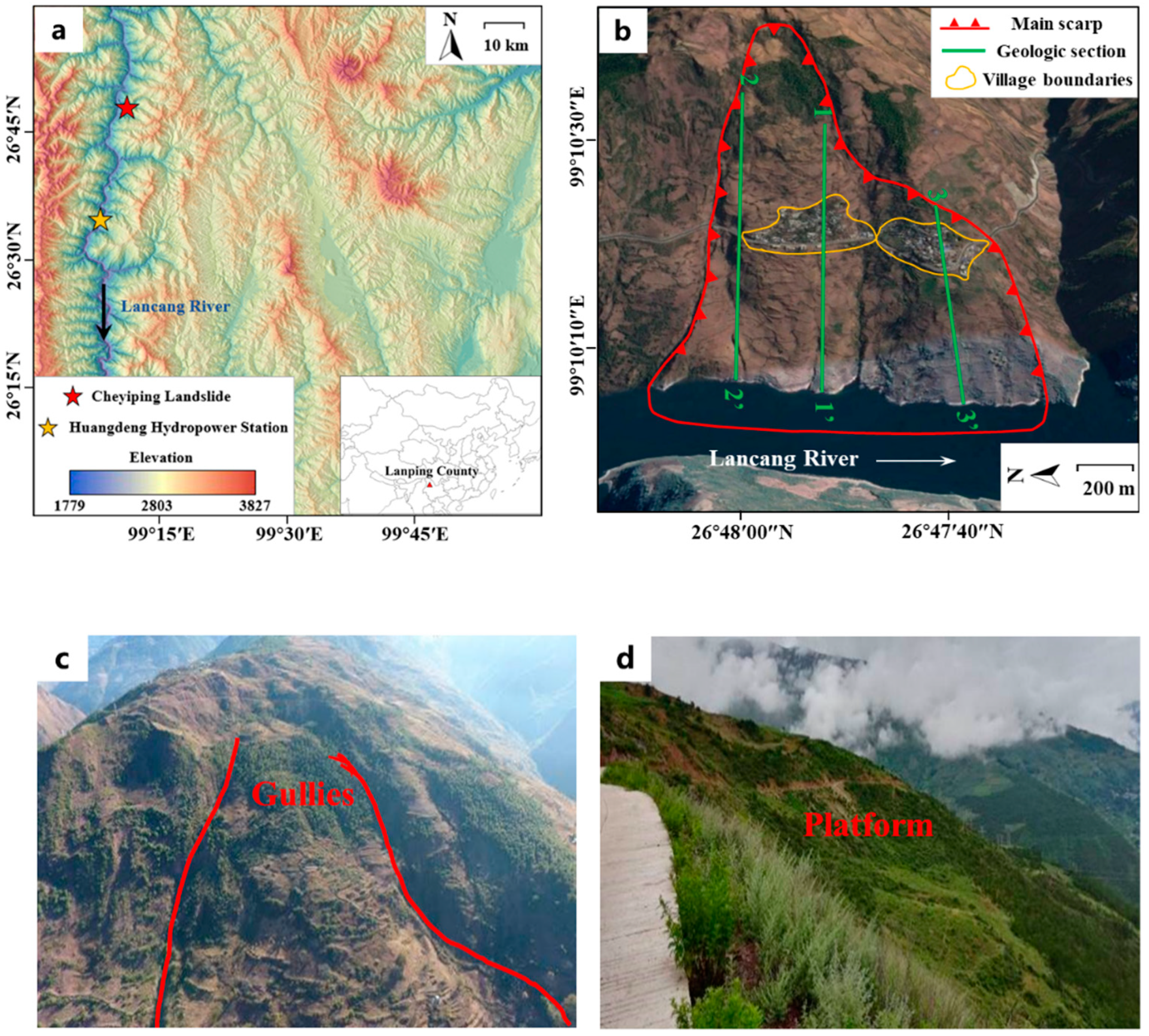
2. Study Area
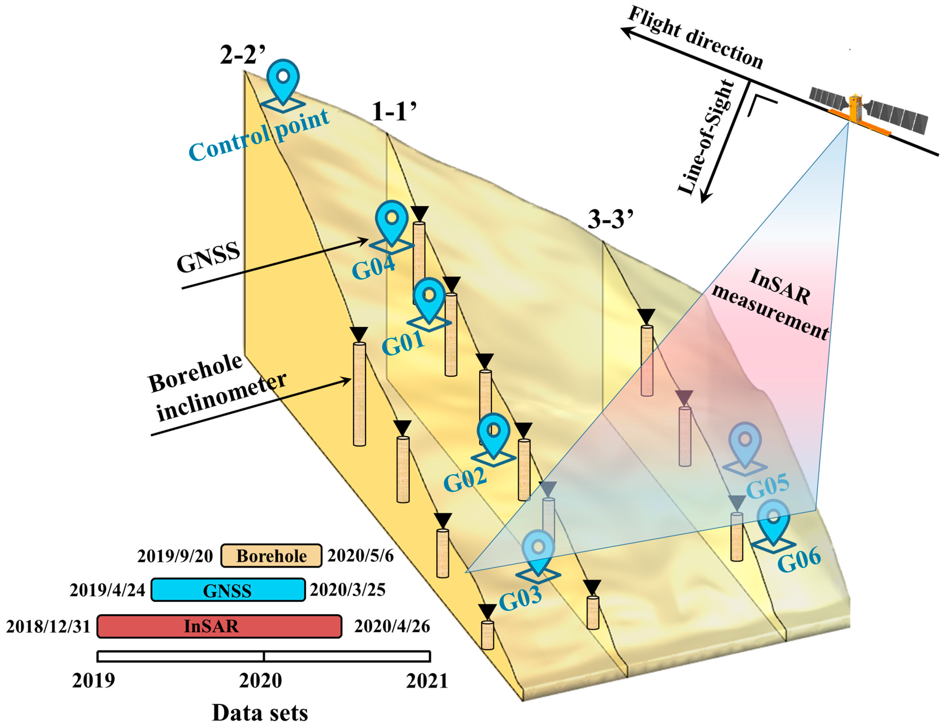
3. Data and Methods
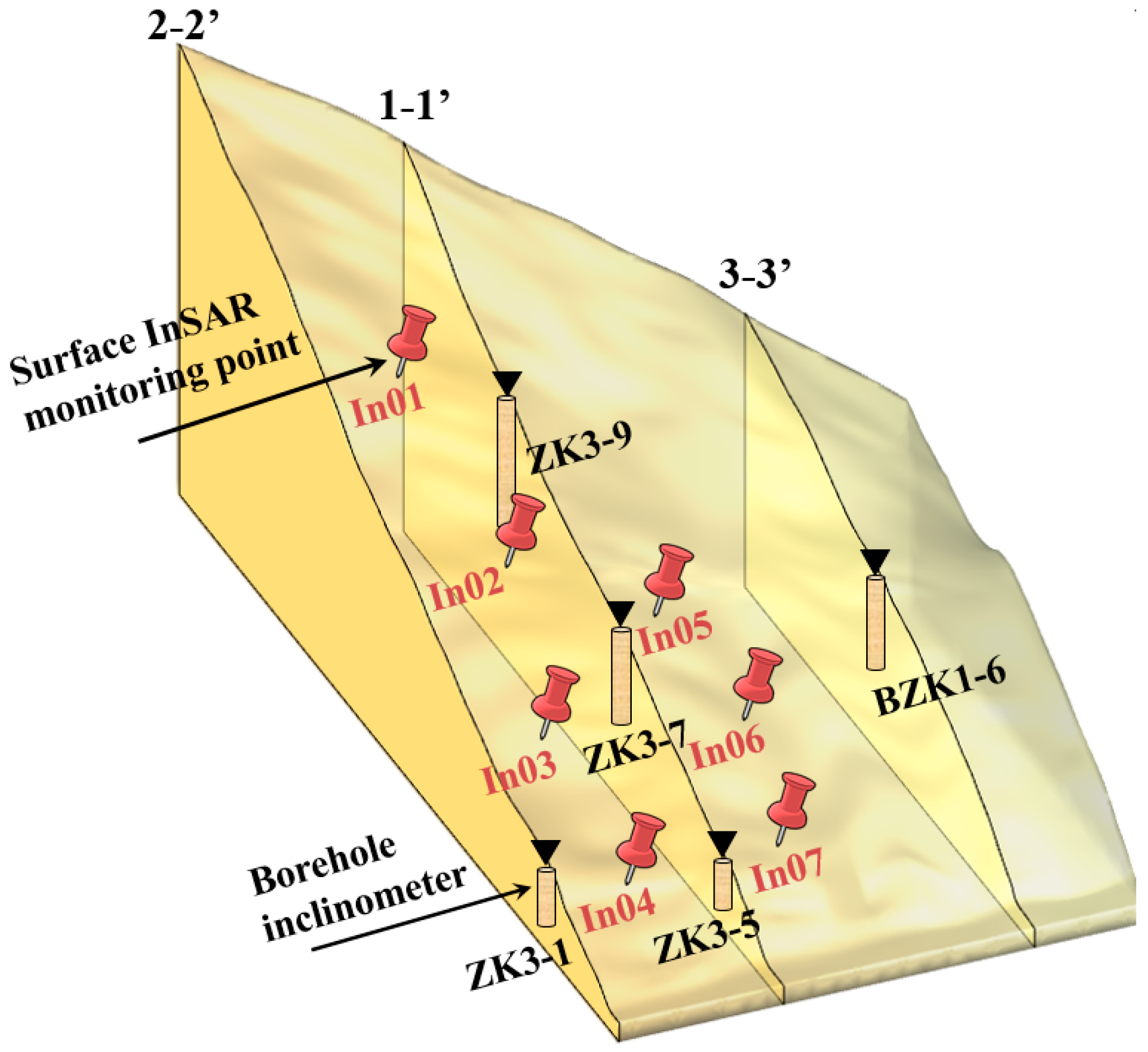
3.1. InSAR Measurements
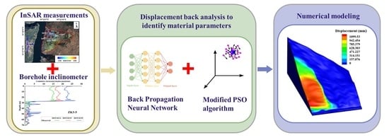
3.2. Displacement Back Analysis to Identify Material Parameters
4. Results and Discussion
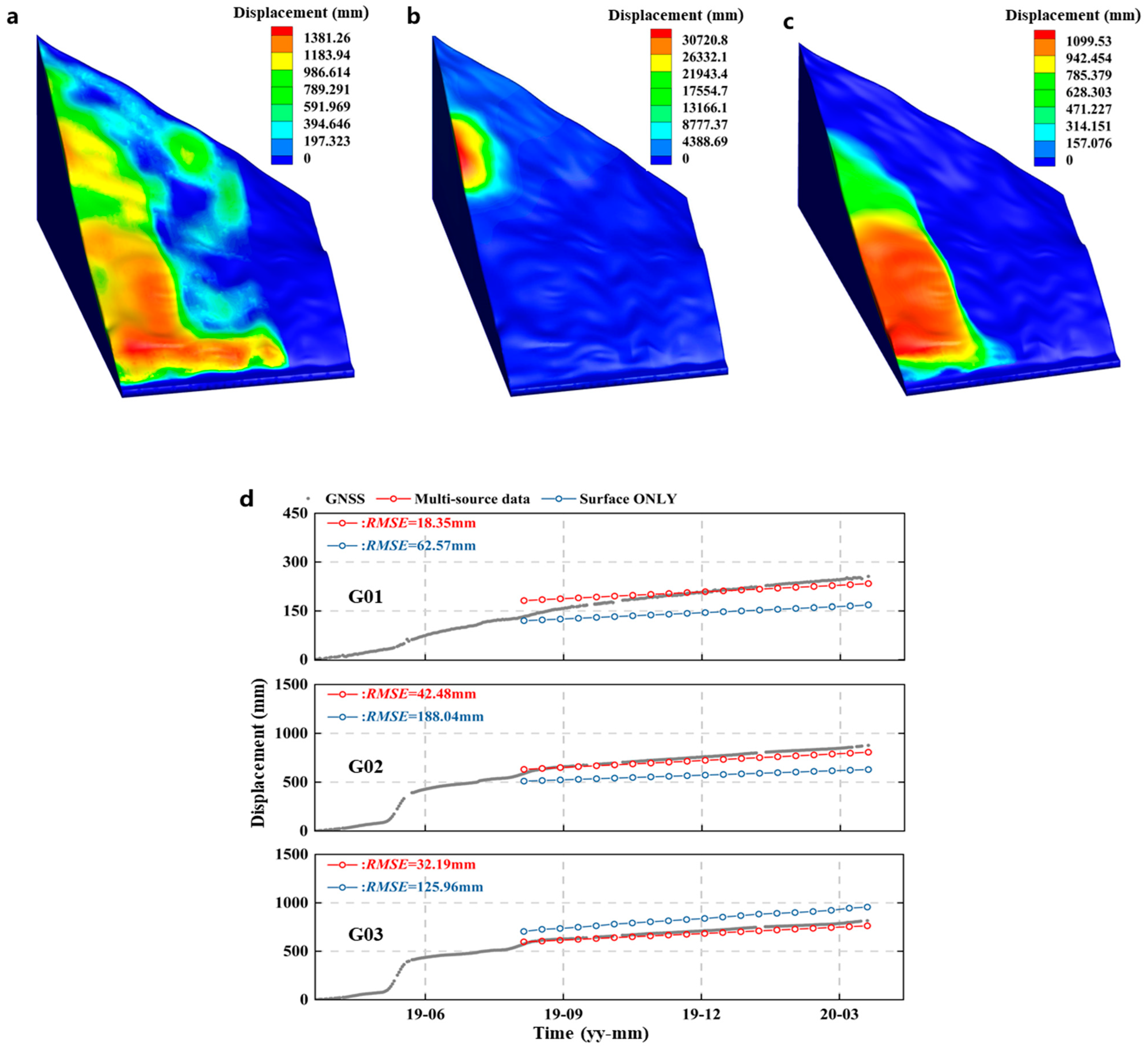
4.1. Displacement Back Analysis Using Multi-Source Monitoring Data
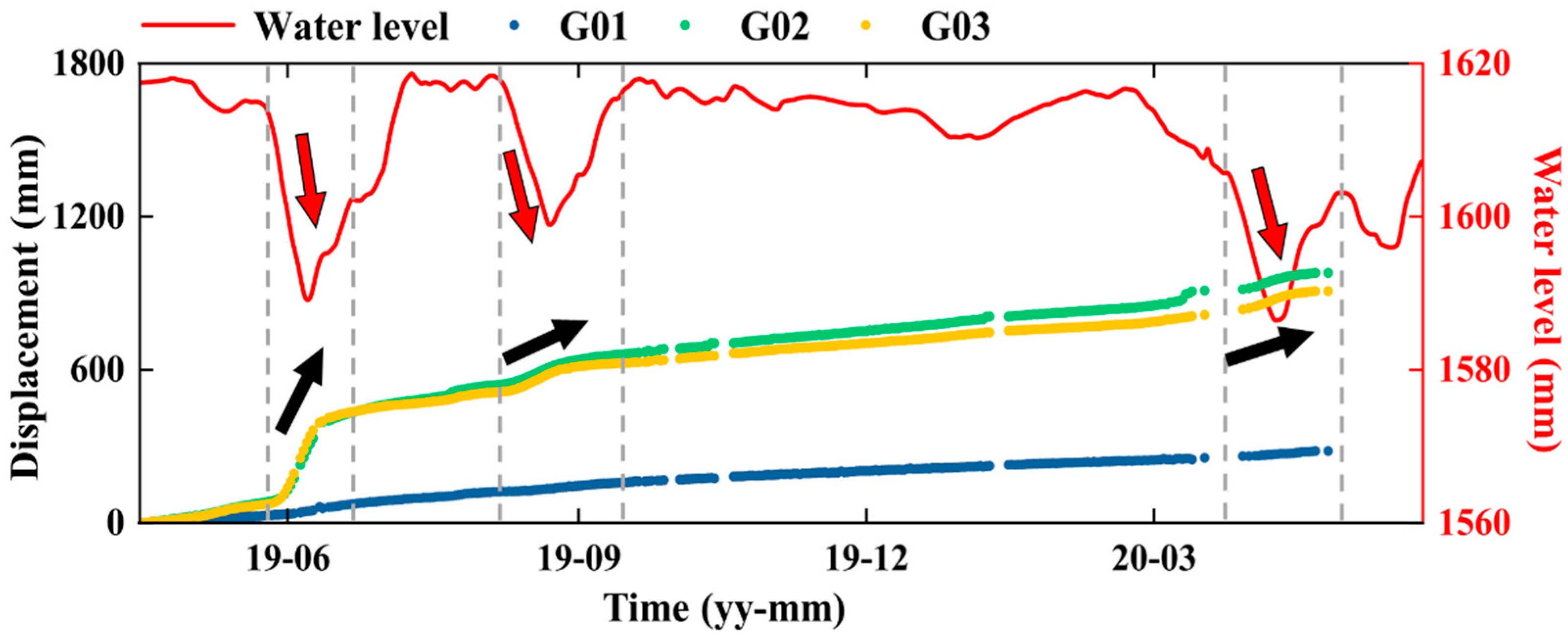
4.2. Deformation Characterristics and Triggering Factors of the Cheyiping Landslide
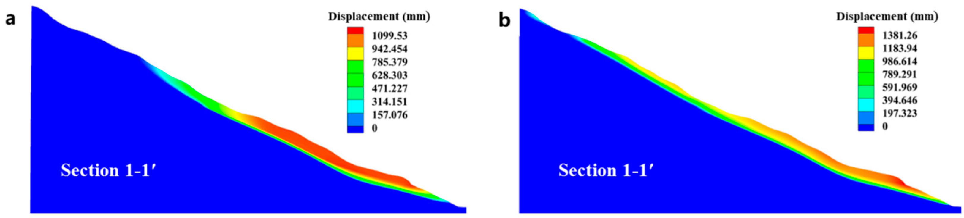
4.3. Further Application of Multi-Source Monitoring Data in Deformation Back Analysis
5. Conclusions
Author Contributions
Funding
Institutional Review Board Statement
Informed Consent Statement
Data Availability Statement
Acknowledgments
Conflicts of Interest
References
- Sun, G.; Zheng, H.; Tang, H.; Dai, F. Huangtupo Landslide Stability under Water Level Fluctuations of the Three Gorges Reservoir. Landslides 2016, 13, 1167–1179. [Google Scholar] [CrossRef]
- Choi, C.E.; Cui, Y.; Au, K.Y.K.; Liu, H.; Wang, J.; Liu, D.; Wang, H. Case Study: Effects of a Partial-Debris Dam on Riverbank Erosion in the Parlung Tsangpo River, China. Water 2018, 10, 250. [Google Scholar] [CrossRef] [Green Version]
- Li, C.; Tang, H.; Wang, Y. Study on the Deformation Mechanism of Reservoir Landslides Considering Rheological Properties of the Slip Zone Soil: A Case Study in the Three Gorges Reservoir Region. Sustainability 2020, 12, 6427. [Google Scholar] [CrossRef]
- Miao, F.; Wu, Y.; Török, Á.; Li, L.; Xue, Y. Centrifugal Model Test on a Riverine Landslide in the Three Gorges Reservoir Induced by Rainfall and Water Level Fluctuation. Geosci. Front. 2022, 13, 101378. [Google Scholar] [CrossRef]
- Zhang, L.; Xiao, T.; He, J.; Chen, C. Erosion-Based Analysis of Breaching of Baige Landslide Dams on the Jinsha River, China, in 2018. Landslides 2019, 16, 1965–1979. [Google Scholar] [CrossRef]
- Doyle, M.W.; Stanley, E.H.; Harbor, J.M. Channel Adjustments Following Two Dam Removals in Wisconsin. Water Resour. Res. 2003, 39, 1–15. [Google Scholar] [CrossRef]
- Vick, L.M.; Böhme, M.; Rouyet, L.; Bergh, S.G.; Corner, G.D.; Lauknes, T.R. Structurally Controlled Rock Slope Deformation in Northern Norway. Landslides 2020, 17, 1745–1776. [Google Scholar] [CrossRef]
- Ning, Y.; Tang, H.; Zhang, G.; Smith, J.V.; Zhang, B.; Shen, P.; Chen, H. A Complex Rockslide Developed from a Deep-Seated Toppling Failure in the Upper Lancang River, Southwest China. Eng. Geol. 2021, 293, 106329. [Google Scholar] [CrossRef]
- Zhang, X.; Chen, L.; Zhang, F.; Lv, C.; Zhou, Y.F. Impact of Fluid Turbulent Shear Stress on Failure Surface of Reservoir Bank Landslide. Arab. J. Geosci. 2018, 11, 698. [Google Scholar] [CrossRef]
- Gu, Z.K.; Yao, X.; Yao, C.; Li, C.; Gang, C. Mapping of Geomorphic Dynamic Parameters for Analysis of Landslide Hazards: A Case of Yangbi River Basin on the Upper Lancang-Mekong of China. J. Mt. Sci. 2021, 18, 2402–2411. [Google Scholar] [CrossRef]
- Chong, S.; De-jie, L.; Kai-hua, C.; Jia-wen, Z. Failure Mechanism and Stability Analysis of the Zhenggang Landslide in Yunnan Province of China Using 3D Particle Flow Code Simulation. J. Mt. Sci. 2016, 13, 891–905. [Google Scholar]
- Metternicht, G.; Hurni, L.; Gogu, R. Remote Sensing of Landslides: An Analysis of the Potential Contribution to Geo-Spatial Systems for Hazard Assessment in Mountainous Environments. Remote Sens. Environ. 2005, 98, 284–303. [Google Scholar] [CrossRef]
- Zhong, C.; Liu, Y.; Gao, P.; Chen, W.; Li, H.; Hou, Y.; Nuremanguli, T.; Ma, H. Landslide Mapping with Remote Sensing: Challenges and Opportunities. Int. J. Remote Sens. 2020, 41, 1555–1581. [Google Scholar] [CrossRef]
- Zhou, C.; Cao, Y.; Yin, K.; Wang, Y.; Shi, X.; Catani, F.; Ahmed, B. Landslide Characterization Applying Sentinel-1 Images and Insar Technique: The Muyubao Landslide in the Three Gorges Reservoir Area, China. Remote Sens. 2020, 12, 3385. [Google Scholar] [CrossRef]
- Kang, Y.; Lu, Z.; Zhao, C.; Zhang, Q.; Kim, J.W.; Niu, Y. Diagnosis of Xinmo (China) Landslide Based on Interferometric Synthetic Aperture Radar Observation and Modeling. Remote Sens. 2019, 11, 1846. [Google Scholar] [CrossRef] [Green Version]
- Guo, C.; Yan, Y.; Zhang, Y.; Zhang, X.; Zheng, Y.; Li, X.; Yang, Z.; Wu, R. Study on the Creep-Sliding Mechanism of the Giant Xiongba Ancient Landslide Based on the SBAS-InSAR Method, Tibetan Plateau, China. Remote Sens. 2021, 13, 3365. [Google Scholar] [CrossRef]
- Zeng, Z.; Wang, Y.; Yan, Y.; Xiao, N.; Chen, D. Analyzing Landslide-Prone Loess Area of Heifangtai, Gansu, China Using SBAS-InSAR Technique. In Proceedings of the IGARSS 2018-2018 IEEE International Geoscience and Remote Sensing Symposium, Valencia, Spain, 22–27 July 2018; pp. 4889–4892. [Google Scholar] [CrossRef]
- Du, J.; Yin, K.; Lacasse, S. Displacement Prediction in Colluvial Landslides, Three Gorges Reservoir, China. Landslides 2013, 10, 203–218. [Google Scholar] [CrossRef]
- Xu, S.; Niu, R. Displacement Prediction of Baijiabao Landslide Based on Empirical Mode Decomposition and Long Short-Term Memory Neural Network in Three Gorges Area, China. Comput. Geosci. 2018, 111, 87–96. [Google Scholar] [CrossRef]
- Hu, X.; Wu, S.; Zhang, G.; Zheng, W.; Liu, C.; He, C.; Liu, Z.; Guo, X.; Zhang, H. Landslide Displacement Prediction Using Kinematics-Based Random Forests Method: A Case Study in Jinping Reservoir Area, China. Eng. Geol. 2021, 283, 105975. [Google Scholar] [CrossRef]
- Cao, Y.; Yin, K.; Alexander, D.E.; Zhou, C. Using an Extreme Learning Machine to Predict the Displacement of Step-like Landslides in Relation to Controlling Factors. Landslides 2016, 13, 725–736. [Google Scholar] [CrossRef]
- Zhou, C.; Yin, K.; Cao, Y.; Ahmed, B. Application of Time Series Analysis and PSO-SVM Model in Predicting the Bazimen Landslide in the Three Gorges Reservoir, China. Eng. Geol. 2016, 204, 108–120. [Google Scholar] [CrossRef]
- Ingles, J.; Darrozes, J.; Soula, J.C. Effects of the Vertical Component of Ground Shaking on Earthquake-Induced Landslide Displacements Using Generalized Newmark Analysis. Eng. Geol. 2006, 86, 134–147. [Google Scholar] [CrossRef]
- Jibson, R.W. Regression Models for Estimating Coseismic Landslide Displacement. Eng. Geol. 2007, 91, 209–218. [Google Scholar] [CrossRef]
- Huang, D.; Wang, G.; Du, C.; Jin, F.; Feng, K.; Chen, Z. An Integrated SEM-Newmark Model for Physics-Based Regional Coseismic Landslide Assessment. Soil Dyn. Earthq. Eng. 2020, 132, 106066. [Google Scholar] [CrossRef]
- Miao, F.; Wu, Y.; Li, L.; Liao, K.; Xue, Y. Triggering Factors and Threshold Analysis of Baishuihe Landslide Based on the Data Mining Methods. Nat. Hazards 2021, 105, 2677–2696. [Google Scholar] [CrossRef]
- Zhang, J.; Tang, H.; Tannant, D.D.; Lin, C.; Xia, D.; Liu, X.; Zhang, Y.; Ma, J. Combined Forecasting Model with CEEMD-LCSS Reconstruction and the ABC-SVR Method for Landslide Displacement Prediction. J. Clean. Prod. 2021, 293, 126205. [Google Scholar] [CrossRef]
- Lian, C.; Zeng, Z.; Yao, W.; Tang, H. Multiple Neural Networks Switched Prediction for Landslide Displacement. Eng. Geol. 2015, 186, 91–99. [Google Scholar] [CrossRef]
- Miao, F.; Wu, Y.; Xie, Y.; Li, Y. Prediction of Landslide Displacement with Step-like Behavior Based on Multialgorithm Optimization and a Support Vector Regression Model. Landslides 2018, 15, 475–488. [Google Scholar] [CrossRef]
- Liu, Y.; Xu, C.; Huang, B.; Ren, X.; Liu, C.; Hu, B.; Chen, Z. Landslide Displacement Prediction Based on Multi-Source Data Fusion and Sensitivity States. Eng. Geol. 2020, 271, 105608. [Google Scholar] [CrossRef]
- Chemenda, A.I.; Bois, T.; Bouissou, S.; Tric, E. Numerical Modelling of the Gravity-Induced Destabilization of a Slope: The Example of the La Clapière Landslide, Southern France. Geomorphology 2009, 109, 86–93. [Google Scholar] [CrossRef]
- Mohammadi, S.; Taiebat, H. Finite Element Simulation of an Excavation-Triggered Landslide Using Large Deformation Theory. Eng. Geol. 2016, 205, 62–72. [Google Scholar] [CrossRef]
- Marcato, G.; Mantovani, M.; Pasuto, A.; Zabuski, L.; Borgatti, L. Monitoring, Numerical Modelling and Hazard Mitigation of the Moscardo Landslide (Eastern Italian Alps). Eng. Geol. 2012, 128, 95–107. [Google Scholar] [CrossRef]
- Zhang, X.; Wang, L.; Krabbenhoft, K.; Tinti, S. A Case Study and Implication: Particle Finite Element Modelling of the 2010 Saint-Jude Sensitive Clay Landslide. Landslides 2020, 17, 1117–1127. [Google Scholar] [CrossRef] [Green Version]
- Wang, L.; Hwang, J.H.; Luo, Z.; Juang, C.H.; Xiao, J. Probabilistic Back Analysis of Slope Failure—A Case Study in Taiwan. Comput. Geotech. 2013, 51, 12–23. [Google Scholar] [CrossRef]
- Ering, P.; Babu, G.L.S. Probabilistic Back Analysis of Rainfall Induced Landslide- A Case Study of Malin Landslide, India. Eng. Geol. 2016, 208, 154–164. [Google Scholar] [CrossRef]
- Berti, M.; Bertello, L.; Bernardi, A.R.; Caputo, G. Back Analysis of a Large Landslide in a Flysch Rock Mass. Landslides 2017, 14, 2041–2058. [Google Scholar] [CrossRef]
- Zhao, L.H.; Zuo, S.; Lin, Y.L.; Li, L.; Zhang, Y. Reliability Back Analysis of Shear Strength Parameters of Landslide with Three-Dimensional Upper Bound Limit Analysis Theory. Landslides 2016, 13, 711–724. [Google Scholar] [CrossRef]
- Lv, Q.; Liu, Y.; Yang, Q. Stability Analysis of Earthquake-Induced Rock Slope Based on Back Analysis of Shear Strength Parameters of Rock Mass. Eng. Geol. 2017, 228, 39–49. [Google Scholar] [CrossRef]
- Zhou, W.; Li, S.; Zhou, Z.; Chang, X. InSAR Observation and Numerical Modeling of the Earth-Dam Displacement of Shuibuya Dam (China). Remote Sens. 2016, 8, 877. [Google Scholar] [CrossRef] [Green Version]
- Shinoda, M.; Miyata, Y.; Kurokawa, U.; Kondo, K. Regional Landslide Susceptibility Following the 2016 Kumamoto Earthquake Using Back-Calculated Geomaterial Strength Parameters. Landslides 2019, 16, 1497–1516. [Google Scholar] [CrossRef]
- Okui, Y.; Tokunaga, A.; Shinji, M.; Mori, S. New Back Analysis Method of Slope Stability by Using Field Measurements. Int. J. Rock Mech. Min. Sci. Geomech. Abstr. 1997, 34, 515. [Google Scholar] [CrossRef]
- Li, S.; Zhao, H.; Ru, Z.; Sun, Q. Probabilistic Back Analysis Based on Bayesian and Multi-Output Support Vector Machine for a High Cut Rock Slope. Eng. Geol. 2016, 203, 178–190. [Google Scholar] [CrossRef]
- Sun, Y.; Jiang, Q.; Yin, T.; Zhou, C. A Back-Analysis Method Using an Intelligent Multi-Objective Optimization for Predicting Slope Deformation Induced by Excavation. Eng. Geol. 2018, 239, 214–228. [Google Scholar] [CrossRef]
- Xing, H.; Zhang, H.; Liu, L.; Yao, D. Comprehensive Monitoring of Talus Slope Deformation and Displacement Back Analysis of Mechanical Parameters Based on Back-Propagation Neural Network. Landslides 2021, 18, 1889–1907. [Google Scholar] [CrossRef]
- Ishii, Y.; Ota, K.; Kuraoka, S.; Tsunaki, R. Evaluation of Slope Stability by Finite Element Method Using Observed Displacement of Landslide. Landslides 2012, 9, 335–348. [Google Scholar] [CrossRef] [Green Version]
- Huang, Y.; Li, C. Back-Analysis for the Elasto-Viscoplastic Parameters of Landslides Based on the Observed Displacements: A Case Study of the Wujiang Landslide, China. Arab. J. Sci. Eng. 2019, 44, 4639–4651. [Google Scholar] [CrossRef]
- Ma, P.; Cui, Y.; Wang, W.; Lin, H.; Zhang, Y. Coupling InSAR and Numerical Modeling for Characterizing Landslide Movements under Complex Loads in Urbanized Hillslopes. Landslides 2021, 18, 1611–1623. [Google Scholar] [CrossRef]
- Chen, X.; Li, D.; Tang, X.; Liu, Y. A Three-Dimensional Large-Deformation Random Finite-Element Study of Landslide Runout Considering Spatially Varying Soil. Landslides 2021, 18, 3149–3162. [Google Scholar] [CrossRef]
- Troncone, A.; Conte, E.; Donato, A. Two and Three-Dimensional Numerical Analysis of the Progressive Failure That Occurred in an Excavation-Induced Landslide. Eng. Geol. 2014, 183, 265–275. [Google Scholar] [CrossRef]
- Gong, Q.; Deng, J.; Yang, L.; Zhang, J.; Wang, Q.; Zhang, G. Behavior of Major and Trace Elements during Weathering of Sericite-Quartz Schist. J. Asian Earth Sci. 2011, 42, 1–13. [Google Scholar] [CrossRef]
- Varnes, D. Slope Movement Types and Processes. Spec. Rep. 1978, 176, 11–33. [Google Scholar]
- Hungr, O.; Leroueil, S.; Picarelli, L. The Varnes Classification of Landslide Types, an Update. Landslides 2014, 11, 167–194. [Google Scholar] [CrossRef]
- Liu, X.; Zhao, C.; Zhang, Q.; Yin, Y.; Lu, Z.; Samsonov, S.; Yang, C.; Wang, M.; Tomás, R. Three-Dimensional and Long-Term Landslide Displacement Estimation by Fusing C- and L-Band SAR Observations: A Case Study in Gongjue County, Tibet, China. Remote Sens. Environ. 2021, 267, 112745. [Google Scholar] [CrossRef]
- Tong, X.; Schmidt, D. Active Movement of the Cascade Landslide Complex in Washington from a Coherence-Based InSAR Time Series Method. Remote Sens. Environ. 2016, 186, 405–415. [Google Scholar] [CrossRef]
- Zhou, W.; Li, S.; Zhou, Z.; Chang, X. Remote Sensing of Deformation of a High Concrete-Faced Rockfill Dam Using InSAR: A Study of the Shuibuya Dam, China. Remote Sens. 2016, 8, 255. [Google Scholar] [CrossRef] [Green Version]
- Jia, H.; Wang, Y.; Ge, D.; Deng, Y.; Wang, R. InSAR Study of Landslides: Early Detection, Three-Dimensional, and Long-Term Surface Displacement Estimation—A Case of Xiaojiang River Basin, China. Remote Sens. 2022, 14, 1759. [Google Scholar] [CrossRef]
- Wang, H.; Sun, P.; Zhang, S.; Han, S.; Li, X.; Wang, T.; Guo, Q.; Xin, P. Rainfall-Induced Landslide in Loess Area, Northwest China: A Case Study of the Changhe Landslide on September 14, 2019, in Gansu Province. Landslides 2020, 17, 2145–2160. [Google Scholar] [CrossRef]
- Deng, Q.L.; Zhu, Z.Y.; Cui, Z.Q.; Wang, X.P. Mass Rock Creep and Landsliding on the Huangtupo Slope in the Reservoir Area of the Three Gorges Project, Yangtze River, China. Eng. Geol. 2000, 58, 67–83. [Google Scholar] [CrossRef]
- Tang, H.; Li, C.; Hu, X.; Wang, L.; Criss, R.; Su, A.; Wu, Y.; Xiong, C. Deformation Response of the Huangtupo Landslide to Rainfall and the Changing Levels of the Three Gorges Reservoir. Bull. Eng. Geol. Environ. 2015, 74, 933–942. [Google Scholar] [CrossRef]
- Zhou, W.; Yuan, W.; Ma, G.; Chang, X. Combined Finite-Discrete Element Method Modeling of Rockslides. Eletronic Libr. 2018, 34, 1530–1559. [Google Scholar] [CrossRef]
- Suwa, H.; Mizuno, T.; Ishii, T. Prediction of a Landslide and Analysis of Slide Motion with Reference to the 2004 Ohto Slide in Nara, Japan. Geomorphology 2010, 124, 157–163. [Google Scholar] [CrossRef]
- Vallet, A.; Charlier, J.B.; Fabbri, O.; Bertrand, C.; Carry, N.; Mudry, J. Functioning and Precipitation-Displacement Modelling of Rainfall-Induced Deep-Seated Landslides Subject to Creep Deformation. Landslides 2016, 13, 653–670. [Google Scholar] [CrossRef]
- Yin, H.; Yang, C.; Ma, H.; Shi, X.; Zhang, N.; Ge, X.; Li, H.; Han, Y. Stability Evaluation of Underground Gas Storage Salt Caverns with Micro-Leakage Interlayer in Bedded Rock Salt of Jintan, China. Acta Geotech. 2020, 15, 549–563. [Google Scholar] [CrossRef]
- Zhao, K.; Ma, H.; Yang, C.; Chen, X.; Liu, Y.; Liang, X.; Cai, R. Damage Evolution and Deformation of Rock Salt Under Creep-Fatigue Loading. Rock Mech. Rock Eng. 2021, 54, 1985–1997. [Google Scholar] [CrossRef]
- Maihemuti, B.; Wang, E.; Hudan, T.; Xu, Q. Numerical Simulation Analysis of Reservoir Bank Fractured Rock-Slope Deformation and Failure Processes. Int. J. Geomech. 2016, 16, 4015058. [Google Scholar] [CrossRef]
- Wu, J.H.; Chen, C.H. Application of DDA to Simulate Characteristics of the Tsaoling Landslide. Comput. Geotech. 2011, 38, 741–750. [Google Scholar] [CrossRef]
- Wang, F.W.; Zhang, Y.M.; Huo, Z.T.; Matsumoto, T.; Huang, B.L. The July 14, 2003 Qianjiangping Landslide, Three Gorges Reservoir, China. Landslides 2004, 1, 157–162. [Google Scholar] [CrossRef]
- Wang, S.; Wang, J.; Wu, W.; Cui, D.; Su, A.; Xiang, W. Creep Properties of Clastic Soil in a Reactivated Slow-Moving Landslide in the Three Gorges Reservoir Region, China. Eng. Geol. 2020, 267, 105493. [Google Scholar] [CrossRef]
- Lin, H.; Zhang, X.; Cao, R.; Wen, Z. Improved Nonlinear Burgers Shear Creep Model Based on the Time-Dependent Shear Strength for Rock. Environ. Earth Sci. 2020, 79, 149. [Google Scholar] [CrossRef]
- Chang, X.; Hu, C.; Zhou, W.; Ma, G.; Zhang, C. A Combined Continuous-Discontinuous Approach for Failure Process of Quasi-Brittle Materials. Sci. China Technol. Sci. 2014, 57, 550–559. [Google Scholar] [CrossRef]
- Li, Q.; Wang, Y.M.; Zhang, K.B.; Yu, H.; Tao, Z.Y. Field Investigation and Numerical Study of a Siltstone Slope Instability Induced by Excavation and Rainfall. Landslides 2020, 17, 1485–1499. [Google Scholar] [CrossRef]
- Li, C.; Long, J.; Liu, Y.; Li, Q.; Liu, W.; Feng, P.; Li, B.; Xian, J. Mechanism Analysis and Partition Characteristics of a Recent Highway Landslide in Southwest China Based on a 3D Multi-Point Deformation Monitoring System. Landslides 2021, 18, 2895–2906. [Google Scholar] [CrossRef]
- Fuhrmann, T.; Garthwaite, M.C. Resolving Three-Dimensional Surface Motion with InSAR: Constraints from Multi-Geometry Data Fusion. Remote Sens. 2019, 11, 241. [Google Scholar] [CrossRef] [Green Version]
- Wu, Q.; Jia, C.; Chen, S.; Li, H. SBAS-InSAR Based Deformation Detection of Urban Land, Created from Mega-Scale Mountain Excavating and Valley Filling in the Loess Plateau: The Case Study of Yan’an City. Remote Sens. 2019, 11, 1673. [Google Scholar] [CrossRef] [Green Version]


| Sensors | Orbit | Track | Start Date | End Date | No. of Images |
|---|---|---|---|---|---|
| Sentinel-1 | Ascending | 172 | 31 December 2018 | 24 April 2020 | 40 |
| Sentinel-1 | Descending | 33 | 2 January 2019 | 26 April 2020 | 33 |
| Zone | Elastic Modulus, E (GPa) | Cohesion, c (kPa) | Internal Friction Angle, φ (°) | Creep Model Parameter, A | Creep Model Parameter, n | |
|---|---|---|---|---|---|---|
| Qdel1, Qal | Experimental | 4.92 | 20.00 | 25.20 | 2.19 × 10⁻¹⁷ | 8.57 |
| Inversion | 4.27 | 18.53 | 21.12 | 2.47 × 10⁻¹⁷ | 8.95 | |
| Qdel2 | Experimental | 9.84 | 28.00 | 24.20 | 9.80 × 10⁻¹⁷ | 8.02 |
| Inversion | 8.49 | 23.28 | 22.63 | 9.92 × 10⁻¹⁷ | 7.48 | |
| STR | Experimental | 11.07 | 150.00 | 33.00 | 1.62 × 10⁻¹⁷ | 8.88 |
| Inversion | 12.81 | 132.56 | 28.43 | 1.29 × 10⁻¹⁷ | 6.84 | |
| WEAK | Experimental | 4.43 | 65.00 | 40.00 | 1.27 × 10⁻¹⁷ | 8.71 |
| Inversion | 4.19 | 59.14 | 37.71 | 1.14 × 10⁻¹⁷ | 7.26 | |
Publisher’s Note: MDPI stays neutral with regard to jurisdictional claims in published maps and institutional affiliations. |
© 2022 by the authors. Licensee MDPI, Basel, Switzerland. This article is an open access article distributed under the terms and conditions of the Creative Commons Attribution (CC BY) license (https://creativecommons.org/licenses/by/4.0/).
Share and Cite
Guo, C.; Ma, G.; Xiao, H.; Zhou, W.; Chen, H.; Zhou, Z.; Cheng, X. Displacement Back Analysis of Reservoir Landslide Based on Multi-Source Monitoring Data: A Case Study of the Cheyiping Landslide in the Lancang River Basin, China. Remote Sens. 2022, 14, 2683. https://doi.org/10.3390/rs14112683
Guo C, Ma G, Xiao H, Zhou W, Chen H, Zhou Z, Cheng X. Displacement Back Analysis of Reservoir Landslide Based on Multi-Source Monitoring Data: A Case Study of the Cheyiping Landslide in the Lancang River Basin, China. Remote Sensing. 2022; 14(11):2683. https://doi.org/10.3390/rs14112683
Chicago/Turabian StyleGuo, Chengqian, Gang Ma, Haibin Xiao, Wei Zhou, Hongjie Chen, Zhiwei Zhou, and Xiang Cheng. 2022. "Displacement Back Analysis of Reservoir Landslide Based on Multi-Source Monitoring Data: A Case Study of the Cheyiping Landslide in the Lancang River Basin, China" Remote Sensing 14, no. 11: 2683. https://doi.org/10.3390/rs14112683