
Reconstruction of Nineteenth-Century Channel Patterns of Polish Carpathians Rivers from the Galicia and Bucovina Map (1861–1864)


Abstract
:1. Introduction
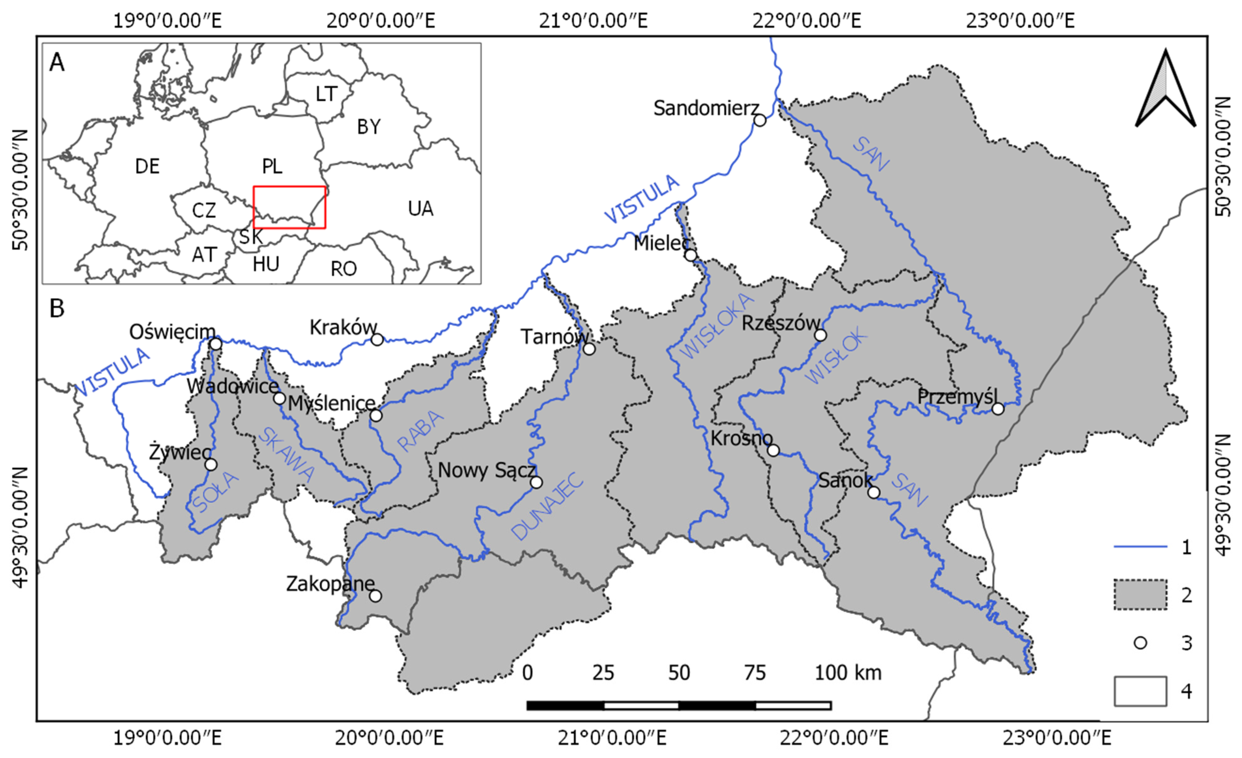
2. Research Area
3. Materials and Methods
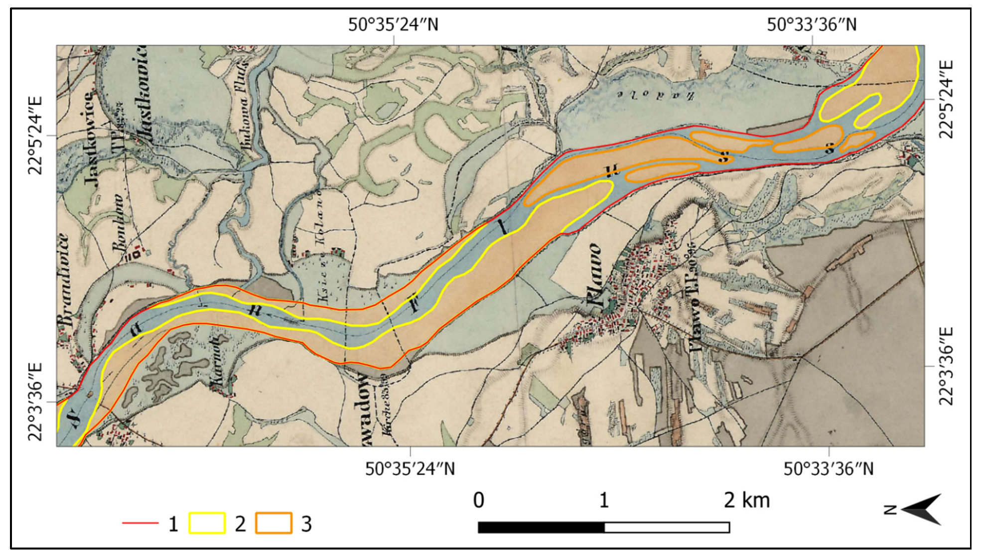
3.1. Cartographic Sources and GIS Data
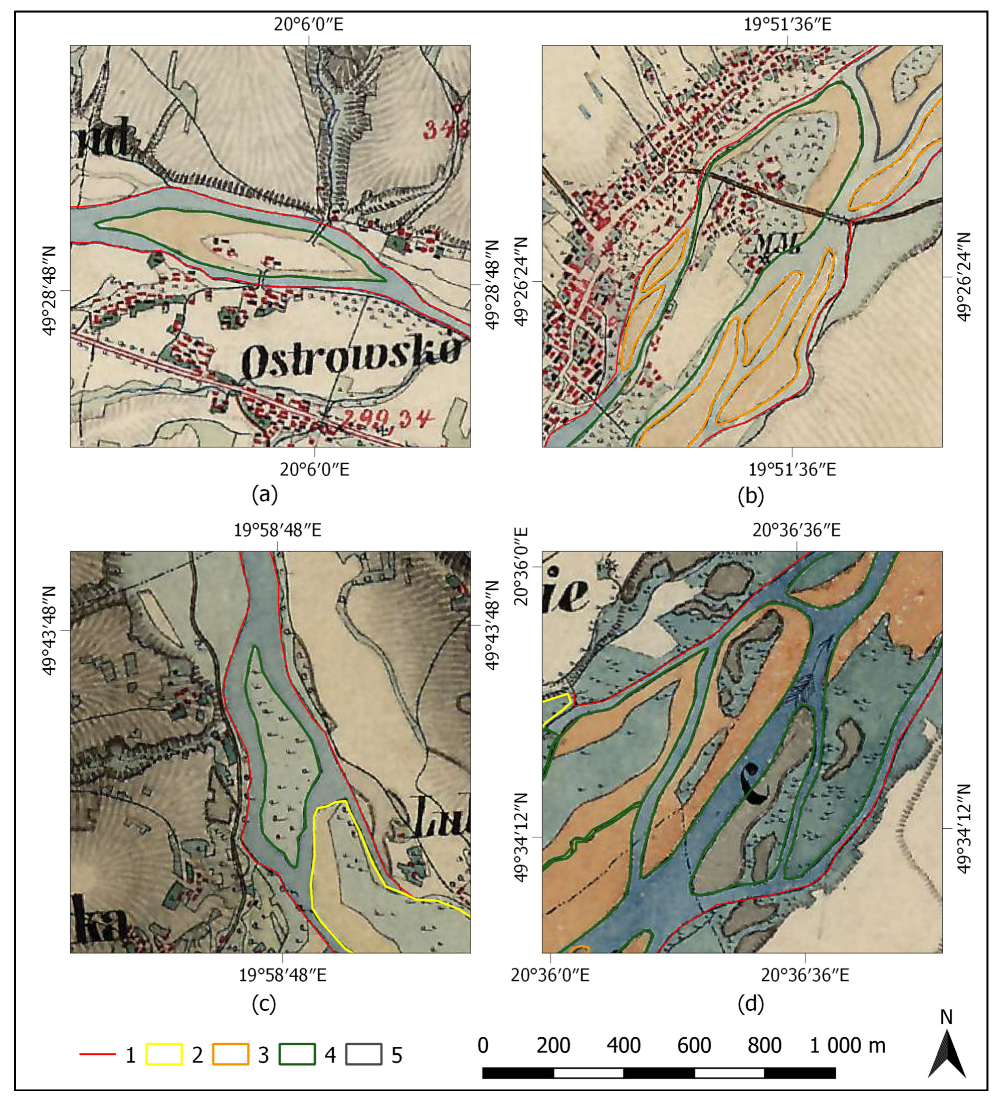
3.2. Typological Analysis of Channel Patterns
- Mid-channel bars: Bars not covered with vegetation
- Islands: Forms wholly or partially covered with vegetation, but not meeting the condition of Formula 1
- Inter-channel area: Forms covered in at least 50% by vegetation or buildings and meeting the condition of Formula (1)
4. Results
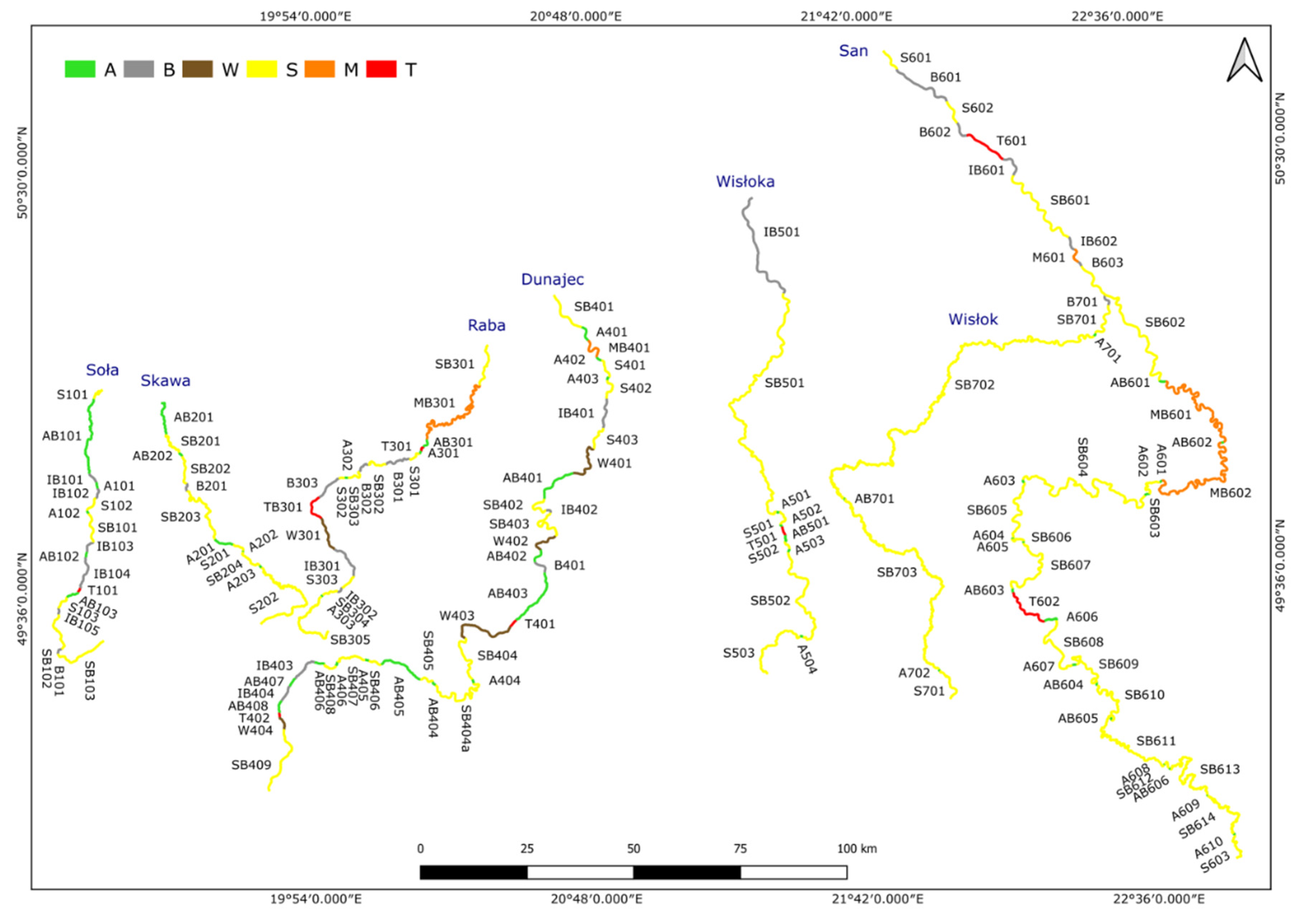
4.1. Historical Channel Patterns of Carpathian Rivers
4.1.1. The Mountain Courses of the Studied Rivers
4.1.2. The Intramontane Basins Courses of the Studied Rivers
4.1.3. The Foothill Courses of the Studied Rivers
4.1.4. The Subcarpathian Basins Courses of the Studied Rivers
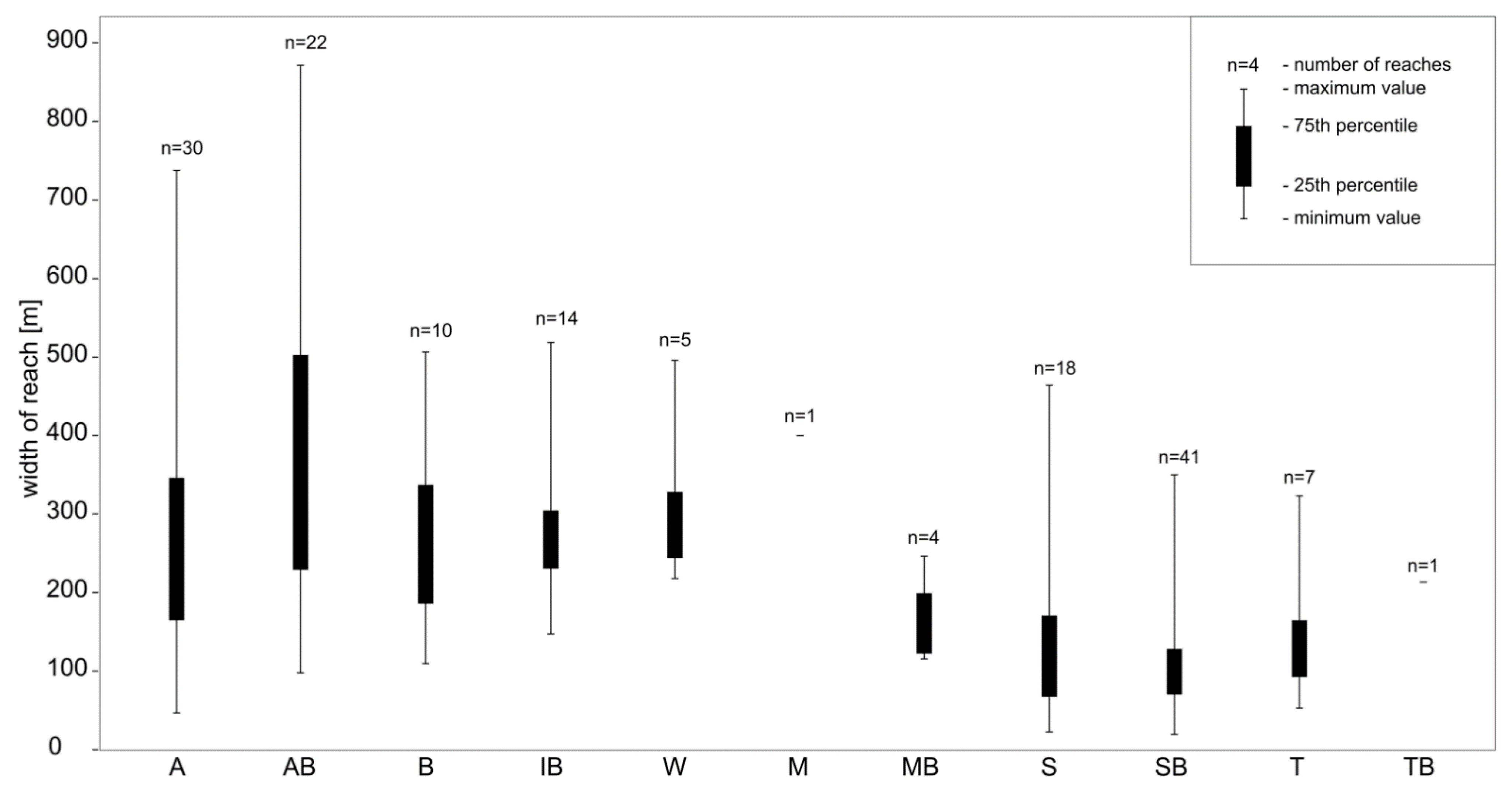
4.1.5. Common Features of Channel Pattern Types
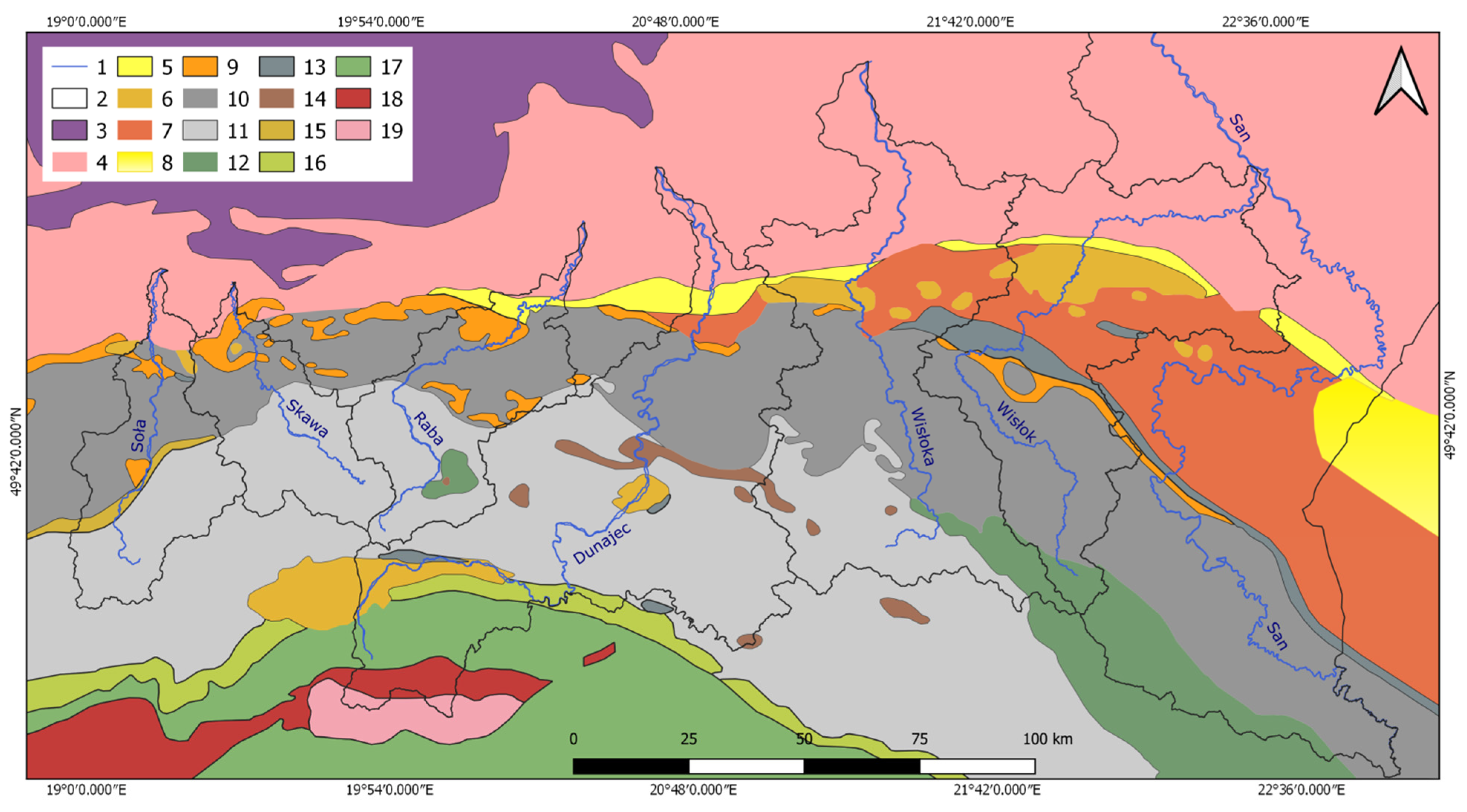
4.2. Orographic and Geological Conditions Controlling the Type of Channel Pattern
4.3. Other Factors Controlling Types of Channel Pattern
5. Discussion
6. Conclusions
- The nineteenth-century map of Galicia and Bucovina (1861–1864)—Second military survey of the Habsburg Empire enables the study of historical relief, including the identification of river channel functioning.
- Morphometric analysis has been verified as a tool to carry out an objective classification of channel patterns based on historical maps.
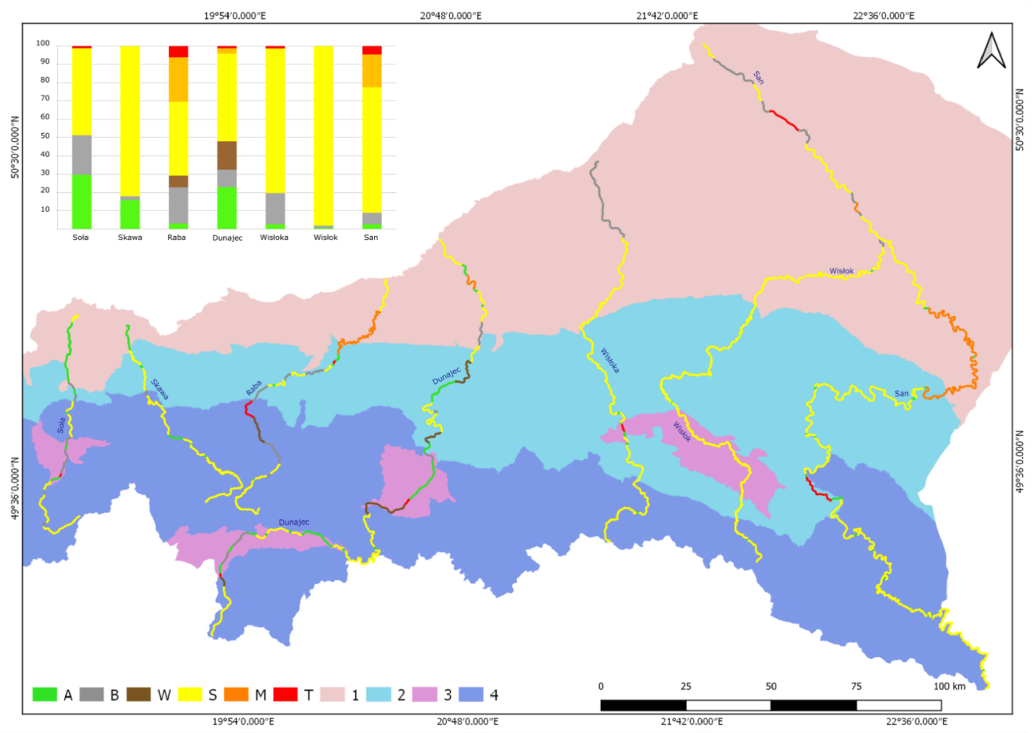
- In the rivers of the western part of the study area (Soła-Dunajec), multi-thread channels were dominant in the nineteenth century, especially anabranching systems with braided side channels. Single-thread channels dominated the rivers in the eastern part (Wisłoka-San).
- Higher relief energy, higher precipitation, more frequent floods, and a smaller proportion of forests in land cover favoured the activation of sediment and the formation of multi-thread reaches in the western part of the study area.
- The formation of individual reaches was determined by combinations of geological, orographic, and hydroclimatic factors creating specific local conditions. Most important for multi-thread reaches was the high supply or availability of gravel on the valley floor.
Funding
Institutional Review Board Statement
Informed Consent Statement
Data Availability Statement
Conflicts of Interest
Appendix A


| River | Reach | Mid-Channel Form | River | Reach | Mid-Channel Form | River | Reach | Mid-Channel Form | ||||||
|---|---|---|---|---|---|---|---|---|---|---|---|---|---|---|
| Bar | Island | Area | Bar | Island | Area | Bar | Island | Area | ||||||
| Soła | A101 | 2 | Dunajec | A401 | 2 | Wisłoka | A501 | 1 | ||||||
| A102 | 1 | A402 | 1 | A502 | 1 | |||||||||
| AB101 | 11 | 4 | 19 | A403 | 1 | A503 | 1 | |||||||
| AB102 | 3 | 3 | 2 | A404 | 1 | A504 | 1 | |||||||
| AB103 | 1 | 1 | 5 | A405 | 1 | AB501 | 1 | 2 | ||||||
| B101 | 4 | A406 | 1 | IB501 | 59 | 6 | ||||||||
| IB101 | 4 | 1 | AB401 | 4 | 7 | 9 | San | A601 | 1 | |||||
| IB102 | 1 | 3 | AB402 | 1 | 3 | A602 | 1 | |||||||
| IB103 | 6 | 1 | AB403 | 18 | 17 | 16 | A603 | 1 | ||||||
| IB104 | 27 | 2 | 1 | AB404 | 1 | 2 | A604 | 1 | ||||||
| IB105 | 4 | 1 | AB405 | 22 | 1 | 17 | A605 | 1 | ||||||
| Skawa | A201 | 5 | AB406 | 5 | 1 | 4 | A606 | 2 | ||||||
| A202 | 1 | AB407 | 6 | 1 | A607 | 1 | ||||||||
| A203 | 1 | AB408 | 2 | 7 | 2 | A608 | 1 | |||||||
| AB201 | 17 | 1 | 5 | B401 | 12 | A609 | 1 | |||||||
| AB202 | 2 | 1 | IB401 | 4 | 3 | A610 | 1 | |||||||
| B201 | 5 | IB402 | 3 | 1 | AB601 | 1 | 1 | |||||||
| Raba | A301 | 1 | IB403 | 11 | 3 | AB602 | 1 | 1 | 1 | |||||
| A302 | 1 | IB404 | 6 | 2 | AB603 | 1 | 1 | |||||||
| A303 | 1 | W401 | 12 | 2 | AB604 | 1 | 1 | |||||||
| AB301 | 1 | 1 | W402 | 9 | 1 | AB605 | 1 | 1 | ||||||
| B301 | 6 | W403 | 9 | 5 | 5 | AB606 | 1 | 1 | ||||||
| B302 | 6 | W404 | 4 | 1 | 3 | B601 | 12 | |||||||
| B303 | 7 | Wisłok | A701 | 1 | B602 | 7 | ||||||||
| IB301 | 10 | 11 | A702 | 1 | B603 | 3 | ||||||||
| IB302 | 8 | 1 | AB701 | 1 | 1 | IB601 | 6 | 1 | ||||||
| W301 | 4 | 2 | 7 | B701 | 5 | IB602 | 3 | 1 | ||||||
| River | River Course | Total | Length of Reaches (km) | Total | Number of Reaches | ||||||||||||||||||||
|---|---|---|---|---|---|---|---|---|---|---|---|---|---|---|---|---|---|---|---|---|---|---|---|---|---|
| A | AB | B | IB | W | S | SB | M | MB | T | TB | A | AB | B | IB | W | S | SB | M | MB | T | TB | ||||
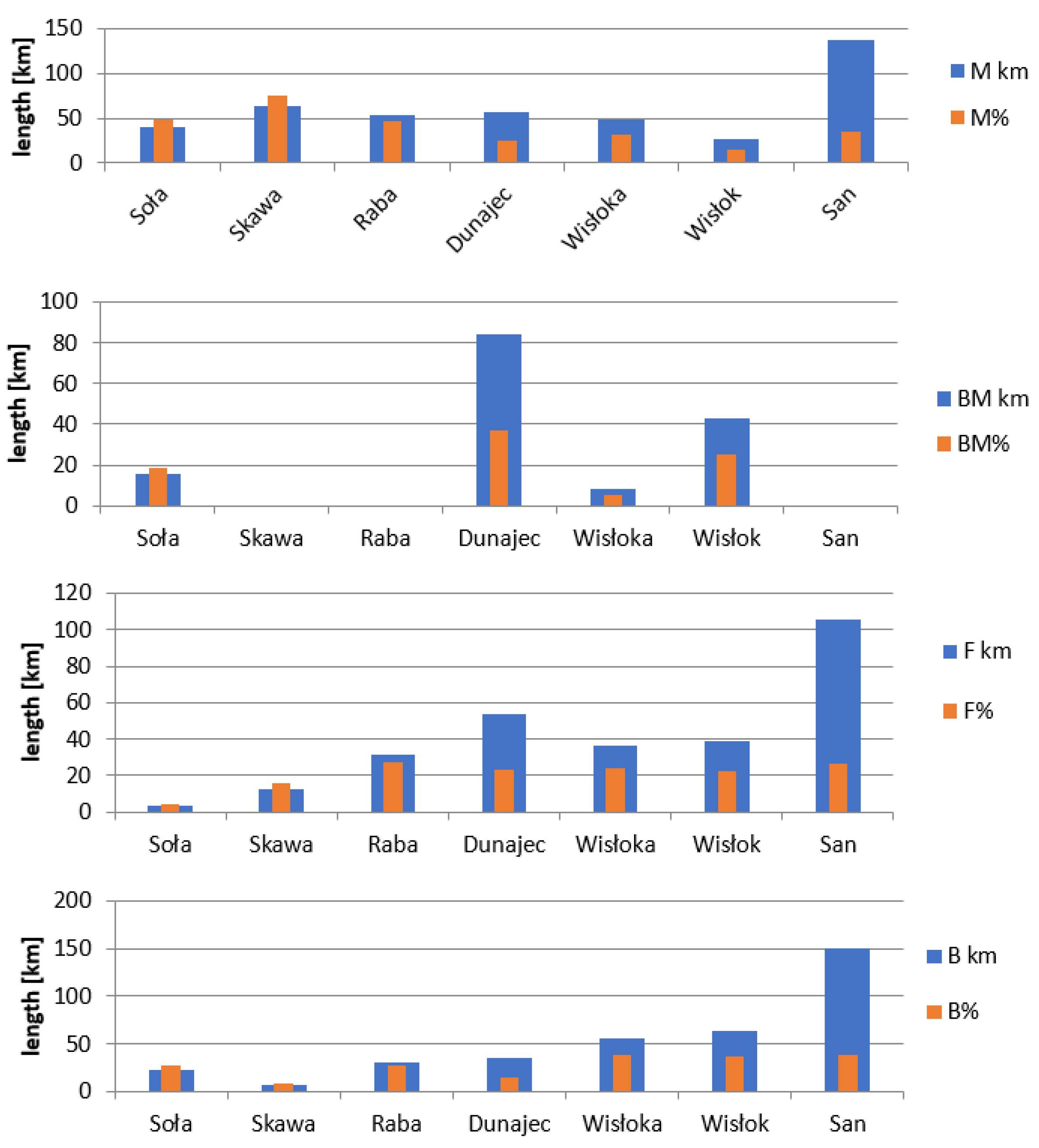
| Soła | whole | 92.3 | 2.2 | 25.1 | 1.7 | 18.3 | 11.9 | 32 | 1.1 | 18 | 2 | 3 | 1 | 5 | 3 * | 3 | 1 | ||||||||
| B | 27.4 | 20.6 | 2.7 | 4.1 | 3 | 1 | 1 | 1 | |||||||||||||||||
| F | 4.1 | 1.5 | 2.6 | 2 | 1 | 1 | |||||||||||||||||||
| M | 42.4 | 0.7 | 1.7 | 1.5 | 6.5 | 32 | 8 | 1 | 1 | 1 | 2 | 3 | |||||||||||||
| BM | 18.3 | 4.5 | 11.4 | 1.3 | 1.1 | 5 | 2 | 2 | 1 | 1 | |||||||||||||||
| Skawa | whole | 98.2 | 5.6 | 10 | 1.9 | 40.5 | 40.2 | 12 | 3 | 2 | 1 | 2 | 4 | ||||||||||||
| B | 8.8 | 8.8 | 1 | 1 | |||||||||||||||||||||
| F | 15.9 | 1.2 | 14.7 | 3 | 1 | 2 | |||||||||||||||||||
| M | 73.6 | 5.6 | 1.9 | 40.5 | 25.6 | 8 | 3 | 1 | 2 | 2 | |||||||||||||||
| BM | |||||||||||||||||||||||||
| Raba | whole | 137.5 | 1.9 | 2.4 | 16.4 | 10.7 | 8.6 | 9 | 46.5 | 33.5 | 1.2 | 7.3 | 21 | 3 | 1 | 3 | 2 | 1 | 3 | 5 | 1 * | 1 | 1 | ||
| B | 39 | 11 | 28 | 2 | 1 | 1 | |||||||||||||||||||
| F | 41.8 | 1.4 | 2.4 | 16.4 | 4.8 | 10.1 | 5.5 | 1.2 | 11 | 2 | 1 | 3 | 2 | 2 | 1 | 1 | |||||||||
| M | 56.7 | 0.4 | 10.7 | 8.6 | 4.2 | 25.5 | 7.3 | 8 | 1 | 2 | 1 | 1 | 2 | 1 | |||||||||||
| BM | |||||||||||||||||||||||||
| Dunajec | whole | 254.6 | 9.1 | 49.5 | 4 | 19.9 | 39.4 | 17.2 | 105.1 | 7.3 | 3.1 | 39 | 6 | 8 | 1 | 4 | 4 | 3 * | 10 | 1 | 2 | ||||
| B | 45.3 | 6.2 | 7.6 | 13.2 | 11 | 7.3 | 8 | 3 | 1 | 3 | 1 | 1 | |||||||||||||
| F | 59.3 | 14.3 | 1.5 | 19.1 | 4 | 20.4 | 8 | 2 | 1 | 2 | 1 | 2 | |||||||||||||
| M | 59.5 | 1 | 3.4 | 55.1 | 5 | 1 | 1 | 3 | |||||||||||||||||
| BM | 90.5 | 1.9 | 35.2 | 4 | 10.8 | 16.9 | 18.6 | 3.1 | 18 | 2 | 6 | 1 | 2 | 1 | 4 | 2 | |||||||||
| Wisłoka | whole | 170.6 | 2.8 | 1.7 | 29.1 | 27.3 | 107.5 | 2.2 | 12 | 4 | 1 | 1 | 3 * | 2 * | 1 | ||||||||||
| B | 68.5 | 29.1 | 39.4 | 2 | 1 | 1 | |||||||||||||||||||
| F | 39.4 | 0.7 | 2.4 | 36.3 | 2 | 1 | 1 | 1 | |||||||||||||||||
| M | 53.3 | 0.7 | 20.8 | 31.8 | 3 | 1 | 1 | 1 | |||||||||||||||||
| BM | 9.5 | 1.4 | 1.7 | 4.2 | 2.2 | 5 | 2 | 1 | 2 | 1 | |||||||||||||||
| San | whole | 495 | 8.2 | 4.8 | 21.1 | 9.8 | 20.9 | 319 | 4.1 | 84.3 | 22.8 | 43 | 10 | 6 | 3 | 2 | 3 | 14 * | 1 | 2 * | 2 | ||||
| B | 201 | 2 | 21.1 | 9.8 | 11.7 | 68.9 | 4.1 | 72.7 | 10.7 | 15 | 2 | 3 | 2 | 2 | 2 | 1 | 2 | 1 | |||||||
| F | 146.6 | 6.7 | 0.9 | 115.3 | 11.6 | 12.1 | 13 | 6 | 1 | 6 | 1 | 1 | |||||||||||||
| M | 147.4 | 1.6 | 1.8 | 9.3 | 134.7 | 15 | 4 | 3 | 1 | 7 | |||||||||||||||
| BM | |||||||||||||||||||||||||
| Wisłok | whole | 229.3 | 1.1 | 0.3 | 3 | 10.4 | 214.5 | 8 | 2 | 1 | 1 | 1 | 3 * | ||||||||||||
| B | 66.6 | 0.8 | 3 | 62.8 | 4 | 1 | 1 | 2 | |||||||||||||||||
| F | 79 | 0.3 | 78.7 | 1 | 1 | 2 | |||||||||||||||||||
| M | 29.1 | 0.4 | 10.4 | 18.3 | 2 | 1 | 1 | 1 | |||||||||||||||||
| BM | 54.7 | 54.7 | 1 | 1 | |||||||||||||||||||||
| Preceding Reaches | Following Reaches | |||||||||||||||||||||||
|---|---|---|---|---|---|---|---|---|---|---|---|---|---|---|---|---|---|---|---|---|---|---|---|---|
| Lack (Source) | A | AB | B | IB | W | S | SB | M | MB | T | TB | A | AB | B | IB | W | S | SB | M | MB | T | TB | Lack (Mouth) | |
| 3.3 | 36.7 | 53.4 | 3.3 | 3.3 | A | 3.3 | 16.7 | 66.6 | 6.7 | 6.7 | ||||||||||||||
| 4.5 | 18.2 | 9.1 | 40.9 | 9.1 | 18.2 | AB | 4.5 | 13.6 | 9.1 | 9.1 | 41 | 9.1 | 9.1 | 4.5 | ||||||||||
| 10 | 10 | 60 | 10 | 10 | B | 10 | 40 | 30 | 10 | 10 | ||||||||||||||
| 7.1 | 21.5 | 21.5 | 35.7 | 7.1 | 7.1 | IB | 7.1 | 28.6 | 7.1 | 21.5 | 21.5 | 7.1 | 7.1 | |||||||||||
| 40 | 20 | 40 | W | 20 | 20 | 40 | 20 | |||||||||||||||||
| 21.1 | 26.3 | 10.5 | 21.1 | 15.7 | 5.3 | S | 57.9 | 10.5 | 5.3 | 15.8 | 10.5 | |||||||||||||
| 7.5 | 50 | 22.5 | 7.5 | 7.5 | 2.5 | 2.5 | SB | 40 | 22.5 | 15 | 12.5 | 5 | 5 | |||||||||||
| 100 | M | 100 | ||||||||||||||||||||||
| 50 | 50 | MB | 25 | 50 | 25 | |||||||||||||||||||
| 28.6 | 28.6 | 14.2 | 28.6 | T | 14.3 | 57.1 | 14.3 | 14.3 | ||||||||||||||||
| 100 | TB | 100 | ||||||||||||||||||||||

References
- Buffington, J.M.; Montgomery, D.R. Geomorphic classification of rivers. In Treatise on Geomorphology; Fluvial Geomorphology; Shroder, J., Wohl, E., Eds.; Academic Press: San Diego, CA, USA, 2013; Volume 9, pp. 730–767. [Google Scholar]
- Schumm, S.A. The Fluvial System; John Wiley and Sons: New York, NY, USA, 1977. [Google Scholar]
- Montgomery, D.R. Process domains and the river continuum. JAWRA J. Am. Water Resour. Assoc. 1999, 35, 397–410. [Google Scholar] [CrossRef]
- Brierley, G.J.; Fryirs, K.A. Geomorphology and River Management: Applications of the River Styles Framework; Blackwell: Oxford, UK, 2005. [Google Scholar]
- Church, M. Bed material transport and the morphology of alluvial river channels. Annu. Rev. Earth Planet. Sci. 2006, 34, 325–354. [Google Scholar] [CrossRef]
- Meshkova, L.V.; Carling, P.A. Discrimination of alluvial and mixed bedrock-alluvial multichannel river networks. Earth Surf. Process. Landf. 2013, 38, 1299–1316. [Google Scholar] [CrossRef]
- Rinaldi, M.; Gurnell, A.M.; del Tánago, M.G.; Bussettini, M.; Hendriks, D. Classification of river morphology and hydrology to support management and restoration. Aquat. Sci. 2016, 78, 17–33. [Google Scholar] [CrossRef]
- Nardini, A.; Brierley, G. Automatic river planform identification by a logical-heuristic algorithm. Geomorphology 2021, 375, 107558. [Google Scholar] [CrossRef]
- Mandarino, A.; Pepe, G.; Cevasco, A.; Brandolini, P. Quantitative Assessment of Riverbed Planform Adjustments, Channelization, and Associated Land Use/Land Cover Changes: The Ingauna Alluvial-Coastal Plain Case (Liguria, Italy). Remote Sens. 2021, 13, 3775. [Google Scholar] [CrossRef]
- Hohensinner, S.; Egger, G.; Muhar, S.; Vaudor, L.; Piégay, H. What remains today of pre-industrial Alpine rivers? Census of historical and current channel patterns in the Alps. River Res. Appl. 2021, 37, 128–149. [Google Scholar] [CrossRef]
- Škarpich, V.; Hradecký, J.; Dušek, R. Complex transformation of the geomorphic regime of channels in the forefield of the Moravskoslezské Beskydy Mts.: Case study of the Morávka River (Czech Republic). Catena 2013, 111, 25–40. [Google Scholar] [CrossRef]
- Witkowski, K. Man’s impact on the transformation of channel patterns (the Skawa River, southern Poland). River Res. Appl. 2021, 37, 150–162. [Google Scholar] [CrossRef]
- Scorpio, V.; Rosskopf, C.M. Channel adjustments in a Mediterranean river over the last 150years in the context of anthropic and natural controls. Geomorphology 2016, 275, 90–104. [Google Scholar] [CrossRef]
- Bertrand, M.; Piégay, H.; Pont, D.; Liébault, F.; Sauquet, E. Sensitivity analysis of environmental changes associated with riverscape evolutions following sediment reintroduction: Geomatic approach on the Drôme River network, France. Int. J. River Basin Manag. 2013, 11, 19–32. [Google Scholar] [CrossRef]
- Arnaud, F.; Schmitt, L.; Johnstone, K.; Rollet, A.-J.; Piégay, H. Engineering impacts on the Upper Rhine channel and floodplain over two centuries. Geomorphology 2019, 330, 13–27. [Google Scholar] [CrossRef]
- Konias, A. Kartografia Topograficzna Śląska Cieszyńskiego i Zaboru Austriackiego od II Połowy XVIII Wieku do Początku XX Wieku; Wyd. Uniwersytetu Śląskiego: Katowice, Poland, 2000. [Google Scholar]
- Habersack, H.; Piégay, H. River restoration in the Alps and their surroundings: Past experience and future challenges. Dev. Earth Surf. Process. 2007, 11, 703–735. [Google Scholar] [CrossRef]
- Scorpio, V.; Zen, S.; Bertoldi, W.; Surian, N.; Mastronunzio, M.; Dai Prá, E.; Zolezzi, G.; Comiti, F. Channelization of a large Alpine river: What is left of its original morphodynamics? Earth Surf. Process. Landf. 2018, 43, 1044–1062. [Google Scholar] [CrossRef]
- Škarpich, V.; Horáček, M.; Galia, T.; Kapustová, V.; Šala, V. The effects of river patterns on riparian vegetation: A comparison of anabranching and single-thread incised channels. Morav. Geogr. Rep. 2016, 24, 24–31. [Google Scholar] [CrossRef] [Green Version]
- Magny, M.; Arnaud, F.; Holzhauser, H.; Chapron, E.; Debret, M.; Desmet, M.; Leroux, A.; Millet, L.; Revel, M.; Vannière, B. Solar and proxy-sensitivity imprints on paleohydrological records for the last millennium in west-central Europe. Quat. Res. 2010, 73, 173–179. [Google Scholar] [CrossRef] [Green Version]
- Kondolf, G.M.; Piegay, H.; Landon, N. Changes in the riparian zone of the lower Eygues River, France, since 1830. Landsc. Ecol. 2007, 22, 367–384. [Google Scholar] [CrossRef]
- Zieliński, T. Sedymentologia. Osady Rzek i Jezior; Wyd. Nauk. Uniwersytetu im. Adama Mickiewicza w Poznaniu: Poznań, Poland, 2015. [Google Scholar]
- Ortyl, B.; Ćwik, A.; Kasprzyk, I. What happens in a Carpathian catchment after the sudden abandonment of cultivation? Catena 2018, 166, 158–170. [Google Scholar] [CrossRef]
- Werritty, A.; Leys, K.F. The sensitivity of Scottish rivers and upland valley floors to recent environmental change. CATENA 2001, 42, 251–273. [Google Scholar] [CrossRef]
- Schumm, S.A. River Metamorphosis. J. Hydraul. Div. 1969, 95, 255–274. [Google Scholar] [CrossRef]
- Woskowicz-Ślęzak, B.; Ślęzak, A. Zapis antropopresji w rzeźbie przedgórskiego odcinka dna doliny Soły. In Antropopresja w Wybranych Strefach Morfoklimatycznych—Zapis Zmian w Rzeźbie i Osadach; Łajczak, A., Ed.; Uniwersytet Śląski: Sosnowiec, Poland, 2012; pp. 441–452. [Google Scholar]
- Wyżga, B. Funkcjonowanie systemu rzecznego środkowej i dolnej Raby w ostatnich 200 latach. Dok. Geogr. 1993, 6, 1–94. [Google Scholar]
- Liro, M. Development of sediment slug upstream from the Czorsztyn Reservoir (southern Poland) and its interaction with river morphology. Geomorphology 2016, 253, 225–238. [Google Scholar] [CrossRef]
- Hajdukiewicz, M.; Wyżga, B.; Hajdukiewicz, H.; Mikuś, P. Photogrammetric reconstruction of changes in vertical river position using archival aerial photos: Case study of the Czarny Dunajec River, Polish Carpathians. Acta Geophys. 2019, 67, 1205–1221. [Google Scholar] [CrossRef] [Green Version]
- Klimek, K. Man’s Impact on Fluvial Processes in the Polish Western Carpathians. Geogr. Ann. Ser. A Phys. Geogr. 1987, 69, 221–226. [Google Scholar] [CrossRef]
- Hajdukiewicz, H.; Wyżga, B.; Zawiejska, J. Twentieth-century hydromorphological degradation of Polish Carpathian rivers. Quat. Int. 2019, 504, 181–194. [Google Scholar] [CrossRef]
- Wyżga, B.; Zawiejska, J.; Hajdukiewicz, H. Multi-thread rivers in the Polish Carpathians: Occurrence, decline and possibilities of restoration. Quat. Int. 2016, 415, 344–356. [Google Scholar] [CrossRef]
- Baumgart-Kotarba, M. Braided channel changes at chosen reaches of the Bialka river (the Podhale, Western Carpathians). Stud. Geomorphol. Carpatho-Balc. 1980, 14, 113–134. [Google Scholar]
- Witkowski, K. The Galician Canal—An unrealized project that changed the rivers in the northern part of the Carpathians. River Res. Appl. 2021, 37( 9), 1343–1356. [Google Scholar] [CrossRef]
- Storetvedt, K.M. The Tethys Sea and the Alpine-Himalayan orogenic belt; mega-elements in a new global tectonic system. Phys. Earth Planet. Inter. 1990, 62, 141–184. [Google Scholar] [CrossRef]
- Solon, J.; Borzyszkowski, J.; Bidłasik, M.; Richling, A.; Badora, K.; Balon, J.; Brzezińska-Wójcik, T.; Chabudziński, Ł.; Dobrowolski, R.; Grzegorczyk, I.; et al. Physico-geographical mesoregions of Poland—Verification and adjustment of boundaries on the basis of contemporary spatial data. Geogr. Pol. 2018, 91, 143–170. [Google Scholar] [CrossRef]
- Chlebowski, B.; Walewski, W. Słownik Geograficzny Królestwa Polskiego i Innych Krajów Słowiańskich. Tom X; Kasa im. Józefa Mianowskiego: Warszawa, Poland, 1889. [Google Scholar]
- Cebulska, M.; Twardosz, R. Zmienność czasowa najwyższych miesięcznych sum opadów atmosferycznych w Polskich Karpatach Zachodnich (1951–2005). Pr. Geogr. 2012, 128, 123–134. [Google Scholar] [CrossRef]
- Ziemońska, Z. Stosunki wodne w polskich Karpatach Zachodnich. Pr. Geogr. 1973, 103, 1–127. [Google Scholar]
- Soja, R. Hydrologiczne Aspekty Antropopresji w Polskich Karpatach; IGiPZ PAN: Warszawa, Poland, 2002. [Google Scholar]
- Timár, G.; Molnár, G.; Székely, B.; Biszak, S.; Varga, J.; Jankó, A. The Map Sheets of the Second Military Survey and Their Georeferenced Version; Arcanum: Budapest, Hungary, 2006; ISBN 963-7374-33-7. [Google Scholar]
- Vichrova, M. Digital terrain model of the Second Military Survey. Two model territories: The surroundings of the town Rokycany and part of the military training area Brdy. E-Perimetron 2012, 7, 124–135. [Google Scholar] [CrossRef] [Green Version]
- Kondracki, J. Geografia Polski. Mezoregiony Fizycznogeograficzne; Wyd. Nauk. PWN: Warszawa, Poland, 1994; ISBN 8301114223. [Google Scholar]
- Oszczypko, N.; Ślączka, A.; Żytko, K. Regionalizacja tektoniczna Polski—Karpaty zewnętrzne i zapadlisko przedkarpackie. Przegląd Geol. 2008, 56, 927–935. [Google Scholar]
- Polish Geological Institute Detailed Geological Map of Poland, 1:50,000. Available online: https://geologia.pgi.gov.pl/ (accessed on 10 October 2021).
- Head Office of Geodesy and Cartography Map of Relief Shading, WMTS. Available online: https://mapy.geoportal.gov.pl/ (accessed on 25 October 2021).
- National Water Management Board National Water and Environmental Programme. Available online: https://apgw.gov.pl/pl/II-cykl-materialy-do-pobrania (accessed on 5 September 2021).
- European Environment Agency European River Catchments. Available online: https://www.eea.europa.eu/data-and-maps/data/european-river-catchments-1 (accessed on 5 September 2021).
- Brice, J.C.; Blodgett, J.C. Counter Measures for Hydraulic Problems at Bridges. 1. Analysis and Assessment, Report No. FHWA-RD-78-162.; Federal Highway Administration: Washington, DC, USA, 1978. [Google Scholar]
- Teisseyre, A.K. Klasyfikacja Rzek w świetle Analizy Systemu Fluwialnego i Geometrii Hydraulicznej; Wyd. Uniwersytetu Wrocławskiego: Wrocław, Poland, 1991. [Google Scholar]
- Chełmicki, W.; Skąpski, R.; Soja, R. Reżim hydrologiczny rzek karpackich w Polsce. Folia Geogr. Ser. Geogr. 1999, 29–30, 67–80. [Google Scholar]
- Dynowska, I. Typy reżimów rzecznych w Polsce. Zesz. Nauk. UJ Pr. Geogr. 1971, 268, 1–147. [Google Scholar]
- Wrzesiński, D.; Marsz, A.A.; Styszyńska, A.; Sobkowiak, L. Effect of the North Atlantic Thermohaline Circulation on changes in climatic conditions and river flow in Poland. Water 2019, 11, 1622. [Google Scholar] [CrossRef] [Green Version]
- Fal, B. Zmienność odpływu z obszaru Polski w bieżącym stuleciu. Wiad. IMGW 1993, 16, 3–20. [Google Scholar]
- Wrzesiński, D.; Sobkowiak, L. Detection of changes in flow regime of rivers in Poland. J. Hydrol. Hydromech. 2018, 66, 55–64. [Google Scholar] [CrossRef] [Green Version]
- Broda, J. Proces wylesienia na ziemiach polskich od czasów najdawniejszych. Czas. Geogr. 1985, 56, 151–173. [Google Scholar]
- Kozak, J.; Ziółkowska, E.; Vogt, P.; Dobosz, M.; Kaim, D.; Kolecka, N.; Ostafin, K. Forest-Cover Increase Does Not Trigger Forest-Fragmentation Decrease: Case Study from the Polish Carpathians. Sustainability 2018, 10, 1472. [Google Scholar] [CrossRef] [Green Version]
- Kaim, D.; Kozak, J.; Kolecka, N.; Ziółkowska, E.; Ostafin, K.; Ostapowicz, K.; Gimmi, U.; Munteanu, C.; Radeloff, V.C. Broad scale forest cover reconstruction from historical topographic maps. Appl. Geogr. 2016, 67, 39–48. [Google Scholar] [CrossRef]
- Bravard, J.-P.; Bethemont, J. Cartography of rivers in France. In Historical change of large alluvial rivers, Western Europe; Petts, G.E., Moller, H., Roux, A.L., Eds.; John Wiley & Sons: Chichester, UK, 1989; pp. 95–111. [Google Scholar]
- Hohensinner, S.; Jungwirth, M.; Muhar, S.; Schmutz, S. Spatio-temporal habitat dynamics in a changing Danube River landscape 1812–2006. River Res. Appl. 2011, 27, 939–955. [Google Scholar] [CrossRef]
- Carling, P.; Jansen, J.; Meshkova, L. Multichannel rivers: Their definition and classification. Earth Surf. Process. Landf. 2014, 39, 26–37. [Google Scholar] [CrossRef]
- Nanson, G.C.; Knighton, D.A. Anabranching rivers: Their cause, character and classification. Earth Surf. Process. Landf. 1996, 21, 217–239. [Google Scholar] [CrossRef]
- Rosgen, D.L. A Classification of Natural Rivers. Catena 1994, 22, 169–199. [Google Scholar] [CrossRef] [Green Version]
- Kleinhans, M.G. Sorting out river channel patterns. Prog. Phys. Geogr. 2010, 34, 287–326. [Google Scholar] [CrossRef]
- Schumm, S.A. Patterns of alluvial rivers. Annu. Rev. Earth Planet. Sci. 1985, 13, 5–27. [Google Scholar] [CrossRef]
- Henriques, M.; McVicar, T.R.; Holland, K.L.; Daly, E. Riparian vegetation and geomorphological interactions in anabranching rivers: A global review. Ecohydrology 2021, e2370. [Google Scholar] [CrossRef]
- Smith, D.G. Effect of vegetation on lateral migration of anastomosed channels of a glacial meltwater river. Geol. Soc. Am. Bull. 1976, 86, 857–860. [Google Scholar] [CrossRef]
- Rzepecka, A.; Czajka, B.; Mikuś, P.; Kaczka, R.; Wyżga, B. Rozwój kępy o złożonej strukturze w żwirodennej rzece górskiej. Wyniki analiz dendrochronologicznych i kartograficznych. Stud. Mater. CEPL Rogowie 2012, 14, 105–110. [Google Scholar]
- Winterbottom, S.J. Medium and short-term channel planform changes on the Rivers Tay and Tummel, Scotland. Geomorphology 2000, 34, 195–208. [Google Scholar] [CrossRef]
- Szmańda, J.; Luc, M. Układ wielokorytowy Dunaju pomiędzy Ćunovem a Gabćikovem—Analiza przestrzenna na podstawie klasyfikacji rzek według Brice’a. Landf. Anal. 2010, 13, 129–133. [Google Scholar]
- Ward, J.V.; Stanford, J.A. The serial discontinuity concept: Extending the model to floodplain rivers. Regul. Rivers Res. Manag. 1995, 10, 159–168. [Google Scholar] [CrossRef]
- Church, M. Channel morphology and typology. In The Rivers Handbook; Calow, P., Petts, G.E., Eds.; Blackwell: Oxford, UK, 1992; pp. 126–143. [Google Scholar]
- Notebaert, B.; Piégay, H. Multi-scale factors controlling the pattern of floodplain width at a network scale: The case of the Rhône basin, France. Geomorphology 2013, 200, 155–171. [Google Scholar] [CrossRef]
- Poole, G.C. Fluvial landscape ecology: Addressing uniqueness within the river discontinuum. Freshw. Biol. 2002, 47, 641–660. [Google Scholar] [CrossRef] [Green Version]
- Gorczyca, E. Myrphodynamics of the River Łososina channel after an Extreme Flood (Western Carpathian Mountains). Geografija 2007, 43, 70–77. [Google Scholar]
- Korpak, J. The influence of river training on mountain channel changes (Polish Carpathian Mountains). Geomorphology 2007, 92, 166–181. [Google Scholar] [CrossRef]
- Mueller, E.R.; Pitlick, J. Sediment supply and channel morphology in mountain river systems: 2. Single thread to braided transitions. J. Geophys. Res. Earth Surf. 2014, 119, 1516–1541. [Google Scholar] [CrossRef]
- Mueller, E.R.; Pitlick, J. Sediment supply and channel morphology in mountain river systems: 1. Relative importance of lithology, topography, and climate. J. Geophys. Res. Earth Surf. 2013, 118, 2325–2342. [Google Scholar] [CrossRef]
- Ward, J.V.; Tockner, K.; Edwards, P.J.; Kollmann, J.; Bretschko, G.; Gurnell, A.M.; Petts, G.E.; Rossaro, B. A reference river system for the Alps: The ‘Fiume Tagliamento’. Regul. Rivers Res. Manag. 1999, 15, 63–75. [Google Scholar] [CrossRef] [Green Version]
- Zasadni, J.; Kłapyta, P. The Tatra Mountains during the Last Glacial Maximum. J. Maps 2014, 10, 440–456. [Google Scholar] [CrossRef] [Green Version]
- Kłapyta, P. Geomorphology of the high-elevated flysch range—Mt. Babia Góra Massif (Western Carpathians). J. Maps 2020, 16, 689–701. [Google Scholar] [CrossRef]
- Smith, N.D.; McCarthy, T.S.; Ellery, W.N.; Merry, C.L.; Rüther, H. Avulsion and anastomosis in the panhandle region of the Okavango Fan, Botswana. Geomorphology 1997, 20, 49–65. [Google Scholar] [CrossRef]
- Schumm, S.A.; Khan, H.R. Experimental Study of Channel Patterns. GSA Bull. 1972, 83, 1755–1770. [Google Scholar] [CrossRef]
- Leopold, L.B.; Wolman, M.G. River channel patterns—Braided, meandering and straight. US Geol. Surv. Prof. Pap. 1957, 282, 39–85. [Google Scholar]
- Makaske, B. Anastomosing rivers. Forms, processes and sediments. Ned. Geogr. Stud. 1998, 249, 1–285. [Google Scholar]
- Doeglas, D.J. Meandering and braided rivers. Geol. Mijnb. 1951, 13, 297–299. [Google Scholar]
- Germanoski, D.; Schumm, S.A. Changes in Braided River Morphology Resulting from Aggradation and Degradation. J. Geol. 1993, 101, 451–466. [Google Scholar] [CrossRef]
- Škarpich, V.; Hradecký, J.; Tábořík, P. Structure and genesis of the quaternary filling of the Slavíč River valley (Moravskoslezské Beskydy Mts., Czech Republic). Morav. Geogr. Rep. 2011, 19, 30–38. [Google Scholar]
- Wojkowski, J.; Wałęga, A.; Radecki-Pawlik, A.; Młyński, D.; Lepeška, T. The influence of land cover changes on landscape hydric potential and river flows: Upper Vistula, Western Carpathians. CATENA 2021, 105878. [Google Scholar] [CrossRef]
- Stacke, V.; Panek, T.; Sedlacek, J. Late Holocene evolution of the Bečva River floodplain (Outer Western Carpathians, Czech Republic) as a record of interaction between erosion-prone catchment and environmental change. Geomorphology 2014, 206, 440–451. [Google Scholar] [CrossRef]
- Lach, J.; Wyżga, B. Channel incision and flow increase of the upper Wisłoka River, southern Poland, subsequent to the reforestation of its catchment. Earth Surf. Process. Landf. 2002, 27, 445–462. [Google Scholar] [CrossRef]
- Perşoiu, I.; Rǎdoane, M. Spatial and temporal controls on historical channel responses—Study of an atypical case: Someşu Mic River, Romania. Earth Surf. Process. Landf. 2011, 36, 1391–1409. [Google Scholar] [CrossRef]
- Vandenberghe, J.; Woo, M. Modern and ancient periglacial river types. Prog. Phys. Geogr. Earth Environ. 2002, 26, 479–506. [Google Scholar] [CrossRef]
- Kukulak, J. Impact of mediaeval agriculture on the alluvium in the San River headwaters (Polish Eastern Carpathians). CATENA 2003, 51, 255–266. [Google Scholar] [CrossRef]
- Henkiel, A. Geomorphological microregions of the Polish Bieszczady Mountains. Ann. UMCS Sec. B 1997, 52, 133–145. [Google Scholar]
- Scorpio, V.; Surian, N.; Cucato, M.; Dai Prá, E.; Zolezzi, G.; Comiti, F. Channel changes of the Adige River (Eastern Italian Alps) over the last 1000 years and identification of the historical fluvial corridor. J. Maps 2018, 14, 680–691. [Google Scholar] [CrossRef]
- Bravard, J.-P. Discontinuities in braided patterns: The River Rhône from Geneva to the Camargue delta before river training. Geomorphology 2010, 117, 219–233. [Google Scholar] [CrossRef]
- Van der Berg, J.H. Prediction of alluvial channel pattern of perennial rivers. Geomorphology 1995, 12, 259–279. [Google Scholar] [CrossRef]
- Colombini, M.; Seminaria, G.; Tubino, M. Finite-amplitude alternate bars. J. Fluid Mech. 1987, 181, 213–232. [Google Scholar] [CrossRef]
- Witkowski, K.; Witkowski, M. The impact of watermills on changes in the hydrographic network in the Carpathian Foothills in Poland. Carpathian J. Earth Environ. Sci. 2018, 13, 605–611. [Google Scholar] [CrossRef]
- Kalicki, T.; Przepióra, P.; Kusztal, P.; Chrabąszcz, M.; Fularczyk, K.; Kłusakiewicz, E.; Frączek, M. Historical and present-day human impact on fluvial systems in the Old-Polish Industrial District (Poland). Geomorphology 2020, 357, 107062. [Google Scholar] [CrossRef]
- Gorczyca, E.; Krzemień, K.; Jarzyna, K. The Evolution of Gravel-Bed Rivers during the Post-Regulation Period in the Polish Carpathians. Water 2020, 12, 254. [Google Scholar] [CrossRef] [Green Version]
- Zawiejska, J.; Wyżga, B. Twentieth-century Channel Change on the Dunajec River, Southern Poland: Patterns, Causes and Controls. Geomorphology 2010, 117, 234–246. [Google Scholar] [CrossRef]
- Klimek, K.; Trafas, K. Young-Holocene changes in the course of the Dunajec River in the Beskid Sadecki Mts (Western Carpathians). Stud. Geomorphol. Carpatho-Balc. 1972, 6, 85–92. [Google Scholar]
- Zuchiewicz, W.; Tokarski, A.K.; Świerczewska, A.; Cuong, N.Q. Neotectonic activity of the Skawa River Fault Zone (Outer Carpathians, Poland). Ann. Soc. Geol. Pol. 2009, 79, 67–93. [Google Scholar]
- Gorczyca, E. Rozwój Górskich Żwirodennych Koryt Rzecznych w Warunkach Antropopresji; Instytut Geografii i Gospodarki Przestrzennej UJ: Kraków, Poland, 2016; ISBN 9788364089251. [Google Scholar]
- Sobucki, M.; Gorczyca, E.; Giriat, D. Human induced channel changes of the upper Wisłoka River during last 150 years (Polish Carpathian Mts.). In Proceedings of the FLAG Scientific Programme, Remich, Luxemburg, 2–7 September 2012; p. 28. [Google Scholar]


| River | Length in the 19th c. (km) | Length of River Valley | Catchment Area (km2) | Mouth Elevation (m asl) | Source Elevation (m asl) | Source Reach Name, if Different from the River Name |
|---|---|---|---|---|---|---|
| Soła | 92.3 | 82 | 1390 | 229 | 999 | Bystra ->Ujsoła |
| Skawa | 98.2 | 83.4 | 1166 | 220 | 690 | |
| Raba | 137.5 | 115.9 | 1534 | 180 | 755 | |
| Dunajec | 254.6 | 229.3 | 6767 | 174 | 1500 | Wyżni Chochołowski -> Chochołowski -> Czarny Dunajec |
| Wisłoka | 170.6 | 148.5 | 3888 | 156 | 575 | |
| San | 495 | 393.8 | 16,756 | 138 | 920 | |
| Wisłok | 229.3 | 172.8 | 3542 | 168 | 770 |
| Basic Classification | Additions to the Classification | Designation in the Study | Mid-Channel Forms | BI | AI | SI | |||
|---|---|---|---|---|---|---|---|---|---|
| Rinaldi et al. [7] | Brice & Blodgett [49] | Teisseyre [50] | |||||||
| Channel types | multi-thread | anabranching (high energy) | anabranching with channels of low sinuosity | adaptation of the length and width of the inter-channel areas to gravel-bed rivers | A | inter-channel areas | 1 | >1.5 | - |
| anabranching with complex channels | AB | inter-channel areas, islands, mid-channel bars | >1 | >1.5 | |||||
| braiding | B | mid-channel bars | >1.5 | 1 | - | ||||
| braiding with islands | IB | islands, mid-channel bars | >1.5 | >1 | |||||
| wandering | W | islands, mid-channel bars | <1.5 | <1.5 | - | ||||
| single-thread | sinuous | delimitation of single-thread channels with single mid-channel forms | S | islands, mid-channel bars | - | - | >1.05≤1.5 | ||
| SB | |||||||||
| meandering | M | - | - | >1.5 | |||||
| MB | |||||||||
| straight | T | - | - | ≤1.05 | |||||
| TB | |||||||||
| River | M | BM | F | B |
|---|---|---|---|---|
| Soła | 21 * | 4.51 | ||
| 2.85 ** | 3.6 | 2.4 | ||
| Skawa | 6.7 | 2.53 | 2.03 | |
| Raba | 8.81 | 2.51 | 0.84 | |
| Dunajec | 35.8 ′ | 5.91 ~ | ||
| 3.27 ″ | 2.84 ~~ | 1.45 | 0.51 | |
| Wisłoka | 7 | 2.4 | 1.09 | 0.69 |
| Wisłok | 27.9 | 3.44 | 3.23 | 0.72 |
| San | 4.43 | 1.01 | 0.41 |
| River, Gauging Station | Soła, Oświęcim | Skawa, Zator | Raba, Proszówki | Dunajec, Żabno | Wisłoka, Mielec | Wisłok, Tryńcza | San, Radomyśl |
|---|---|---|---|---|---|---|---|
| runoff (m3/s) | 23.1 | 13.5 | 15.9 | 95 | 30.3 | 24.7 | 132 |
Publisher’s Note: MDPI stays neutral with regard to jurisdictional claims in published maps and institutional affiliations. |
© 2021 by the author. Licensee MDPI, Basel, Switzerland. This article is an open access article distributed under the terms and conditions of the Creative Commons Attribution (CC BY) license (https://creativecommons.org/licenses/by/4.0/).
Share and Cite
Witkowski, K. Reconstruction of Nineteenth-Century Channel Patterns of Polish Carpathians Rivers from the Galicia and Bucovina Map (1861–1864). Remote Sens. 2021, 13, 5147. https://doi.org/10.3390/rs13245147
Witkowski K. Reconstruction of Nineteenth-Century Channel Patterns of Polish Carpathians Rivers from the Galicia and Bucovina Map (1861–1864). Remote Sensing. 2021; 13(24):5147. https://doi.org/10.3390/rs13245147
Chicago/Turabian StyleWitkowski, Karol. 2021. "Reconstruction of Nineteenth-Century Channel Patterns of Polish Carpathians Rivers from the Galicia and Bucovina Map (1861–1864)" Remote Sensing 13, no. 24: 5147. https://doi.org/10.3390/rs13245147