
Understanding of an Iceberg Breaking Off Event Based on Ice-Front Motion Analysis of Amery Ice Shelf, Antarctica


Abstract
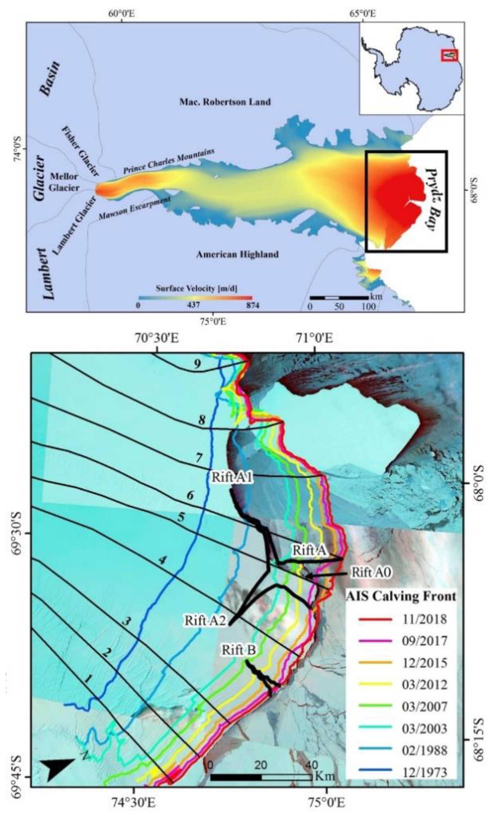
:
1. Introduction
2. Materials and Data
3. Results
4. Discussion
5. Conclusions
Funding
Institutional Review Board Statement
Informed Consent Statement
Data Availability Statement
Acknowledgments
Conflicts of Interest
References
- Thomas, R.H. Ice shelves: A review. J. Glaciol. 1979, 24, 273–286. [Google Scholar] [CrossRef]
- Liu, Y.; Moore, J.C.; Cheng, X.; Gladstone, R.M. Iceberg calving of Antarctic ice shelves. Proc. Natl. Acad. Sci. USA 2015, 112, 3263–3268. [Google Scholar] [CrossRef] [Green Version]
- Smith, B.; Fricker, H.A.; Gardner, A.S.; Medley, B.; Nilsson, J.; Paolo, F.S.; Holschuh, N.; Adusumilli, S.; Brunt, K.; Csatho, B.; et al. Pervasive ice sheet mass loss reflects competing ocean and atmosphere processes. Science 2020, 368, 1239–1242. [Google Scholar] [CrossRef]
- Alley, R.B.; Horgan, H.J.; Joughin, I.; Cuffey, K.M. A simple law for ice-shelf calving. Science 2008, 28, 1344. [Google Scholar] [CrossRef] [PubMed]
- Bassis, J.; Fricker, H.; Coleman, R.; Minster, J. An investigation into the forces that drive ice-shelf rift propagation on the Amery Ice Shelf, East Antarctica. J. Glaciol. 2008, 54, 17–27. [Google Scholar] [CrossRef] [Green Version]
- Fricker, H.A.; Young, N.W.; Allison, I.; Coleman, R. Iceberg calving from the Amery Ice Shelf, East Antarctica. Annu. Glaciol. 2002, 34, 241–246. [Google Scholar] [CrossRef] [Green Version]
- Walker, C.; Bassis, J.; Fricker, H.; Czerwinski, R. Observations of interannual and spatial variability in rift propagation in the Amery Ice Shelf, Antarctica, 2002–2014. J. Glaciol. 2015, 61, 243–252. [Google Scholar] [CrossRef] [Green Version]
- Zwally, H.J.; Beckley, M.A.; Brenner, A.C.; Giovinetto, M.B. Motion of major ice-shelf fronts in Antarctica from slant-range analysis of radar altimeter data, 1978–1998. Ann. Glaciol. 2002, 34, 255–262. [Google Scholar] [CrossRef] [Green Version]
- Budd, W. The dynamics of the Amery Ice Shelf. J. Glaciol. 1966, 6, 335–358. [Google Scholar] [CrossRef] [Green Version]
- Darji, S.; Oza, S.R.; Shah, R.D.; Rathore, B.P.; Bahuguna, I.M. Rift assessment and potential calving zone of Amery Ice Shelf, East Antarctica. Curr. Sci. 2018, 115, 1799–1804. [Google Scholar] [CrossRef]
- Fricker, H.A.; Young, N.W.; Coleman, R.; Bassis, J.N.; Minster, J.-B. Multi-year monitoring of rift propagation on the Amery Ice Shelf, East Antarctica. Geophys. Res. Lett. 2005, 32, L02502. [Google Scholar] [CrossRef] [Green Version]
- Zhao, C.; Cheng, X.; Liu, Y.; Hui, F.; Kang, J.; Wang, X.; Cheng, C. The slow-growing tooth of the Amery Ice Shelf from 2004 to 2012. J. Glaciol. 2013, 59, 592–596. [Google Scholar] [CrossRef] [Green Version]
- Baumhoer, C.A.; Dietz, A.J.; Dech, S.; Kuenzer, C. Remote sensing of Antarctic glacier and ice-shelf front dynamics—A review. Remote Sens. 2018, 10, 1445. [Google Scholar] [CrossRef] [Green Version]
- Liu, H.; Jezek, K.C.; Li, B. Development of an Antarctic digital elevation model by integrating cartographic and remotely sensed data: A geographic information system based approach. J. Geophys. Res. 1999, 104, 23199–23213. [Google Scholar] [CrossRef]


| Year/Month | Sensor | Band No. | No. of Scene(s) | Spatial Resolution (m) |
|---|---|---|---|---|
| 1973/12 | MSS | 7 | 1 | 60 |
| 1988/02 | TM | 6 | 2 | 120 |
| 2003/03 | ETM+ | 6 | 3 | 60 |
| 2007/03 | ETM+ | 6 | 2 | 60 |
| 2012/03 | ETM+ | 6 | 2 | 60 |
| 2015/12 | TIR | 10 | 1 | 100 |
| 2017/09 | TIR | 10 | 2 | 100 |
| 2018/11 | TIR | 10 | 2 | 100 |
Publisher’s Note: MDPI stays neutral with regard to jurisdictional claims in published maps and institutional affiliations. |
© 2021 by the authors. Licensee MDPI, Basel, Switzerland. This article is an open access article distributed under the terms and conditions of the Creative Commons Attribution (CC BY) license (https://creativecommons.org/licenses/by/4.0/).
Share and Cite
Chi, Z.; Klein, A. Understanding of an Iceberg Breaking Off Event Based on Ice-Front Motion Analysis of Amery Ice Shelf, Antarctica. Remote Sens. 2021, 13, 4983. https://doi.org/10.3390/rs13244983
Chi Z, Klein A. Understanding of an Iceberg Breaking Off Event Based on Ice-Front Motion Analysis of Amery Ice Shelf, Antarctica. Remote Sensing. 2021; 13(24):4983. https://doi.org/10.3390/rs13244983
Chicago/Turabian StyleChi, Zhaohui, and Andrew Klein. 2021. "Understanding of an Iceberg Breaking Off Event Based on Ice-Front Motion Analysis of Amery Ice Shelf, Antarctica" Remote Sensing 13, no. 24: 4983. https://doi.org/10.3390/rs13244983