Article

Identification of Vegetation Surfaces and Volumes by Height Levels in Reservoir Deltas Using UAS Techniques—Case Study at Gilău Reservoir, Transylvania, Romania

1
Faculty of Geography, Babeş-Bolyai University, 5-7 Clinicilor, 400006 Cluj-Napoca, Romania
2
Department of Geography, Faculty of Humanities, Valahia University of Targoviste, 130004 Targoviste, Romania
3
Faculty of Environmental Engineering and Food Science, Valahia University of Targoviste, 13 Aleea Sinaia, 130004 Targoviste, Romania
*
Authors to whom correspondence should be addressed.
Sustainability 2024, 16(2), 648; https://doi.org/10.3390/su16020648
Submission received: 9 June 2023 / Revised: 16 December 2023 / Accepted: 4 January 2024 / Published: 11 January 2024
(This article belongs to the Special Issue Water Resource Management and Sustainable Environment Development)

Abstract

:
The hydrophilic vegetation from reservoir deltas sustains rapid expansions in surface and important increases in vegetal mass against a background of a significant influx of alluvium and nutrients from watercourses. It contributes to reservoir water quality degradation and reservoir silting due to organic residues. In this paper, we propose an evaluation method of two-dimensional and three-dimensional parameters (surfaces and volumes of vegetation), using the combined photogrammetric techniques from the UAS category. Raster and vector data—high-resolution orthophotoplan (2D), point cloud (pseudo-LIDAR) (3D), points that defined the topographic surface (DTM—Digital Terrain Model (3D) and DSM—Digital Surface Model (3D))—were the basis for the realization of grid products (a DTM and DSM, respectively). After the successive completion of the operations within the adopted workflow (data acquisition, processing, post-processing, and their integration into GIS), after the grid analysis, the two proposed variables (topics) of this research, respectively, the surface of vegetation and its volume, resulted. The data acquisition area (deriving grids with a centimeter resolution) under the conditions of some areas being inaccessible using classical topometric or bathymetric means (low depth, the presence of organic mud and aquatic vegetation, etc.) has an important role in the reservoirs’ depth dynamics and reservoir usage. After performing the calculations in the abovementioned direction, we arrived at results of practical and scientific interest: Cut Volume = 196,000.3 m3, Cut 2D Surface Area = 63,549 m2, Fill Volume = 16.59998 m3, Fill 2D Surface Area = 879.43 m2, Total Volume Between Surfaces = 196,016.9 m3. We specify that this approach does not aim to study the vegetation’s diversity but to determine its dimensional components (surface and volume), whose organic residues participate in mitigating the reservoir functions (water supply, hydropower production, flash flood attenuation capacity, etc.).

1. Introduction

UAS techniques are implemented in more and more strategic and other areas of the civil sector, from the supervision of natural and anthropogenic risk events to territorial management and the delivery of products for commercial purposes, the latter being a new trend in drone utilization [1,2,3,4,5,6,7].
UAS technologies have been confirmed useful in the contemporary topometric context of field research. Thus, the use of this technology brings, on the one hand, extra accuracy, and, on the other hand, allows access in areas difficult to access (or areas inaccessible to classical topometric technology) [5,8,9,10,11,12,13].
Smaller aircrafts (UAVs) help to conduct field research, in the areas hard to reach for classic aircrafts, as they ensure independence, ease of operation, and very good accuracy (if properly equipped and calibrated), allowing a significant reduction in working time [5,10,14,15,16].
Numerous studies involving UAS techniques have been dedicated to natural hazards and risks in general, and hydrological ones in particular, as these phenomena need to be monitored and managed under the existing conditions of amplified climate change effects [17,18,19,20,21,22,23,24].
Performing several flights during flood periods facilitates good monitoring of flooded areas, sustaining optimal decisions in managing the post-flood situation [25,26,27,28].
Other profile studies are focused on various hydraulic models built from cartographic resources or medium- or high-resolution aerial images [9,29,30,31].
The implementation of UAS techniques is increasingly developing in the fields of resource prospecting, construction, technological management, and occupational safety due to the provided opportunities [32,33,34].
On the other hand, numerous applications of light flight techniques are implemented in forestry and agriculture, vegetation monitoring [35,36,37,38,39,40,41,42], as well as in the evaluation of forests’ status, implying the use of high-performance electro-optical sensors for near-infrared images [43].
The studies that have involved satellite and UAS technology have effectively focused on environmental components, including plant and wildlife habitats, wetlands, etc., have mainly been conducted in recent years, being targeted on current directions of interest [44,45,46,47,48,49].
The topometric products derived from the use of this technology can be classified (in our case) into two broad categories [50,51]:
-
Products providing 2D planimetric information (x, y) (example: orthophotoplan, etc.).
-
Products providing 3D altimetric information (x, y, z) (DEM, DSM, 3D model, etc.).
The accuracy of the final products will be determined, on the one hand, using the photometric equipment used for data acquisition (camera, sensor, etc.) and, on the other hand, by the optimal planning of the flight mission. Last but not least, it is very important to process the data knowingly (photogrammetric procedures and software used) [9,10,11,12,13,23,42,52,53].
Finally, the data integration into the GIS environment to capitalize the research results, followed by spatial analysis, represents the last research step.
The confluence, or the discharge areas in general and the deltaic areas in particular, have some topometric, geological, and geomorphological specifications:
-
They are hard-to-reach areas (sometimes inaccessible);
-
They are very dynamic areas, as from the point of view of the substrate they are the result of the continuous sedimentation–erosion game.
Their monitoring is more difficult precisely because of this dynamism but also owing to the difficult direct access caused by the presence of swampy terrain and land in formation and consolidation. Under these circumstances, UAS techniques become extremely useful and efficient [54,55].
Also, the huge amounts of seasonal vegetation, which rapidly and consistently grow on the substrate of recent sediments and unconsolidated slime, loaded with nutrients, annually increase the amount of organic mud, which contributes to the deterioration of the water quality, accelerating the silting of the lake sector [56,57].
Based on these considerations, this article proposes a method of precise determination of the two- and three-dimensional parameters (areas and volumes of vegetation) using combined photogrammetric techniques such as UAS.
Our methodological approach starts from a very simple logic. Once the resulting DTM and DSM grids are integrated into a GIS environment, they can be compared. Therefore, from the grid representing the DSM, we subtracted the grid representing the DTM. Consequently, the current volume of vegetation is obtained since only vegetation is present in the area of interest (AOI), without any other anthropogenic interference. We underline that this approach does not aim to study the diversity of the vegetation but to determine its dimensional metric components (surface and volume), whose organic residues participate in mitigating the reservoir functions (water supply, hydro-power production, flash flood attenuation capacity, etc.). We mention that, in our opinion, the contribution of this approach is substantial in areas inaccessible using classical topometric means.

The Study Area

The Somesul Rece Delta has developed at the confluence of the two arranged watercourses (Someșul Cald and Someșul Rece), which form the Someșul Mic River at the exit of the Apuseni Mountains (Transylvania, Romania), under the effect of the combined alluvial transport of rivers and of the Gilău reservoir silting (Figure 1) [8,9,57].
Starting from the year 1972, the year of it being put into use, the Gilău reservoir was used as the main surface source for the water supply of almost an entire county (Cluj County—currently 6.674 km2, representing 2.8% of Romanian territory), resulting in its strategic importance for the mentioned area [57].

2. Materials and Methods
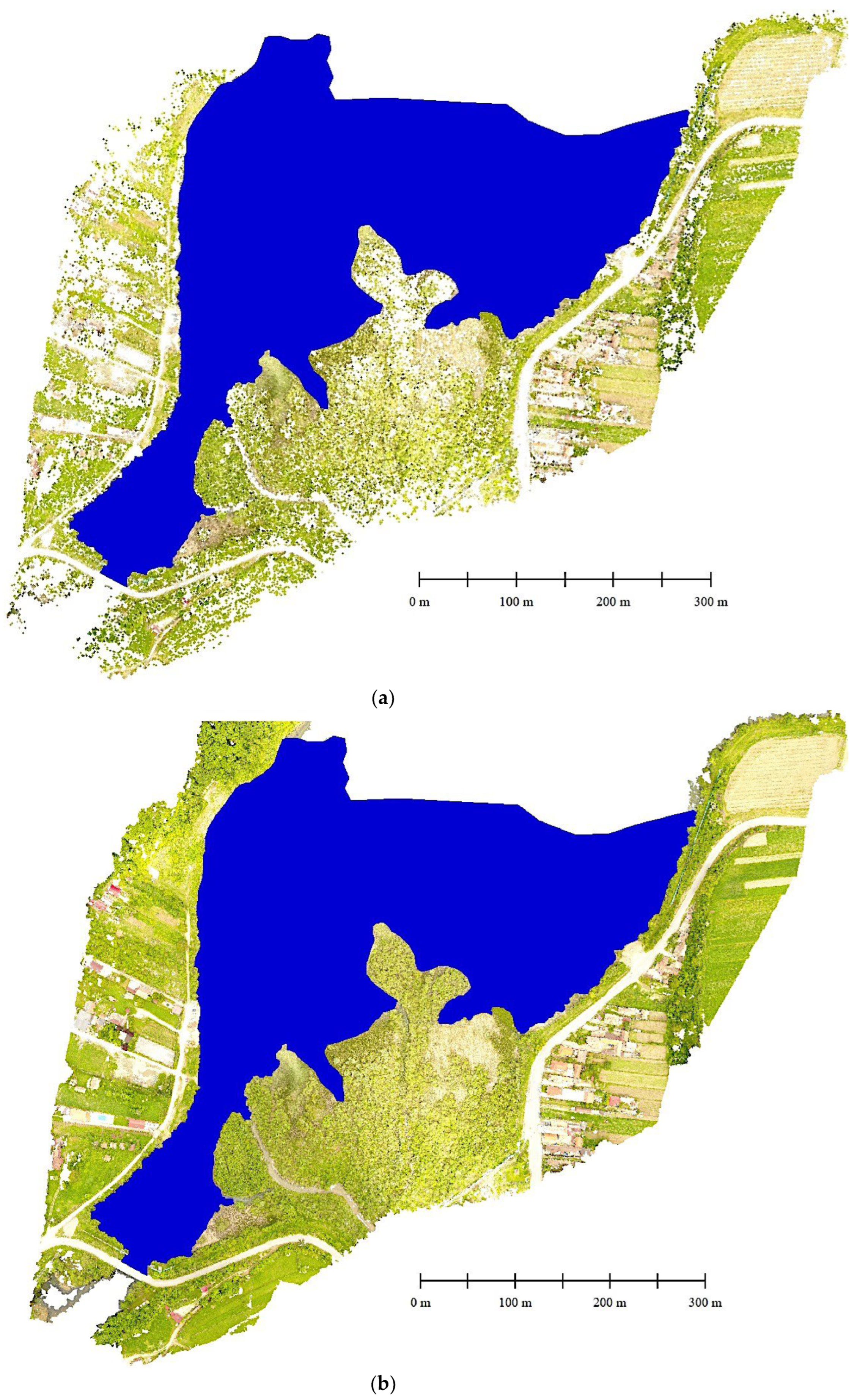
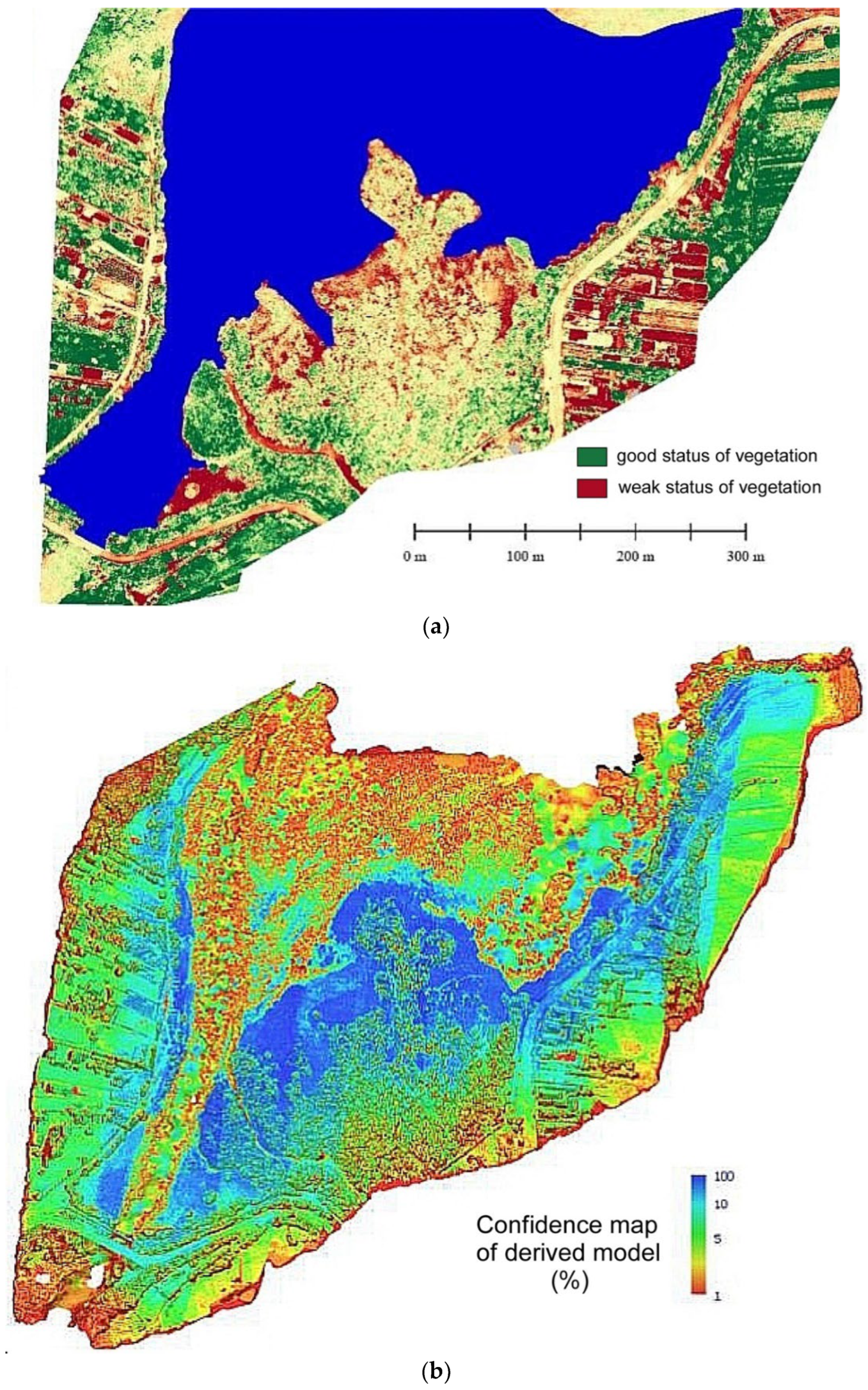
For the thematic framing of the study, specialized literature was used, respectively, the Web of Science and ScienceDirect databases, and also the national bibliographic support provided by the Babeș-Bolyai University, e.g., studies, maps, and other materials, etc.
For general cartographic support, the Digital Elevation Model of Europe (EU-DEM), 2017, and Topographic Map of Romania, 1:25,000, 1978–1982, were used, together with our own observations of the hydrographic basin afferent to the study area.
For the processing of the general and thematic information, software purchased by Babeș-Bolyai University and the Faculty of Geography, as well as software related to the used equipment and proprietary or free/open source software, was used: Microsoft Excel 2016, ESRI ArcGIS 10.8.1, DJI GO 4, Pix4Dcapture, Agisoft Metashape, and Global Mapper.
For the purpose of this research (determinations of surfaces and volumes related to the vegetation developed in the study area), a methodology inspired by the principles of digital photogrammetry assisted using UAS was used. Therefore, the grid representing the DTM was subtracted from the grid representing the DSM. Consequently, the volume of vegetation was obtained, since only vegetation is present in the area of interest (AOI), without other anthropogenic interference.
A commercial Phantom 4 Pro drone, produced by the DJI manufacturer, was used to acquire the photogrammetric data (Figure 2).
This device belongs to the category of microdrones [57], and its characteristics can be observed on the manufacturer’s website [61,62].
Compared to other microdrones, the passive sensor (camera) of the Phantom 4 Pro has a mechanical trigger (shooter) and not an electronic one. This fact leads to the elimination of pillow-type distortions, which appear on the periphery of the captured scenes. Another important feature is the 1-inch sensor, which guarantees a real 20 MP resolution.
Calibration of the Phantom 4 Pro camera, regarding the specific coefficients, led to the following results (Table 1).
Figure 3 shows that the effect of calibration is the relatively balanced distribution of errors on the surface of the captured image, which avoids their massive concentration in the marginal area, as well as in the ordinary photos.
Following the characteristics of the drone objective (Phantom 4 Pro type camera), we conditioned an 85% front lap and a 75% side lap, to ensure a sufficient density of information to obtain a high-accuracy model (Figure 4a,b).
Regarding the measurements and further data processing, the working methodology involved the following approach (Table 2).
Starting with the stage of mission preparation, the existence in the south–southeast part of the studied perimeter of a network of high-voltage power lines was taken into account, which conditioned the flight at a relative altitude of approximately 130 m. Thus, electromagnetic interference was avoided, as it can influence the RC equipment [57].
The accuracy of the inputs used in spatial analysis is very important. To check the reliability of the products used in the analysis, it was necessary to derive two additional products. Consequently, we used a synthetic NDVI (known as a “false NDVI”).
This indicator is based on the principle that it can be derived using RGB scenes. Compared to the classic NVDI, obtaining this indicator is much easier, as it does not require a multispectral camera. Some specialists say that the accuracy of the synthetic NDVI is not as high as the accuracy of the classic NDVI (which also includes the NIR band), but in terms of efficiency, this indicator is very appropriate.
The synthetic NDVI is based on the VARI (Visible Atmospherically Resistant Index) algorithm, expressed by Equation (1)
VARI = (Green − Red)/(Green + Red − Blue),

3. Results

After the flight, the data were downloaded to a computer and processed, obtaining several derived products.
Based on the acquired images in the visible spectrum, the raster data results were as follows:
-
High-resolution orthophoto plan (2D);
-
Point cloud (pseudo-LIDAR) (3D).
Based on the point cloud classification, we were able to separate at least two major categories:
-
Points that define the topographic surface (DTM—Digital Terrain Model) (3D);
-
Points that define the surface occupied by the elements above the topographic one (including vegetation and anthropogenic objectives) (DSM—Digital Surface Model) (3D).
Based on these raster products derived from the point cloud, grid-type products can be generated, which are suitable for operations in a GIS environment.
Consequently, after we obtain the two grids (the DTM and DSM, respectively), the analysis of the grid will show the two dimensions: the planimetric surface occupied by vegetation and the volume, respectively.
The spatial distribution of the residues for the study area presents a favorable configuration for the development of advanced processing stages of the materials obtained after the overflight (Figure 5):
As a component of the results, the average values of the estimated errors are within reasonable limits (Table 3).
During the processing of the photograms, the following conditions were rigorously adhered to:
-
Coplanarity condition;
-
Relative orientation;
-
Absolute orientation.
The simple point cloud was the first product derived from this processing. This product is the framework for subsequent planimetric and altimetric determinations and for the densified point cloud. Each point has Cartesian information (x, y, z) and color information (RGB) (Figure 6).
Based on the densified point cloud product, the DSM surface was generated using a micro-triangulation process.
To characterize the status of the vegetation in the studied area, we used two more raster products: the high-resolution orthophotoplan and the DTM (Digital Terrain Model).
Determining the DTM in this way involves returning to the densified point cloud and performing an automatic classification of the existing points.
As a component of the results, following this classification, we were able to separate the points that referred to constructions, land, high vegetation, low vegetation, and roads. The spatial distribution of these distinct points is shown in Figure 7.
Once the spatial configuration of each class is obtained, it is possible to obtain the DTM using micro-triangulation of the specific terrain points (Figure 8).
A high-resolution orthophotoplan of the studied area was derived as well (Figure 9).
Our approach started with the assumption that is possible to assess quantitatively the vegetation developed at the river mouth of the Someșul Rece, where the alluvial deposits have formed a real lake delta over time. For this purpose, because of the difficult conditions in the field (listed in the introductory part), we used UAS technology and the photogrammetric study type.
Similar approaches have been developed by some authors [63,64], but they have generally focused on obtaining photogrammetrically derived products (orthophotoplan, DSM, DTM), without exploiting these products in thematic applications (e.g., obtaining the NDVI, surface and volume of biomass, etc.).
As can be seen in Figure 10, the model’s reliability is low at the water surface (only a few percent) and of high and very high quality in the dry and semi-dry areas of the mouth.This was fully anticipated, knowing that the water surface is one of the most difficult things to model in 3D using photogrammetric techniques due to the high degree of reflectance and due to its excessive mobility (waves, currents, etc.).
Given these considerations, we presented several other conditions.
In the first phase, we selected the actual confluence area, which we delimited strictly on the boundary of the land surface to proceed with the grid operations. In this way, the analysis gained accuracy, and the inputs could be integrated into a GIS environment (Figure 11).
Because the distribution of vegetation is relatively easy to determine based on the high-resolution orthophotoplan and the synthetic NDVI, we also ensured a vertical “scan” of the vegetation. This was made possible by overlapping the previously determined elevation models (the DSM and DTM, respectively).
Subsequently, the elements could be highlighted by analyzing the overlapping profiles. Upon careful analysis, the height of the trees located in the profile alignment can be discerned.
Using extrapolation, we applied the same principle, but, this time, to the whole area of interest. In this sense, we compared the two surfaces: respectively, the DSM surface assimilated with the vegetation, and the DTM surface assimilated with the land (Figure 12).
After performing the calculations in the abovementioned direction, we arrived at results of practical and scientific interest (Table 4 and Figure 13).

4. Discussion

The vegetation of the deltas developed in reservoirs is of less interest, or even of negative interest, to institutional water administrators, as their primary interest is the good quality of water and the low silting rate of these water bodies, to capitalize for as long as possible and at a high efficiency on their capacity (useful volume) [57].
Or, as could be seen previously, these organic residues, together with their alluvium quantities, participate in mitigating reservoir functions (water supply, hydro-power production, flash flood attenuation capacity, etc.) [56,57]. However, the vegetation contributes to the retention of a great part of these significant quantities of alluvium transported by flash floods, and alluviums that contribute to the evolution/growth of the deltas.
On the other hand, the vegetation, especially when developed/tall, fully contributes to an increase in biodiversity in the delta area, favoring the development of more and more complex ecosystems and an increase in the occupied space. In the case of the Gilău reservoir delta, species unknown before began to appear before the development of the sedimentation space, even if temporarily (pelicans, swans, etc.), and seagulls, wild ducks, etc. have been registered for decades at the current site.
Compared to these previously mentioned elements, some authors have focused on studying several aspects related to wetlands, such as, for example, the soil conditions, as support for the evolution of the vegetation. Visible-near-infrared (Vis-NIR) spectroscopy has been considered an alternative to building spectral libraries, which couple soil data and Vis-NIR spectra using models. These models can provide optimal predictions for topsoil expansion [65].
Other authors have considered the accurate prediction of clay to be the basis for the assessment of soil quality because it governs the soil moisture and fertility dynamics, with an effect on the development of vegetation, including from wetlands, in the primary soils of the silt category. Research results have shown that γ-ray data were the most important for the prediction of topsoil, while in the subsoil, the slope was the most important [66].
Extensive wetlands play a crucial role in the global carbon cycle. Aboveground vegetation biomass (AGB) is a critical indicator of carbon storage in wetland ecosystems [67]. Some authors, using the normalized difference vegetation index (NDVI), climate data, and measured AGB data, have investigated the temporal and spatial variation in marsh AGB and its response to climate change, with the results demonstrating a good correlation between the AGB and annual maximum NDVI (NDVImax) [67].
Vegetation activity and phenology are significantly affected by climate change, and changes in vegetation activity and phenology can, in turn, affect local, regional, and global climate patterns. Using the observation minus reanalysis (OMR) method, some authors have investigated the possible effects of vegetation activity and changes in the growing season on the air temperature of the respective areas [68]. The results have showed that the average NDVI of certain vegetated areas increased significantly, and the growing season started earlier and ended later, resulting in its extension. The results suggest that climate-change-induced increases in vegetation activity and extended growing seasons may further exacerbate regional warming [68].
Wetlands not only affect local hydrology and ecosystems but also regulate human environmental conditions [69]. Some authors have demonstrated that wetland mapping, which is based on Google Earth Engine (GEE), feature optimization, and a random forest (RF) model (GFORF), provides new perspectives on studying them. The results obtained showed that the overall accuracy for wetland data was 82.73%, 83.16%, 82.47%, and 88.14% across the interval 1990–2010 [69]. As a result of improving the accuracy of wetland mapping, it is possible to identify the dynamics of wetlands, which justifies the implementation of ecological services and protection measures in this category of study [69].
Various studies have shown that forest biomass is a key biophysical parameter for studying climate change, ecological modeling, and forest management [70]. Compared with discrete return LiDAR data, full-waveform LiDAR data can provide more accurate and abundant information on the vertical structure of vegetation and thus have been increasingly applied to forest aboveground biomass (AGB) estimation [70].
Estimating the structural attributes of forests is crucial for their sustainable management and helps us to understand their contributions to global carbon storage [71]. Unmanned Aerial Vehicle Light Detecting and Ranging (UAV LiDAR) has become a promising technology and is being tested for use for forest management due to its ability to provide highly accurate estimates of three-dimensional (3D) structural information at a lower cost, greater flexibility, and finer resolution than airborne LiDAR [71].
Individual tree detection based on a combination of Unmanned Aerial Vehicle Light Detecting and Ranging (UAV LiDAR) with Backpack LiDAR is another application of airborne technology, with high potential for accurate forest AGB estimation [55].
Other authors have tried to analyze the error range and resolution of drone images using a rotary wing, comparing them with the results of field measurements, and to analyze the stand patterns in the actual preparation of a vegetation map, comparing drone images with the aerial images provided by national specialized institutes [63]. The spatial analyses carried out concluded that the drone images made more accurate polygons than the 51 and 25 cm resolution images provided by the mentioned institutes [63].
The confluence of discharge areas in general, and the deltaic areas of the type related to the Gilău reservoir in particular, is hard to reach (sometimes inaccessible) and dynamic, as, from the point of view of the substrate, they are the result of a continuous sedimentation–erosion game. Monitoring them is more difficult precisely because of this dynamism but also owing to the difficult direct access caused by the presence of swampy terrain and land in formation and consolidation. It is due to these reasons that UAS techniques become extremely useful and efficient.
This type of area, located at the confluence of rivers and reservoirs, stores quantities of water that are difficult to quantitatively and qualitatively assess, recoverable for everyday use (water supply), hydropower, or involved in the process of the attenuation of flood waves (on this altimetric scale, the tranche of the characteristic volume of the same name is present).
Emerged and submerged seasonal vegetation, which grows rapidly and consistently on the substrate built from recent sediments, full of nutrients and unconsolidated mud, annually increases the amount of organic mud, which contributes to deteriorating the water quality and accelerating the silting of the lake sector.
The method proposed in this article is an obvious one in the low-cost category, with extremely easy applicability and which requires a relatively low workload. The technological flow of obtaining the finished product involves the automatic collection of aerial images, automatic downloading to the digital environment, processing using photogrammetric software, and obtaining derived products using the different models established in the specialized literature [8]:
-
3D reconstruction process based on UAV technology (drone) and the interpolation algorithm ‘‘Daisy’’ is cheap, relying on open-source solutions;
-
The accuracy of 3D reconstruction (5 cm) is much higher than traditional photogrammetric solutions;
-
The final product (DEM, DSM, orthophotoplan, false NDVI, vegetation grid, etc.) can be georeferenced and integrated into any GIS or CAD application;
-
This process allows an accurate qualitative and quantitative approach (distance, area, volume);
-
The procedure is of a non-invasive nature and is applicable in areas difficult to reach or inaccessible using traditional technology.
Some disadvantages of applying this technology are as follows:
-
Flights cannot be executed in conditions of winds over 60 km/h and in unfavorable light conditions; for this study, the flight was executed in calm weather conditions;
-
The flight autonomy is relatively low on the battery unit (under 40 min) to avoid system collapse and sustaining significant damage; instead, more batteries can be bought to change them every 30 min;
-
A low environment temperature is unfavorable, resulting in faster battery consumption;
-
Significant hardware resources are required in processing the data: in this case, a computer system including but not limited to an Intel i7/AMD Ryzen processor, 32 GB RAM, a video card of 16 GB, and a 2 TB SSD.

5. Conclusions

Following the proposed topic (determination of areas and volumes related to the vegetation developed in the study area), a methodology inspired by the principles of digital photogrammetry, assisted by UAV, was used. The succession of operations within the adopted workflow was successfully followed.
After the field stage and after the downloading and processing of data, several high-resolution derivative products were obtained, vector (dot) and raster (orthophotoplan, grid) products, subsequently integrated into the GIS environment.
As an additional element of validation and verification, an NDVI was derived to identify the status of vegetation and its distribution in the plan (2D distribution of information), followed by checking the reliability of the model resulting from the research (3D distribution of information).
The objective of the research was achieved by comparing, following the spatial analysis, the two surfaces—the surface assimilated to the vegetation (DSM) and the surface assimilated to the terrain (DTM), including at the level of transverse profiles over the delta area. The results reveal the values of the final parameters (volumes and areas of the emerged vegetation). Beyond these values, we expect the development of the methodology, which will make possible the calculation of the vegetal mass developed in this area based on its density.

Author Contributions

Conceptualization, I.R., G.Ș., P.B., D.D. and D.S.; formal analysis, I.R., G.Ș., P.B., D.D. and D.S.; investigation, I.R., G.Ș., P.B., D.D. and D.S.; methodology, I.R., G.Ș., P.B., D.D. and D.S.; software, I.R., G.Ș., P.B., D.D. and D.S.; validation, I.R., G.Ș., P.B., D.D. and D.S.; writing—original draft, I.R., G.Ș., P.B., D.D. and D.S. All authors have read and agreed to the published version of the manuscript.

Funding

This research received no external funding.

Institutional Review Board Statement

Not applicable.

Informed Consent Statement

Not applicable.

Data Availability Statement

Data is contained within the article.

Acknowledgments

The authors want to thank Babeș-Bolyai University for offering its technical support (the software support and the PC techniques available for modeling) and the academic and scientific conditions (literature and database access) for preparing this paper.

Conflicts of Interest

The authors declare no conflict of interest.

References

  1. Dalamagkidis, K.; Valavanis, K.P.; Piegl, L.A. On unmanned aircraft systems issues, challenges and operational restrictions preventing integration into the National Airspace System. Prog. Aerosp. Sci. 2008, 44, 503–519. [Google Scholar] [CrossRef]
  2. Barmpounakis, E.N.; Yannis, G.; Golias, J. Unmanned Aerial Aircraft Systems for transportation engineering: Current practice and future challenges. Int. J. Transp. Sci. Technol. 2016, 5, 111–122. [Google Scholar] [CrossRef]
  3. McFadyen, A.; Mejias, L. A survey of autonomous vision-based See and Avoid for Unmanned Aircraft Systems. Prog. Aerosp. Sci. 2016, 80, 1–17. [Google Scholar] [CrossRef]
  4. Washington, A.; Clothier, R.A.; Silva, J.R. A review of unmanned aircraft system ground risk models. Prog. Aerosp. Sci. 2017, 95, 24–44. [Google Scholar] [CrossRef]
  5. Hackl, J.; Adey, B.T.; Woźniak, M.; Schümperlin, O. Use of Unmanned Aerial Vehicle Photogrammetry to Obtain Topographical Information to Improve Bridge Risk Assessment. J. Infrastruct. Syst. 2018, 24. [Google Scholar] [CrossRef]
  6. Hovrtek. An A-Z Glossary of Drone Terminology. 2019. Available online: https://www.hovrtek.com/drone-operations/drone-terminology/ (accessed on 10 August 2020).
  7. Darvishpoor, S.; Roshanian, J.; Raissi, A.; Hassanalian, M. Configurations, flight mechanisms, and applications of unmanned aerial systems: A review. Prog. Aerosp. Sci. 2020, 121, 100694. [Google Scholar] [CrossRef]
  8. Serban, G.; Rus, I.A.; Vele, D.; Breţcan, P.; Alexe, M.; Petrea, D. Flood-prone area delimitation using UAV technology, in the areas hard-to-reach for classic aircrafts: Case study in the north-east of Apuseni Mountains, Transylvania. Nat. Hazards 2016, 82, 1817–1832. [Google Scholar] [CrossRef]
  9. Șerban, G.; Rus, I.A.; Niţoaia, A.; Vele, D. Preliminary results in assessing flood-prone areas using UAS System within the Ozana River Upper Basin (the Eastern Carpathians). Revista Forum Geografic 2017, XVI, 102–112. [Google Scholar] [CrossRef]
  10. Coveney, S.; Roberts, K.B. Lightweight UAV digital elevation models and orthoimagery for environmental applications: Data accuracy evaluation and potential for river flood risk modelling. Int. J. Remote Sens. 2017, 38, 3159–3180. [Google Scholar] [CrossRef]
  11. Govedarica, M.; Jakovljević, G.; Álvarez-Taboada, F. Flood risk assessment based on LiDAR and UAV points clouds and DEM. In Proceedings of the SPIE 10783, Remote Sensing for Agriculture, Ecosystems, and Hydrology XX, 107830B, Berlin, Germany, 10 October 2018. [Google Scholar] [CrossRef]
  12. Dyer, J.L.; Moorhead, R.J.; Hathcock, L. Identification and Analysis of Microscale Hydrologic Flood Impacts Using Unmanned Aerial Systems. Remote Sens. 2020, 12, 1549. [Google Scholar] [CrossRef]
  13. Kerle, N.; Heuel, S.; Pfeifer, N. Real-Time Data Collection and Information Generation using Airborne Sensors. In Geospatial Information Technology for Emergency Response; Li, J., Zlatanova, S., Eds.; ISPRS Book series; 6; Taylor & Francis: Leiden, The Netherlands, 2008; pp. 43–74. Available online: https://ezproxy2.utwente.nl/login?url=https://webapps.itc.utwente.nl/library/2008/chap/kerle_rea.pdf (accessed on 3 May 2021).
  14. Choi, K.; Lee, I.; Hong, J.; Oh, T.; Shin, S. Developing a UAV-based Rapid Mapping System for Emergency Response. In Proceedings of SPIE; SPIE: Bellingham, WA, USA, 2009. [Google Scholar] [CrossRef]
  15. Roeoesli, C. Processing of UAV-Images: In Samoilov Island; Institute of Geodesy and Photogrammetry, ETH Zurich: Zürich, Switzerland, 2009; p. 46. [Google Scholar]
  16. Remondino, F.; El-Hakim, S.F.; Girardi, S.; Rizzi, A.; Benedetti, S.; Gonzo, L. 3D Virtual reconstruction and visualization of complex architectures: The 3D-ARCH project. Int. Arch. Photogramm. Remote Sens. Spat. Inf. Sci. 2009, 38, 1–9. [Google Scholar] [CrossRef]
  17. Restás, Á. Drone Applications for Supporting Disaster Management. World J. Eng. Technol. 2015, 3, 316–321. [Google Scholar] [CrossRef]
  18. Giordan, D.; Hayakawa, Y.S.; Nex, F.; Remondino, F.; Tarolli, P. Review article: The use of remotely piloted aircraft systems (RPASs) for natural hazards monitoring and management. Nat. Hazards Earth Syst. Sci. 2017, 18, 1079–1096. [Google Scholar] [CrossRef]
  19. Hashemi-Beni, L.; Jones, J.A.; Thompson, G.M.; Johnson, C.; Gebrehiwot, A. Challenges and Opportunities for UAV-Based Digital Elevation Model Generation for Flood-Risk Management: A Case of Princeville, North Carolina. Sensors 2018, 18, 3843. [Google Scholar] [CrossRef] [PubMed]
  20. Langhammer, J.; Vacková, T. Detection and Mapping of the Geomorphic Effects of Flooding Using UAV Photogrammetry. Pure Appl. Geophys. 2018, 175, 3223–3245. [Google Scholar] [CrossRef]
  21. Yalcin, E. Two-dimensional hydrodynamic modelling for urban flood risk assessment using unmanned aerial vehicle imagery: A case study of Kirsehir, Turkey. J. Flood Risk Manag. 2019, 12, e12499. [Google Scholar] [CrossRef]
  22. Villanueva, J.L. Contribuciones Metodológicas Para la Obtención de Información Altimétrica Requerida en la Evaluación Local de Amenazas por Inundaciones a Partir de Nuevas Tecnologías Geoespaciales. Ph.D. Thesis, E.T.S.I. de Minas y Energía (UPM), Madrid, Spain, 2020. [Google Scholar] [CrossRef]
  23. Salmoral, G.; Casado, M.R.; Muthusamy, M.; Butler, D.; Menon, P.P.; Leinster, P. Guidelines for the Use of Unmanned Aerial Systems in Flood Emergency Response. Water 2020, 12, 521. [Google Scholar] [CrossRef]
  24. Dunea, D.; Bretcan, P.; Purcoi, L.; Tanislav, D.; Serban, G.; Neagoe, A.; Iordache, V.; Iordache, Ș. Effects of riparian vegetation on evapotranspiration processes and water quality of small plain streams. Ecohydrol. Hydrobiol. 2021, 21, 629–640. [Google Scholar] [CrossRef]
  25. Hervouet, A.; Dunford, R.G.; Piégay, H.; Belletti, B.; Trémélo, M. Analysis of Post-flood Recruitment Patterns in Braided-Channel Rivers at Multiple Scales Based on an Image Series Collected by Unmanned Aerial Vehicles, Ultra-light Aerial Vehicles, and Satellites. Gisci. Remote Sens. 2011, 48, 50–73. [Google Scholar] [CrossRef]
  26. Taubenböck, H.; Wurm, M.; Netzband, M.; Zwenzner, H.; Roth, A.; Rahman, A.; Dech, S. Flood risks in urbanized areas—Multi-sensoral approaches using remotely sensed data for risk assessment. Nat. Hazards Earth Syst. Sci. 2011, 11, 431–444. [Google Scholar] [CrossRef]
  27. Abdelkader, M.; Shaqura, M.; Claudel, C.; Gueaieb, W. A UAV Based System for Real Time Flash Flood Monitoring in Desert Environments using Lagrangian Microsensors. In Proceedings of the 2013 International Conference on Unmanned Aircraft Systems (ICUAS), Atlanta, GA, USA, 28–31 May 2013; pp. 25–34. [Google Scholar] [CrossRef]
  28. Abdelkader, M.; Shaqura, M.; Ghommem, M.; Collier, N.; Calo, V.; Claudel, C. Optimal Multi-Agent Path Planning for Fast Inverse Modeling in UAV-Based Flood Sensing Applications. In Proceedings of the 2014 International Conference on Unmanned Aircraft Systems (ICUAS), Orlando, FL, USA, 27–30 May 2014. [Google Scholar] [CrossRef]
  29. Sanders, R.; Shaw, F.; MacKay, H.; Galy, H.; Foote, M. National flood modelling for insurance purposes: Using IFSAR for flood risk estimation in Europe. Hydrol. Earth Syst. Sci. 2005, 9, 449–456. [Google Scholar] [CrossRef]
  30. Pappenberger, F.; Matgen, P.; Beven, K.; Henry, J.; Pfister, L.; De Fraipont, P. Influence of uncertain boundary conditions and model structure on flood inundation predictions. Adv. Water Resour. 2006, 29, 1430–1449. [Google Scholar] [CrossRef]
  31. Chevereşan, B.A. Acurateţea MNT Pentru Definirea Zonelor Inundabile [DTM Accuracy for Defining Floodplains]. Ph.D. Dissertation, Universitatea Tehnica de Constructii Bucuresti, Facultatea de Hidrotehnica, București, Romania, 2011. Available online: https://www.scribd.com/doc/254184909/Rez-Cheveresan-Bogdan-LIDAR-pdf (accessed on 3 May 2021). (In Romanian).
  32. Madjid, M.; Vandeginste, V.; Hampson, G.; Jordan, C.; Booth, A.W. Drones in carbonate geology: Opportunities and challenges, and application in diagenetic dolomite geobody mapping. Mar. Pet. Geol. 2018, 91, 723–734. [Google Scholar] [CrossRef]
  33. Zekkos, D.; Greenwood, W.; Lynch, J.P.; Manousakis, J.; Athanasopoulos-Zekkos, A.; Clark, M.K.; Cook, K.H.; Saroglou, C. Lessons Learned from the Application of UAV-Enabled Structure-From-Motion Photogrammetry in Geotechnical Engineering. ISSMGE Int. J. Geoengin. Case Hist. 2018, 4, 254–274. [Google Scholar] [CrossRef]
  34. Nnaji, C.; Okpala, I.; Awolusi, I. Wearable Sensing Devices: Potential Impact & Current Use for Incident Prevention. OnePetro 2020, 65, 16–24. Available online: https://onepetro.org/PS/article-abstract/65/04/16/33391/Wearable-Sensing-Devices-Potential-Impact-amp?redirectedFrom=fulltext (accessed on 3 May 2021).
  35. Sugiura, R.; Noguchi, N.; Ishii, K. Remote-sensing Technology for Vegetation Monitoring using an Unmanned Helicopter. Biosyst. Eng. 2005, 90, 369–379. [Google Scholar] [CrossRef]
  36. Hunt, E.R., Jr.; Hively, W.D.; Fujikawa, S.J.; Linden, D.S.; Daughtry, C.S.T.; McCarty, G.W. Acquisition of NIR-Green-Blue Digital Photographs from Unmanned Aircraft for Crop Monitoring. Remote Sens. 2010, 2, 290–305. [Google Scholar] [CrossRef]
  37. Meneses, N.; Brunner, F.; Baier, S.; Geist, J.; Schneider, T. Quantification of Extent, Density, and Status of Aquatic Reed Beds Using Point Clouds Derived from UAV–RGB Imagery. Remote Sens. 2018, 10, 1869. [Google Scholar] [CrossRef]
  38. Fake, M. Unmanned Aerial System Derived Multi-Spectral Imagery for the Monitoring of Coastal Dune Plant Communities. Master’s Thesis, Lincoln University, Lincoln, New Zealand, 2019. [Google Scholar]
  39. Lin, J.; Zhou, X.; Deng, S.; Du, X.; Wang, M.; Xinjuan, L.I. Inspecting Unattended Irrigation Canals of Dujiangyan in Mountainous Area with UAV Remote Sensing Technology. In Proceedings of the 2019 8th International Conference on Agro-Geoinformatics (Agro-Geoinformatics), Istanbul, Turkey, 16–19 July 2019. [Google Scholar] [CrossRef]
  40. O’Hara, R. The Application of Earth Observation for Mapping Soil Saturation and the Extent and Distribution of Artificial Drainage on Irish Farms. Ph.D. Dissertation, National University of Ireland Maynooth, Maynooth, Ireland, 2019. Available online: https://mural.maynoothuniversity.ie/11883/1/Rob%20O%27Hara%20PhD%202019.pdf (accessed on 3 May 2021).
  41. Taravat, A.; Wagner, M.; Oppelt, N. Automatic Grassland Cutting Status Detection in the Context of Spatiotemporal Sentinel-1 Imagery Analysis and Artificial Neural Networks. Remote Sens. 2019, 11, 711. [Google Scholar] [CrossRef]
  42. Wagner, M.; Oppelt, N. Extracting Agricultural Fields from Remote Sensing Imagery Using Graph-Based Growing Contours. Remote Sens. 2020, 12, 1205. [Google Scholar] [CrossRef]
  43. Watts, A.C.; Ambrosia, V.G.; Hinkley, E. Unmanned Aircraft Systems in Remote Sensing and Scientific Research: Classification and Considerations of Use. Remote Sens. 2012, 4, 1671–1692. [Google Scholar] [CrossRef]
  44. Pajares, G. Overview and Current Status of Remote Sensing Applications Based on Unmanned Aerial Vehicles (UAVs). Photogramm. Eng. Remote Sens. 2015, 81, 281–330. [Google Scholar] [CrossRef]
  45. Meneses, N.; Baier, S.; Reidelstürz, P.; Geist, J.; Schneider, T. Modelling heights of sparse aquatic reed (Phragmites australis) using Structure from Motion point clouds derived from Rotary- and Fixed-Wing Unmanned Aerial Vehicle (UAV) data. Limnologica 2018, 72, 10–21. [Google Scholar] [CrossRef]
  46. Liu, T.; Abd-Elrahman, A. Multi-view object-based classification of wetland land covers using unmanned aircraft system images. Remote Sens. Environ. 2018, 216, 122–138. [Google Scholar] [CrossRef]
  47. Fritz, C.; Dörnhöfer, K.; Schneider, T.; Geist, J.; Oppelt, N. Sentinel-2 for mapping the spatio-temporal development of submerged aquatic vegetation at Lake Starnberg (Germany). J. Limnol. 2019, 78, 71–91. [Google Scholar] [CrossRef]
  48. Green, D.; Hagon, J.J.; Gómez, C.A.; Gregory, B.J. Using Low-Cost UAVs for Environmental Monitoring, Mapping, and Modelling: Examples from the Coastal Zone. In Elsevier eBooks; Academic Press: Cambridge, MA, USA, 2019; pp. 465–501. [Google Scholar] [CrossRef]
  49. Alvarez-Vanhard, E.; Houet, T.; Mony, C.; Lecoq, L.; Corpetti, T. Can UAVs fill the gap between in situ surveys and satellites for habitat mapping? Remote Sens. Environ. 2020, 243, 111780. [Google Scholar] [CrossRef]
  50. Wang, D.; Song, Q.; Liao, X.; Ye, H.; Shao, Q.; Fan, J.; Cong, N.; Xin, X.; Yue, H.; Zhang, H. Integrating satellite and unmanned aircraft system (UAS) imagery to model livestock population dynamics in the Longbao Wetland National Nature Reserve, China. Sci. Total Environ. 2020, 746, 140327. [Google Scholar] [CrossRef]
  51. Wikantika, K. Three-Dimensional City Building Modellingwith Lidar Data (Case Study: Ciwaruga, Bandung). In Proceedings of the Asian Conference on Remote Sensing, Kuala Lumpur, Malaysia, 15–19 October 2018. [Google Scholar] [CrossRef]
  52. Mazzoleni, M.; Paron, P.; Reali, A.; Juizo, D.; Manane, J.; Brandimarte, L. Testing UAV-derived topography for hydraulic modelling in a tropical environment. Nat. Hazards 2020, 103, 139–163. [Google Scholar] [CrossRef]
  53. Zhang, W.; Ning, Y.; Suo, C. A Method Based on Multi-Sensor Data Fusion for UAV Safety Distance Diagnosis. Electronics 2019, 8, 1467. [Google Scholar] [CrossRef]
  54. Jayson-Quashigah, P.; Addo, K.A.; Amisigo, B.; Wiafe, G. Assessment of short-term beach sediment change in the Volta Delta coast in Ghana using data from Unmanned Aerial Vehicles (Drone). Ocean Coast. Manag. 2019, 182, 104952. [Google Scholar] [CrossRef]
  55. Lu, J.; Wang, H.; Qin, S.; Cao, L.; Pu, R.; Li, G.; Sun, J. Estimation of aboveground biomass of Robinia pseudoacacia forest in the Yellow River Delta based on UAV and Backpack LiDAR point clouds. Int. J. Appl. Earth Obs. Geoinf. 2020, 86, 102014. [Google Scholar] [CrossRef]
  56. Batuca, D.G.; Jordaan, J.J.M. Silting and Desilting of Reservoirs, 1st ed.; CRC Press: Boca Raton, FL, USA, 2000; 368p. [Google Scholar]
  57. Şerban, G.H. Lacurile de Acumulare din Bazinul Superior al Someşului Mic. Studiu Hidrogeografic. In The Storage Lakes in the Upper Basin of Someşul Mic. Hydrogeographic Study; Presa Universitară Clujeană: Cluj-Napoca, Romania, 2007; 236p. [Google Scholar]
  58. Digital Elevation Model Over Europe (EU-DEM). 2017. Available online: https://www.eea.europa.eu/data-and-maps/data/eu-dem (accessed on 5 May 2021).
  59. Military Topographic Direction. Topographic Map of Romania, 1:25000; Military Topographic Direction: Bucharest, Romania, 1982. (In Romanian) [Google Scholar]
  60. Romania in Europe. Directorate—General European Affairs, Schengen and International Relations. 2020. Available online: http://www.schengen.mai.gov.ro/Foto/RomaniaInEurope.png (accessed on 4 May 2021).
  61. Hassanalian, M.; Abdelkefi, A. Classifications, applications, and design challenges of drones: A review. Prog. Aerosp. Sci. 2017, 91, 99–131. [Google Scholar] [CrossRef]
  62. DJI. 2020. Available online: https://www.dji.com/Phantom-4 (accessed on 3 August 2020).
  63. Han, Y.; Jung, S.; Kwon, O. How to utilize vegetation survey using drone image and image analysis software. J. Ecol. Environ. 2017, 41, 18. [Google Scholar] [CrossRef]
  64. Iglhaut, J.; Cabo, C.; Puliti, S.; Piermattei, L.; O’Connor, J.K.; Rosette, J. Structure from Motion Photogrammetry in Forestry: A Review. Curr. For. Rep. 2019, 5, 155–168. [Google Scholar] [CrossRef]
  65. Zhao, D.; Arshad, M.; Wang, J.; Triantafilis, J. Soil exchangeable cations estimation using Vis-NIR spectroscopy in different depths: Effects of multiple calibration models and spiking. Comput. Electron. Agric. 2021, 182, 105990. [Google Scholar] [CrossRef]
  66. Zhao, D.; Wang, J.; Zhao, X.; Triantafilis, J. Clay content mapping and uncertainty estimation using weighted model averaging. CATENA 2022, 209, 105791. [Google Scholar] [CrossRef]
  67. Wang, Y.; Shen, X.; Jiang, M.; Tong, S.; Lu, X. Spatiotemporal change of aboveground biomass and its response to climate change in marshes of the Tibetan Plateau. Int. J. Appl. Earth Obs. Geoinf. 2021, 102, 102385. [Google Scholar] [CrossRef]
  68. Shen, X.; Liu, B.; Henderson, M.; Wang, L.; Jiang, M.; Lu, X. Vegetation Greening, Extended Growing Seasons, and Temperature Feedbacks in Warming Temperate Grasslands of China. J. Clim. 2022, 35, 5103–5117. [Google Scholar] [CrossRef]
  69. Liu, Q.; Zhang, Y.; Liu, L.; Wang, Z.; Nie, Y.; Rai, M.K. A novel Landsat-based automated mapping of marsh wetland in the headwaters of the Brahmaputra, Ganges and Indus Rivers, southwestern Tibetan Plateau. Int. J. Appl. Earth Obs. Geoinf. 2021, 103, 102481. [Google Scholar] [CrossRef]
  70. Luo, S.; Wang, C.; Xi, X.; Nie, S.; Fan, X.; Chen, H.; Ma, D.; Liu, J.; Zou, J.; Lin, Y.; et al. Estimating forest aboveground biomass using small-footprint full-waveform airborne LiDAR data. Int. J. Appl. Earth Obs. Geoinf. 2019, 83, 101922. [Google Scholar] [CrossRef]
  71. Liu, K.; Shen, X.; Cao, L.; Wang, G.; Cao, F. Estimating forest structural attributes using UAV-LiDAR data in Ginkgo plantations. ISPRS J. Photogramm. Remote Sens. 2018, 146, 465–482. [Google Scholar] [CrossRef]
Figure 1. General map of the hydrotechnical system of the Upper Someșul Mic (sources, [58,59]. Upper inset, the Someșul Rece Delta at the level of 2008; lower inset, its location within the Transylvania and Romania territories, and Romania’s position within the European continent [60].
Sustainability 16 00648 g001
Figure 2. Components of the used UAS equipment: Phantom 4 Pro drone and control panel.
Sustainability 16 00648 g002
Figure 3. Image residuals for FC 330 (3.61 mm).
Sustainability 16 00648 g003
Figure 4. (a) Mission route; (b) camera locations and image overlap.
Sustainability 16 00648 g004
Figure 5. Camera locations and error estimates (Z error is represented by ellipse color. X and Y errors are represented by ellipse shape. Estimated camera locations are marked with a black dot).
Sustainability 16 00648 g005
Figure 6. (a) Simple point cloud; (b) densified point cloud.
Sustainability 16 00648 g006
Figure 7. Densified point cloud classification.
Sustainability 16 00648 g007
Figure 8. (a) Digital Surface Model; (b) Digital Terrain Model with 1 m equidistance of contours.
Sustainability 16 00648 g008
Figure 9. (a) Orthophotoplan of the study area (0.047 m/pix); (b) 3D raster “sandwich” used for Cartesian analysis of vegetation.
Sustainability 16 00648 g009
Figure 10. (a) NDVI index of study area; (b) confidence map (%) of derived model.
Sustainability 16 00648 g010
Figure 11. Detailed distribution of overlapping profiles in the area of interest.
Sustainability 16 00648 g011
Figure 12. (a) Terrain surface; (b) vegetation surface cropped to the AOI and used for volume calculation.
Sustainability 16 00648 g012
Figure 13. The percentage of the vegetation area and volume with altitudinal differences in the topographic surface of the Gilău Lake delta, according to the amounts from Table 4.
Sustainability 16 00648 g013
Table 1. Calibration coefficients and correlation matrix.
P2P1K3K2K1CyCxFErrorValue
0.04−0.140.17−0.220.13−0.2−0.0714.22433.9F
−0.10.6−0.030.030.08−0.11 0.094−36.81Cx
0.63−0.06−0.030.05−0.111 0.1−21.06Cy
−0.170.10.47−0.541 0.00019−0.002K1
0.010.06−0.981 0.00018−0.005K2
0−0.071 0.000110.0018K3
−0.081 7.10 × 10⁻⁶−5 × 10⁻⁴P1
1 8.30 × 10⁻⁶−2 × 10⁻⁴P2
Table 2. The succession of operations within the adopted workflow.
Resulted FormatsSoftwareProcess or ActivityStage
-Equipment preparationData acquisition
-Checking the weather–climate context
-Flight corridor separation
DJI GO 4Sensor testing and verification
DJI GO 4Camera setup
Pix4DcaptureMission route planning
Pix4DcaptureActual flyby
Photograms (*.jpg 20MP) (5472/3078)-Data downloading
Validated photograms (*.jpg 20MP) (5472/3078)-Photogram filtering and validation
Validated photograms (*.jpg 20MP) (5472/3078)-Photogram filtering and validationData processing
*.las; *.lazAgisoft MetashapeSimple point cloud
*.las; *.lazAgisoft MetashapeDensified point cloud
*.las; *.lazGlobal MapperClassification of points
*.tiff; *.jpgAgisoft MetashapeCreating the orthophoto map
*.grdGlobal MapperCreating the elevation models
*.collada; *.daeAgisoft MetashapeCreating the 3D model (mesh)
Areas (m2);
Volumes (m3)
Global MapperGrid operationsPost-processing and integration in GIS
Table 3. Average camera location error.
Total Error (m)XY Error (m)Z-Altitude Error (m)Y-Latitude Error (m)X-Longitude Error (m)
1.917751.28041.431.110.631441
Table 4. Dimensional elements of emerged vegetation at Gilău Lake delta topo surface.
ElementDimension
Total Volume between Surfaces196,016.9 m3
Total Surface64,428.43 m2
Cut Volume196,000.3 m3
Cut 2D Surface63,549 m2
Fill Volume16.59998 m3
Fill 2D Surface879.43 m2
Disclaimer/Publisher’s Note: The statements, opinions and data contained in all publications are solely those of the individual author(s) and contributor(s) and not of MDPI and/or the editor(s). MDPI and/or the editor(s) disclaim responsibility for any injury to people or property resulting from any ideas, methods, instructions or products referred to in the content.

