1. Introduction
This article addresses spatial aspects in urban renewal, so that they do not negatively affect the existing community resilience but enhance it. It examines how community resilience is defined, whether aspects related to the quality of the built environment contribute to it, whether there is a unique type of community resilience in sociogeographically peripheral locations, and what physical–spatial guidelines for renewal in peripheral areas are capable of enhancing community resilience.
The literature on urban resilience has grown out of the increasing research attention to sustainability [
1]. Beyond cities’ ability to deal with physical hazards such as floods, rising sea levels, earthquakes or fires, planners and researchers have realized that a sustainable town or neighborhood also needs managerial and socioeconomic strengths. Accordingly, planners have included under the definition of urban resilience knowledge areas that have long been part of city planning [
2]. Nevertheless, most studies deal with the relationship between resilience and sustainability, i.e., a city’s ability to deal with physical disasters [
3], so that studies that offer physical solutions tend to focus on the ability to sustain engineering capabilities in emergencies.
Since this article discusses spatial outlines, the question is whether there are guidelines for physical urban planning that provide multidimensional resilience, that is, support urban resilience to changes over time, both physical and communal. Feliciotti et al., (2017) [
4] found that the structural principles of premodernist cities are better able to deal with changes, and therefore provide greater resilience. The small plots, the divided ownerships, and the dense grids of passages are more flexible than the huge plots with limited passages in modernist cities. This division into smaller fragments enables us to find functional alternatives for failing areas, transportation bypasses, and the flexibility required to contain changes over time. According to Feliciotti et al., unsurprisingly, urban outlines that have evolved over centuries while dealing with changes provide greater resilience than conceptual principles based on theory, such as the modernist urban outlines.
In geographical peripheries, a sense of community is one of the most important aspects of resilience. On the global scale, neoliberalism, globalization, and technologies have been found to damage urban resilience, while community feeling enhances resilience to changes and even disasters [
5]. Su et al., (2022) [
6] found that in urban areas, resilience relies on the socioeconomic structure, whereas in peripheral areas, it relies on traditional knowledge and economic independence. Adam-Hernández and Harteisen (2020) [
7] argued that peripheral communities have a strong potential for resilience, being flexible psychologically, ecologically, and socially. In this sense, it may be argued that in the periphery, the urban–morphological flexibility mentioned above as characteristic of resilience is translated into economic and community resilience. Accordingly, their findings suggest that in communities of this kind, categories of resilience found in the literature should be adjusted to the local situation of the residents, rather than imposed in a top-down way.
In Israel, many neighborhoods, now earmarked for renewal due to the aging of the houses and populations, have been built by the Ministry of Housing. As such, they embody ideologies with regard to desirable neighborhood longevity and communal relations. In Israel’s two first decades—the 1950s and 1960s—the neighborhoods represented the modernist approach of Gropius’s Zeilenbau or La Corbusier’s open plan. Both were informed by the basic assumption that life should be lived next to green areas rather than urban spaces. Accordingly, these neighborhoods did not face the streets, but inwards, towards open spaces, which were supposed to be the beating heart of the community and to contribute to its cohesion [
8].
The sociogeographically peripheral nature of the old neighborhoods, with their small apartments, has meant they have been left behind, both structurally and socially. Nevertheless, both their initial planning and their remoteness have contributed to their communal resilience. In many neighborhoods, everyone knows everyone, and many feel “at home” in the neighborhood spaces [
9]. Accordingly, urban renewal based on destruction and reconstruction can damage one of the key elements of neighborhood resilience—community feeling [
10]. In other words, even if the modernist construction is torn down and replaced by a new neighborhood informed by premodernist principles proven to be more resilient to change [
4], the neighborhood stands to lose its community resilience, which is so essential in the periphery.
In this study, we address urban renewal in a geographical periphery by acknowledging the potential of strengthening the resilience of the longtime community by enhancing the quality of its spatial areas. At the same time, we recommend developing a new spatial network for newcomers, based on existing urban planning.
Urban Renewal Mechanisms
Urban renewal is defined as the enlivening of a neglected and deteriorated urban area. Often, it involves the injection of a new population and/or new housing units and land uses into such an area [
10].
In Israel, urban renewal processes are based on three characteristics, two of which are related to statutory planning procedure and the third to a neoliberal economic approach. The first is the nature of the plans; these are based on zoning regulations (based on land uses) where the planned area and building regulations are divided into zones according to uses such as housing, commerce, and industry [
11]. The second characteristic is the planning hierarchy—from national outline plans, through comprehensive urban planning, to a local and detailed outline plan with clearly defined and delineated areas, construction guidelines and limitations, and road development, etc. Each planning level is subordinate to the one above it.
To promote urban planning in Israel, two major approaches may be taken. Some planning is imposed top-down by the state or municipality, and some is initiated bottom-up by the residents but promoted and incentivized by the state. The latter includes the following:
Construction and densification: Enlarging existing housing units and buildings by adding rooms or balconies as well as floors. This includes the National Outline Plan (NOP) 38/1, designed to reinforce buildings against earthquakes, which allows adding a floor or two to an existing building.
Evacuation–construction, involving the destruction and rebuilding of a building or a compound of buildings and significant densification. This process is promoted by either the municipality or the residents, with the support of an urban renewal administration, and may also be included under the NOP (38/2), such that the newly constructed building includes another floor or two [
12].
What all these approaches have in common is the reliance on private capital. As part of the accelerated privatization of the entire Israeli economy, today it is free market entrepreneurs, rather than a state entity such as the Ministry of Housing, that are responsible for new construction. No public or public–private capital is involved—only private funding. Consequently, new construction is initiated only if the renewal ensures profit. The entrepreneurial profit comes from selling new apartments on the free market. Thus, the higher the land value the fewer new apartments have to be built to secure profit. The lower the land value—as in peripheral locations—the more apartments need to be built, hence the higher the housing density in new projects [
13].
Consequently, urban renewal is either not implemented in Israel’s periphery or only implemented when building ratios are increased to enable new construction that is at least six times as dense as the old. In this type of evacuation–construction process, the new construction projects are made up of high-risers that are foreign to the location and its socially peripheral population [
14]. Moreover, the process of destruction and construction and the massive addition of new tenants affects the previous sense of community and erases the outer spaces that used to serve as the community’s “home”. Thus, they threaten one of the key aspects of resilience in the periphery.
2. Objectives and Methodology
Given the problem of urban renewal in Israel’s geographical periphery, we need to ask how community resilience may be sustained in peripheral cities while promoting urban renewal. How can spatial and communal urban renewal, which involves the addition of new populations of higher socioeconomic status, be implemented while improving the urban areas of the built environment? How can this be done without driving the longtime population away, without damaging its community cohesion, and while also improving it? Is there a physical outline that can ensure such results?
The present study builds on the results of Shach-Pinsly and Ganor (2021) [
15], who found that different communities living in the same neighborhood use different urban spaces. Each community finds the streets, urban spaces, and uses suitable for it, and resides and moves in and through them, with certain overlaps and interphases with other communities. These serve to enhance the communities’ cohesion and resilience. Hence, urban designers and planners should reinforce existing communities in their place and produce new places for new communities. Both communities can continue developing in parallel, together and separately, in the same neighborhoods.
Therefore, to carry out urban renewal in peripheral cities and neighborhoods, the following three steps must be taken:
The communal character of the peripheral site earmarked for urban renewal must be substantiated and its special loci identified. Communality will be examined both in terms of its spatial aspect and in terms of the community’s content. We will assess the built environment to see if two populations can live there at the same time, but in different spatial arrangements. The communality analysis is based on 95 interviews conducted with the people of Kiryat Yam in March and April 2020 as part of an urban planning studio [
16]. Interviewees were asked about the community of Kiryat Yam, their use of space, and other topics.
In order to promote urban renewal, it is necessary to analyze the qualities of the built environment. We argue that certain physical characteristics support high levels of the qualities of the built environment that are also conducive to community resilience and should therefore be incorporated into the urban renewal plan. This will enable both the retention of the longtime population and its communal characteristics, as well as the integration of the new population.
The qualities of the built environment include such values that can be measured quantitatively, such as population density, number of housing units, distances between buildings or size of open spaces [
17]. They also include qualitative values, such as the quality of public space, the diversity of the human and built environment, walkability and urban networks, accessibility and connectivity, the built environment’s safety and security, and open vistas and green areas. The current study focuses on (1) walkability and connectivity; (2) urban usages and diversity; (3) the quality of the public open spaces; and (4) the visibility of internal and external views.
Through an examination of the city’s historical background, we will be able to understand the DNA of its urban planning. We will also examine the existing urban renewal plans to see whether they are compatible with community preservation and environmental quality.
The analysis will be conducted on the peripherical city of Kiryat Yam.
2.1. Qualitative Values of the Built Environment
2.1.1. Quality of Public Space
Gehl (2013) [
17] studied human needs in open public spaces in built environments. He found that the number of people and the length of time they spend in the public space attest to its quality. He distinguished between three categories of activity in public spaces: (1) necessary activity that would be carried out regardless of conditions, such as walking to a bus station; (2) unnecessary activity that depends on such factors as the weather and an enabling public space; and (3) interactions with others in the space. Gemzøe (2006) [
18] divided urban space’s ability to meet human needs into three basic levels: protection, comfort, and enjoyment. The main three “vital” functions of a city space are meeting place, market place, and connection space [
19].
In this article, we argue that the existing space in the peripheral neighborhood earmarked for renewal must already provide optimal qualities to its current community, and yet offer enough space to enable the construction of an additional quality space for the new community.
2.1.2. Diversity of the Human and Built Environment
The importance of urban diversity is increasingly appreciated. Florida (2005) [
20] created the Composite Diversity Index, which includes three diversity indices: gay, bohemian, and foreign-born. A correlation was found between the presence of LGBT people and economic development and hi-tech industry. This finding lends support to the claim that strengthening a city’s demographic diversity and its openness to diverse populations can attract significant human capital. Florida’s index uses numerical data, without addressing their interrelations with the city’s physical characteristics. Rothschild (2021) [
21] studied physical diversity and identified 26 characteristics that can be used to assess it, including housing unit mix, urban block size, degree of mixed uses and density mix. She concluded that the optimal urban mix is a diverse urban mix, in both human and physical terms.
In this article, we argue that the space earmarked for renewal in the peripheral neighborhood must include new construction that differs from the existing one, which is diverse in itself in terms of the abovementioned and other parameters. Diverse construction would be appropriate for the new population and thereby contribute to urban renewal.
2.1.3. Walkability, Accessibility, Connectivity and Urban Networks
Telega et al., (2021) [
22] argue that walkability is characteristic of attractive, safe and friendly urban spaces. They present a new approach for measuring walkability, based on density maps of urban land uses and networks of pavements, walking routes, and accessible paths, thus tying zoning together with walkability. Nelessen (1994) [
23] divided urban space into three sections, based on walking distances. The first is an average 230 m walk from a private vehicle parking area to a specific destination such as a shop. The second is a 460 m or five minute walk—the optimal distance for a neighborhood. The third is the maximal distance people would be willing to walk frequently to arrive at any destination, which was found to be 800 m. Another study found a significant increase in people’s willingness to walk to their destination when it is located within 200 m of their home [
24].
Three main aspects of the built environment affect the accessibility and connectivity of space: urban density, urban design and morphology, and diversity [
25]. Peponis et al., (2007) [
26] found that the relationship between morphological indices of streets and their accessibility can be used for defining and planning urban density in relation to urban accessibility and design. Jayasinghe et al., (2021) [
27] presented a model for evaluating urban changes and limitations based on the 3D relationship between density, typological characteristics, zoning, and accessibility in urban areas.
Based on these findings, we argue that the existing space in the peripheral neighborhood earmarked for renewal must already be walkable. In other words, its network of streets and paths must be based on distances of up to 460 m. Furthermore, we argue that in order to retain and reinforce community resilience after urban renewal in peripheral areas, the existing urban network structure must be retained, as it sustains the existing community and can be relied upon to support the integration of the new population as well. Moreover, based on Shach-Pinsly and Ganor (2021) [
15], different networks may be planned for different longtime and new populations.
2.1.4. Open Vistas and Green Areas
The added value of open vistas or landscapes visible out of one’s window has been studied by various researchers [
28]. This contributes to general well-being, whether the landscape is distant or near [
29], and even if it is little more than trees and vegetation [
30]. Even when distant, a view of the sea adds to the value of a space [
31]. This is evident in the prices of assets with nice views [
32], and various methods have been developed to measure the amount and direction of visible views [
28].
2.2. Case Study: Kiryat Yam
In what follows, we illustrate our analysis and proposal through the case study of a peripheral town in northern Israel—Kiryat Yam (“Sea Town”), located along the Mediterranean Sea. The town benefits from significant community resilience but requires renewal.
It is important to emphasize that the article is theoretical, exploring the topic and proposing an innovative solution that has not yet been tested. Therefore, the data presented are not quantitative. These quantitative data will be collected in a more advanced stage of the research.
Historical Background:
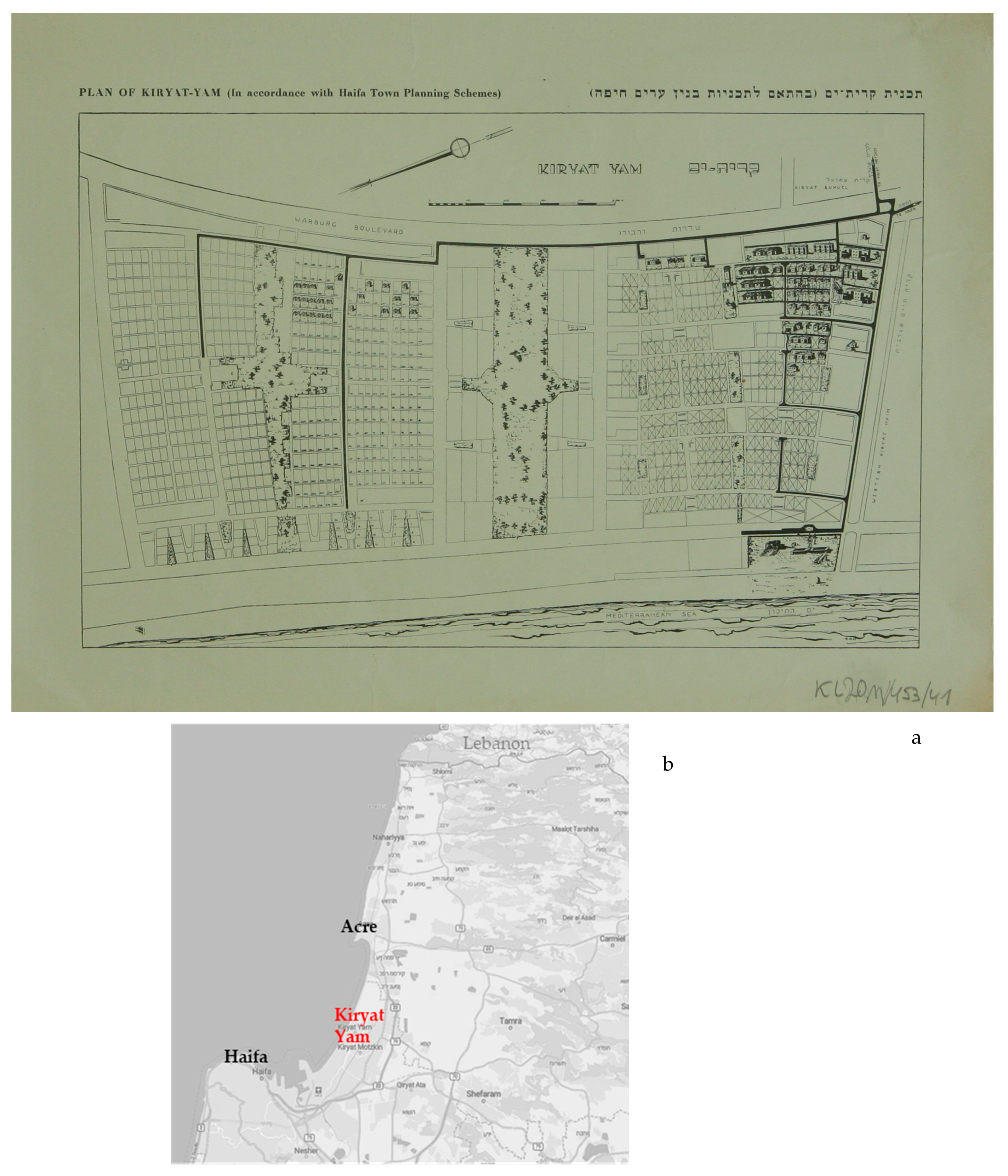
Kiryat Yam is located in the northern part of Israel, between Haifa, the capital of the northern metropolitan area of Israel, and Acre (
Figure 1b), which are both old cities situated along the Mediterranean coast and located at both ends of the same bay. Acre is one of the oldest port cities in the world, with its maritime history dating back to the Early Bronze Age. Modern Haifa was founded in the mid-18th century and, starting from the 19th century, developed significantly and left Acre behind. Kiryat Yam serves as the northernmost city in the sequence of medium-sized cities between Haifa and Acre.
Kiryat Yam was planned before Israeli statehood. The land was bought in 1928 by the Jewish National Fund and the East Palestine Corporation [
33]. The plan for the new town, 2.5 km long and 1.5 km wide, was drawn by Alexander Klein. Born in Odessa, Klein fled the Russian Revolution and relocated to Berlin in 1920 [
34]. There, he developed his small apartment concept—an apartment with no hall and a clear separation between public and private spaces. Finalized after a study of domestic behavior [
35], the small apartment embodied his architectural doctrine: planning must be rational and informed by research, in the spirit of modernism.
Based on this rationale, and Klein’s European concept of a street hierarchy, the workers’ town of Kiryat Yam was planned with a clear separation between housing and leisure uses, with a rational traffic system based on five major avenues leading to the sea, perpendicular to streets and alleys running parallel to the sea. In addition, housing areas were divided equally, including a small patch of land for each housing unit that could also be used for growing vegetables for home consumption. This was influenced by the Zionist ideology, which sought to attach the Jews immigrating to Palestine to the land, as well as increase equality in the spirit of socialism [
36,
37] (see
Figure 1).
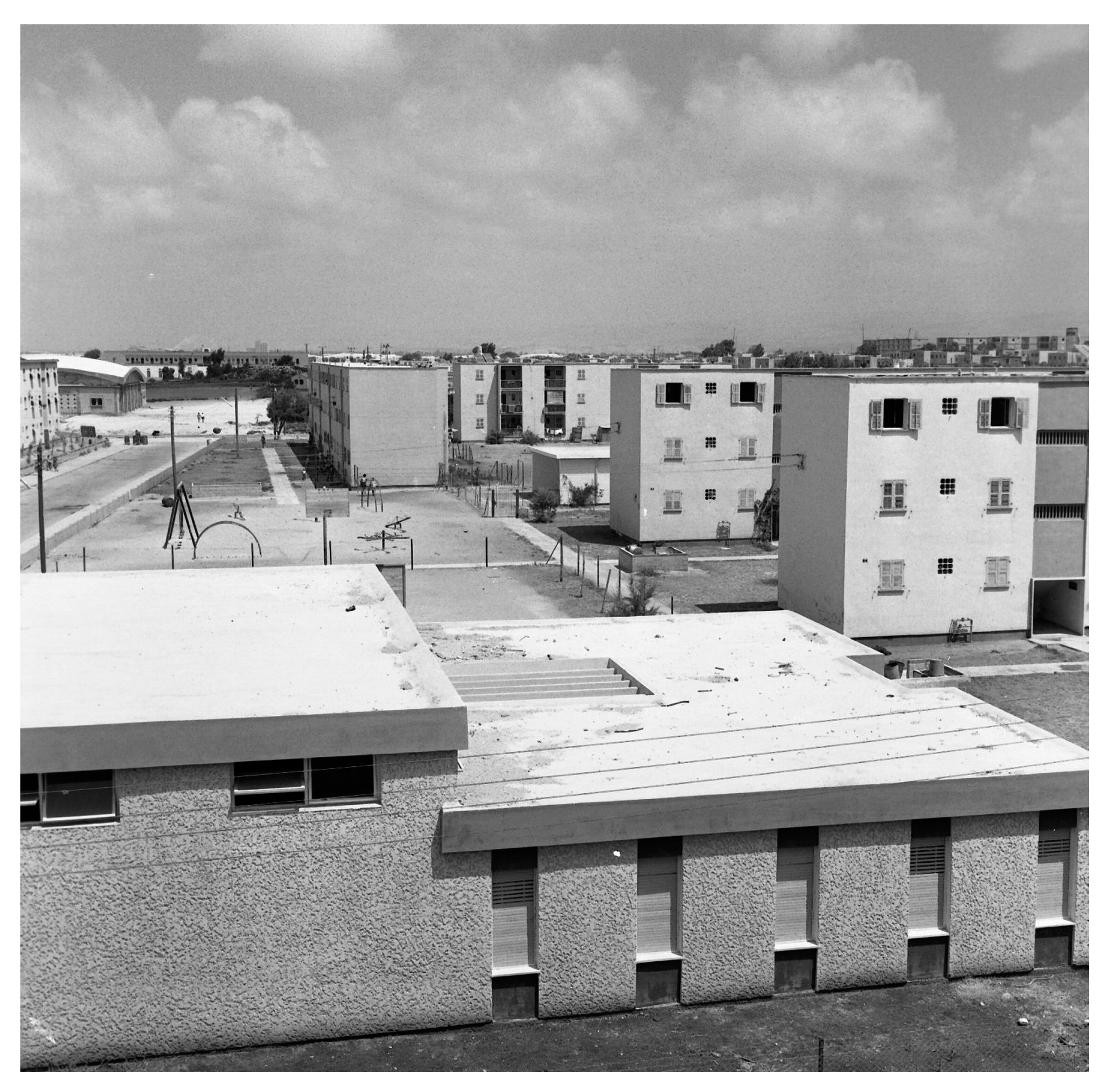
Construction began in 1941 but included only a few houses. It was resumed in earnest after Israel became independent in 1948 [
33], when Kiryat Yam was built by the state’s Department of Public Housing, which would become the Ministry of Construction. In order to house the new immigrant Jews, who tripled Israel’s population during its first decade, some of the houses were built not according to the original plan. The identical multi-story buildings were located according to the modernist city building approach, according to Gropius’s Zeilenbau or La Corbusier’s open plan, facing open areas. Consequently, there was no need for streets and alleys, since walking in this area was supposed to be unimpeded (see
Figure 2 and
Figure 3).
Given that the modernist nature of the neighborhood represents public housing and many neighborhoods throughout Europe [
39], we found it appropriate to focus the article on this urban fabric.
3. Results: Analysis of the Built Environment—The Community and Spatial Perspectives
3.1. Sense of Community
Kiryat Yam’s population has remained stagnant since 1995, with 39,000 residents. Despite the years-long emigration from the town, many of its longtime inhabitants are not interested in leaving. According to the Central Bureau of Statistics (2020) [
39], its socioeconomic rating is five out of ten.
Approximately 26% of the population consists of seniors (14% national average), around 21% are children up to the age of 18 (33% national average), and 53% fall into the working-age category (similar to the overall country’s percentage). This demographic distribution indicates that the city is predominantly aging. The majority of workers are in a salaried position, with an average salary that is 20% lower than the national average. About 40% of salaried workers earn the minimum wage accepted in Israel, which is 20% lower than the country’s average wage. One prominent characteristic of the city is its role as an absorption center, resulting in a diverse population, including people from different origins. Since 1990, 36.5% of the total population are immigrants. Approximately 87% of residents work outside the city, with a notably high daily commuting rate. About 47% of residents commute to work by private car, while there is a significant use of public transportation for commuting to work (Central Bureau of Statistics 2020 [
40]).
In March 2020, as part of a city planning studio for graduate students at the Technion—Israel Institute of Technology, we conducted interviews with 95 town dwellers of all neighborhoods, aged 16–73. About 40% had lived in Kiryat Yam for 20–30 years, and the others had lived there for over 30 years [
16].
The survey produced three main findings. First, many interviewees were not satisfied with the services in town. About 40% stated they were not satisfied with the educational and sports services. Many pointed to the need to improve the town’s visibility and public transportation. Many others complained about the lack of workplaces, forcing many locals to commute. Still others complained about the lack of leisure and commercial centers. One participant wrote that “there’s nothing apart for a café”.
Second, there were diverse and active social groups in town. These included youth movements, community and family groups (parental patrol, community centers), groups assisting new immigrants and senior citizens, various welfare centers (soup kitchens, occupational/financial assistance) and various community-based media groups.
Third, despite these weaknesses, the residents liked their town and community and were not interested in leaving. About 75% felt safe in town, and 51% liked being close to the sea and being able to access it with ease. Note that Kiryat Yam is exceptional in this regard, as towns adjacent to the sea are usually more expensive and attractive. Finally, 75% expressed their desire to remain in Kiryat Yam, stating that it was quiet, compact, and communal.
The data from the Central Bureau of Statistics (2020) [
40] and the analysis of interviews indicate that despite a low level of satisfaction with the current situation in Kiryat Yam and the public services the city offers, a significant majority of residents choose to stay in the city. They rely on additional qualities that the city possesses despite the data, such as tranquility, a sense of security, proximity to the coastline, and more. We see these aspects as a future strength and a bright spot for the city, countering the negative aspects of the deteriorated existing apartments and buildings. As we move forward with urban renewal and redevelopment, it is crucial to rely on these aspects while maintaining the existing community cohesion and strength in the city.
3.2. Analysis of the Quality of the Built Environment
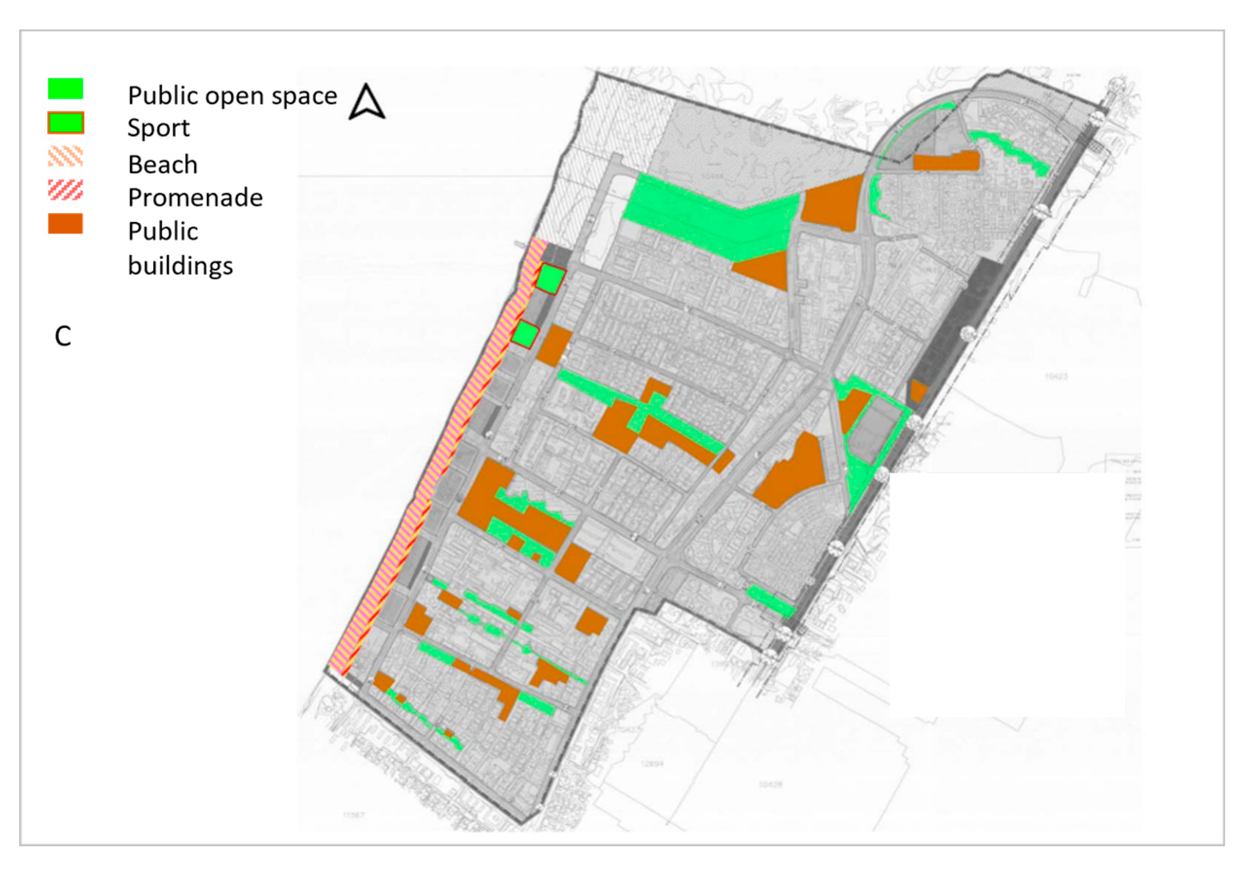
As mentioned, the urban road grid is based on five main avenues leading to the sea. These avenues divide the town into neighborhoods and districts, which in turn are subdivided by streets running perpendicular to the avenues and secondary streets running parallel to them.
The following describes the analysis of the quality of the built environment in terms of the four main characteristics: walkability and connectivity, public open areas, diversity and land uses, and visibility towards the inner and outer views.
Walkability and Connectivity:
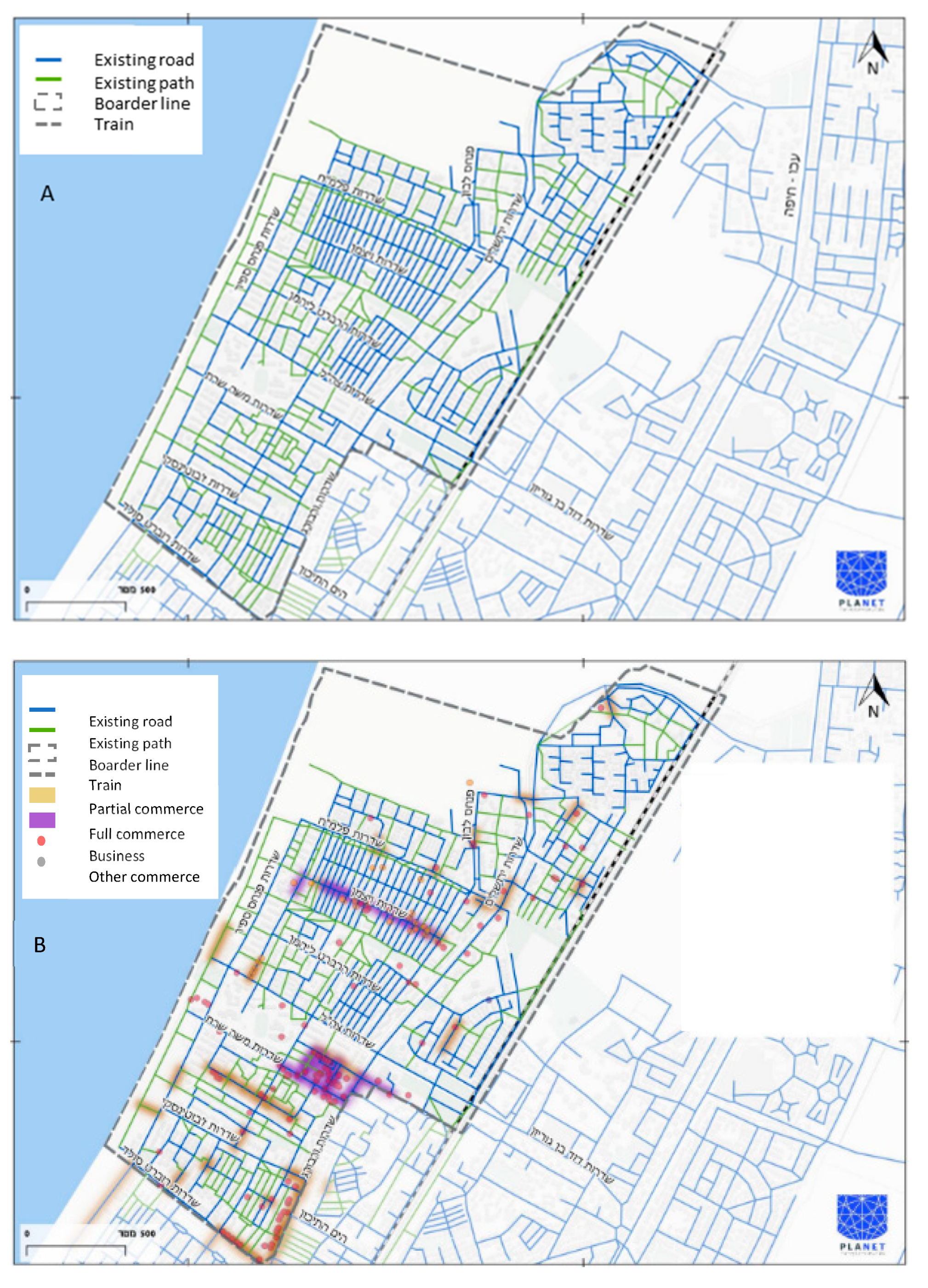
The existing urban grid shown in
Figure 4 is based on streets and paths connecting the various areas of the city. It contributes to strengthening Kiryat Yam’s longtime community. The public open space of the neighborhood is already accessible and adapted to the needs of this population. The residents “own” it, functionally speaking, feel safe in it and consider it a continuation of their domestic uses. The road system is highly dense, with high accessibility; it is well-ordered and walkable, and suitable for all ages [
41]. In fact, this is a grid city in the most basic sense. For example, the distances between the inner roads are 50–100 m—highly walkable. Between the large urban blocks, we find distances of 200–300 m—also highly walkable. Because of the sparse construction within and between the neighborhood, both internal neighborhood views and outer urban views of the avenues, and from there to the sea, are highly visible, with the latter in particular being significant for the residents.
Diversity and Urban Usages:
Our analysis of the current situation indicates that the public and commercial areas are planned sparsely and disjointedly, without diversity, and with little in the way of capitalizing on the grid to create a continuous system with connectivity across the various areas along the main avenues. To the extent that there are commercial hubs, they are highly localized, not distributed across the town, and disconnected, thereby failing to optimize the town’s potential (see
Figure 4). As we have seen, the interviews indicate that there is much to be improved in commercial, cultural, occupational, and public buildings to sustain a diverse, high-quality, and bustling town. For culture, employment, and commerce, the residents of Kiryat Yam have to commute to neighboring cities.
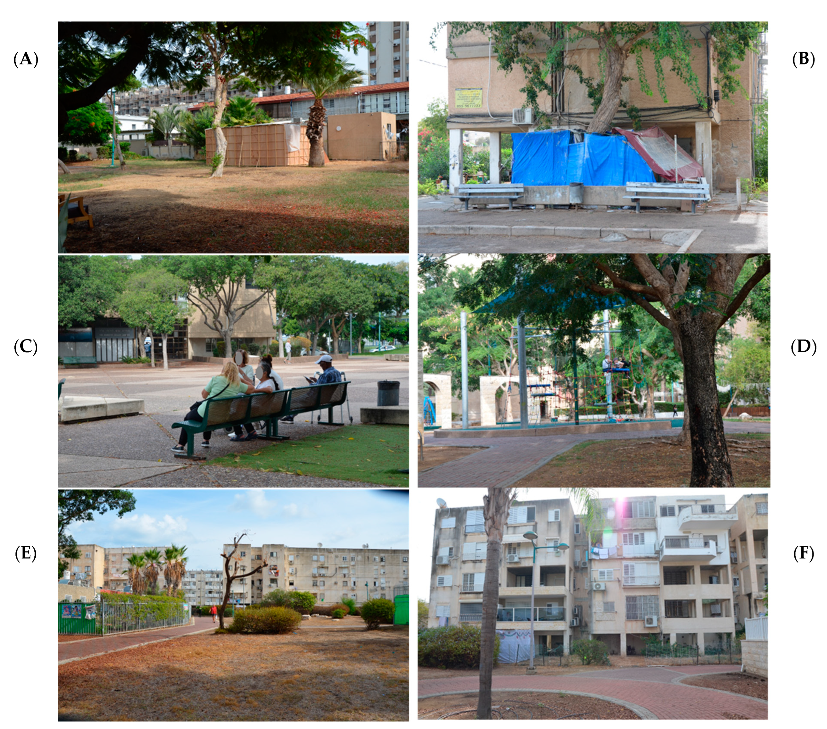
Open Public Areas:
Kiryat Yam was planned disjointedly, without connectivity between the various areas along the main traffic routes (see
Figure 4). However, a tour of the neighborhood indicated a wide variety of open public areas between the buildings, and their diverse uses (see
Figure 5).
A modernist urban fabric combined with public housing fabric has resulted in a hierarchy-free urban fabric characterized by relatively low-rise buildings (most reaching no higher than four floors) and vast, undefined open spaces. Both the low height and fabric facilitate the connection between interior spaces and external spaces, particularly as the buildings and public open spaces evolve over time. This combination facilitates the development of a sense of ownership towards the various public spaces. Planned urban activities, along with initiatives from the residents, have created pleasant open spaces defined by natural elements that well serve the community’s needs, as illustrated in
Figure 5.
These areas vary in size, enabling group gatherings of different sizes. Some are small, with chairs, eating areas, play areas and gardens. They are connected by local paths, enabling high connectivity and walkability between the residential areas. A tour in the Jewish holiday of Sukkot (held in October 2023) by the authors demonstrated how these areas could be used to build the communal temporary huts where the holiday is celebrated (see
Figure 5A). In different terms, these spaces, fruits of modernist neighborhood planning, serve as meeting points for the old community.
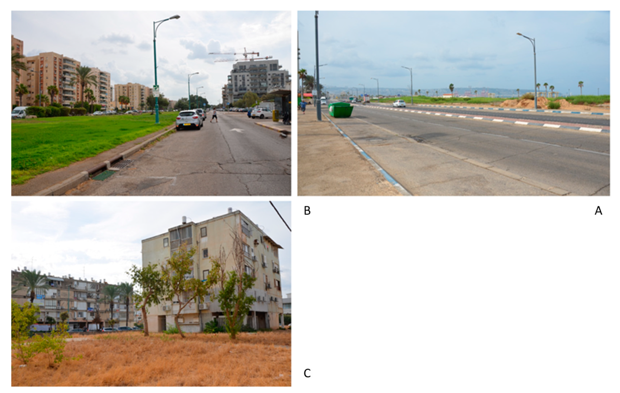
Visibility to the Open Views:
Access to the open views, whether internal or external, is Kiryat Yam’s forte. With regard to internal, urban views, the houses look out to the open neighborhood areas, some of which have been developed by the municipality or residents (see
Figure 5A–D), and some of which are neglected (
Figure 6C). The broad and empty avenues represent another type of open vista, and the sea is obviously an important asset in that regard (see
Figure 6).
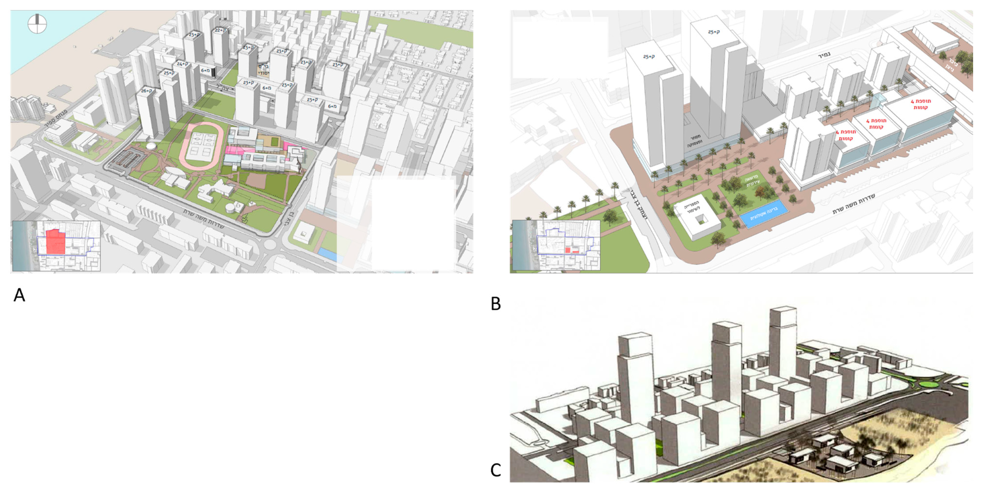
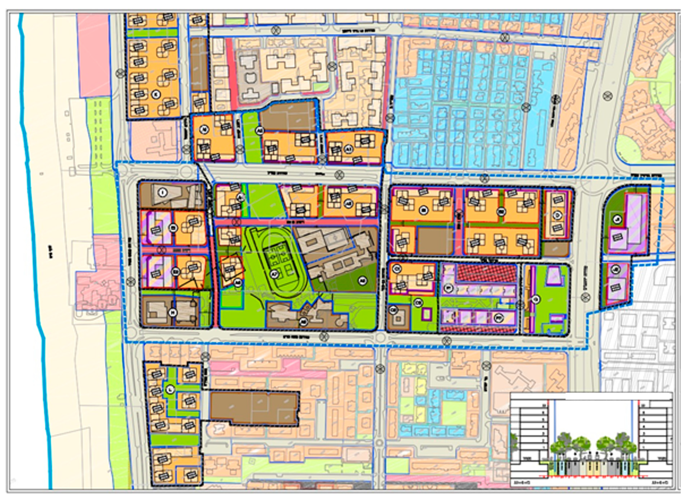
3.3. The Urban Renewal Plan
Over the years, the buildings erected in the 1950s and 1960s, populated by low-income new immigrants, became aged and deteriorated. Urban renewal plans such as the Comprehensive Urban Outline Plan [
40] have sought to demolish the low and sparse constructions in favor of nine-story buildings and high-risers, in order to increase the existing population four- or even five-fold, thus ensuring profit for the private entrepreneurs. Although the guidelines for the comprehensive plan of Kiryat Yam include upgrading the existing street network and prioritizing pedestrians, bicycles and public transportation (in that order), the plan does not address the longtime residents’ needs, nor Kiryat Yam’s nature as a grid city.
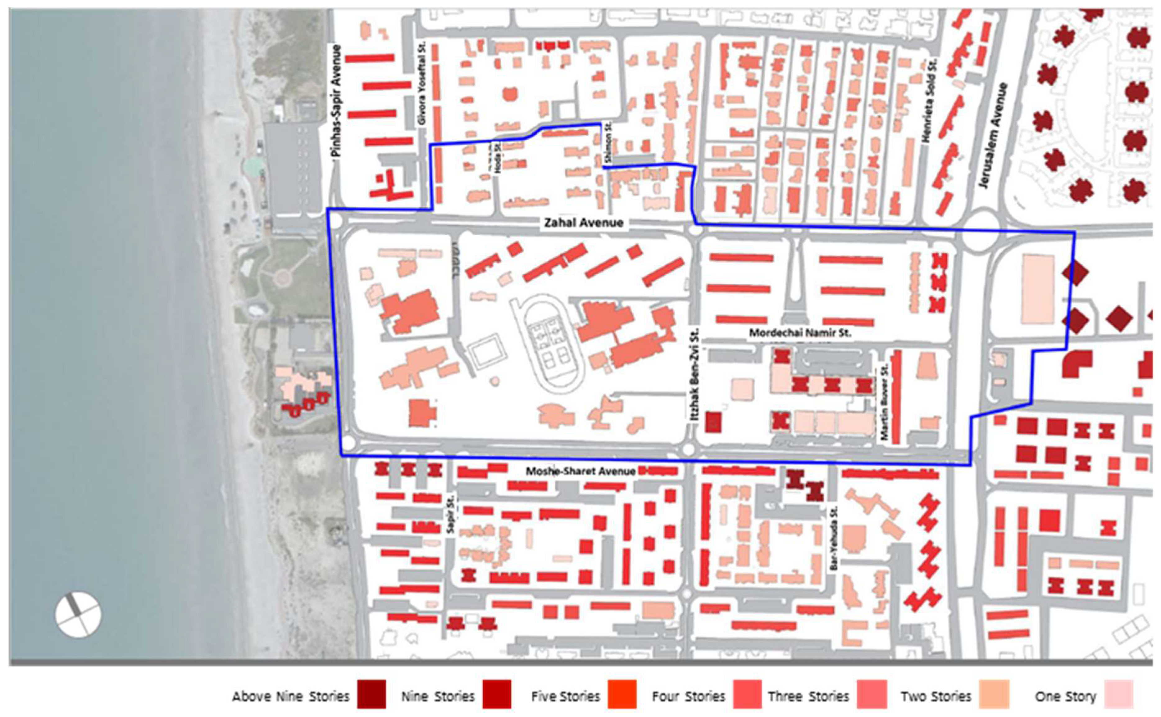
Thus, in the detailed masterplan for the urban center (originally planned as a park), derived from the comprehensive plan, only high-risers are planned [
38] (see
Figure 7). Such construction is unsuitable for a low-income population unable to afford the upkeep. Therefore, either the buildings will be neglected and abandoned by the high-income population, or the low-income population will be unable to afford to live in their own city, and it will be gentrified [
42].
The plan for developing the Cooperative Bloc [
43]—an area of public housing from the 1950s at the center of town—suggests that this plan does promote walkability by expanding walking areas (to 87% compared to 62%) as well as the shaded areas (to 41% from 3.5% (see
Figure 8)). However, this plan does not promote Kiryat Yam’s general renewal and does not change its open public spaces in any significant way, because it does not connect its various parts beyond the specifics detailed in the plan. It concentrates various uses into a single hub, thereby contributing little to strengthening the urban grid. Moreover, it does not connect to the network of public open spaces, nor open up new vistas.
To conclude, Kiryat Yam’s current sources of community resilience [
16] have not been taken into consideration in the renewal plans, which propose complete destruction of the old spaces and buildings. The landscape and community values of the inner-neighborhood open spaces have been neglected as well. Most critically, the urban spatial qualities have been ignored; the walkable grid that enables a distribution of diverse uses, mainly along the avenues. Moreover, the broad avenues offer significant space for additional construction that has not been taken into consideration. Thus, the old urban fabric has been erased, the city has been divided into functional areas (according to the zoning approach), and the planned high-risers are situated in space without regard to the current grid.
3.4. Proposed Urban Renewal Plan
3.4.1. Four Principles
To sustain the existing community and its inner-neighborhood open spaces, and assuming that the conditions detailed in the current study section obtain in Kiryat Yam, our proposal for urban renewal is four pronged.
Walkability and accessibility must be reinforced to serve both the longtime and the new community. The overall approach to urban development must return to the “old–new” concept (the urban DNA) of Kiryat Yam: high accessibility and five main avenues leading to the sea. This basic concept naturally promotes urban walkability.
Inner-neighborhood areas must be further developed for the longtime residents by cultivation, improved access, and adding a variety of uses; this is based on the understanding that these spaces constitute the ‘home’ of the old community, serving its existing and ongoing of functions in the area.
The five avenues need to be complemented with open public areas throughout (
Figure 6). At present, the plan is for a network of bicycle routes along the avenues. Combined with them, continuous open public spaces connecting the main avenues and public areas between the residential buildings in the old neighborhoods will contribute immensely to the city’s public areas.
The views to the open areas must be used to construct the edges of the avenues, add varied uses, strengthen the connection to the sea, and strengthen and enhance the dominance of the inner-neighborhood open areas.
3.4.2. Three Actions
To achieve all these aims, three main actions must be taken, as follows:
Strengthening the old buildings and open spaces within the neighborhoods for the longtime residents. This includes adding varied uses and renovating the old buildings through the densification mechanism detailed in the introduction. This would maintain the existing community’s resilience.
New construction of the edges of the existing neighborhoods along the five main avenues, adding uses currently lacking in Kiryat Yam. We propose diverse residential construction suitable for the middle–high and creative classes [
20], who will drive the urban renewal and economy, coupled with workplaces, commercial areas and public services for all populations. Locating the new populations and uses at the edges of the avenues would direct the former to a distinctly urban space, thereby preventing their forced integration into old and unsuitable peripheral spaces. This action will contribute to the resilience of the entire city by boosting the economy, increasing physical and human diversity, and providing additional services to the entire population (see
Figure 9).
Connecting the two networks. Continuous open areas need to be planned to connect the avenues and open public areas between the buildings of the old neighborhood, combined with the bicycle route network. Such connectivity will contribute to Kiryat Yam’s open public spaces and to urban resilience overall through walkability, accessibility, and connectivity.
4. Discussion and Conclusions
Most studies on urban renewal do not address the physical aspects but rather focus on legal [
44], economic [
12], and social [
43] dimensions. This article contributes to the limited research that explores the spatial dimension [
45]. By analyzing conventional solutions, we propose an innovative spatial solution that is unique and innovative.
This article indicates that the solutions for urban renewal based on the infusion of new populations into aging or neglected neighborhoods are based on building new neighborhoods instead of those demolished. Since we are dealing with the geographical periphery, one of whose strengths is the community resilience already established in the old neighborhoods, we asked how this can be done without damaging the longtime residents’ community resilience.
The logic behind our approach combines the needs of the city with the needs of the community. Given that the urban population is socioeconomically disadvantaged, the city has a significant interest in attracting a new population, serving as a kind of social and general rejuvenation for the city. On the other hand, in the old neighborhood, a cohesive community has formed that needs to be preserved. Moreover, the physical structure of the neighborhood, based on modernist low-rise buildings and diverse open spaces, provides numerous meeting places for the community. Hence, the proposed solution is derived; preserving the physical spaces of the old community, alongside new and extensive development for the benefit of a strong and new population that will propel the city forward.
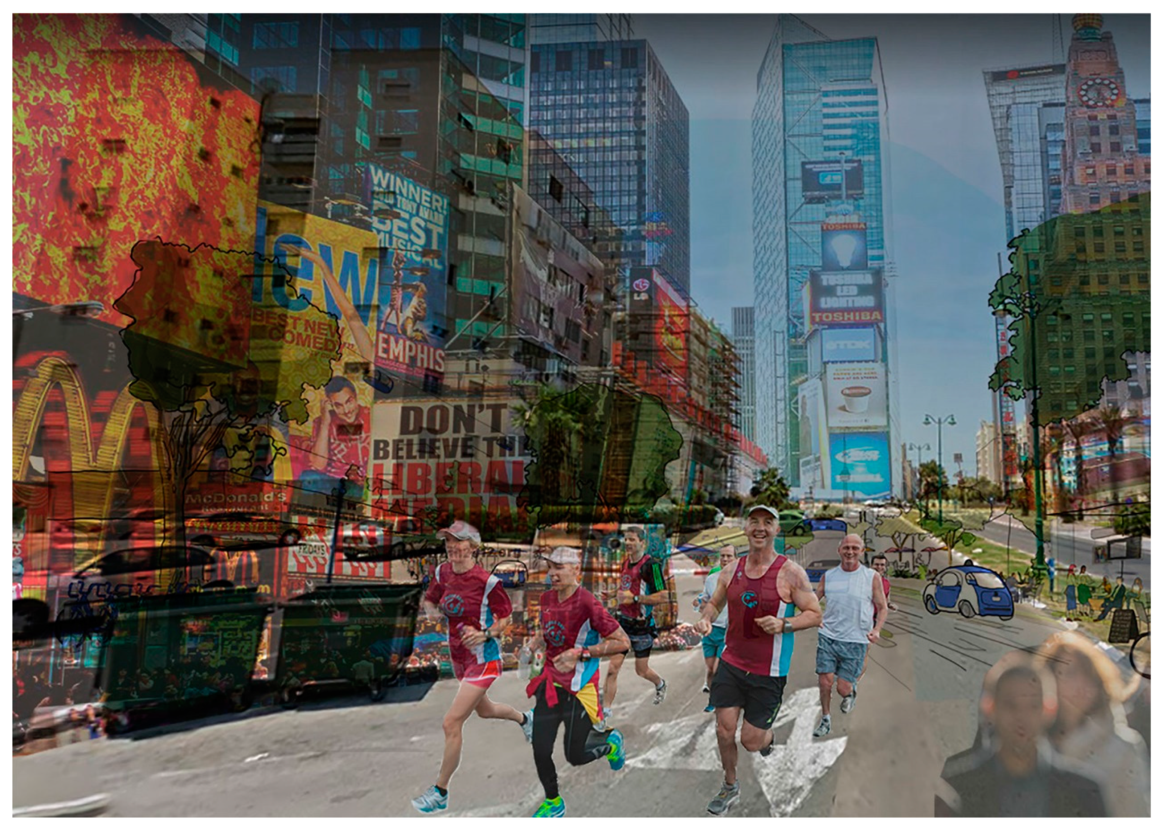
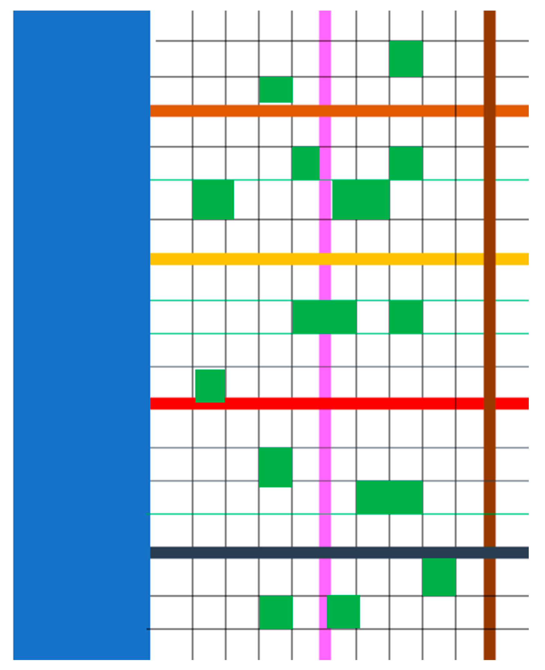
The solution offered here may be captured in the term ‘additional spatial network’ (see
Figure 10)—an additional network of housing and commercial, occupational, and other uses at the edges of the neighborhood. The new construction should face the five main roads dividing the city. Since these are two wide and too empty to begin with—the outcome of modernist planning that has prioritized transportation efficiency—this would also be an opportunity to narrow them and turn them from motorways into residential streets enabling pedestrian and bicycle traffic. When the city’s walkability potential is high, and when the passage grid enables connectivity, this is a win–win solution: the old neighborhoods retain their community structure, and the new construction creates a new, street-oriented and vital urban system.
This solution offers multiple benefits. First, it outlines a way of solving the problems of urban renewal in the periphery [
43]. Urban renewal in peripheral areas faces many obstacles, but more than that, it appears that the blocking point for promoting these processes is not clear. Our study suggests that longtime communities are attached to the place and are generally not interested in relocating, particularly because of their strong community and resilience. We argue that strengthening the local community, while enhancing the qualities of its living space that are appropriate for community living, will ensure the success of urban renewal in the periphery and contribute to overall urban resilience.
Second, new populations may contribute to the renewal of peripheral cities by developing new urban areas instead of vacant urban spaces, to create vital and functionally diverse streets. This way, both the creative and the middle–high classes will not feel forced to live in an old neighborhood characterized by neglected public housing blocks.
Third, by leaving old communities in their homes and surroundings, displacement and gentrification, which often occur in peripheral towns, can be prevented.
Fourth, leaving elderly populations in their place is essential for their sense of well-being, which is greatly affected by environmental changes.
Fifth, the remaining supply of low-cost apartments can also serve other demographic groups in various stages of their lifecycle, such as young couples, single and divorced people, and senior citizens.
Sixth, enhancing urban diversity in given areas by diversifying their inhabitants and the housing and public area patterns will contribute to the town’s flexibility and, consequently, its community and urban resilience.
Finally, the proposed solution pays respect to the city’s structural heritage, which is not destroyed to pave the way for the latest construction fashion (which is mostly more profitable for the entrepreneur).
In conclusion, urban renewal in peripheral cities faces many human, structural, and economic obstacles. Relying on the resilience of the old population of the city and the spatial urban network that exists in it can promote urban renewal for the old population and integrate a new one. In any peripheral urban renewal, it is important to understand that urban networks vary from city to city, and the existing population as well as the existing urban network must be considered. Note, however, that this solution does not detract from the need to address specific issues related to the old construction, particularly in public spaces and all the more so in areas with weaker communities. The municipality is responsible for maintaining public areas, as well as for providing low-cost loans and professional assistance to those wishing to renovate their houses and adapt them to their needs.


