Article

An Insight into Underground Hydrogen Storage in Italy

1
National Institute of Oceanography and Applied Geophysics—OGS, Borgo Grotta Gigante 42/C, 34010 Sgonico, Italy
2
Geostock, 2 Rue des Martinets, 92500 Rueil-Malmaison, France
*
Author to whom correspondence should be addressed.
Sustainability 2023, 15(8), 6886; https://doi.org/10.3390/su15086886
Submission received: 17 March 2023 / Revised: 12 April 2023 / Accepted: 16 April 2023 / Published: 19 April 2023
(This article belongs to the Special Issue Energy Transition and Hydrogen: Challenges and Opportunities)

Abstract

:
Hydrogen is a key energy carrier that could play a crucial role in the transition to a low-carbon economy. Hydrogen-related technologies are considered flexible solutions to support the large-scale implementation of intermittent energy supply from renewable sources by using renewable energy to generate green hydrogen during periods of low demand. Therefore, a short-term increase in demand for hydrogen as an energy carrier and an increase in hydrogen production are expected to drive demand for large-scale storage facilities to ensure continuous availability. Owing to the large potential available storage space, underground hydrogen storage offers a viable solution for the long-term storage of large amounts of energy. This study presents the results of a survey of potential underground hydrogen storage sites in Italy, carried out within the H2020 EU Hystories “Hydrogen Storage In European Subsurface” project. The objective of this work was to clarify the feasibility of the implementation of large-scale storage of green hydrogen in depleted hydrocarbon fields and saline aquifers. By analysing publicly available data, mainly well stratigraphy and logs, we were able to identify onshore and offshore storage sites in Italy. The hydrogen storage capacity in depleted gas fields currently used for natural gas storage was estimated to be around 69.2 TWh.

1. Introduction

The European Union and the Intergovernmental Panel on Climate Change [1] have set a target of limiting global warming to 1.5 °C by 2050, as stated in the Paris Agreement (Conference of the Parties COP21) and the European Green Deal [2]. Against this backdrop, hydrogen-related technologies have steadily gained interest from both industry and academia owing to their versatile role in low-carbon energy ([3] and references therein). As a substitute for carbon-based energy, the demand for low-carbon hydrogen is steadily increasing [4,5,6]. Owing to its chemical properties, hydrogen is rarely present in nature as a single element (pure H2); there is a natural hydrogen reservoir in Mali [7] and some hydrogen deposits in cratons and along ocean ridges [8]. Therefore, hydrogen must be extracted from the molecule in which it naturally occurs (usually water or hydrocarbons) and stored in its pure form to be used for energy processes.
Depending on the production process, different colours are assigned to hydrogen, with grey, blue and green being the most common. Grey hydrogen, which is currently the most commonly used, is produced from natural gas, producing carbon dioxide (CO2) as a by-product, which is released into the atmosphere. According to the World Energy Council (2019) [9], 96% of the hydrogen produced is grey hydrogen. When the CO2 produced is captured and stored underground (e.g., through Carbon Capture and Storage-CCS), the hydrogen is referred to as blue. Green hydrogen, also referred to as “clean hydrogen”, is produced by electrolysis of water by splitting it into hydrogen and oxygen (O) from renewable electricity sources, making it a highly beneficial option in terms of clean energy [4,10]. Green hydrogen accounts for about 0.1% of total hydrogen production, but this share is expected to increase in the near future as costs decrease and renewable energy becomes more widespread [11]. However, the production of green hydrogen is still very expensive owing to the high cost of electrolysers and the currently insufficient surplus capacity of renewable energy to meet the large demand for hydrogen.
One of the main issues faced by renewable energy operators is the intermittent nature of production, leading to energy surpluses or deficits, and geographical constraints [4]. One of the ways to compensate for this energy gap is to convert surplus energy into hydrogen that can be readily stored and made available on demand [12,13,14]. Pipelines or tanks commonly used for surface storage can only meet hydrogen demand for hours or days [15]. Underground hydrogen storage (UHS) is attracting increasing interest as it enables the provision of sufficient storage capacity to contain potentially large quantities of hydrogen [4,16]. Salt caverns, saline aquifers and depleted hydrocarbon fields are geological media characterised by large volumes, thus offering potential storage for large quantities of hydrogen, mainly through structural/stratigraphic trapping mechanisms. As with underground storage of natural gas, i.e., methane, it must be possible to extract sufficiently pure hydrogen from the store in order to be useful for power generation. In addition, the geological media being considered for UHS must have properties suitable for the storage of H2 molecules. Hydrogen is a very small molecule and is highly reactive with biological and chemical components. Moreover, H2 has a very low density (for example, it is eight times less dense than CH4 and 22 times less dense than CO2) [17]. Thus the overburden layer must have a very low permeability to minimise H2 dispersion. Storage of H2 will require larger reservoirs and potentially higher pressures to store the same volume of H2 compared with CH4 and CO2. The biological and geochemical reactions that can occur in a reservoir are also an important aspect to consider, as reactions can consume H2, thereby reducing the amount of H2 that can be retrieved [4,14,18,19]
There are examples where hydrogen is stored in salt caverns, usually as a component of a gas mixture, with methane forming the larger portion [20,21,22,23]. However, although salt caverns are considered most favourable for UHS due to their physical, chemical, economic and mechanical properties, which allow secure and efficient storage even at high pressure [22], salt deposits of suitable quality are not evenly distributed worldwide. There has been H2 storage in three caverns in Teesside, UK, since 1977 and in the US since 1983 ([3,24,25] and references therein). A review of the feedback from the operation of the six salt caverns that have been used for hydrogen storage, and of the recent technical developments related to pure hydrogen storage in salt caverns, can be found in [26].
Other geological media potentially suitable for UHS include aquifers [4,27,28,29] and depleted hydrocarbon fields [4,10,14,15,16,30]. Aquifers are porous and permeable media in which the pore space is filled with fresh or salt water. The first tests of UHS in these geological media have been carried out in France (Beynes), the Czech Republic (Lobodice) and Germany (Engelbostel, Bad Lauchstädt), through the storage of town gas, i.e., gas obtained by the gasification of coal, which has a hydrogen content of about 50–60%. Marcogaz (2017) [31] lists seven sites, both depleted gas fields and aquifers now decommissioned or used for natural gas storage, that stored such town gas.
However, several concerns have been raised about UHS in porous geological media, mainly related to changes in the composition of the stored gas due to biogeochemical reactions between the injected fluids and the storage complex [19,30,32,33,34,35,36]. These reactions could affect both the petrophysical properties of the reservoir and of the caprock, e.g., the caprock porosity can be increased by the chemical dissolution of the clay minerals, and the conversion of H2 to H2S, formate and methane owing to microbial activity, even after less than three months after H2 injection, reducing the available H2 volume [19,37]. Another issue is related to the extraction phase, when a release of water into the environment can occur [16,27,38].
Depleted hydrocarbon reservoirs, and depleted gas fields in particular, offer a strong opportunity for large-scale UHS owing to their known geological structure, the presence of surface and subsurface facilities and, most importantly, their proven gas containment over geological time.
A recent review by [10] highlights both pros and cons of hydrogen storage in such a geological media. In the first instance, site-specific analyses and fluid-dynamic, geochemical and geomechanical modelling need to be performed in depleted hydrocarbon reservoirs chosen for being converted into hydrogen reservoirs, since the gas/oil still in place could react with the injected hydrogen-producing methane [36,39]. Avoiding hydrogen loss is the main challenge UHS in depleted hydrocarbon fields is facing. It can occur through various mechanisms, which rely on different H2 properties, e.g., density, viscosity, diffusivity and solubility strongly influence hydrodynamics, whereas geochemical and microbial effects are mostly related to the petrophysical properties of the storage complex.
H2 losses through different kinds of mechanisms, such as diffusivity, fingering and gravity segregation, together with micro-bio-geochemical reactions within the reservoir, are the major challenges UHS in depleted hydrocarbon fields is facing. However, these media appear to be the most viable option from the economical point of view: compared to aquifers, site characterization costs can be strongly abated or even absent here, because the storage complex characteristics are already known, thus reducing the total capital costs [40].
Well integrity plays a crucial role in all the geological media suitable for UHS, especially concerning the quality of hydrogen during the withdrawal phases. One of the factors that can strongly affect well integrity is H2 embrittlement or hydrogen-assisted cracking, which mostly occurs in steel and consists of a reduction in the ductility of a metal due to absorbed hydrogen ([10] and references therein).
There is a recent experience of pilot injection of hydrogen gas blends in porous reservoirs. As part of the Sun-Storage Project, a mixture of 10% hydrogen and natural gas blend has been injected in a small isolated depleted gas field in Lehen, Austria [41]. In the Underground Sun Conversion follow-up project, batch injections of 10% or 20% hydrogen and 2.5% CO2 and natural gas were carried out in the same Lehen field [36]. A plan for pure hydrogen injection in a porous reservoir has also been announced by RAG (Renewable and Gas) Austria, but no results are publicly available to date [42]. In Argentina, the HyChico pilot project also considered a hydrogen blend injection in a depleted gas field [43].
The increasing demand for hydrogen is driving in-depth studies of the possibilities for geological media to ensure secure long-term storage and to establish technical guidelines. The H2020 FCH-02-5-2020 Hystories project (Underground storage of renewable hydrogen in depleted gas fields and other geological stores—https://hystories.eu [44], accessed on 16 March 2023) was launched in this context, aiming to identify and characterise potentially suitable sites for the storage of green hydrogen in European aquifers and depleted hydrocarbon fields, and to define the technical and economic feasibility of storage. The project involved 19 countries in Europe, drawing together universities, research institutes and natural gas storage companies. The National Institute of Oceanography and Applied Geophysics—OGS was involved in assessing the potential of hydrogen storage in the Italian subsurface.
In this study, carried out in the framework of the EU Hystories project, we provide the first national assessment of the suitability of the Italian subsurface for Underground Hydrogen Storage (UHS) from a geological and stratigraphic point of view, i.e., the first fundamental step for all future targeted projects. Through the Hystories project, the first maps of sites potentially suitable for UHS both onshore and offshore in aquifer formations and in depleted hydrocarbon fields. In this paper, we also provide a first estimate of hydrogen storage capacity.

2. Materials and Methods

The first objective of the EU Hystories project was to identify potential opportunities for underground pure hydrogen storage (UHS) in European saline aquifers and depleted hydrocarbon fields (Table 1). For this purpose, a unified database was populated with the latest publicly available information on regions and sites that might be suitable, from a geological point of view, for the development of hydrogen storage.
Table 1. Potential UHS reservoirs subdivided by type and location.
Reservoir TypeQuantityOnshoreOffshore
Shallow aquifers
(500–800 m) 1
13112
Deep Carbonate aquifers
(>800 m) 1
14113
Deep Terrigenous aquifers
(>800 m) 1
14113
Depleted hydrocarbon fields25250
Total66588
1 For details about Deep Carbonate aquifers, see [45]. For details about Deep Terrigenous aquifers, see [46]. Information concerning shallow aquifers is provided in Table 2. Details about depleted hydrocarbon fields are provided in Table 3.
Table 2. Main parameters of potential reservoirs for H2 storage in shallow aquifers and associated caprock.
ReservoirReservoir Stratigraphic UnitReservoir LithologyReservoir Thickness (m)Top Reservoir Depth (m)Area (km2)Caprock LithologyMinimum Caprock ThicknessCaprock Stratigraphic Unit
Abruzzi 1 SHALLOWNeogeneConglomerate with sand intercalations65–16758524Marly clay97Neogene
Emilia 1 SHALLOW-1NeogeneSand with clayey levels102–3635805Clay172Neogene
Emilia 1 SHALLOW-2NeogeneSand with clayey levels (Porto Corsini Fm.)2004906Santerno clay35Neogene
Lombardia 2 SHALLOWNeogeneSergnano gravel77–216715226Marly clay75Neogene
Marche 1 SHALLOWNeogeneAlternance of sand, quartz sand and clayey sand40–7650935Clay122Neogene
Molise 2 SHALLOW-1NeogeneSand with clay intercalations55–1997107Clay24Upper Pliocene
Molise 2 SHALLOW-2NeogeneAlternance of sand, quartz sand and clayey sand119–5756081Clay15Upper medium Pliocene
Molise SHALLOW-1QuaternarySand and gravel and sand with clay layers52–208605–67676Clay270Quaternary
Molise SHALLOW-2NeogeneSand and fine sand with clayey layers62–7465936Santerno clay38Neogene
Northern Bradanic Trough SHALLOWNeogeneSand and fine sand with clayey layers42–12858526Clay14Neogene
Sicily Channel SHALLOWNeogeneQuartz sand38–138450613Clay73Neogene
Southern Adriatic_SU SHALLOWNeogeneLimestone48–25254716Silty clay105Neogene
Southern Bradanic Trough SHALLOWQuaternarySand and conglomerate with clay layers48–25242477Clay100Pleistocene
Table 3. Main parameters of the potential reservoirs for H2 storage in depleted gas and/or oil fields and the related caprocks.
ReservoirReservoir Stratigraphic UnitReservoir LithologyRemarksReservoir Thickness (m)Reservoir Depth (m)Area (km2)Caprock LithologyCaprock Thickness
AlfonsineNeogeneSand (Porto Corsini Fm.)Depleted gas, presently used as natural gas storage150145085.88Clay and silt (Porto Garibaldi Fm.)110
Bagnolo MellaNeogeneGravel and sand with clay levelsDepleted gas, presently used as natural gas storage-116024.07Santerno clays Fm.-
BordolanoNeogeneSand and conglomerates (Caviaga sand Fm.)Depleted gas, presently used as natural gas storage-170062.97Santerno clays Fm.-
BrugherioLower PlioceneGravel and sandDepleted gas and oil field, presently used as natural gas storage-1050–110057.85Santerno clays Fm.300
CellinoPlioceneSandDepleted gas or hydrocarbon field, presently used as natural gas storage-110030.38 -
CollaltoNeogeneDolomitic sandDepleted gas, presently used as natural gas storage-150089clay100
CorneglianoNeogeneSand and conglomerates (Caviaga sand Fm.)Depleted gas, presently used as natural gas storage400130024.23Santerno clays179
CortemaggioreMessinianSand with silty-clayey levels (Cortemaggiore sans)Depleted gas or hydrocarbon field, presently used as natural gas storage-150081.61Santerno clays200
Cugno le MacinePlio-PleistoceneSand levels of the santerno clays Fm)Depleted gas or hydrocarbon field, presently used as natural gas storage-110048.16Santerno clays-
Filetto1-Emilia 2NeogeneSandDepleted hydrocarbon or gas field188125079.8Limestone-
Fiume TresteNeogeneSand and conglomerate sandDepleted gas or hydrocarbon field, presently used as natural gas storage-120076.79Allocton50
MinerbioNeogeneSand with clay levelsDepleted gas, presently used as natural gas storage300130068.61Santerno clays130
Pandino 1-Lombardia 2NeogeneSandDepleted hydrocarbon or gas field621–621140016clay-
Piadena est Depleted hydrocarbon or gas field--15 -
PoggiofioritoNeogeneCalcareous sandsDepleted gas field, request for natural gas storage50-10.18clay80
Ripalta stoccaggioNeogeneSand (Caviaga sand Fm.)Depleted gas or hydrocarbon field, presently used as natural gas storage-140062.96Santerno clays-
RomanengoNeogeneSand (Caviaga sand Fm.) and Gravel (Sergano Gravel)Depleted hydrocarbon or gas field12015006.5Santerno clays-
San Potito-CotignolaNeogeneSandDepleted gas or hydrocarbon field, presently used as natural gas storage-140052Santerno Clays70
SabbioncelloUpper-medium PlioceneSandDepleted gas or hydrocarbon field, presently used as natural gas storage-1100 Santerno clays75
San BenedettoNeogeneSand and clay sand (Carassai Fm.)Depleted hydrocarbon or gas field, request for Natural gas storage20–42255015Santerno clays171
SergnanoNeogeneGravel (Sergnano Gravel)Depleted gas or hydrocarbon field, presently used as natural gas storage-130042.31Santerno clays-
Serra PizzutaPlio-QuaternarySand (Santerno Fm.)Depleted hydrocarbon or gas field-1200113Santerno clays-
SettalaNeogeneSand (Santerno Fm.)Depleted gas, presently used as natural gas storage150115050.73 -
Sinarca stoccaggioNeogeneSandDepleted gas field, request for natural gas storage13–16-20.43clay8
TrevisoNeogeneSandGas field163–2891500372Sandonà marls287
Currently, there is no established procedure for screening or ranking aquifers or depleted oil or gas fields for their suitability for pure hydrogen storage. In principle, hydrogen storage in porous media is similar to natural gas storage, so the well-established industry of underground natural gas storage (UGS) offers important insights. Therefore, in the first phase of the Hystories project, a set of selection criteria for geological hydrogen stores was established, largely based on experience from natural gas and town gas storage in porous media. These criteria included depth to the top of the reservoir usually between 500 and 2500 m, net reservoir thickness of between 3 and 100 m, a minimum reservoir areal extent of 0.3 km2 and a maximum areal extent of 60 km2. These initial criteria are outlined in the Hystories report by Geostock [47]. Additional criteria were then added to take into account the specific properties of hydrogen. These additional criteria included the presence of minerals and fluids, which could enable geochemical or microbiological reactions, for example, CO2, sulphureous or iron-rich fluids.

2.1. Data Collection and Mapping

The Hystories database is built on primary basic reservoir data collected in two previous projects: Energy Storage Mapping and Planning (ESTMAP) [48] and CO2 Storage Potential in Europe (CO2StoP) [49], both on CCS. During Hystories, this dataset was significantly improved and extended by checking the previously collated data and adding new data according to the Hystories selection criteria for hydrogen storage. For Italy, newly available information on the terrigenous and carbonate saline aquifer formations from two related scientific publications [45,46] was added. Data on hydrocarbon fields released since the CO2StoP and ESTMAP projects were also reviewed and added to the Hystories database. Since shallower saline aquifers could potentially be used for UHS than are suitable for CO2 storage, well stratigraphy and well logs available in the national Italian database were analysed by OGS. This analysis identified saline aquifers at depths of 500–800 m (i.e., potential stores shallower than those identified through CO2StoP and ESTMAP) [45,46]. The national Italian dataset comprises 2305 well logs acquired since 1957 from several oil companies for on- and offshore hydrocarbon exploration and is provided by the Italian Ministry of Environment and Energy Security in the framework of the “Visibility of Petroleum Exploration Data in Italy (ViDEPI)” project [50]. The ViDEPI database (licence CC BY 3.0 IT) also contains approximately 55,000 km of multi-channel seismic lines collected from onshore and offshore hydrocarbon exploitation concessions.
These old data have been recovered from the raster files available in the ViDEPI database by OGS, which now makes them available according to internationally accepted standards on the web portal Seismic dataNetwork Access Point (SNAP) [51]. SNAP also contains other seismic datasets collected in other research projects and is fully interoperable with the main data exchange initiatives at the national and international levels (SeaDataNet [52], European Marine Observation and Data Network—EMODnet [53], National Antarctic Data Center—NADC [54] and similar).
The available well data comprises composite logs containing the following information: (1) lithology derived from cuttings; (2) geological formation name; (3) age of formation; (4) depth; (5) litho-stratigraphy; (6) presence of fluids; (7) depositional environment; (8) bio-stratigraphy; (9) geophysical logs (usually resistivity, spontaneous potential, sonic, gamma ray). In some cases, pressure and temperature values are also given. This information is available mainly for non-productive wells, while few data are publicly available for hydrocarbon-bearing boreholes. We did not use seismic data in our study (see Section 4. Discussion and Conclusions), thus the criteria we chose to define the areal extent of the shallow aquifer reservoirs were based on well log interpretation of lithology, thickness, depth and age. The same approach was used for the overlying caprock formations. The criteria used by OGS to identify potential storage opportunities for UHS was a minimum thickness of 50 m for the reservoirs and 30 m for caprocks, to provide sufficient potential storage volume and to ensure sealing capacity, respectively. To identify the presence of reservoirs in saline aquifers at depths of 500 m or more, at least two wells with comparable characteristics in terms of lithology, age, thickness and fluid contents were considered for each potential store. The list of these aquifers is shown in Table 2.
OGS reviewed data on depleted hydrocarbon fields in the Italian CO2StoP database and then populated the Hystories database with these data and newly available national data. The information on depleted hydrocarbon fields is publicly available on the website of the Ministry of Environment and Energy Security (https://unmig.mite.gov.it, accessed on 16 March 2023), as Italian regulations require oil companies to continuously submit technical reports to the Ministry on the activities carried out under their permits and concessions (Table 3). Although information on these geological media is often scarce, in some cases these technical reports contain key data for UHS assessments, such as the storage capacity and volumes of the oil or gas produced. Some depleted hydrocarbon fields are currently used for gas storage and are being evaluated for future UHS purposes. As of 31 December 2021, 15 storage concessions were in force and 499 wells were connected to these concessions, 376 of which were used for natural gas storage.
In a final step, the identified aquifers and depleted hydrocarbon fields were uploaded to a Geographical Information System (GIS) map, where we also plotted the location of potential sources of earthquakes larger than Magnitude 5.5 included in the Database of Individual Seismogenic Sources (DISS) of the Istituto Nazionale di Geofisica e Vulcanologia (INGV) [55]. Two studies that addressed the anti-correlation between the occurrence of gas reservoirs and large seismogenic faults in Italy [56,57] found that large earthquakes cause large slips over large faults compared to smaller events where the associated slip is too small to potentially affect reservoir integrity. Therefore, sites located over or near these larger seismogenic sources were not considered as favourable for UHS.
The shapes of the shallower aquifers were designed based on the location of the well encountering a suitable aquifer and thus do not represent the actual extent of the aquifer itself. The shape of the deep carbonate and terrigenous aquifers were adopted from [45,46], respectively. The depleted hydrocarbon and gas fields, on the other hand, have a geometric shape, taken from the extension of the government concession, which usually extends beyond the reservoir itself.

2.2. Storage Capacity Estimation

The information available for depleted hydrocarbon fields enabled estimation of their hydrogen storage capacity. We used a volumetric approach that extends the approach developed for CO2 storage to account for some of the specifics of hydrogen storage. A similar methodology has been recently applied in other literature sources [58,59]. The estimates of storage efficiency are based on previous work [60]. The proposed approach was benchmarked [61] with respect to an analytical approach [62]. As concluded in the International Energy Agency (IEA) benchmark study [61], the analytical approach is consistent with approaches to similar problems. To extend the methodology to hydrogen storage, the densities and viscosities of hydrogen, brine and hydrocarbons are calculated for each trap at the storage site conditions.
The volumetric capacity ranges are obtained by combining the porous volume and considering appropriate estimated uncertainties for the various parameters from the Hystories database. Consequently, the hydrogen capacity, V H 2 (Sm3), is estimated with the following equation:
V H 2 = A N T ϕ E H 2 B H 2
where A is the area of the trap (km2), NT is the net thickness (m) of the porous and permeable formation, ϕ   is the average porosity of the trap, E H 2 is the storage efficiency of hydrogen, and B H 2 (Rm3/Sm3) is the volume factor for hydrogen (the volume change between storage pressure and temperature conditions, and surface conditions). The hydrogen volume factor is a function of pressure and temperature. The storage efficiency factor describes the efficiency of hydrogen in displacing the in situ fluid, which is hydrocarbons for depleted gas fields and depleted oil fields (or brine for deep saline formation). This storage efficiency is estimated from an analytical approach [62] (for details refer to [63]).
The different types of porous media used for underground hydrogen storage have varying degrees of confidence in their readiness and suitability for the geological storage of hydrogen. The reservoirs identified in the Hystories database include underground gas storage sites, depleted gas fields, depleted oil/gas fields and deep saline formations. Different amounts of data are available for these potential hydrogen storage sites, so different levels of effort and lead-in times would be required to develop these potential storage sites into active storage sites. These potential stores were therefore classified using the Storage Resources Management System [64] approach to convey the level of confidence in the storage assessment:
  • Underground gas stores could be considered as offering commercially viable Storage Capacity for hydrogen as confidence in the storage resource is high, ranging from ‘possible’ to ‘proven’;
  • Depleted oil and gas fields could be considered as Contingent Storage Resources since they would require additional investment to be considered commercially viable stores (e.g., wells, operating facilities);
  • Deep saline formations could be considered Prospective Storage Resources since the development of the storage resources would require significant additional work from site characterisation to development plans.
For existing underground gas stores, the hydrogen volumetric capacity was computed from the Gas Infrastructure Europe (GIE) database [65] which considers 29 underground gas storages in Italy. This storage capacity is reported in Table 4. The GIE database does not provide detailed information about all the sites. Frequently, the working gas volumes of different stores are grouped together within Virtual Storage Groups, which must then be interpolated to the individual gas store. In cases without any external information, the working gas volume is arbitrarily split equally between the storage sites of a given Virtual Storage Group, as indicated in Table 4.

3. Results

3.1. Aquifer Formations and Depleted Gas Fields Potentially Suitable for UHS

Like the results of the studies on Italy’s potentiality for CCS [45,46,66,67], our analyses carried out in the frame of the Hystories project show that there are areas in both onshore and offshore aquifers and depleted hydrocarbon and gas fields that are potentially suitable for UHS from a geological perspective (Figure 1 and Table 1).
In considering saline aquifers, the review of sites already identified for CCS purposes in CO2SToP [49] and in studies [45,46] confirms the presence of deep reservoir–caprock systems, but also shows the occurrence of shallower storage systems with reservoir tops between 500 and 800 m deep, in both onshore and offshore geological formations (Table 2).
As the map in Figure 1 shows, the Apennine foredeep has proven to be the most promising depositional basin for both CCS and temporary gas storage. Thus, saline aquifer formations at depths suitable for hydrogen storage, i.e., at least 500 m, are widespread throughout the Italian peninsula, both onshore and offshore, especially in the Apennine foredeep, and along the southern coast of Sicily. We mapped a total of 132 saline aquifers in terrigenous and carbonate formations at depths ranging from about 420 m to 5300 m. Locally, multiple reservoir–caprock systems were identified at the same site, which are therefore particularly promising for further investigation. The boxes in Figure 1 show the location of the areas detailed below. For the deep aquifers, see [42,43]. For DISS—Database of Individual Seismogenic Sources, see [47].
We identified 11 aquifers in the Po Valley, northern Italy (Figure 1a and Figure 2). In the western sector, there is a very promising area (highlighted by a yellow circle in Figure 2) consisting of the two overlying deep carbonate saline aquifers of “Malossa-San Bartolomeo” [45] at a depth of 5300 m to 6000 m and 5000 to 5100 m, overlain by a terrigenous aquifer (“Lombardia 2”) with an average depth of 1100 m [46]. Above these strata, at a depth of about 740 to 900 m, there is a shallower gravel aquifer, which we refer to as “Lombardia 2_shallow” (see Table 2), which dates from the Middle to Upper Pliocene and is overlain by a clayey caprock about 75 m thick. In the southern part of the Po Valley the terrigenous “Emilia 1” aquifer, located at an average depth of 1100 m [46], is overlain by two shallow aquifers (red circle in Figure 2), “Emilia 1_shallow-1” and “Emilia 1_shallow-2”. The first aquifer consists of sandy sediments of Middle to Upper Pliocene age with an upper reservoir depth of 550 m to about 600 m and a variable thickness of about 100 m to 360 m. The second aquifer consists of sandy sediments of Middle to Upper Pliocene age. This double aquifer system is highlighted in the stratigraphy of the Montalbano_021 well (Figure 3). “Emilia 1_shallow-2” is located in quartz sands, has an upper reservoir depth of 470 to 575 m and is Lower Pliocene in age.
Figure 4 illustrates the distribution of saline aquifers in central Italy (Figure 1b). Here, all identified reservoirs are located in the Apennine foreland, both onshore and offshore. In this area, 13 aquifers potentially suitable for UHS have been identified. Among them, the coastal area of the Abruzzo region (yellow circle in Figure 4) shows promising potential, both onshore and offshore, as there are overlapping aquifers. Offshore there are three large aquifers: the double system in carbonate sediments Abruzzi offshore [45] covering an estimated area of 500 km2 and the terrigenous saline aquifer called “Abruzzi mare” with an area of 1800 km2 and an average thickness of 210 m [46]. There are smaller aquifers located along the coastline. As well as the deep terrigenous aquifer “Abruzzi 1” [46] and the deep carbonate aquifers “Abruzzo” and “Molise” [45], we identified three shallow aquifers: (a) “Abruzzi 1_shallow”, lying on the terrigenous “Abruzzi 1”, with an extension of 24 km2 and an upper reservoir depth of about 580 to 750 m, represented by Upper Pliocene conglomerate deposits; (b) “Abruzzo_shallow”, lying above the deep carbonate aquifer “Abruzzo”, with an extension of 77 km2 and an upper reservoir depth of about 600 to 690 m, hosted by Pleistocene sand deposits; (c) “Molise_shallow”, lying above the carbonate aquifer “Molise”, with an area of 36 km2 and a depth of about 660 to 850 m, represented by Upper Pliocene sand deposits.
In southern Italy (Figure 5), we identified 15 aquifers potentially suitable for UHS. Among them, three areas are of particular interest: (a) the broad, deep offshore carbonate aquifer in the southern Adriatic Sea, called “Southern Adriatic” [45], with an estimated area of about 7780 km2 and a variable thickness of 10 to 100 m, overlain by a smaller aquifer of 23 km2, an average depth of about 600 m and a thickness of ca. 65 m, called “Southern Adriatic_shallow”, in the Miocene limestones; (b) on the coast, in the Basilicata region, the composite system of the deep terrigenous aquifer “Bradanica” [46] and the Southern Bradanic system, consisting of the deep carbonate aquifer “Southern Bradanic Trough” with an area of 530 km2 and a depth of 1000 m to 2800 m [45] and the aquifer “Southern Bradanic Trough_shallow” with an area of 140 km2 and a depth of approx. 420 m to 250 m, comprising Pleistocene sands and conglomerates; (c) the deep offshore carbonate aquifer “Sicily Channel” [45], which extends along the southwestern coast of Sicily, with two deep aquifers at 1500 to 3400 m and 850 to 2000 m depth and a smaller shallow aquifer (“Sicily Channel_shallow”) at 450 to 650 m depth, composed of Miocene quartz sands, as shown in the stratigraphy of the Piera_001 well in Figure 3, where the concurrent presence of the middle and shallow systems is demonstrated.
Although the entire Italian peninsula is one of the richest hydrocarbon-producing regions in southern Europe and therefore has a large number of sites that could be considered for UHS, we focused our analysis only on fields that could be used for hydrogen storage in the near future, i.e., depleted gas fields currently used or considered for natural gas storage (blue in Figure 1 and Table 3 and Table 4). We mapped 25 depleted hydrocarbon fields, 15 of which are currently being used for natural gas storage, while 4 of them have formally applied to the Ministry of Environment and Energy Security to become underground gas storage sites. For 20 of the mapped depleted fields, the publicly available information was sufficient to make an initial estimate of storage capacity (see next section).
In northern Italy, the depleted hydrocarbon fields are mainly located in the Po Valley (Figure 6), where 18 of the 25 mapped depleted gas fields are located. All these fields are of Neogene age and are located at depths of 1200 to 1500 m. Thirteen of these fields are currently used as natural gas storage sites (see Table 3 and Table 4 for more details).
Of particular interest is the “Treviso” storage complex in north-eastern Italy (Figure 6) near the currently operating “Collalto” storage site, which is characterised by the simultaneous presence of aquifer formations and depleted gas fields at a depth of 1500 m to 2500 m, which have recently been identified and characterised by [18].
In central Italy, there are five depleted gas fields that could potentially be used for UHS onshore (Figure 7); all are of Neogene age and located along the Adriatic coast. “Cellino” and “Fiume Treste” are currently used as natural gas storage facilities. “Cellino” has five active wells and the storage depth is about 850 m, while “Fiume Treste” has 84 storage wells and a storage depth of 1200 m.
For the depleted fields “Poggiofiorito”, “San Benedetto” and “Sinarca”, an application for natural gas storage has been officially submitted to the Ministry of Environment and Energy Security. For all these fields, with the exception of “Cellino”, an estimate of the hydrogen storage capacity has been made during the Hystories project (see next section).
In southern Italy, the depleted hydrocarbon fields potentially suitable for UHS are located in the Basilicata region, i.e., in the same area where the aquifer formations were mapped (Figure 8). In this region, the depleted field “Cugno le Macine”, with an area of 48 km2, is currently used as a natural gas storage in two different reservoirs, “Grottole” and “Ferrandina” (see next section for details), whereas the depleted hydrocarbon field of “Serra Pizzuta has been abandoned but included in our study.

3.2. Estimation of the Storage Capacity

Owing to limited data availability, the volumetric hydrogen storage capacity was only calculated for the existing underground gas stores, using the methodology and with the caveats stated in Section 2. The volumetric capacities calculated for hydrogen (Table 5) aim to estimate the total gas capacity of a given site. Therefore, the capacities estimated here cannot be directly compared to the working gas volume for natural gas storage shown in Table 3. The estimated capacities prepared for the Hystories project are based on an idealised structural trap with a minimal set of information. To assess the working gas capacity of hydrogen, detailed site modelling should be undertaken to consider the geological heterogeneities and operating conditions during storage cycles, as injection and withdrawal rates can vary significantly depending on site properties and hydrogen market conditions. Depending on the local conditions for hydrogen production and consumption and the future development of the hydrogen transport network, different options may be suitable for the development of underground hydrogen storage sites. The development strategy may result in either several of the smallest structures being developed first or only one large structure.
At the national level, the volumetric storage capacity is 47% larger than the previously calculated capacity [68], which refers to working gas capacity. This difference between the two estimates is in line with the usual ratio between working and total gas in natural gas storage sites. However, part of the natural gas from the cushion gas may remain during the conversion to hydrogen storage, since some fluid will not be extractable owing to the location of the well and perforations, or as a result of economic or strategic decisions, as recently suggested by [69].

4. Discussion and Conclusions

Our study represents the first insight into the geological and stratigraphic suitability of Italian onshore and offshore aquifers and depleted gas fields for Underground Hydrogen Storage (UHS). Aquifers and depleted hydrocarbon reservoirs have the advantage of being widely distributed around the globe and therefore may offer potential for the storage of large volumes of hydrogen.
Previous studies focused on the identification of sites potentially suitable for CO2 geological storage [45,46]. Our study also indicated the Apennine foredeep as hosting the most identified potential storage sites. This region represents the main depositional basin at the country level.
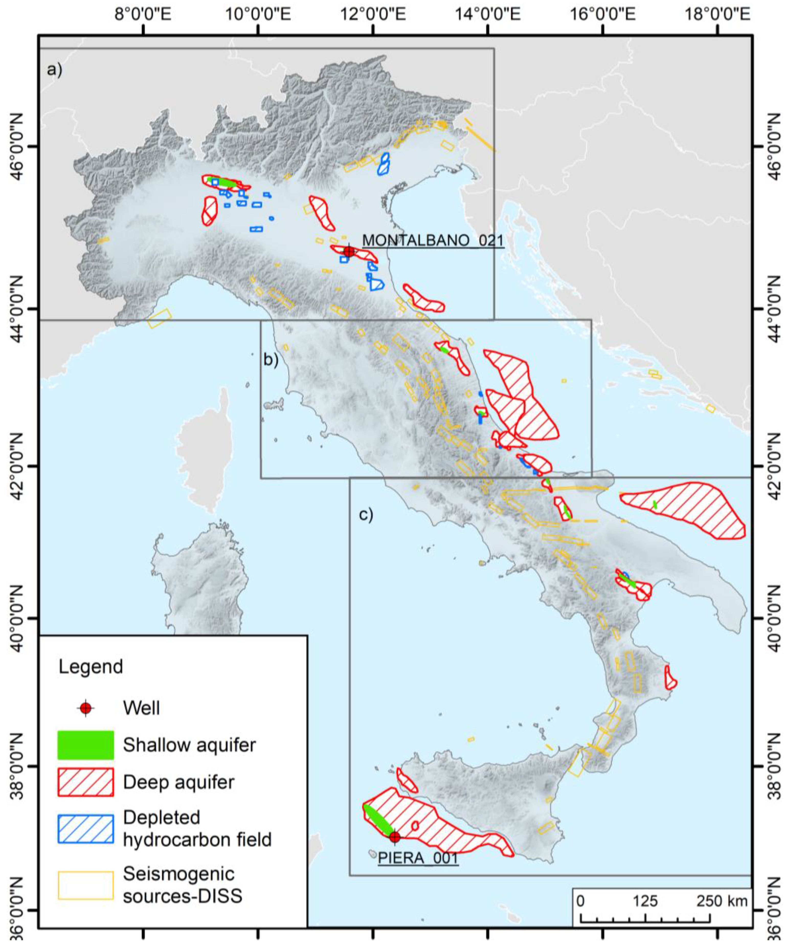
  • The maps presented in this study show for the first time the presence of reservoir–caprock systems at depths of less than 800 m, complementing the previously identified systems and thus providing an almost complete overview of the potential of aquifer formations for UHS.
  • The identification of the shallow systems was based solely on borehole data and is therefore subject to uncertainties, mainly related to the occurrence of local heterogeneities that may influence the behaviour of the injected hydrogen within the reservoir formations. We would therefore like to emphasise that the newly identified shallow systems mentioned above need to be further characterised by analysing the seismic data. Borehole seismic correlation would then allow a better definition of these potential shallow reservoir complexes, as well as the identification of significant tectonic features that could compromise the integrity of the reservoir.
  • In some areas, e.g., the Po Valley, the southern coast of Sicily and north-eastern Italy [18], deep and shallow systems that could offer ‘stacked storage’ are present, and locally there are also overlying depleted gas fields, as in north-western Italy.
These areas require additional site-specific investigations, such as well-log correlation and comprehensive petrophysical characterisation, integrated with geophysical data, such as seismic lines, to define the extension of the reservoirs and understand their true hydrogen storage potential.
  • Regarding depleted gas fields, the estimate of their potential storage capacity calculated here is very conservative and consistent with previous estimates for underground storage. These estimated capacities are affected by the lack of detailed information on potential reservoirs and caprock formations, especially for those sites that are not currently used for gas storage. The reason for the lack of information is twofold: (1) there are very few publications on hydrocarbon resources, and most of them are on a basin scale. Data on individual oil and gas reservoirs, for both active and depleted fields, are scarce in the public literature and often insufficient for adequate site-specific investigation; (2) most of the available well data relate to uneconomic or dry fields, i.e., sites that are not of commercial interest to oil companies, but which provide important information on aquifer formations, as described in the Materials and Methods section (Section 2).
Despite the uncertainties mentioned above, this is the first study demonstrating that there are potentially favourable conditions for UHS in Italy, both in aquifers and in depleted gas fields, both onshore and offshore. This study thus provides the basis for further site-specific analysis.

Author Contributions

Conceptualisation, E.B., F.D. and B.M.; Data curation, E.B.; Formal analysis, E.B., F.D. and Y.L.G.; Funding acquisition, A.R.; Methodology, E.B., F.D. and Y.L.G.; Project administration, B.M.; Software, E.B. and F.D.; Validation, A.R.; Writing—original draft, E.B., F.D. and B.M.; Writing—review and editing, E.B., F.D., B.M., Y.L.G. and A.R. All authors have read and agreed to the published version of the manuscript.

Funding

This work was supported by the Hystories project (https://hystories.eu/, accessed on 14 February 2023). The Hystories has received funding from the Fuel Cells and Hydrogen 2 Joint Undertaking (now Clean Hydrogen Partnership) under grant agreement No. 101007176. This Joint Undertaking receives support from the European Union’s Horizon 2020 research and innovation programme and Hydrogen Europe and Hydrogen Europe Research.

Institutional Review Board Statement

Not applicable.

Informed Consent Statement

Not applicable.

Data Availability Statement

Well-log data are available through the Videpi database at https://www.videpi.com/videpi/pozzi/pozzi.asp (accessed on 12 February 2023). For existing underground gas storages, the hydrogen volumetric capacity is computed from the GIE database https://www.gie.eu/transparency/databases/storage-database/ (accessed on 14 February 2023). For the database of Individual Seismogenic Sources (DISS) https://diss.ingv.it/ (accessed on 12 February 2023).

Acknowledgments

We acknowledge P. Simeoni for the invitation to submit our contribution to this Special Issue and Ceri Vincent of the British Geological Survey for her helpful contribution and suggestions on our paper.

Conflicts of Interest

The authors declare no conflict of interest.

References

  1. IPCC. Global Warming of 1.5 °C; Cambridge University Press: Cambridge, UK, 2022; ISBN 9781009157940. [Google Scholar]
  2. A European Green Deal. Available online: https://commission.europa.eu/strategy-and-policy/priorities-2019-2024/european-green-deal_en (accessed on 14 February 2023).
  3. Miocic, J.; Heinemann, N.; Edlmann, K.; Scafidi, J.; Molaei, F.; Alcalde, J. Underground Hydrogen Storage: A Review. Geol. Soc. Lond. Spec. Publ. 2022, 528, 88. [Google Scholar] [CrossRef]
  4. Heinemann, N.; Alcalde, J.; Miocic, J.M.; Hangx, S.J.T.; Kallmeyer, J.; Ostertag-Henning, C.; Hassanpouryouzband, A.; Thaysen, E.M.; Strobel, G.J.; Schmidt-Hattenberger, C.; et al. Enabling Large-Scale Hydrogen Storage in Porous Media-the Scientific Challenges. Energy Environ. Sci. 2021, 14, 853–864. [Google Scholar] [CrossRef]
  5. Hanley, E.S.; Deane, J.P.; Gallachóir, B.P.Ó. The Role of Hydrogen in Low Carbon Energy Futures–A Review of Existing Perspectives. Renew. Sustain. Energy Rev. 2018, 82, 3027–3045. [Google Scholar] [CrossRef]
  6. Lazarou, S.; Vita, V.; Diamantaki, M.; Karanikolou-Karra, D.; Fragoyiannis, G.; Makridis, S.; Ekonomou, L. A Simulated Roadmap of Hydrogen Technology Contribution to Climate Change Mitigation Based on Representative Concentration Pathways Considerations. Energy Sci. Eng. 2018, 6, 116–125. [Google Scholar] [CrossRef]
  7. Prinzhofer, A.; Tahara Cissé, C.S.; Diallo, A.B. Discovery of a Large Accumulation of Natural Hydrogen in Bourakebougou (Mali). Int. J. Hydrog. Energy 2018, 43, 19315–19326. [Google Scholar] [CrossRef]
  8. Merdith, A.S.; del Real, P.G.; Daniel, I.; Andreani, M.; Wright, N.M.; Coltice, N. Pulsated Global Hydrogen and Methane Flux at Mid-Ocean Ridges Driven by Pangea Breakup. Geochem. Geophys. Geosyst. 2020, 21, e2019GC008869. [Google Scholar] [CrossRef]
  9. Innovation Insights Brief—New Hydrogen Economy—Hype or Hope?|World Energy Council. Available online: https://www.worldenergy.org/publications/entry/innovation-insights-brief-new-hydrogen-economy-hype-or-hope (accessed on 22 January 2023).
  10. Muhammed, N.S.; Haq, M.B.; Al Shehri, D.A.; Al-Ahmed, A.; Rahman, M.M.; Zaman, E.; Iglauer, S. Hydrogen Storage in Depleted Gas Reservoirs: A Comprehensive Review. Fuel 2023, 337, 127032. [Google Scholar] [CrossRef]
  11. Oliveira, A.M.; Beswick, R.R.; Yan, Y. A Green Hydrogen Economy for a Renewable Energy Society. Curr. Opin. Chem. Eng. 2021, 33, 100701. [Google Scholar] [CrossRef]
  12. Heide, D.; von Bremen, L.; Greiner, M.; Hoffmann, C.; Speckmann, M.; Bofinger, S. Seasonal Optimal Mix of Wind and Solar Power in a Future, Highly Renewable Europe. Renew Energy 2010, 35, 2483–2489. [Google Scholar] [CrossRef]
  13. Engeland, K.; Borga, M.; Creutin, J.D.; François, B.; Ramos, M.H.; Vidal, J.P. Space-Time Variability of Climate Variables and Intermittent Renewable Electricity Production—A Review. Renew. Sustain. Energy Rev. 2017, 79, 600–617. [Google Scholar] [CrossRef]
  14. Muhammed, N.S.; Haq, B.; Al Shehri, D.; Al-Ahmed, A.; Rahman, M.M.; Zaman, E. A Review on Underground Hydrogen Storage: Insight into Geological Sites, Influencing Factors and Future Outlook. Energy Rep. 2022, 8, 461–499. [Google Scholar] [CrossRef]
  15. Heinemann, N.; Scafidi, J.; Pickup, G.; Thaysen, E.M.; Hassanpouryouzband, A.; Wilkinson, M.; Satterley, A.K.; Booth, M.G.; Edlmann, K.; Haszeldine, R.S. Hydrogen Storage in Saline Aquifers: The Role of Cushion Gas for Injection and Production. Int. J. Hydrog. Energy 2021, 46, 39284–39296. [Google Scholar] [CrossRef]
  16. Tarkowski, R. Underground Hydrogen Storage: Characteristics and Prospects. Renew. Sustain. Energy Rev. 2019, 105, 86–94. [Google Scholar] [CrossRef]
  17. Züttel, A. Hydrogen Storage Methods. Naturwissenschaften 2004, 91, 157–172. [Google Scholar] [CrossRef] [PubMed]
  18. Mattera, S.; Donda, F.; Tinivella, U.; Barison, E.; Le Gallo, Y.; Vincent, C. First Assessment of an Area Potentially Suitable for Underground Hydrogen Storage in Italy. Int. J. Hydrog. Energy, 2023, in press. [CrossRef]
  19. Ali, M.; Yekeen, N.; Pal, N.; Keshavarz, A.; Iglauer, S.; Hoteit, H. Influence of Pressure, Temperature and Organic Surface Concentration on Hydrogen Wettability of Caprock; Implications for Hydrogen Geo-Storage. Energy Rep. 2021, 7, 5988–5996. [Google Scholar] [CrossRef]
  20. Ozarslan, A. Large-Scale Hydrogen Energy Storage in Salt Caverns. Int. J. Hydrog. Energy 2012, 37, 14265–14277. [Google Scholar] [CrossRef]
  21. Caglayan, D.G.; Weber, N.; Heinrichs, H.U.; Linßen, J.; Robinius, M.; Kukla, P.A.; Stolten, D. Technical Potential of Salt Caverns for Hydrogen Storage in Europe. Int. J. Hydrog. Energy 2020, 45, 6793–6805. [Google Scholar] [CrossRef]
  22. Małachowska, A.; Łukasik, N.; Mioduska, J.; Gębicki, J. Hydrogen Storage in Geological Formations—The Potential of Salt Caverns. Energies 2022, 15, 5038. [Google Scholar] [CrossRef]
  23. Allsop, C.; Yfantis, G.; Passaris, E.; Edlmann, K. Utilising Publicly Available Datasets for Identifying Offshore Salt Strata and Developing Salt Caverns for Hydrogen Storage. Geol. Soc. Lond. Spec. Publ. 2022, 528, 82. [Google Scholar] [CrossRef]
  24. Evans, D.; Parkes, D.; Dooner, M.; Williamson, P.; Williams, J.; Busby, J.; He, W.; Wang, J.; Garvey, S. Salt Cavern Exergy Storage Capacity Potential of UK Massively Bedded Halites, Using Compressed Air Energy Storage (CAES). Appl. Sci. 2021, 11, 4728. [Google Scholar] [CrossRef]
  25. Williams, J.D.O.; Williamson, J.P.; Parkes, D.; Evans, D.J.; Kirk, K.L.; Sunny, N.; Hough, E.; Vosper, H.; Akhurst, M.C. Does the United Kingdom Have Sufficient Geological Storage Capacity to Support a Hydrogen Economy? Estimating the Salt Cavern Storage Potential of Bedded Halite Formations. J. Energy Storage 2022, 53, 105109. [Google Scholar] [CrossRef]
  26. Réveillère, A.; Fournier, C.; Karimi-Jafari, M.; Courault, C. Enabling Large-Scale Hydrogen Storage in Salt Caverns: Recent Developments. In Proceedings of the SMRI Spring 2022 Technical Conference, Spring Rapid City, SD, USA, 5 June 2022. [Google Scholar]
  27. Sainz-Garcia, A.; Abarca, E.; Rubi, V.; Grandia, F. Assessment of Feasible Strategies for Seasonal Underground Hydrogen Storage in a Saline Aquifer. Int. J. Hydrog. Energy 2017, 42, 16657–16666. [Google Scholar] [CrossRef]
  28. Heinemann, N.; Booth, M.G.; Haszeldine, R.S.; Wilkinson, M.; Scafidi, J.; Edlmann, K. Hydrogen Storage in Porous Geological Formations—Onshore Play Opportunities in the Midland Valley (Scotland, UK). Int. J. Hydrog. Energy 2018, 43, 20861–20874. [Google Scholar] [CrossRef]
  29. Luboń, K.; Tarkowski, R. Numerical Simulation of Hydrogen Injection and Withdrawal to and from a Deep Aquifer in NW Poland. Int. J. Hydrog. Energy 2020, 45, 2068–2083. [Google Scholar] [CrossRef]
  30. Zivar, D.; Kumar, S.; Foroozesh, J. Underground Hydrogen Storage: A Comprehensive Review. Int. J. Hydrog. Energy 2021, 46, 23436–23462. [Google Scholar] [CrossRef]
  31. Marcogaz. Injection of Hydrogen/Natural Gas Admixtures in Underground Gas Storage; WG-STO-16-08 (D085); Marcogaz: Brussel, Belgium, 2017; 13p, Available online: https://www.marcogaz.org/wp-content/uploads/2021/04/WG-STO-16-08.pdf (accessed on 12 February 2023).
  32. Buzek, F.; Onderka, V.; Vančura, P.; Wolf, I. Carbon Isotope Study of Methane Production in a Town Gas Storage Reservoir. Fuel 1994, 73, 747–752. [Google Scholar] [CrossRef]
  33. Kruck, O.; Crotogino, F.; Prelicz, R.; Rudolph, T. “Assessment of the Potential, the Actors and Relevant Business Cases for Large Scale and Seasonal Storage of Renewable Electricity by Hydrogen Underground Storage in Europe” Overview on All Known Underground Storage Technologies for Hydrogen Status: D(4). HyUnder 2013, 93. [Google Scholar]
  34. Panfilov, M. Underground and Pipeline Hydrogen Storage. Compend. Hydrog. Energy 2016, 2, 91–115. [Google Scholar] [CrossRef]
  35. Bauer, S.; Beyer, C.; Dethlefsen, F.; Dietrich, P.; Duttmann, R.; Ebert, M.; Feeser, V.; Görke, U.; Köber, R.; Kolditz, O.; et al. Impacts of the Use of the Geological Subsurface for Energy Storage: An Investigation Concept. Environ. Earth Sci. 2013, 70, 3935–3943. [Google Scholar] [CrossRef]
  36. Hemme, C.; van Berk, W. Hydrogeochemical Modeling to Identify Potential Risks of Underground Hydrogen Storage in Depleted Gas Fields. Appl. Sci. 2018, 8, 2282. [Google Scholar] [CrossRef]
  37. Haddad, P.G.; Mura, J.; Castéran, F.; Guignard, M.; Ranchou-Peyruse, M.; Sénéchal, P.; Larregieu, M.; Isaure, M.P.; Svahn, I.; Moonen, P.; et al. Biological, Geological and Chemical Effects of Oxygen Injection in Underground Gas Storage Aquifers in the Setting of Biomethane Deployment. Sci. Total Environ. 2022, 806, 150690. [Google Scholar] [CrossRef]
  38. Pfeiffer, W.T.; Bauer, S. Subsurface Porous Media Hydrogen Storage—Scenario Development and Simulation. Energy Procedia 2015, 76, 565–572. [Google Scholar] [CrossRef]
  39. Kanaani, M.; Sedaee, B.; Asadian-Pakfar, M. Role of Cushion Gas on Underground Hydrogen Storage in Depleted Oil Reservoirs. J. Energy Storage 2022, 45, 103783. [Google Scholar] [CrossRef]
  40. Lord, A.S.; Kobos, P.H.; Borns, D.J. Geologic Storage of Hydrogen: Scaling up to Meet City Transportation Demands. Int. J. Hydrog. Energy 2014, 39, 15570–15582. [Google Scholar] [CrossRef]
  41. RAG Austria AG; AXIOM Angewandte Prozesstechnik GesmbH; Verbund AG; Montanuniversität Leoben; Universität Für Bodenkultur Wien; Energieinstitut an der Johannes Kepler Universität Linz. Underground Sun Storage—Final Report 2017. 13 January 2020. Available online: https://www.underground-sun-storage.at/fileadmin/bilder/03_NEU_SUNSTORAGE/Downloads/Underground_Sun.Storage_Publizierbarer_Endbericht_English.pdf (accessed on 14 February 2023).
  42. Pichler, M. Underground Sun Conversion, Final Report. 2021. Available online: https://www.underground-sun-conversion.at/en/downloads/endbericht.html (accessed on 14 February 2023).
  43. Strobel, G.; Hagemann, B.; Huppertz, T.M.; Ganzer, L. Underground Bio-Methanation: Concept and Potential. Renew. Sustain. Energy Rev. 2020, 123, 109747. [Google Scholar] [CrossRef]
  44. Hystories—Hydrogen Storage in European Subsurface—Hystories. Available online: https://hystories.eu/ (accessed on 12 February 2023).
  45. Civile, D.; Zecchin, M.; Forlin, E.; Donda, F.; Volpi, V.; Merson, B.; Persoglia, S. CO2 Geological Storage in the Italian Carbonate Successions. Int. J. Greenh. Gas Control. 2013, 19, 101–116. [Google Scholar] [CrossRef]
  46. Donda, F.; Volpi, V.; Persoglia, S.; Parushev, D. CO2 Storage Potential of Deep Saline Aquifers: The Case of Italy. Int. J. Greenh. Gas Control. 2011, 5, 327–335. [Google Scholar] [CrossRef]
  47. Bouteldja, M.; Acosta, T.; Carlier, B.; Reveillere, A.; Jannel, H.; Fournier, C. Definition of Selection Criteria for a Hydrogen Storage Site in Depleted Fields or Aquifers. Report D1.1-0. Available online: https://hystories.eu/wp-content/uploads/2021/05/D1.1-0-Selection-criteria-for-H2-storage-sites.pdf (accessed on 14 February 2023).
  48. ESTMAP. Available online: https://estmap.eu/home.html (accessed on 12 February 2023).
  49. CO2 Stop—Assessment of the CO2 Storage Potential in Europe. Available online: https://energy.ec.europa.eu/assessment-co2-storage-potential-europe-co2stop_en?redir=1 (accessed on 12 February 2023).
  50. ViDEPI. Available online: https://www.videpi.com/videpi/videpi.asp (accessed on 12 February 2023).
  51. Seismic Data Network Access Point (SNAP). Available online: https://snap.ogs.trieste.it/cache/index.jsp (accessed on 21 February 2023).
  52. SeaDataNet—SeaDataNet. Available online: https://www.seadatanet.org/ (accessed on 21 February 2023).
  53. European Marine Observation and Data Network (EMODnet). Available online: https://emodnet.ec.europa.eu/en (accessed on 21 February 2023).
  54. Infrastruttura NADC|PNRA. Available online: https://www.pnra.aq/it/infrastruttura-nadc (accessed on 21 February 2023).
  55. DISS Working Group. Database of Individual Seismogenic Sources (DISS), Version 3.3.0; A Compilation of Potential Sources for Earthquakes Larger than M 5.5 in Italy and Surrounding Areas; Istituto Nazionale Di Geofisica e Vulcanologia (INGV): Bologna, Italy, 2021.
  56. Mucciarelli, M.; Donda, F.; Valensise, G. Earthquakes and Depleted Gas Reservoirs: Which Comes First? Nat. Hazards Earth Syst. Sci. 2015, 15, 2201–2208. [Google Scholar] [CrossRef]
  57. Valensise, G.; Donda, F.; Tamaro, A.; Rosset, G.; Parolai, S. Gas Fields and Large Shallow Seismogenic Reverse Faults Are Anticorrelated. Sci. Rep. 2022, 12, 1827. [Google Scholar] [CrossRef]
  58. Goodman, A.; Sanguinito, S.; Levine, J.S. Prospective CO2 Saline Resource Estimation Methodology: Refinement of Existing US-DOE-NETL Methods Based on Data Availability. Int. J. Greenh. Gas Control. 2016, 54, 242–249. [Google Scholar] [CrossRef]
  59. Sanguinito, S.M.; Goodman, A.; Levine, J. NETL CO2 Storage ProspeCtive Resource Estimation Excel ANalysis (CO2-SCREEN) User’s Manual; National Energy Technology Lab. (NETL): Pittsburgh, PA, USA, 2017. [CrossRef]
  60. Gorecki, C.; Sorensen, J.; Ayash, S.; Knudsen, D.; Holubnyak, Y.; Smith, S.; Steadman, E.; Harju, J. Development of Storage Coefficients for Carbon Dioxide Storage in Deep Saline Formations; Technical Study Report; EERC, University of North Dakota: Grand Forks, ND, USA, 2009. [Google Scholar]
  61. Heidug, W. Methods to Assess Geologic CO2 Storage Capacity: Status and Best Practice; Workshop Report; International Energy Agency (IEA) Publications: Paris, France, 2013. [Google Scholar]
  62. Juanes, R.; Macminn, C.W.; Szulczewski, M.L. The Footprint of the CO 2 Plume during Carbon Dioxide Storage in Saline Aquifers: Storage Efficiency for Capillary Trapping at the Basin Scale. Transp. Porous. Med. 2010, 82, 19–30. [Google Scholar] [CrossRef]
  63. Hystories Working Group. 3D Multi-Realization Simulations for Fluid Flow and Mixing Issues at European Scale; Report D2.2 Under EU Review and Approval. 2022. Available online: https://hystories.eu/publications-hystories/ (accessed on 12 February 2023).
  64. CO2 Storage Resources Management System. Available online: https://www.spe.org/en/industry/co2-storage-resources-management-system/ (accessed on 14 February 2023).
  65. GIE—Gas Infrastructure EuropeGas Infrastructure Europe. Available online: https://www.gie.eu/transparency/databases/storage-database/ (accessed on 14 February 2023).
  66. Volpi, V.; Forlin, E.; Baroni, A.; Estublier, A.; Donda, F.; Civile, D.; Caffau, M.; Kuczynsky, S.; Vincké, O.; Delprat-Jannaud, F. Evaluation and Characterization of a Potential CO2 Storage Site in the South Adriatic Offshore. Oil Gas Sci. Technol. Rev. d’IFPEN 2015, 70, 695–712. [Google Scholar] [CrossRef]
  67. Volpi, V.; Forlin, F.; Donda, F.; Civile, D.; Facchin, L.; Sauli, S.; Merson, B.; Sinza-Mendieta, K.; Shams, A. Southern Adriatic Sea as a Potential Area for CO2 Geological Storage. Oil Gas Sci. Technol. Rev. d’IFP Energ. Nouv. 2015, 70, 713–728. [Google Scholar] [CrossRef]
  68. Cihlar, J.; Mavins, D.; Van der Leun, K. Picturing the Value of Underground Gas Storage to the European Hydrogen System; Guidehouse: Chicago, IL, USA, 2021. [Google Scholar]
  69. Heinemann, N.; Wilkinson, M.; Adie, K.; Edlmann, K.; Thaysen, E.M.; Hassanpouryouzband, A.; Haszeldine, R.S. Cushion Gas in Hydrogen Storage—A Costly CAPEX or a Valuable Resource for Energy Crises? Hydrogen 2022, 3, 550–563. [Google Scholar] [CrossRef]
Figure 1. Map of the distribution of the potential UHS site in Italy. The box (a) show the location of the Figures 2 and 6, the box (b) of Figures 4 and 7 and box (c) of Figures 5 and 8. The red dots show the location of the two wells of Figure 3. The Deep aquifers have been adapted with permission from [46], copyright 2011, Clearance Center’s RightsLink®, license number 5531860610147 and from [45] copyright 2013, Clearance Center’s RightsLink®, license number 5531860461515. The depleted hydrocarbon fields location derive from public database available at https://unmig.mite.gov.it/stoccaggio-del-gas-naturale/ (accessed on 12 February 2023) except from “Treviso” adapted from [18], copyright 2023, Clearance Center’s RightsLink®, license number 5531860261161.
Sustainability 15 06886 g001
Figure 2. Detailed map of the aquifers identified in northern Italy. The red dot is the well Montalbano_021 (Figure 3). The yellow and red ellipses indicate the areas detailed in the text. The Deep aquifers have been adapted with permission from [46], copyright 2011, Clearance Center’s RightsLink®, license number 5531860610147 and from [45] copyright 2013, Clearance Center’s RightsLink®, license number 5531860461515.
Sustainability 15 06886 g002
Figure 3. Stratigraphy logs of the wells Montalbano_021 and Piera_001. Modified after VIDEPI database (license CC BY 3.0 IT) [50]. The location is reported in Figure 1, Figure 2 (Montalbano_021) and Figure 5 (Piera_001).
Sustainability 15 06886 g003
Figure 4. Detailed map of the aquifers identified in central Italy. The yellow ellipse indicates the area detailed in the text. The Deep aquifers have been adapted with permission from [46], copyright 2011, Clearance Center’s RightsLink®, license number 5531860610147 and from [45] copyright 2013, Clearance Center’s RightsLink®, license number 5531860461515.
Sustainability 15 06886 g004
Figure 5. Detailed map of the aquifers identified in southern Italy. The red dot is the location of the well Piera_001 (Figure 3). The Deep aquifers have been adapted with permission from [46], copyright 2011, Clearance Center’s RightsLink®, license number 5531860610147 and from [45] copyright 2013, Clearance Center’s RightsLink®, license number 5531860461515.
Sustainability 15 06886 g005
Figure 6. Detailed map of the depleted hydrocarbon fields identified in northern Italy. The depleted hydrocarbon fields location derive from public database available at https://unmig.mite.gov.it/stoccaggio-del-gas-naturale/ (accessed on 12 February 2023) except from “Treviso” adapted from [18], copyright 2023, Clearance Center’s RightsLink®, license number 5531860261161.
Sustainability 15 06886 g006
Figure 7. Detailed map of the depleted hydrocarbon fields identified in central Italy. The depleted hydrocarbon fields location derive from public database available at https://unmig.mite.gov.it/stoccaggio-del-gas-naturale/ (accessed on 12 February 2023).
Sustainability 15 06886 g007
Figure 8. Detailed map of the depleted hydrocarbon fields identified in southern Italy. The depleted hydrocarbon fields location derive from public database available at https://unmig.mite.gov.it/stoccaggio-del-gas-naturale/ (accessed on 12 February 2023).
Sustainability 15 06886 g008
Table 4. Parameters of the analysed fields from Gas Infrastructure Europe database.
ReservoirReservoir PressureReservoir PermeabilityReservoir PorosityWorking Gas
(Technical) TWh
Working Gas
Third-Party Access
TWh
Working Gas
No Third-Party Access
TWh
Injection
Technical
GWh/Day
Injection
Third-Party Access
GWh/Day
Withdrawal
Technical
GWh/Day
Withdrawal
Third-Party Access
GWh/Day
Access
Regime
Alfonsine84.420–1200.2–0.281.551.55n. a.25.8625.8625.8625.86rTPA 2
Bagnolo Mella123.5330.247.227.22n. a.n. a.n. a.n. a.n. a.rTPA 2
Bordolanon. a. 3n. a.n. a.2.582.58n. a.n. a.n. a.20.6920.69rTPA 2
Brugherion. a.n. a.n. a.18.3 113.4 14,8 1159 1159 1268 1268 1rTPA 2
Collalton. a.110.05–0.23.6 13.6 1n. a.25.8 125.8 131.2 131.2 1rTPA 2
Corneglianon. a.n. a.n. a.1.581.58n. a.15.1215.1221.6021.60rTPA 2
Cortemaggioren. a.n. a.n. a.18.3 113.4 14.8 1159 1159 1268 1268 1rTPA 2
Cugno le Macine (Grottole)n. a.n. a.n. a.4.4 14.4 1n. a.55 155 155 155 1rTPA 2
Cugno le Macine (Ferrandina)n. a.n. a.n. a.4.4 14.4 1n. a.55 155 155 155 1rTPA 2
Fiume Tresten. a.n. a.n. a.2.072.07n. a.n. a.n. a.41.3841.38rTPA 2
Minerbio1402500.13–0.374.354.35n. a.n. a.n. a.n. a.n. a.rTPA 2
Poggiofiorito83n. a.n. a.1.831.220.6118.7018.7018.7018.70rTPA 2
Ripalta stoccaggion. a.n. a.n. a.3.723.72n. a.20.6920.69n. a.n. a.rTPA 2
Romanengon. a.n. a.6.53.6 13.6 1n. a.25.8 125.8 131.2 131.2 1rTPA 2
S.Potito-Cotignola (Cotignola)n. a.n. a.n. a.3.6 13.6 1n. a.25.8 125.8 131.2 131.2 1rTPA 2
Sabbioncellon. a.n. a.n. a.1.661.66n. a.n. a.n. a.62.0762.07rTPA 2
San Benedetto297n. a.0.14–0.195.743.831.9165.3465.3465.3465.34rTPA 2
Sergnano140500–8000.1–0.21.661.66n. a.n. a.n. a.n. a.n. a.rTPA 2
Settalan. a.n. a.n. a.3.623.62n. a.n. a.n. a.n. a.n. a.rTPA 2
Sinarca stoccaggion. a.n. a.n. a.3.562.381.1935.2035.2035.2035.20rTPA 2
1 Estimated from storage group. 2 rTPA = regulated Third-Party Access. 3 not available.
Table 5. Estimated capacity of the analysed fields.
ReservoirHydrogen Static Volume (MMSm3)Hydrogen Static Volume (TWh) 1
Ripalta stoccaggio20736.6
Sergnano18785.9
Cugno le Macine (Grottole)8002.5
Romanengo 3401.1
Alfonsine 18685.9
Bordolano 19666.2
Bagnolo Mella 6792.2
Cornegliano1490.5
Minerbio 21326.7
Settala 20636.5
S. Potito-Cotignola (Cotignola)3401.1
Collalto 3401.1
San Benedetto5411.7
Poggiofiorito 1720.5
Sinarca stoccaggio 3361.1
Cugno le Macine (Ferrandina)8282.6
Fiume Treste 1950.6
Sabbioncello 17225.5
Brugherio 17225.5
Cortemaggiore 17225.5
Italian Capacity21,87669.2
1 TWh =TeraWatt-hour (1012 Watt-hour) assuming low heating value for hydrogen equals 33.33 KWh/Kg, i.e., 3.0 × 10⁻³ TWh/MMSm3
Disclaimer/Publisher’s Note: The statements, opinions and data contained in all publications are solely those of the individual author(s) and contributor(s) and not of MDPI and/or the editor(s). MDPI and/or the editor(s) disclaim responsibility for any injury to people or property resulting from any ideas, methods, instructions or products referred to in the content.

