1. Introduction
1.1. Research Purpose and Preceding Research
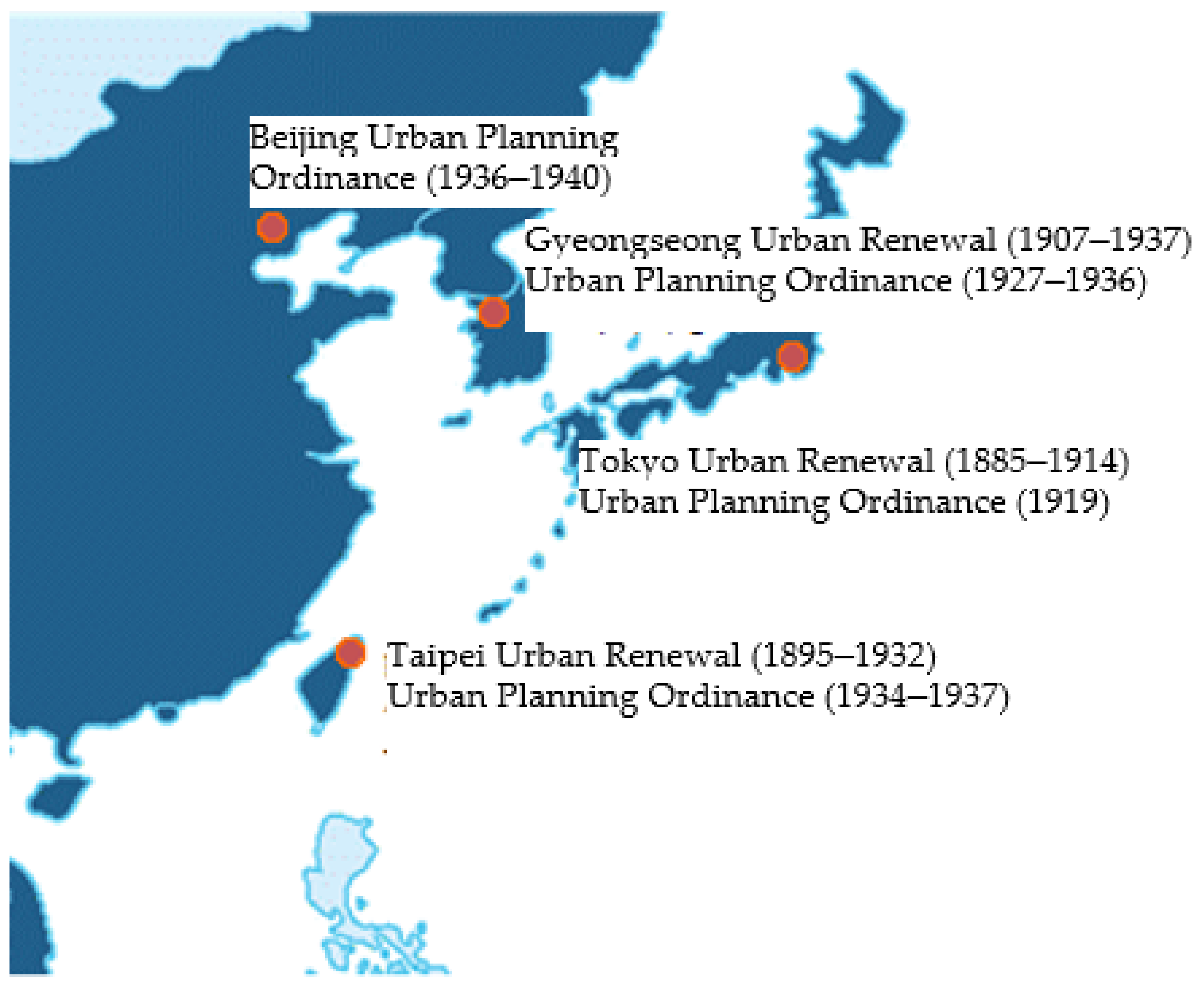
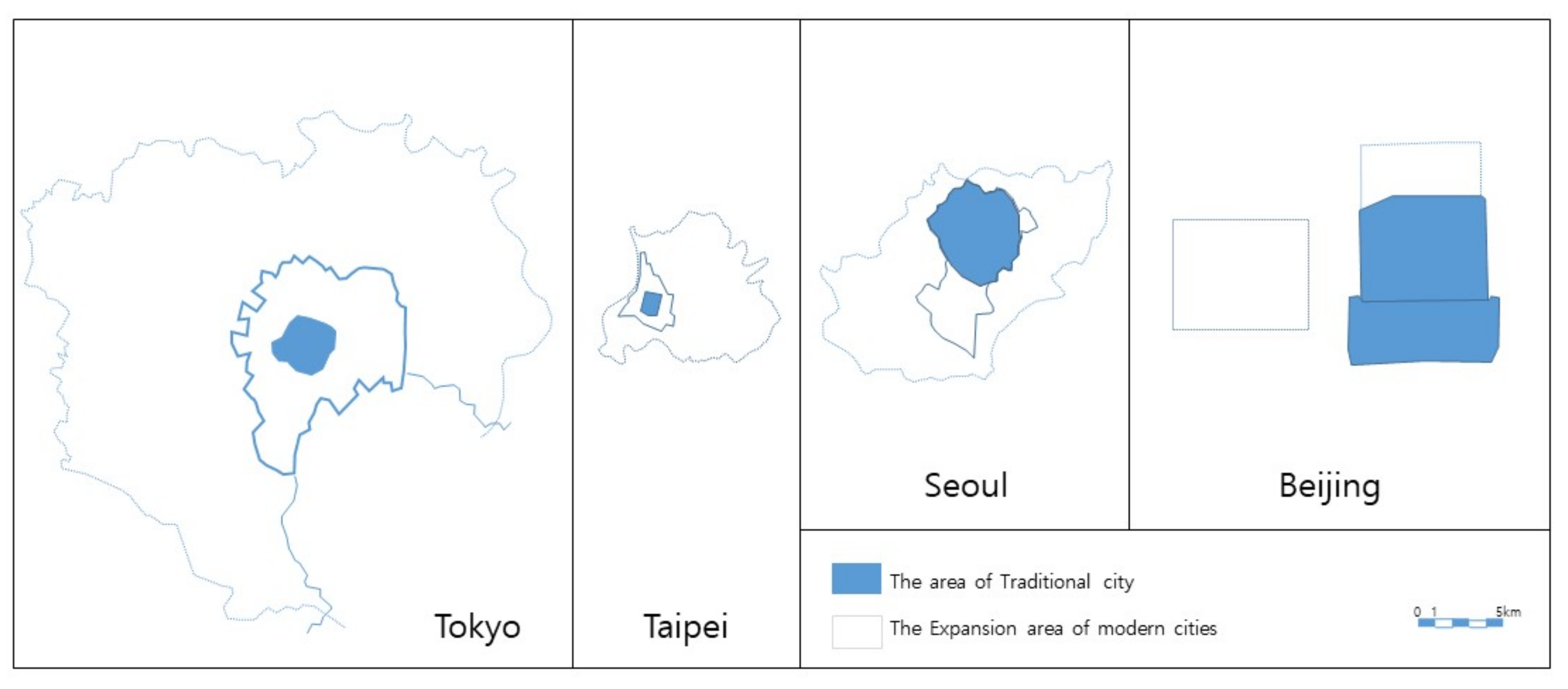
Japan’s urban planning system has changed in various ways through the Tokyo City Improvement Ordinance (1888) and the City Planning Law (1919). From 1895 to 1945 (Japanese colonization era), Japan applied and tested its urban planning in Taipei (1895–1945), Seoul (1910–1945, Gyeongseong, reported as Seoul in the text except for the maps and laws), and Beijing (1936–1945). The present study aims at examining the characteristics of Tokyo’s urban planning and revealing how Japan’s urban planning transformed these cities in East Asia, which had different cultures and styles, during Japanese colonial rule (see
Figure 1).
There has been a pile of previous studies on each city’s urban planning during Japanese colonial rule. Studies on Tokyo’s urban planning include Yorihusa Ishida’s study on the history of Japan’s land readjustment systems [
1], Akira Koshizawa’s study on Tokyo’s urban planning [
2], and Terunobu Fujimor’s study on urban planning in Tokyo [
3].
Studies on Seoul’s urban planning during Japanese colonial rule include Koshizawa’s study on social capital rebuilding [
4], Son Jung-mok’s historical study [
5], Yasushi Goto’s study on street renewal in Seoul [
6,
7], and Yum Bok-gyu’s study on urban planning process and urban expansion [
8].
Studies on Taipei during Japanese colonial rule include Koshizawa’s study and Hwang Se-maeng’s historical study [
9,
10] and Goto’s study on the formation of households in Taipei [
11,
12,
13]. Studies on Beijing include Koshizawa’s historical study [
14] and Yoon Hyung-jin’s study on urban planning [
15].
Comparative studies include Goto’s research on the system of urban renewal in Seoul and Taipei [
16,
17]. Goto analyzed the changed use of spaces due to the collapse of feng shui geomancy and explained the renovation and formation of downtown Seoul and Taipei as urban renewal. Bae Hyun-mi’s comparative study focused on the formation of downtowns in Korea and Japan [
18] and Kim Baek-young’s comparative study investigated urban renewal in Seoul and Tokyo [
19]. Goto’s study compares each ordinance’s establishment process and practical differences in Joseon’s Seoul, Taiwan’s Taipei, and China’s Dalian and Manchuria under colonial rule [
17].
Prior studies have either focused on various topics of cities under Japanese colonial rule or compared them to Tokyo. The capitals of East Asia possess the characteristic of being traditional cities prior to Japanese colonial rule. This study aims to uncover the distinct characteristics of urban planning by comparing and analyzing the effects of Japanese urban planning on the capitals of East Asian countries during the colonial era.
1.2. Research Method
As a way to understand things, it can be useful to classify them one by one and grasp the meaning of each object, rather than recognizing the whole as a single entity and establishing relationships between them. Analytical methods that categorize objects individually, quantify them, and study them quantitatively are widely used.
Analyzing involves comparing and classifying the properties of objects, identifying their relationships accurately, and ultimately determining their properties. Interpretation involves identifying the meaning of causes, processes, results, and reasons based on special facts, viewed from the perspective of probabilism rather than determinism. It is a task that differs from the analytical method. In particular, when dealing with complexly intertwined elements, such as in a city, taking a holistic approach and recognizing the whole as one entity is often more effective.
Therefore, in this study, a holistic and interpretive approach is used, rather than an analytical approach. The purpose of the study is to identify the similarities and differences in how urban planning and development methods were applied to Tokyo, the capital of Japan, during the Japanese colonial period, and to its colonies Taipei, Seoul, and Beijing. The interpretative method is judged to be more effective for this purpose. The study reviews the existing urban planning laws and development methods for each city, including studies and references that examine actual applied cases. For the overall interpretation, maps of each city era are compared at the same scale. However, the lack of figures or graphs compared to analytical and quantitative research methods is considered a limitation of the interpretive method.
2. Modern Urban Planning in Tokyo
2.1. Tokyo Urban Renewal
Although Tokyo, which had been an administrative capital for 415 years, had good sewage works, the city needed to prepare against fire in densely located wooden buildings, build sanitation works and roads, and rebuild infrastructure as a modern city. Edo was the predecessor of Tokyo and was comprised of Musashi, Sasaji, and Choningji, centered around Edo Castle. As it was situated along the waterfront for water transportation, its location was favorable in terms of topography, but it did not take into consideration Feng Shui, unlike other traditional cities [
20].
By the Meiji period (1868–1912), a need to overhaul Tokyo had been recognized, and Governor Matsuda Michiyuki planned to renovate roads and streams in the areas lost to a fire in 1879 [
21]. In 1885, Governor Yoshikawa Akimasa established the Tokyo Urban Renewal Review Committee in the Home Ministry and planned to build railroads, ports, and parks, but the project was not realized [
21]. In the same period, Inoue Kaoru from the Ministry of Foreign Affairs created the Temporary Construction Bureau and established the ‘Government Agency Focus Plan’ [
19]. To plan water and sewage works as part of the Government Agency Focus Plan, James Hobrecht was invited from Germany in March 1887 [
3]. In addition, William K. Burton was hired in the Sanitary Bureau of the Home Ministry in 1887 and put in charge of the primary plan for water and sewage works not only in Tokyo but also Kobe, Fukuoka, and Okayama. On 16 August 1888, the Home Ministry announced the Tokyo City Improvement Ordinance and established the Tokyo Urban Renewal Committee [
21]. Regulations on buildings were reviewed at that time but not included. In 1889, the proposed plan was made public, but could not make progress due to funding problems and was eventually cut significantly in 1903. After the Russo–Japanese War, the Temporary Urban Renewal Bureau was established in Tokyo in 1906, and the Urban Renewal Plan was completed in 1914 as originally intended in 1903.
2.2. City Planning Law
While urban planning focused on how to modernize the city in the 19th century, a discussion on how to expand it was a major challenge in the 20th century. In 1919, the first modern City Planning Law and Urban Building Code were signed into law. The objectives of the City Planning Law as an extension of the Tokyo City Improvement Ordinance (1888) were to expand the city, planned areas, planned items, funding sources, and land expropriation. Compared to the Tokyo City Improvement Ordinance, it established the way of thinking that urban planning is a comprehensive overhaul of the entire city. It was more progressive as it created limits, zoning, land readjustment, structure expropriation, and benefit principles in urban planning and recognized overcapacity [
2].
With the implementation of the City Planning Law, the Tokyo Urban Planning Road Network was determined in May 1921, and Tokyo Urban Planning Zones were determined in April 1922. After the 1923 Great Kantō earthquake, Tokyo Mayor Gotō Shinpei, as Minister of Home Affairs and Governor of Imperial City Redevelopment, established the Imperial City Redevelopment Plan that included land readjustment and the renewal of parks and main roads. Gotō was a political leader who ruled Taiwan in 1898 after he studied in Germany and returned home in 1890. After the Taiwanese Survey Project, he was appointed as the President of the South Manchuria Railway in 1906 and put in charge of building infrastructure for the South Manchuria Railway with Dalian as a hub, expanding sanitation works and constructing cities. From 1920 to 1923, he served as Tokyo Mayor and led Tokyo’s Imperial City Redevelopment Plan based on his urban planning experience in Taipei and Dalian [
22].
Since then, the Main Road Network was determined for Tokyo Urban Planning Zones in August 1927. Inside Tokyo, radial line and ring roads originating from Tokyo Station were planned with the focus on connecting and expanding Tokyo and its suburban areas outward. The City Planning Law enacted in 1919 was revised in March 1933 and it provided the basis to discuss urban planning for Joseon, Manchuria, and Taiwan.
2.3. Applicable Building Codes
Tokyo Urban Renewal Land and Building Disposition Regulations (1889) imposed limits on the land rights [
21]. The proposed Tokyo Building Ordinance was planned in 1894 and 1913 but was not legislated. In 1919, the Urban Building Code was introduced nationwide.
3. Modern Urban Planning during the Colonization Era
3.1. Taipei’s Modern Urban Planning
3.1.1. Urban Renewal in Taipei
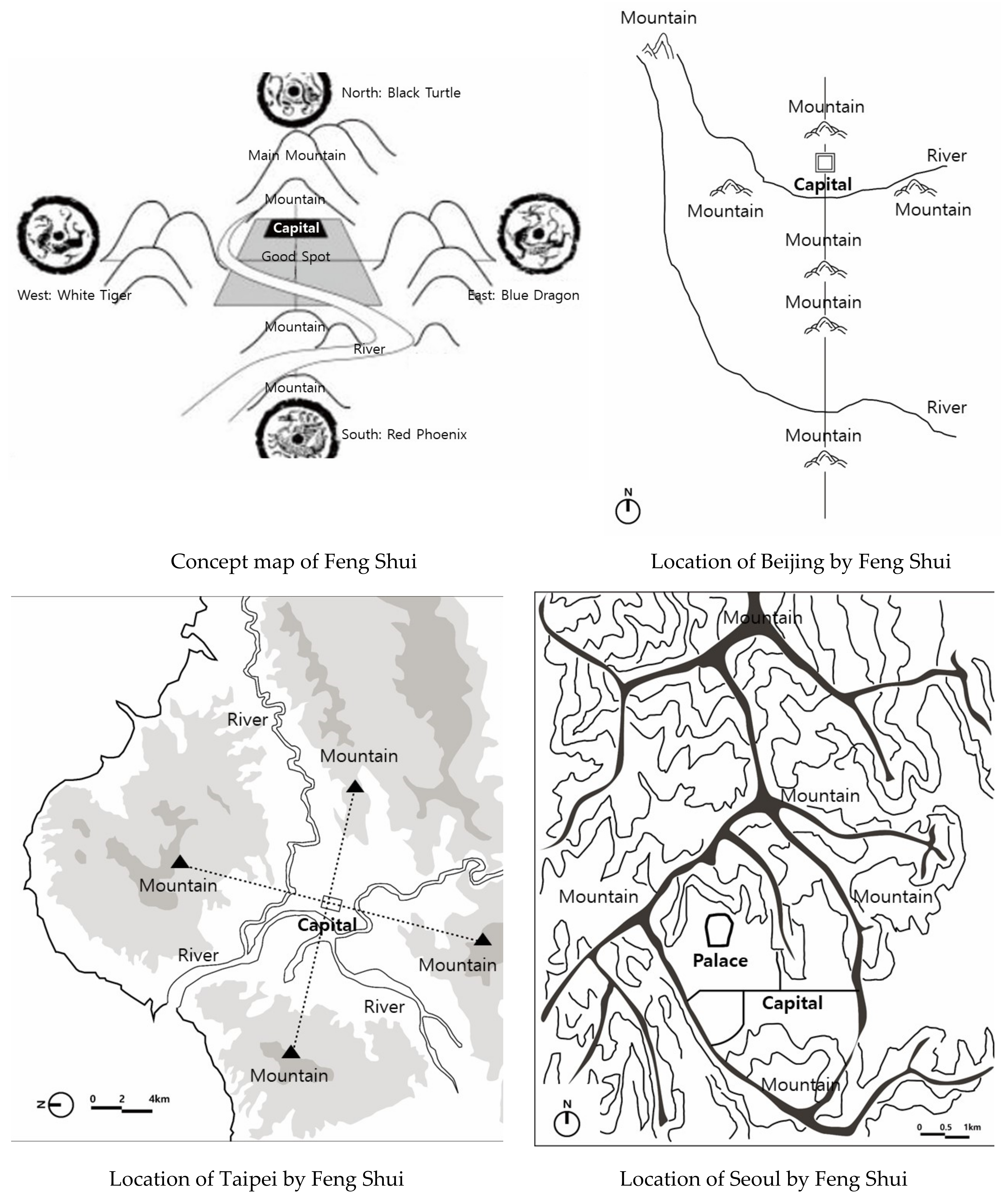
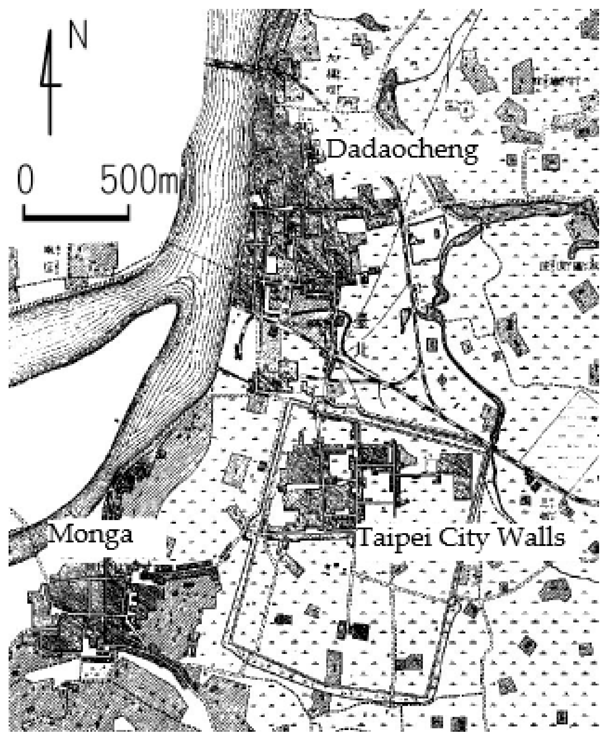
In 1895, Taipei had three downtowns: Monga, Dadaocheng, and Taipei City Walls. Monga and Dadaocheng had grown with water transport in a brine river, and the inside of Taipei City Walls was a government agency district built as a result of the establishment of Taipei Prefecture in 1874. Taipei City was planned and constructed at the end of the Qing Dynasty, and its design was influenced by the characteristics of Chinese traditional city planning and Feng Shui. The axis of the city was determined based on a specific mountain surrounding it, and the presence of the Four Gods demonstrates the influence of Feng Shui [
23] (
Figure 2).
Japan, to which Taiwan had been ceded from the Qing dynasty after the Sino-Japanese War, established the Government-General of Taiwan inside Taipei City Walls in 1896. At that time, Taipei had sanitation issues in downtowns. Under the leadership of Director Gotō of the Sanitary Bureau of the Home Ministry in Japan, W.K. Burton, an advisor for sanitation works, established an urban renewal plan with sanitation as a keyword.
Taipei’s urban renewal was implemented over the course of six plans. The 1st Plan (1895) established temporary ditches around the city walls to prevent a flood inside Taipei City Walls when a brine river was flooded. The 2nd Plan (1896) invited Burton to ensure cleanliness and installed open channel sewage works. The 3rd Plan (1900) announced a road plan inside Taipei City Walls. The 4th Plan (1901) announced a decision for urban renewal near the south and east gates of the city walls to expand the downtown. The 5th Plan (1905) attempted to combine the inside of Taipei City Walls, Dadaocheng, and Monga to form a large city. Monga and Dadaocheng were designed in a way that made the best use of existing roads due to budget problems. It was planned to demolish the city walls and build 25–40 kan (unit of measurement) wide mountain roads in their place. Even though the 5th Plan estimated that the population would have reached its peak by 1932, the city had already grown to a population of 170,000 in 1922. Accordingly, the 6th Plan (1932) established an urbanization plan for 600,000 people. The 1932 Great Taipei Urbanization Plan was mainly about connecting roads to suburban areas and creating parks [
24,
25,
26].
3.1.2. Taiwanese City Planning Law
The Taiwanese City Planning Law combined building and land readjustment laws with urban planning ones and improved upon Japan’s City Planning Law. In September 1934, the City Planning Law Implementation Preparation Committee was established in the Government-General of Taiwan. After meetings in February and August 1935, the law was announced on 27 August 1936 and enforced from 1 April 1937. The Taiwanese City Planning Law included urban planning special taxes and benefit principles, based on which land expropriation, land readjustment, parks, streets, sewerage works, and zoning were set up. Unlike other countries, the Taiwanese City Planning Law had a unique provision that did not permit building outside the planned area. In addition, a provision that required buildings be connected to roads prohibited the construction of buildings in unplanned or unorganized areas [
27].
The following aspects were improved institutionally from Japan’s City Planning Law [
25]. The scope of zoning was made consistent with the scope of areas under urban planning. It allowed the city to designate special districts in addition to commercial and residential ones. As improvements in land readjustment, only the landowner could readjust land, and in case of forced implementation, land was readjusted by authority from the Government-General of Taiwan. In addition, limits on personal property rights, which were only possible because it was a colonial city, enabled planned downtown expansion and control [
24,
25,
26].
3.1.3. Applicable Building Codes
In the 1890s, the Longhouse Construction Rules were established across many parts of Japan and, on their basis, the Taipei Housing Construction Rules (25 November 1896), applicable to Japanese people living in Taiwan, were enforced. On 29 April 1897, the Government-General of Taiwan organized the Taipei Urban Renewal Committee as a body that reviewed urban renewal and sanitation works [
17]. The Taipei Urban Renewal Committee enacted the Taiwanese House Construction Rules in August 1900, which had been used until 1936, when the Taiwanese City Planning Law was announced [
17]. While it had some differences in terms of dimensions from Japan’s Longhouse Construction Rules, other construction regulation items, including building lines, fire protection, and sanitation works, were almost the same [
27].
3.2. Seoul’s Modern Urban Planning
3.2.1. Urban Renewal in Seoul
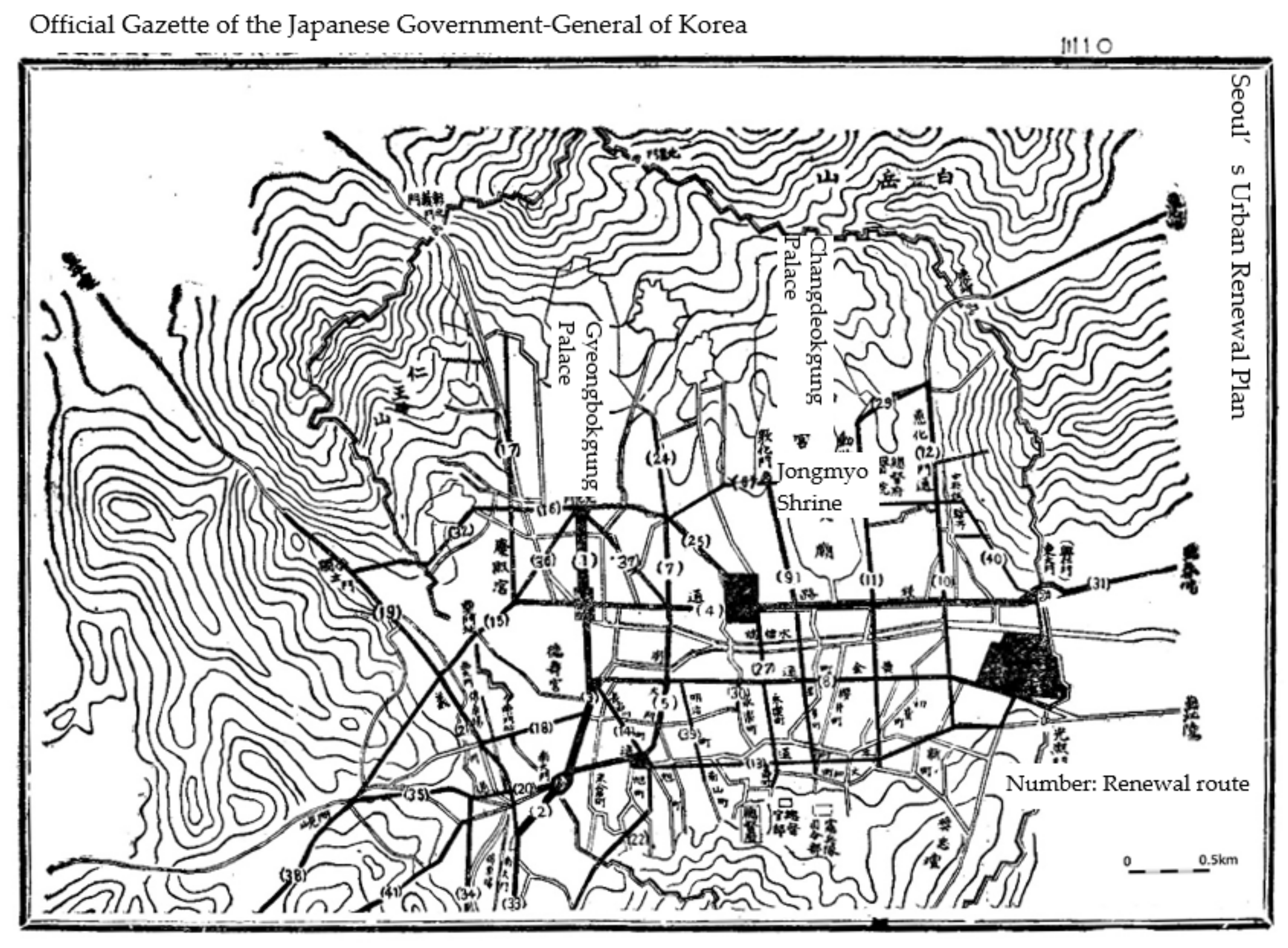
The predecessor of Kyungsung was Hanyang during the Joseon dynasty. Hanyang was designed under the influence of Feng Shui, and the arrangement of spaces such as Jongmyo Shrine, Sajikdan Alter, the palace, and government offices were influenced by the Chinese capital-city system based on Kaogongji. Jongmyo (1395) is the supreme state shrine where the royal ancestral tablets of deceased kings and queens are enshrined, and sacrificial rites are performed for them. Sajikdan Altar is an ancient altar for memorial services whose name, ‘Sajikdan’, means to ‘pray for the comfort and prosperity of the country and its people’ [
28] (
Figure 2).
With the Japan–Korea Treaty of 1904, Japan gained the right to provide administrative advice and turned Korea into a protectorate under the Eulsa Treaty in 1905, establishing the Japanese Resident-General of Korea. Then, the Government-General of Joseon was created after the Japan–Korea Annexation Treaty in 1910. Seoul’s urban renewal aimed at improving transport convenience and renewing the city’s outer look, as shown by the focus on renovating roads and the fact that the project was expedited to show off before the Joseon Industrial Exhibition in 1915 and the Joseon Exhibition in 1929.
In Seoul, urban planning was led by administrators, and urban renewal was implemented by Itō Hirobumi, the Resident-General of Korea at that time [
7]. Urban renewal implemented by the Resident-General of Korea began with Namdaemun Road Rebuilding in 1907 to operate trams. The Government-General of Joseon rebuilt the remaining parts of Gold Town Street as part of the State-funded road paving in 1911 and put forward the notice ‘Line 29 Planned for Urban Renewal’ in 1912 [
7]. The plan arranged grid roads, a circular square, and radial line roads around Jongno and Namdaemun. Roads in the south and north directions were mainly rebuilt, and the only completed road in the east and west directions was a line connecting the square in front of Daehanmun, Gold Town Street, and the outside of Gwanghuimun. Urban renewal was not implemented for the roads which had already enough width.
In June 1919, urban renewal was launched, which included downtown expansion around Yongsan and Mapo and revisions to the original plan. Roads connecting to Yongsan were added, and streets placed radially around the square were removed. Instead, radial line roads in front of Gwanghwamun were newly added.
Due to financial reasons, the urban renewal project had been transferred from the Government-General to Gyeongseong Prefecture since 1929 [
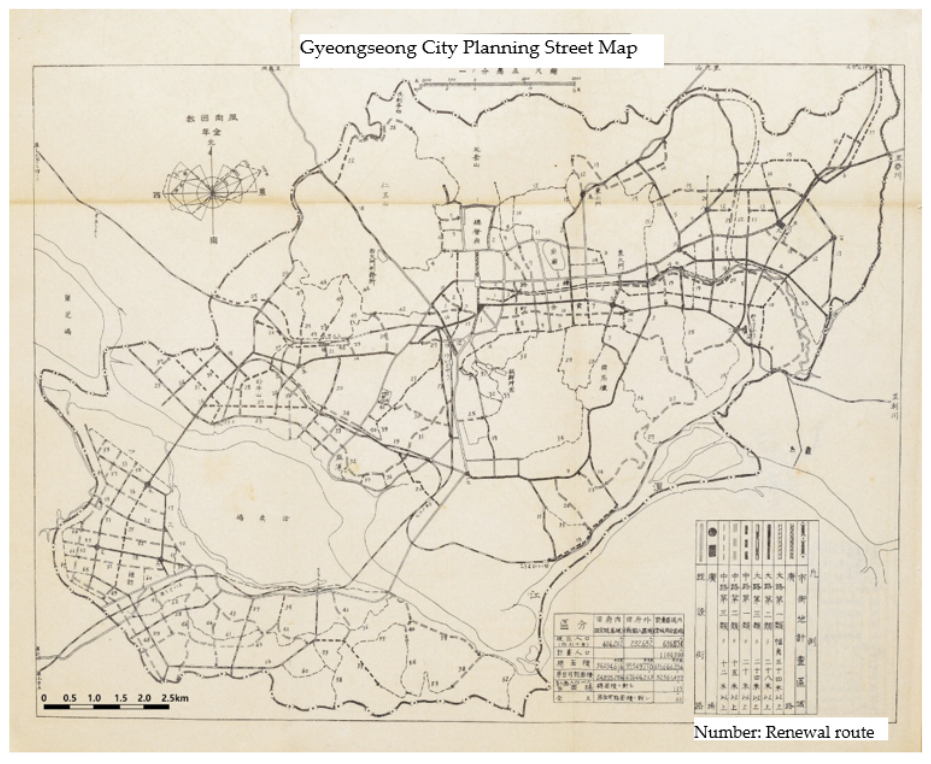
8]. According to Gyeongseong Downtown Planned Street Network Map in 1936, the number of streets reached 220 and roads from inside the fortress walls were rebuilt and connected to other cities.
3.2.2. Joseon City Planning Ordinance
The Joseon City Planning Ordinance was Korea’s first modern city planning law enacted in 1934. In 1936, the Joseon City Planning Ordinance applied to Kyungseong Prefecture, following Najin. In December 1936, the Kyungseong Downtown Planned Street Network Map was determined with No. 722. In Joseon, there was some movement for the City Planning Ordinance in 1922 when the Internal Affairs Bureau of the Government-General drew up a draft city planning law, but it had been discontinued for quite some time [
8]. In December 1927, it was re-discussed as Governor-General Yamanashi Hanzō of Korea and Inspector-General Shirou Ikegami of Political Affairs were inaugurated [
8]. Ikegami served as Osaka Mayor and attempted urban planning several times in Japan. In January 1928, the Urban Planning Research Association filed a motion to implement a ‘complete city planning law’ which included the Urban Planning Committee, land readjustment, zoning, and benefit principles [
8]. Okazaki Shotaro, who was a renowned figure in urban planning, was invited and the Joseon Downtown Planning Ordinance was completed in July 1931 [
8]. However, since the second half of 1931, right after Kazushige Ugaki was appointed as Governor-General, the direction of urban planning was changed due to Joseon industrialization policies, and discussions began again on the city planning law to accommodate the changed direction [
8]. At that time, the City Planning Law was acknowledged in Japan as a tool for the State to efficiently mobilize resources such as land or population, not to tackle urban problems; therefore, the law was revised in a way that tightened control (
Table 1). As the City Planning Ordinance was proposed, the Temporary Urban Planning Section was reorganized into the official Urban Planning Section under the Department of Civil Works, and the Kyungseong Urban Planning Survey Committee was organized in July 1933. While the original City Planning Ordinance followed the Japanese legal system, it accepted opinions on ‘matters required to rule Joseon and ensure industrial status,’ and a draft was completed in the early 1933 and announced in June 1934, after government review in homeland Japan [
29]. It was mainly about items subject to urban planning, authority for urban planning, land readjustment, and zoning. Compared to the lines planned for urban renewal, this phase expanded the planned areas and adopted the metric system as a unit for street width as per regional expansion under Government-General Ordinance No. 8 on 14 February 1936. The Joseon City Planning Ordinance was characterized by the fact that it mainly focused on setting up planned streets and land readjustment districts. The ordinance emphasized that it was a national project, granted all decision-making and enforcement rights to the Governor-General, and did not establish an advisory body with legal status, unlike Japan. For zoning, it set forth unspecified areas that had no particular aims as well as industrial, commercial, and residential areas.
In Japan, Seoul urban planning was evaluated as advanced ‘Even though the administrative agency needs to implement this urban planning project all together since Joseon has a lack of knowledge and experience and its people’s level is low’ [
30]. In addition, it was also assessed that ‘There is little progress in land readjustment projects in Japan since there are too many discussions as associations implement them, but this project is expected to make smooth progress in Joseon as it is implemented by the State’ [
31].
3.2.3. Applicable Building Codes
The first building code introduced in Korea was applied to Japanese people living in Joseon such as Taiwan. The implementation of the building code began in residential areas for Japanese people in opened ports, and the scope of the law broadened as the residential areas of Japanese people spread more widely. Unlike opened ports, no law governing buildings was found for Seoul, and roof material regulations for fire protection and house regulations for parts in contact with roads were put in place [
27]. On 17 April 1911, the Road Rules and the Land Expropriation Ordinance were applied. In February 1913, Government-General Ordinance No. 11 Downtown Building Control Rules was issued. The Downtown Building Control Rules were set up without direct relations to urban renewal. The rules defined building coverage ratio, building lines, building materials, associated facilities, aesthetics, and disaster prevention. The Downtown Building Control Rules were incorporated into a single urban building code by the Joseon City Planning Ordinance in 1934.
3.3. Beijing’s Modern Urban Planning
3.3.1. Beijing Urban Planning Outline
The Beijing Wall was expanded and transformed over time into the Jungdo of the Jin Dynasty, the Daedo of the Yuan Dynasty, and finally the Beijing Castle of the Ming and Qing Dynasties. The city’s layout is based on the principles of Kaogongji and reflects Confucian and Feng Shui values in its placement [
32] (
Figure 2).
After Japan took over Beijing in 1937, the Japanese population was increasing at a rapid pace, which subsequently raised needs for infrastructure and residential buildings. In addition, as Japan designated Beijing as an important base for military control and economy, urban planning and construction activities were conducted accordingly.
The Provisional Government of the Republic of China was established in December 1937, and the Reformed Government of the Republic of China was created in Nanjing in March 1938. Combining the two governments, the Reorganized National Government of the Republic of China was established with Wang Jingwei as a head of State. In 1938, the General Office of Construction was created in the North China Political Affairs Commission, and the City Bureau was placed thereunder [
14,
15]. In 1938, a plan was established by Sado Toshihisa and Yamazaki Keiichi, who led urban planning in Harbin [
14,
15]. In November 1938, Shiobara Saburo was sent to survey the city, and after a few proposals, the final version of Beijing Urban Planning Outline was determined [
14,
15].
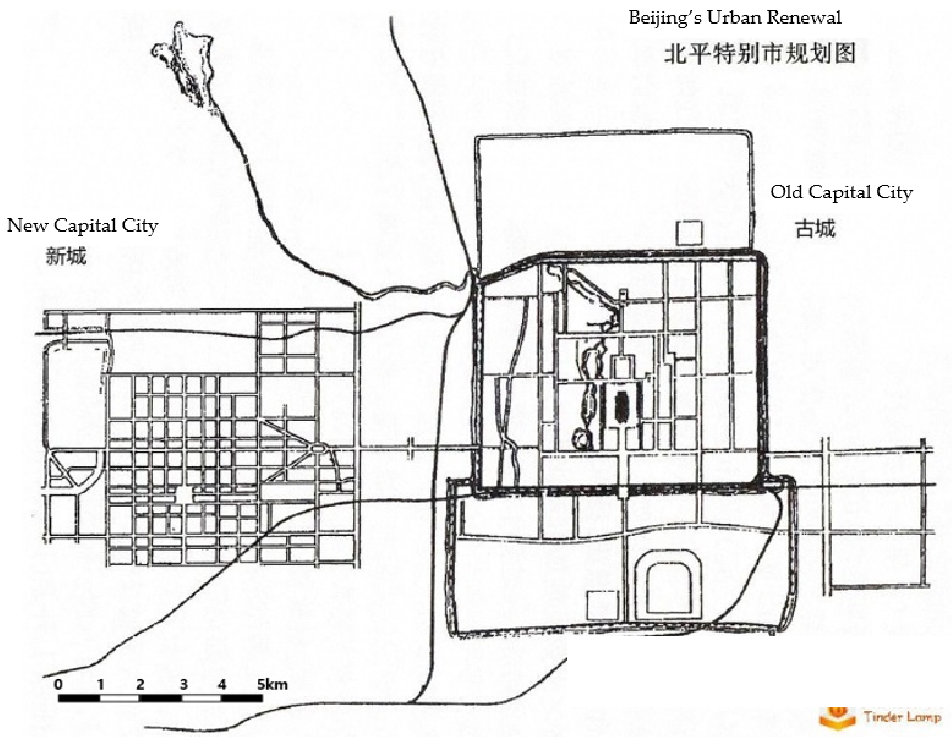
The most distinctive feature of the Beijing Urban Planning Outline was that it was a new city-centered plan. Instead of the old city center, it focused on building new cities in western suburbs focused on administrative and residential functions and eastern suburbs designated as industrial districts. Meanwhile, it only emphasized the preservation of historical places or the maintenance of urban functions inside the city walls. For the construction of western and eastern suburbs, it was planned to build new cities away from the existing city, not to expand the old city center in Beijing [
14,
15].
As the war intensified, subsequent plans were put on hold. Nonetheless, the Beijing City Government continued to be successful in building new cities in western and eastern suburbs in the post-war period.
3.3.2. Applicable Building Codes
On 1 October 1940, the General Office of Construction announced the Urban Construction Tentative Rules and designated the rules governing zoning, building lines, and building form regulations.
4. Urban Planning Comparison
Beginning with Japan, modern urban planning proceeded with Taipei, Seoul, and Beijing, which were colonized by Japan, based on Tokyo’s urban planning but with some updates and modifications. The present study compares the cities by each item from urban renewal to city planning law.
In
Table 1, the light gray represents major events in city plan revision, while the dark gray highlights major events in city planning legislation. The introduction of the Urban Planning Act occurred in the order of Tokyo, Taipei, and Kyungsung, with Beijing being introduced later due to the delay in occupation. In regard to urban renewal, Taipei was ahead of Kyungsung, but ultimately, the City Planning Law indicates that Joseon was quicker.
Table 1 illustrates where Japan’s focus on urban planning was in East Asia during each period.
The purpose of urban renewal varies across the cities, and Tokyo’s urban renewal was planned to facilitate the city’s fire protection measures, sanitation, and transport convenience. Among the colonized cities, urban renewal was taking place at the fastest pace in Taipei, where it originally began with sanitation issues (
Table 2).
In Seoul, urban renewal was planned to provide transport convenience and create the outer look of a modern city. The Urban Renewal Committee, an organization for planning, was established in Tokyo in 1885, Taipei in 1898, and Seoul in 1921. In Taipei, sanitation issues such as pests emerged as one of the biggest problems. Gotō invited Burton to give advice on sanitation works and urban renewal was implemented, focusing on water and sewage works. One of the notable features of Taipei’s urban renewal was that it was implemented from the 1st to the 6th Plan from 1895 to 1932. In addition, it began as a plan for water and sewage works and had expanded into road network and downtown expansion (
Table 2).
Seoul’s urban renewal was divided depending on who planned urban renewal into the one implemented by the Resident-General and the other by the Government-General. Furthermore, as urban renewal progressed, the City Planning Ordinance was planned at the same time. When planning urban renewal, all these four cities had a limitation that they reviewed the building code but did not include it (
Table 2).
The committee for the city planning law was established in each of the cities: Tokyo in 1919, Seoul in 1933, Taipei in 1934, and Beijing in 1938. During this period, their city planning law included the building code. Tokyo’s City Planning Law was led by Gotō, who initiated urban renewal in Taipei. Seoul’s urban planning was led by the Resident-General, the Government-General, or the Inspector-General of Political Affairs. It is worth noting that Inspector-General Shirou Ikegami of Political Affairs formerly served as Osaka Mayer and led urban planning in Osaka (
Table 2).
Hence, Tokyo’s urban planning and that of Taipei, Seoul, and Beijing cities, colonized by Japan, influenced each other when they were established, as the people in charge were intertwined and involved in multiple cities [
33].
5. Changing the Shapes of Traditional Cities through Modern Urban Planning Tokyo
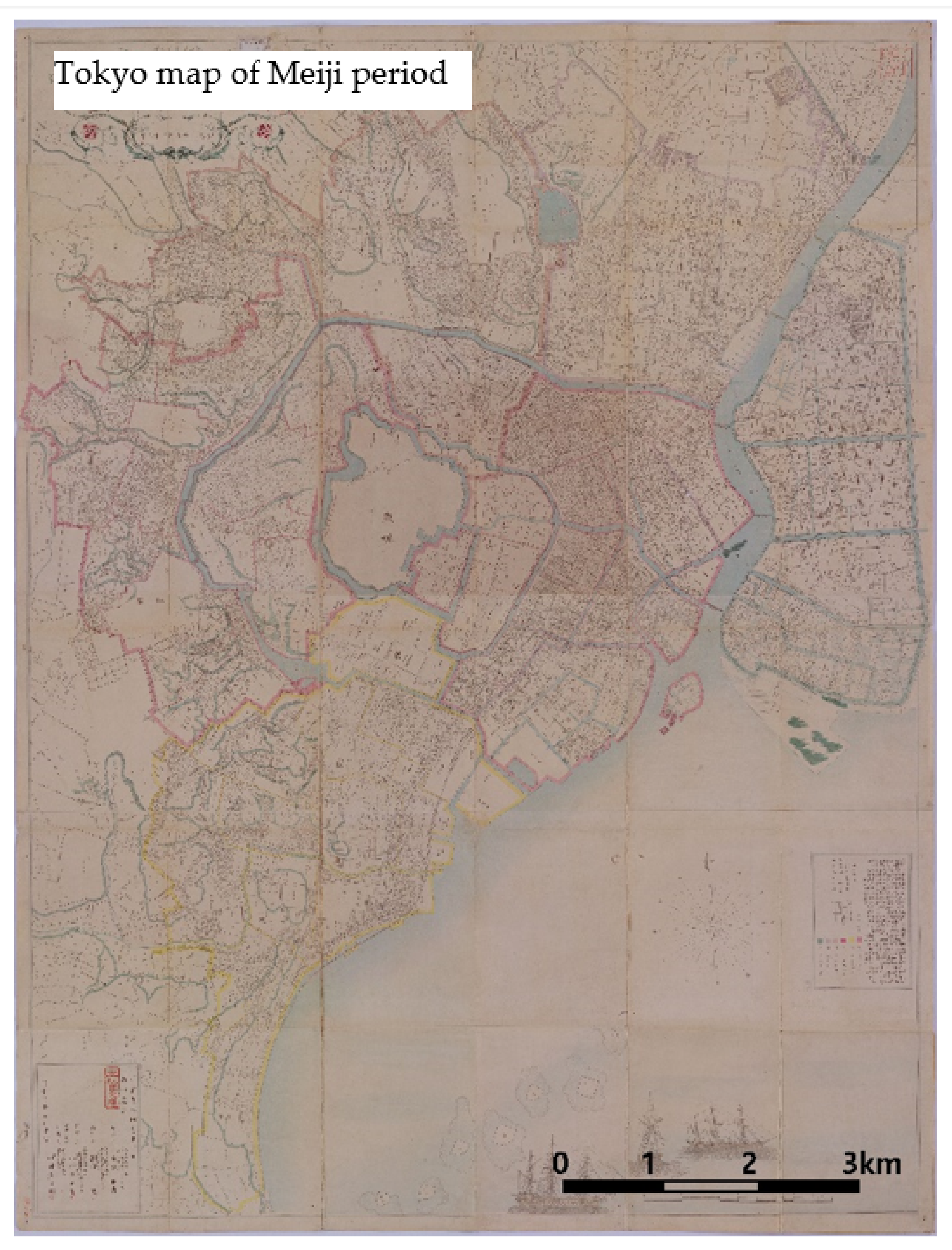
Edo, a predecessor of Tokyo, was part of Musashi Province. Edo Castle was built in 1457 during the mid-Muromachi period, laying the ground for the city of Edo. Afterwards, as Tokugawa Ieyasu entered Edo in 1590 and established the bakuhan system in 1603, Edo was planned as a large jōkamachi (castle town) in response to the class system and economic activity in the feudal period (
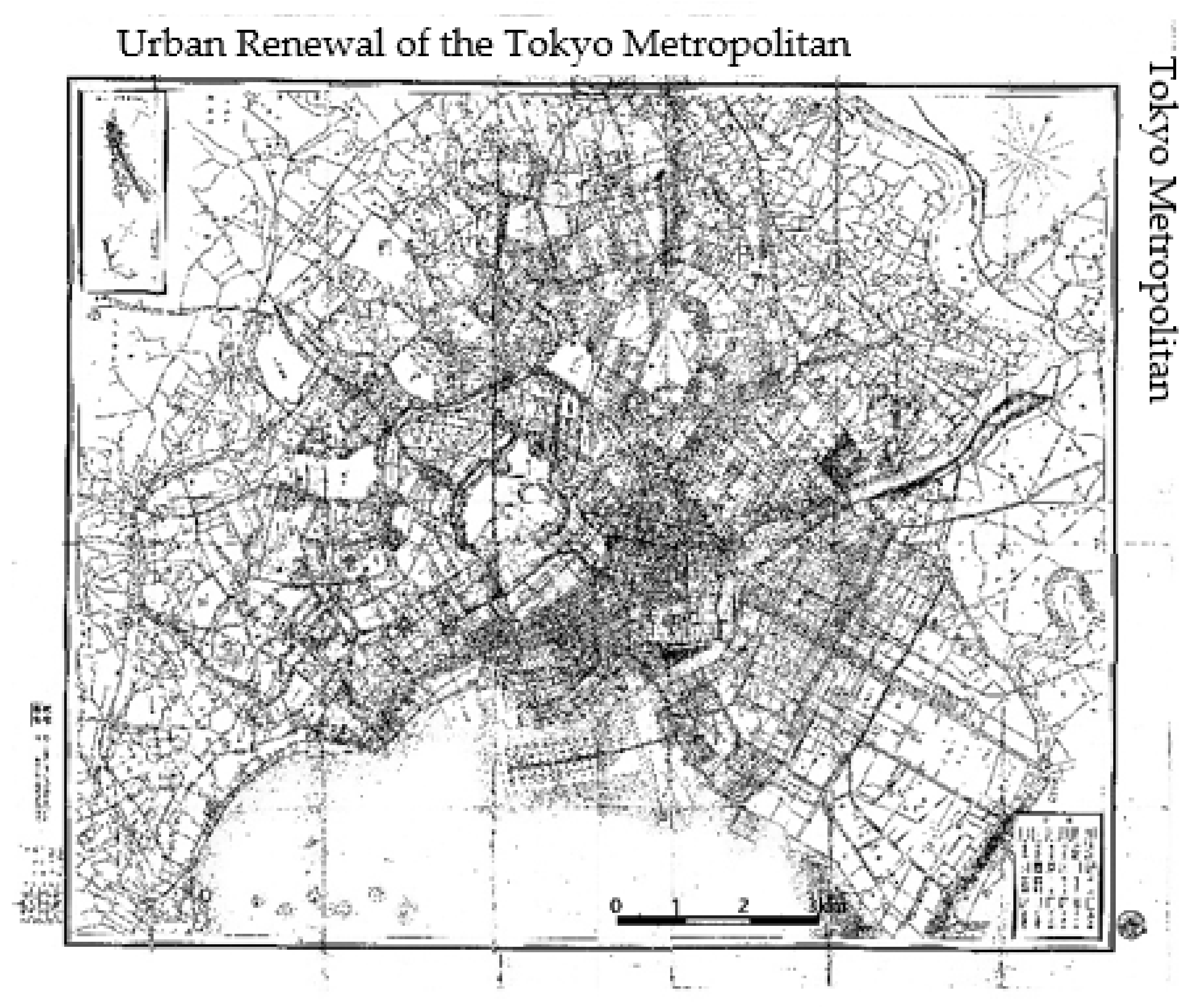
Figure 3). In the modern period, the Meiji government began to reshape Tokyo to ensure its reputation as a capital, prevent infectious diseases and large fires, and revamp transport facilities. With the Government Agency Focus Plan and the Ginja Brick Street Plan, Tokyo Urban Renewal, its first statutory urban planning, was implemented from 1889 to 1916. While it did not make further progress due to lack of funding, roads were expanded in the city center to operate trams, waterworks were rebuilt, and the Hibiya Park was created (
Figure 4).
The scale of downtown Tokyo was not so different between the Edo period and the Meiji period. Land use in the Edo period was set by the class system, and transport means were limited to walking or litter. With urban renewal in the Meiji period, however, land use and transport means were transformed. Although the City Planning Law was announced in 1919, the progress in urban renewal projects was not significant. After the 1923 Great Kantō earthquake, Gotō rebuilt the city’s infrastructure, including land readjustment, streets, bridges, and parks in the Imperial City Redevelopment Project.
Modern urban planning had the most significant effect on changing urban spaces when the traditional city of Edo transitioned into the modern city of Tokyo. Such urban planning was not governed by law at the beginning but implemented as part of urban renewal projects. A series of such projects was closely related to transport facilities in Tokyo and had proactively changed urban spaces. In Tokyo, Shimbashi Station was created in 1872, and the railway between
Shimbashi and Yokohama was built. Before that, the primary transport system in Tokyo was represented by horse-drawn carriages. In 1882, the Tokyo Stagecoach Railway was established, and while demands and discussions for trams continued, a decision by the Urban Renewal Committee for the Electric Railway Establishment Plan for 29 lines was made quite late in 1900, which was more delayed than other cities, due to disputes over patents between companies. The Urban Renewal Committee reduced streets planned for urban renewal, introduced the system that imposed tram railway project costs on the electric railway company, and completed most of the tram network by 1910. In addition, the fact that the city street plan was expanded in 1912, along with tram network expansion, confirms that urban planning at that time had been changing the city in response to a new transport system.
5.1. Taipei (1895~1945)
Taiwan City Walls were built by traditional norms such as feng shui geomancy and Chinese Royal Records. Before Japan came to rule the city, downtown Taipei consisted of three areas: Monga, where a cluster of houses were formed in the 18th century, Dadaocheng, established in the 19th century, and the inside of the city walls whose construction began in 1879. The Qing dynasty, which was threatened by Japan’s military advances in Taiwan, divided Taiwan Prefecture, which was the only prefecture established in Tainan, and created Taipei Prefecture. It built the administrative complex between the economically prospering Monga and Dadaocheng and constructed the walls to create Taipei City Walls. During Japanese colonial rule, Taipei faced the largest challenges of sanitation conditions in downtowns, including pests, and urban renewal was realized to improve the situation. Taipei’s urban renewal mostly addressed the inside of the city walls and primarily designed water and sewage works. The planned street network was based on the extension or standardization of existing streets. In Monga and Dadaocheng, existing roads were used as much as possible for renewal (
Figure 5).
With the opening of the Keelung-Hsinchu railway, Taipei Station was built in 1891. Taipei Station was located north of the city walls and south of Dadaocheng. The railway line ran from the west of the city walls through Monga in 1901. Taipei’s urban planning focused on sewage works in the first and second urban renewal plans and planned the city walls and south and east areas outside the city walls in the third and fourth plans. It was in 1905 that the city planned to connect the inside of the city walls, Dadaocheng, and Monga. Then, the Great Taipei Urbanization Plan aimed at connecting the inside of the city walls as well as traditional housing clusters in Dadaocheng and Monga, and expanding the city walls eastwards.
5.2. Seoul (1910~1945)
Hanyang (Seoul), which was designated as a capital of Joseon, was established using traditional urban planning ideas of Feng Shui geomancy, China’s city wall planning norm Chinese Royal Records, and considering the natural environment, including the original topography and terrain. Feng Shui geomancy had a significant effect on the decision to select Hanyang as a capital and the location of Gyeongbokgung, the royal palace. Around the palace, the locations of other major buildings such as shrines, ritual sites, and government offices followed the principles of ‘shrines on the left, ritual sites on the right, government offices on the front, and markets on the back’ in Chinese Royal Records. The palace was not located in the middle but north, and market stores were built in front of the palace. The modernization of Joseon’s capital Seoul began after the opening of ports in 1876. Since he took royal refuge at the Russian legation in 1896, King Gojong had implemented the Urban Rebuilding Project around Gyeongun-gung during the Korean Empire (
Figure 6).
After Japan won the Russo–Japanese War in 1904 and signed the Eulsa Treaty, the effective power of the Korean Empire was transferred to the Resident-General. From 1907, the Resident-General began to reshape spaces in Seoul. With Gyeongseong Prefecture Urban Renewal during the Resident-General period, Seoul’s urban renewal established a straight road connecting Donhwamun, Gwanghwamun, Daehanmun, and Namdaemun, which ran through Gyeongbokgung, a visual focus in the spatial structure of fortress walls, and Gyeongun-gung, which emerged as a new visual focus with the Urban Rebuilding Project during the Korean Empire period [
34]. Afterwards, the 1912 urban renewal plan, implemented by the Government-General, focused on turning Seoul’s urban organization into a grid shape. When it came to the responsible organization and funding, the Gyeongseong Civil Works Office implemented urban renewal, directly under the Department of Civil Works of the Regional Bureau of the Government-General, and then transferred to Gyeongseong Prefecture. For funding, until the urban renewal plan was announced in 1912, road paving funds from the Government-General were used, but afterwards, funds were secured by selling government properties.
Japan established urban planning in 1919, which affected Seoul, and discussions on urban planning were held in the city as well. The most central figure was Inspector-General Mizuno Rentarō of Political Affairs, who was elected in August 1919 along with Governor-General Saitō. Mizuno had a deep personal relationship with Gotō Shinpei and served as a director in the Imperial City Redevelopment Institute after the Great Kantō earthquake. During this period, the Gyeongseong Urban Planning Research Association was organized, and the draft of Seoul urban renewal plan was completed in 1925 but did not include benefit principles. In the fortress walls of Seoul, sections connecting the Japanese Army Garrison in Yongsan were rebuilt, and as a result, the downtown tended to expand towards Yongsan (
Figure 7).
In Seoul, the tram railway was built in 1898. Urban renewal implemented since Japanese colonial rule was planned to sort out roads in line with the tram network. Like Tokyo, modern urban planning was established with the construction of major transport facilities in mind, as transport convenience was one of the most important pillars in the city.
5.3. Beijing (1936~1945)
Beijing served as a capital as in ‘zhongdu (central capital)’ for the Jin dynasty (1115–1234) and ‘dadu (big capital)’ for the Yuan dynasty (1271–1368). Beijing was built under the principles of castle planning in Chinese Royal Records. With the emperor’s residence at the center, fields, additional palaces, roads, streams, and bridges were connected organically across the entire Beijing (Zhu, 2006). After the Qing dynasty’s feudal monarchy crumbled due to the Xinhai Revolution, urban renewal and construction began in Beijing.
The Beiyang government (1912–1928) created the Capital Urban Renewal Office, which took charge of urban planning and construction in Beijing, and turned facilities related to the emperor in the Qing dynasty into public spaces. In addition, streets, gates, and walls were renovated to allow for vehicle traffic. With the Manchurian Incident in 1931, Japan occupied Northeast China and took over Beiping in 1937 (its name was changed to Beijing in April 1938). In December 1937, Japan established the Provisional Government of the Republic of China in Beijing and the North China Political Affairs Commission in March 1940. At that time, Beijing functioned as a capital for the regime in North China and played an important role to allow Japan to form a colonial stronghold. The population grew fast after Japan took over Beijing, and there were growing needs for urban planning in response to the population growth. In Beijing, the area in which the city walls used to be was designated as the old city center, and new cities were built westwards instead of expanding the old city center (
Figure 8).
6. Conclusions
Tokyo started urban renewal quite early in 1876 to present itself as the modern capital of Japan. Plans and revisions for urban renewal were presented before establishing the Urban Renewal Plan in 1914. While the planning for urban renewal was discussed primarily for Tokyo, the implementation of urban renewal plans was carried out in a similar period also in other colonized cities. Tokyo enacted the City Planning Law for the first time in 1919 and revised it in 1933. The City Planning Law for each city under colonial rule was discussed and introduced based on it. In 1940, Seoul had a population of 940,000 people, Taipei 330,000, and Beijing 1.6 million, and along with urban scale problems, the timing of urban planning and the existence of the old city walls made a difference in each city’s planning. What Tokyo, Seoul, Beijing, and Taipei had in common was that they were all centered on the existing city walls.
This study aimed to examine the conclusions drawn about modern city planning, its timing of implementation, and its effect in several cities. The study found that the establishment of organizations for decision-making and implementation preceded urban renewal projects in all cities.
Firstly, urban renewal projects and city planning laws were carried out in different cities. It mentions that each city established an organization for decision-making and implementation prior to urban renewal projects, and the timing of these organizations varied among the cities.
The sewerage networks were planned by experts in sewage planning, while other city planning was led by administrators. In the colonial cities of Taipei and Seoul, urban renewal was led by the Government-General, while in Tokyo and Beijing, the respective government agencies were responsible for urban planning. In Tokyo, the Tokyo Urban Renewal Review Committee was established in the Home Ministry in 1885, and the Tokyo Urban Renewal Committee was created in 1888. The City Planning Law Implementation Preparation Committee was established by the Government-General of Taiwan in 1934. In Seoul, the Urban Planning Research Association was established in 1928, and the Kyungseong Urban Planning Survey Committee was organized in 1933. Japan took over Beijing in 1937 and the General Office of Construction was established in the North China Political Affairs Commission in 1938, with the City Bureau thereunder to push for urban planning. While the timing was different, the establishment of organizations to plan urban renewal and the city planning law went ahead in a similar pattern in colonized cities. With respect to planners, although an expert was invited to plan sewage works, urban planning for other works was carried out by administrators in the cities. The urban planning in Taipei and Seoul was led by the Resident-General or Governor-General appointed at that time.
Secondly, the implementation of urban renewal and the City Planning Ordinance among several cities was carried out in the following order: First, urban renewal was planned for Tokyo, but it was actually applied in Taipei before Tokyo. Taipei underwent urban renewal before other cities, and its street system was based on the grid-iron design. Meanwhile, the City Planning Ordinance was first planned and implemented in Tokyo and later spread to other colonized cities during a similar period.
Thirdly, the effects of urban renewal and the City Planning Ordinance in each city were similar in that they started by rebuilding the old city walls and then shifted their focus to expanding the city and suburban areas. Tokyo renovated Edo, which was a traditional city, through Urban Renewal Plan, and it was expanded to the west, south, and north of Edo through the City Planning Law. The Great Taipei Urbanization Plan aimed at connecting the inside of the city walls as well as traditional housing clusters in Dadaocheng and Monga and expanding the city walls eastwards. Seoul renovated the traditional city through Urban Renewal Plan, and the expansion of the new urban area tended to expand towards Yongsan and Yeongdeungpo area (southwest). In Beijing, the area in which the city walls used to be was designated as the old city center, and new cities were built westwards instead of expanding the traditional city (
Figure 9).
Finally, the urban renewal project and City Planning Ordinance in each city had different characteristics: Taipei aimed to integrate sewage systems and streets and built a new downtown on top of the old one, which was destroyed by a natural disaster, with Japanese financial support. Tokyo aimed to integrate sewage systems and streets as well, but it did not happen as planned due to financial difficulties and disasters. Instead, it focused on rebuilding roads within the existing urban structure. Seoul’s sewage works were developed independently of streets as a result of rebuilding small streams. The plan prioritized preserving the existing city, but due to funding constraints, it focused on rebuilding the existing downtown through land readjustment. It had a longer history of discussions and survey activities for urban planning due to a longer colonial rule. Beijing planned for new cities and placed greater emphasis on preserving the old city walls, leaving the urban structure unchanged. It relatively overlooked the old city walls.


