


Coupling Coordination Degree between Ecological Environment Quality and Urban Development in Chengdu–Chongqing Economic Circle Based on the Google Earth Engine Platform
Abstract
:1. Introduction
2. Study Area and Data Sources
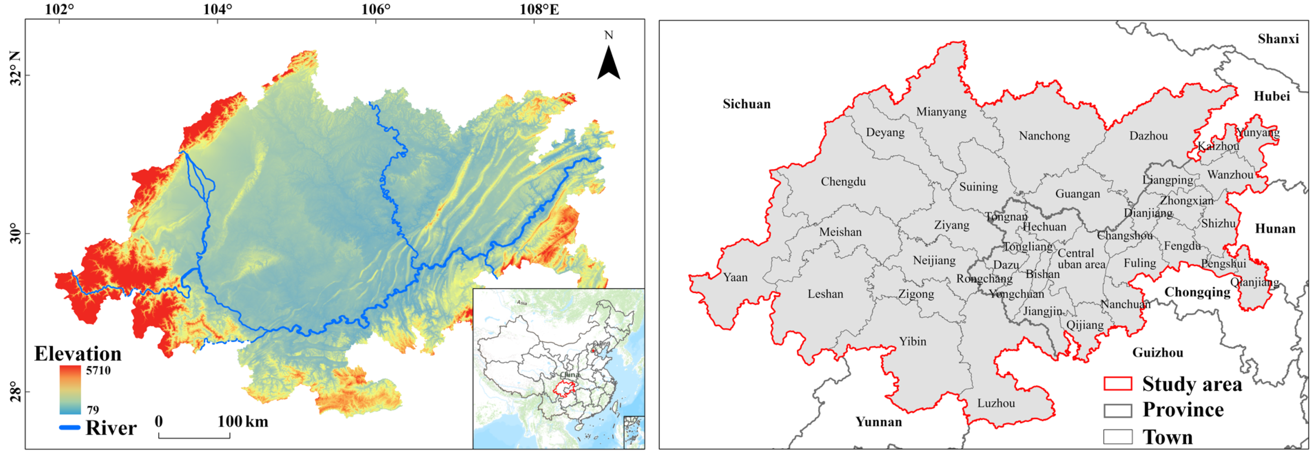
2.1. Study Area
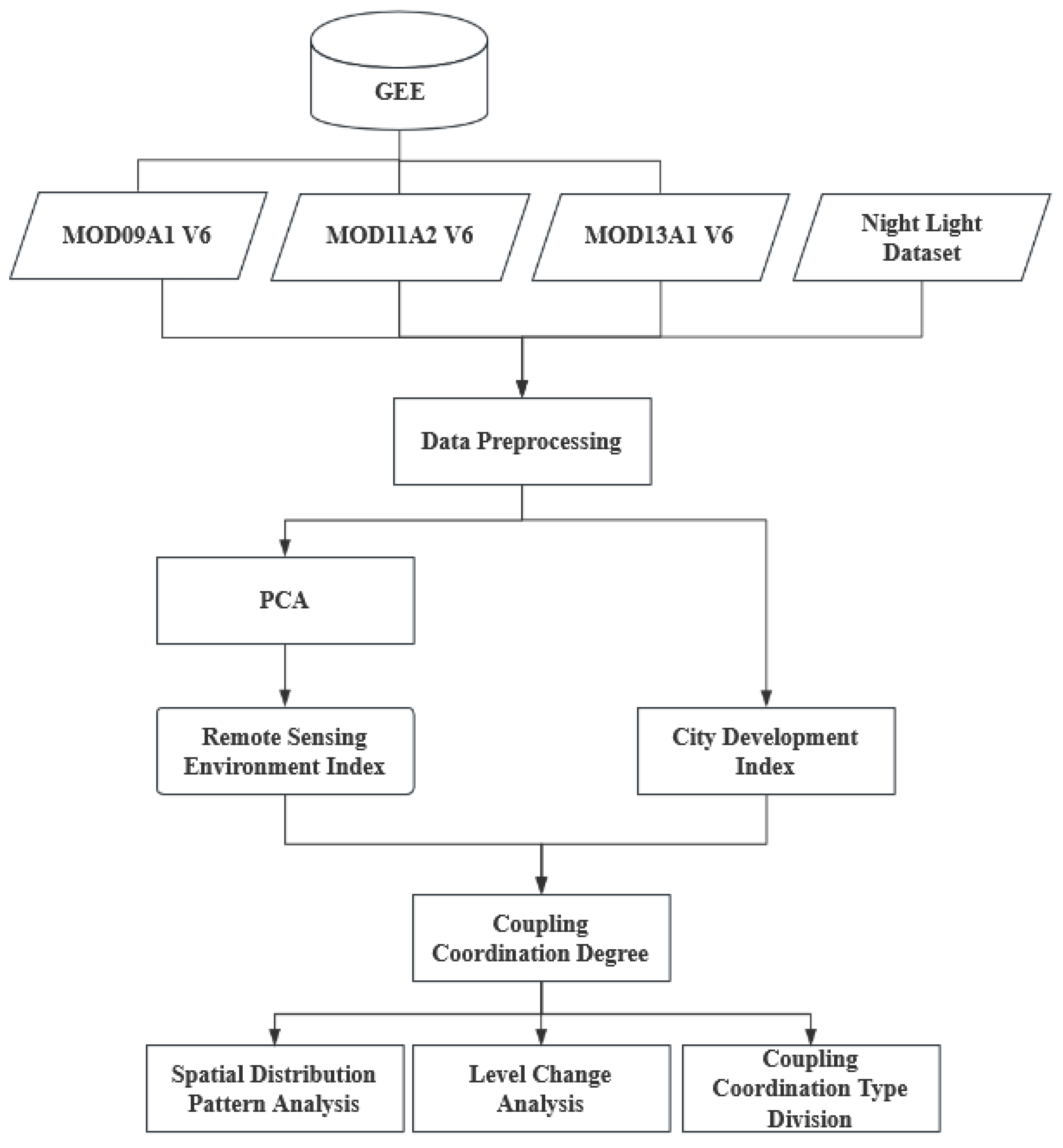
2.2. Data Sources

| Sources | Dataset | Spatial Resolution | Description |
|---|---|---|---|
| Google Earth Engine | The National Aeronautics and Space Administration Digital Elevation Model (NASADEM) | 30 m | Reprocessed Shuttle Radar Topography Mission (SRTM) data that offers improved accuracy over the original terrain data. |
| MOD09A1 V6 | 500 m | Terra MODIS surface reflectance data. | |
| MOD11A2 V6 | 1000 m | 8-day average synthetic surface temperature. | |
| MOD13A1 V6 | 500 m | The Normalized Difference Vegetation Index (NDVI) and the Enhanced Vegetation Index (EVI) vegetation index products. | |
| A Big Earth Data Platform for Three Poles | A Prolonged Artificial Nighttime-Light Dataset of China (1984–2020) [28] | 1000 m | Annual artificial night light data from China. |
3. Methods
3.1. RSEI Construction
3.2. Coupling Coordination Model
3.3. Markov Chain
4. Results
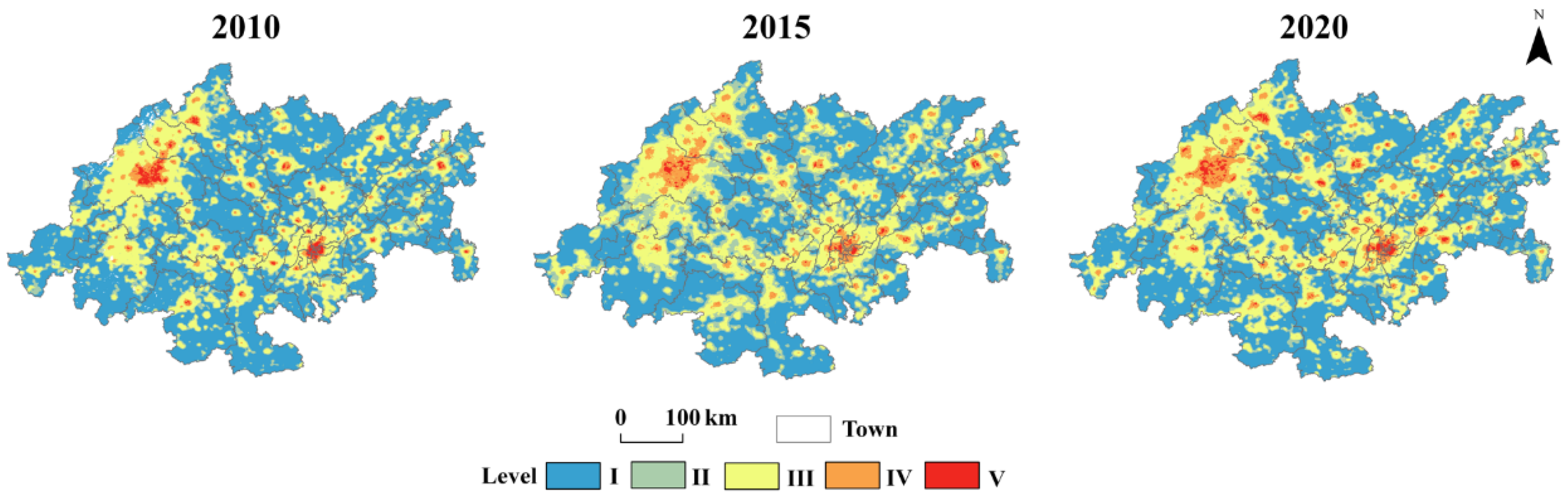
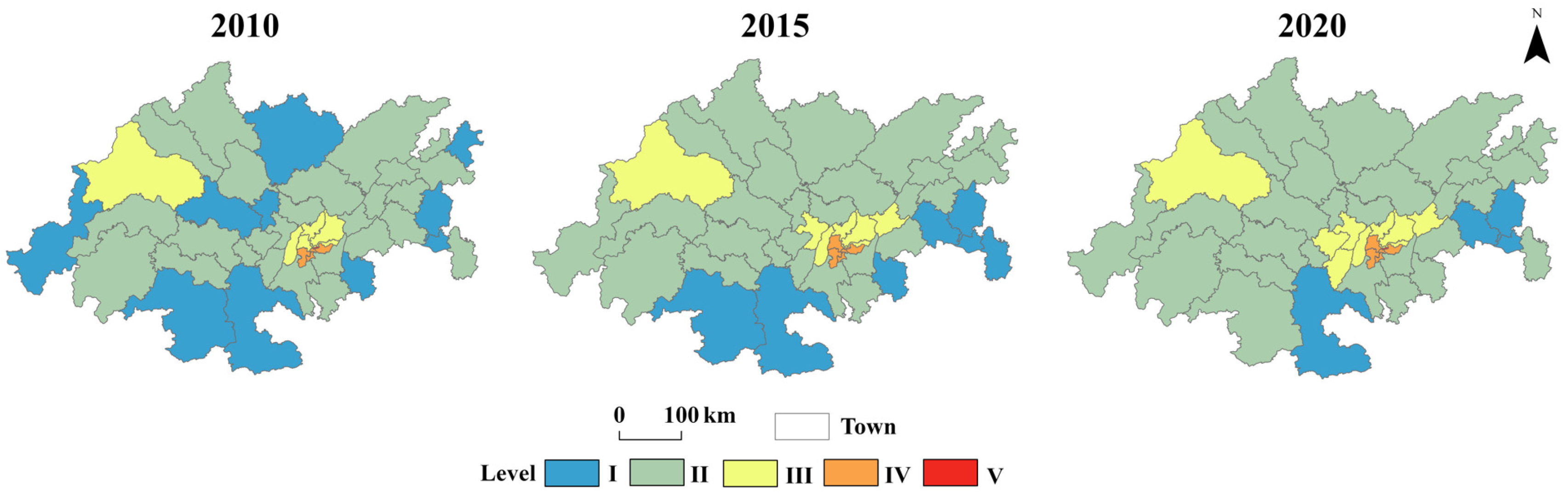
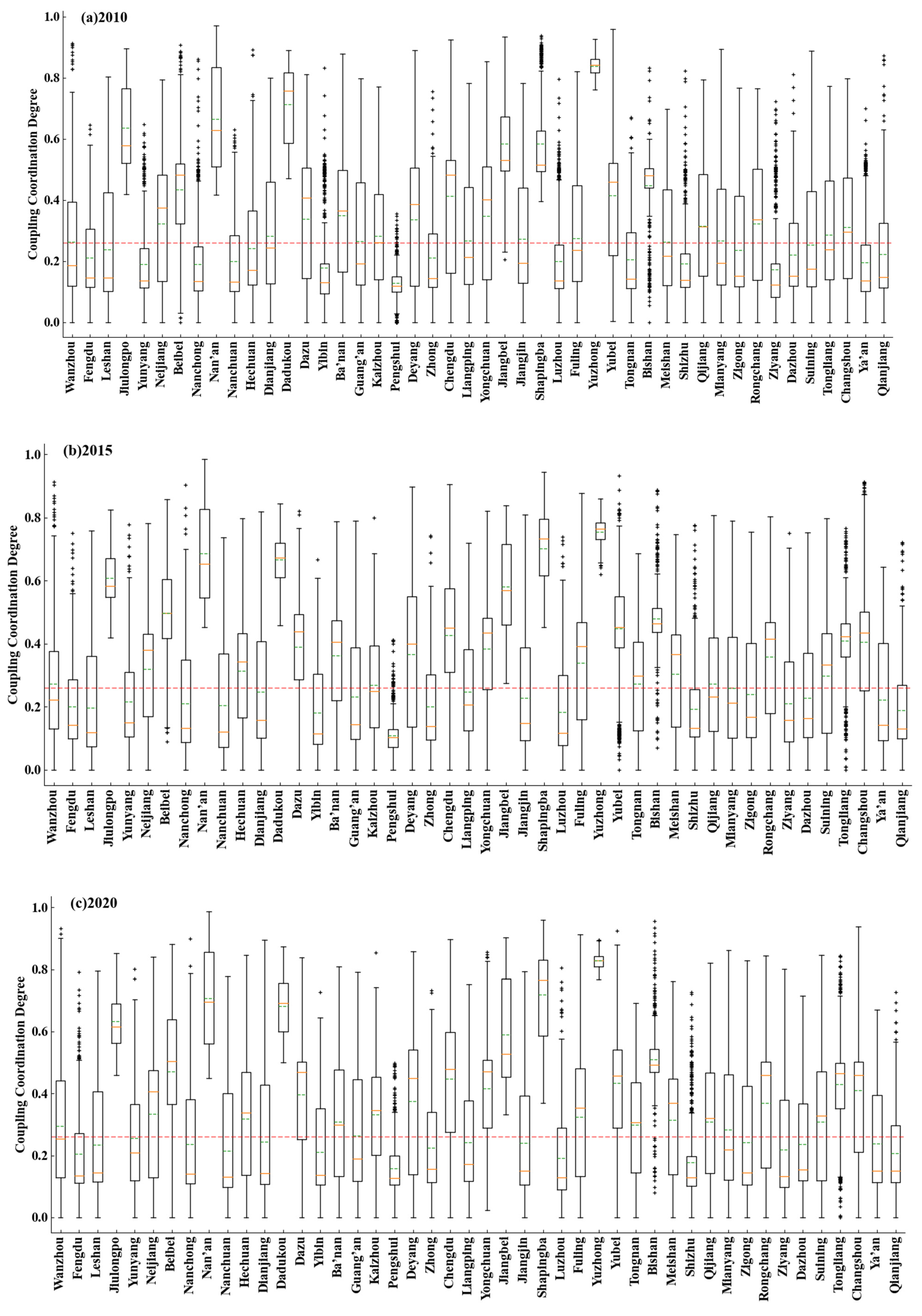
4.1. Spatial Distribution Pattern Analysis
4.2. Level Change Analysis
- (1)
- The elements on the main diagonal of Table 3 are larger than the off-diagonal elements, indicating that the coupling coordination level has stability and dependence;
- (2)
- The off-diagonal elements in Table 3 decrease rapidly with distance from the main diagonal, indicating that the level changes for the coupling coordination are mainly active in the adjacent levels, and there is limited skipping between the levels. The weighted probability of a rise between the adjacent levels near the main diagonal is 0.143, which is higher than the probability of a level drop, which is 0.097;
- (3)
- Level rise mainly occurs between levels I and II, and the probability of transition from II to III is the highest, with a probability of 0.251. Decreases between the levels mainly occurred under two marginal conditions, namely, levels II and V, reaching the values of 0.331 and 0.524, respectively, in Table 3. According to Figure 3, this indicates that rapid development of the urban economy was concentrated in undeveloped regions and in highly developed regions, which caused the varying change of the levels in these regions.
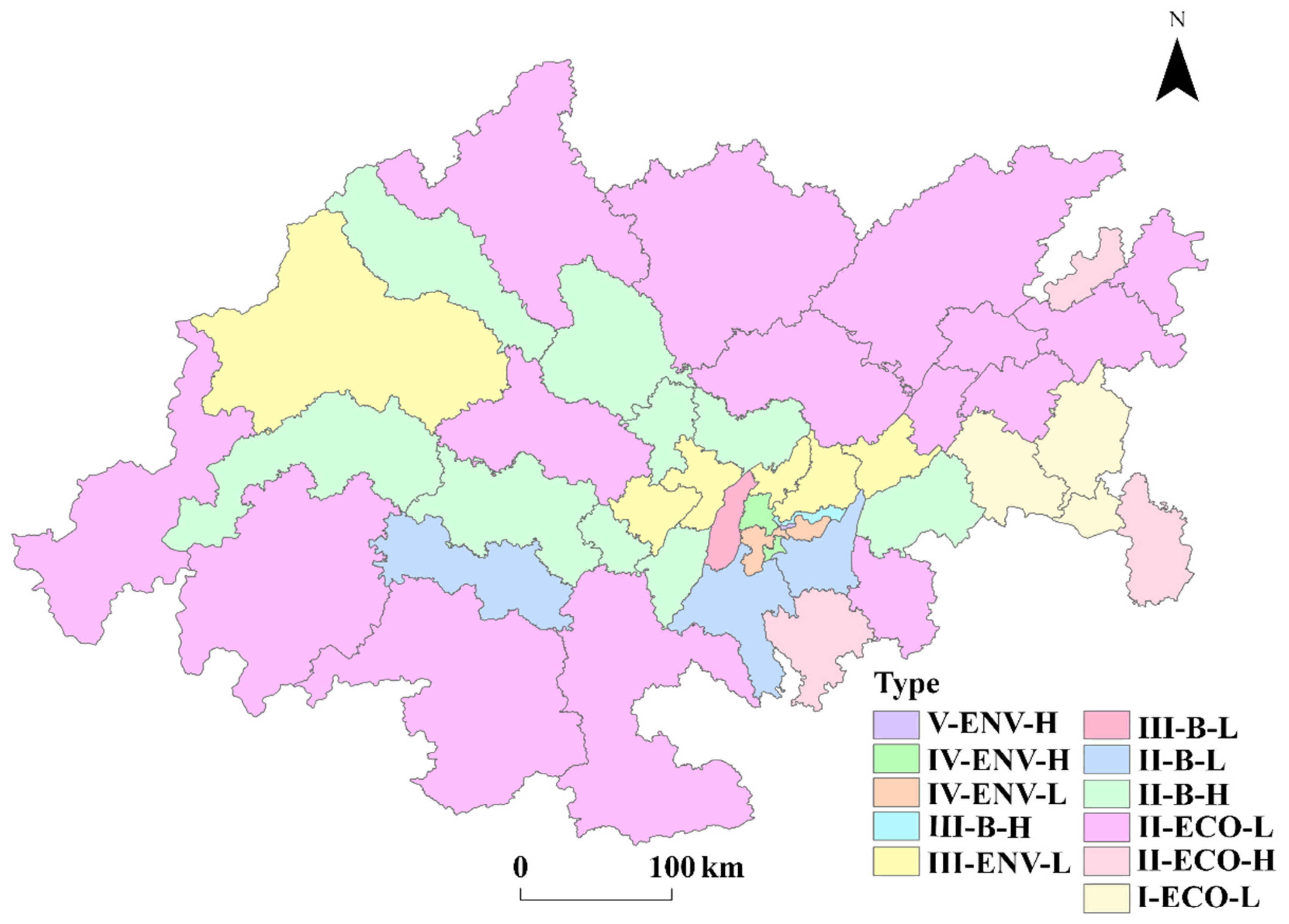
4.3. Coupling Coordination Type Division
5. Discussion
6. Conclusions
Author Contributions
Funding
Data Availability Statement
Conflicts of Interest
References
- Tonne, C.; Adair, L.; Adlakha, D.; Anguelovski, I.; Belesova, K.; Berger, M.; Brelsford, C.; Dadvand, P.; Dimitrova, A.; Giles-Corti, B.; et al. Defining pathways to healthy sustainable urban development. Environ. Int. 2021, 146, 106236. [Google Scholar] [CrossRef]
- Fang, C.; Yu, D. Urban agglomeration: An evolving concept of an emerging phenomenon. Landsc. Urban Plan. 2017, 162, 126–136. [Google Scholar] [CrossRef]
- Liang, W.; Yang, M. Urbanization, economic growth and environmental pollution: Evidence from China. Sustain. Comput. Inform. Syst. 2019, 21, 1–9. [Google Scholar] [CrossRef]
- Rahman, M.M.; Alam, K. Clean energy, population density, urbanization and environmental pollution nexus: Evidence from Bangladesh. Renew. Energy 2021, 172, 1063–1072. [Google Scholar] [CrossRef]
- Moreno, C.; Allam, Z.; Chabaud, D.; Gall, C.; Pratlong, F. Introducing the “15-Minute City”: Sustainability, resilience and place identity in future post-pandemic cities. Smart Cities 2021, 4, 93–111. [Google Scholar] [CrossRef]
- Belli, L.; Cilfone, A.; Davoli, L.; Ferrari, G.; Adorni, P.; Di Nocera, F.; Dall’Olio, A.; Pellegrini, C.; Mordacci, M.; Bertolotti, E. IoT-enabled smart sustainable cities: Challenges and approaches. Smart Cities 2020, 3, 1039–1071. [Google Scholar] [CrossRef]
- Zuo, Z.; Guo, H.; Cheng, J.; Li, Y. How to achieve new progress in ecological civilization construction?—Based on cloud model and coupling coordination degree model. Ecol. Indic. 2021, 127, 107789. [Google Scholar] [CrossRef]
- Ariken, M.; Zhang, F.; Chan, N.w.; Kung, H.t. Coupling coordination analysis and spatio-temporal heterogeneity between urbanization and eco-environment along the Silk Road Economic Belt in China. Ecol. Indic. 2021, 121, 107014. [Google Scholar] [CrossRef]
- Zhang, Y. Research on Coupling and Coordinated Development of Urbanization and Eco-Environment in Chengdu-Chongqing Economic Circle. Master’s Thesis, Chongqing University, Chongqing, China, 2021. (In Chinese). [Google Scholar]
- Wang, C.; Tang, N. Spatio-temporal characteristics and evolution of rural production living-ecological space function coupling coordination in Chongqing Municipality. Geogr. Res. 2018, 37, 1100–1114. (In Chinese) [Google Scholar]
- Zhao, J.; Liu, Y.; Zhu, Y.; Qin, S.; Wang, Y.; Miao, C. Spatiotemporal differentiation and influencing factors of the coupling and coordinated development of new urbanization and ecological environment in the Yellow River Basin. Resour. Sci. 2020, 42, 159–171. (In Chinese) [Google Scholar] [CrossRef]
- Wang, D.; Sun, F. Geographic Patterns and Coupling-coordination Between Urbanization and Land Transportation Accessibility in the Yangtze River Economic Zone. Sci. Geogr. Sin. 2018, 38, 1089–1097. (In Chinese) [Google Scholar]
- Firozjaei, M.K.; Fathololoumi, S.; Kiavarz, M.; Biswas, A.; Homaee, M.; Alavipanah, S.K. Land Surface Ecological Status Composition Index (LSESCI): A novel remote sensing-based technique for modeling land surface ecological status. Ecol. Indic. 2021, 123, 107375. [Google Scholar] [CrossRef]
- Wu, H.; Guo, B.; Fan, J.; Yang, F.; Han, B.; Wei, C.; Meng, C. A novel remote sensing ecological vulnerability index on large scale: A case study of the China-Pakistan Economic Corridor region. Ecol. Indic. 2021, 129, 107955. [Google Scholar] [CrossRef]
- Xu, H. A remote sensing index for assessment of regional ecological changes. China Environ. Sci. 2013, 33, 889–897. (In Chinese) [Google Scholar]
- Tang, H.; Fang, J.; Xie, R.; Ji, X.; Li, D.; Yuan, J. Impact of Land Cover Change on a Typical Mining Region and Its Ecological Environment Quality Evaluation Using Remote Sensing Based Ecological Index (RSEI). Sustainability 2022, 14, 12694. [Google Scholar] [CrossRef]
- Yuan, B.; Fu, L.; Zou, Y.; Zhang, S.; Chen, X.; Li, F.; Deng, Z.; Xie, Y. Spatiotemporal change detection of ecological quality and the associated affecting factors in Dongting Lake Basin, based on RSEI. J. Clean. Prod. 2021, 302, 126995. [Google Scholar] [CrossRef]
- Zheng, Z.; Wu, Z.; Chen, Y.; Guo, C.; Marinello, F. Instability of remote sensing based ecological index (RSEI) and its improvement for time series analysis. Sci. Total Environ. 2022, 814, 152595. [Google Scholar] [CrossRef]
- Andreano, M.S.; Benedetti, R.; Piersimoni, F.; Savio, G. Mapping poverty of Latin American and Caribbean countries from heaven through night-light satellite images. Soc. Indic. Res. 2021, 156, 533–562. [Google Scholar] [CrossRef]
- Mellander, C.; Lobo, J.; Stolarick, K.; Matheson, Z. Night-time light data: A good proxy measure for economic activity? PLoS ONE 2015, 10, e0139779. [Google Scholar] [CrossRef] [Green Version]
- Wang, Y.; Liu, Z.; He, C.; Xia, P.; Liu, Z.; Liu, H. Quantifying urbanization levels on the Tibetan Plateau with high-resolution nighttime light data. Geogr. Sustain. 2020, 1, 233–244. [Google Scholar] [CrossRef]
- Gorelick, N.; Hancher, M.; Dixon, M.; Ilyushchenko, S.; Thau, D.; Moore, R. Google Earth Engine: Planetary-scale geospatial analysis for everyone. Remote Sens. Environ. 2017, 202, 18–27. [Google Scholar] [CrossRef]
- Stefanidis, S.; Alexandridis, V.; Mallinis, G. A cloud-based mapping approach for assessing spatiotemporal changes in erosion dynamics due to biotic and abiotic disturbances in a Mediterranean Peri-Urban forest. Catena 2022, 218, 106564. [Google Scholar] [CrossRef]
- Tavakkoli Piralilou, S.; Einali, G.; Ghorbanzadeh, O.; Nachappa, T.G.; Gholamnia, K.; Blaschke, T.; Ghamisi, P. A Google Earth Engine approach for wildfire susceptibility prediction fusion with remote sensing data of different spatial resolutions. Remote Sens. 2022, 14, 672. [Google Scholar] [CrossRef]
- Nasiri, V.; Deljouei, A.; Moradi, F.; Sadeghi, S.M.M.; Borz, S.A. Land Use and Land Cover Mapping Using Sentinel-2, Landsat-8 Satellite Images, and Google Earth Engine: A Comparison of Two Composition Methods. Remote Sens. 2022, 14, 1977. [Google Scholar] [CrossRef]
- Xu, H. A Study on Information Extraction of Water Body with the Modified Normalized Difference Water Index (MNDWI). Natl. Remote Sens. Bull. 2005, 9, 589–595. (In Chinese) [Google Scholar]
- Li, T.; Guo, Z.; Ma, C. Dynamic Characteristics of Urbanization Based on Nighttime Light Data in China’s “Plain–Mountain Transition Zone”. Int. J. Environ. Res. Public Health 2022, 19, 9230. [Google Scholar] [CrossRef]
- Zhang, L.; Ren, Z.; Chen, B.; Gong, P.; Fu, H.; Xu, B. A Prolonged Artificial Nighttime-light Dataset of China (1984–2020); A Big Earth Data Platform for Three Poles; National Tibetan Plateau Data Center: Beijing, China, 2021. (In Chinese) [Google Scholar]
- Lobser, S.E.; Cohen, W.B. MODIS tasselled cap: Land cover characteristics expressed through transformed MODIS data. Int. J. Remote Sens. 2007, 28, 5079–5101. [Google Scholar] [CrossRef]
- Gong, P.; Li, X.C.; Zhang, W. 40-Year (1978–2017) human settlement changes in China reflected by impervious surfaces from satellite remote sensing. Sci. Bull. 2019, 64, 756–763. (In Chinese) [Google Scholar] [CrossRef] [PubMed] [Green Version]
- Xu, H. A remote sensing urban ecological index and its application. Acta Ecol. Sin. 2013, 33, 7853–7862. (In Chinese) [Google Scholar]
- Liao, C. Quantitative judgement and classification system for coordinated development of environment and economy—A case study of the city group in the Pearl River Delta. Trop. Geogr. 1999, 19, 171–177. [Google Scholar]
- Balzter, H. Markov chain models for vegetation dynamics. Ecol. Model. 2000, 126, 139–154. [Google Scholar] [CrossRef] [Green Version]
- Liang, L.; Wang, Z.; Fang, C.; Sun, Z. Spatiotemporal differentiation and coordinated development pattern of urbanization and the ecological environment of the Beijing-Tianjin-Hebei urban agglomeration. Acta Ecol. Sin. 2019, 39, 1212–1225. (In Chinese) [Google Scholar]
- Ma, Z.; Duan, X.; Wang, L.; Wang, Y. Study on Spatial Coupling Characteristics of Regional Development and Resource-Environment Carrying Capacity and Path of High-Quality Development in Yangtze River Economic Belt. Resour. Environ. Yangtze Basin 2022, 31, 1873–1883. (In Chinese) [Google Scholar]
- Chen, M.; Li, Z.; Duan, L.; Pu, X.; LÜ, P.; He, M.; Chen, J. Spatiotemporal Patterns and Key Driving Forces of lndustrial Air Pollutant Discharge in Chengdu-Chongqing Region. Res. Environ. Sci. 2022, 35, 1072–1081. (In Chinese) [Google Scholar]
- Li, X.; Long, X.; Qi, X. Dynamic Evolution and Analysis of Coupling Development of Economy, Society and Environment in Yangtze River Economic Belt. Resour. Environ. Yangtze Basin 2019, 28, 505–516. (In Chinese) [Google Scholar]
- Wan, J.; Li, Y.; Ma, C.; Jiang, T.; Su, Y.; Zhang, L.; Yang, J. Measurement of Coupling Coordination Degree and Spatio-Temporal Characteristics of the Social Economy and Ecological Environment in the Chengdu–Chongqing Urban Agglomeration under High-Quality Development. Int. J. Environ. Res. Public Health 2021, 18, 11629. [Google Scholar] [CrossRef]
- Zhang, X.; Jie, X.; Ning, S.; Wang, K.; Li, X. Coupling and coordinated development of urban land use economic efficiency and green manufacturing systems in the Chengdu-Chongqing Economic Circle. Sustain. Cities Soc. 2022, 85, 104012. [Google Scholar] [CrossRef]
- Yang, L.J.; Zhang, X.H.; Pan, J.H.; Yang, Y.C. Coupling coordination and interaction between urbanization and eco-environment in Cheng-Yu urban agglomeration, China. Ying Yong Sheng Tai Xue Bao J. Appl. Ecol. 2021, 32, 993–1004. [Google Scholar]
- Wang, J.; Li, G.; Chen, F. Eco-Environmental Effect Evaluation of Tamarix chinesis Forest on Coastal Saline-Alkali Land Based on RSEI Model. Sensors 2022, 22, 5052. [Google Scholar] [CrossRef]
- Zeng, C.; Song, Y.; Cai, D.; Hu, P.; Cui, H.; Yang, J.; Zhang, H. Exploration on the spatial spillover effect of infrastructure network on urbanization: A case study in Wuhan urban agglomeration. Sustain. Cities Soc. 2019, 47, 101476. [Google Scholar] [CrossRef]
- Cui, X.; Fang, C.; Liu, H.; Liu, X.; Li, Y. Dynamic simulation of urbanization and eco-environment coupling: Current knowledge and future prospects. J. Geogr. Sci. 2020, 30, 333–352. [Google Scholar] [CrossRef]
- Sodiq, A.; Baloch, A.A.; Khan, S.A.; Sezer, N.; Mahmoud, S.; Jama, M.; Abdelaal, A. Towards modern sustainable cities: Review of sustainability principles and trends. J. Clean. Prod. 2019, 227, 972–1001. [Google Scholar] [CrossRef]


| Indicator/Level of Coupling Coordination | 2010 | 2015 | 2020 |
|---|---|---|---|
| I (%) | 55.74 | 48.86 | 50.02 |
| II (%) | 15.50 | 20.87 | 15.92 |
| III (%) | 25.04 | 25.16 | 28.12 |
| IV (%) | 2.78 | 4.60 | 4.96 |
| V (%) | 0.93 | 0.50 | 0.97 |
| Average RSEI | 0.74 | 0.62 | 0.65 |
| Average night light | 305.38 | 426.86 | 439.24 |
| Average coupling coordination | 0.26 | 0.26 | 0.28 |
| Ratio | I | II | III | IV | V | |
|---|---|---|---|---|---|---|
| I | 52.30 | 0.820 | 0.151 | 0.029 | 0.000 | 0.000 |
| II | 18.19 | 0.331 | 0.417 | 0.251 | 0.001 | 0.000 |
| III | 25.10 | 0.021 | 0.115 | 0.802 | 0.060 | 0.001 |
| IV | 3.69 | 0.000 | 0.000 | 0.123 | 0.776 | 0.101 |
| V | 0.72 | 0.000 | 0.000 | 0.005 | 0.524 | 0.471 |
| Code (Town Number) | Code (Town Number) |
|---|---|
| V-ENV-H (1) | III-B-L (1) |
| IV-ENV-H (2) | II-B-L (3) |
| IV-ENV-L (2) | II-B-H (9) |
| III-ENV-L (1) | II-ECO-L (15) |
| III-B-H (6) | II-ECO-H (3) |
| I-ECO-L (3) |
Disclaimer/Publisher’s Note: The statements, opinions and data contained in all publications are solely those of the individual author(s) and contributor(s) and not of MDPI and/or the editor(s). MDPI and/or the editor(s) disclaim responsibility for any injury to people or property resulting from any ideas, methods, instructions or products referred to in the content. |
© 2023 by the authors. Licensee MDPI, Basel, Switzerland. This article is an open access article distributed under the terms and conditions of the Creative Commons Attribution (CC BY) license (https://creativecommons.org/licenses/by/4.0/).
Share and Cite
Zhang, J.; Zhou, T. Coupling Coordination Degree between Ecological Environment Quality and Urban Development in Chengdu–Chongqing Economic Circle Based on the Google Earth Engine Platform. Sustainability 2023, 15, 4389. https://doi.org/10.3390/su15054389
Zhang J, Zhou T. Coupling Coordination Degree between Ecological Environment Quality and Urban Development in Chengdu–Chongqing Economic Circle Based on the Google Earth Engine Platform. Sustainability. 2023; 15(5):4389. https://doi.org/10.3390/su15054389
Chicago/Turabian StyleZhang, Jiajie, and Tinggang Zhou. 2023. "Coupling Coordination Degree between Ecological Environment Quality and Urban Development in Chengdu–Chongqing Economic Circle Based on the Google Earth Engine Platform" Sustainability 15, no. 5: 4389. https://doi.org/10.3390/su15054389