Article

An Effective Precision Afforestation System for UAV

1
Institute for Public Safety Research, Department of Engineering Physics, Tsinghua University, Beijing 100084, China
2
The Key Laboratory of Marine Environmental Survey Technology and Application, Ministry of Natural Resources, Guangzhou 510300, China
*
Author to whom correspondence should be addressed.
Sustainability 2023, 15(3), 2212; https://doi.org/10.3390/su15032212
Submission received: 13 December 2022 / Revised: 16 January 2023 / Accepted: 18 January 2023 / Published: 25 January 2023
(This article belongs to the Special Issue Managing Forest and Plant Resources for Sustainable Development)

Abstract

:
Much agricultural and forestry land in the world cannot be accessed by ground planting equipment because of traffic, terrain, and other factors. This not only causes low efficiency and waste of resources, but also has a negative impact on the sustainable development of forestry. Therefore, it is significant to develop an accurate, efficient, and energy-saving aerial precision seeding system using unmanned aerial vehicle (UAV) technology to meet the actual needs of forestry planting. In this study, a UAV precision afforestation system with a GUI, afforestation UAV, positioning system, and information interaction system were developed using related approaches such as electronic information technology. The UAV airborne seeding device added a control circuit and electronic chip to control the launching speed of the cylinder and seed loading speed, while the UAV flight speed is jointly controlled to accurately control the UAV seeding depth and seed spacing. The experimental results showed that the maximum seeding depth of the afforestation equipment was 6.7 cm. At the same seed launching speed, the smaller the content of sand and gravel in the soil, the higher the sowing qualification index, and the greater the sowing depth. The average absolute error of dynamic route RTK-automatic control seeding position accuracy was 7.6 cm, and the average error of static position hovering seeding was 7.7 cm. Resulting from the separate sown experiments of three crops, the sowing pitch angle of 75° gave the highest germination rate. The UAV seeding device has a low missing seed index and a qualified seeding index of more than 95% at 120 r/min seeding speed. The seeding device studied in this paper has a good seeding effect, can meet the requirements of afforestation, and provides a new technical means for managing forest and plant resources.

1. Introduction

Afforestation machinery technology is an important link in the development of forestry science and technology [1,2,3]. Increasing numbers of new afforestation machines and equipment have been developed and produced to improve the efficiency of forestry production [4]. The development of precise, efficient, and energy-saving forestry equipment has always been an important subject of forestry science and technology. However, the existing ground machinery and equipment are best suited to large-scale forestry operations in plains and are difficult to operate in complex terrains such as mountainous areas and hills. Additionally, it is inconvenient to use large-scale afforestation equipment in small cultivated areas.
With the rapid development of unmanned aerial vehicle (UAV) technology, drones now have the potential to offer flexibility, convenience, and freedom from terrain and landform constraints, and they have also made great progress in data collection, making up for the shortcomings of traditional forestry equipment [5,6]. With short cycles and low costs, increasing numbers of new UAV technologies have been developed and applied to forestry [7,8,9]. Using new UAV technology instead of manual operations in forestry has become an inevitable trend of future agricultural development. At present, many experts and scholars have devoted themselves to the research of UAV technology in precision forestry and have obtained and popularized many excellent technical achievements [10,11]. The growth monitoring of forestry crops is realized by using aerial photography images and aerial lidar scanning technology [12,13,14,15]. UAV remote sensing data are used for pest control [16,17,18,19,20,21] and crop yield evaluation [22,23]. UAV spraying technology is relatively mature and widely applied. In many large plantations, UAV spraying of pesticides and fertilizers has been used instead of manual operations [24,25]. UAV technology has also made great contributions in the fields of species classification [26,27] and forest structure attributes [28,29,30,31]. Although UAV technology has been well studied and utilized in forestry, there are relatively few studies on the applications of UAV for afforestation. Afforestation aids in the prevention of desertification [32]. UAVs have broad applicability and broad vision, and they are gradually becoming one of the emerging technical tools, opening up a plethora of new opportunities for practical forestry [33,34].
Modern drones can be effectively used for aerial seeding of forests and can reforest at low cost and high speed [35,36]. At present, UAV seeding technology mostly uses seeding equipment based on spraying principles [37,38]. Zdeshchyts et al. put forward a kind of unmanned aerial vehicle (UAV) seeding technology by using wind power, which was used to sow seed capsules [39]. This kind of seeding method can only sow seeds on the soil surface, and the seed germination rate is low, which can result in a serious waste of seed resources. In fact, most of the forestry seeds can only germinate and survive if they enter the soil completely. Furthermore, the aerial seeding technologies using the spraying methods can only sow a few types of seeds, and therefore cannot be used widely. In 2016, Drone Seed [40], an Oregon UAV company, developed an afforestation UAV that uses compressed air to shoot seeds into the soil for planting trees. Similarly, Bio Carbon Engineering [41], a British UAV company founded by Lauren Fletcher, a former National Aeronautics and Space Administration (NASA) engineer, introduced a tree planting system with a technological process comparable to that of Drone Seed. Although this UAV used for forestry and tree planting can place seeds into the soil, it still cannot complete precise afforestation. For example, the accuracy of the UAV’s positioning and navigation systems is insufficient, and the launching speed of the seeder is not adjustable, which affects the precision of the afforestation position and afforestation depth. Jorge Castro et al. also believe that forest restoration is intended not only to launch seeds from drones but also to improve the precision of drone sowing [42]. During recent work, a flapping-wing micro aircraft (FWMA) for long-distance transportation and delivery and cost-effective multifunctional Janus microrobots for pollutant purification consisted of a robot system for highly efficient pollutant purification [39]. It can be put into ecological restoration and contribute to the purification of pollutants. Chapel Reid Rice and others proposed an autonomous pollination system (APS) supporting unmanned aerial vehicles, which consists of five main modules: environmental perception, flower perception, path planning, flight control, and pollination mechanism [43]. This system combines an unmanned aerial vehicle, sensor, and pollination device, and can complete pollination tasks by using optimal path planning. Likewise, it is of great research value and significance to study the key technologies of UAV precision afforestation in order to develop high-precision positioning navigation systems and a controllable precision seeding device for UAVs, as well as to realize the application of the system in forestry.
Based on modern UAV technology, a system for precision afforestation operations in forestry was developed, and an efficient and accurate UAV precision seeding device was designed and built. This broke through the limitations of the previous technology and enabled the seeds to be put into the soil instead of on the soil surface. In addition, the system can accurately control the sowing depth to ensure the suitable seed position of various agricultural and forestry crops. In this study, a new route planning method was adopted, and the different experiment in close planting mode proved that the multi-objective operation route planning was more reasonable and efficient. Different sowing speeds and soil types were tested and analyzed, and the influence of soil sediment content on the sowing effect of this system and device was studied. By measuring the error between sowing routes and seeds, the sowing accuracy was analyzed. The use of a forestry precision afforestation operation system can obtain a reasonable precision sowing scheme from UAV and promote modern forestry development.

2. Principles and Methods

2.1. Design Principles of Unmanned Aerial Vehicle Seeding System

The UAV precision afforestation system is mainly composed of Graphical User Interface (GUI), an afforestation UAV, a positioning system, and an information interaction system. The afforestation UAV is made up of UAV support and appearance, a dynamic system, a flight control system, a ground remote control device, a seeding device, a ranging radar, and a video monitoring system. Table 1 shows the hardware configuration of UAV seeding system.
The UAV is supported by an 8-rotor S1000 UAV frame produced by DJI Company (Guangzhou, China) with a symmetrical motor axle base of 1045 mm. A 40-amp high-speed electric regulation and 8 4114PRO motors were used as power systems to provide reliable support and power for the UAV precision seeding system. Because Global Navigation Satellite System (GNSS) RTK positioning technology provides centimeter-level high-precision positioning for UAV flight, the UAV uses an XAG SUPERX2 real-time kinematic (RTK) flight control system for forestry UAVs. At the same time, the strong resistance against magnetic interference ensures the UAV’s flight stability near high-voltage lines, mining areas, and other environments with strong magnetic interference, while the maximum range of the UAV’s ultrasonic radar is 30 m. The video surveillance system uses a 16-megapixel high-definition camera and DJI Lightbridge 2.4 G High Definition (HD) image transmission, which can provide real-time UAV seeding image information. Table 2 shows the parameters of the afforestation UAV.
The UAV precision afforestation system can be operated manually or controlled automatically. When afforestation is in manual operation mode, UAV operators use the ground remote control device to control the UAV’s flight, in conjunction with the video monitoring system. The seeds are precisely emitted into the soil by manually controlling the flight path and position of the UAV. Automatic control of afforestation requires setting parameters such as afforestation area, flight speed, flight altitude, row spacing, and sowing speed before afforestation so that the precision afforestation system of the UAV will formulate the seeding plan and flight route of seeding according to the parameter settings. RTK base stations are set up in the afforestation area and communicate with the UAV. During the afforestation process, the UAV can read flight attitude information, automatically control its flight altitude, control the afforestation speed, and adjust the afforestation position and spacing. Figure 1 shows the components of the UAV afforestation system.
The key to the smooth flight of an afforestation UAV is to balance the weight distribution of the vehicle. The weight of batteries, cameras, and laser sensors is distributed equally on the UAV, and the weight in all directions is balanced. The center of gravity of the UAV is adjusted to its geometric center, and the seeding device of the UAV is installed in its center of gravity. The seed storage bin is installed in the UAV center to ensure that the UAV’s weight balance can be maintained even when the weight of the seeds is reduced.
The UAV afforestation system reads the ultrasonic radar information in real time to obtain the UAV flight altitude and the distance between the seeder and the ground. According to the information obtained from the ultrasonic radar, the flight altitude of the UAV is adjusted to ensure consistency between the launching position of the UAV’s seeding device and the incident distance on the ground. When the distance changes, the UAV automatically adjusts the flight altitude, keeps a suitable distance from the ground, and accurately controls the sowing depth. The seed launching speed and the stability of the distance between the UAV seeding device and the ground can improve the precision of the seeding position and achieve a uniform seeding depth. When a sudden obstacle is detected by the ultrasonic radar, the control system will interrupt the UAV seeding device and stop seeding. The UAV automatically bypasses and sends out alarms to prevent potential safety hazards to humans, animals, and objects caused by UAV afforestation. The video surveillance technology of the afforestation UAV can be used to process the real-time seeding images and alarm information returned by the monitor.

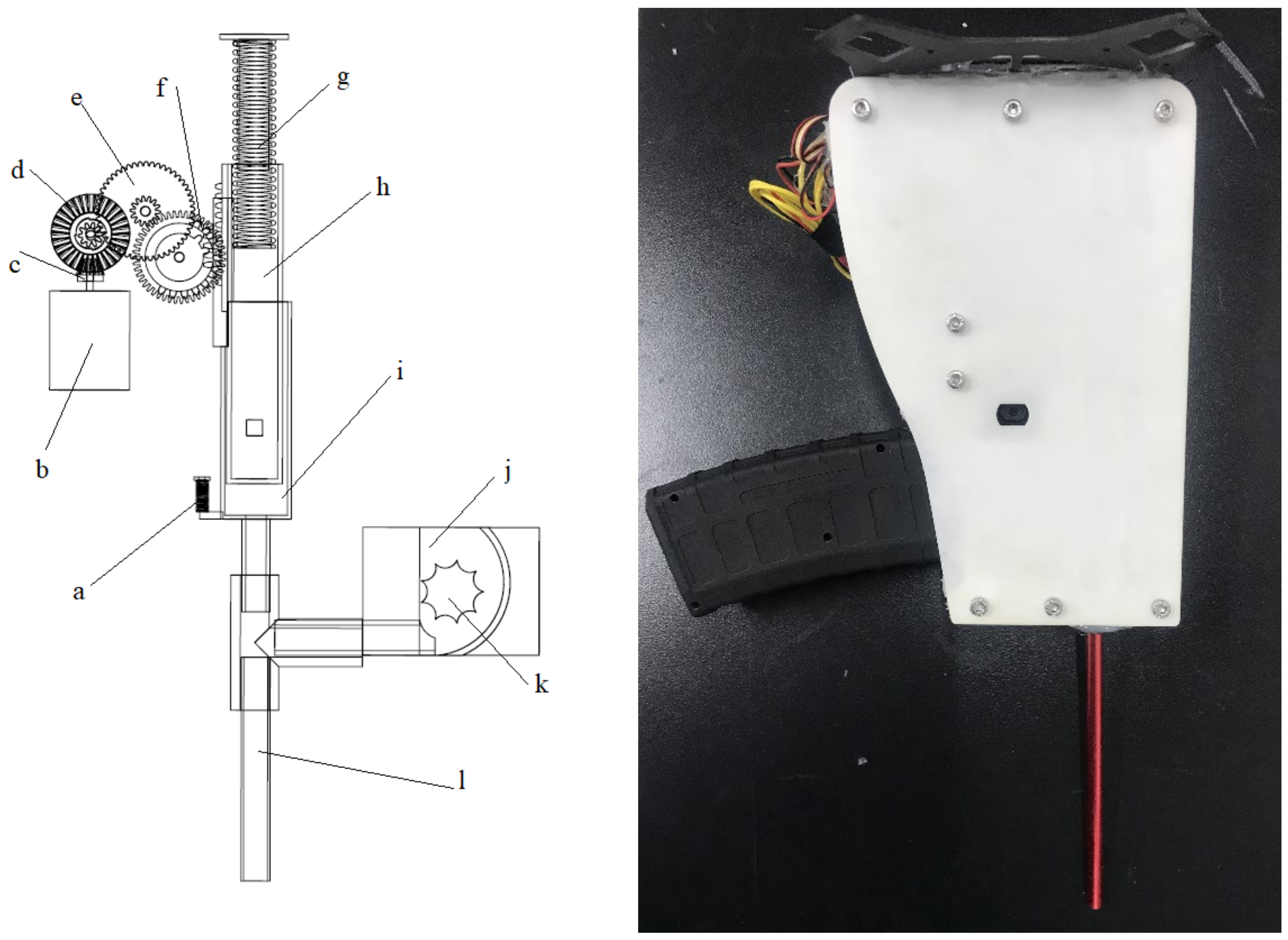
2.2. Development of the Seeding Device

The UAV seeding device is composed of an electronic control part and a mechanical device. The electronic control part controls the start, stop, and launch speed of the seed launching cylinder of the mechanical device, while the other part controls the sowing speed and seed sowing distance, coordinates the filling motor during the seed loading process, and executes the precise loading and sowing of seeds. The electronic control part is mainly composed of a microcontroller unit (MCU), a motor drive circuit, a motor speed control circuit, a seeding mode circuit and a communication circuit. The wireless communication device monitors the ground control command, and the remote control seeding device can be induced to sow by receiving the wireless control signal command. After receiving the sowing command, the MCU chip controls the motor drive circuit according to the sowing command and controls the rotation of the two motors in coordination with each other to complete the sowing operation.
The motor speed control circuit and delay algorithm are used to control the start and stop of the sowing motor and the sowing speed of the sowing machine. Different sowing modes combined with different flight modes can realize one point per plant, one point per many plants, and so on. Single-point sowing and continuous sowing can meet the demands of different seed types and different sowing conditions. Figure 2 shows the electrical component diagram of the seeding emitter control.
The mechanical part of the seed launcher is mainly composed of two motors, a plurality of gears, springs, cylinders, a launching tube, a seed storage bin, and so on. The motor provides sowing power and drives the gear to compress the cylinder spring. The spring potential pushes the cylinder, and the cylinder is filled with compressed gas. The seed is ejected by the compressed gas from the launch tube to complete the seeding. The mechanical design of the seed emitter is shown in Figure 3.
When sowing, the MCU chip controls the rotation of the accumulator motor. Under the action of the gear transmission, Gear I rotated Gear II, Gear III, and Gear IV in turn. Gear II and Gear III are reduction gears. Gear IV has three layers of gears, two of which are semi gears, which are connected with Cylinder I and Cylinder II, respectively. First, the rotation of Gear IV drives the gear Cylinder II and compresses Spring II. As Gear IV rotates the gap between Cylinder I and Cylinder II, Gear IV drives Cylinder I and compresses Spring I. Cylinder II moves a fixed distance, and the MCU controls the seed loading motor to transport the seeds into the launch tube entrance. Gear IV continues to rotate Cylinder II and Gear IV to separate, and Cylinder II bounces back to its original position under the force of Spring I, pushes the seeds into the launch tube, and seals the launch tube entrance. The MCU controls the loading motor to stop it from turning. Gear IV continues to rotate and separate Cylinder I from Gear IV, and Cylinder I rebounds rapidly under the action of Spring II. In Cylinders I and II, under the action of a spring, compressed air generates power to launch the seeds out of the launch tube.
In this paper, the seed emitter generates elastic potential energy after being powered by the motor, and the initial spring pressure F1 is given by Equation (1).
F1 = k × x1
where k is the spring coefficient and x1 is the amount of elongation (compression).
After the displacement of Cylinder II reaches the fixed position, the spring back pressure F2 is given by Equation (2).
F2 = k × x2
where k is the spring coefficient and x2 is the amount of elongation (compression).
The kinetic energy ES generated by the springs is given by Equation (3).
ES = F2 − F1 = 1/2 × k (x22 − x12)
The elastic force of the spring pushes the cylinder to convert elastic potential energy ES into the kinetic energy of compressed air to produce gas pressure. The gas pressure pushes the seeds out of the launch tube, and the seed emission kinetic energy E is given by Equation (4).
E = ES − ESL − EGL = 1/2 × k(x22 − x12) − ESL − EGL
ESL is the kinetic energy loss of the cylinder. EGL is the loss of kinetic energy.
Equation (4) shows that the greater the elastic coefficient of the seed launcher spring, the greater its kinetic energy. The smaller the energy loss during the kinetic energy conversion of the cylinder of the seed launcher, the faster the seed launching speed. Therefore, by increasing the elastic coefficient and changing the cylinder, the kinetic energy of seed emission can be increased, and the seed can be emitted with greater speed, allowing it to be sown deeper. The energy transfer diagram of the seed launcher is shown in Figure 4.

2.3. UAV Seeding Route Planning

In this study, a high-resolution image map was used for regional planning and rapid mapping of irregular plots. The image information was used to determine the surveying and mapping routes and set flight parameters, as well as determine the seeding area, analyze the characteristics of the seeding area, and complete the navigational planning. The planning of the UAV’s seeding route was based on the GNSS positioning system. The UAV routes were set according to preset parameters (sowing speed, seed spacing, single-hole sowing number, row spacing, and flight altitude). Route planning mainly determines the flight trajectory of the UAV according to the size of the seeding area and the spacing of the seeding rows. The UAV control points were set, accurate positioning information was determined according to GNSS RTK, and the take-off position was set. A key GNSS take-off position was set according to the scheduled route of the automatic flight and automatic return landing. The seeding route was interrupted when the battery voltage was low or the seed storage bin was empty. The planting will be continued automatically after replacing the battery and filling the seed bin. When the sowing area is small, cruise route planning is adopted.
In this paper, the multi-objective optimal route planning method for UAV afforestation is divided into three main processes: first, the optimal route of each single afforestation area is planned; then, the initial node of each afforestation area is obtained; finally, the optimal operation planning among multiple areas is obtained according to the shortest path algorithm. The multi-objective optimal route plan is shown in Figure 5.

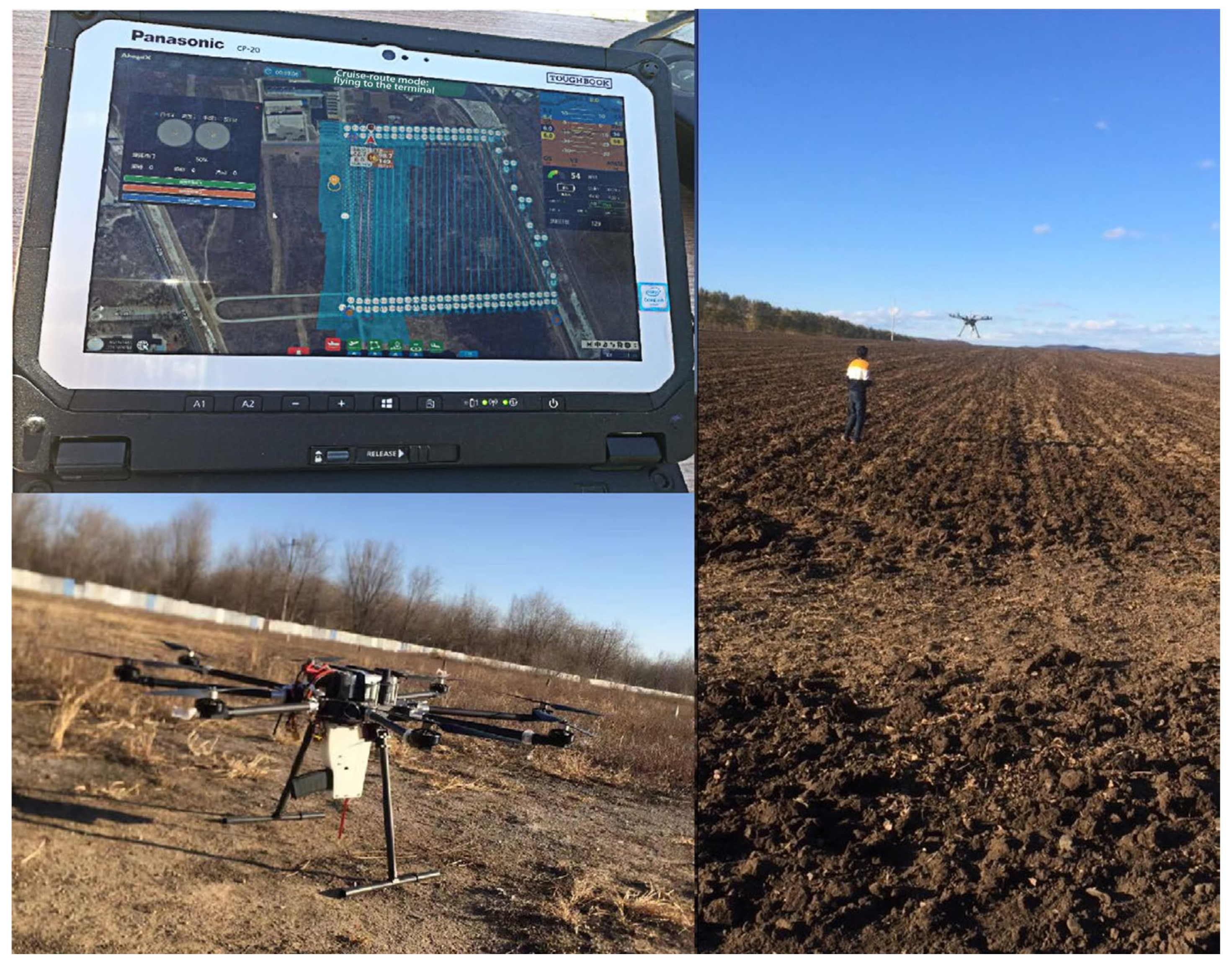
2.4. Description of the Test Area

The experimental region is located southeast of Hulunbuir, with east longitudes ranging from 124°10′ to 124°40′ and north latitudes ranging from 49°30′ to 49°60′. To its north is the Great Hinggan Mountain forest area, and to the south is the Songnen Plain, which belongs to the junction of plain and mountain areas. The altitude is between 300 and 450 m, and the area has a temperate continental climate with a montane microclimate. The annual average temperature is −0.8 °C, the annual average rainfall is 450 mm, and the average humidity is 85%. There are 2439.1 yearly sunshine hours, and the frost-free period is 110 days. Figure 6 shows an overview of the study area.

2.5. Experimental Test Gradient

We will test the seeding situation of this device in three gradients using the above-mentioned principle and mechanism. The test content consists of a sowing depth test, a seed measurement test, and an afforestation positioning accuracy test.
Sowing depth experiments were carried out in different soil types. The test sowing equipment was used to sow in soil types with a sediment content of less than 20% and between 20% and 50%. Soybean seeds were used in the experiment. The flight altitude of the afforestation UAV was set to 2 m, while the flight speed was 0.5 m/s. In the afforestation area, 100 seeds were selected by random sampling. The depth from the bottom of the seeds to the ground surface was measured as the sowing depth by using vernier calipers.
The UAV seeding device was tested at different seeding speeds when the flight altitude was 2 m, and the flight speed was 0.5 m/s. When the UAV was flying at a uniform speed, it seeded continuously, and the seedless area remained unsown. It was qualified that the test sowing depth was more than 1 cm, and a distance of 100 m from the sowing area was rand only selection criteria. Under different sowing speeds, the qualified index and missing index of the UAV sowing system were tested.
The afforestation precision test of the UAV seeding system was carried out with a seeding speed of 60 seeds per minute and a flight speed of 1 m/s. The UAV flew according to the designated route, and the seeds were placed either manually via Global Positioning System (GPS) or automatically via RTK on the designated route. After sowing, GNSS RTK was used to measure and record the positional information of each seed after sowing in three ways.

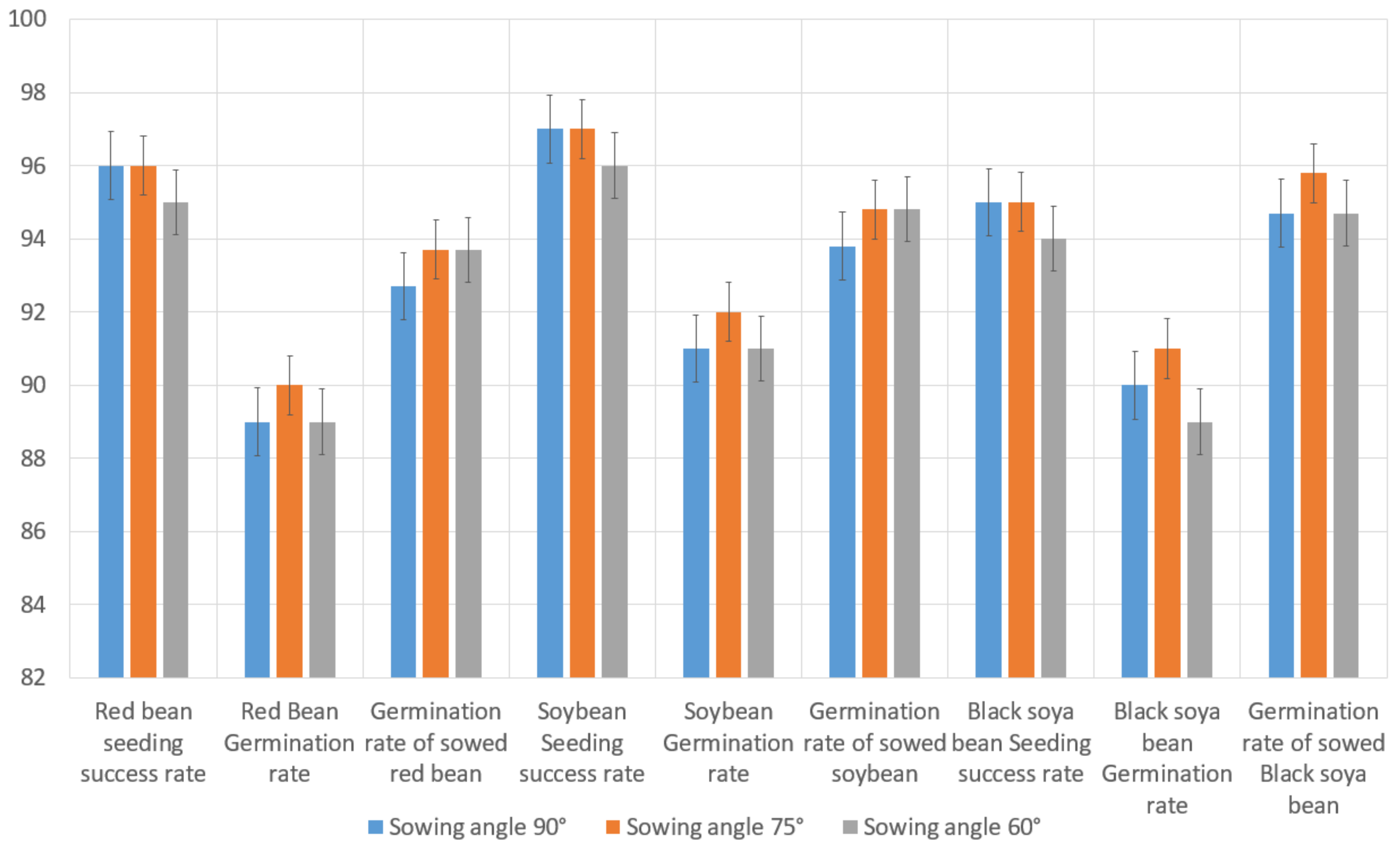
3. Field Experiment and Results

3.1. Sowing Depth Test

Figure 7a showed the experimental results obtained in soil with a sediment content of less than 20% and an average sowing depth of 3 cm. Figure 7b showed soil with a sediment content of 20–50%, in which the average sowing depth was 2.3 cm. Among the 100 seeds randomly selected, 96 seeds were at depths greater than 1 cm, corresponding to a success rate of 96%. There were six fewer in Figure 7b than in Figure 7a, and the sowing success rate was 90%. As could be seen in Figure 7, the sowing in soils with a sediment content of less than 20% was deeper, the sowing depth distribution was more uniform, and the sowing effect was better. By contrast, the sowing depth distribution in soils with sediment contents of 20–50 was more dispersed. The stability of the sowing depth of this equipment in the soil with 20–50% sediment content was poor, which was related to the content of sand and gravel in the soil. It was difficult to sow in soils with a high sand content because the impact of the seeds on the soil’s sand and stone resulted in a shallow sowing depth. Therefore, greater sowing intensity was needed in soils with high sand content.

3.2. Seed-Metering Test

As could be seen from Table 3, when the sowing speed was slower, the qualified index of sowing was higher, and the missed seeding index was lower. With the increase in sowing speed, the index of seeding omission increased, and the index of qualified sowing decreased accordingly. When the sowing speed reached 150 r/min, the missed seeding index began to increase, and the faster the sowing speed, the higher the missed seeding index.

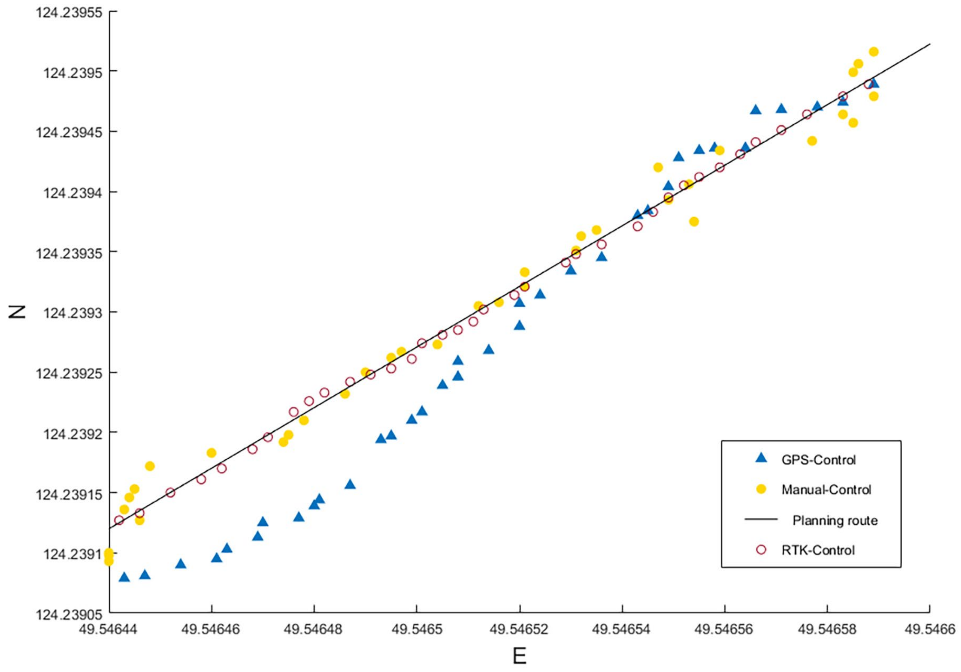
3.3. Afforestation Positioning Accuracy Test

According to the GNSS information, the relationship between the flight route and seeding position was plotted, as shown in Figure 8.
Figure 8 showed the seed distribution map for each seed route. Manual control of seeding was basically within the scope of the preset seeding route, but the distribution from seeding was not uniform, and the phenomenon of replaying and missing seeding was seen often on the seeding route. The seed distribution of the automatic control sowing was more uniform, with less missing sowing that needed rework. The error of the distance between the seed position and the preset seeding route was measured, and the error of the seeding route was obtained. The measurement results were shown in Figure 9.
The results showed that the average absolute error of manual control seeding was 47.2 cm. The average absolute error of GPS automatic seeding was 140.8 cm, and the error of RTK automatic seeding was 7.6 cm. As can be seen in Figure 9, when the automatic control seeding mode was used, there was a large distance error between the location of some sown seeds and the preset route. The reason for the large deviation between the seeding position and the preset seeding route was the dynamic GPS positioning signal deviation for the UAV. It could be concluded that a robust positioning system of the UAV was the key to improving seeding accuracy.
In this study, an afforestation UAV system was set to hover in a fixed position for the seeding test. GNSS RTK was used to measure coordinate information for five positions in the experiment. Five coordinates were loaded into the UAV afforestation system, and hovering seeding was carried out on these five positions, measuring the distance between the afforestation position and the preset position, respectively. The results were shown in Table 4.
It is visible from Table 4 that the error values of hovering positioning precision varied between 7.2 and 8.6 cm, and the average error was 7.7 cm. The variance showed that the error distribution was reasonable. Hovering position sowing had better afforestation precision.

4. Discussion

In recent years, with the continuous development of modern UAVs, the advancement of related technology, machinery, and data processing has prompted aerial seeding to become an inevitable trend in forestry development in the future [44,45,46,47]. UAVs have the characteristics of flexibility and portability, which can overcome the complex terrain and landform problems in hilly and mountainous areas that are difficult to reach with ground vehicles and machinery. The use of UAV afforestation technology can provide reliable technical support for afforestation.
In forestry production, seed sowing density is closely related to the yield of the products [48]. Good sowing density is one of the most important factors that need to be addressed to improve yields in forestry. The effects of different sowing densities on the coverage of pasture and hay grassland in planting, ecological restoration, or other vegetation restoration activities are significantly different [49,50,51,52]. The accuracy of unmanned aerial vehicle remote sensing decreases with the complexity of the plant structure [53]. The traditional ground air seeder has good seeding speed and stability [54] but cannot be used in inaccessible terrains.
According to the relationship between different seeding speeds and seed omission (Table 3), the seeding stability of the UAV seeding device was better at lower speeds. When the sowing speed is too fast, the leakage index increases obviously, which is related to the structural design of the mechanical equipment used in this study.
The mechanical equipment was filled with seeds, and single seeds were launched and sown. This sowing method has good stability, can ensure that each seed is emitted at a balanced speed during sowing, and can better regulate the row spacing of the sown plants. However, when the seeding speed is too fast, the cylinder moves too fast, and the seeds are not filled into the launching tube in time before the cylinder bounces back, leading to missed sowing sites. Therefore, when the shooting speed of the seeding cylinder is too fast, the missed seeding index will rise.
After verification, the qualified rate of sowing was more than 95% when the sowing speed of the sowing device was 90–120 r/min. With this sowing speed, the fastest coverage was 375 min/ha in a general 45 000 plants/ha corn planting area [55]. The sowing speed of maize reached 27 m/min in a field with a plant spacing of 30 cm [56]. The sowing efficiency can satisfy the needs of normal maize sowing operations. When the sowing speed of the sowing device in this study was 150 r/min per minute, a qualified rate of sowing above 90% could still be guaranteed, illustrating the device’s good performance. The start-stop and shoot speed control of the seeder are coordinated with the flight speed and flight mode of the UAV, which can precisely control seed spacing, increase seeding speed and quality, and have good adjustability. It can realize GNSS positioning for single-point single-plant seeding, single-point multi-plant seeding, and route continuous seeding. The precision afforestation system of the UAV can be applied to the precise seeding of many seeds.
Different seeds need different sowing depths [57,58], which directly determines the germination rate and is closely related to yield [7]. This paper fully considers that different sowing tasks require different sowing depths. In terms of research and design, for different seeding requirements, different elastic accumulator springs are used to increase the driving force and launching tubes of different lengths are selected to adjust the acceleration time of the seeds during launching. As shown in Table 5, the experimental results of seeding using manganese steel springs with different specifications and different launch tube lengths were compared.
As can be seen in Table 5, the larger the spring, the more powerful the seed ejection, and the deeper the maximum and the average depths of sowing. Based on the experimental results, it could be concluded that the length of the emitter tube also played an important role in the regulation of sowing depth. The longer launch tube provided a longer acceleration time for seeds, and the sowing depth would be deeper. The maximum sowing depth of seeds was 6.5 cm. Choosing and fitting launching tubes of different lengths could accurately and effectively adjust and control the seed launching speed. This, in turn, could precisely control the sowing depth of the seeds, ensure a suitable placement in the soil, and meet the needs of sowing a variety of agricultural and forestry crops.
Accurate seeding is a key technology and challenging problem in UAV afforestation systems. At present, many studies have been carried out to install spraying devices on UAVs for aerial seeding [37]. This UAV seed spraying technology is suitable for grass seed planting in ecological restoration, but it cannot be used to plant seeds in the soil. However, most seeds cannot germinate when simply scattered on top of the soil. The sowing device developed in this study can use the driving force of gas compression to launch seeds at high speed and sow them into the soil, which has a better sowing effect than the spraying method. It was found that there are still some problems with vertical seeding when the UAV is in the air. When seeds are emitted into the soil vertically, the soil cannot cover all the seeds completely. There are still some seeds with insufficient soil scattered on the surface, which will affect the germination. Therefore, we proposed a tilt launching sowing method. By adjusting the stabilizer of the seeding device, the angle between the launching direction of the seeding device and the ground is tilted.
Figure 10 showed there was not enough soil above the seeds in the vertical seeding path. The soil above the seed was loosened, and the loose soil on both sides of the path was scattered on the surface of the seed due to vibration. In this way, the soil cover above the seeds was unstable and uneven. Compared with vertical sowing, tilted sowing leaves more soil above the seeds after they were sown into the soil. With the vibration of the seeds when they entered the soil, the inclined path of the seeds would be loosened as the seeds entered the soil. It was easier to cover the whole seed and close the path of the seeds into the soil. Thus, tilted sowing had better soil cover, and still provided the required vertical depth of seed sowing.
The experiment of tilted seeding was carried out by adjusting the stabilizer of the seeding device. In this study, three sowing experiments were carried out with stabilizer pitch angles of 90°, 75°, and 60°, respectively. Soybean, black bean, and red bean were selected to sow 200 seeds each. The success rates of sowing, germination rates, and germination rates of sown seeds were tested. The comparative experiment results of the three modes of crop sowing were shown in Figure 10.
Among the three sowing modes with tilt angles of 90°, 75°, and 60°, the success rates of 90° and 75° sowing were higher, while the success rates of 60° sowing were slightly lower (Figure 10). The change in seed incidence angle affected the success rate of sowing. The smaller the angle between seed emission and the ground, the lower the success rate of sowing. The germination rate of three kinds of agricultural crops was best when the seeding emission angle was set to 75°. Thus, it could be concluded that the 75° tilt angle was more suitable for sowing. The difference in germination rate between 90° and 60° was not obvious. The main reason was that the success rate of 60° seeding was the lowest, and the failure of some seeds to enter the ground affected the germination rate. The germination rate of 75° sowing was the best among the successfully sown seeds, while that of 60° sowing was slightly higher than that of 90° sowing. The main reason was that the seed coverage with 75° sowing was better than with 90° sowing, and the depth of sowing was greater than with 60° sowing. The inclined sowing method could therefore effectively alleviate the problem that the upper surface of seeds sown on vertical ground could not be completely covered by soil and reduce the bareness of the upper surface of seeds. Based on the results, it was remarkable that the success rate of the sowing method with a 75° tilt was higher, the germination rate of the seeds was better, and it was more suitable for UAV sowing systems.
In the future, we will continue to explore ways to improve the sowing accuracy and better seed filling methods to improve the stability and accuracy of the UAV seeding device. The research will continue to develop lighter and more efficient cylinders to provide greater pneumatic power for seeding and improve the speed of seed launching. In future research, a high-pressure gas tank will be used in the seeding device of large and medium-sized afforestation UAVs. A high-pressure gas tank can provide 30 MPa of gas pressure, which can provide better seeding power and deeper seeding depth for large seeds. However, the high-pressure gas tank has a large self-weight, so it is not suitable for small UAV seeding systems like the one used in this study.

5. Conclusions

In this study, a precision afforestation system was developed using UAV technology, mechanical technology, computer technology, and electronic information technology. The application of modern UAV technology in forestry sowing has solved several key issues of UAV precision afforestation, such as precise control of sowing depth, precise positioning of afforestation, precise quantitative sowing, and so on. The main results are as follows:
  • The UAV seeding equipment studied in this paper can stably and effectively sow seeds into the soil. The stability of a given sowing depth is related to the content of sand and gravel in the soil. It is difficult to sow in sandy loam soil with a high sand content. Accordingly, the sowing qualification index of the soil with a small sand content was higher, and the sowing depth was greater;
  • The UAV seeding equipment had good stability, a low missed seeding index, and a well qualified index;
  • For some seeds, the precision of seed position sown by the UAV can meet the practical requirements of sowing operations;
  • The precision afforestation system of the UAV can accurately and effectively adjust and control the speed of seed launching. The system enables precise control of the sowing depth to ensure a suitable seed position for a variety of agricultural and forestry crops.

Author Contributions

Conceptualization, H.L., Z.C., and Z.W.; Methodology, H.L. and Z.C.; Software, H.L.; Validation, H.L. and J.L.; Formal analysis, H.L. and Z.C.; Investigation, H.L., Z.C., and J.L.; Resources, H.L. and Z.W.; Data curation, Z.C. and J.L.; Writing—original draft, H.L. and Z.C.; Writing—review and editing, H.L.; Visualization, Z.C. and J.L.; Supervision, Z.W.; Project administration, H.L. and Z.W.; Funding acquisition, H.L. and Z.W. All authors have read and agreed to the published version of the manuscript.

Funding

This research was funded by the National Key R&D Program of the 14th Five-Year Plan (China) (2022YFC3105100), the National Key R&D Plan of the 13th Five-Year Plan (China) (2017YFC1405300) and the Young Science Fund of the National Natural Science Foundation of China (42007420).

Institutional Review Board Statement

Not applicable.

Informed Consent Statement

Not applicable.

Data Availability Statement

Data is available upon request.

Acknowledgments

The authors thank all anonymous reviewers and journal editorial staff for their efforts in improving the quality of this manuscript.

Conflicts of Interest

The authors declare no conflict of interest.

References

  1. Schäfer-Landefeld, L.A.; Brandhuber, R.; Fenner, S.; Koch, H.J.; Stockfisch, N. Effects of agricultural machinery with high axle load on soil properties of normally managed fields. Soil Tillage Res. 2004, 75, 75–86. [Google Scholar] [CrossRef]
  2. Flower, K.C.; Crabtree, W.L. Soil ph change after surface application of lime related to the levels of soil disturbance caused by no-tillage seeding machinery. Field Crops Res. 2011, 121, 75–87. [Google Scholar] [CrossRef]
  3. Townsend, J.S.; Chinsuwan, W.; Bethge, J.M.; Stobbe, E.H. Zero-tillage seeding machinery development at the university of manitoba. Soil Tillage Res. 1986, 8, 374. [Google Scholar] [CrossRef]
  4. Bochtis, D.D.; Sørensen, C.G.C.; Busato, P. Advances in agricultural machinery management: A review. Biosyst. Eng. 2014, 126, 69–81. [Google Scholar] [CrossRef]
  5. Augello, A.; Gaglio, S.; Lo Re, G.; Peri, D. Time-Constrained Node Visit Planning for Collaborative UAV–WSN Distributed Applications. Sensors 2022, 22, 5298. [Google Scholar] [CrossRef]
  6. Ren, H.; Zhao, Y.; Xiao, W.; Hu, Z. A review of UAV monitoring in mining areas: Current status and future perspectives. Int. J. Coal Sci. Technol. 2019, 6, 320–333. [Google Scholar] [CrossRef] [Green Version]
  7. Hadjichristodoulou, A.; Della, A.; Photiades, J. Effect of sowing depth on plant establishment, tillering capacity and other agronomic characters of cereals. J. Agric. Sci. 1977, 89, 161–167. [Google Scholar] [CrossRef]
  8. Dandois, J.P.; Olano, M.; Ellis, E.C. Optimal altitude, overlap, and weather conditions for computer vision uav estimates of forest structure. Remote Sens. 2015, 7, 13895–13920. [Google Scholar] [CrossRef] [Green Version]
  9. Chianucci, F.; Disperati, L.; Guzzi, D.; Bianchini, D.; Nardino, V.; Lastri, C.; Rindinella, A.; Corona, P. Estimation of canopy attributes in beech forests using true colour digital images from a small fixed-wing UAV. Int. J. Appl. Earth Obs. Geoinf. 2016, 47, 60–68. [Google Scholar] [CrossRef] [Green Version]
  10. Dainelli, R.; Toscano, P.; Di Gennaro, S.F.; Matese, A. Recent Advances in Unmanned Aerial Vehicle Forest Remote Sensing—A Systematic Review. Part I: A General Framework. Forests 2021, 12, 327. [Google Scholar] [CrossRef]
  11. Dainelli, R.; Toscano, P.; Di Gennaro, S.F.; Matese, A. Recent Advances in Unmanned Aerial Vehicles Forest Remote Sensing—A Systematic Review. Part II: Research Applications. Forests 2021, 12, 397. [Google Scholar] [CrossRef]
  12. Peña-Barragán, J.M.; López-Granados, F.; Jurado-Expósito, M.; García-Torres, L. Sunflower yield related to multi-temporal aerial photography, land elevation and weed infestation. Precis. Agric. 2010, 11, 568–585. [Google Scholar] [CrossRef] [Green Version]
  13. Vauhkonen, J.; Holopainen, M.; Kankare, V.; Vastaranta, M.; Viitala, R. Geometrically explicit description of forest canopy based on 3d triangulations of airborne laser scanning data. Remote Sens. Environ. 2016, 173, 248–257. [Google Scholar] [CrossRef]
  14. Chen, S.; McDermid, G.J.; Castilla, G.; Linke, J. Measuring Vegetation Height in Linear Disturbances in the Boreal Forest with UAV Photogrammetry. Remote Sens. 2017, 9, 1257. [Google Scholar] [CrossRef] [Green Version]
  15. Hyyppä, E.; Hyyppä, J.; Hakala, T.; Kukko, A.; Wulder, M.A.; White, J.C.; Pyörälä, J.; Yu, X.; Wang, Y.; Virtanen, J.P.; et al. Under-canopy UAV laser scanning for accurate forest field measurements. ISPRS J. Photogramm. Remote Sens. 2020, 164, 41–60. [Google Scholar] [CrossRef]
  16. Vanegas, F.; Bratanov, D.; Powell, K.; Weiss, J.; Gonzalez, F. A novel methodology for improving plant pest surveillance in vineyards and crops using uav-based hyperspectral and spatial data. Sensors 2018, 18, 260. [Google Scholar] [CrossRef] [Green Version]
  17. Szalay, K.D.; Deákvári, J.; Csorba, Á.; Milics, G.; Fenyvesi, L. Remote sensing applications to improve evaluation methods of various plant and soil parameters and efficiency of pest control. J. Phys. Chem. B 2013, 114, 13861–13865. [Google Scholar]
  18. Cardil, A.; Otsu, K.; Pla, M.; Silva, C.A.; Brotons, L. Quantifying pine processionary moth defoliation in a pine-oak mixed forest using unmanned aerial systems and multispectral imagery. PLoS ONE 2019, 14, 1–19. [Google Scholar] [CrossRef] [Green Version]
  19. Näsi, R.; Honkavaara, E.; Blomqvist, M.; Lyytikäinen-Saarenmaa, P.; Hakala, T.; Viljanen, N.; Kantola, T.; Holopainen, M. Remote sensing of bark beetle damage in urban forests at individual tree level using a novel hyperspectral camera from UAV and aircraft. Urban For. Urban Green. 2018, 30, 72–83. [Google Scholar] [CrossRef]
  20. Klouček, T.; Komárek, J.; Surový, P.; Hrach, K.; Janata, P.; Vašíček, B. The Use of UAV Mounted Sensors for Precise Detection of Bark Beetle Infestation. Remote Sens. 2019, 11, 1561. [Google Scholar] [CrossRef] [Green Version]
  21. Safonova, A.; Tabik, S.; Alcaraz-Segura, D.; Rubtsov, A.; Maglinets, Y.; Herrera, F. Detection of Fir Trees (Abies sibirica) Damaged by the Bark Beetle in Unmanned Aerial Vehicle Images with Deep Learning. Remote Sens. 2019, 11, 643. [Google Scholar] [CrossRef]
  22. Patel, N.R.; Bhattacharjee, B.; Mohammed, A.J.; Tanupriya, B.; Saha, S.K. Remote sensing of regional yield assessment of wheat in haryana, india. Int. J. Remote Sens. 2006, 27, 4071–4090. [Google Scholar] [CrossRef]
  23. Chen, H.; Liang, Z.; Liu, Y.; Liang, Q.; Xie, S. Integrated remote sensing imagery and two-dimensional hydraulic modeling approach for impact evaluation of flood on crop yields. J. Hydrol. 2017, 553, 262–275. [Google Scholar] [CrossRef] [Green Version]
  24. Faiçal, B.S.; Pessin, G.; Filho, G.P.R.; Carvalho, A.C.P.L.F.; Gomes, P.H.; Ueyama, J. Fine-tuning of uav control rules for spraying pesticides on crop fields: An approach for dynamic environments. Int. J. Artif. Intell. Tools 2016, 25, 1660003. [Google Scholar] [CrossRef] [Green Version]
  25. Castaldi, F.; Pelosi, F.; Pascucci, S.; Casa, R. Assessing the potential of images from unmanned aerial vehicles (uav) to support herbicide patch spraying in maize. Precis. Agric. 2017, 18, 76–94. [Google Scholar] [CrossRef]
  26. Williams, J.; Jackson, T.D.; Schönlieb, C.-B.; Swinfield, T.; Irawan, B.; Achmad, E.; Zudhi, M.; Habibi, H.; Gemita, E.; Coomes, D.A. Monitoring early-successional trees for tropical forest restoration using low-cost UAV-based species classification. Front. For. Glob. Chang. 2022, 5, 876448. [Google Scholar] [CrossRef]
  27. Moura, M.M.; de Oliveira, L.E.S.; Sanquetta, C.R.; Bastos, A.; Mohan, M.; Corte, A.P.D. Towards Amazon Forest Restoration: Automatic Detection of Species from UAV Imagery. Remote Sens. 2021, 13, 2627. [Google Scholar] [CrossRef]
  28. Gobbi, B.; Van Rompaey, A.; Loto, D.; Gasparri, I.; Vanacker, V. Comparing Forest Structural Attributes Derived from UAV-Based Point Clouds with Conventional Forest Inventories in the Dry Chaco. Remote Sens. 2020, 12, 4005. [Google Scholar] [CrossRef]
  29. Cao, L.; Liu, H.; Fu, X.; Zhang, Z.; Shen, X.; Ruan, H. Comparison of UAV LiDAR and Digital Aerial Photogrammetry Point Clouds for Estimating Forest Structural Attributes in Subtropical Planted Forests. Forests 2019, 10, 145. [Google Scholar] [CrossRef] [Green Version]
  30. Surový, P.; Ribeiro, N.A.; Panagiotidis, D. Estimation of positions and heights from UAV-sensed imagery in tree plantations in agrosilvopastoral systems. Int. J. Remote Sens. 2018, 39, 4786–4800. [Google Scholar] [CrossRef]
  31. Panagiotidis, I.; Abdollahnejad, A.; Slavík, M. 3D point cloud fusion from UAV and TLS to assess temperate managed forest structures. Int. J. Appl. Earth Obs. Geoinf. 2022, 112, 102917. [Google Scholar] [CrossRef]
  32. Mohan, M.; Richardson, G.; Gopan, G.; Aghai, M.M.; Bajaj, S.; Galgamuwa, G.A.P.; Vastaranta, M.; Arachchige, P.S.P.; Amorós, L.; Corte, A.P.D.; et al. UAV-Supported Forest Regeneration: Current Trends, Challenges and Implications. Remote Sens. 2021, 13, 2596. [Google Scholar] [CrossRef]
  33. De Rango, F.; Palmieri, N.; Santamaria, A.F.; Potrino, G. A simulator for UAVs management in agriculture domain. Simul. Ser. 2017, 49, 149–156. [Google Scholar]
  34. Surovỳ, P.; Kuželka, K. Acquisition of forest attributes for decision support at the forest enterprise level using remote-sensing techniques—A review. Forests 2019, 10, 273. [Google Scholar] [CrossRef] [Green Version]
  35. Lysych, M.; Bukhtoyarov, L.; Druchinin, D. Design and Research Sowing Devices for Aerial Sowing of Forest Seeds with UAVs. Inventions 2021, 6, 83. [Google Scholar] [CrossRef]
  36. Castro, J.; Morales-Rueda, F.; Navarro, F.B.; Löf, M.; Vacchiano, G.; Alcaraz-Segura, D. Precision restoration: A necessary approach to foster forest recovery in the 21st century. Restor. Ecol. 2021, 29, e13421. [Google Scholar] [CrossRef]
  37. Greipsson, S. Large-scale reclamation of barren lands in ice land by aerial seeding. Land Degrad. Dev. 2015, 10, 185–193. [Google Scholar] [CrossRef]
  38. Cancan, S.; Zhiyan, Z.; Rui, J.; Xiwen, L.; Xingang, H.; Rui, M.; Engineering, C.O. Design and parameter optimization of pneumatic rice sowing device for unmanned aerial vehicle. Trans. Chin. Soc. Agric. Eng. 2018, 34, 80–88. [Google Scholar]
  39. Wang, H.; Yu, S.; Liao, J.; Qing, X.; Sun, D.; Ji, F.; Song, W.; Wang, L.; Li, T. A Robot Platform for Highly Efficient Pollutant Purification. Front. Bioeng. Biotechnol. 2022, 10, 903219. [Google Scholar]
  40. Precision Forestry. Available online: https://www.droneseed.co/ (accessed on 12 December 2018).
  41. BioCarbon Engineering. Available online: https://www.biocarbonengineering.com/ (accessed on 12 December 2018).
  42. Castro, J.; Morales-Rueda, F.; Alcaraz-Segura, D.; Tabik, S. Forest restoration is more than firing seeds from a drone. Restor. Ecol. 2022, 31, e13736. [Google Scholar] [CrossRef]
  43. Rice, C.R.; McDonald, S.T.; Shi, Y.; Gan, H.; Lee, W.S.; Chen, Y.; Wang, Z. Perception, Path Planning, and Flight Control for a Drone-Enabled Autonomous Pollination System. Robotics 2022, 11, 144. [Google Scholar] [CrossRef]
  44. Novikov, A.I.; Ersson, B.T. Aerial seeding of forests in Russia: A selected literature analysis. IOP Conf. Ser. Earth Environ. Sci. 2018, 226, 012051. [Google Scholar] [CrossRef]
  45. Andrio, A. Development of UAV technology in seed dropping for aerial revegetation practices in Indonesia. IOP Conf. Ser. Earth Environ. Sci. 2019, 308, 012051. [Google Scholar] [CrossRef] [Green Version]
  46. Vovchenko, N.; Novikov, A.; Sokolov, S.; Tishchenko, E. A proposed technology to ensure high-precision aerial seeding of certified seeds. IOP Conf. Ser. Earth Environ. Sci. 2020, 595, 012066. [Google Scholar] [CrossRef]
  47. Olenin, O.A.; Zudilin, S.N.; Tsarkov, A.V. Development of a Russian pendant seeder-spreader for a multicopter in the conditions of import substitution. IOP Conf. Ser. Earth Environ. Sci. 2021, 954, 012054. [Google Scholar] [CrossRef]
  48. Marín, C.; Weiner, J. Effects of density and sowing pattern on weed suppression and grain yield in three varieties of maize under high weed pressure. Weed Res. 2015, 54, 467–474. [Google Scholar] [CrossRef]
  49. Burton, C.M.; Burton, P.J.; Hebda, R.; Turner, N.J. Determining the optimal sowing density for a mixture of native plants used to revegetate degraded ecosystems. Restor. Ecol. 2010, 14, 379–390. [Google Scholar] [CrossRef]
  50. Kirby, E.J.M. The effect of sowing date and plant density on barley. Ann. Appl. Biol. 2010, 63, 513–521. [Google Scholar] [CrossRef]
  51. Hecht, V.L.; Temperton, V.M.; Nagel, K.A.; Rascher, U.; Postma, J.A. Sowing density: A neglected factor fundamentally affecting root distribution and biomass allocation of field grown spring barley (Hordeum Vulgare L.). Front. Plant Sci. 2016, 7, 944. [Google Scholar] [CrossRef] [Green Version]
  52. Ren, Y.; Liu, J.; Wang, Z.; Zhang, S. Planting density and sowing proportions of maize–soybean intercrops affected competitive interactions and water-use efficiencies on the loess plateau, China. Eur. J. Agron. 2016, 72, 70–79. [Google Scholar] [CrossRef]
  53. Ma, Q.; Han, W.; Huang, S.; Dong, S.; Li, G.; Chen, H. Distinguishing Planting Structures of Different Complexity from UAV Multispectral Images. Sensors 2021, 21, 1994. [Google Scholar] [CrossRef]
  54. Yatskul, A.; Lemiere, J.P. Establishing the conveying parameters required for the air-seeders. Biosyst. Eng. 2018, 166, 1–12. [Google Scholar] [CrossRef]
  55. Shafi, M.; Bakht, J.; Ali, S.; Khan, H.; Khan, M.A.; Sharif, M. Effect of planting density on phenology, growth and yield of maize (Zea Mays L.). Pak. J. Bot. 2012, 44, 691–696. [Google Scholar]
  56. Adipala, E.; Takan, J.P.; Ogenga-Latigo, M.W. Effect of planting density of maize on the progress and spread of northern leaf blight from exserohilum turcicum infested residue source. Eur. J. Plant Pathol. 1995, 101, 25–33. [Google Scholar] [CrossRef]
  57. Brown, P.R.; Singleton, G.R.; Tann, C.R.; Mock, I. Increasing sowing depth to reduce mouse damage to winter crops. Crop Prot. 2003, 22, 653–660. [Google Scholar] [CrossRef]
  58. Photiades, I.; Hadjichristodoulou, A. Sowing date, sowing depth, seed rate and row spacing of wheat and barley under dryland conditions. Field Crops Res. 1984, 9, 151–162. [Google Scholar] [CrossRef]
Figure 1. Components of the UAV seeding system.
Sustainability 15 02212 g001
Figure 2. Electronic components of the seeding emitter control.
Sustainability 15 02212 g002
Figure 3. Design of the seed launcher. a. Spring I; b. Accumulator motor; c. Gear I; d. Gear II; e. Gear III; f. Gear IV; g. Spring II; h. Cylinder I; i. Cylinder II; j. Seed storage bin; k. Seed loading motor; l. Launch tube.
Sustainability 15 02212 g003
Figure 4. Energy transfer diagram of the seed launcher. a. The electric motor provides power and generates elastic potential energy. b. The elastic force of the spring pushes the cylinder, converting the elastic potential energy into the kinetic energy of compressed air, resulting in gas pressure. c. The gas pressure pushes the seeds out of the launch tube, and the seeds launch kinetic energy.
Sustainability 15 02212 g004
Figure 5. Multi-objective optimal route. The horizontal axis and vertical axis of the coordinate system are distance in meters. The black line is the range of sowing plots, the green line is the sowing route in each plot, and the dark blue line is the flight route from the end of the plot to the beginning of the next plot.
Sustainability 15 02212 g005
Figure 6. Survey of the research area.
Sustainability 15 02212 g006
Figure 7. Experimental results of sowing depth. (a) Soil with a sediment content of less than 20%; (b) Soil with a sediment content of 20–50%.
Sustainability 15 02212 g007
Figure 8. Location of seed sowing.
Sustainability 15 02212 g008
Figure 9. Error of the distance within the sowing route.
Sustainability 15 02212 g009
Figure 10. Results of sowing three different crops by ejecting the seeds at different angles. The longitudinal axis unit is %.
Sustainability 15 02212 g010
Table 1. The hardware configuration of UAV seeding system.
UAV Seeding System ContentHardware ConfigurationRemarks
Support and Appearance8-rotor S1000 UAV frame produced by DJI Company (China)Symmetrical motor wheelbase 1045 mm
Dynamic SystemHigh-speed Electro-Tuning
4114pro Motor
Electricity: 40A
Number: 8
Flight Control SystemXAG SUPERX2 RTK
Seeding DeviceOne Microcontroller Unit and four circuits
Two motors, two cylinders, a launching tube, a seed storage bin
Electronic control part
Mechanical device
SensorRanging RadarThe maximum range: 30 m.
Video Surveillance Systemhigh-definition camera
DJI Lightbridge image transmission
Pixel: 16 megapixels
HD: 2.4 G
Table 2. UAV parameters and flight parameters.
UAV ParametersFlight Parameters
Single arm length386 mmTake-off weight6.0~11.0 kg
Center frame diameter337 mmBattery power16,000 mAh
Center frame weight1520 gMaximum power4000 W
Landing gear size660 mm L × 511 mm W × 305 mm HHovering power1500 W (take-off weight 9.5 kg)
Motor KV value400 rpm/VHover time 15 min15 min (take-off weight 9.5 kg)
Working voltage6S LiPo (22.2 V)Working environment−10~+40 °C
mm is millimeter; g is gram; rpm/V is revolutions per minute/volt; kg is kilogram; mAh is milliampere hour; W is watt.
Table 3. Results of missed sowing at different seeding speeds.
NumberSeeding Speed r/minMissed Seeding Index/%Conformity Index/%
1301.097.0
2302.096.0
3301.097.0
4601.597.5
5602.096.5
6601.098.0
7902.796.5
8902.796.0
9903.096.0
10120–1253.595.7
11120–1252.896.5
12120–1253.595.5
13150–1556.292.4
14150–1555.293.2
15150–1555.493.6
16180–1859.389.3
17180–1859.688.2
18180–18510.387.3
19240–25015.183.8
20240–25016.781.1
21240–25016.981.2
22270–30025.673.3
23270–30019.578.3
24270–30026.172.7
mm is minute; % is percentage.
Table 4. Location hovering seeding results of UAV.
NumberEast Longitude/°North Latitude/°Average Error/cmVariance/cm2
1124.23980349.5466977.21.75
2124.23991749.5467447.74.12
3124.24004149.5467908.32.76
4124.24016449.5468368.61.46
5124.24030049.5468816.73.07
Average 7.73.23
° is degree; cm is centimeter; cm2 is square centimeter.
Table 5. Sowing depths obtained using different springs and launch tubes.
NumberSpring Type/mmLaunch Tube Length/mmMaximum Depth/cmAverage Depth/cm
11.2 × 15 × 1502503.52.1
21.6 × 15 × 1502504.43.1
32.0 × 15 × 1502506.54.1
41.6 × 15 × 1501503.82.5
51.6 × 15 × 1503505.13.4
mm is millimeter; cm is centimeter.
Disclaimer/Publisher’s Note: The statements, opinions and data contained in all publications are solely those of the individual author(s) and contributor(s) and not of MDPI and/or the editor(s). MDPI and/or the editor(s) disclaim responsibility for any injury to people or property resulting from any ideas, methods, instructions or products referred to in the content.

