
Advancement of Remote Sensing for Soil Measurements and Applications: A Comprehensive Review

 ,
,  ,
, 
Abstract
:1. Introduction
- Highlighting the different detection methods, types, parts, and applications of RS techniques in soil measurements;
- Analyzing the advantages and disadvantages of the measurements of soil properties;
- Elucidating the advancements in data processing techniques and approaches used to analyze remote sensing data for soil measurement applications;
- Exploring the potential of RS for precision agriculture and site-specific soil management. Monitoring soil variability at high resolution and in real-time allows for targeted interventions, optimized resource allocation, adequate yields, enhanced environmental sustainability, and minimized inputs;
- Providing a deep understanding of the advancements in RS for soil measurement application;
- Synthesizing the latest research, methodologies, and applications to adequately update harnessing the power of RS for soil resource management, environmental monitoring, and agricultural sustainability.
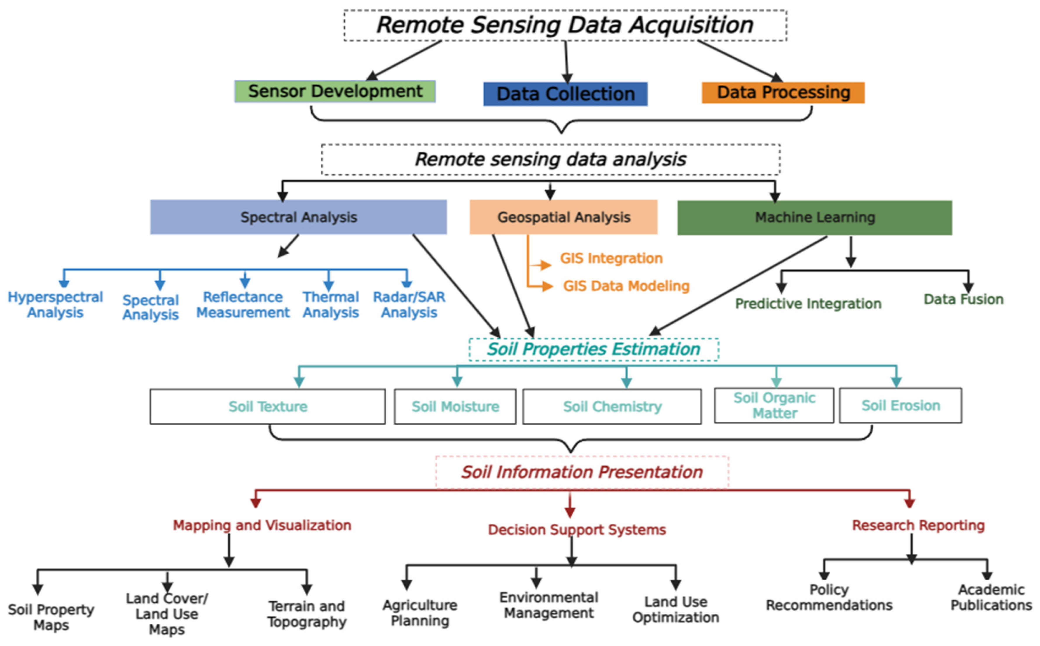
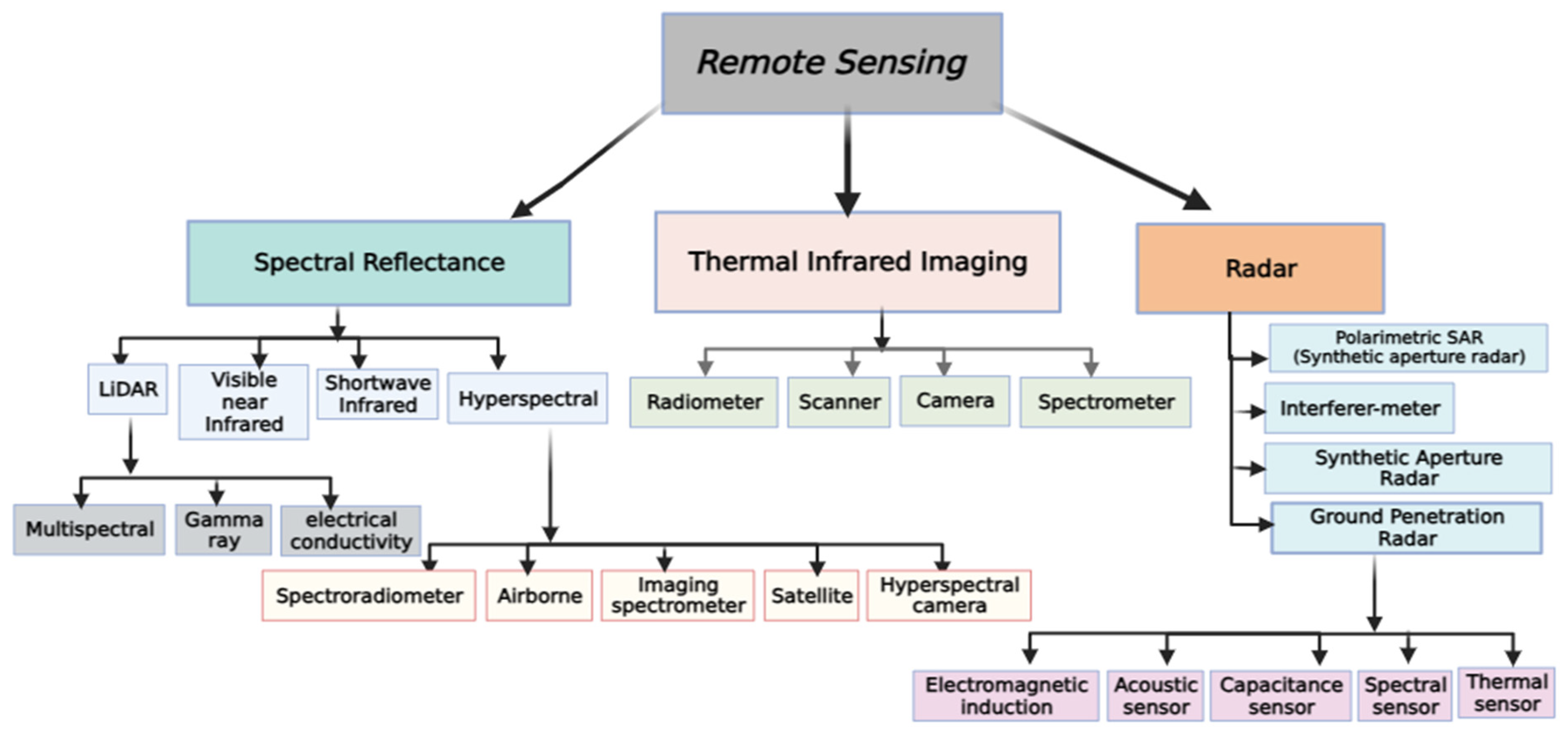
2. Remote Sensing Methods for Soil Measurements
2.1. Remote Sensing Methods in Soil Measurements
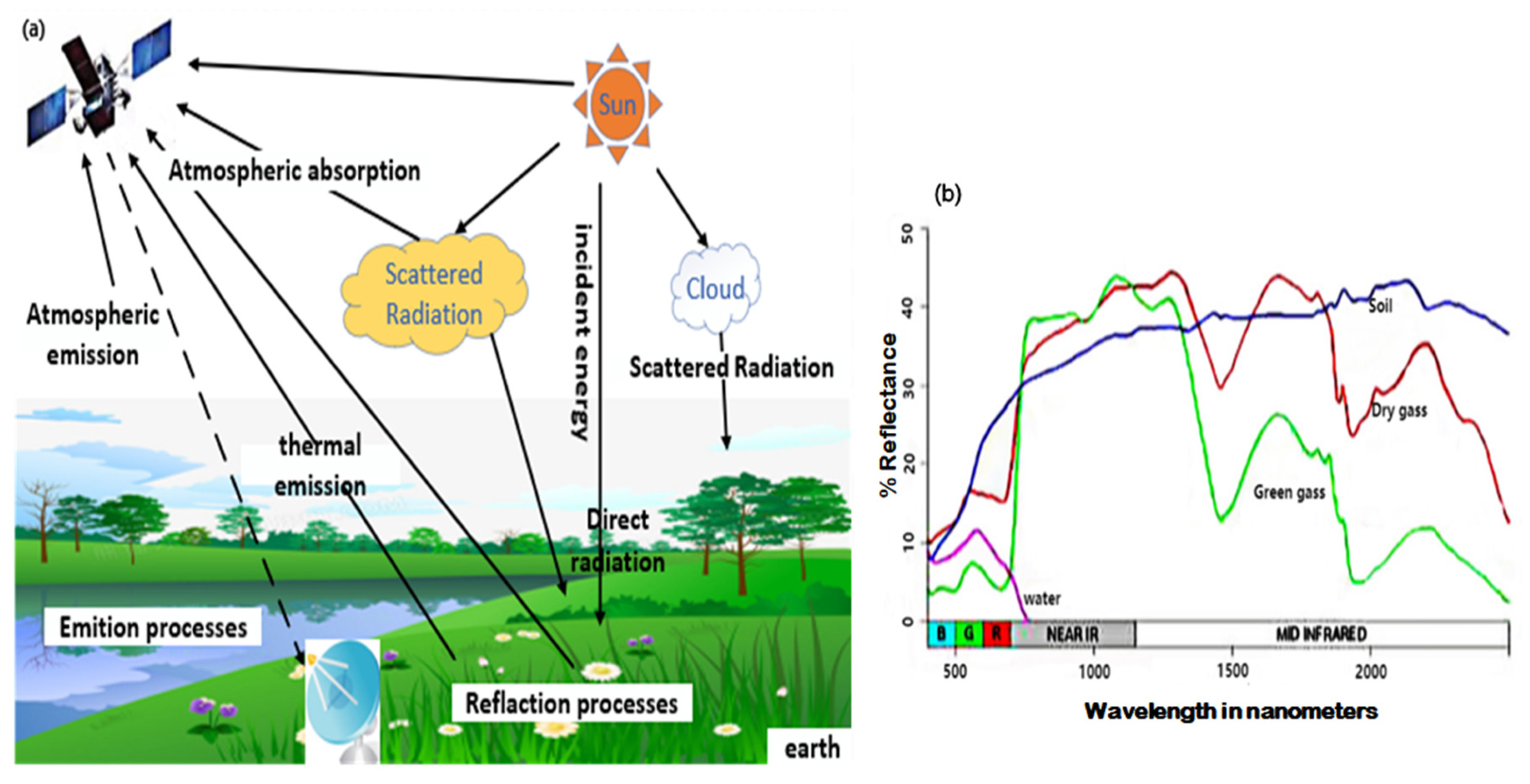
2.1.1. Spectral Reflectance Analysis
2.1.2. Thermal Infrared Imaging
2.1.3. Radar Remote Sensing
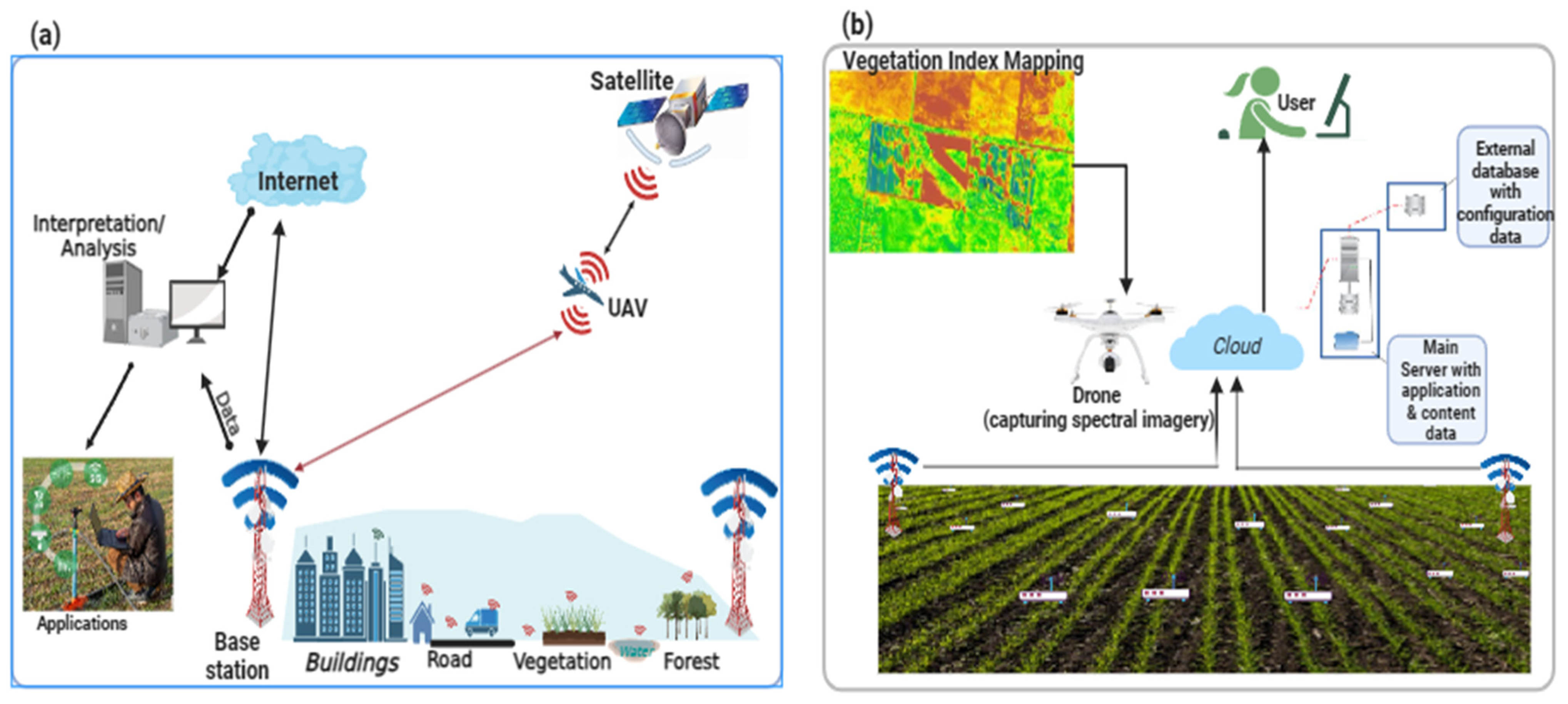
2.2. Remote Sensing Parts in Soil Measurements
2.3. Remote Sensing Application in Soil Measurements
2.4. Remote Sensing Techniques in Soil Measurements
3. Data Sources and Platforms Used in Soil Measurements
Satellite-Based Platform as Data Sources in Soil Measurements
4. Advances and Case Studies of Remote Sensing Technologies Applications in Soil Measurements
5. Discussion
Advancement to Decrease Uncertainties in RS Applications for Soil Measurement
6. Future Directions and Research Opportunities
7. Conclusions
Author Contributions
Funding
Institutional Review Board Statement
Informed Content Statement
Data Availability Statement
Conflicts of Interest
References
- Lal, R.; Mohtar, R.H.; Assi, A.T.; Ray, R.; Baybil, H.; Jahn, M. Soil as a Basic Nexus Tool: Soils at the Center of the Food–Energy–Water Nexus. Curr. Sustain./Renew. Energy Rep. 2017, 4, 117–129. [Google Scholar] [CrossRef]
- Chen, X.D.; Dunfield, K.E.; Fraser, T.D.; Wakelin, S.A.; Richardson, A.E.; Condron, L.M. Soil biodiversity and biogeochemical function in managed ecosystems. Soil Res. 2020, 58, 1–20. [Google Scholar] [CrossRef]
- Lal, R.; Bouma, J.; Brevik, E.; Dawson, L.; Field, D.J.; Glaser, B.; Hatano, R.; Hartemink, A.E.; Kosaki, T.; Lascelles, B.; et al. Soils and sustainable development goals of the United Nations: An International Union of Soil Sciences perspective. Geoderma Reg. 2021, 25, e00398. [Google Scholar] [CrossRef]
- Motia, S.; Reddy, S.R.N. Exploration of Machine Learning Methods for Prediction and Assessment of Soil Properties for Agricultural Soil Management: A Quantitative Evaluation; IOP Publishing: Bristol, UK, 2021. [Google Scholar]
- van Wesemael, B.; Chabrillat, S.; Sanz Dias, A.; Berger, M.; Szantoi, Z. Remote Sensing for Soil Organic Carbon Mapping and Monitoring. Remote Sens. 2023, 15, 3464. [Google Scholar]
- Lausch, A.; Baade, J.; Bannehr, L.; Borg, E.; Bumberger, J.; Chabrilliat, S.; Dietrich, P.; Gerighausen, H.; Glässer, C.; Hacker, J.M.; et al. Linking Remote Sensing and Geodiversity and Their Traits Relevant to Biodiversity—Part I: Soil Characteristics. Remote Sens. 2019, 11, 2356. [Google Scholar]
- Datta, D.; Paul, M.; Murshed, M.; Teng, S.W.; Schmidtke, L. Soil Moisture, Organic Carbon, and Nitrogen Content Prediction with Hyperspectral Data Using Regression Models. Sensors 2022, 22, 7998. [Google Scholar] [CrossRef]
- Sahbeni, G.; Ngabire, M.; Musyimi, P.K.; Székely, B. Challenges and Opportunities in Remote Sensing for Soil Salinization Mapping and Monitoring: A Review. Remote Sens. 2023, 15, 2540. [Google Scholar]
- Taneja, P.; Vasava, H.K.; Daggupati, P.; Biswas, A. Multi-algorithm comparison to predict soil organic matter and soil moisture content from cell phone images. Geoderma 2021, 385, 114863. [Google Scholar] [CrossRef]
- Kirts, S.; Nam, B.H.; Panagopoulos, O.P.; Xanthopoulos, P. Settlement Prediction Using Support Vector Machine (SVM)-Based Compressibility Models: A Case Study. Int. J. Civ. Eng. 2019, 17, 1547–1557. [Google Scholar] [CrossRef]
- Heil, J.; Jörges, C.; Stumpe, B. Fine-Scale Mapping of Soil Organic Matter in Agricultural Soils Using UAVs and Machine Learning. Remote Sens. 2022, 14, 3349. [Google Scholar] [CrossRef]
- Yao, H.; Qin, R.; Chen, X. Unmanned Aerial Vehicle for Remote Sensing Applications—A Review. Remote Sens. 2019, 11, 1443. [Google Scholar]
- Coble, K.H.; Mishra, A.K.; Ferrell, S.; Griffin, T. Big Data in Agriculture: A Challenge for the Future. Appl. Econ. Perspect. Policy 2018, 40, 79–96. [Google Scholar] [CrossRef]
- Delavarpour, N.; Koparan, C.; Nowatzki, J.; Bajwa, S.; Sun, X. A Technical Study on UAV Characteristics for Precision Agriculture Applications and Associated Practical Challenges. Remote Sens. 2021, 13, 1204. [Google Scholar]
- Khanal, S.; Kc, K.; Fulton, J.P.; Shearer, S.; Ozkan, E. Remote sensing in agriculture—Accomplishments, limitations, and opportunities. Remote Sens. 2020, 12, 3783. [Google Scholar] [CrossRef]
- Khanal, S.; Fulton, J.; Shearer, S. An overview of current and potential applications of thermal remote sensing in precision agriculture. Comput. Electron. Agric. 2017, 139, 22–32. [Google Scholar] [CrossRef]
- Manfreda, S.; McCabe, M.F.; Miller, P.E.; Lucas, R.; Pajuelo Madrigal, V.; Mallinis, G.; Ben Dor, E.; Helman, D.; Estes, L.; Ciraolo, G. On the use of unmanned aerial systems for environmental monitoring. Remote Sens. 2018, 10, 641. [Google Scholar]
- Gholizadeh, A.; Kopačková, V. Detecting vegetation stress as a soil contamination proxy: A review of optical proximal and remote sensing techniques. Int. J. Environ. Sci. Technol. 2019, 16, 2511–2524. [Google Scholar]
- Jones, H.G.; Vaughan, R.A. Remote Sensing of Vegetation: Principles, Techniques, and Applications; Oxford University Press: Oxford, UK, 2010. [Google Scholar]
- Weiss, M.; Jacob, F.; Duveiller, G. Remote sensing for agricultural applications: A meta-review. Remote Sens. Environ. 2020, 236, 111402. [Google Scholar]
- Yahia, O.; Guida, R.; Iervolino, P. Novel Weight-Based Approach for Soil Moisture Content Estimation via Synthetic Aperture Radar, Multispectral and Thermal Infrared Data Fusion. Sensors 2021, 21, 3457. [Google Scholar]
- Muhadi, N.A.; Abdullah, A.F.; Bejo, S.K.; Mahadi, M.R.; Mijic, A. The Use of LiDAR-Derived DEM in Flood Applications: A Review. Remote Sens. 2020, 12, 2308. [Google Scholar] [CrossRef]
- Lissak, C.; Bartsch, A.; De Michele, M.; Gomez, C.; Maquaire, O.; Raucoules, D.; Roulland, T. Remote Sensing for Assessing Landslides and Associated Hazards. Surv. Geophys. 2020, 41, 1391–1435. [Google Scholar] [CrossRef]
- Munawar, H.S.; Hammad, A.W.A.; Waller, S.T. Remote Sensing Methods for Flood Prediction: A Review. Sensors 2022, 22, 960. [Google Scholar]
- Dong, C. Remote sensing, hydrological modeling and in situ observations in snow cover research: A review. J. Hydrol. 2018, 561, 573–583. [Google Scholar] [CrossRef]
- Benami, E.; Jin, Z.; Carter, M.R.; Ghosh, A.; Hijmans, R.J.; Hobbs, A.; Kenduiywo, B.; Lobell, D.B. Uniting remote sensing, crop modelling and economics for agricultural risk management. Nat. Rev. Earth Environ. 2021, 2, 140–159. [Google Scholar] [CrossRef]
- Jafarbiglu, H.; Pourreza, A. A comprehensive review of remote sensing platforms, sensors, and applications in nut crops. Comput. Electron. Agric. 2022, 197, 106844. [Google Scholar] [CrossRef]
- Matikainen, L.; Lehtomäki, M.; Ahokas, E.; Hyyppä, J.; Karjalainen, M.; Jaakkola, A.; Kukko, A.; Heinonen, T. Remote sensing methods for power line corridor surveys. ISPRS J. Photogramm. Remote Sens. 2016, 119, 10–31. [Google Scholar] [CrossRef]
- Brauchle, J.; Bayer, S.; Berger, R. Automatic Ship Detection on Multispectral and Thermal Infrared Aerial Images Using MACS-Mar Remote Sensing Platform. In Image and Video Technology; Springer International Publishing: Cham, Switzerland, 2018. [Google Scholar]
- Grunwald, S.; Vasques, G.M.; Rivero, R.G. Fusion of Soil and Remote Sensing Data to Model Soil Properties. Adv. Agron. 2015, 131, 1–109. [Google Scholar]
- Roberts, D.F.; Adamchuk, V.I.; Shanahan, J.F.; Ferguson, R.B.; Schepers, J.S. Estimation of surface soil organic matter using a ground-based active sensor and aerial imagery. Precis. Agric. 2011, 12, 82–102. [Google Scholar]
- Argento, F.; Anken, T.; Abt, F.; Vogelsanger, E.; Walter, A.; Liebisch, F. Site-specific nitrogen management in winter wheat supported by low-altitude remote sensing and soil data. Precis. Agric. 2021, 22, 364–386. [Google Scholar]
- Angelopoulou, T.; Chabrillat, S.; Pignatti, S.; Milewski, R.; Karyotis, K.; Brell, M.; Ruhtz, T.; Bochtis, D.; Zalidis, G. Evaluation of Airborne HySpex and Spaceborne PRISMA Hyperspectral Remote Sensing Data for Soil Organic Matter and Carbonates Estimation. Remote Sens. 2023, 15, 1106. [Google Scholar]
- Nikolidakis, S.A.; Kandris, D.; Vergados, D.D.; Douligeris, C. Energy efficient automated control of irrigation in agriculture by using wireless sensor networks. Comput. Electron. Agric. 2015, 113, 154–163. [Google Scholar]
- Castaldi, F.; Palombo, A.; Santini, F.; Pascucci, S.; Pignatti, S.; Casa, R. Evaluation of the potential of the current and forthcoming multispectral and hyperspectral imagers to estimate soil texture and organic carbon. Remote Sens. Environ. 2016, 179, 54–65. [Google Scholar]
- Barnes, A.P.; Soto, I.; Eory, V.; Beck, B.; Balafoutis, A.; Sánchez, B.; Vangeyte, J.; Fountas, S.; van der Wal, T.; Gómez-Barbero, M. Exploring the adoption of precision agricultural technologies: A cross regional study of EU farmers. Land Use Policy 2019, 80, 163–174. [Google Scholar]
- Peng, J.; Loew, A.; Merlin, O.; Verhoest, N.E.C. A review of spatial downscaling of satellite remotely sensed soil moisture. Rev. Geophys. 2017, 55, 341–366. [Google Scholar]
- Sankey, T.T.; McVay, J.; Swetnam, T.L.; McClaran, M.P.; Heilman, P.; Nichols, M. UAV hyperspectral and lidar data and their fusion for arid and semi-arid land vegetation monitoring. Remote Sens. Ecol. Conserv. 2018, 4, 20–33. [Google Scholar]
- Kumar, S.; Meena, R.S.; Sheoran, S.; Jangir, C.K.; Jhariya, M.K.; Banerjee, A.; Raj, A. Remote Sensing for Agriculture and Resource Management. In Natural Resources Conservation and Advances for Sustainability; Elsevier: Amsterdam, The Netherlands, 2022; pp. 91–135. [Google Scholar]
- Ahmadi, A.; Emami, M.; Daccache, A.; He, L. Soil properties prediction for precision agriculture using visible and near-infrared spectroscopy: A systematic review and meta-analysis. Agronomy 2021, 11, 433. [Google Scholar] [CrossRef]
- Iderawumi, A.M.; Friday, C.E. Effects of magnetic field on pre-treament of seedlings and germination. J. Agric. Res. 2020, 6, 1–8. [Google Scholar]
- Huang, C.; Chen, Y.; Zhang, S.; Wu, J. Detecting, Extracting, and Monitoring Surface Water From Space Using Optical Sensors: A Review. Rev. Geophys. 2018, 56, 333–360. [Google Scholar] [CrossRef]
- Marchant, B.P. Using remote sensors to predict soil properties: Radiometry and peat depth in Dartmoor, UK. Geoderma 2021, 403, 115232. [Google Scholar] [CrossRef]
- Navarro, A.; Young, M.; Allan, B.; Carnell, P.; Macreadie, P.; Ierodiaconou, D. The application of Unmanned Aerial Vehicles (UAVs) to estimate above-ground biomass of mangrove ecosystems. Remote Sens. Environ. 2020, 242, 111747. [Google Scholar] [CrossRef]
- Kasampalis, D.A.; Alexandridis, T.K.; Deva, C.; Challinor, A.; Moshou, D.; Zalidis, G. Contribution of Remote Sensing on Crop Models: A Review. J. Imaging 2018, 4, 52. [Google Scholar]
- Singh, S. Remote sensing applications in soil survey and mapping: A Review. Int. J. Geomat. Geosci. 2016, 7, 192–203. [Google Scholar]
- Jurado, J.M.; López, A.; Pádua, L.; Sousa, J.J. Remote sensing image fusion on 3D scenarios: A review of applications for agriculture and forestry. Int. J. Appl. Earth Obs. Geoinf. 2022, 112, 102856. [Google Scholar]
- Das, B.S.; Sarathjith, M.C.; Santra, P.; Sahoo, R.N.; Srivastava, R.; Routray, A.; Ray, S.S. Hyperspectral remote sensing: Opportunities, status and challenges for rapid soil assessment in India. Curr. Sci. 2015, 108, 860–868. [Google Scholar]
- Sashikkumar, M.C.; Selvam, S.; Karthikeyan, N.; Ramanamurthy, J.; Venkatramanan, S.; Singaraja, C. Remote sensing for recognition and monitoring of vegetation affected by soil properties. J. Geol. Soc. India 2017, 90, 609–615. [Google Scholar]
- Candiago, S.; Remondino, F.; De Giglio, M.; Dubbini, M.; Gattelli, M. Evaluating multispectral images and vegetation indices for precision farming applications from UAV images. Remote Sens. 2015, 7, 4026–4047. [Google Scholar]
- Xiao, J.; Chevallier, F.; Gomez, C.; Guanter, L.; Hicke, J.A.; Huete, A.R.; Ichii, K.; Ni, W.; Pang, Y.; Rahman, A.F.; et al. Remote sensing of the terrestrial carbon cycle: A review of advances over 50 years. Remote Sens. Environ. 2019, 233, 111383. [Google Scholar] [CrossRef]
- Ilčev, S.D. Satellite Meteorological Parameters. In Global Satellite Meteorological Observation (GSMO) Theory; Springer: Berlin/Heidelberg, Germany, 2018; Volume 1, pp. 293–362. [Google Scholar]
- Moshayedi, A.J.; Sohail Khan, A.; Hu, J.; Nawaz, A.; Zhu, J. E-Nose-Driven Advancements in Ammonia Gas Detection: A Comprehensive Review from Traditional to Cutting-Edge Systems in Indoor to Outdoor Agriculture. Sustainability 2023, 15, 11601. [Google Scholar]
- Rodríguez-Lozano, B.; Rodríguez-Caballero, E.; Maggioli, L.; Cantón, Y. Non-Destructive Biomass Estimation in Mediterranean Alpha Steppes: Improving Traditional Methods for Measuring Dry and Green Fractions by Combining Proximal Remote Sensing Tools. Remote Sens. 2021, 13, 2970. [Google Scholar]
- Kumar, S.; Gautam, G.; Saha, S.K. Hyperspectral remote sensing data derived spectral indices in characterizing salt-affected soils: A case study of Indo-Gangetic plains of India. Environ. Earth Sci. 2015, 73, 3299–3308. [Google Scholar]
- Ciampalini, A.; André, F.; Garfagnoli, F.; Grandjean, G.; Lambot, S.; Chiarantini, L.; Moretti, S. Improved estimation of soil clay content by the fusion of remote hyperspectral and proximal geophysical sensing. J. Appl. Geophys. 2015, 116, 135–145. [Google Scholar]
- Salvatore, M.R.; Barrett, J.E.; Fackrell, L.E.; Sokol, E.R.; Levy, J.S.; Kuentz, L.C.; Gooseff, M.N.; Adams, B.J.; Power, S.N.; Knightly, J.P.; et al. The Distribution of Surface Soil Moisture over Space and Time in Eastern Taylor Valley, Antarctica. Remote Sens. 2023, 15, 3170. [Google Scholar]
- Demattê, J.A.M.; Fongaro, C.T.; Rizzo, R.; Safanelli, J.L. Geospatial Soil Sensing System (GEOS3): A powerful data mining procedure to retrieve soil spectral reflectance from satellite images. Remote Sens. Environ. 2018, 212, 161–175. [Google Scholar] [CrossRef]
- Mohamed, E.S.; Saleh, A.M.; Belal, A.B.; Gad, A.A. Application of near-infrared reflectance for quantitative assessment of soil properties. Egypt. J. Remote Sens. Space Sci. 2018, 21, 1–14. [Google Scholar] [CrossRef]
- Zahir, S.A.D.M.; Omar, A.F.; Jamlos, M.F.; Azmi, M.A.M.; Muncan, J. A review of visible and near-infrared (Vis-NIR) spectroscopy application in plant stress detection. Sens. Actuators A Phys. 2022, 338, 113468. [Google Scholar] [CrossRef]
- Balaram, V.; Sawant, S.S. Indicator Minerals, Pathfinder Elements, and Portable Analytical Instruments in Mineral Exploration Studies. Minerals 2022, 12, 394. [Google Scholar]
- Farella, M.M.; Fisher, J.B.; Jiao, W.; Key, K.B.; Barnes, M.L. Thermal remote sensing for plant ecology from leaf to globe. J. Ecol. 2022, 110, 1996–2014. [Google Scholar] [CrossRef]
- Manolakis, D.; Pieper, M.; Truslow, E.; Lockwood, R.; Weisner, A.; Jacobson, J.; Cooley, T. Longwave Infrared Hyperspectral Imaging: Principles, Progress, and Challenges. IEEE Geosci. Remote Sens. Mag. 2019, 7, 72–100. [Google Scholar] [CrossRef]
- Fingas, M.; Brown, C.E. A Review of Oil Spill Remote Sensing. Sensors 2018, 18, 91. [Google Scholar]
- Petropoulos, G.P.; Ireland, G.; Barrett, B. Surface soil moisture retrievals from remote sensing: Current status, products & future trends. Phys. Chem. Earth Parts A/B/C 2015, 83, 36–56. [Google Scholar]
- Li, Y.-y.; Zhao, K.; Ren, J.-h.; Ding, Y.-l.; Wu, L.-l. Analysis of the Dielectric Constant of Saline-Alkali Soils and the Effect on Radar Backscattering Coefficient: A Case Study of Soda Alkaline Saline Soils in Western Jilin Province Using RADARSAT-2 Data. Sci. World J. 2014, 2014, 563015. [Google Scholar] [CrossRef] [PubMed]
- Gharechelou, S.; Tateishi, R.; Sumantyo, J.T.S. Interrelationship analysis of L-band backscattering intensity and soil dielectric constant for soil moisture retrieval using PALSAR data. Adv. Remote Sens. 2015, 4, 15. [Google Scholar] [CrossRef]
- Cuenca-García, C.; Risbøl, O.; Bates, C.R.; Stamnes, A.A.; Skoglund, F.; Ødegård, Ø.; Viberg, A.; Koivisto, S.; Fuglsang, M.; Gabler, M. Sensing archaeology in the north: The use of non-destructive geophysical and remote sensing methods in archaeology in Scandinavian and North Atlantic territories. Remote Sens. 2020, 12, 3102. [Google Scholar]
- Iftimie, N.; Savin, A.; Steigmann, R.; Dobrescu, G.S. Underground pipeline identification into a non-destructive case study based on ground-penetrating radar imaging. Remote Sens. 2021, 13, 3494. [Google Scholar] [CrossRef]
- Raj, M.; Gupta, S.; Chamola, V.; Elhence, A.; Garg, T.; Atiquzzaman, M.; Niyato, D. A survey on the role of Internet of Things for adopting and promoting Agriculture 4.0. J. Netw. Comput. Appl. 2021, 187, 103107. [Google Scholar]
- Wang, B.; Waters, C.; Orgill, S.; Gray, J.; Cowie, A.; Clark, A.; Li Liu, D. High resolution mapping of soil organic carbon stocks using remote sensing variables in the semi-arid rangelands of eastern Australia. Sci. Total Environ. 2018, 630, 367–378. [Google Scholar] [CrossRef]
- Lu, B.; Dao, P.D.; Liu, J.; He, Y.; Shang, J. Recent advances of hyperspectral imaging technology and applications in agriculture. Remote Sens. 2020, 12, 2659. [Google Scholar] [CrossRef]
- Zribi, M.; Baghdadi, N.; Nolin, M. Remote sensing of soil. Appl. Environ. Soil Sci. 2011, 2011, 904561. [Google Scholar] [CrossRef]
- Schuster, J.; Hagn, L.; Mittermayer, M.; Maidl, F.-X.; Hülsbergen, K.-J. Using Remote and Proximal Sensing in Organic Agriculture to Assess Yield and Environmental Performance. Agronomy 2023, 13, 1868. [Google Scholar]
- Adamchuk, V.I.; Hummel, J.W.; Morgan, M.T.; Upadhyaya, S.K. On-the-go soil sensors for precision agriculture. Comput. Electron. Agric. 2004, 44, 71–91. [Google Scholar] [CrossRef]
- Wang, J.; Zhen, J.; Hu, W.; Chen, S.; Lizaga, I.; Zeraatpisheh, M.; Yang, X. Remote sensing of soil degradation: Progress and perspective. Int. Soil Water Conserv. Res. 2023, 11, 429–454. [Google Scholar]
- Li, Y.; Dang, B.; Zhang, Y.; Du, Z. Water body classification from high-resolution optical remote sensing imagery: Achievements and perspectives. ISPRS J. Photogramm. Remote Sens. 2022, 187, 306–327. [Google Scholar]
- Zhu, Q.-B.; Li, B.; Yang, D.-D.; Liu, C.; Feng, S.; Chen, M.-L.; Sun, Y.; Tian, Y.-N.; Su, X.; Wang, X.-M.; et al. A flexible ultrasensitive optoelectronic sensor array for neuromorphic vision systems. Nat. Commun. 2021, 12, 1798. [Google Scholar] [CrossRef]
- Shaik, R.U.; Periasamy, S.; Zeng, W. Potential Assessment of PRISMA Hyperspectral Imagery for Remote Sensing Applications. Remote Sens. 2023, 15, 1378. [Google Scholar] [CrossRef]
- Zhu, X.X.; Bamler, R. A sparse image fusion algorithm with application to pan-sharpening. IEEE Trans. Geosci. Remote Sens. 2012, 51, 2827–2836. [Google Scholar] [CrossRef]
- Ghilain, N.; Arboleda, A.; Batelaan, O.; Ardö, J.; Trigo, I.; Barrios, J.-M.; Gellens-Meulenberghs, F. A New Retrieval Algorithm for Soil Moisture Index from Thermal Infrared Sensor On-Board Geostationary Satellites over Europe and Africa and Its Validation. Remote Sens. 2019, 11, 1968. [Google Scholar]
- Lobsey, C.R.; Rossel, R.A.V.; McBratney, A.B. Proximal Soil Nutrient Sensing Using Electrochemical Sensors. In Proximal Soil Sensing; Viscarra Rossel, R.A., McBratney, A.B., Minasny, B., Eds.; Springer: Dordrecht, The Netherlands, 2010; pp. 77–88. [Google Scholar] [CrossRef]
- Yu, H.; Kong, B.; Wang, Q.; Liu, X.; Liu, X. Hyperspectral Remote Sensing Applications in Soil: A Review. In Hyperspectral Remote Sensing; Pandey, P.C., Srivastava, P.K., Balzter, H., Bhattacharya, B., Petropoulos, G.P., Eds.; Elsevier: Amsterdam, The Netherlands, 2020; pp. 269–291. [Google Scholar] [CrossRef]
- Kumar, P.S.J.; Huan, T.L.; Li, X.; Yuan, Y. Panchromatic and multispectral remote sensing image fusion using machine learning for classifying bucolic and farming region. Int. J. Comput. Sci. Eng. 2018, 15, 340–370. [Google Scholar]
- Eldeeb, M.A.; Dhamu, V.N.; Paul, A.; Muthukumar, S.; Prasad, S. Electrochemical Soil Nitrate Sensor for In Situ Real-Time Monitoring. Micromachines 2023, 14, 1314. [Google Scholar] [CrossRef] [PubMed]
- Biney, J.K.M.; Saberioon, M.; Borůvka, L.; Houška, J.; Vašát, R.; Chapman Agyeman, P.; Coblinski, J.A.; Klement, A. Exploring the Suitability of UAS-Based Multispectral Images for Estimating Soil Organic Carbon: Comparison with Proximal Soil Sensing and Spaceborne Imagery. Remote Sens. 2021, 13, 308. [Google Scholar]
- Moshayedi, A.J.; Roy, A.S.; Taravet, A.; Liao, L.; Wu, J.; Gheisari, M. A Secure Traffic Police Remote Sensing Approach via a Deep Learning-Based Low-Altitude Vehicle Speed Detector through UAVs in Smart Cites: Algorithm, Implementation and Evaluation. Future Transp. 2023, 3, 189–209. [Google Scholar]
- Novero, A.U.; Pasaporte, M.S.; Aurelio, R.M., Jr.; Madanguit, C.J.G.; Tinoy, M.R.M.; Luayon, M.S.; Oñez, J.P.L.; Daquiado, E.G.B.; Diez, J.M.A.; Ordaneza, J.E. The use of light detection and ranging (LiDAR) technology and GIS in the assessment and mapping of bioresources in Davao Region, Mindanao Island, Philippines. Remote Sens. Appl. Soc. Environ. 2019, 13, 1–11. [Google Scholar] [CrossRef]
- del-Moral-Martínez, I.; Rosell-Polo, J.R.; Company, J.; Sanz, R.; Escola, A.; Masip, J.; Martinez-Casasnovas, J.A.; Arnó, J. Mapping vineyard leaf area using mobile terrestrial laser scanners: Should rows be scanned on-the-go or discontinuously sampled? Sensors 2016, 16, 119. [Google Scholar] [CrossRef] [PubMed]
- Yang, Y.; Guan, H.; Long, D.; Liu, B.; Qin, G.; Qin, J.; Batelaan, O. Estimation of Surface Soil Moisture from Thermal Infrared Remote Sensing Using an Improved Trapezoid Method. Remote Sens. 2015, 7, 8250–8270. [Google Scholar] [CrossRef]
- Frodella, W.; Lazzeri, G.; Moretti, S.; Keizer, J.; Verheijen, F.G.A. Applying Infrared Thermography to Soil Surface Temperature Monitoring: Case Study of a High-Resolution 48 h Survey in a Vineyard (Anadia, Portugal). Sensors 2020, 20, 2444. [Google Scholar] [PubMed]
- Zedler, M.; Tse, S.W.; Ruiz-Gonzalez, A.; Haseloff, J. Paper-Based Multiplex Sensors for the Optical Detection of Plant Stress. Micromachines 2023, 14, 314. [Google Scholar] [CrossRef]
- Gomez, C.; Gholizadeh, A.; Borůvka, L.; Lagacherie, P. Using legacy data for correction of soil surface clay content predicted from VNIR/SWIR hyperspectral airborne images. Geoderma 2016, 276, 84–92. [Google Scholar]
- Dvorak, J.S.; Stone, M.L.; Self, K.P. Object detection for agricultural and construction environments using an ultrasonic sensor. J. Agric. Saf. Health 2016, 22, 107–119. [Google Scholar]
- Nie, W.; Kumar, S.V.; Bindlish, R.; Liu, P.-W.; Wang, S. Remote sensing-based vegetation and soil moisture constraints reduce irrigation estimation uncertainty. Environ. Res. Lett. 2022, 17, 084010. [Google Scholar] [CrossRef]
- Walther, M.; Fischer, B.M.; Ortner, A.; Bitzer, A.; Thoman, A.; Helm, H. Chemical sensing and imaging with pulsed terahertz radiation. Anal. Bioanal. Chem. 2010, 397, 1009–1017. [Google Scholar]
- Meng, K.; Xiao, X.; Wei, W.; Chen, G.; Nashalian, A.; Shen, S.; Xiao, X.; Chen, J. Wearable Pressure Sensors for Pulse Wave Monitoring. Adv. Mater. 2022, 34, 2109357. [Google Scholar] [CrossRef]
- Wei, Z.; Zhao, J.; He, H.; Ding, G.; Cui, H.; Liu, L. Future smart battery and management: Advanced sensing from external to embedded multi-dimensional measurement. J. Power Sources 2021, 489, 229462. [Google Scholar] [CrossRef]
- Quraishi, M.Z.; Mouazen, A.M. Calibration of an on-line sensor for measurement of topsoil bulk density in all soil textures. Soil Tillage Res. 2013, 126, 219–228. [Google Scholar] [CrossRef]
- Nagarajan, G.; Minu, R.I. Wireless soil monitoring sensor for sprinkler irrigation automation system. Wirel. Pers. Commun. 2018, 98, 1835–1851. [Google Scholar] [CrossRef]
- Pei, X.; Sudduth, K.A.; Veum, K.S.; Li, M. Improving In-Situ Estimation of Soil Profile Properties Using a Multi-Sensor Probe. Sensors 2019, 19, 1011. [Google Scholar] [CrossRef]
- Foldager, F.F.; Pedersen, J.M.; Haubro Skov, E.; Evgrafova, A.; Green, O. LiDAR-Based 3D Scans of Soil Surfaces and Furrows in Two Soil Types. Sensors 2019, 19, 661. [Google Scholar] [CrossRef] [PubMed]
- Mahmood, H.S.; Hoogmoed, W.B.; van Henten, E.J. Sensor data fusion to predict multiple soil properties. Precis. Agric. 2012, 13, 628–645. [Google Scholar] [CrossRef]
- Naderi-Boldaji, M.; Sharifi, A.; Alimardani, R.; Hemmat, A.; Keyhani, A.; Loonstra, E.H.; Weisskopf, P.; Stettler, M.; Keller, T. Use of a triple-sensor fusion system for on-the-go measurement of soil compaction. Soil Tillage Res. 2013, 128, 44–53. [Google Scholar] [CrossRef]
- Messina, G.; Peña, J.M.; Vizzari, M.; Modica, G. A comparison of UAV and satellites multispectral imagery in monitoring onion crop. An application in the ‘Cipolla Rossa di Tropea’ (Italy). Remote Sens. 2020, 12, 3424. [Google Scholar] [CrossRef]
- Verma, S.; Verma, R.K.; Mishra, S.K.; Singh, A.; Jayaraj, G.K. A revisit of NRCS-CN inspired models coupled with RS and GIS for runoff estimation. Hydrol. Sci. J. 2017, 62, 1891–1930. [Google Scholar] [CrossRef]
- Mulla, D.J. Twenty five years of remote sensing in precision agriculture: Key advances and remaining knowledge gaps. Biosyst. Eng. 2013, 114, 358–371. [Google Scholar]
- Wong, M.S.; Zhu, X.; Abbas, S.; Kwok, C.Y.T.; Wang, M. Optical Remote Sensing. In Urban Informatics; Springer: Singapore, 2021; pp. 315–344. [Google Scholar] [CrossRef]
- Abdollahi, S.; Madadi, M.; Ostad-Ali-Askari, K. Monitoring and investigating dust phenomenon on using remote sensing science, geographical information system and statistical methods. Appl. Water Sci. 2021, 11, 111. [Google Scholar]
- West, H.; Quinn, N.; Horswell, M. Remote sensing for drought monitoring & impact assessment: Progress, past challenges and future opportunities. Remote Sens. Environ. 2019, 232, 111291. [Google Scholar]
- Gumma, M.K.; Thenkabail, P.S.; Teluguntla, P.G.; Oliphant, A.; Xiong, J.; Giri, C.; Pyla, V.; Dixit, S.; Whitbread, A.M. Agricultural cropland extent and areas of South Asia derived using Landsat satellite 30-m time-series big-data using random forest machine learning algorithms on the Google Earth Engine cloud. GIScience Remote Sens. 2020, 57, 302–322. [Google Scholar] [CrossRef]
- Wulder, M.A.; Loveland, T.R.; Roy, D.P.; Crawford, C.J.; Masek, J.G.; Woodcock, C.E.; Allen, R.G.; Anderson, M.C.; Belward, A.S.; Cohen, W.B.; et al. Current status of Landsat program, science, and applications. Remote Sens. Environ. 2019, 225, 127–147. [Google Scholar] [CrossRef]
- Ustin, S.L.; Middleton, E.M. Current and near-term advances in Earth observation for ecological applications. Ecol. Process. 2021, 10, 1. [Google Scholar] [CrossRef] [PubMed]
- Wulder, M.A.; Roy, D.P.; Radeloff, V.C.; Loveland, T.R.; Anderson, M.C.; Johnson, D.M.; Healey, S.; Zhu, Z.; Scambos, T.A.; Pahlevan, N.; et al. Fifty years of Landsat science and impacts. Remote Sens. Environ. 2022, 280, 113195. [Google Scholar] [CrossRef]
- Hemati, M.; Hasanlou, M.; Mahdianpari, M.; Mohammadimanesh, F. A Systematic Review of Landsat Data for Change Detection Applications: 50 Years of Monitoring the Earth. Remote Sens. 2021, 13, 2869. [Google Scholar] [CrossRef]
- Denis, G.; Claverie, A.; Pasco, X.; Darnis, J.-P.; de Maupeou, B.; Lafaye, M.; Morel, E. Towards disruptions in Earth observation? New Earth Observation systems and markets evolution: Possible scenarios and impacts. Acta Astronaut. 2017, 137, 415–433. [Google Scholar] [CrossRef]
- Gilliam, A.D.; Pollard, T.B.; Neff, A.; Dong, Y.; Sorensen, S.; Wagner, R.; Chew, S.; Rovito, T.V.; Mundy, J.L. SatTel: A Framework for Commercial Satellite Imagery Exploitation. In Proceedings of the 2018 IEEE Winter Conference on Applications of Computer Vision (WACV), Lake Tahoe, NV, USA, 12–15 March 2018; pp. 278–286. [Google Scholar]
- Fred, A.K.; William, M.B.; Sandra, L.P. Validation of DigitalGlobe WorldView-3 Earth imaging satellite shortwave infrared bands for mineral mapping. J. Appl. Remote Sens. 2015, 9, 096044. [Google Scholar] [CrossRef]
- Chuvieco, E.; Mouillot, F.; van der Werf, G.R.; San Miguel, J.; Tanase, M.; Koutsias, N.; García, M.; Yebra, M.; Padilla, M.; Gitas, I.; et al. Historical background and current developments for mapping burned area from satellite Earth observation. Remote Sens. Environ. 2019, 225, 45–64. [Google Scholar] [CrossRef]
- Kazansky, Y.; Wood, D.; Sutherlun, J. The current and potential role of satellite remote sensing in the campaign against malaria. Acta Astronaut. 2016, 121, 292–305. [Google Scholar] [CrossRef]
- Schumann, G.J.P.; Brakenridge, G.R.; Kettner, A.J.; Kashif, R.; Niebuhr, E. Assisting Flood Disaster Response with Earth Observation Data and Products: A Critical Assessment. Remote Sens. 2018, 10, 1230. [Google Scholar]
- Yuan, Q.; Shen, H.; Li, T.; Li, Z.; Li, S.; Jiang, Y.; Xu, H.; Tan, W.; Yang, Q.; Wang, J.; et al. Deep learning in environmental remote sensing: Achievements and challenges. Remote Sens. Environ. 2020, 241, 111716. [Google Scholar] [CrossRef]
- Jiang, B.; Su, H.; Liu, K.; Chen, S. Assessment of Remotely Sensed and Modelled Soil Moisture Data Products in the U.S. Southern Great Plains. Remote Sens. 2020, 12, 2030. [Google Scholar]
- Roy, D.P.; Wulder, M.A.; Loveland, T.R.; Woodcock, C.E.; Allen, R.G.; Anderson, M.C.; Helder, D.; Irons, J.R.; Johnson, D.M.; Kennedy, R.; et al. Landsat-8: Science and product vision for terrestrial global change research. Remote Sens. Environ. 2014, 145, 154–172. [Google Scholar] [CrossRef]
- Turner, W.; Rondinini, C.; Pettorelli, N.; Mora, B.; Leidner, A.K.; Szantoi, Z.; Buchanan, G.; Dech, S.; Dwyer, J.; Herold, M.; et al. Free and open-access satellite data are key to biodiversity conservation. Biol. Conserv. 2015, 182, 173–176. [Google Scholar] [CrossRef]
- Mathieu, P.P.; Borgeaud, M.; Desnos, Y.L.; Rast, M.; Brockmann, C.; See, L.; Kapur, R.; Mahecha, M.; Benz, U.; Fritz, S. The ESA’s Earth Observation Open Science Program [Space Agencies]. IEEE Geosci. Remote Sens. Mag. 2017, 5, 86–96. [Google Scholar] [CrossRef]
- Niro, F.; Goryl, P.; Dransfeld, S.; Boccia, V.; Gascon, F.; Adams, J.; Themann, B.; Scifoni, S.; Doxani, G. European Space Agency (ESA) Calibration/Validation Strategy for Optical Land-Imaging Satellites and Pathway towards Interoperability. Remote Sens. 2021, 13, 3003. [Google Scholar]
- Harris, R.; Baumann, I. Open data policies and satellite Earth observation. Space Policy 2015, 32, 44–53. [Google Scholar] [CrossRef]
- Moradkhani, H. Hydrologic Remote Sensing and Land Surface Data Assimilation. Sensors 2008, 8, 2986–3004. [Google Scholar]
- Lakshmi, V. Remote Sensing of Soil Moisture. ISRN Soil Sci. 2013, 2013, 424178. [Google Scholar] [CrossRef]
- Belward, A.S.; Skøien, J.O. Who launched what, when and why; trends in global land-cover observation capacity from civilian earth observation satellites. ISPRS J. Photogramm. Remote Sens. 2015, 103, 115–128. [Google Scholar] [CrossRef]
- Wulder, M.A.; White, J.C.; Loveland, T.R.; Woodcock, C.E.; Belward, A.S.; Cohen, W.B.; Fosnight, E.A.; Shaw, J.; Masek, J.G.; Roy, D.P. The global Landsat archive: Status, consolidation, and direction. Remote Sens. Environ. 2016, 185, 271–283. [Google Scholar] [CrossRef]
- Adjovu, G.E.; Stephen, H.; James, D.; Ahmad, S. Overview of the Application of Remote Sensing in Effective Monitoring of Water Quality Parameters. Remote Sens. 2023, 15, 1938. [Google Scholar]
- Joshi, N.; Baumann, M.; Ehammer, A.; Fensholt, R.; Grogan, K.; Hostert, P.; Jepsen, M.R.; Kuemmerle, T.; Meyfroidt, P.; Mitchard, E.T.A.; et al. A Review of the Application of Optical and Radar Remote Sensing Data Fusion to Land Use Mapping and Monitoring. Remote Sens. 2016, 8, 70. [Google Scholar]
- Escribano, P.; Schmid, T.; Chabrillat, S.; Rodríguez-Caballero, E.; García, M. Optical Remote Sensing for Soil Mapping and Monitoring. In Soil Mapping and Process Modeling for Sustainable Land Use Management; Pereira, P., Brevik, E.C., Muñoz-Rojas, M., Miller, B.A., Eds.; Elsevier: Amsterdam, The Netherlands, 2017; pp. 87–125. [Google Scholar] [CrossRef]
- Luo, L.; Wang, X.; Guo, H.; Lasaponara, R.; Zong, X.; Masini, N.; Wang, G.; Shi, P.; Khatteli, H.; Chen, F.; et al. Airborne and spaceborne remote sensing for archaeological and cultural heritage applications: A review of the century (1907–2017). Remote Sens. Environ. 2019, 232, 111280. [Google Scholar] [CrossRef]
- Visser, S.; Keesstra, S.; Maas, G.; de Cleen, M.; Molenaar, C. Soil as a Basis to Create Enabling Conditions for Transitions towards Sustainable Land Management as a Key to Achieve the SDGs by 2030. Sustainability 2019, 11, 6792. [Google Scholar] [CrossRef]
- Ali, M.A.; Dong, L.; Dhau, J.; Khosla, A.; Kaushik, A. Perspective—Electrochemical Sensors for Soil Quality Assessment. J. Electrochem. Soc. 2020, 167, 037550. [Google Scholar] [CrossRef]
- Köninger, J.; Lugato, E.; Panagos, P.; Kochupillai, M.; Orgiazzi, A.; Briones, M.J.I. Manure management and soil biodiversity: Towards more sustainable food systems in the EU. Agric. Syst. 2021, 194, 103251. [Google Scholar] [CrossRef]
- Zhao, S.; Schmidt, S.; Gao, H.; Li, T.; Chen, X.; Hou, Y.; Chadwick, D.; Tian, J.; Dou, Z.; Zhang, W.; et al. A precision compost strategy aligning composts and application methods with target crops and growth environments can increase global food production. Nat. Food 2022, 3, 741–752. [Google Scholar] [CrossRef]
- Dimkpa, C.; Bindraban, P.; McLean, J.E.; Gatere, L.; Singh, U.; Hellums, D. Methods for Rapid Testing of Plant and Soil Nutrients. In Sustainable Agriculture Reviews; Lichtfouse, E., Ed.; Springer International Publishing: Cham, Switzerland, 2017; pp. 1–43. [Google Scholar] [CrossRef]
- Yari, A.; Madramootoo, C.A.; Woods, S.A.; Adamchuk, V.I.; Huang, H.-H. Assessment of field spatial and temporal variabilities to delineate site-specific management zones for variable-rate irrigation. J. Irrig. Drain. Eng. 2017, 143, 04017037. [Google Scholar] [CrossRef]
- Wang, J.; Peng, J.; Li, H.; Yin, C.; Liu, W.; Wang, T.; Zhang, H. Soil Salinity Mapping Using Machine Learning Algorithms with the Sentinel-2 MSI in Arid Areas, China. Remote Sens. 2021, 13, 305. [Google Scholar] [CrossRef]
- Moshayedi, A.J.; Khan, A.S.; Shuxin, Y.; Kuan, G.; Jiandong, H.; Soleimani, M.; Razi, A. E-Nose design and structures from statistical analysis to application in robotic: A compressive review. EAI Endorsed Trans. AI Robot. 2023, 2, 1–20. [Google Scholar] [CrossRef]
- Gao, L.; Wang, X.; Johnson, B.A.; Tian, Q.; Wang, Y.; Verrelst, J.; Mu, X.; Gu, X. Remote sensing algorithms for estimation of fractional vegetation cover using pure vegetation index values: A review. ISPRS J. Photogramm. Remote Sens. 2020, 159, 364–377. [Google Scholar] [CrossRef]
- Tian, F.; Brandt, M.; Liu, Y.Y.; Verger, A.; Tagesson, T.; Diouf, A.A.; Rasmussen, K.; Mbow, C.; Wang, Y.; Fensholt, R. Remote sensing of vegetation dynamics in drylands: Evaluating vegetation optical depth (VOD) using AVHRR NDVI and in situ green biomass data over West African Sahel. Remote Sens. Environ. 2016, 177, 265–276. [Google Scholar] [CrossRef]
- Aksoy, S.; Yildirim, A.; Gorji, T.; Hamzehpour, N.; Tanik, A.; Sertel, E. Assessing the performance of machine learning algorithms for soil salinity mapping in Google Earth Engine platform using Sentinel-2A and Landsat-8 OLI data. Adv. Space Res. 2022, 69, 1072–1086. [Google Scholar] [CrossRef]
- Zhang, X.; Zhang, T.; Zhou, P.; Shao, Y.; Gao, S. Validation Analysis of SMAP and AMSR2 Soil Moisture Products over the United States Using Ground-Based Measurements. Remote Sens. 2017, 9, 104. [Google Scholar] [CrossRef]
- Transon, J.; D’Andrimont, R.; Maugnard, A.; Defourny, P. Survey of Hyperspectral Earth Observation Applications from Space in the Sentinel-2 Context. Remote Sens. 2018, 10, 157. [Google Scholar] [CrossRef]
- Guanter, L.; Brell, M.; Chan, J.C.W.; Giardino, C.; Gomez-Dans, J.; Mielke, C.; Morsdorf, F.; Segl, K.; Yokoya, N. Synergies of Spaceborne Imaging Spectroscopy with Other Remote Sensing Approaches. Surv. Geophys. 2019, 40, 657–687. [Google Scholar] [CrossRef]
- Song, X.; Yan, G.; Wang, J.; Liu, L.; Xue, X.; Li, C.; Huang, W. Use of Airborne Hyperspectral Imagery to Investigate the Influence of Soil Nitrogen Supplies and Variable-Rate Fertilization to Winter Wheat Growth. In Remote Sensing for Agriculture, Ecosystems, and Hydrology IX; 67420M; SPIE: Trieste, Italy, 2007; pp. 216–225. [Google Scholar]
- Potdar, R.P.; Shirolkar, M.M.; Verma, A.J.; More, P.S.; Kulkarni, A. Determination of soil nutrients (NPK) using optical methods: A mini review. J. Plant Nutr. 2021, 44, 1826–1839. [Google Scholar] [CrossRef]
- Lin, L.; Han, S.; Zhao, P.; Li, L.; Zhang, C.; Wang, E. Influence of soil physical and chemical properties on mechanical characteristics under different cultivation durations with Mollisols. Soil Tillage Res. 2022, 224, 105520. [Google Scholar] [CrossRef]
- Shoemaker, T.A.; McGuire, M.P.; Penzone, S. Soil Density Evaluation Using Solid-State Lidar. Geo-Congress 2022, 2022, 82–91. [Google Scholar] [CrossRef]
- Debnath, S.; Paul, M.; Debnath, T. Applications of LiDAR in Agriculture and Future Research Directions. J. Imaging 2023, 9, 57. [Google Scholar] [CrossRef]
- Andújar, D.; Rueda-Ayala, V.; Moreno, H.; Rosell-Polo, J.R.; Escolá, A.; Valero, C.; Gerhards, R.; Fernández-Quintanilla, C.; Dorado, J.; Griepentrog, H.-W. Discriminating Crop, Weeds and Soil Surface with a Terrestrial LIDAR Sensor. Sensors 2013, 13, 14662–14675. [Google Scholar] [CrossRef]
- Li, C.; Xu, Y.; Liu, Z.; Tao, S.; Li, F.; Fang, J. Estimation of Forest Topsoil Properties Using Airborne LiDAR-Derived Intensity and Topographic Factors. Remote Sens. 2016, 8, 561. [Google Scholar] [CrossRef]
- Lin, J.; Wang, M.; Zhang, M.; Zhang, Y.; Chen, L. Electrochemical Sensors for Soil Nutrient Detection: Opportunity and Challenge. In International Conference on Computer and Computing Technology in Agriculture, Wuyishan, China, 18–20 August 2007; Springer: Berlin/Heidelberg, Germany, 2007. [Google Scholar]
- Vasques, G.M.; Rodrigues, H.M.; Coelho, M.R.; Baca, J.F.M.; Dart, R.O.; Oliveira, R.P.; Teixeira, W.G.; Ceddia, M.B. Field proximal soil sensor fusion for improving high-resolution soil property maps. Soil Syst. 2020, 4, 52. [Google Scholar] [CrossRef]
- Mahmood, H.S.; Hoogmoed, W.B.; van Henten, E.J. Proximal gamma-ray spectroscopy to predict soil properties using windows and full-spectrum analysis methods. Sensors 2013, 13, 16263–16280. [Google Scholar] [CrossRef] [PubMed]
- Veeke, S.v.d.; Koomans, R.; Limburg, H. Using a gamma-ray spectrometer for soil moisture monitoring: Development of the the gamma Soil Moisture Sensor (gSMS). In Proceedings of the 2020 IEEE International Workshop on Metrology for Agriculture and Forestry (MetroAgriFor), Trento, Italy, 4–6 November 2020; pp. 185–190. [Google Scholar]
- Gray, P.C.; Ridge, J.T.; Poulin, S.K.; Seymour, A.C.; Schwantes, A.M.; Swenson, J.J.; Johnston, D.W. Integrating Drone Imagery into High Resolution Satellite Remote Sensing Assessments of Estuarine Environments. Remote Sens. 2018, 10, 1257. [Google Scholar] [CrossRef]
- Yin, H.; Cao, Y.; Marelli, B.; Zeng, X.; Mason, A.J.; Cao, C. Soil Sensors and Plant Wearables for Smart and Precision Agriculture. Adv. Mater. 2021, 33, 2007764. [Google Scholar] [CrossRef]
- Ramson, S.R.J.; León-Salas, W.D.; Brecheisen, Z.; Foster, E.J.; Johnston, C.T.; Schulze, D.G.; Filley, T.; Rahimi, R.; Soto, M.J.C.V.; Bolivar, J.A.L.; et al. A Self-Powered, Real-Time, LoRaWAN IoT-Based Soil Health Monitoring System. IEEE Internet Things J. 2021, 8, 9278–9293. [Google Scholar] [CrossRef]
- Mekala, M.S.; Viswanathan, P. (t,n): Sensor Stipulation with THAM Index for Smart Agriculture Decision-Making IoT System. Wirel. Pers. Commun. 2020, 111, 1909–1940. [Google Scholar] [CrossRef]
- Zhang, J.; Huang, Y.; Pu, R.; Gonzalez-Moreno, P.; Yuan, L.; Wu, K.; Huang, W. Monitoring plant diseases and pests through remote sensing technology: A review. Comput. Electron. Agric. 2019, 165, 104943. [Google Scholar] [CrossRef]
- Li, S.; Dragicevic, S.; Castro, F.A.; Sester, M.; Winter, S.; Coltekin, A.; Pettit, C.; Jiang, B.; Haworth, J.; Stein, A. Geospatial big data handling theory and methods: A review and research challenges. ISPRS J. Photogramm. Remote Sens. 2016, 115, 119–133. [Google Scholar]
- Signoroni, A.; Savardi, M.; Baronio, A.; Benini, S. Deep learning meets hyperspectral image analysis: A multidisciplinary review. J. Imaging 2019, 5, 52. [Google Scholar] [PubMed]
- Calp, M.H.; Butuner, R.; Kose, U.; Alamri, A.; Camacho, D. IoHT-based deep learning controlled robot vehicle for paralyzed patients of smart cities. J. Supercomput. 2022, 78, 11373–11408. [Google Scholar]
- Khaledian, Y.; Miller, B.A. Selecting appropriate machine learning methods for digital soil mapping. Appl. Math. Model. 2020, 81, 401–418. [Google Scholar]
- Li, K.-Y.; Sampaio de Lima, R.; Burnside, N.G.; Vahtmäe, E.; Kutser, T.; Sepp, K.; Cabral Pinheiro, V.H.; Yang, M.-D.; Vain, A.; Sepp, K. Toward automated machine learning-based hyperspectral image analysis in crop yield and biomass estimation. Remote Sens. 2022, 14, 1114. [Google Scholar]
- Khan, N.; Ray, R.L.; Sargani, G.R.; Ihtisham, M.; Khayyam, M.; Ismail, S. Current progress and future prospects of agriculture technology: Gateway to sustainable agriculture. Sustainability 2021, 13, 4883. [Google Scholar]
- Virnodkar, S.S.; Pachghare, V.K.; Patil, V.C.; Jha, S.K. Remote sensing and machine learning for crop water stress determination in various crops: A critical review. Precis. Agric. 2020, 21, 1121–1155. [Google Scholar]
- Tighe, M.; Forster, N.; Guppy, C.; Savage, D.; Grave, P.; Young, I.M. Georeferenced soil provenancing with digital signatures. Sci. Rep. 2018, 8, 3162. [Google Scholar] [CrossRef]
- Román, J.R.; Rodríguez-Caballero, E.; Rodríguez-Lozano, B.; Roncero-Ramos, B.; Chamizo, S.; Águila-Carricondo, P.; Cantón, Y. Spectral Response Analysis: An Indirect and Non-Destructive Methodology for the Chlorophyll Quantification of Biocrusts. Remote Sens. 2019, 11, 1350. [Google Scholar]
- Jawak, S.D.; Vadlamani, S.S.; Luis, A.J. A Synoptic Review on Deriving Bathymetry Information Using Remote Sensing Technologies: Models, Methods and Comparisons. Adv. Remote Sens. 2015, 4, 16. [Google Scholar] [CrossRef]
- Mezza, S.; Vazquez, P.; Ben M’barek Jemai, M.; Fronteau, G. Infrared thermography for the investigation of physical–chemical properties and thermal durability of Tunisian limestone rocks. Constr. Build. Mater. 2022, 339, 127470. [Google Scholar] [CrossRef]
- Chen, Q.; Li, X.; Zhang, Z.; Zhou, C.; Guo, Z.; Liu, Z.; Zhang, H. Remote sensing of photovoltaic scenarios: Techniques, applications and future directions. Appl. Energy 2023, 333, 120579. [Google Scholar] [CrossRef]
- Siddiqui, M.F.; Javaid, A.Y. A Multimodal Facial Emotion Recognition Framework through the Fusion of Speech with Visible and Infrared Images. Multimodal Technol. Interact. 2020, 4, 46. [Google Scholar]
- Schwarz, R.; Mandlburger, G.; Pfennigbauer, M.; Pfeifer, N. Design and evaluation of a full-wave surface and bottom-detection algorithm for LiDAR bathymetry of very shallow waters. ISPRS J. Photogramm. Remote Sens. 2019, 150, 1–10. [Google Scholar] [CrossRef]
- Pastick, N.J.; Jorgenson, M.T.; Wylie, B.K.; Nield, S.J.; Johnson, K.D.; Finley, A.O. Distribution of near-surface permafrost in Alaska: Estimates of present and future conditions. Remote Sens. Environ. 2015, 168, 301–315. [Google Scholar] [CrossRef]
- Eitel, J.U.H.; Höfle, B.; Vierling, L.A.; Abellán, A.; Asner, G.P.; Deems, J.S.; Glennie, C.L.; Joerg, P.C.; LeWinter, A.L.; Magney, T.S.; et al. Beyond 3-D: The new spectrum of lidar applications for earth and ecological sciences. Remote Sens. Environ. 2016, 186, 372–392. [Google Scholar] [CrossRef]
- Mohseni, F.; Saba, F.; Mirmazloumi, S.M.; Amani, M.; Mokhtarzade, M.; Jamali, S.; Mahdavi, S. Ocean water quality monitoring using remote sensing techniques: A review. Mar. Environ. Res. 2022, 180, 105701. [Google Scholar] [CrossRef]
- Mallet, A.; Charnier, C.; Latrille, É.; Bendoula, R.; Steyer, J.-P.; Roger, J.-M. Unveiling non-linear water effects in near infrared spectroscopy: A study on organic wastes during drying using chemometrics. Waste Manag. 2021, 122, 36–48. [Google Scholar] [CrossRef] [PubMed]
- Wentz, E.A.; Anderson, S.; Fragkias, M.; Netzband, M.; Mesev, V.; Myint, S.W.; Quattrochi, D.; Rahman, A.; Seto, K.C. Supporting global environmental change research: A review of trends and knowledge gaps in urban remote sensing. Remote Sens. 2014, 6, 3879–3905. [Google Scholar]
- Boccardo, P.; Giulio Tonolo, F. Remote Sensing Role in Emergency Mapping for Disaster Response; Springer: Berlin/Heidelberg, Germany, 2015. [Google Scholar]
- Casagli, N.; Frodella, W.; Morelli, S.; Tofani, V.; Ciampalini, A.; Intrieri, E.; Raspini, F.; Rossi, G.; Tanteri, L.; Lu, P. Spaceborne, UAV and ground-based remote sensing techniques for landslide mapping, monitoring and early warning. Geoenvironmental Disasters 2017, 4, 9. [Google Scholar]
- Schlögl, M.; Dorninger, P.; Kwapisz, M.; Ralbovsky, M.; Spielhofer, R. Remote Sensing Techniques for Bridge Deformation Monitoring at Millimetric Scale: Investigating the Potential of Satellite Radar Interferometry, Airborne Laser Scanning and Ground-Based Mobile Laser Scanning. PFG J. Photogramm. Remote Sens. Geoinf. Sci. 2022, 90, 391–411. [Google Scholar] [CrossRef]
- Dainelli, R.; Toscano, P.; Di Gennaro, S.F.; Matese, A. Recent Advances in Unmanned Aerial Vehicles Forest Remote Sensing—A Systematic Review. Part II: Research Applications. Forests 2021, 12, 397. [Google Scholar] [CrossRef]
- Opitz, R.; Herrmann, J. Recent trends and long-standing problems in archaeological remote sensing. J. Comput. Appl. Archaeol. 2018, 1, 19–41. [Google Scholar] [CrossRef]
- Pande, C.B.; Moharir, K.N. Application of hyperspectral remote sensing role in precision farming and sustainable agriculture under climate change: A review. In Climate Change Impacts on Natural Resources, Ecosystems and Agricultural Systems; Springer International Publishing: Cham, Switzerland, 2023; pp. 503–520. [Google Scholar]
- Tariq, A.; Shu, H.; Siddiqui, S.; Imran, M.; Farhan, M. Monitoring land use and land cover changes using geospatial techniques, a case study of Fateh Jang, Attock, Pakistan. Geogr. Environ. Sustain. 2021, 14, 41–52. [Google Scholar] [CrossRef]
- Gantimurova, S.; Parshin, A.; Erofeev, V. GIS-Based Landslide Susceptibility Mapping of the Circum-Baikal Railway in Russia Using UAV Data. Remote Sens. 2021, 13, 3629. [Google Scholar] [CrossRef]
- Awais, M.; Li, W.; Cheema, M.J.M.; Zaman, Q.U.; Shaheen, A.; Aslam, B.; Zhu, W.; Ajmal, M.; Faheem, M.; Hussain, S. UAV-based remote sensing in plant stress imagine using high-resolution thermal sensor for digital agriculture practices: A meta-review. Int. J. Environ. Sci. Technol. 2022, 20, 1135–1152. [Google Scholar] [CrossRef]
- Jiang, L.; Madsen, H.; Bauer-Gottwein, P. Simultaneous calibration of multiple hydrodynamic model parameters using satellite altimetry observations of water surface elevation in the Songhua River. Remote Sens. Environ. 2019, 225, 229–247. [Google Scholar] [CrossRef]
- Su, R.; Wu, J.; Hu, J.; Ma, L.; Ahmed, S.; Zhang, Y.; Abdulraheem, M.I.; Birech, Z.; Li, L.; Li, C. Minimalizing Non-point Source Pollution Using a Cooperative Ion-Selective Electrode System for Estimating Nitrate Nitrogen in Soil. Front. Plant Sci. 2022, 12, 810214. [Google Scholar] [CrossRef]
- Neuendorf, F.; Thiele, J.; Albert, C.; von Haaren, C. Uncertainties in land use data may have substantial effects on environmental planning recommendations: A plea for careful consideration. PLoS ONE 2021, 16, e0260302. [Google Scholar] [CrossRef]
- AghaKouchak, A.; Farahmand, A.; Melton, F.S.; Teixeira, J.; Anderson, M.C.; Wardlow, B.D.; Hain, C.R. Remote sensing of drought: Progress, challenges and opportunities. Rev. Geophys. 2015, 53, 452–480. [Google Scholar] [CrossRef]
- Hofsäß, M.; Clifton, A.; Cheng, P.W. Reducing the Uncertainty of Lidar Measurements in Complex Terrain Using a Linear Model Approach. Remote Sens. 2018, 10, 1465. [Google Scholar]
- Xiao, M.; Mascaro, G.; Wang, Z.; Whitney, K.M.; Vivoni, E.R. On the value of satellite remote sensing to reduce uncertainties of regional simulations of the Colorado River. Hydrol. Earth Syst. Sci. 2022, 26, 5627–5646. [Google Scholar] [CrossRef]
- Ayoub Shaikh, T.; Rasool, T.; Rasheed Lone, F. Towards leveraging the role of machine learning and artificial intelligence in precision agriculture and smart farming. Comput. Electron. Agric. 2022, 198, 107119. [Google Scholar] [CrossRef]
- Avtar, R.; Aggarwal, R.; Kharrazi, A.; Kumar, P.; Kurniawan, T.A. Utilizing geospatial information to implement SDGs and monitor their Progress. Environ. Monit. Assess. 2019, 192, 35. [Google Scholar] [CrossRef]
- Gao, Y.; Skutsch, M.; Paneque-Gálvez, J.; Ghilardi, A. Remote sensing of forest degradation: A review. Environ. Res. Lett. 2020, 15, 103001. [Google Scholar] [CrossRef]
- Amani, M.; Ghorbanian, A.; Ahmadi, S.A.; Kakooei, M.; Moghimi, A.; Mirmazloumi, S.M.; Moghaddam, S.H.A.; Mahdavi, S.; Ghahremanloo, M.; Parsian, S.; et al. Google Earth Engine Cloud Computing Platform for Remote Sensing Big Data Applications: A Comprehensive Review. IEEE J. Sel. Top. Appl. Earth Obs. Remote Sens. 2020, 13, 5326–5350. [Google Scholar] [CrossRef]
- Ide, T. Research methods for exploring the links between climate change and conflict. WIREs Clim. Chang. 2017, 8, e456. [Google Scholar] [CrossRef]
- Praveen, B.; Sharma, P. A review: The role of geospatial technology in precision agriculture. J. Public Aff. 2020, 20, e1968. [Google Scholar] [CrossRef]
- Bhat, S.A.; Huang, N.F. Big Data and AI Revolution in Precision Agriculture: Survey and Challenges. IEEE Access 2021, 9, 110209–110222. [Google Scholar] [CrossRef]
- Shaikh, T.A.; Mir, W.A.; Rasool, T.; Sofi, S. Machine Learning for Smart Agriculture and Precision Farming: Towards Making the Fields Talk. Arch. Comput. Methods Eng. 2022, 29, 4557–4597. [Google Scholar] [CrossRef]
- Yuan, Q.; Xu, H.; Li, T.; Shen, H.; Zhang, L. Estimating surface soil moisture from satellite observations using a generalized regression neural network trained on sparse ground-based measurements in the continental U.S. J. Hydrol. 2020, 580, 124351. [Google Scholar] [CrossRef]
- van de Vlasakker, P.C.H.; Tonderski, K.; Metson, G.S. A review of nutrient losses to waters from soil-and ground-based urban agriculture—More nutrient balances than measurements. Front. Sustain. Food Syst. 2022, 6, 842930. [Google Scholar] [CrossRef]
- Sankey, J.B.; Sankey, T.T.; Li, J.; Ravi, S.; Wang, G.; Caster, J.; Kasprak, A. Quantifying plant-soil-nutrient dynamics in rangelands: Fusion of UAV hyperspectral-LiDAR, UAV multispectral-photogrammetry, and ground-based LiDAR-digital photography in a shrub-encroached desert grassland. Remote Sens. Environ. 2021, 253, 112223. [Google Scholar] [CrossRef]
- Shandas, V.; Voelkel, J.; Williams, J.; Hoffman, J. Integrating Satellite and Ground Measurements for Predicting Locations of Extreme Urban Heat. Climate 2019, 7, 5. [Google Scholar]
- Ma, H.; Zeng, J.; Chen, N.; Zhang, X.; Cosh, M.H.; Wang, W. Satellite surface soil moisture from SMAP, SMOS, AMSR2 and ESA CCI: A comprehensive assessment using global ground-based observations. Remote Sens. Environ. 2019, 231, 111215. [Google Scholar] [CrossRef]
- Zeng, J.; Chen, K.S.; Bi, H.; Chen, Q. A Preliminary Evaluation of the SMAP Radiometer Soil Moisture Product Over United States and Europe Using Ground-Based Measurements. IEEE Trans. Geosci. Remote Sens. 2016, 54, 4929–4940. [Google Scholar] [CrossRef]
- Dash, J.P.; Watt, M.S.; Pearse, G.D.; Heaphy, M.; Dungey, H.S. Assessing very high resolution UAV imagery for monitoring forest health during a simulated disease outbreak. ISPRS J. Photogramm. Remote Sens. 2017, 131, 1–14. [Google Scholar] [CrossRef]


| Soil Property | Remote Sensing Methods | Descriptions | References |
|---|---|---|---|
| Soil Reflectance | Optical and multispectral imaging |
| [77] |
| Soil Albedo | Optical and multispectral imaging |
| [78] |
| Spectral Signatures | Spectral analysis, hyperspectral imaging |
| [79] |
| Spectral Indices | Spectral analysis, multispectral imaging |
| [80] |
| Soil Temperature | Thermal infrared imaging, thermal sensors |
| [81] |
| Soil Moisture | Microwave RS, Thermal sensors |
| [52] |
| Soil Roughness | Microwave remote sensing, LiDAR |
| [43] |
| Soil Electrical Conductivity (EC) | Geophysical methods (EM, GPR) |
| [82] |
| Soil Permeability | Geophysical methods (GPR) |
| [40] |
| Soil Composition | Multispectral and hyperspectral imaging |
| [83] |
| Vegetation Cover | Multispectral and hyperspectral imaging |
| [33] |
| Soil Topography | LiDAR |
| [38] |
| Soil Surface Characteristics | Radar imaging |
| [39] |
| Change Detection | Multi-temporal analysis, radar, optical imagery |
| [84] |
| Data Fusion and Integration | Integrating multiple remote sensing data |
| [56] |
| Soil pH | Thermal infrared imaging, thermal sensors |
| [15] |
| Remote Sensing Tools | Advantages | Disadvantages | References |
|---|---|---|---|
| Satellite Imagery | Provides wide coverage, regular data capture, multispectral and hyperspectral capabilities for detailed analysis | Limited spatial resolution and control over data acquisition | [37,85] |
| Unmanned Aerial Vehicles (UAVs) and Drones | High-resolution imagery, offering flexibility in flight paths, cost effective for small-scale projects, and data acquisition timing | Limited coverage area and regulatory restrictions on flight altitude | [38,50,86,87] |
| LiDAR (Light Detection and Ranging) | Comprehensive data on topography, vegetation structure, canopy height high-resolution, 3D mapping capabilities and can penetrate vegetation cover | Expensive and limited penetration capabilities | [88,89] |
| Thermal Imaging | Non-destructive, continuous monitoring measures soil temperature and moisture, identifying water stress and irrigation needs | Requires clear sky conditions for accurate temperature and limited to surface soil temperature monitoring | [81,90] |
| Soil Moisture Sensors | Accurate monitoring, directly measuring soil moisture content at different depths, providing real-time data and integration for continuous monitoring | Limited coverage area and requires physical installation in the soil | [57] |
| Hyperspectral imaging | High spectral resolution, improved detection, classification capabilities, enhanced data analysis, non-destructive and non-contact | Limited spatial coverage, high data processing, complexity, costly, limited availability and accessibility | [33,38,79] |
| Ground-based remote sensing | High spatial resolution, real-time data collection, efficiency, and direct measures reflectance at different wavelengths to estimate soil composition and nutrient contents | Physical access to the soil surface can be challenging in certain terrains or land uses | [52,69] |
| Radar system | Versatility, all-weather capability, depth perception, high resolution, large-scale coverage, long-distance capability, and ability to combine multiple radar measurements | Limited resolution, complexity, cost, limited spectral information, and interference | [69] |
| Infrared (IR) sensors | Non-contact, versatile application, fast and real-time data, wide coverage and high accuracy | Limited depth perception, influenced by environmental factors, limited penetration capability, cost, and limited spectral resolution | [90,91] |
| Optical sensors | High spatial resolution, multispectral capabilities, wide coverage, long-term data collection, and cost effective | Susceptibility to weather conditions, limited visibility, temporal resolution, limited data processing, and interpretation | [78,92,93,94] |
| Aerial Photography | High spatial resolution, flexibility, and rapid deployment | Limited coverage, weather dependency, and higher cost | [31] |
| Microwaves | Mapping vegetation, all-day operation, reliability, effectiveness, and obtaining data in adverse weather conditions | Lower spatial resolution, limited spectral information, reliance on active sensors, complex data interpretation, and limited availability of free data | [64,72] |
| RS Method | Remote Sensor for Measuring Soil and Related Properties | Investigated Parameters | Applications | Highlights | References |
|---|---|---|---|---|---|
| Hyperspectral Imaging | Apparent Electrical Conductivity (ECa) (two sensors) | Cation exchange capacity; organic carbon; electrical conductivity; Depth to argillic horizon | The ECa of the two sensors should be compared. It is necessary to estimate a variety of soil properties. | The study improved soil properties estimation by combining ECa sensor fusion and data from various fields, with the highest R2 predicted for the depth to the argillic horizon. | [99] |
| Reflectance Spectroscopy | ECa; Crop yield | pH; Calcium carbonate, elevation; stream power index; slope; organic carbon, wetness index; particle size distribution | To create a map of various soil properties and crop yield estimation, and determine variables for delineation management | The study found ECa was positively correlated with clay and negatively correlated with sand content, indicating field discrepancy. Landscape location and soil moisture were linked to management zones, and crop yields varied by management zone | [100,101] |
| Airborne LiDAR | ECa (two sensors | Sodium; Calcium, Potassium; Magnesium; Sulphur; Nitrogen; Phosphorus; cation exchange capacity; particle size distribution soil pH; soluble salts (implied) | Determine the relationship between ECa and several soil characteristics | ECa was predicted in six research locations using clay content, silt content, soluble salts, Na, Ca, Mg, and CEC, with strong correlations with clay content and Mg in four fields | [102] |
| Electrochemical Sensor | Visible-Near Infrared spectra; ECa | Organic Carbon; Electrical Conductivity; Carbon-to-Nitrogen ratio; Particle size distribution; Soil pH | Multiple soil qualities were estimated | With an R2 of 9.3 × 10⁻³, Visible/near-infrared spectra alone, ECa alone, and sensor fusion collectively produced the best soil property estimates | [85,103] |
| Electrochemical Sensor | Crop yield, Total carbon, Mechanical resistance; Capacitance probe; output voltage; Cone index | Bulk density, Organic matter; Clay content | Multiple soil properties were estimated and mapped. Crop yield mapping | The study estimated sand content, silt, and clay content with the highest R2 (0.90) at 0 to 28 cm from R, and found similar patterns in bulk density, mechanical resistance, and organic matter on crop yield maps | [104] |
| Soil Features | Sensor Part | Research Directions | Results | Studies |
|---|---|---|---|---|
| Soil Nitrogen | Aerial hyperspectral images | To examine how the treatments and variable-rate fertilization affected winter wheat growth | In-field variable-rate fertilization was found to decrease winter wheat gaps caused by soil nitrogen content changes | [143] |
| Soil texture | Hyperspectral images from space-borne PROBA-CHRIS and airborne MIVIS | To assess the texture of the soil, with the performance and limitations of each system (such as the absence of the SWIR band) highlighted | The algorithm was proven to be reliable for optical atmospheric investigations and atmospheric correction | [149,150] |
| CO2 leaks | Infrared Imaging Spectrometer/Airborne visible | To detect the CO2 leaks from the soil | The use of multi-temporal hyperspectral pictures was used to detect vegetation stress signals, revealing CO2 leaks from the soil. | [151] |
| Copper concentration | Hyperspectral | Estimating soil using laboratory-based hyperspectral measurements yielded encouraging results | The study reveals that utilizing second-order derivative spectra as input parameters for predicting copper concentration yields the highest estimate accuracy with a coefficient (R2) of 0.54 | [49] |
| Potassium Content | Hyperspectral Imaging | To better understand soil fertility, close-range hyperspectral imaging was used to quantify potassium content in cinnamon soil | The results showed that this approach works well when the potassium level is high (>100 mg/kg) | [72] |
| Soil property assessment | Electromagnetic Sensor | To identify and classify different soil types based on their spectral signatures | Spectral signatures are unique patterns of electromagnetic radiation emitted by specific materials, creating maps displaying the spatial distribution of different soil types based on sensor data acquisition periods | [33] |
| Monitoring soil erosion | Aerial photography and satellite imagery | To detect and quantify areas prone to erosion | Identifying areas at risk by analyzing changes in land cover, vegetation density, and topographic features, and implementing appropriate soil conservation measures | [85] |
| Soil Moisture | microwave radiometry and thermal infrared imaging | To determine the reflected and electromagnetic radiation from soil surface that is influenced by its moisture content | By analyzing these measurements, scientists can estimate soil moisture levels and monitor changes over time | |
| Organic matter content | Optical Sensor | Assessing and monitoring various soil properties, compactions, and nutrient levels | The data reveal crucial information about organic matter content, nutrient levels, pH, and compaction, which significantly impacts agricultural productivity and ecosystem functioning | [152] |
| Geographical monitoring, forecasting, and planning | Multispectral Remote Sensing | Identification of bucolic and farming zones using machine learning to combine low- and high-resolution multispectral images | The anticipated method outperformed previous fusion algorithms in improving images and shaping operational evaluation of bucolic and farming regions | [84] |
| Organic contents | Optoelectronic Sensor | To demonstrate a 1024-pixel flexible optoelectronic sensor array as active materials for an effective neuromorphic vision system | With a responsivity of 5.1 × 10⁷ A/W and a specific detectivity of 2 × 10¹⁶ Jones, the device displays neuromorphic reinforcement learning by training the sensor array with a weak light pulse of 1 μW/cm2 | [78] |
| Soil properties | Optical sensors | To detect distinct light reflectance frequencies in the near-infrared, mid-infrared, and polarized light spectrum | Optoelectronic sensors distinguished between vegetation and soil plant types, making them visible in an experiment. It determines the soil moisture contents, OM, and clay | [92] |
| Soil properties | Mechanical Sensor | Investigating relationship between mechanical qualities and soil physicochemical parameters in croplands with four different cultivation durations | Increased bulk density and clay content increased as cultivation period increased, but SOM, Cc, and Cr progressively declined | [153] |
| Soil density testing | LiDAR Sensor | To calculate the volume of a hole instead of using sand or water as a replacement material | Research shows that 3D point cloud data can replace the need for drilling test holes and measuring volume in soil density testing | [154] |
| Soil surface and furrows | LiDAR | To compare and evaluate two methods for measuring and assessing the cross-sectional area and geometry of a trailing shoe sweep furrow | LiDAR data showed that irrigation increased furrow cross-sectional area in coarse sand by 11% and 34% and in loamy sand by 17% and 15% | [102] |
| Soil Morphology | LiDAR | Using various LiDAR systems and analyzing data to determine soil characteristics | LiDAR sensors generate light waves that bounce off objects and return to the sensor, which calculates the distance based on the time it takes for the waves to return | [155] |
| Soil Surface | LiDAR (Terrestial) | To distinguish between maize plants and weeds on the soil surface, a LiDAR sensor is utilized to evaluate vegetation based on distance and reflection measurements | The overall discrimination success rate using canonical discriminant analysis (CDA) was 72.2% | [156] |
| Topsoil properties | Airborne LiDAR | To estimate the forest topsoil properties with the LiDAR (Airborne) intensity | LiDAR-derived variables were found to be reliable predictors of four topsoil parameters with coefficients of determination (R2) ranging from 0.46 to 0.66 | [157] |
| Soil characteristics | Electrochemical sensor | To evaluate soil qualities and determine the nutrient content of the soil | The electrochemical sensor replaces the expensive chemical soil testing and complex soil nutrient monitoring by tracking the soil pH, salt, and micro/macro elements | [82] |
| Soil Quality Assessment | Electrochemical sensor | To identify cutting-edge electrochemical sensing technology for soil quality | The study proposes and develops an electrochemical sensor for soil quality detection, addressing challenges and exploring potential alternatives and potentials | [138] |
| Soil testing | Electrochemical sensor | An overview is presented of electrochemical sensors that use potentiometry to detect NPK levels in soil | The results show that soil testing with electrochemical sensor is very effective and accurately and quickly detected for experimentation | [158] |
| Soil nutrient | Electrochemical sensor | A nitrate sensor that uses electrochemical impedance spectroscopy with ion-selective electrode allows direct and continuous soil nitrate monitoring without pre-treatment | Soil nitrate can be measured dynamically with <20% error in a 7-day experiment using the sensor | [85] |
| Soil nutrients | Optical Sensor methods | Test optical methods for detecting soil nutrients with a portable sensor that senses nutrients in dry soil samples without extensive preparation. | The report details different testing methods for soil nutrients and can be used as a reference for future development of a portable NPK detection sensor. | [152] |
| Mapping soil properties | Gamma-ray sensor, Electromagnetic sensor | To minimize soil collection and monitoring duration, and expenses and anticipate an appropriate sensor for estimating soil parameters | Using multiple soil sensors is the most effective way to predict soil properties with MLR compared to using just one sensor | [159] |
| Soil properties | Gamma ray spectroscopy | Test gamma-ray spectrometer to predict soil properties in two sandy loam fields | In the energy-windows method, total nitrogen had the highest prediction accuracy (R2 = 0.75) in the traditional field | [160] |
| Profile soil properties | Reflectance spectroscopy | Using multi-sensor methods to study on-site soil characteristics | The best model performance was obtained by combining preprocessing with a Gaussian smoothing filter and PLSR analysis. Furthermore, DECS outperformed VNIR spectra in estimating silt, sand, CEC, Ca, and Mg | [101] |
| Soil moisture monitoring | Gamma-ray spectrometer | To determine the soil moisture contents using gamma-ray emission | The preliminary data suggests that atmospheric radon concentrations affect the sensor’s gamma flux. Static measurements were conducted to determine soil moisture content changes over time with precision | [161] |
| Surface soil moisture | Thermal Infrared | To provide an operational estimation of surface soil moisture at good spatial resolutions | The trapezoid model accurately replicated spatial and temporal patterns of observed soil moisture with a root-mean-square error of 0.06 m3m−3 | [90] |
| Soil moisture index | Thermal Infrared Sensor | Estimate daily soil moisture with satellite data using land surface temperature changes | The new TIR technique is better at obtaining soil moisture data from satellite info in areas with clear skies and varying cloud coverage | [81] |
| Soil surface temperature | Thermal Infrared Sensor | To evaluate the possibility of infrared thermography (IRT) sensing in a scalable agricultural | IRT-measured SSTs and soil temperature at 10 cm depth were closely related. Biochar-amended soils showed local SST variability with lower thermal inertia | [91] |
| Methods | Principles | Advantages | Disadvantages | References |
|---|---|---|---|---|
| Spectral reflectance | Involves the measurements and analysis of the electromagnetic radiation reflected by the Earth’s surface across different wavelengths. | Non-destructive nature Wide range of information about soil properties Spatially explicit nature makes it a powerful tool for understanding soil conditions over large areas. Assess multiple soil properties simultaneously | Require calibration and validation procedures and time consuming Indirect measurements of soil properties, Result validation Complexity of data interpretation Sensitive to external factors | [136,174,175,176] |
| Thermal Infrared Imaging | Tools for assessing various soil properties that can acquire insights into characteristics such as moisture content, temperature, organic matter content, texture, compaction, salinity, and erosion via evaluating the thermal patterns and attributes of soils. | Non-destructive and non-contact method Large scale resolution High spatial resolution Capture temporal variations Rapid data acquisition Potential for automation Integration with other RS techniques to obtain comprehensive data | Limited depth penetration Influence of environmental factors Complex data interpretation Expensive Limited spectral information Dependence on weather conditions Lack of standardized protocols | [29,177,178,179] |
| Radar Remote Sensing | Can be used to assess soil moisture, soil roughness, and soil composition. Also can provide valuable information about other related parameters such as soil moisture retention, soil erosion, and soil compaction. | All-weather capability Day and night operation Penetration capability Large area coverage Temporal resolution | Limited spatial resolution Complex data interpretation Limited sensitivity to soil properties Cost and accessibility Limited temporal coverage | [12,134,135] |
| Advantages | Satellite | Aerial Photography | Ground-Based Sensor |
|---|---|---|---|
| Accuracy | Broad overview of large area | Aerial photography achieves sub-meter spatial resolution | provide the highest level of precision in soil monitoring |
| Analysis | Spatial resolution, frequency of data acquisition, and access to specialized datasets. | Higher spatial resolution | Varies depending on the type and number of sensors required |
| Monitoring | Well-suited for regional-scale assessments due to its broad coverage | Suitable for local-scale analysis where high-resolution data are required | Ideal for localized soil monitoring where precise measurements are needed |
| Accessibility | Non-destructive, highly accessible, and high temporal resolution | Non-destructive and becoming more accessible with advancements in technology | Non-destructiveness depends on the specific technique used, but itis generally highly accessible |
| Coverage | Global coverage and capable of collecting data over large areas | Higher spatial resolution compared to satellite but limited coverage | Detailed information about specific locations or small areas |
| Data Management | Generates vast amounts of data that need to be transmitted, stored, and processed efficiently | Generates large datasets but with more manageable volumes compared to satellites | produces smaller datasets that can be easily managed using standard data management practices |
| Disadvantages | |||
| Resolutions | Limited spatial resolution and atmospheric interference | Effect of weather condition | Limited to localize monitoring |
| Sensitivity | Lack of detailed information at smaller scales | Very sensitive and expert attention | Required standard set-up |
| Cost | Expensive, especially if it requires frequent updates | Expensive | Expensive and capital-intensive |
| Availability | Required technical know-how | LiDAR or hyperspectral cameras are less accessible due to their higher cost and limited availability | Vary in terms of temporal resolution |
| Data transmission | Requires robust infrastructure and specialized software tools for data handling and analysis | Require network and base station for its data transmission | Errors may occur during data transmission |
| Functions | Highly sensitive and require thorough observation | High cost of flight paths and operational costs | Coverage is limited to the immediate vicinity of the sensor location |
Disclaimer/Publisher’s Note: The statements, opinions and data contained in all publications are solely those of the individual author(s) and contributor(s) and not of MDPI and/or the editor(s). MDPI and/or the editor(s) disclaim responsibility for any injury to people or property resulting from any ideas, methods, instructions or products referred to in the content. |
© 2023 by the authors. Licensee MDPI, Basel, Switzerland. This article is an open access article distributed under the terms and conditions of the Creative Commons Attribution (CC BY) license (https://creativecommons.org/licenses/by/4.0/).
Share and Cite
Abdulraheem, M.I.; Zhang, W.; Li, S.; Moshayedi, A.J.; Farooque, A.A.; Hu, J. Advancement of Remote Sensing for Soil Measurements and Applications: A Comprehensive Review. Sustainability 2023, 15, 15444. https://doi.org/10.3390/su152115444
Abdulraheem MI, Zhang W, Li S, Moshayedi AJ, Farooque AA, Hu J. Advancement of Remote Sensing for Soil Measurements and Applications: A Comprehensive Review. Sustainability. 2023; 15(21):15444. https://doi.org/10.3390/su152115444
Chicago/Turabian StyleAbdulraheem, Mukhtar Iderawumi, Wei Zhang, Shixin Li, Ata Jahangir Moshayedi, Aitazaz A. Farooque, and Jiandong Hu. 2023. "Advancement of Remote Sensing for Soil Measurements and Applications: A Comprehensive Review" Sustainability 15, no. 21: 15444. https://doi.org/10.3390/su152115444