1. Introduction
Karst areas are of great importance for the world’s population, keeping in mind that they cover 15.2% of the Earth’s ice-free land and that about 678 million people (or 9.2% of the world’s population) use karst groundwater for drinking [
1,
2,
3]. Although these facts indicate the very great importance of karst terrains, the monitoring of karst groundwater regimes is generally not at a satisfactory level, especially in the Balkans [
4,
5]. Areas with an uneven rainfall regime, especially those built from karst rocks, represented a real challenge for local populations to survive throughout history, but also for engineers to regulate the water regimes of these areas. Therefore, the construction of dams and reservoirs, which would retain and enable the usage of water throughout the year, represents a very complex engineering undertaking that has enabled the development of the population [
4,
6]. Water loss through the sides of the reservoir or under the body of the dam is often possible in karst terrains, although complex and expensive research (for the purpose of building dams and reservoirs) has been carried out for several years. Therefore, the results of this research for the purpose of the sustainable use of the water potential within karst terrains, and the purpose of projects and their sustainable use, could come into question. These problems precisely underscore the need for the constant monitoring of karst aquifers under the functioning conditions of the reservoir and preventive responses to possible water loss occurrences [
4]. The leakage of the dam is directly conditioned by the local geological and hydrogeological characteristics, and it is therefore necessary to carry out very detailed geological and hydrogeological research during the design and construction of each hydrotechnical facility of this type [
4].
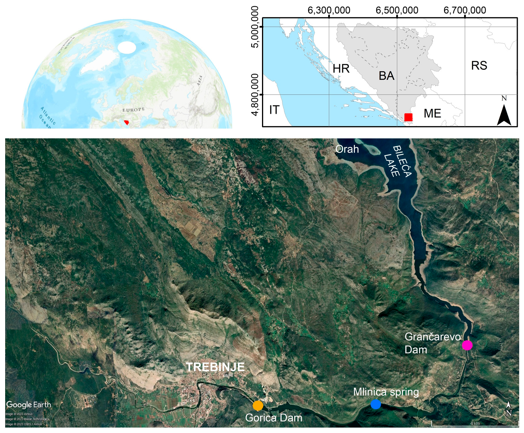
The paper presents research related to the definition of possible water losses from the right side of the Bileća reservoir, that is, the hydrodynamic characteristics of the influence of surface waters on the karst aquifer formation along the right bank of the reservoir. In general, the entire concept of the Trebišnjica Hydrosystem assumes that the impermeability of the right side of the Bileća reservoir is high, and therefore the sustainability of this system would be consistent, as well as the sustainability of the abundant use of karst groundwater. It was necessary to confirm the positive role of the dolomite anticline as a regional hydrogeological barrier, and to determine its role in the maintaining a high water capacity level of the right bank of the Bileća reservoir. Although the positive function of the Lastva dolomite anticline was confirmed during a long period of research and exploitation of the Bileća reservoir, the discharge of the Mlinica Spring formed in the karst and other similar karst springs on the right bank was hypsometrically lower. The Gorica reservoir was never investigated in detail. In particular, neither was the possibility that these springs represented drainage zones for water leaking from the Bileća reservoir, as well as collapse zones at the Orah location (the right side of the reservoir area), and their connection or disconnection through the karst underground [
4,
7,
8]. The assumptions made with regard to the water capacity and functioning of the karst aquifer of the right bank of the Bileća reservoir are shown through the results of the observation of the comparative functioning of the karst aquifer, i.e., the groundwater level fluctuation and the reservoir (water level) itself. Observations of the groundwater level oscillations indicate that there is a good hydraulic connection between the Bileća reservoir and parts of the karst aquifer on the right bank and yet, in remote parts of the karst aquifer on the right bank (piezometers B-2, B-3, M-2, M-3, and B-4), the impact of the accumulation is quite variable, due to complex lithostratigraphic features and a tectonic structure. The hydrogeological characteristics of the functioning of this part of the aquifer have not yet been clearly defined. Based on earlier data, when the reservoir levels are lower than 360 m above sea level (a.s.l.), the restoration of the GWL to its natural state also occurs in that part of the aquifer.
During the phases of the design, research, and construction of the Bileća dam and reservoir, but also after the hydrosystem was put into operation, some standard and specific research methods were applied, and some of them are given in this paper. For example, speleological investigations were applied for the purpose of defining the place of potential water leakage and the interconnection of the water levels in the reservoir and the karst groundwaters in the wider vicinity of the dam. On the other hand, in the long history of research of this area, the application of exploratory drilling, dye-tracing tests, and thermometric, isotopic, and hydrological studies has taken place in order to form a regional hydrogeological conceptual model, define the directions of the groundwater circulation, and determine the stability of the dam, especially considering the aspect of water leakage through the dam body. All the results of this research were focused on deciding on remedial measures [
4].
3. Results
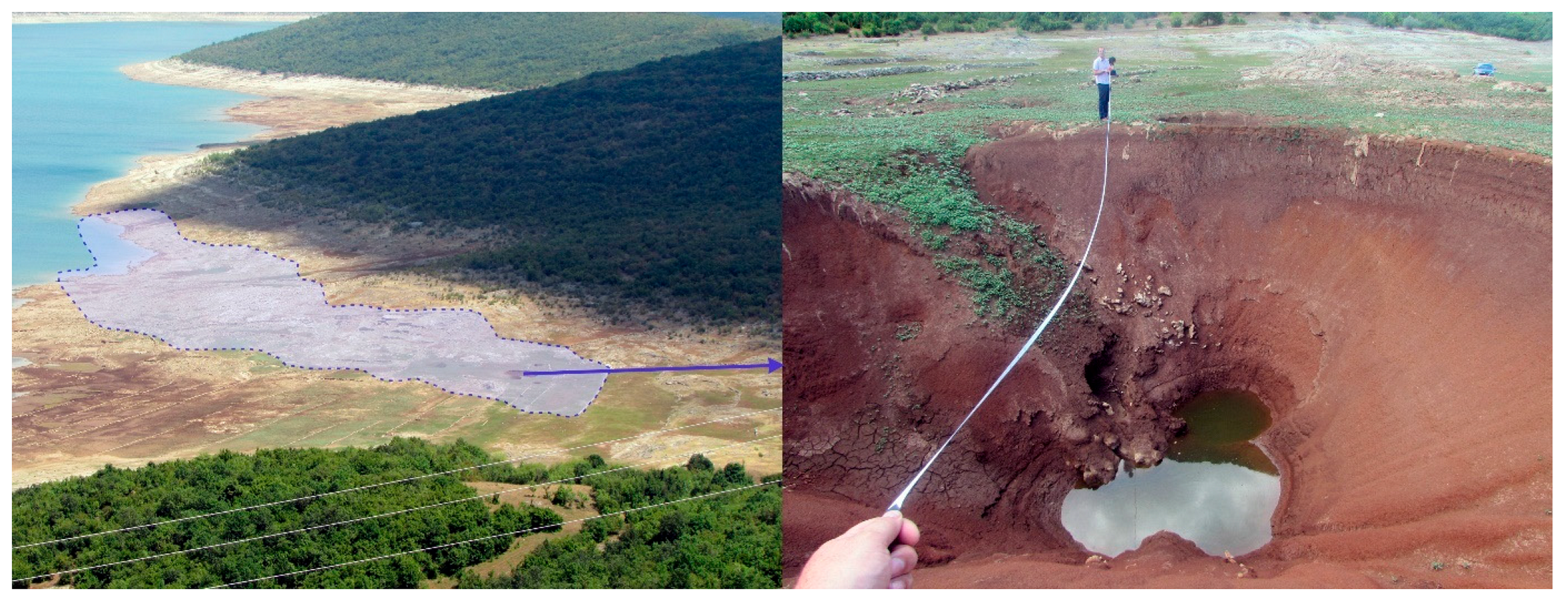
The Orah collapse zone stands out as a potential location of water leakage from the reservoir, based on the total of 12 registered collapses in the area, which belong to the right side of the Bileća reservoir [
4] (
Figure 4).
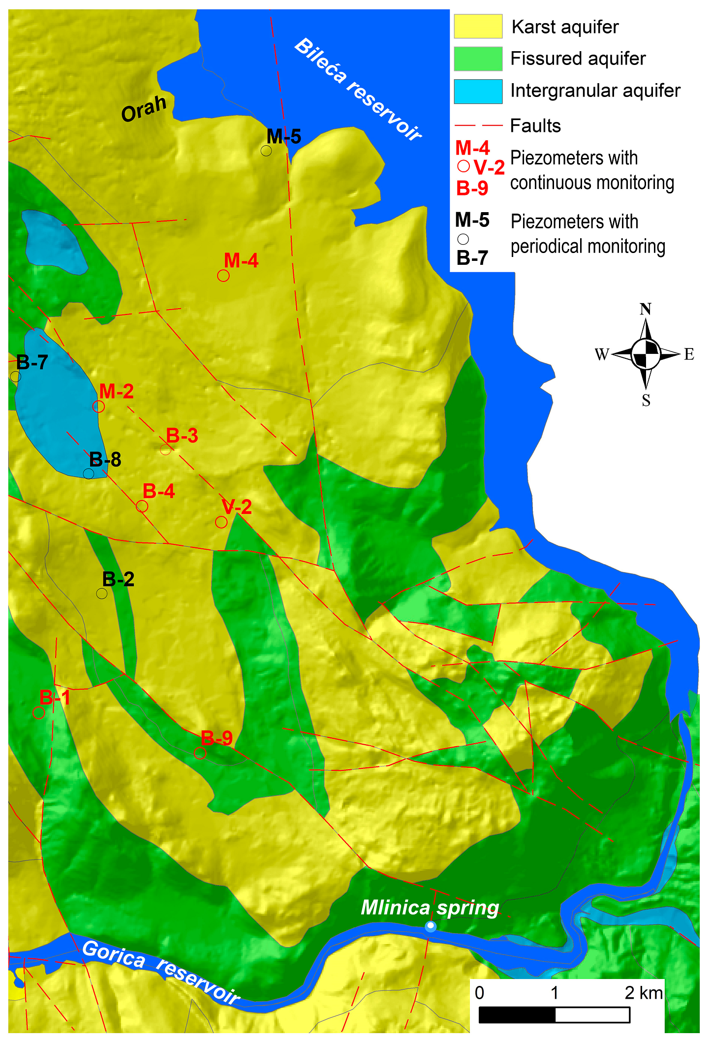
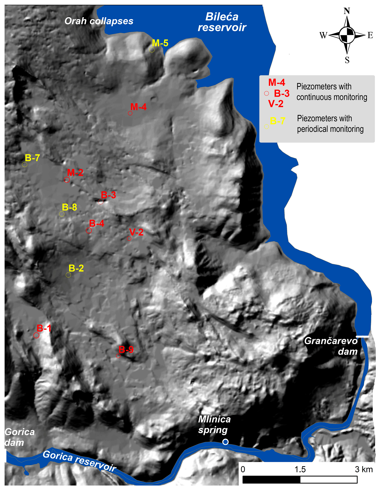
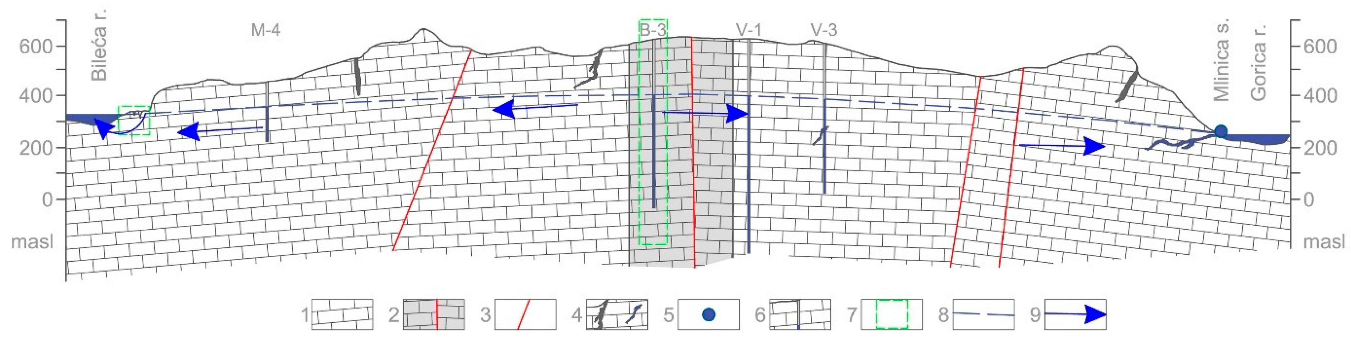
In the second zone, between Orah and the Mlinica Spring, the hydrogeological characteristics analysis was based on the data collected on the groundwater level oscillation from six selected piezometers (
Figure 2 and
Figure 3), as well as the water levels in the Bileća reservoir and the data on Mlinica Spring.
The discharge zone of Mlinica Spring is presented in the highest drainage zone by a horizontal cave with a length of 200 m, which continues further through a lake and a siphon channel. Based on its hydrogeological characteristics, Mlinica Spring is considered to be one of the main drainage zones on the right side of the Bileća reservoir, as well as all the other springs at a lower hypsometric level, which fully corresponds to the precipitation and groundwater oscillations of this karst aquifer.
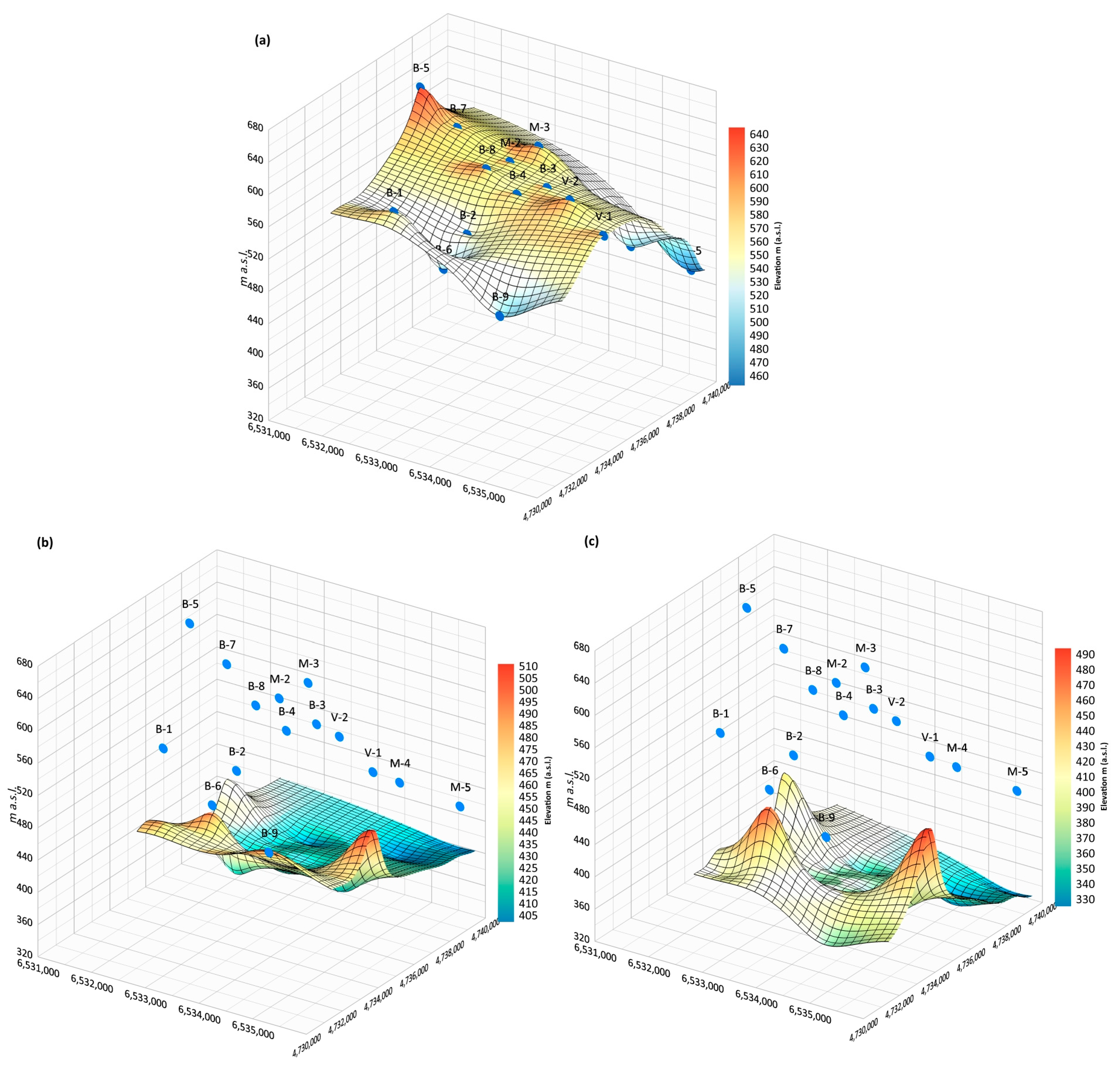
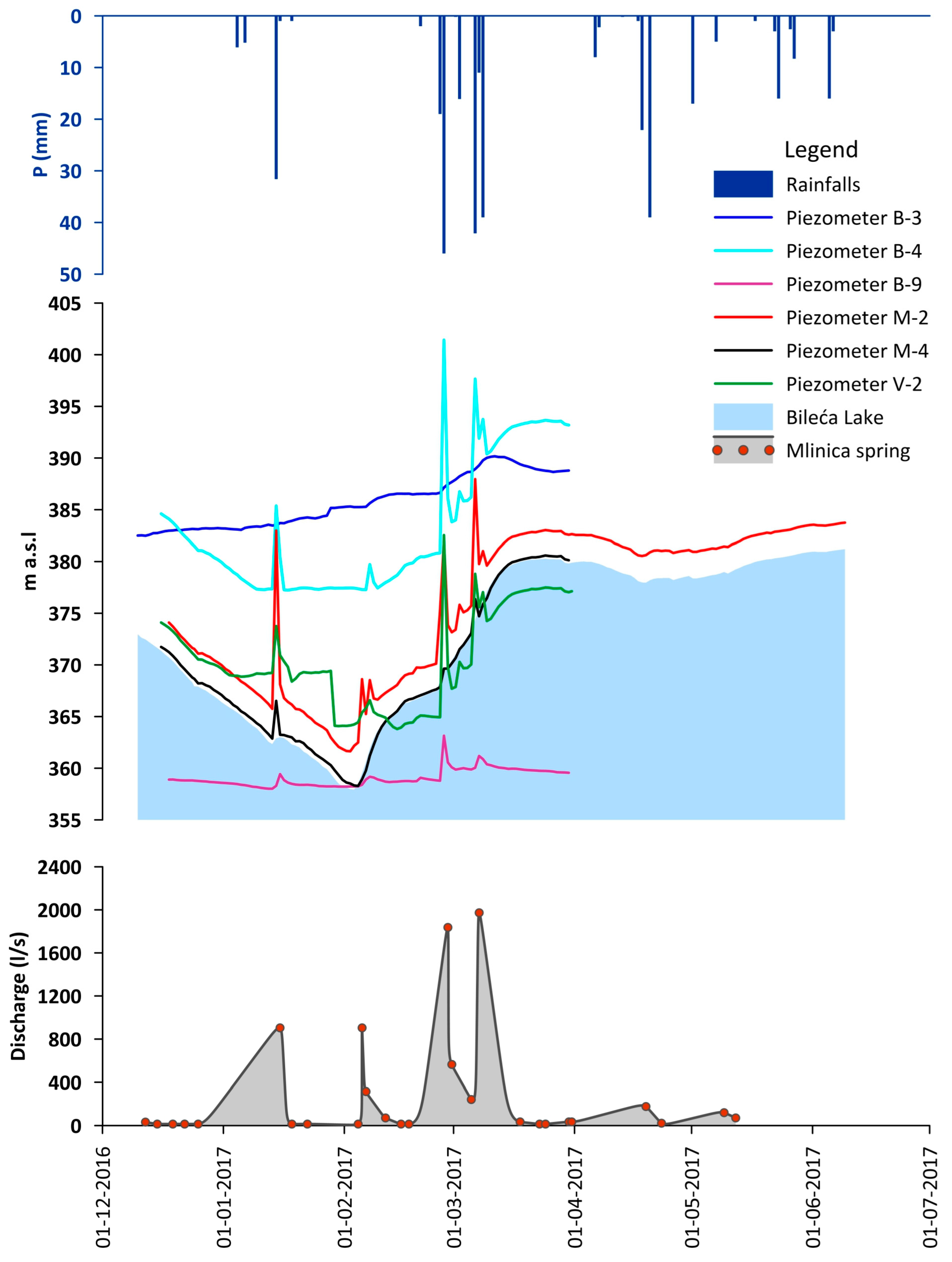
All the data collected from the piezometers on the right bank of the Bileća reservoir were analysed through the karst aquifer functioning model during periods of high and low water (
Figure 5). Detailed monitoring, along with other hydrogeological research, also included observations of the groundwater fluctuation in the karst aquifer, as well as the water level oscillations in the reservoir, for the period from November 2016 to June 2017. To compare the karst aquifer behaviour in relation to recharge, precipitation (rainfall) data collected from a rain gauge station at the Grančarevo dam were also used. The groundwater level (GWL) monitoring data, rainfall data, water level data in the Bileća reservoir, and Mlinica Spring discharge data are shown in
Figure 6, where their mutual correlation can also be observed.
From the presented charts, it can clearly be observed that, apart from the GWL in piezometer B-3 and piezometer B-9, the GWL in all the other piezometers had a significant connection with rainfall, as well as influencing fluctuations in the reservoir water levels and Mlinica Spring discharges. The increase in the GWL in the piezometers fully corresponded to the increase in the Mlinica Spring discharge rates, so that these changes occurred practically with no delay. In addition, as expected, the water level in the Bileća reservoir oscillated in exactly the same way as the GWL in the karst aquifer in the hinterland.
The GWL in piezometer M-4 fully corresponded to the fluctuations of the Bileća reservoir water levels, but did not show reaction in terms of increased precipitation; on the other hand, the GWL in piezometer M-2 also correlated with the reservoir water levels, which increased almost instantly following a precipitation event. Afterwards, the GWL dropped to “normal levels” that corresponded to the water levels in the reservoir. Like M-2, the GWL in piezometer V-2 had a good connection with the water level in the Bileća reservoir until a precipitation event occurred, after which, there was some discrepancy between the GWL and reservoir water level, which gradually decreased over time.
If the GWL in piezometers B-4, M-2, and V-2 is taken into consideration and compared with precipitation events, it can be observed that two precipitation events (4–6 January 2017 and 20 February 2017), which were noted at the Grančarevo dam measuring station, were not followed by a GWL increase in these piezometers. On the other hand, there was one significant GWL increase (3–9 February 2017) that was not, on first observation, a consequence of precipitation. These events imply that the data from the measuring station did not reflect the real-time conditions of the whole research area all of the time. Thus, it must be concluded that, in all three stated periods of time, precipitation existed, only it did not have the same effect on the groundwater levels in the whole area between Orah and Mlinica Spring.
The very high positive correlation between the GWL in the piezometers and the Mlinica spring discharge (
Figure 5) clearly indicates that the spring zone and its catchment had a perfect connection with the karst aquifer of the right side of the dam. In order to support the aforementioned facts, tracer tests were conducted. These tests confirmed the strong connection between the water level in the Bileća reservoir and the GWL in the karst aquifer on the right side of the dam. Tracer tests were conducted to confirm the previously stated assumption that the groundwater circulation of the karst aquifer of the right bank of the Bileća reservoir has a strong connection with the water levels in the Bileća reservoir [
4,
25], as well as with the geological conditions of the whole terrain and the amounts and schedules (patterns) of precipitation.
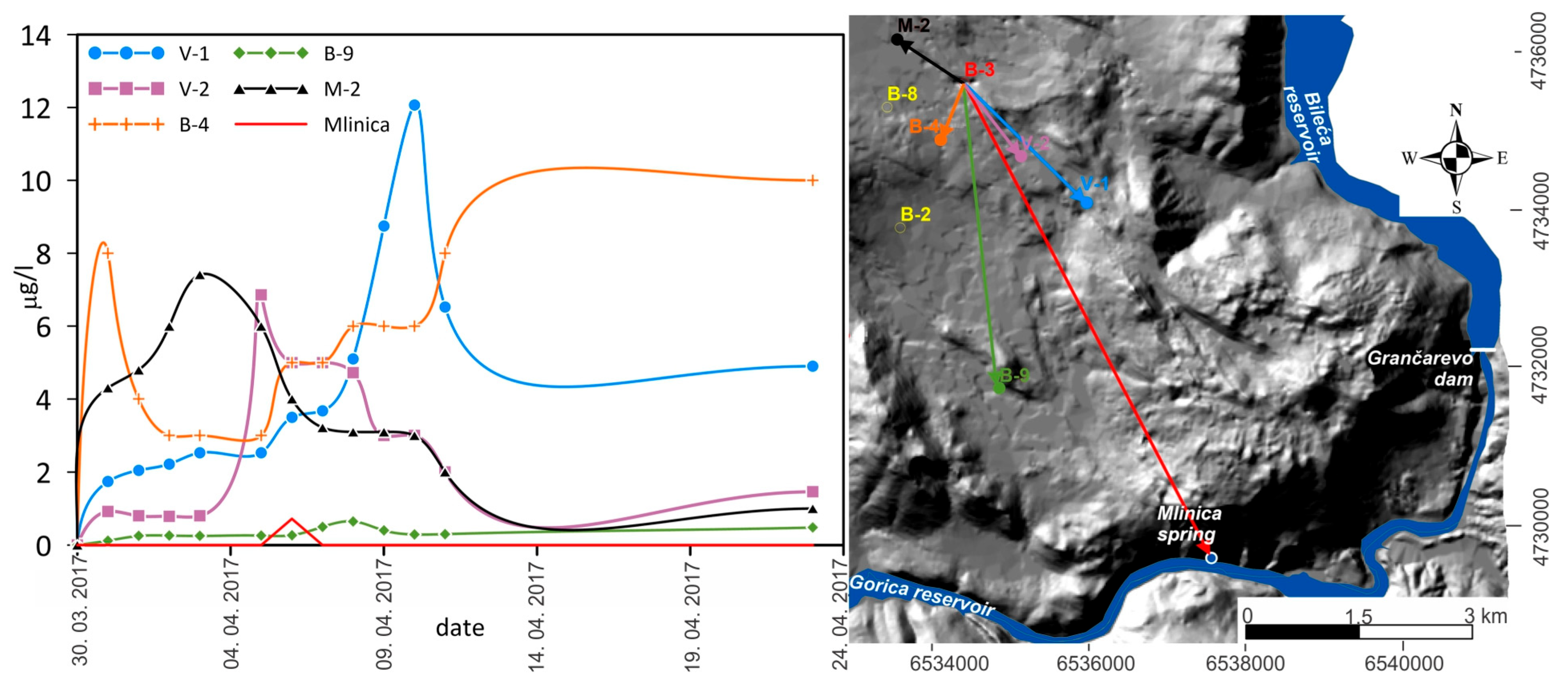
The results of the tracer tests are given as follows. The tracer was detected at all the observation stations and Mlinica Spring (
Figure 7). As can be seen, the first appearance of the tracer at all the piezometers was measured in the first sample, while the highest concentration was observed in piezometer B-4, which is “logical”, since it is the closest to piezometer B-3 (
Figure 7). The highest concentration during the monitoring was measured in piezometer V-1, in a sample that was taken on 10 April. The lowest tracer concentration was measured in piezometer B-9, which is the farthest from the injection point. Furthermore, the samples taken at Mlinica Spring showed that the tracer appeared in only one sample, 7 days following the dye tracer injection, in a concentration of 0.72 × 10
−9 mg/L [
4].
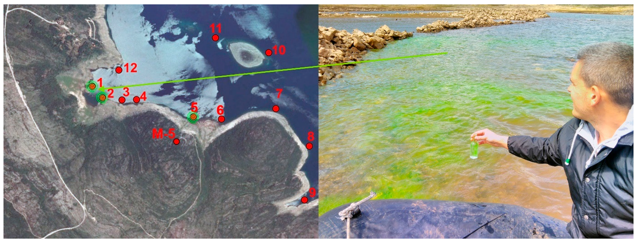
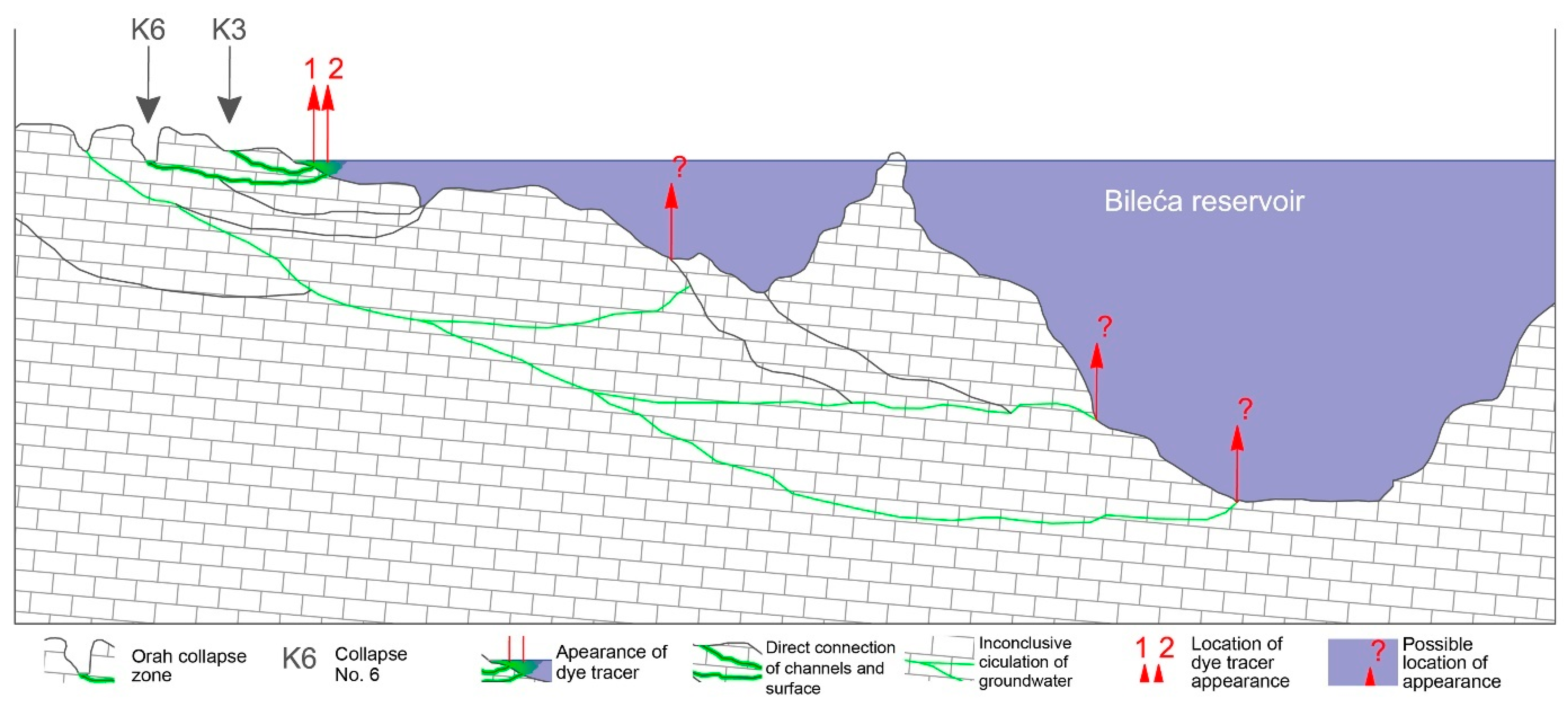
The second campaign of the tracer test was carried out in the collapse zone (
Table 1) at the Orah location on 20 April 2017. Originally, it was planned to carry out the experiment in a period of high water levels, i.e., when the accumulation level was above the Orah collapse zone, when it was considered that the best results would be achieved in terms of defining the sinking and circulation of the groundwater throughout this zone. Unfortunately, the second half of 2016, as well as the beginning of 2017, was “very dry”, i.e., no significant rainfall occurred until April 2017, and the reservoir was not filled to the necessary elevation of 382 m a.s.l. (
Figure 8). Thus, it was decided to perform the experiment with pouring water into the collapses after the dye tracer, similar to the test conducted within piezometer B-3. In each of the six smaller collapses, 0.8 kg of dye was dissolved in water and poured, and in the small collapse near the accumulation, 0.5 kg of dye was dissolved in water and poured, while 1.5 kg of paint was added to the largest collapse (Collapse K6). In total, 6.8 kg of Na-fluorescein was injected into 8 collapses (out of the 12 detected at the Orah location,
Figure 8). The injection of the dye tracer, in quick succession, and the pouring of 18 m
3 of water per collapse (and 72 m
3 of water was poured into the largest collapse), was conducted for 4 h on the same day. The tracer tests showed the reappearance of the tracer in the Bileća reservoir only at several sites (
Figure 9), and an absence of the tracers in the monitoring piezometres (M-5 and M-4). Therefore, based on these results, the hydraulic connection between the Orah collapse zone and the right bank of the Bileća reservoir cannot be proven under the minimal water period, when the tracer test was carried out [
4]. According to the obtained results, it can be only proved that the groundwater with an injected dye tracer circulated through the karst channels towards the local erosion base, i.e., the old riverbed of the Trebišnjica river (
Figure 10), and that it appeared in locations where there was a direct connection of the channel with the surface.
All the results clearly point out the reorientation of the groundwater circulation in different hydrological conditions within the karst aquifer of the right side of the dam. Furthermore, these results lead to the conclusion that the water leaked from the reservoir, first recharged the karst aquifer, and then went to Mlinica Spring, which is very suspicious [
4] (
Figure 11).
The discharge from Mlinica Spring during the monitoring period ranged from a few cubic meters to 5 L/s, which was recorded on 18 July 2015, while it dries up during very long dry seasons. As already mentioned, Mlinica Spring emerges from a cave that is located about 15 m above the maximum water level in the Gorica reservoir. A horizontal cave exists in the highest drainage zone, where a length of 60 m was examined during the preliminary reconnaissance. Detailed research was conducted and further channels were explored by speleo diving up to the siphon lake. In total, 90 m of new karst channels were recorded. Even though the cave is located well above the probable primary zone of discharge, during the dry period, a smaller, active flow was registered within it, as well as larger cave lakes further into the system.
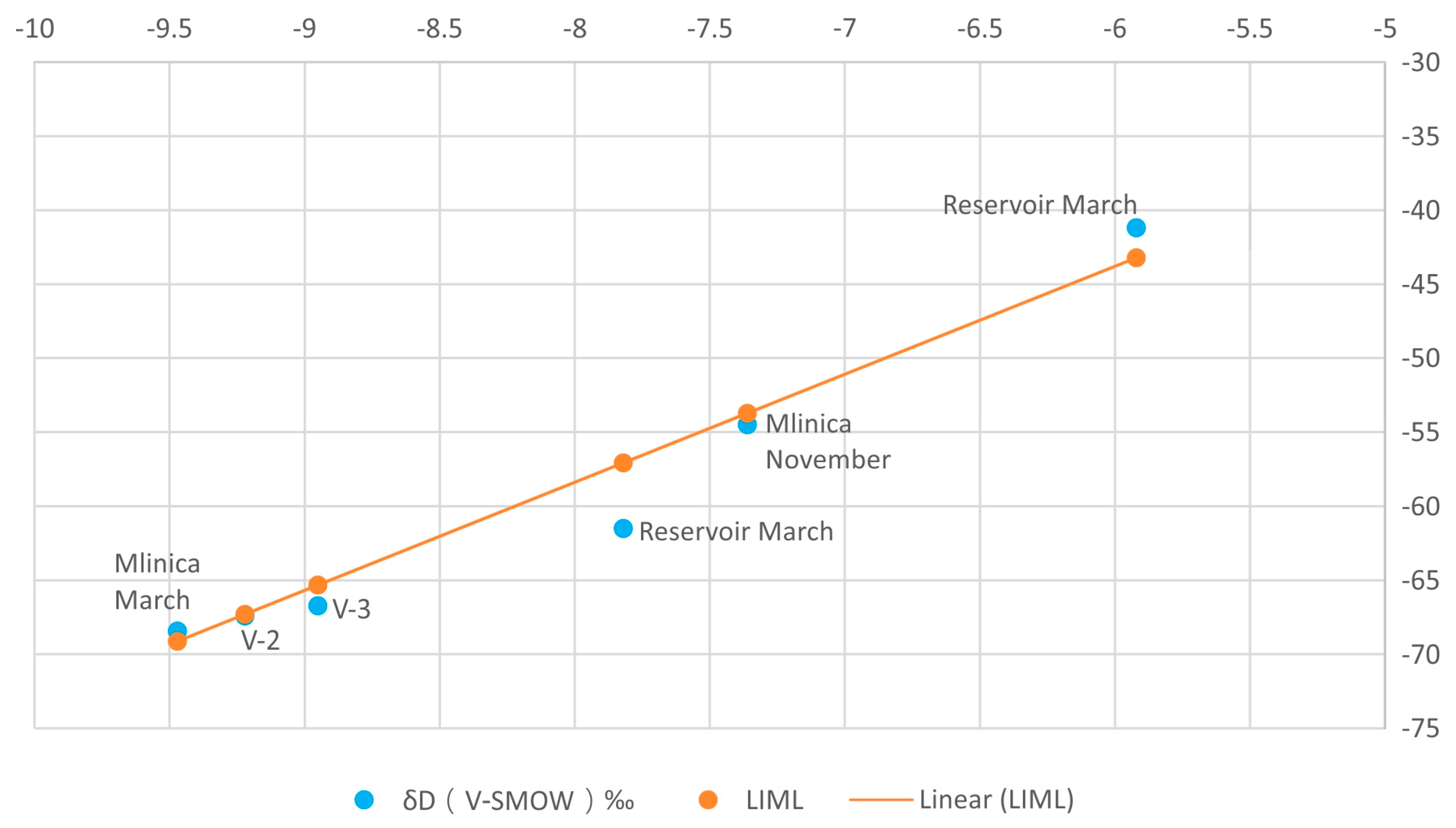
According to the stable isotopes, oxygen
18O and deuterium
2H, it can be concluded that there is a strong relationship (
Figure 12) between precipitation and the groundwater discharging from Mlinica Spring (in both measured cycles), as well as a strong relationship with the groundwater from piezometers B-3 and V-2, given that the measured values from these locations are plotted very close to, or almost on, the LML. The reservoir waters do not fit directly on this line, which is a consequence of pronounced primary fractionation, i.e., strong evaporation from the surface of the lake, where, due to the weaker connection of the lighter isotopes, they are primarily fractionated, leaving a heavier isotopic composition of oxygen and hydrogen in the lake. Strong winds, which are very pronounced in this zone during autumn and winter, also help the separation and fractionation of the lighter isotopes of oxygen and hydrogen from the surface of the lake.
A rough conclusion can be drawn that the groundwater from Mlinica Spring is not directly related to the waters from the reservoir, as well as that this groundwater (Mlinica and piezometers B-3 and V-2) is strongly related to precipitation, which speaks of a diffuse recharge of the karst aquifer and rapid underground circulation. In order to confirm these claims, it is necessary to sample water from the reservoir at different depths, as opposed to only sampling the surface layer that is exposed to fractionation.
The isotopic analyses of T + 3He (0.187 TJ in average) of the groundwater from Mlinica Spring showed that karst groundwater in the right bank of the Bileća reservoir was very young, and that these waters are constantly connected with rainfalls. The age of the groundwater, in all the samples taken, ranged from a few days to a few months. The highest value of tritium was observed in the reservoir, which reflects the content of the isotope in the precipitation on the territory of Europe. When tritium enters groundwater, its decomposition begins, resulting in slightly lower observed values in groundwater than those observed in surface waters, which range from 5.7–7.8 TJ, indicating young water up to five years old.
All the applied methods, their results, and the daily groundwater monitoring data of the piezometers and Mlinica Spring discharge supported the fact that there is no significant water leakage from the Bileća reservoir in regular hydrological conditions. On the other hand, the correlation between the GWL data from the piezometers and Mlinica Spring discharge points out that the zone between the Orah collapse area and Mlinica karst spring discharges on the Mlinica Spring and other small springs along the right bank of the Bileća and Gorica Reservoirs, as well as directly into the Bileća (Gorica) reservoir [
4].
4. Conclusions and Discussion
Based on all the collected and analysed data and the design of 2D and 3D spatial models, as well as the previously processed hydrodynamics of the karst aquifer, a complete spatial model of the karst system behaviour, in conditions defined by low and high levels of groundwater and low and high levels of the reservoir lake, was produced. The assessment and integration of all the data into one model gave results according to different types of combined conditions that prevail in the karst aquifer, and in relation to the influence of high or low waters of the reservoir lake. For such a model formation, a model of real conditions defined during the research period from November 2016 to June 2017, called (Combined model 1), was used as a reference model. This, and other combined models of karst aquifer functioning dependant on the water levels in the reservoir and GWL, are given through four models:
Combined model 1—low reservoir water levels and low GWL (benchmark model—defined during research);
Combined model 2—low and medium reservoir water levels during floods, i.e., high GWLs;
Combined model 3—high GWL and maximum reservoir water levels;
Combined model 4—high reservoir water levels during the recession period, low GWL possible only in the conditions of the fully operative Upper Horizons (artificial conditions).
The first combined model (1) refers to the conditions of low reservoir water levels and low GWLs in the karst outcrop. These conditions prevailed throughout the entire research period. As can be seen from the obtained data, the connection with the karst aquifer is fully reflected by the data obtained from piezometer M-4 (the observed piezometer closest to the reservoir), while the data from piezometers B-4 and M-2 also followed the behaviour of the reservoir, but with considerably higher GWLs than the reservoir water levels.
On the other hand, the data of piezometer B-3, with the highest groundwater levels, indicated that a hydrogeological watershed may exist in that zone (
Figure 4 and
Figure 7). Piezometer B-3 is located on the route of a large fault, which extends in a SE–NW direction. In addition, piezometer B-9, which has the lowest groundwater levels, did not correspond to the water level in the reservoir, which indicates that its hydrogeological activity is related to dolomite and dolomitic limestone. Piezometer V-2 also indicated a zone of possible water redistribution, that is, it did not reflect the state of the reservoir water level.
The data obtained from the investigative works at the Orah collapse area did not indicate the possibility for water loss from the reservoir under such hydrogeological conditions. The conclusion is that, under these hydrological and hydrogeological conditions, the aquifer discharges at Mlinica Spring and therefore, it can also be concluded that the groundwater discharge at Mlinica Spring has nothing to do with the surface water from the reservoir, but rather the groundwater from a large karst aquifer that covers about 80 km2.
Combined models 2 and 3 are certainly not problematic and cannot affect the water loss from the reservoir, since these are about a high karst GWL on the right bank of the Bileća reservoir.
Unlike the models shown above, only the combined model 4 for the conditions of high water levels in the reservoir and a low GWL in the karst aquifer can cause leakage from the reservoir to the karst aquifer and further towards Mlinica Spring. Certainly, achieving this state during natural conditions and conditions of the normal functioning of the hydroelectric power plant “Grančarevo” is almost impossible (full reservoir at the end of the dry recession period). In such a case, the water level of the reservoir would be around 400 m a.s.l, while the groundwater levels in the piezometers would be 385 m a.s.l., i.e., significantly lower. Such levels would create conditions for water from the reservoir to infiltrate into the flanks of the reservoir, i.e., into the karst aquifer and circulate in the named zone towards Mlinica Spring. This condition is generally possible only in the working conditions of the Upper Horizons (artificial conditions). That is, when the reservoir would be filled from the higher-elevation reservoirs of the Upper Horizons during the recession period.
The main conclusion, which must be confirmed by a longer series of measurements of the GWL in all the piezometers on a daily basis, including the Mlinica Spring discharge, is that, under regular hydrogeological conditions, there is no significant water leakage, while on the other hand, the karst aquifer of the right bank of the reservoir, from the Orah collapse zone to Mlinica, drains mostly through the Mlinica Spring, and a smaller part of groundwater discharges into the Bileća reservoir.


