2. Materials and Methods
The Krupaja system represents one of the most complex karst systems within the Beljanica karst massif, and as such, it is of great importance for the study of karst groundwater genesis, the depth of cold, subthermal, and thermal groundwater karst channels, and groundwater mean residence time.
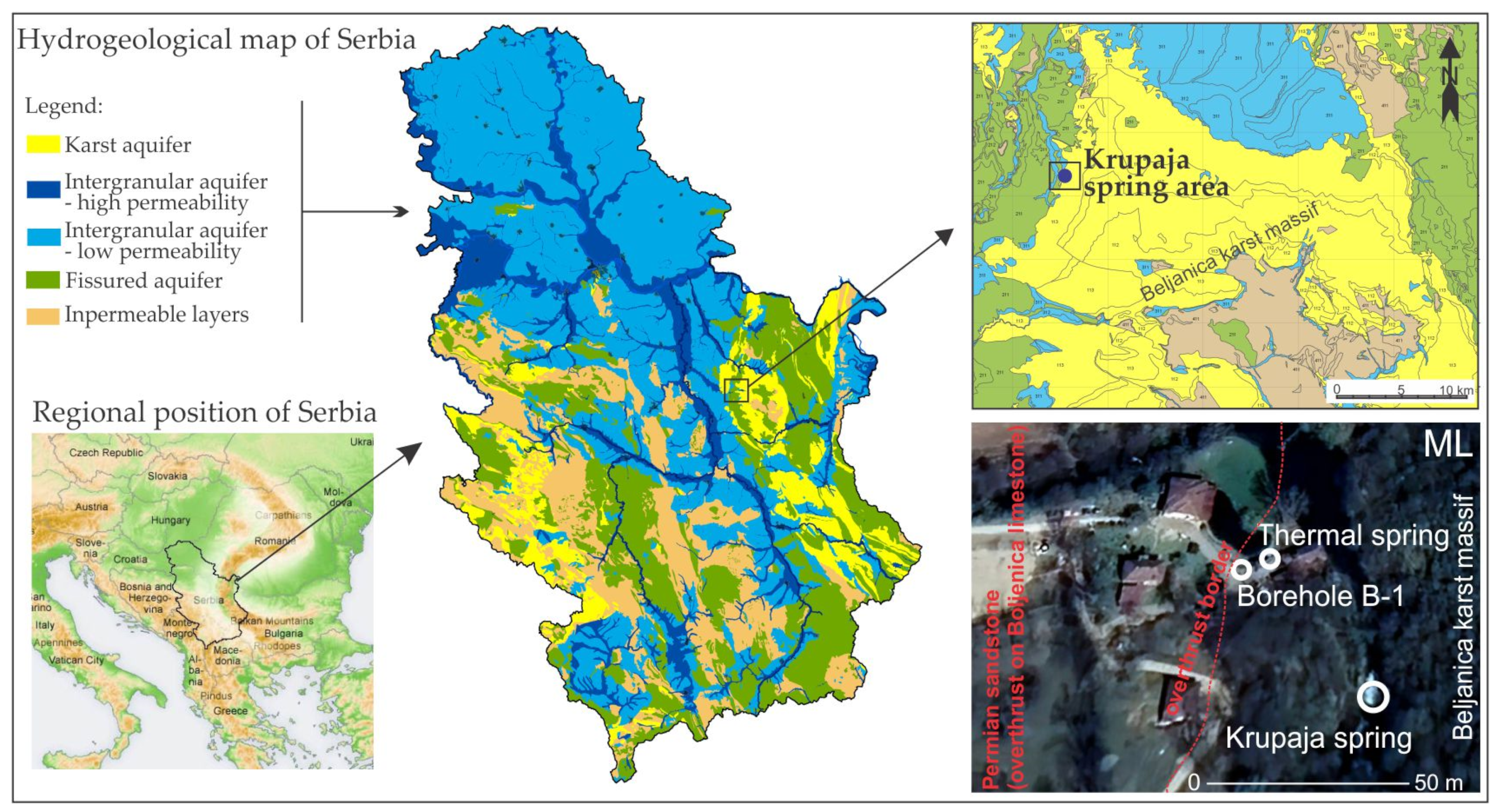
The complex karst system is located on the western edge of the Beljanica Massif, in the eastern part of Serbia, within the Carpatho-Balkanides karst. The complex karst aquifer is mostly drained via the strong Krupaja karst spring, whose temperature is stable and ranges from 10 to 12 °C, and, to a lesser extent, via the Krupaja thermal spring, with a constant temperature of 26 °C, in addition to discharges via an artesian borehole with a temperature of 18 °C (
Figure 1).
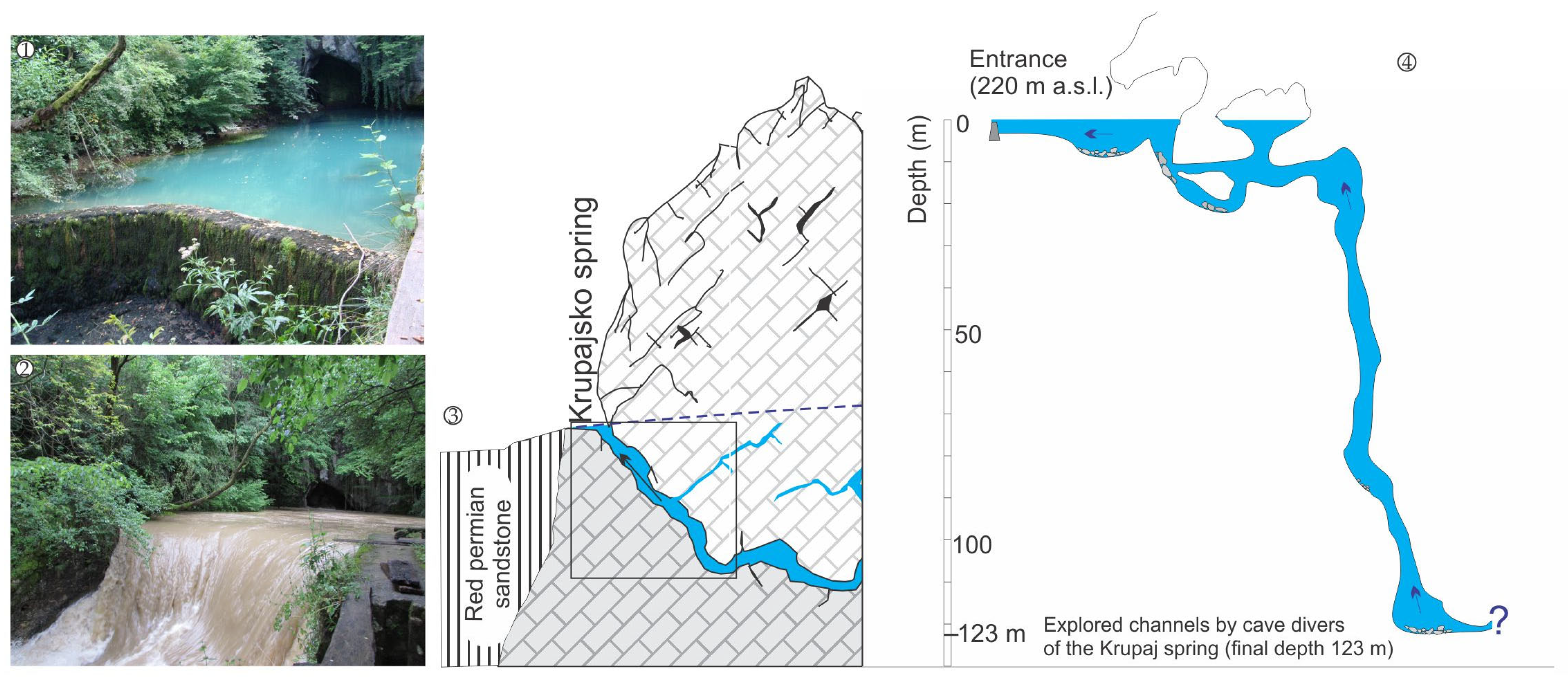
The Krupaja Spring is a strong spring of the ascending type, formed in a zone of red Permian sandstone overthrust over Urgonian limestone, which drains the Beljanica Massif at an altitude of 220 m above sea level. Water drains out from the cave, whose channels are predisposed by the NE–SW fault. The shallower channels go down to a depth of 20 m, and after 70 m, they exit into a dry siphon hall, while the deeper channel, according to the latest research, goes down to a depth of 123 m [
7]. The quantity of water drained from this spring varies seasonally (0.160 m
3/s to 8.776 m
3/s), and the maximum capacity was recorded in a period of flooding in 2014, when an amount of approximately 31 m
3/s drained out from the spring [
12] (
Figure 2).
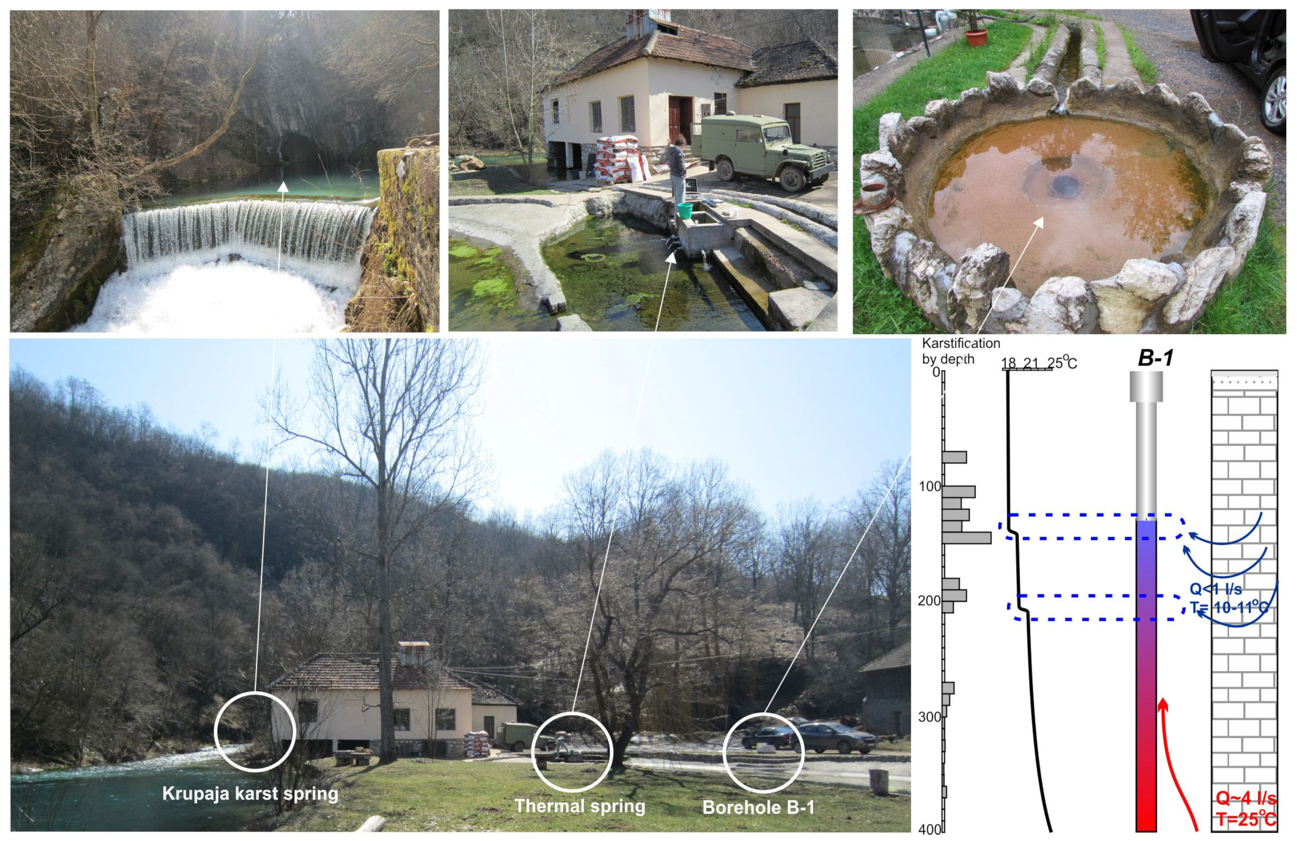
As previously mentioned, the thermal spring of the Krupaja system has a temperature of 26 °C, making it the natural spring with the highest groundwater temperature (thermal) within the Beljanica Massif, which is why determining the age of this spring was of great importance for defining the conditions of groundwater formation and the depth of groundwater circulation. The thermal spring is located at a distance of about 50 m from the cold Krupaja Spring; it emerges at an altitude of 215 m above sea level, at the contact point of the Red Permian sandstone overthrust over the Urgonian limestone; it has an ascending type of circulation with a constant capacity of about 2 L/s. In the 1980s, borehole B-1 was made to a depth of 400 m in the immediate vicinity of the natural thermal spring in order to access larger quantities of thermal waters [
13].
At a depth of 383.5 m, a temperature of 25 °C was detected, which is one degree lower than the temperature of the natural thermal spring. However, since the borehole cuts through some of the main karst channels containing cold water, the water temperature from the borehole, with a capacity of 5 L/s, is only 18 °C. Additionally, with regard to the hydrochemical characteristics of the water, an increased content of certain trace elements (Al, Fe, Mn, SiO
2, etc.) was detected, similar to the chemical composition of the water at the natural thermal spring of the Krupaja system [
14].
Figure 3 shows in detail the layout of the springs and the borehole (Krupaja Spring, thermal spring, and borehole B-1).
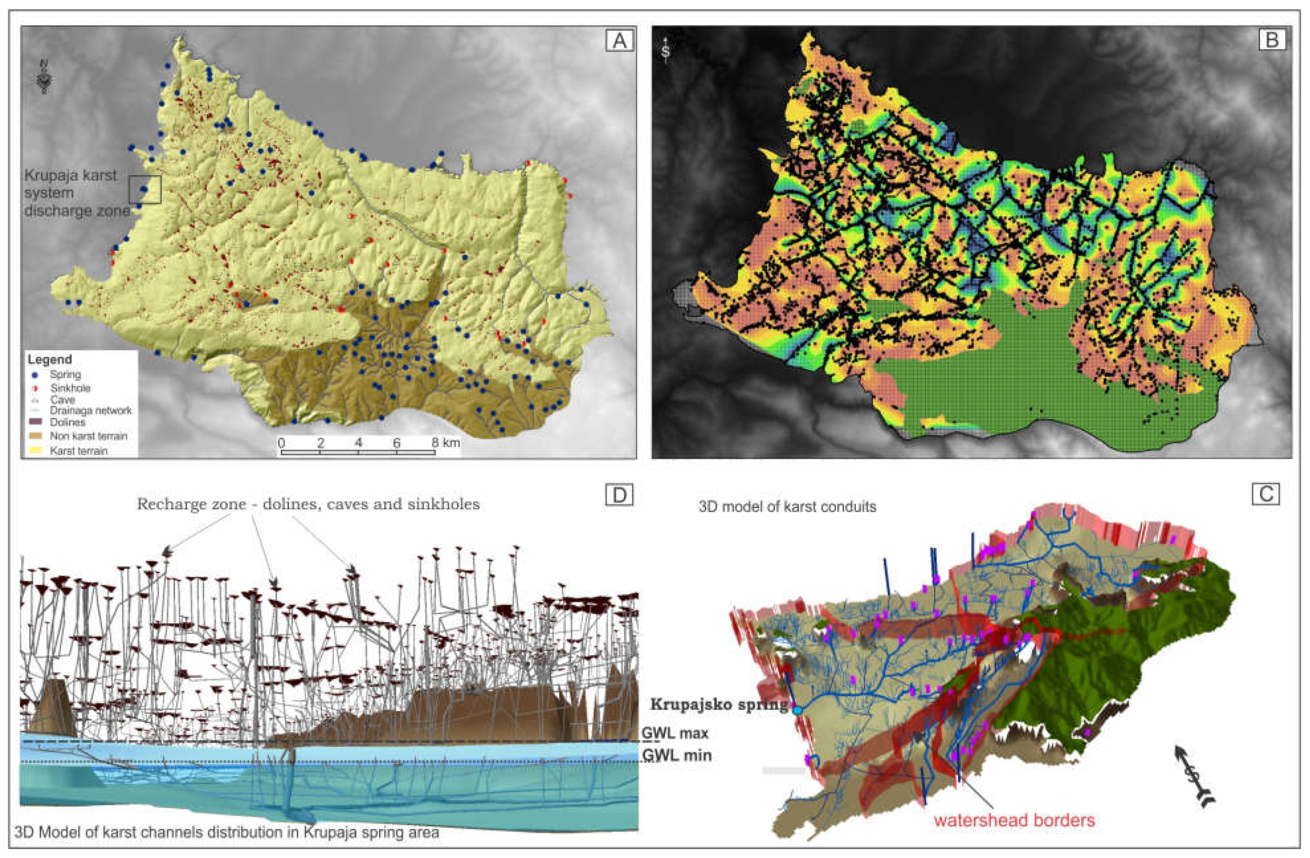
For the purpose of defining the genesis and water circulation conditions of the two karst springs and the borehole within the Krupaja system, a multi-parameter research concept was applied. Previous research was focused on creating a spatial model of the Krupaja Spring karst channel distribution, i.e., through investigation of the part of the karst aquifer in which rapid circulation and water exchange takes place, the part of the aquifer that depends strongly on recharge. The results of this research have been processed and published several times in scientific journals and chapters of monographs [
15,
16,
17,
18], and this paper will only present an overview of the obtained results and conclusions as an introduction to new and supplemental research. The above-mentioned research and analyses led to preliminary findings regarding the type of groundwater circulation within karst aquifers with highly developed karst channels. The results of this research suggested possible development mechanisms of these karst channels and indicated that they may function as part of an aquifer that is completely dependent on recharge and whose circulation takes place through large and well-developed karst channels. This model of karst channels, its spatial position and dependence in relation to recharge and discharge, indicates a very complex and well-developed karst system. For the purposes of forming the model, as shown in the following text, a large number of data, obtained primarily from field hydrogeological, geological, speleological, speleo diving, and other research techniques, were used.
The input data of the model represent real research data from 69 caves, 15 sinkholes, 1682 dolines, 7 major karst springs, and around 70 minor springs, as well as geological, morphological, and hydrogeological data connected to the investigated area, Beljanica Massif. As 2D output from the model, more than 6000 datapoints were calculated and registered in the database (
Figure 4A). There are 60 different datapoints for each position (coordinates, groundwater level, channel types, channel dimensions, next point of conduit, connection with conduit, channel orientation, hydrogeological function, etc.). Ultimately, the model was based on more than 360,000 data items [
7]. The 2D model mesh is shown in
Figure 4B. For the 3D karst groundwater model, the ArcGIS program was used, along with some additional software [
7]. Linked layers and an associated base were used to create a basis for further analysis of karst aquifers through different model components. By defining the main directions and orientation of karst conduits (followed by a possible small percentage error), layers of potential 3D karst channel distribution were created. The total length of the karst channel network, which was calculated using this model and presented in a 3D environment, is 647.29 km. Detail of the model is shown in
Figure 4C. For the purposes of defining the circulation conditions within the karst aquifer that drains via Krupaja Spring, parts of the model from the recharge to the discharge zone were used (
Figure 4D) [
19].
All of the factors mentioned above explain the possible groundwater genesis and circulation conditions. However, the genesis of the channel remains unknown, as well as the genesis of the groundwater that drains at the thermal spring and through the B-1 borehole. Complex hydrochemical and isotopic research was carried out in order to resolve these complex issues and obtain more reliable data that will yield clear insights into the circulation of groundwater within the karst aquifer, which circulates much deeper than the base runoff.
Our research included analyses of the hydrochemical characteristics of the water for all three phenomena during one hydrological year (summer and autumn 2015, winter and spring 2016, basic physical and chemical characteristics and ionic composition of water), as well as determining the content of stable isotopes H,
18O, and
13C, also on a quarterly basis. Stable isotope concentrations of
2H/
1H
18O/
16O and
13C/
12C, expressed as δ
2H, δ
18O and δ
13C, were measured in the laboratory of the International Research Centre on Karst (IRCK) in China using a LGR LWIA-V2 water isotope analyzer and a MAT253 stable isotope mass spectrometer, while ion contents were measured with an ion chromatograph (IC) Dionex ICS-900 [
12]. The hydrochemical and isotopic characteristics of the water were determined with the aim of establishing a hydraulic connection of the groundwater based on the similarity of the results, thereby confirming that this water belongs to the same karst system. The results were associated with groundwater changes related to increases in the depths of the karst conduits and the mean residence time.
In order to determine the age of the groundwater, radioactive isotopes tritium, T+He, and
14C were used; tritium content was determined at all three locations. The T+He method was carried out only at the cold Krupaja Spring with deep siphonal circulation, while the age of the Krupaja thermal spring was determined using the
14C method with age correction using the
13C/
12C content in the rock and water sample. Samples for tritium,
3H +
3He, and noble gas content analysis were transported to the laboratory of the Institute for Nuclear Research, Hungarian Academy of Sciences Bem tér 18/c, 4026 Debrecen, Hungary, where they were prepared and analyzed using a VG5400 noble gas mass spectrometer [
19,
20]. Sampling for groundwater age-dating of the cold Krupaja Spring and thermal spring was carried out during the summer period, i.e., the period of recession, when it was considered that the water that had spent the most time underground was being drained.
3. Results
The largest quantities of water are constantly being discharged from the Krupaja spring, which speleogenetically belongs to the group of deep siphonal springs, with a capacity that varies from 0.16 m3/s to over 31 m3/s. The second spring of the investigated system involved thermal groundwater that is only 7–8 m away from the borehole and has a flow rate of 2–2.5 L/s, while subthermal water drains from borehole B-1 and has a constant discharge rate of 5 L/s.
Water temperatures are uniform and increase with depth, so the water temperature at the Krupaja Spring ranges from 10 to 11.4 °C, expressing its seasonal characteristics. The highest water temperature of 11.4 °C was recorded during the summer period, which may be a consequence of the intrusion of lake water, minimum discharge from the spring, and air temperatures up to 35 °C. The borehole groundwater temperature is constant at around 18 °C (18.4–18.7 °C); this water comprises a mixture of cold and thermal water. The water temperature at the bottom of the borehole reaches a value of up to 25 °C. The groundwater temperature at the thermal spring ranges from 25.9 to 26.6 °C, where lower temperatures were recorded during the spring period, indicating the injection of cold and young water into the thermal water drainage zone.
The pH values also change slightly with depth, showing a decreasing character. The highest values recorded at the Krupaja Spring were 7.44, with values of 7.3 at the borehole and 7.16 at the thermal spring. In contrast to pH value, electrical conductivity increases with depth, indicating an enrichment of mineral substances with increasing depth and temperature, ranging from 505 to 526 μs/cm at the Krupaja Spring, from 523 to 543 at the borehole, and from 543 to 560 μs/cm at the thermal spring.
Dissolved oxygen is the highest at Krupaja Spring during the spring period (10.26 mg/L), which is a consequence of the turbulent regime and infiltration of fresh water into the system. Oxygen decreases with depth, so in the well, the values vary from 4.3 to 7.45 mg/L, while the values in the thermal spring are consistently low, ranging from 1.13 to 2.61 mg/L due to a prolonged residence time within the system. A slight increase in water turbidity up to a maximum of 1.74 NTU was recorded at the Krupaja Spring during the autumn period. Such an increased value, most likely due to heavy autumn rains and the washing of surface layers, was also reflected in water from greater depths, so in the borehole water, it was 1.59 NTU, while at the thermal spring, it was 1.6 NTU. Considering that we observed the same amount of suspended particles in the water from borehole and thermal spring, it can be concluded that in the zone up to 400 m, which is equivalent to the depth of the borehole, the waters mix, i.e., they infiltrate into the discharge channel of deep thermal water. The physico-chemical characteristics of the groundwater (related to the seasons) of the Krupaja system are shown in
Table 1.
The content of stable isotope δ
13C decreases with circulation depth, indicating a higher groundwater age and longer contact with the host rock. The carbon content at the Krupaja Spring ranges from −8.20 to −10.31‰, also indicating a longer mean residence time. Meanwhile, the carbon isotope content in borehole water ranges from −5.91 to −6.81‰, while at the thermal spring, it ranges from only −2.69 to −5.32‰ (
Table 2). Higher values were recorded in the thermal spring during the spring period, which indicates inflow and mixing with younger water, i.e., not fresh surface water, but water that has had a long residence time within the system, lowering the stable carbon isotope content by up to −5.32‰.
The content of stable oxygen and deuterium isotopes also decreases with longer mean residence time, which is a consequence of isotopic fractionation, which takes place during prolonged contact with the host rock. The highest values of δ
18O were as follows: −1.04‰ at the Krupaja Spring, −10.88‰ at the borehole, and −10.28‰ at the thermal spring, which indicates a gradual decrease in the content of stable oxygen isotopes with groundwater circulation depth. Furthermore, the δD value decreases with depth, so the maximum content of this isotope was −76.43‰ at the Krupaja Spring, −74.33‰ in the borehole water, and −73.01‰ at the thermal spring (
Table 2).
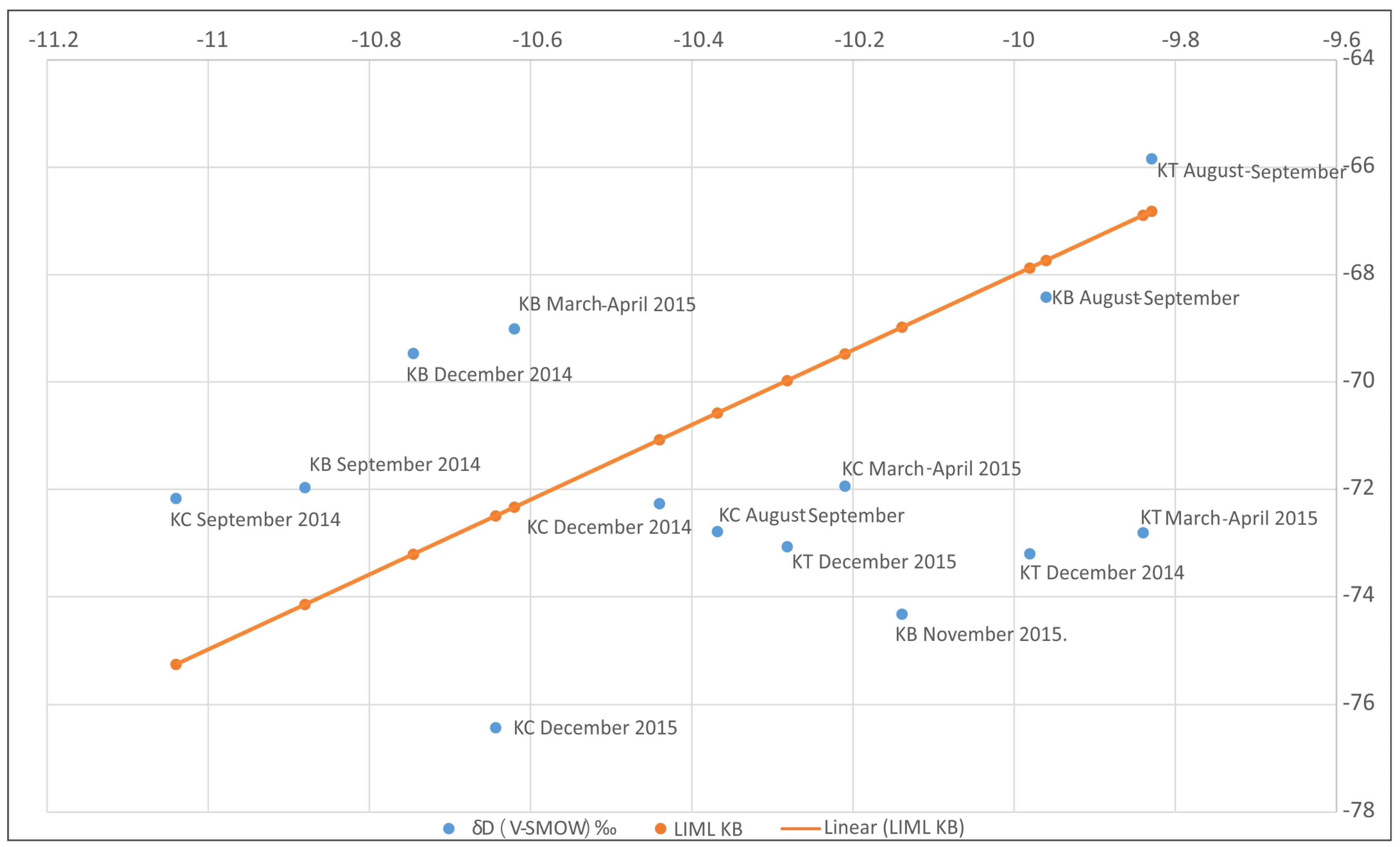
The levels of stable isotopes δ
18O and δD in the Krupaja system groundwater indicate the influence of precipitation and a good connection of surface water and groundwater (
Figure 5), with the exception of the thermal water samples, which fall below the local isotope meteoric line (LIML), indicating a longer residence time within the system and a weak connection with atmospheric precipitation.
In addition, most of the Krupaja Spring results fall below the LIML, with the exception of the sample taken in September 2014, which is above the LIML, indicating the delayed impact of heavy precipitation from the spring period, which represents a prolonged discharge of the system after the highest maximum ever recorded at Beljanica Massif in May 2014. Other samples fall close to the local isotope meteoric line, indicating a connection with atmospheric water, but also lie below the LIML, having a higher groundwater mean residence time and therefore indicating secondary fractionation.
Borehole B-1 reflects much of the content of atmospheric precipitation, so the values from September and December 2014 are above the LIML, which may indicate the delayed influence of the highest waters from 2014 on waters that percolate deeper into the system; however, it may also indicate a strong intrusion of fresh storm water into the borehole from channels that are generally not hydraulically connected to the Krupaja Spring, which was also the case with the results for the sample from April 2015. The borehole sample from the summer and autumn period of 2015 shows high groundwater age, that is, it excludes the intrusion of fresh water, which may be a consequence of the small amount of water that infiltrated into the system during the spring period of 2015 (explaining the difference in the maxima of 2014 and 2015).
In order to define the groundwater age within this complex karst system, sampling of water for radioactive isotopic content analysis of
3H,
3H/
3He, and
14C was performed during the minimum discharge period. The results of tritium content tests are shown in
Table 3 (Krupaja Spring) and
Table 4 (thermal spring and borehole). Tritium values decrease with depth; the highest are at Krupaja Spring, ranging from 5.64 to 5.7 TJ, indicating semi-young groundwater. In order to determine the exact age of the Krupaja Spring groundwater, a more precise analysis was carried out, i.e., the age of the water was calculated using the
3H/
3He isotopic method (
Table 3). According to the results, it was concluded that the groundwater age of the Krupaja Spring is 26.1 years +/− 0.7 years. The
3H/
3He method gave the highest age of the young component in the groundwater sample that was discharged during September. This indicates that the Krupaja Spring during the low flow period, i.e., during the period of recession, through the main channel, explored to a depth of 133 m, which probably lies much deeper underground, circulates groundwater with a maximum age of 26.1 years.
During the high flow period, young, freshly infiltrated water primarily flows through this channel, which, due to high hydrostatic pressures, pushes older water out; however, it can also be concluded that certain amounts of old groundwater discharge during high water periods, which can be seen from the fairly uniform water temperatures and other physico-chemical parameters observed in the Krupaja Spring groundwater in all seasons.
The tritium content in the borehole water (
Table 4), as well as in the thermal spring groundwater, is significantly lower, amounting to 3.9 TJ and only 1.7 TJ. These contents, shown on
Table 4, indicate a mixture of old and sub-modern (semi-old) water that has more recently infiltrated into the system.
The carbon
14C content of the Krupaja Spring groundwater is 74.95 pMC (
Table 5). With further calculation, together with the values of δ
13C of the water and δ
13C of the host rock for the Beljanica Massif, these results indicate that these are young, modern waters.
The content of
14C in borehole B-1 water is 52.05 pMC (
Table 5), i.e., much lower compared to that in the Krupaja Spring. However, further calculation, together with the values of δ
13C in the borehole groundwater during the sampling period and δ
13C in the host rock for the Beljanica Massif, gave the result that these are young, modern waters, with age that cannot be determined by carbon analysis, considering that this method is used for the detection of very old waters.
The content of
14C in the thermal spring of the Krupaja system is 16.89 pMC (
Table 5), which represents the lowest recorded value of this radioactive isotope of carbon within the Krupaja system and in the Beljanica Massif itself. However, by including the value of δ
13C of thermal spring groundwater and δ
13C in the host rock for the Beljanica Massif, it was calculated that the age of the water is 3990 years, which indicates that this water is the oldest in the system, but not the oldest groundwater within the Beljanica Massif (the oldest is Suvodolska Banjica, at 6000 years old) [
12].
The ionic composition of the Krupaja system water indicates that these are waters of the HCO
3−–Ca
2+ group. The content of Ca
2+ decreases with depth; the highest values were recorded at Krupaja Spring, ranging from 3.92 to 52.39 mg/L. Slightly lower values were recorded at the borehole (27.85 to 39.81 mg/L), while the lowest values were observed at the thermal spring (22.69 to 37.23 mg/L). The lower calcium values in the subthermal and thermal waters are explained by the different hydrogeochemical conditions that prevail at greater depths, as evidenced by other ions contained in the waters of the Krupaja Spring. The content of HCO
3− increases with depth, ranging from the maximum values at the Krupaja Spring of 163.78 mg/L, through the maximum value at the B-1 borehole of 170.29 mg/L, to the maximum recorded value at the thermal spring, i.e., 211.57 mg/L (
Table 6).
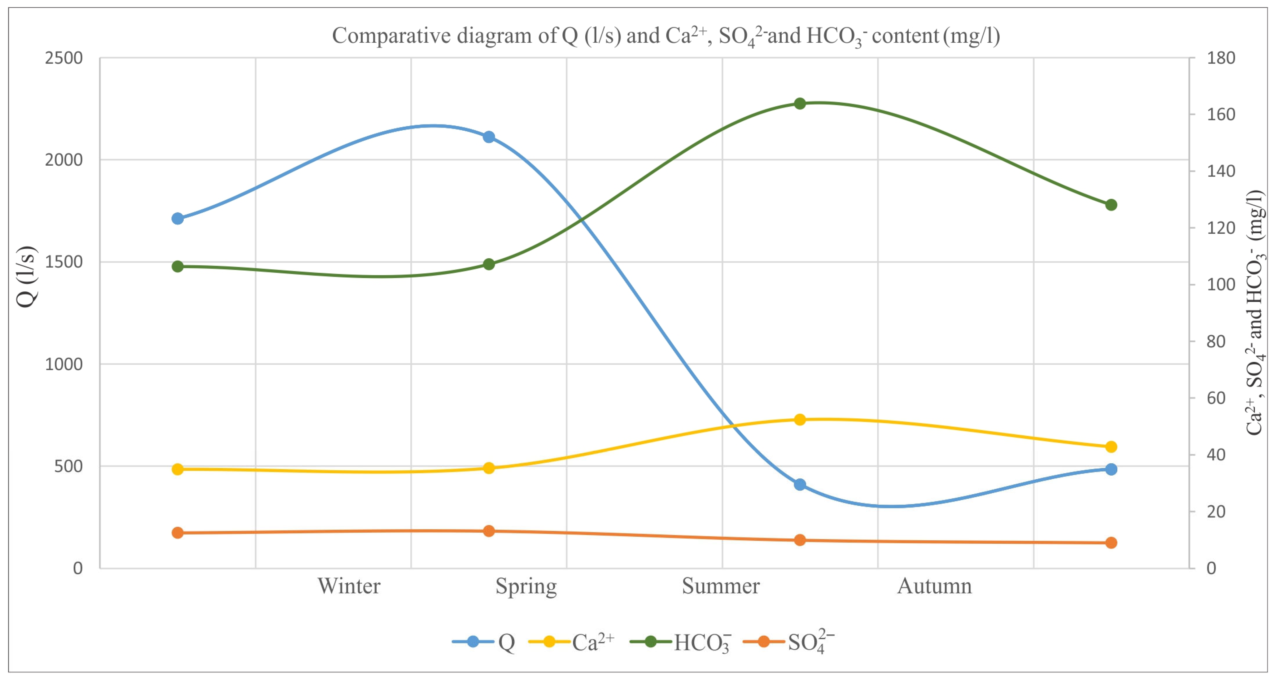
The comparative diagram of the Ca
2+, SO
42−, and HCO
3− contents in the water of Krupaja Spring shows that with the higher capacity, the content of sulfate increases minimally, while the values of calcium and hydrocarbons decrease. With higher capacity, water spends less time within the system and does not become significantly enriched with calcium and hydrocarbonates (
Figure 6).
The content of Mg2+ and Na+ in groundwater increases with depth. The maximum Mg2+ value at the Krupaja Spring was 2.875 mg/L, at the borehole 7.205 mg/L, and at the thermal spring 13.96 m/L, while the maximum Na+ value ranges from 2.202 mg/L at Krupaja Spring, over 8.986 mg/L at borehole B-1, up to 19.07 mg/L at the Krupaja thermal spring. The sulfate content also increases from 13.158 mg/L at the Krupaja Spring to a maximum of 24.797 mg/L at the thermal spring. This ionic composition, which changes with depth, clearly indicates the contact of this water with another rock mass not containing carbonates.
4. Conclusions and Discussion
The Krupaja groundwater system has highly developed karstification and pronounced zonation in groundwater circulation, where cold water circulates to a depth of 133 m (max. ~150 m) and has an age of 26.1 years. The system circulates groundwater with temperature of 25 °C at a depth of 400 m, while groundwater of 26 °C comes from depths greater than 700 m. The thermal water aquifer developed within fissured rock where groundwater has a very long and slow circulation, which extends to the base of karstification, while the circulation at the Krupaja Spring occurs throughout large channels, which can conduct water at a capacity of over 30 m3/s.
The formation conditions for subthermal and thermal karst groundwaters within the Beljanica Massif, as part of the Kučaj-Beljanica Massif, were created through a very long period of karstification of deep karst systems, where so-called hydrogeological–geological barriers played the greatest role. Due to the impossibility of discharging water from the system as a result of to the Red Permian sandstone overthrust on the western rim and the formation of Neogene basins on the northern and southern rim of the massif, the water percolates deeper underground through a system of small cracks and channels, where it changes temperature and hydrogeochemical characteristics as it comes into contact with different rocks, and along local and regional ruptures and/or Red Permian sandstone overthrust, where it drains on the surface of the terrain in the form of subthermal or thermal waters. In addition to the Krupaja System, the most complex system within the Kučaj-Beljanica massif, elsewhere, there are several, more complex systems with deep siphonal circulation of groundwater of subthermal and thermal character, among which the Suvi Do and Krepoljinska Banjica System, the Sisevac System, and the Krivi Vir System stand out [
12,
21], as well as the Mlava-Belosavac-Belosavac 2 System, located on the northern edge of the Beljanica Massif [
12,
21].
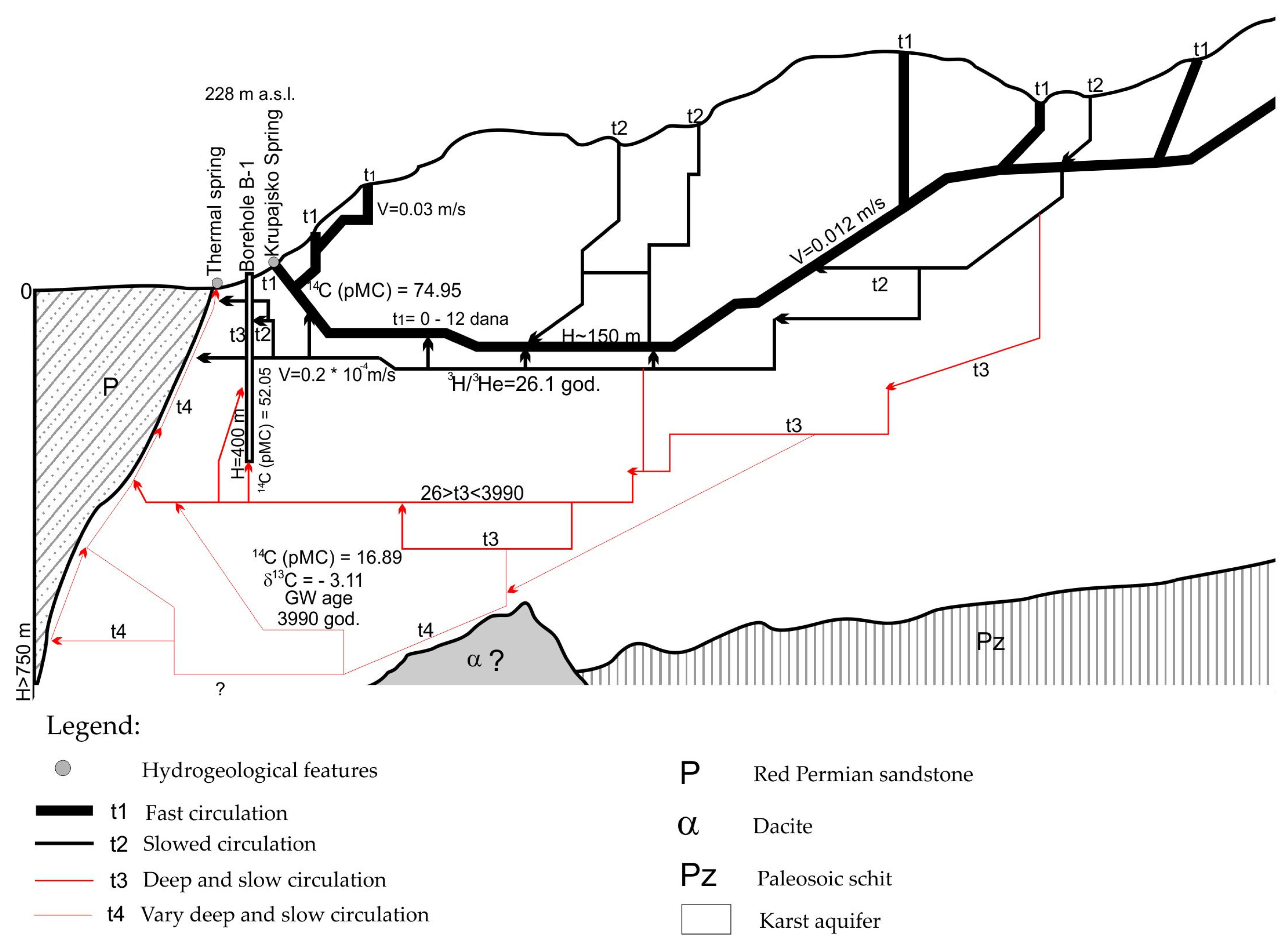
Finally, based on to the obtained data and performed analyses, as well as taking into account previously collected data on groundwater circulation within the Beljanica Massif, a schematic overview of groundwater genesis and circulation of a complex karst system, i.e., the Krupaja system, is presented in
Figure 7. As shown in this schematic profile, this is a system of the Beljanica Massif in which four types of circulation can clearly be differentiated. The first type belongs to fast circulation (channels t1), whose waters fully reflect an active karst system that reacts very quickly to precipitation, i.e., to surface recharge, both in the immediate vicinity of the discharge zone and in the remote zones of this system. So, based on the collected and processed data, it can be concluded that the system reacts to heavy precipitation in less than one day (example from 2014, when a flood wave appeared within 16 h) and over periods of up to 12 days, which is generally the average velocity for flow through the main conduits of the Beljanica Massif.
The main channels, their main recharge zones, and the deep circulation channels (channels t1) are shown in
Figure 7. The second type of circulation takes place through channels and cracks of much smaller dimensions (channels t2), which often require a much longer period of time to “intrude” into the main conductors. In the case of these conductors, it is also assumed that they lie deeper than the main channels of the Krupaja Spring (130 m) which have been explored so far, and subsequently connect with the main channels and ascend to the surface, which is supported by the groundwater age determined by the above-mentioned surveys of these waters. The channels of the t3 group are located much deeper than the cold water circulation zone and can be considered as a transition zone, that is, a mixing zone with the oldest waters of the system. These channels were explored with borehole B-1, allowing us to establish that there is an influx of thermal water (at 25 °C) from the deeper parts of the system, and that there is also an influence, i.e., contact with “young” waters from the cold part of the system, at depths greater than 200 m. Based on this, it is assumed that the channels of group t3 developed to depths of 400–500 m. The deepest circulation of this system, with the oldest (3990 years) groundwater, as confirmed by
14C isotope analysis, occurs within karst conduits t4 (
Figure 7). The schematic profile (
Figure 7) shows the assumed circulation system, as well as the heating and discharge of cold, subthermal, and thermal waters along the Red Permian Sandstone overthrust.
Based on the obtained data, it can be assumed that with a newly drilled 600 m borehole, groundwater with temperatures greater than 35 °C could be extracted. Without new drilling, the thermal water at a temperature of 26 °C in Krupaja can be additionally heated with the use of a heat pump, i.e., by using 33.52 kWh of electrical power, the groundwater temperature could be raised to 30 °C, and with 75.42 kWh of electrical power, the temperature could be raised to 35 °C, which is ideal for sports and recreation tourism. However, the problem is the spring’s low capacity, which would require the introduction of additional quantities of groundwater.


