Article

An AHP-TOWS Analysis of Options for Promoting Disaster Risk Reduction Infrastructure in Informal Settlements of Greater Giyani Local Municipality, South Africa

1
Department of Urban and Regional Planning, Faculty of Science, Engineering and Agriculture, University of Venda, Private Bag X5050, Thohoyandou 0950, South Africa
2
Department of Urban and Regional Planning, Faculty of Natural Sciences and Agriculture, School of Geo and Spatial Sciences, Potchefstroom Campus, Northwest University, Private Bag X6001, Potchefstroom 2531, South Africa
*
Author to whom correspondence should be addressed.
Sustainability 2023, 15(1), 267; https://doi.org/10.3390/su15010267
Submission received: 15 October 2022 / Revised: 13 December 2022 / Accepted: 18 December 2022 / Published: 23 December 2022
(This article belongs to the Section Sustainable Urban and Rural Development)

Abstract

:
In the face of unstoppable urbanisation, disaster risks are projected to increase, mainly in unplanned areas that usually lack disaster risk reducing infrastructure. In Africa, including South Africa, limited resources and capacity hinder the provision of such infrastructure. The objective of this study was to determine options for promoting disaster risk reducing infrastructure in informal settlements in Giyani Municipality, Limpopo Province, South Africa, a disaster risk-prone area. A case study was conducted to collect primary data from purposively selected experts and the SWOT factors from the Integrated Development Plan Report of 2019/2020. A TOWS analytical hierarchical process was applied to pairwise comparisons of factors to prioritize them using eigenvalues and generate strategic options for promoting disaster risk reduction infrastructure in the informal settlements of Giyani Local Municipality. In the TOWS results, the experts suggested integrating traditional authorities into the municipal development processes, implementing an environmental framework that includes disaster management policies and an integrated waste management plan, and developing innovative technological projects that provide up-to-date spatial planning data to provide disaster risk reducing infrastructure in informal areas. This study concludes that the provision of affordable housing, clean regular piped water, storm and sewer drainage systems, street lighting, accessible routes, solid waste collection, electricity, and healthcare services would reduce a range of disaster risks.

1. Introduction

Globally, the issue of sustainable development has become more urgent in the face of unstoppable urbanization as disaster risks are projected to increase, particularly in informal settlements, since these areas are usually unplanned and have no basic infrastructure to lessen their vulnerability to health, fire, and water disaster risks [1,2]. In Africa, including South Africa, limited capacity and resources have constrained the provision of such infrastructure [1]. The lack of disaster risk reduction infrastructure in the informal settlements of South Africa, including Giyani Local Municipality, has increased the vulnerability of informal settlement communities to disaster risks, and this affects the achievement of SDG 11 set out in Agenda 2030. According to McEntire, Crocker, and Peters [3], the provision of infrastructure plays a crucial role in reducing the vulnerability of informal communities to disaster risks which, in turn, promotes the initiative of SDG 11 to make cities and human settlements inclusive, safe, resilient, and sustainable [4]. Furthermore, investing in and maintaining critical infrastructure that reduces risks is essential in making communities resilient to disaster risks [5]. In South Africa, efforts to provide disaster risk reduction infrastructure in informal settlements may be seen in the Spatial Planning and Land Use Management Act of 2013 (Act 16 of 2013), chapter 4 (A), Section 12 (h). The Act requires Local Municipalities to develop Spatial Planning Development Frameworks, which include and integrate informal settlements into the spatial, economic, social, and environmental objectives of development [6].
Disaster risk reduction infrastructure, also known as critical infrastructure, entails a range of engineered systems, assets, and facilities essential for day-to-day societal functions and continued economic and societal functioning [3]. In other words, it involves the provision of the primary physical structures, technical facilities, and systems which are socially, economically, or operationally essential to the functioning of informal settlements, both in normal circumstances and in extreme cases of emergency [3].
The provision of disaster risk reduction infrastructure in the context of Giyani Local Municipality would support essential services in the four informal settlements, Matshamahikani, Dumpsite, Hluephekani, and Ma-Two-Rooms. This kind of infrastructure could be housing, roads for connectivity, regular safe drinkable water, waste management, storm drains, sewerage systems, street lighting, electricity, communications systems, hospitals and clinics, and centers for fire, police, and public administration services [7]. However, the municipality has not been able to provide such infrastructure and services to communities in the four informal settlements, probably due to inadequate strategic planning and development amidst insufficient resources and capacity.
Informal settlements, according to the Housing Development Agency, are unplanned settlements on land that has not been surveyed or proclaimed as residential, and they mainly consist of informal dwellings in the form of shacks [8]. They could also be informal dwellings or makeshift structures not erected according to approved architectural plans [8]. With such settlements established without planning standards, it is not surprising that they remain exposed to disaster risks. The Sendai Framework posits that whether in planned or unplanned areas, it is crucial from the start to build better structures with proper design, construction, and standardization of materials to withstand hazards [9]. A study by Pereira, Shackleton, and Donkor [10] in South Africa reveals that when infrastructural systems such as access roads and storm water drains are not maintained or are insufficient in various municipalities, it increases disaster risks [10]. In order to reduce disaster risks through the provision of disaster risk reducing infrastructure in most South African local municipalities, such as Giyani, there is a need for the municipalities to introduce and re-think innovative ways of addressing municipal challenges amidst limited capacity and resources [1,11].
This study, therefore, aimed to determine options for promoting disaster risk reducing infrastructure in informal settlements in Giyani Municipality, Limpopo Province, South Africa, which is a disaster risk-prone area [12]. Firstly, the study focused on describing the condition of existing disaster risk reduction infrastructure. Secondly, we identified the strengths, weaknesses, threats, and opportunities of Greater Giyani Local Municipality. Thirdly, we formulated combined strategies using the TOWS matrix and applied the AHP method to prioritize strategies and determine the most appropriate.
The TOWS-AHP analysis, which was developed by Saaty [13] and has been followed by different scholars such as Wickramasinghe and Takano [14], Omid [15], and others, is an ideal tool to determine optimum decisions by comparing and selecting strategies in many decision-making processes. It is a pairwise comparison method that prioritizes factors using a nine-point importance scale given by Saaty [13]. However, the application of the TOWS-AHP analysis to disaster risk reduction is still limited. Fundamentally, it helps to derive ratio scales from paired comparisons [16]. Savari and Amghani [17] used a SWO-FAHP-TOWS analysis to develop adaptation strategies among small scale farmers in drought conditions in Iran. Based on their analysis, possible approaches were provided to reduce the severity of drought. Gago et al. [18] used a SWOT-AHP-TOWS analysis to assess stakeholders perceptions of the New Digital Energy Management Platform in the municipality of Loule, southern Portugal. Their findings reveal that the most suitable strategies were those that used the strengths of the system and strategies that took advantage of opportunities while dealing with weaknesses.
This tool was employed in this study to find systematic relationships between strengths, weaknesses, opportunities, and threats. It offered a structure for generating strategies based on these relationships [19]. The method considered experts’ and officials’ opinions and individual preferences [19]. Subsequently, the TOWS matrix formulation was crucial in finding the ideal strategy for determining options for promoting disaster risk reducing infrastructure in informal settlements in Greater Giyani Local Municipality, Limpopo Province, South Africa. Therefore, this paper guides policymakers by determining options for promoting disaster risk reducing infrastructure in informal settlements.
Spatially, the study was carried out in Greater Giyani Municipality, one of the five (5) local municipalities in Mopani District in Limpopo Province, South Africa [20]. Mopani District is one of the regions prone to disaster risks [12]. The scope of the research was restricted to four informal settlements in the municipal area of Greater Giyani Local Municipality, covering approximately 2967.27 square kilometers and holding an estimated population of 256,300 people in 70,537 households [20]. Greater Giyani Municipality is located +/−185 km from Polokwane, +/−100 km from Thohoyandou, and +/−550 km from Tshwane [20]. The town of Giyani is the largest center of population concentration, employment opportunities, shopping, and recreational facilities. These appear to be the driving factors behind the emergence of informal settlements such as Matshamahikani, Dumpsite, Hluephekani, and Ma-Two-Rooms in the municipality.
Following this introduction, this paper briefly examines the methods deployed in this study. This paper goes on to present the condition of existing disaster risk infrastructure and the TOWS analysis results and concludes with recommendations, highlighting possible options for promoting disaster risk reducing infrastructure in informal settlements in Giyani Local Municipality, Limpopo Province, South Africa

2. Materials and Methods

2.1. The Assemblage of Data Used in This Study

A mixed approach, both qualitative and quantitative, was employed in this study [21]. A case study of Giyani Local Municipality that included the collection of SWOT factors from the Integrated Development Plan Report for 2019/2020 [20] (p. 103), as shown in Table A1 Appendix A, and primary data using a pairwise questionnaire and unstructured interviews from 30 purposively selected experts, as shown in Table 1, was carried out. This sample size was considered for the purpose of pairwise comparisons, for which, according to Sekaran and Bougie [22], matched pairs are necessary.
The analytical hierarchical process approach was applied to pairwise comparisons of factors to prioritize them using eigenvalues.

2.2. Conducting the SWOT Analysis

The SWOT analysis, as shown in Table A1, was performed after a field visit to Giyani Local Municipality and a literature review of the Integrated Development Plan Report for 2019/2020 [20], which aided in the identification of the strengths, weaknesses, opportunities, and threats of Giyani Local Municipality in relation to the provision of disaster risk reduction infrastructure [23]. Strengths entail internal factors that give Giyani Municipality an advantage in providing disaster risk reducing infrastructure [24]. Weaknesses are internal negative factors that may hinder the municipality in delivering disaster risk reduction infrastructure in informal settlements [24]. Opportunities involve external factors that the municipality could exploit to its advantage [24]. In addition, threats are external factors that represent limitations that could cause difficulties in the provision of disaster risk reduction infrastructure in informal settlements in Giyani [25].

2.3. Development of a TOWS Matrix

In order to develop combined strategies for promoting disaster risk reduction infrastructure in the informal settlements of Greater Giyani Local Municipality, a TOWS Matrix was derived from the SWOT Analysis model, as shown in Figure 1. It is noteworthy that the acronym TOWS is a modification of SWOT and was advanced by the American International Business Professor Heinz Weirich [26]. The TOWS Matrix is aimed at developing strategic options from an external–internal analysis and is a practical tool that is used to identify solutions for promoting disaster risk reduction infrastructure in informal settlements.
From Figure 1, four TOWS matrix categories were generated to ascertain strategies for promoting disaster risk reduction infrastructure in informal settlements. Category (I) involved SO (strengths–opportunities) as a maxi–maxi strategy in which strengths are used to maximize opportunities. Category (II) constituted WO (weaknesses–opportunities) as a mini–maxi strategy in which weaknesses are minimized by taking advantage of opportunities. Category (III) involved ST (strengths–threats) as a maxi–mini strategy in which strengths are used to minimize threats. Category (IV) involved WT (weaknesses–threats) as a mini–mini strategy in which weaknesses and threats are avoided. Under each strategy group, several sub-strategies were formed. For the SO strategy group, the SO1, SO2, and SO3 sub-groups were formed, for the WO strategy group, the WO1, WO2, and WO3 sub-groups were formed, for the ST strategy group, the ST1, ST2, and ST3 sub-groups were formed, and for the WT strategy group, the WT1, WT2, WT3, and WT4 sub-groups were formed.
Table A1 shows the strengths, weaknesses, opportunities, and threats (SWOT) of Giyani Local Municipality. The strategies formed for promoting disaster risk reduction infrastructure are also presented. The first strategy group, SO, included SO1, SO2, and SO3. The second strategy group, WO, included WO1, WO2, and WO3. The third strategy group, ST, included ST1, ST2, and ST3. The fourth strategy group, WT, included WT1, WT2, WT3, and WT4.

2.4. Optimal Strategies Using the AHP Method

The AHP method is a pairwise comparison method that prioritizes factors using a nine-point importance scale given by Saaty [13]. Essentially, the AHP method was used to derive ratio scales from paired comparisons in this study. The AHP method is a multi-criteria decision-making technique enabling us to reach a general decision on the options for promoting disaster risk reduction infrastructure in the informal settlements of Giyani Local Municipality [16]. In the AHP method, pairwise comparisons are performs to derive the relative importance of the variable in each level of the hierarchy and/or appraises the alternatives in the lowest level of the hierarchy in order to obtain the best decision among alternatives [19]. Given the nature of the responses derived through interviews, the AHP method, which is an especially effective decision-making method when subjectivity exists, was applied to identify the best strategy for promoting disaster risk reduction infrastructure in informal settlements [27].
The prioritization mechanism involved assigning a number from a comparison scale developed by Saaty [13] to represent the relative importance of the criteria. Pairwise comparison matrices of internal and external factors provided the means for the calculation of importance.
As indicated in Table 2, the AHP model is made up of three principles, the structure of the model being the first, the comparative judgement of the criteria and/or alternatives being the second, and the synthesis of the priorities being the third. This model (AHP) was used in this study because the literature shows how widely it has been used in solving many decision-making problems [14,16,19,28,29,30].
In this study, the AHP model helped to prioritize the elements of the TOWS matrix by the choices and opinions of the experts. According to Odu [30], to determine the relative importance of the criteria, after the problem has been resolved, the hierarchy is created and the prioritization process starts. In each of the TOWS levels, the criteria are compared pairwise according to their levels of influence and based on the specified criteria in the higher level. In the AHP model, multiple pairwise comparisons are based on a standardized comparison scale of 1–9 [16].
Considering X   = { Xj   |   j   = 1 ,   2 ,   .   .   . ,   n } as a set of criteria [16], the pairwise comparison of “n” criteria can be summarized in an (n x n) evaluation matrix “A” in which every element ij   ( i ,   j   = 1 ,   2 ,   .   .   . ,   n ) is the quotient of weights of the criteria as shown in Equation (1) below:
A = ( a i j ) n x n = [ a 11 a 12 . a 1 n a 21 a 22 . a 2 n . . . a 1 n a n 2 . a n n ]  
The last step involves each matrix being normalized and finding the relative weights that are given by the right eigenvector (w) corresponding to the largest eigenvalue (λ max), expressed as:
A w = λ   m a x · W
When the pairwise comparisons are completely consistent, matrix A has a rank of 1 and λ   m a x = n. In this case, weights can be obtained by normalizing any of the rows or columns of A [14]. The quality of the output of the AHP model is linked to the consistency of the pairwise comparison judgements [14]. The consistency is defined by the relationship between the entries of A :   a i j × a j k = a i k . The consistency index can be calculated using the formula below:
C I =   λ   m a x 1 n 1
The consistency ratio (CR) is then calculated to determine whether the evaluations are sufficiently consistent. This was achieved by using the formula below:
CR = CI RI
where CI is the consistency index and RI is the random index as set by Saaty [13]. The acceptable upper limit for CR is 0.1. If the final consistency ratio is > 0.1, the evaluation procedure has to be repeated to improve consistency. A CR ratio < 0.1, according to Datta [19] indicates that the experts selected in the study are experienced and knowledgeable in the area being evaluated and that their judgements are consistent.

3. Results and Discussion

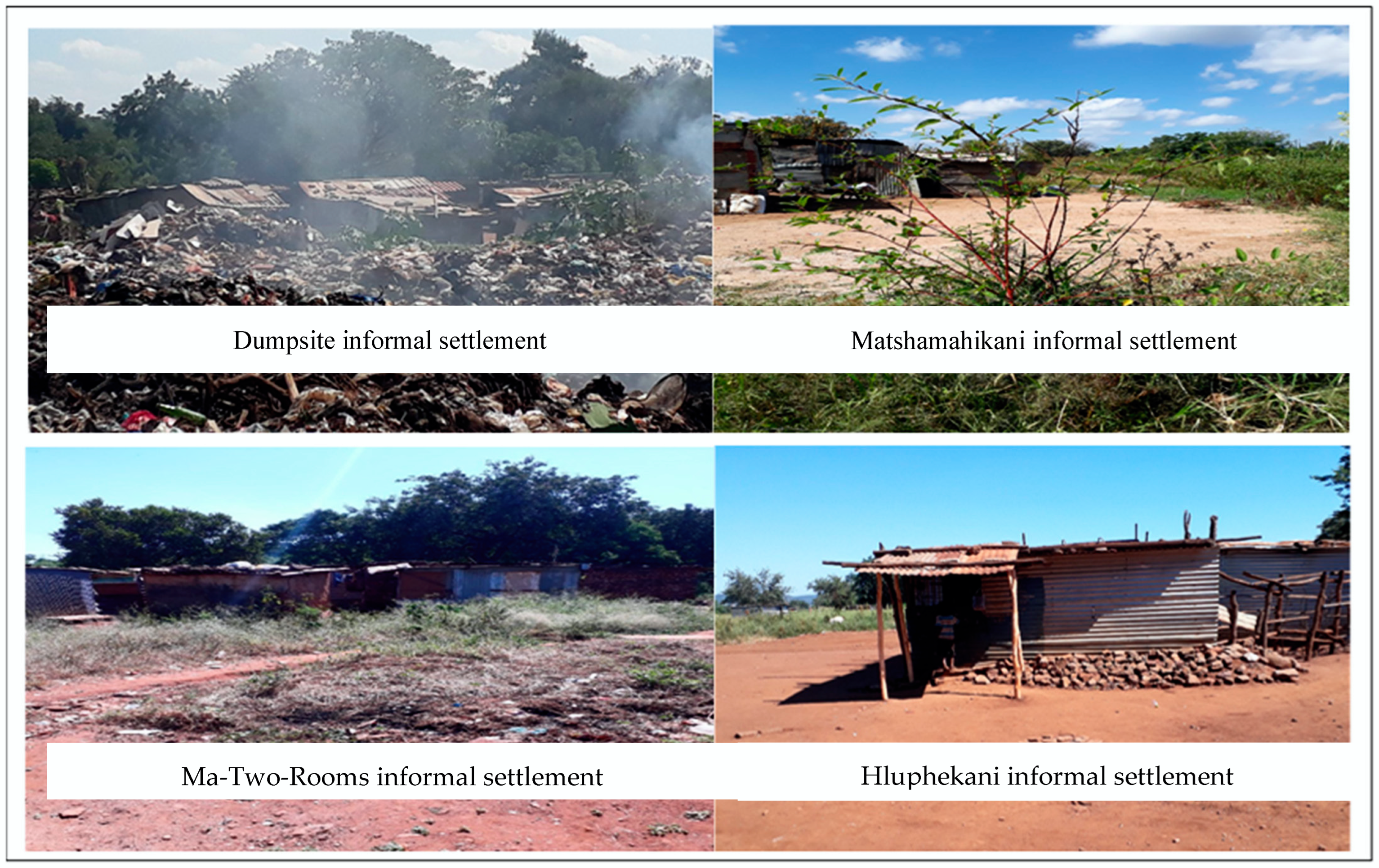
3.1. The Condition of Existing Disaster Risk Reduction Infrastructure in Informal Settlements

As is shown in Figure 2, it is very clear that there is no disaster risk reduction infrastructure in the informal settlements of Ma-Two-Rooms, Dumpsite, Matshamahikani, and Hluphekani. Their current state exposes these informal settlements to water, health, and fire-related disaster risks. This is further exacerbated by their location, as they have been established in environmentally sensitive areas. For example, Ma-Two-Rooms is located next to a reserve and in a relatively hilly area [20]. As a result, the neighborhood experiences water-related risks whereby surface water runoff damages untarred roads, making them unsafe and inaccessible. Furthermore, fire disaster risks in informal settlements are caused by the crowded and illegal housing structures established with cheap and combustible construction materials.
The informal settlement of Hluphekani is located in a low-lying area, and this makes it vulnerable to water-related risks. This is a result of poor drainage and a lack of storm drainage channels to contain water during the rainy seasons.
The informal settlement of Dumpsite is highly vulnerable to health disaster risks because it is located next to a dumpsite. According to Gbenga [31], communities that live around dumpsites are usually exposed to health risks as a result of stagnant water, foul smells, liquid waste, and poor hygiene and sanitation that may lead to respiratory diseases, irritation of the skin, nose and eye problems, gastrointestinal complications, psychological disorders, and allergies. Similarly, a community survey of residents living near an open dumpsite of solid waste in Sabak, Kelantan, Malaysia provided evidence that exposure to dumpsites is hazardous to the health of residents [32].
The informal settlement of Matshamahikani is in an environmentally sensitive area, and it floods during the rainy season. The settlement lacks basic services such as electricity and piped water. Pit latrines are mainly used in these informal settlements, as there are no sewerage and drainage systems.
In addition, the informal settlement of Matshamahikani is located next to the Mrohgolo River, which feeds into a low-lying area designated as a wetland. This land is next to the structures expected to be formalized once the land use scheme that is under review comes into operation. The proximate settlements have not undergone the process of township establishment and are under the custodianship of the traditional authority. All these conditions expose residents to disaster risks.

3.2. TOWS Matrix

The TOWS analysis of the factors in Table A1 generated four different types of combined strategies, as shown in Table 3, Table 4, Table 5 and Table 6.

3.3. Overall Priority of Each Sub-Strategy in the TOWS Matrix Determined by AHP Analysis for Giyani Local Municipality

A TOWS matrix was used to generate strategic options for promoting disaster risk reduction infrastructure in the informal settlements of Greater Giyani Local Municipality, as shown in Table 7.
In the analysis shown in Table 6, the experts identified the SO strategy group as the most ideal strategy group, giving it the highest score of 44%, followed by the WO, ST, and WT groups with scores of 24.2%, 23.4%, and 8.94%, respectively. The consistency ratios of the strategy groups are appropriate since they are less than 0.1.

3.3.1. Strengths–Opportunities Strategy Analysis (SO)

Under the SO category, Giyani Municipality needs to prioritize sub-strategy “SO2” (0.22), which has the highest overall rating. This strategy entails implementing an environmental framework that includes disaster management policies and an integrated waste management plan. This, in turn, promotes proper solid waste collection and disposal that aims at reducing the disaster risks associated with poor solid waste management in informal settlements. It also attempts to address unemployment among informal settlers, particularly the youth, through the introduction of waste recycling projects [33,34,35]. These income-generating projects would then improve the standard and quality of life of the informal settlers, thereby making them less vulnerable to disaster risks. The effective implementation of disaster management policies is important as they are capable of limiting the creation of slums and ensuring the provision of disaster risk reduction infrastructure such as affordable housing, sewerage, and storm water drainage systems [2].

3.3.2. Weaknesses–Opportunities Strategy Analysis (WO)

The sub-strategies “WO2” and “WO3” under the WO category scored equally highly with a degree of importance value of 0.1037 in each case. The experts highlighted these as the most appropriate strategies to enable the municipality to promote disaster risk reduction infrastructure in its informal settlements. The experts believed that to develop innovative technological projects that provide up-to-date infrastructural data would attract government investments. This is important because during fieldwork, it was found that spatial information was not available in the Geo National Database, and this affects spatial planning and infrastructural development. According to Pinfold [36] and the World Bank Group [37], more current and reliable data are usually useful in planning for informal settlements. Such data include satellite images, topographic maps, base maps, and cadastral maps, and can be obtained through the application of geospatial techniques. These techniques involve the use of a geographic information system (GIS) and a database management system (DMS) [38]. The data obtained provide a basis for planning for disaster risk reduction infrastructure, such as clean and safe regular piped water for homes, storm and sewer drainage systems, street lighting, accessible routes, and electricity.
Equally important is sub-strategy “WO3” (0.1037), which requires the municipality to maintain and insure disaster risk reduction infrastructure because of its proximity to Kruger National Park, to promote tourism, and to prevent land invasion.

3.3.3. Strengths–Threats Strategy Analysis (ST)

Under the ST category, the experts rated the “ST2” and “ST3” sub-strategies with a high overall equal degree of importance value (0.1003). The “ST2” strategy highlights that the municipality needs to maximize the revenue generated from the tourism sector to plan for the available land and provide infrastructure for its informal settlements. On the other hand, under the “ST3” strategy, the municipality needs to implement an environmental framework to maintain green infrastructure and protect the environment against ecological degradation. This finding is in line with the United Nations’ actions to reduce disaster risks in informal settlements by promoting green infrastructure and at the same time protecting ecologically fragile areas [39]. Strategy “ST3” would also reduce legal cases against the municipality due to bad and uninsured infrastructure that can lead to a loss of human life because of disasters and accidents.

3.3.4. Weaknesses–Threats Strategy Analysis (WT)

Under the WT strategy group, the most important sub-strategy that the experts recommended was “WT4” (0.0304). This strategy involves the integration of traditional authority into the development process to promote collaboration between the municipality and traditional leaders in planning and providing disaster risk reduction infrastructure, such as affordable housing, sewer drainage systems, and street lighting in informal settlements. This requires the municipality to establish a good work relationship with the community elders and traditional leaders by involving them in decision-making processes. The literature shows that including all stakeholders in the decision-making process is important for development [40]. In addition, with a priority score of 0.026, the “WT3” sub-strategy requires the municipality to improve infrastructural development by providing up-to-date spatial planning data, as the current outdated data misinforms planners. According to Twigg et al. [41], it is important for municipalities to maintain up-to-date data for planning purposes, and even more so for disaster risk reduction in informal settlements. For example, this has worked in Australia, where up-to-date spatial data have often been useful in planning for vulnerable communities and providing disaster risk reduction infrastructure [42].
Given the projected global increase in disaster risks, this study provides strategic means of lessening disaster risks amidst the limited resources of local municipalities by assessing their internal and external environments. However, the process used in this study is subject to limitations. The analysis primarily considered the general internal and external factors of Giyani Municipality that were obtained from experts and the IDP report of 2019/2020. However, these factors are specific only to Giyani Local Municipality. Nevertheless, other municipalities may use the same approach to generate strategies to provide disaster risk reducing infrastructure based on their environments. Furthermore, this analysis was cumbersome and took longer than expected to complete.

4. Conclusions

It can be concluded that disaster risk reducing infrastructure is non-existent in the four informal settlements, thus exposing these spaces to disaster risks. The study contributes to a more methodical understanding of the internal and external factors of Giyani Municipality affecting the provision of disaster risk reducing infrastructure. The analysis served as a way to obtain the views of experts with experience in planning, management, administration, and provision of infrastructure towards the generation of strategies for providing disaster risk reducing infrastructure. From the analysis, we conclude that for successful strategic planning with limited capacity and resources, the municipality needs to consider the suggested priority strategies to provide infrastructure in the informal settlements. It is vital for the municipality to implement an environmental framework that includes disaster management policies and an integrated waste management plan, to reduce disaster risks through the creation of waste recycling jobs, and to improve informal settlers’ standards of living, protect the environment against ecological degradation, and maintain green infrastructure. In addition, developing innovative technological projects that provide up-to-date infrastructural and spatial planning data would attract government investments in the provision of affordable housing, clean and safe regular piped water, storm and sewer drainage systems, street lighting, accessible routes, solid waste collection, electricity, policing, and healthcare services as these would reduce a range of disaster risks. Moreover, maintaining and insuring disaster risk reduction infrastructure in the area around Kruger National Park would promote tourism and reduce legal cases against Giyani Municipality. Furthermore, it is important to plan for the available land and provide disaster risk reduction infrastructure using revenue generated from tourism. Lastly, the municipality needs to integrate traditional authority into the development process. Other policymakers interested in providing disaster risk reduction infrastructure in informal settlements can also develop local and global strategies through the same approach.

Author Contributions

Conceptualization, J.A. and J.C.; methodology, E.I.; software, J.A.; validation, P.B., E.I. and J.C.; formal analysis, J.A.; investigation, P.B.; resources, J.A.; data curation, J.C.; writing—original draft preparation, J.A.; writing—review and editing, E.I.; visualization, P.B.; supervision, J.C.; project administration, J.C.; funding acquisition, J.A. All authors have read and agreed to the published version of the manuscript.

Funding

The University of Venda under the Capacity Development Grant, grant number 6959, funded this research.

Institutional Review Board Statement

This study was conducted in accordance with the University of Venda ethical guidelines and approved by the Ethics Committee (Project NO SES/20/ERM/10/1111 and date of approval 11 November 2020).

Informed Consent Statement

Informed consent was obtained from all subjects involved in the study.

Data Availability Statement

The data presented in this study are available upon corroborated request from the corresponding author. However, certain data may be found at https://www.greatergiyani.gov.za/Greater-Giyani/documents/idp/FINAL%20IDP%202019%2020.pdf, accessed on 5 February 2021.

Acknowledgments

The authors would like to acknowledge the support of those who directly or indirectly contributed to the success of this study.

Conflicts of Interest

The authors declare no conflict of interest.

Appendix A

Table A1. SWOT and TOWS analysis of the study area, Ta WS analysis of the study area.
A SWOT and TOWS analysisInternal Factors
Strengths (S)Weaknesses (W)
S1—Land use management policies in place (SDF, LUMS, by-laws)
S2—Environmental framework (disaster management policies, integrated waste management plan)
S3—Waste management facilities
S4—Tourism
S5—Sports facilities in rural communities
W1—Lack of implementation of land use management policies and by-laws
W2—Lack of engagement with the review processes of policies (lack of ownership)
W3—Outdated data that misinforms planners
W4—Lack of capacity in land use management
W5—Lack of institutional governance systems
W6—Minimum utilization of facilities and development programs
W7—Lack of insured infrastructure
W8—Lack of integrated processes
W9—Lack of implementation of council resolutions
W10—Poor maintenance of infrastructure
External FactorsOpportunities (O)O1—Tourism
O2—Waste recycling that results in the creation of jobs
O3—A healthy society resulting from the availability of sports facilities
O4—Government investment directed to Giyani
O5—Proximity to Kruger National Park
SO1—Implement land use management policies to provide disaster risk reduction infrastructure and attract tourism and government investment (S1 O1 O4 O5)
SO2—Implement an environmental framework to reduce disaster risks and create jobs by the recycling of waste (S2 O2)
SO3—Government investment and funds from tourism can be channeled to provide disaster risk reduction infrastructural projects to maintain liveable spaces (S4 O4)
WO1—Improve governance systems and implement land use policies while promoting disaster risk reduction infrastructure to promote a safe and healthy society (W1 W2 W4 W5 W6 W7 W8 W9 W10 O3)
WO2—Develop innovative technological projects that provide up-to-date infrastructural data to attract government investments and waste recycling for job creation (W3 O2 O4)
WO3—Maintain and insure disaster risk reduction infrastructure to promote tourism, aided by proximity to Kruger National Park (W10 W7 O5)
Threats (T)T1—Lack of critical/specialized skills to ensure legislative compliance resulting in a negative impact on the development of infrastructure
T2—Legal cases against the municipality due to loss of infrastructure and human lives resulting from the occurrence of disasters and accidents involving uninsured and/or poorly maintained infrastructure
T3—Non-functionality of the disaster management centre
T4—Ecological degradation
T5—Relationship with tribal authority (development not addressing the vision)
T6—Unavailability of land for development
T7—Lack of sewerage and storm drainage infrastructure.
ST1—Sports facilities can be used as places for awareness creation (S5 T3)
ST2—Revenue generated from tourism can be used to plan for the available land and provide disaster risk reduction infrastructure (S4 T6 T7)
ST3—Implementation of an environmental framework to protect the environment against ecological degradation and reduce legal cases (S2 T4 T5 T2)
WT1—Awareness creation for disaster risks and their impacts to protect environmentally sensitive areas (W1 T4)
WT2—Training of more skilled personnel to monitor legislative compliance (W4 T1)
WT3—Improve infrastructural development by providing up-to-date spatial planning data (W3 T2 T7)
WT4—Integrate traditional authority into the development process (W5 W8 T5 T6)

References

  1. Satterthwaite, D.; Sverdlik, A. Assessing Health Risks in Informal Settlements in sub-Saharan African Cities, Breifing No. 10; Urban Africa Risk Knowledge: London, UK, 2018. [Google Scholar]
  2. GGA. Understanding Slums and Informal Settlements; through their own lenses towards making Ghanaian Cities resilient. In Policy Brief; Good Governance Africa: Dzorwulu, Ghana, 2018. [Google Scholar]
  3. McEntire, D.; Crocker, C.G.; Peters, E. Addressing vulnerability through an integrated approach. Int. J. Disaster Resil. Built Environ. 2010, 1, 50–64. [Google Scholar] [CrossRef]
  4. UNDP. 2018 Review of SDGs Implementation: SDG 11—Make Cities and Human Settlements Inclusive, Safe, Resilient and Sustainable; UNDP: New York, NY, USA, 2018. [Google Scholar]
  5. Thomas, V.; Lopez, R. Global Increase in Climate-Related Disasters; Asian Development Bank: Mandaluyong City, Philippines, 2015. [Google Scholar]
  6. Department of Rural Development and Land Reform. Spatial Planning and Land Use Management Act 16 of 2013; Department of Rural Development and Land Reform: Cape Town, South Africa, 2013; pp. 1–72. [Google Scholar]
  7. Cilliers, J.; Victor, H. Considering spatial planning for the South African poor: An argument for “planning with”. Town Reg. Plan. 2018, 72, 29–42. [Google Scholar]
  8. Housing Development Agency (HDA). South Africa: Informal Settlements Status; Housing Development Agency (HDA): Johannesburg, South Africa, 2013. [Google Scholar]
  9. Tozier de la Poterie, A.; Baudoin, M.A. From Yokohama to Sendai: Approaches to Participation in International Disaster Risk Reduction Frameworks. Int. J. Disaster Risk Sci. 2015, 6, 128–139. [Google Scholar] [CrossRef] [Green Version]
  10. Pereira, T.; Shackleton, S.; Donkor, F.K. Integrating Climate Change Adaptation (CCA) and Disaster Risk Reduction (DRR) for greater local level resilience: Lessons from a multi-stakeholder think-tank. Policy Br. 2017, 16, 1–8. [Google Scholar]
  11. Turok, I.; Scheba, A. Informal Rental Housing in the South: Dynamic but Neglected. Environ. Urban. 2020, 32, 109–132. [Google Scholar]
  12. Nembilwi, N.; Chikoore, H.; Kori, E.; Munyai, R.B.; Manyanya, T.C. The occurrence of drought in Mopani district municipality, South Africa: Impacts, vulnerability and adaptation. Climate 2021, 9, 61. [Google Scholar] [CrossRef]
  13. Saaty, T. The Analytic Hierarchy Process: Planning, Priority Setting, Resource AllocationNo Title; McGraw-Hill, Inc.: New York, NY, USA, 1980. [Google Scholar]
  14. Takano, S.; Wickramasinghe, V. Application of Combined SWOT and Analytic Hierarchy Process (AHP) for Tourism Revival Strategic Marketing Planning: A Case of Sri Lanka Tourism. J. East. Asia Soc. Transp. Stud. 2010, 8, 954. [Google Scholar]
  15. Omid, M. Strategic planning and urban development by using the SWOT analysis. The case of Urmia city. Rom. Rev. Reg. Stud. 2014, 10, 47–54. [Google Scholar]
  16. Görener, A.; Toker, K.; Uluçay, K. Application of Combined SWOT and AHP: A Case Study for a Manufacturing Firm. Procedia Soc. Behav. Sci. 2012, 58, 1525–1534. [Google Scholar] [CrossRef] [Green Version]
  17. Savari, M.; Amghani, M.S. SWOT-FAHP-TOWS analysis for adaptation strategies development among small-scale farmers in drought conditions. Int. J. Disaster Risk Reduct. 2022, 67, 02695. [Google Scholar] [CrossRef]
  18. Gago, D.; Mendes, P.; Murta, P.; Cabrita, N.; Teixeira, M.R. Stakeholders’ Perceptions of New Digital Energy Management Platform in Municipality of Loulé, Southern Portugal: A SWOT-AHP Analysis. Sustainability 2022, 14, 1445. [Google Scholar] [CrossRef]
  19. Datta, K. Application of SWOT-TOWS Matrix and Analytical Hierarchy Process (AHP) in the Formulation of Geoconservation and Geotourism Development Strategies for Mama Bhagne Pahar: An Important Geomorphosite in West Bengal, India. Geoheritage 2020, 12, 45. [Google Scholar] [CrossRef]
  20. Greater Giyani Municipality. Greater Giyani Municipality Integrated Development Plan 2019/2020; Greater Giyani Municipality: Giyani, South Africa, 2020. [Google Scholar]
  21. Kothari, C.R.; Garg, G. Research Methodology: Methods and Techniques, 3rd ed.; New Age International Publishers: New Delhi, India, 2014. [Google Scholar]
  22. Sekaran, U.; Bougie, R. Research Methods for Business: A Skill Building Approach, 7th ed.; John Wiley & Sons Ltd.: Chichester, UK, 2016. [Google Scholar]
  23. Emet, G.; Merba, T. SWOT Analysis: A Theoretical Review. J. Int. Soc. Res. 2017, 10, 6–11. [Google Scholar]
  24. Dyson, R.G. Strategic development and SWOT analysis at the University of Warwic. Eur. J. Oper. Res. 2004, 152, 631–640. [Google Scholar] [CrossRef]
  25. Rizzo, A.S.; Kim, J.G. A SWOT Analysis of the Field of Virtual Reality Rehabilitation and Therapy. Presence Massachusetts Inst. Technol. 2005, 14, 119–146. [Google Scholar] [CrossRef]
  26. Weihrich, H. The TOWS Matrix—A Tool for Situational Analysis. Long Range Plann. 1982, 15, 54–66. [Google Scholar] [CrossRef]
  27. Nguyen, T.; Ruong, C. Integral SWOT-AHP-TOWS Model for Strategic Agricultural Development in the Context of Drought: A Case study in Ninth Thuan, Vietnam. Int. J. Anal. Hierarchy Process 2022, 14, 1–30. [Google Scholar] [CrossRef]
  28. el Menshawy, A.; Aly, S.S.; Salman, A.M. Sustainable upgrading of informal settlements in the developing world, case study: Ezzbet Abd El Meniem Riyadh, Alexandria, Egypt. Procedia Eng. 2011, 21, 168–177. [Google Scholar] [CrossRef] [Green Version]
  29. Nikolić, D.; Spasić, J.; Živković, Ž.; Djordjević, P.; Mihajlović, I.; Kangas, J. SWOT—AHP model for prioritization of strategies of the resort Stara Planina. Serb. J. Manag. 2015, 10, 141–150. [Google Scholar] [CrossRef] [Green Version]
  30. Odu, G.O. Weighting methods for multi-criteria decision making technique. J. Appl. Sci. Environ. Manag. 2019, 23, 1449. [Google Scholar] [CrossRef] [Green Version]
  31. Gbenga, S. Hazards of Living Near Dumpsites. In The Guardian—Sunday Magazine; The Guardian: London, UK, 2021. [Google Scholar]
  32. Norsa’adah, B.; Salinah, O.; Naing, N.N.; Sarimah, A. Community health survey of residents living near a solid waste open dumpsite in Sabak, Kelantan, Malaysia. Int. J. Environ. Res. Public Health 2020, 17, 311. [Google Scholar] [CrossRef] [PubMed] [Green Version]
  33. Milios, L.; Davani, A.E.; Yu, Y. Sustainability Impact Assessment of Increased Plastic Recycling and Future Pathways of Plastic Waste Management in Sweden. Recycling 2018, 3, 33. [Google Scholar] [CrossRef] [Green Version]
  34. Challcharoenwattana, A.; Pharino, C. Co-Benefits of Household Waste Recycling for Local Community’s Sustainable Waste Management in Thailand. Sustainability 2015, 7, 7417–7437. [Google Scholar] [CrossRef] [Green Version]
  35. Dlamini, B.; Rampedi, I.; Ifegbesan, A. Community Resident’s Opinions and Perceptions on the Effectiveness of Waste Management and Recycling Potential in the Umkhanyakude and Zululand District Municipalities in the KwaZulu-Natal Province of South Africa. Sustainability 2017, 9, 1835. [Google Scholar] [CrossRef] [Green Version]
  36. Pinfold, N. Community Mapping in Informal Settlements for Better Housing and Service Delivery, Cape Town, South Africa; Geospatial Worldforum: Lisbon, Portuguese, 2015. [Google Scholar]
  37. World Bank Group. Building Regulation for Resilience: Managing Risks for Safer Cities; The World Bank: Washington, DC, USA, 2015. [Google Scholar]
  38. Deepak, S.; Rajan, G.; Jairaj, P.G. Geospatial approach for assessment of vulnerability to flood in local self governments. Geoenviron. Disasters 2020, 7, 1–19. [Google Scholar] [CrossRef]
  39. Dodman, D.; Archer, D.; Mayr, M.; Engindeniz, E. Pro-poor climate action in informal settlements. UN-Habitat 2018, 46, 1–60. [Google Scholar]
  40. Skinner, C.; Rampersad, R. A revision of communication strategies for effective disaster risk reduction: A case study of the South Durban basin, KwaZulu-Natal, South Africa. Jamba J. Disaster Risk Stud. 2015, 6, 1–10. [Google Scholar] [CrossRef]
  41. Twigg, J.; Christie, N.; Haworth, J.; Osuteye, E.; Skarlatidou, A. Improved methods for fire risk assessment in low-income and informal settlements. Int. J. Environ. Res. Public Health 2017, 14, 139. [Google Scholar] [CrossRef]
  42. Canberra, P. Planning Safer Communities: Land Use Planning for Natural Hazards; Australian Institute for Disaster Resilience: Melbourne, Australia, 2002. [Google Scholar]
Figure 1. Flow diagram for TOWS matrix applied in this study.
Sustainability 15 00267 g001
Figure 2. Disaster risk reduction infrastructure in the informal settlements of Giyani Municipality.
Sustainability 15 00267 g002
Table 1. Expert profiles.
Number of ExpertsExpert GroupsArea of Expertise
6Municipal officialsMunicipal infrastructure
1Municipal officialsEnvironmental management
2Ward councillorsManagement of informal settlements
1Spatial planningLand use schemes
2Disaster management centre officialsDisaster risk management
3Local economic development and housingHousing and informal settlements
2Traditional leadersResponsible for land matters and traditional affairs
8Informal community eldersResponsible for community leadership
5Police officialsResponsible for maintaining peace and order in informal settlement areas
Table 2. Pairwise comparison scale.
ImportanceExplanation
1Two criteria contribute equally to the objective
3Experience and judgement slightly favor one over another
5Experience and judgement strongly favor one over another
7Criterion is strongly favored, and its dominance is demonstrated in practice
9The importance of one over another affirmed in the highest possible order
2, 4, 6, 8Used to represent a compromise between the priorities listed above
Table 3. Pairwise comparison matrix between sub-strategies in SO group.
GroupSO1SO2SO3Importance Degree
SO11.000.501.000.25
SO22.001.002.000.50
SO31.000.501.000.25
CR = 0.00
Table 4. Pairwise comparison matrix between sub-strategies in WO group.
GroupWO1WO2WO3Importance Degree
WO11.000.501.000.143
WO22.001.002.000.429
WO31.000.501.000.429
CR = 0.00
Table 5. Pairwise comparison matrix between sub-strategies in ST group.
GroupST1ST2ST3Importance Degree
ST11.002.000.500.1429
ST20.501.000.330.4286
ST32.003.001.000.4286
CR = 0.018
Table 6. Pairwise comparison matrix between sub-strategies in WT group.
GroupWT1WT2WT3WT4Importance Degree
WT11.0002.0000.3332.0000.207
WT20.5001.0000.3330.3330.121
WT33.0003.0001.0001.0000.310
WT42.0003.0001.0001.0000.362
CR = 0.022
Table 7. Overall priority of each sub-strategy in the TOWS matrix determined by AHP analysis for Giyani Local Municipality.
Strategy GroupStrategy Group’s PrioritySub-StrategySub-Strategy’s PriorityOverall
Priority
SO
CR = 0.00
0.44SO1—Implement land use management policies to provide disaster risk reduction infrastructure and attract tourism and government investment (S1 O1 O4 O5)0.2500.110
SO2—Implement an environmental framework to reduce disaster risks and create jobs by the recycling of waste (S2 O2)0.5000.220
SO3—Government investment and funds from tourism can be channeled to provide disaster risk reduction infrastructural projects to maintain liveable spaces (S4 O4)0.2500.110
WO
CR = 0.00
0.242WO1—Improve governance systems and implement land use policies while promoting disaster risk reduction infrastructure to promote a safe and healthy society (W1 W2 W4 W5 W6 W7 W8 W9 W10 O3)0.1430.0346
WO2—Develop innovative technological projects that provide up-to-date infrastructural data to attract government investments (W3 O2 O4)0.4290.1037
WO3—Maintain and insure disaster risk reduction infrastructure to promote tourism, aided by proximity to Kruger National Park (W10 W7 O5)0.4290.1037
ST
CR = 0.018
0.234ST1—Sports facilities can be used as places for awareness creation (S5 T3)0.1430.0334
ST2—Revenue generated from tourism can be used to plan for the available land and provide disaster risk reduction infrastructure (S4 T6 T7)0.4290.1003
ST3—Implementation of an environmental framework to protect the environment against ecological degradation and reduce legal cases (S2 T4 T5 T2)0.4290.1003
WT
CR = 0.022
0.084WT1—Awareness creation for disaster risks and their impacts to protect environmentally sensitive areas (W1 T4)0.2070.0174
WT2—Training of more skilled personnel to monitor legislative compliance (W4 T1)0.1210.0101
WT3—Improve infrastructural development by providing up-to-date spatial planning data (W3 T2 T7)0.3100.0261
WT4—Integrate traditional authority into the development process (W5 W8 T5 T6)0.3620.0304
Source: Data based on expert choices and IDP reports (2021).
Disclaimer/Publisher’s Note: The statements, opinions and data contained in all publications are solely those of the individual author(s) and contributor(s) and not of MDPI and/or the editor(s). MDPI and/or the editor(s) disclaim responsibility for any injury to people or property resulting from any ideas, methods, instructions or products referred to in the content.

