Article

Spatial Distribution Characteristics of Traditional Villages and Influence Factors Thereof in Hilly and Gully Areas of Northern Shaanxi

School of Architecture, Xi’an University of Architecture and Technology, Xi’an 710055, China
*
Author to whom correspondence should be addressed.
Sustainability 2022, 14(22), 15327; https://doi.org/10.3390/su142215327
Submission received: 27 September 2022 / Revised: 11 November 2022 / Accepted: 14 November 2022 / Published: 18 November 2022

Abstract

:
In recent traditional village studies, spatial distribution characteristics have gained importance as a basis for rural revitalization and holistic protection; however, the total number of such studies remains small, and these studies do not account for the specific geographical area of China’s Loess Plateau. Contributing to recent efforts, the primary objective of this study was to evaluate the spatial distribution characteristics of the traditional villages in the hilly and gully areas of northern Shaanxi and to link their distribution patterns to the conservation and development of the traditional villages. ArcGIS and GeoDetector software were used to analyze the correlation between the village distribution characteristics and the influencing factors, as well as the differences in the influence of each factor. The research results show the following: (1) The traditional villages in the hilly and gully areas of northern Shaanxi present an uneven agglomeration distribution. The Mizhi, Suide, and Jiaxian areas are the main core agglomeration areas, and Yanchuan is a secondary core agglomeration area. An outward radiation forms with the “dual-core” as a center. (2) The spatial distribution of the traditional villages is positively correlated with slope, average annual temperature, solar radiation, and population density and is negatively correlated with the distance from a river and the GDP per capita; it has a median distribution for elevation, aspect, terrain undulation, and rainfall, and the distribution of the urbanization rate fluctuates. (3) The factor detection results of GeoDetector showed that the socio-economic factors had the strongest influence, followed by the climatic factors. The influence of the geographical factors was weak; the interaction between the influencing factors was enhanced, and the interaction between the population density and the climatic factors was the most obvious. (4) In terms of the influence mechanism, this study supports the claim that “natural environmental factors are the basis for the formation of traditional villages, and socio-economic factors determine the direction of development”. However, it is worth noting that the unique natural and human characteristics of the hilly and gully areas of northern Shaanxi are the fundamental reasons for the differences in the spatial distribution compared to the other regions.

1. Introduction

A village is a common result of a long-term interaction between nature and human beings, which embodies the diverse survival wisdom possessed by rural society and ethnic groups; it reflects an inner connection between human beings and nature and is a representation and witness of agricultural civilization [1]. Traditional villages refer to villages that formed early, possess rich traditional resources [2], and are carriers of living cultural heritage adapted to the local environment [3]. Since the Industrial Revolution, rural areas have generally been affected by industrialization and urbanization; traditional villages have tended to decay or homogenize, and the living cultural heritage of the villages has begun to disappear. In the past 20 years, more than one million villages and a large amount of cultural heritage have disappeared, which means that the protection of traditional villages is extremely urgent [4], and thus, a series of studies and protection measures have been initiated. Since 2012, Chinese government departments have unveiled 6819 national-level schemes designed to protect traditional villages [5]—these protection efforts are an important part of the national “rural revitalization” strategy. How the state can maintain the integrity, authenticity, and continuity of villages and form a benign mutual promotion mechanism between the protection of characteristic resources and the development of villages have become practical problems to be solved urgently [6].
The understanding of the protection and utilization of traditional villages is a deepening process, along with the cultural crisis and environmental degradation that have arisen during the process of urbanization. The research and practice regarding traditional villages have shifted from non-governmental appeals and academic attention to the establishment of government-related protection organizations, and the protection of these villages has become a social issue of widespread concern in China. In the 1990s, the ancient buildings of villages with outstanding cultural value began to be protected, but the “cultural relics restoration” protection method gradually disconnected these villages from their environment [7]. Since 2003, the material and intangible culture of traditional settlements has been protected within the scope of villages. However, due to the large and wide scale of the traditional settlements and the difficulty involved in their protection under the influence of social transformation, these protection works mostly stop at the restoration of the spatial style and ignore cultural heritage, making these efforts difficult to develop and utilize sustainably. Therefore, in 2022, the conservation concept of “concentrated contiguous” was proposed to promote the sustainable development of regional traditional villages (Figure 1). Protecting and developing traditional villages from a regional perspective has become a social consensus and a research direction [8].

2. Literature Review

The study of traditional villages began in the 1840s when German geographer Johann Georg Kohl proposed that topography and landforms have an important impact on traffic and settlement forms. Otto Schluter first proposed the concept of “settlement geography” in 1906. Since then, Paul, Albert, Jean, et al. have further studied the morphology, function and distribution of settlements [9,10,11], broadened the scope of research.
At present, the research on traditional villages has been becoming more and more mature. From the perspective of research content, it mainly falls into the following three aspects. (1) In the context of global environmental change and the re-recognition of traditional ecological wisdom, Erik et al. evaluated the adaptive practices of traditional villages in coping with environmental change and argued that traditional ecological knowledge has the resilience to maintain social ecosystems [12]. Álvaro et al. used the concept of mobile baseline syndrome to measure the resilience of local knowledge systems [13]. Xu et al., from the perspective of the cultural landscape, combined the ecological wisdom of object value and subjective perception to identify traditional villages [14]. Chen et al. investigated 112 traditional villages in the volcanic area of Hainan Province, China, and proposed that ecological adaptability includes not only adaptation to external topography, climate, and resources, but also adaptation to the internal built environment and that village evolution is affected by the social environment [15]. (2) With regard to methods of value evaluation and the protection of the cultural landscape heritage, traditional villages, as “organically evolving landscapes”, are gradually developed in the process of human beings constantly adapting to and responding to the natural and social environment [16]. In the context of urbanization, Yu et al. analyzed the spatial distribution of agricultural cultural landscapes and argued that land use changes will place great pressure on cultural landscapes [17]. Željka et al. combined the relationship between the cultural characteristics and the natural heritage of traditional villages and used cultural models to identify and evaluate landscapes to protect the characteristics and quality of the space [18]. Marta et al. used the concept of biocultural diversity to devise a methodology for assessing biocultural value at the plot level and applied it to three different traditional rural landscapes [19]. (3) With regard to the analysis of the landscape pattern, spatial distribution, and influencing factors of traditional villages, Sprague et al. performed a multi-buffer analysis based on the Japanese rural landscape depicted in historical maps, and the study showed that traditional rural landscapes often have specific spatial structures and that the distance of key landscape features exists only in a limited area [20]. Using ArcGIS software, Yang, Xie, and Qi et al. analyzed the spatial characteristics and influencing factors of tourist villages, and their results showed that tourist villages were clustered in areas with flat terrain, sufficient water sources, and convenient transportation and were close to tourism resources [21,22,23]. The existing research on traditional villages shows the process of spatial morphological characteristics, the protection and utilization of the village ecological culture, and the overall sustainable development of the region. Physical geographical factors are the basis for the formation of traditional villages, and social economy determines the survival of traditional villages [24]. The distribution characteristics of traditional villages reflect the adaptation and development of human beings to the environment.
The research method regarding village spatial distribution involves treating villages as point features, marking them as geographical coordinates on the map, using the ArcGIS spatial analysis function, and analyzing their spatial distribution patterns using the nearest neighbor index, Voronoi diagrams, the index of geographic concentration, the imbalance index, and other methods [25] and then superimposing factors such as topography, hydrology, transportation, society, economy, and culture to analyze the influence mechanism [26]. The geographical detector developed by Wang and Xu is a method to detect the spatial differentiation of geographical elements and to reveal the causes of spatial differentiation [27], and it is widely used in economic, social, ecological, and other fields—such as the evaluation of the importance of each influencing factor in the distribution characteristics of villages and the interaction between multiple factors [28].
Due to the different development trends and mechanisms of geographical phenomena at different spatial scales, the existing research can be divided into administrative regions (national, provincial, and city and county) and geographical units. The distribution of the Chinese traditional villages shows the characteristics of a “core-edge” distribution at the national scale, mostly in the border areas of the province and the areas with low economic level, and it demonstrates the characteristics of the river basins [29,30,31]. As the protection of traditional villages had the characteristics of “top-down”, taking provinces and cities as the research scope was conducive to the implementation of the overall conservation work, and the spatial distribution of provincial and municipal scales was affected by the interaction of the natural environment, regional culture, economy, and other factors [8,32,33]. In addition, traditional villages were formed in the process of long-term adaptation and feedback within a specific geographical range, and so, regional adaptability is a fundamental attribute, and analysis from the perspective of natural geographical units and regional cultural zoning is conducive to the systematic construction of the research genealogy of traditional villages [34,35].
Overall, the current research on the spatial distribution characteristics of traditional villages on the Loess Plateau, especially in the hilly and gully areas of northern Shanxxi, is still lacking. As one of the origins of Chinese civilization, the Loess Plateau has given birth to a unique regional culture of loess, border plugs, and multi-ethnic integration due to its vast and profound loess landscape, frequent wars and turmoil in history, and the frequent rotation of land use methods between agriculture and animal husbandry. The long-term extensive use of land has also made the ecological environment of the area extremely fragile, and the farmers live in relative poverty. Due to the topographic conditions that restrict the development of the settlements, the hilly and gully areas of northern Shaanxi are still dominated by small and medium-sized settlements. Studies have shown that villages are areas which experience the most serious levels of soil erosion on the Loess Plateau [36], and so, the study of traditional villages is of great significance for ecological protection and cultural inheritance for the construction of the local living environment. This study analyzed the influencing factors regarding the spatial distribution of traditional villages in the hilly and gully areas of northern Shaanxi, interpreted the regional ecological wisdom contained therein, and provided theoretical support for the protection and sustainable development of traditional villages (Figure 2).
Based on the above understanding, this study took the hilly and gully areas of northern Shaanxi, which is located in the middle of the Loess Plateau, as an example, focusing on the scientific problem of the “spatial distribution of traditional villages and their influencing factors”; it was studied based on the following three aspects: (1) constructing a research framework for the spatial distribution mechanism of traditional villages; (2) assessing the effect of traditional village contexts on their spatial distribution and whether these factors have a positive or negative impact on spatial distribution; and (3) comparing the differences between influencing factors regarding the driving forces of spatial distribution in traditional villages in order to establish their theoretical and practically supportive role in the sustainable development of traditional villages against the background of rural revitalization.

3. Research Object and Methodology
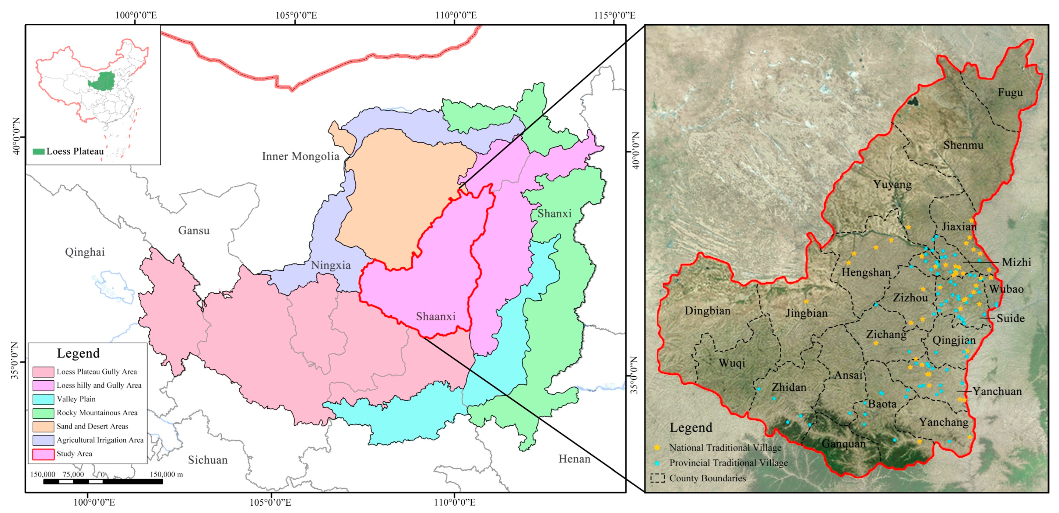
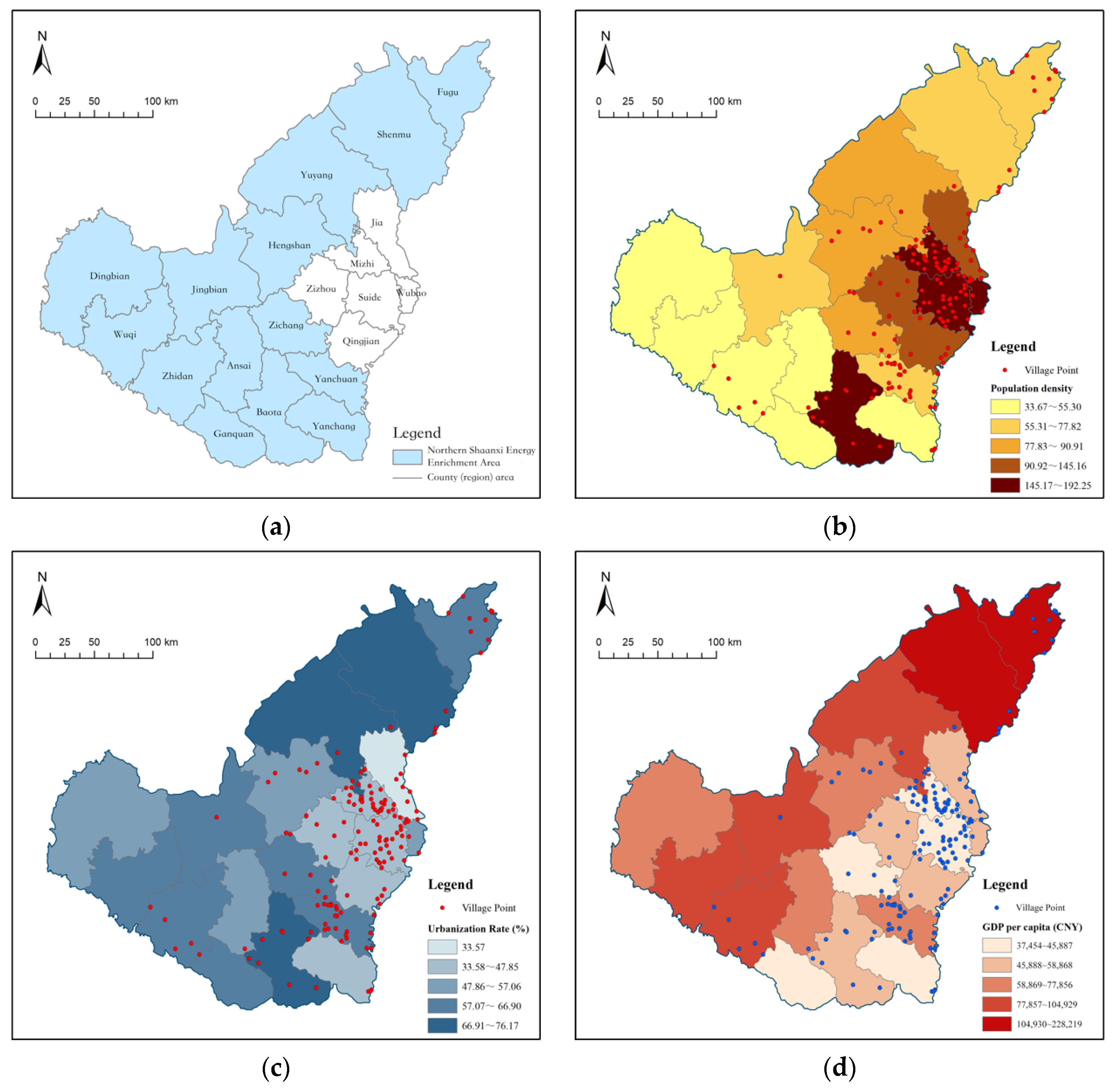
3.1. Study Area

Due to the long-term unsustainable construction of human settlements throughout history, coupled with the fact that soil erosion is a characteristic attribute of the natural substrate of the Loess Plateau, by the 1940s the regional ecological environment was extremely degraded. By the end of the 1940s, efforts including water and soil control and returning farmland to forest began to greatly restore the environment, but the living environment in this region is still relatively degraded and urgently needs to be improved. Studies have shown that against the background of climate change, the Loess Plateau will gradually enter a humid and warm period [37], and the human settlement environment may experience a transformation. The key to this problem lies in how to formulate a plan for human settlement construction, improving farmers’ livelihoods and living standards on the basis of protecting the ecological environment, to achieve the sustainable development of villages. Therefore, this study focuses on the traditional villages in the hilly and gully areas of northern Shaanxi in the middle of the Loess Plateau; these areas have a typical loess topography.
The hilly and gully areas of northern Shaanxi are located in the central region of the Loess Plateau, geographically located in the range of 34° N~39° N, 107° E~111° E [38], with a land area of 66,000 km2, accounting for 32.1% of the total area of Shaanxi Province (Figure 3). The loess here is about 100 m to 200 m thick, and it mainly consists of ridge-shaped and beam-shaped hills, with crisscross ravines and a broken topography. The land area with a slope over 15° accounts for 50%~70% of the area, and the gully density is up to 2 km/km2~7.6 km/km2. Apart from the northern sandstorm area, a mountainous terrain with gullies as a skeleton is formed. As of August 2022, there were 154 traditional villages, including 45 national traditional villages and 154 provincial traditional villages (the provincial traditional villages include the 45 national traditional villages).
In this paper, the list of traditional villages published by the Ministry of Housing and Urban–Rural Development of China and Shaanxi Province in the study area was selected as a research sample. First, the selection of national and provincial traditional villages was based on a total of 20 indicators belonging to 3 aspects: the traditional architecture, site selection and pattern, and intangible cultural heritage of the villages (see Appendix A Table A1). These factors covered both the tangible and the intangible cultural characteristics [39] in order to more completely represent the ecological wisdom generated by human adaptations to the environment and the distribution characteristics of the villages with relatively high conservation values in different geographical environments. Second, because the protection and the development of traditional villages are important parts of China’s “Rural Revitalization” strategy, this research had great practical significance.

3.2. Data Source and Processing

The study data came from the Chinese traditional villages website and the data released by the Shaanxi Provincial Department of Housing and Urban–Rural Development (as of August 2022) [5,40]. Longitude and latitude information for the 154 national and provincial traditional villages in the hilly and gully areas of northern Shaanxi was collected through Google Earth. The study data included terrain DEM data, village-level digital elevation model data, satellite images and field survey photos, and data of the hilly and gully areas of northern Shaanxi.
The geographic coordinate information for the 154 research samples was imported into ArcGIS 10.8 to create a geospatial database of the traditional villages in northern Shaanxi. The elevation data of the hilly and gully areas in northern Shaanxi (GDEMV3 30M resolution digital elevation data) came from a geospatial data cloud (http://www.gscloud.cn/, accessed on 22 August 2022), from which information on the elevation, slope, aspect, terrain relief, river level, and watershed was extracted, along with other information. According to the statistical yearbook and local history, the urbanization rate of villages, population density, per capita GDP, the amount of intangible cultural heritage, etc., were extracted. Combined field research was performed to check the literature information, and all data were corrected to ensure the consistency and validity of the data.

3.3. Research Methodology

With the quantitative system model of the terrain adaptability of traditional villages constructed in this paper, the spatial distribution of the traditional villages was analyzed, and the mechanisms and laws behind their characteristics were explored. Using ArcGIS, GeoDetector, and other analysis and statistical tools, the overall spatial distribution characteristics of the traditional villages were studied using methods such as the nearest neighbor index, Voronoi diagrams, the imbalance index, the index of geographic concentration, and kernel density analysis [25,41]. The ArcGIS data visualization function was used to quantify the quantitative data relationship of the traditional village distribution under the influence of different factors, and the equidistant frequency map was drawn to evaluate the distribution characteristics of the traditional villages in relation to each influencing factor. Finally, GeoDetector was used to perform single-factor detection and interaction detection to explore the influence factor gradient and its interaction mechanism (Table 1).

4. Results

4.1. Geographical Distribution Characteristics of Traditional Villages in Northern Shaanxi

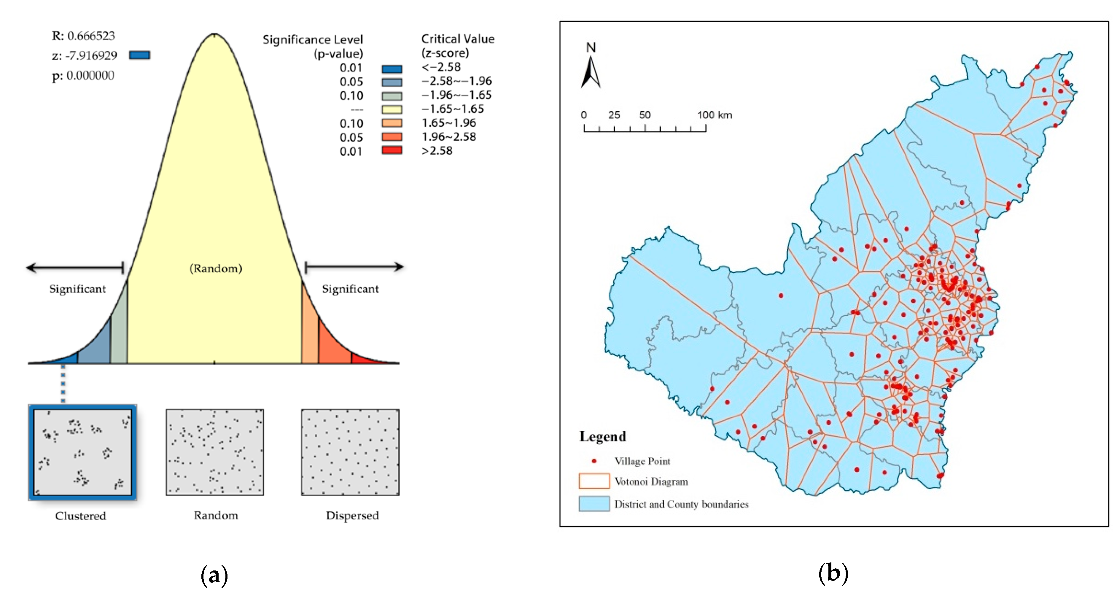
4.1.1. Overall Spatial Distribution Characteristics

The nearest neighbor analysis of the traditional villages in the hilly and gully areas of northern Shaanxi was carried out by using ArcGIS. For the traditional villages in the hilly and gully areas of northern Shaanxi, we observed a theoretical average nearest neighbor distance of r E = 10,402.59 m, an actual average nearest neighbor of r 1 = 6933.57 m, and a nearest neighbor index of R = 0.67, R < 1, Z = −7.92, p = 0.00 (Figure 4a). The results show that the traditional villages in the hilly and gully areas of northern Shaanxi are clustered. In order to make the conclusion more accurate, the Voronoi diagram was constructed by using the Thiessen polygon tool, and a coefficient of variation of the Voronoi diagram for the hilly and gully areas of northern Shaanxi was obtained. The Voronoi polygon for the hilly and gully areas of northern Shaanxi standard has a deviation of 1040.11 km2, an average of 432.86 km2, and a CV = 240.29%, which also indicate that the spatial distribution of the traditional villages in the hilly and gully areas of northern Shaanxi is agglomerative (Figure 4b).

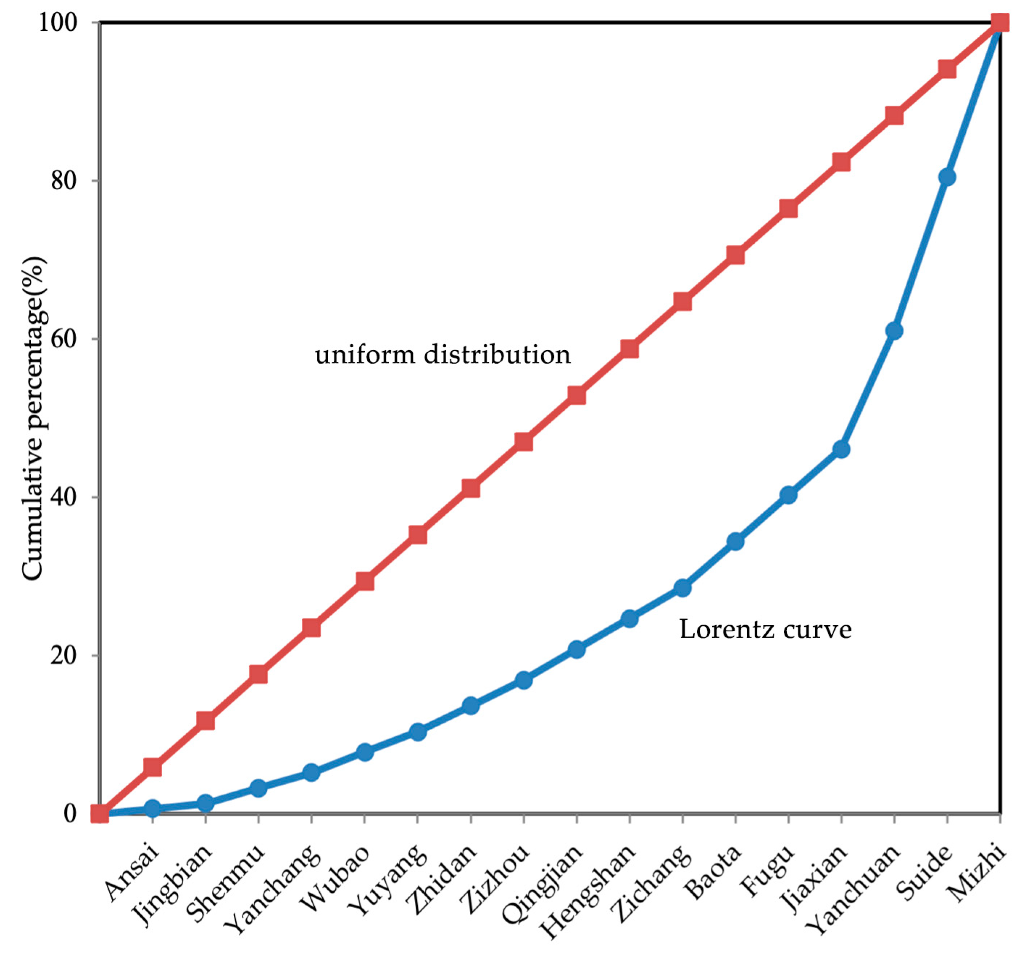
4.1.2. Spatial Distribution Balance

Through the imbalance index method, combined with the distribution quantity information (Table 2) of the traditional villages in the hilly and gully areas of northern Shaanxi, the spatial distribution imbalance index was calculated as S = 0.506, indicating that the distribution of traditional villages in the whole area is uneven. The Lorenz for the traditional villages is generated based on the statistical data (Figure 5). The Lorenz curve is relatively far from the uniform distribution line and has a large curvature, which indicates that the distribution of the counties is uneven. The total number of traditional villages in the Mizhi, Suide, and Yanchuan counties accounts for 53.9% of the total. In addition, there are no traditional villages distributed in Dingbian, Ganquan, and Wuqi.

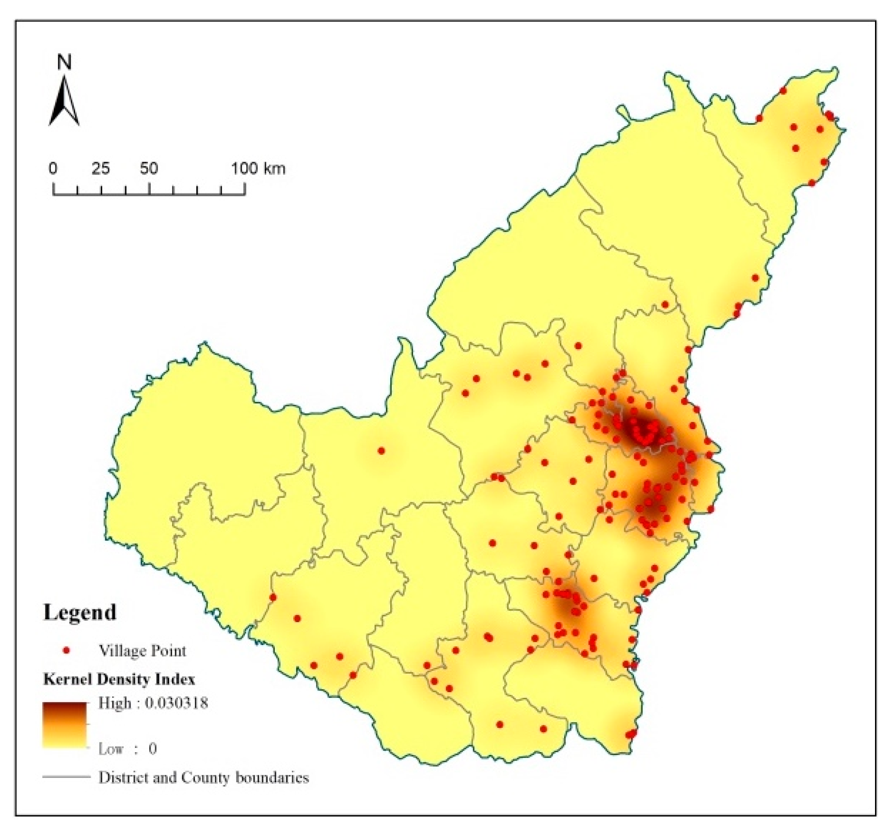
4.1.3. Analysis of Agglomeration Areas in Spatial Distribution

Through the index of the geographic concentration method, the geographic concentration index is calculated as G = 34.250, indicating that the distribution of the traditional villages is relatively concentrated. In order to further reveal the concentration of the distribution, density mapping was carried out in combination with the kernel density analysis method. It was found that the traditional villages were mainly distributed in the eastern part of the studied area, with the areas around Suide, Mizhi, and Jiaxian being the main agglomeration areas, while Yanchuan is a secondary agglomeration area. The villages are less commonly distributed in the west and north and fail to form large-scale agglomerations (Figure 6).

4.2. Influence Factors of Spatial Distribution of Traditional Villages in Northern Shaanxi

4.2.1. Natural Environment Factors

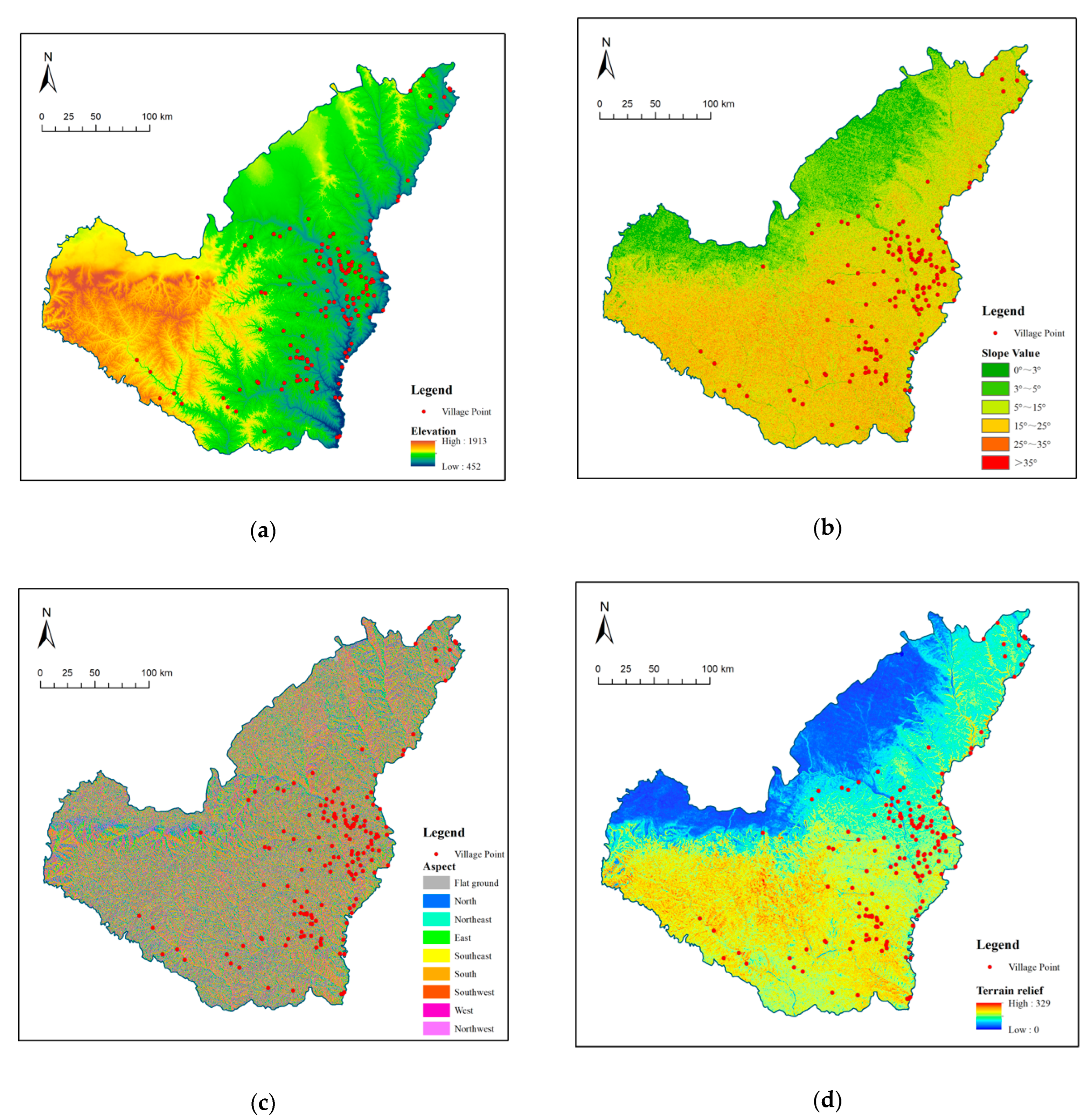
Relationship between Spatial Distribution and Topography of Traditional Villages

The hilly and gully areas in northern Shaanxi are 492 m to 1913 m above sea level, with the terrain rising from east to west and the slope gradually decreasing from southeast to northwest. The elevation of the area adjacent to the Yellow River on the east side is low, and the deep loess layer in the northeast and middle is eroded by the river and forms a typical loess hilly ravine landform [42]. The western areas, such as Dingbian, Jingbian, and Wuqi, have higher terrain in the Baiyu Mountains. In the study area, apart from a windy sand beach in the northwest with a relatively gentle slope, the areas are dominated by hilly terrain with a relatively large slope. This terrain environment of “more mountains and less flat land” has a great impact on the site selection and layout of the villages, resulting in an agglomeration pattern of “occupying slopes without occupying land” [43]. The average elevation, slope, slope aspect, and terrain relief of the traditional villages were calculated through ArcGIS; classification was performed by using a reclassification tool, and the spatial distribution of the topographical factors for the traditional villages was obtained after the statistical analysis.
The analysis results indicate that the traditional villages are mainly distributed in the middle/high altitude areas with an elevation of 700 m to 1200 m, where a total of 137 villages are located, accounting for 88.97% of the total number of traditional villages (Figure 7a). This is related to the fact that the settlements should be close to a river or water source at a lower altitude and close to terraces higher up the mountain to meet the cultivation distance requirements; so, the sites are mostly in the foothills. From the perspective of slope, the traditional villages are mainly distributed in areas with a slope of 10° to 20°, with 146 villages being located in these areas, accounting for 94.80% of the total number of traditional villages (Figure 7b). On the one hand, this is directly related to the geographical conditions of the mountainous landforms; on the other, the complex terrain forms an isolated living environment, blocking cultural exchange with the outside world, which is conducive to the survival of traditional villages. From the perspective of the slope aspect, the traditional villages are located on the slopes facing southeast, south, or southwest, among which 136 villages are located on the slopes facing south, accounting for 88.31% of the total number of traditional villages (Figure 7c). First, due to the fragmentation of the landform, people have the ability to choose to build settlements in a better location; second, because the cave buildings are built by excavating space into the loess mountain, only the door opening is used as an outward opening, and the settlements are forced to be located in the south-facing side of the mountains for lighting and heating needs. From the perspective of terrain relief, there are 108 villages distributed in moderate relief hills, accounting for 70.12% of the total number of traditional villages (Figure 7d). This site selection trend is determined by the fact that the low-undulating areas are greatly affected by urbanization; traditional villages are not easy to preserve, and high-undulating areas cause great obstacles to people’s production and living activities.
The results are basically in line with the characteristics of traditional villages occupying hilly and mountainous terrains [32]. Because the terrain conditions limit communication between local people and the outside world, they are less influenced by modern civilization, and so, traditional villages are easier to preserve [33]. The difference is that, due to the dependence of the cave buildings on the topography and lighting of the loess mountains, there are extremely strict requirements regarding slope for village site selection. In addition, the limited space of the valley plain and the farmland mostly located higher up the mountain also have an impact on the location of traditional villages.

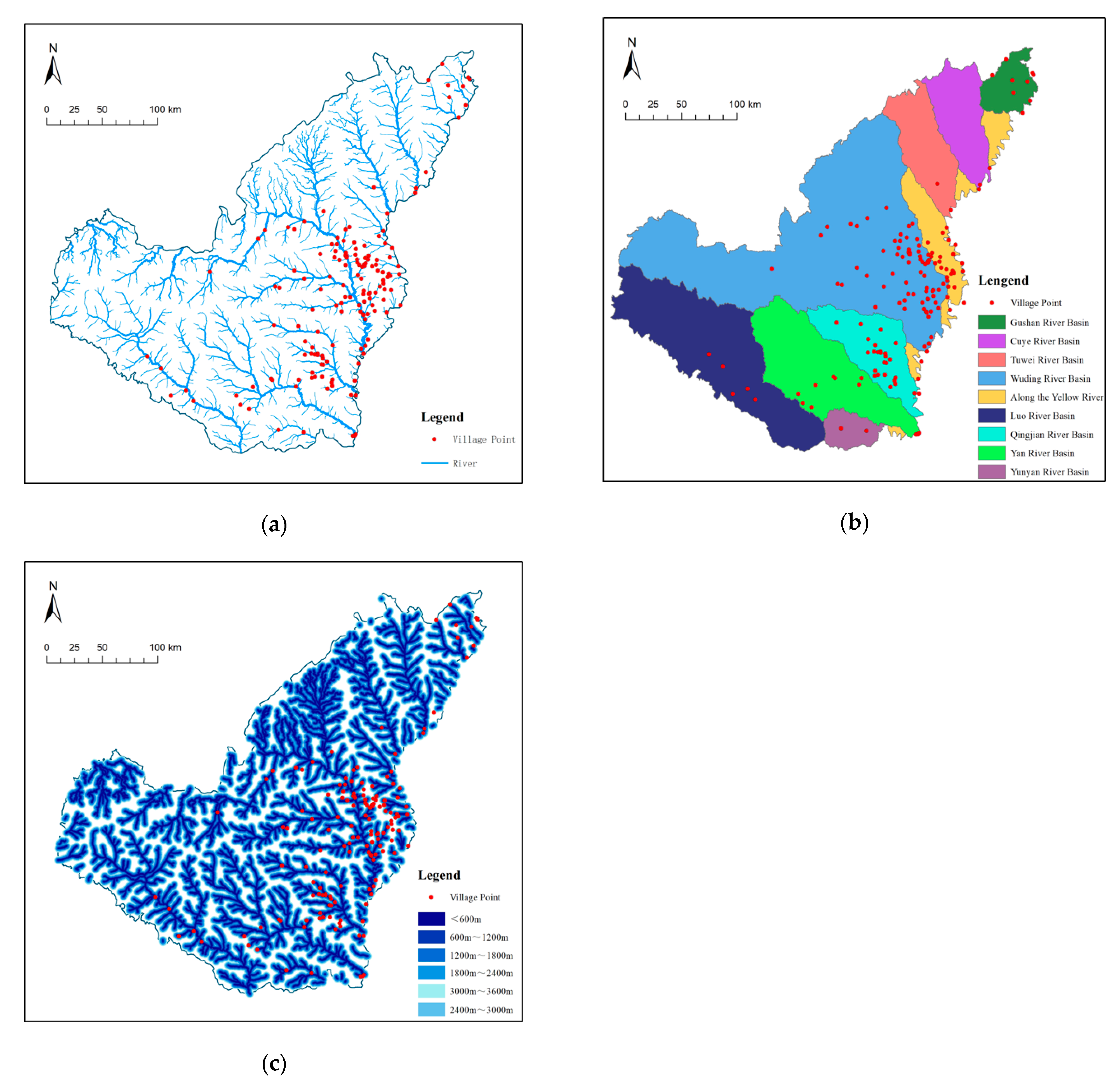
Relationship between Spatial Distribution and River Systems of Traditional Villages

Historically, the dendritic river valley water systems in the hilly and gully areas of northern Shaanxi were formed due to river erosion over a long time period. The Wuding River, the Kuye River, the Tuwei River, the Qingjian River, the Yan River, and other rivers flow into the Yellow River from northwest to southeast. The development of human settlement space presents a strong correlation with these water systems. The areas at the lower confluences of these rivers developed as large towns due to the abundant water resources. For example, Yan’an city is located at a confluence of the Yan River and the North River, Suide county is located at a confluence of the Dali River and the Wuding River, and Jiaxian county is located at a confluence of the Jialu River and the Yellow River. Smaller tributaries in the upper reaches of the rivers are scattered with smaller-scale settlements, which form a spatial pattern in which the settlements and roads are distributed along the water systems. Using the “river classification”, “catchment area”, and “buffer area” tools in ArcGIS, the river classification, watershed division, and river buffer zone are carried out for the river systems in the hilly and gully areas of northern Shaanxi.
The results show that the traditional villages are mostly clustered along rivers in the middle of the main trunk of the river (Figure 8a); this is because traditional villages with outstanding cultural value can only be formed in areas with relatively rich resources, and the northwest is limited by water resources, making it difficult for villages to develop well, and most of the downstream areas of the river have developed into towns. Most of the traditional villages are located in the Wuding River Basin and the Qingjian River Basin (Figure 8b). There are 127 villages in a 600 m river buffer area in the study area, accounting for 82.47% of the total number of villages. The villages are gradually less commonly distributed as the distance from a river increases, indicating that water sources play an important role in the site selection of traditional villages (Figure 8c).
The research results are in line with the watershed distribution characteristics of the traditional villages of “mainstream aggregation and scattered tributaries” [31]. However, unlike other regions, where settlements are located at a certain distance from rivers in order to prevent flooding, the traditional villages in the hilly and gully areas of northern Shaanxi are relatively close to the rivers. The main reason for this is that semi-arid areas are limited by water resources, and the settlements are as close to water sources as possible. In addition, most of the villages are located in the foothills of the medium and high slope zone, where the pressure on the flood control is small.

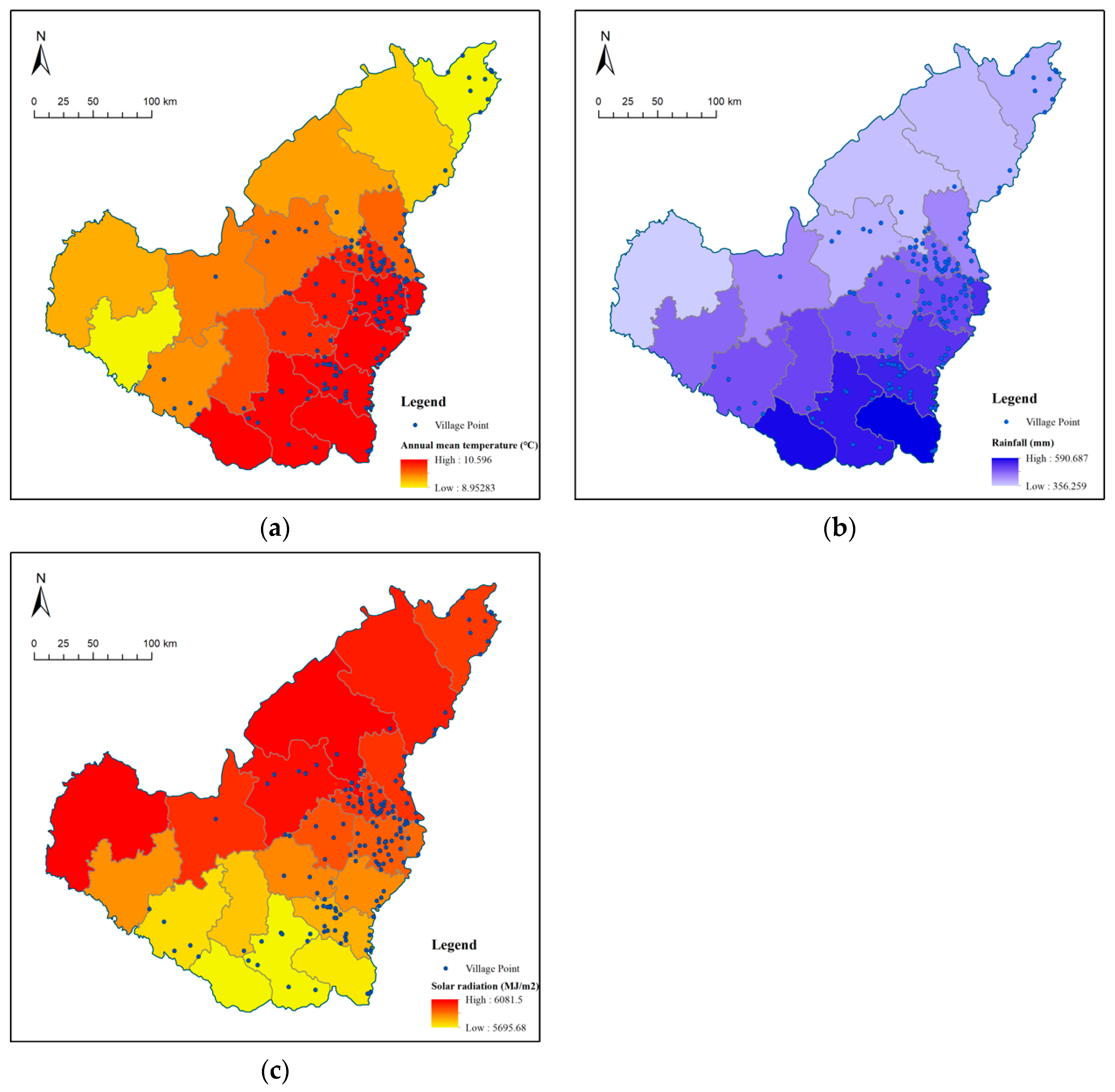
Relationship between Spatial Distribution and Climate Environment of Traditional Villages

In order to build a microclimate suitable for human habitation and to ensure crop production, traditional villages are mostly located in areas with better climatic conditions. Light and precipitation are important factors in site selection. Parameters such as average temperature, rainfall, and solar radiation in the hilly and gully areas of northern Shaanxi in 2021 were selected. ArcGIS was used to process the relevant data of the counties and districts, and the distribution points of the traditional villages were superimposed to extract the information regarding the average annual temperature, rainfall, and solar radiation of the villages.
The traditional villages are mainly distributed in areas with annual average temperatures of 8.9~10.5 °C, with 110 accounting for 71.43% of the total (Figure 9a). There are 97 villages distributed in areas with an average annual rainfall of 450~550 mm, accounting for 62.99% of the total (Figure 9b). There are 101 villages distributed in the area with solar radiation of 5800~6000 MJ/m2, accounting for 65.58% of the total (Figure 9c).
The results of this study are different from those of the related studies because people tend to build settlements in areas with suitable climates. Against the background of different climatic conditions, the spatial distribution of the villages showed great differences. The hilly and gully areas of northern Shaanxi have a continental monsoon climate, and the site selection of traditional villages tends to involve areas with relatively good hydrothermal conditions conducive to agricultural production, and the higher the average annual temperature and the more rainfall, the more the traditional villages are distributed within this area. However, due to the fact that the northwest of the region is affected by wind and sand, which are not conducive to the development of human settlements, the traditional villages are less commonly distributed in the areas with the highest solar radiation.

4.2.2. Social and Human Factors

Relationship between Spatial Distribution and Socioeconomic Situation of Traditional Villages

In the late 1990s, some parts of northern Shaanxi had become among the main producing areas of energy resources in China, creating an economic boom with an average annual economic growth of 20%. The uneven distribution of resources led to uneven regional socio-economic development (Figure 10a). With the huge economic benefits brought about by energy development in energy-rich areas, the rapid increase in per capita income and the deterioration of the ecological environment prompted population migration to the central towns (Yan’an and Xi’an) [44]. Therefore, the population density of Yan’an and the poorer areas centered around Mizhi and Jiaxian is relatively high. By using ArcGIS’s “natural breakpoint classification method”, we visualized the regional statistics for the urbanization rate, population density, and per capita GDP and the statistics for the distribution of the traditional villages.
The spatial distribution of the traditional villages correlated with the socio-economic factors. In areas with a relatively dense population distribution, there are more traditional villages (Figure 10b). In areas with higher urbanization rates and per capita GDP, there are fewer traditional villages (Figure 10c,d).
The research results are in line with the relevant research demonstrating that socio-economic development has a negative impact on the survival of traditional villages [32]. This is related to the tendency of social and economic development toward “advancedness” and the abandonment of the “traditional” [45]. Poverty has slowed down urbanization in these areas and allowed their traditional villages to be preserved. In addition to the high level of development of the regional central cities, the impact of resource distribution on economic development is also an important cause of the spatial distribution of the traditional villages.

Relationship between Spatial Distribution and Historical and Cultural Heritage of Traditional Villages

Historically, the hilly and gully areas in northern Shaanxi have been a battleground for military strategists for a long time. Throughout history, settled farming people and nomadic people, who “live by water and grass”, repeatedly fought a tug-of-war over this land, resulting in repeat changes of land utilization between agriculture and animal husbandry. Military defense, commerce, immigration, and clan and frontier culture formed a multi-integrated culture in the area. The traditional villages have preserved a large amount of this cultural heritage [46], presenting distinct regional characteristics. Such villages include, for example: Zhenjing village, a village of military frontiers formed in the Ming Dynasty; Huyan village, a village of post houses formed due to trade and transportation; Liujiamao village, a village of manors built by ancient landlords; and Nihegou village, a village with farming as a main mode of production (Figure 11). This study used ArcGIS to perform visualized classification of the amount of intangible cultural heritage and the traditional villages in the hilly and gully areas of northern Shaanxi.
As intangible cultural heritage is an important indicator in the selection process of traditional villages, theoretically speaking the distribution of intangible cultural heritage and traditional villages should be positively correlated. However, the distribution of traditional villages in the hilly and gully areas of northern Shaanxi showed different results, mainly in areas with less cultural heritage (Figure 12). It is speculated that because intangible cultural heritage and traditional villages are declared by local government organizations, regional enthusiasm had a non-negligible impact on the selection results.
The spatial distribution of traditional villages is positively correlated with slope, average annual temperature, solar radiation, and population density; it is negatively correlated with distance from a river and GDP per capita; it has a median distribution for elevation, aspect, terrain undulation, and rainfall, and the distribution of the urbanization rate fluctuates (Figure 13).

4.3. Quantification of Influence Factors of Spatial Distribution

This research selected 12 factors in order to further reveal the driving factors of the different spatial distribution characteristics of the traditional villages, including the elevation (X1), slope (X2), slope aspect (X3), terrain relief (X4), distance to the river (X5), solar radiation (X6), average temperature (X7), rainfall (X8), per capita GDP (X9), urbanization rate (X10), population density (X11), and the amount of intangible cultural heritage (X12). By using the GeoDetector factor detection function, the degree of influence of each influence factor on the spatial distribution of the traditional villages in the hilly and gully areas of northern Shaanxi was analyzed. See Appendix A Table A2 for the sample villages’ data.

4.3.1. Single-Factor Detection

As can be seen from the results of the GeoDetector analysis, each factor has a significant influence on the spatial distribution characteristics when p < 0.05 of the traditional villages (Appendix A Table A3). The factors are ranked according to their influence as: GDP per capita > population density > urbanization rate > rainfall > average temperature > solar radiation > amount of intangible cultural heritage > terrain relief > elevation > slope aspect > slope > distance from a river (Figure 14a). The results show that the socio-economic factors had a strong influence on the distribution of the traditional villages, while the natural environmental factors had a weak influence. At present, there are few related studies on the detection of influence factors for traditional village spatial distribution—Gao et al. studied the distribution of traditional Chinese villages according to the alternating influence of natural factors and social factors [29], while Wang et al. concluded that natural environmental factors have the highest explanatory power in the southwest region [47]. The reason why the results of this study are partially different from the existing studies is that the natural and social environment of the Loess Plateau studied in this paper is significantly different from the others. When incomes increase and economic levels rise, most people choose to migrate to neighboring regional central cities to settle, and the abandonment of houses can cause the degradation of villages, which is not conducive to the survival of traditional villages. The correlation analysis between population density and urbanization rate further confirmed this conclusion. Among the natural environmental factors, they are manifested as climatic factors > topographic factors > hydrological factors. This is related to the fractal characteristics of the broken landforms in the hilly and gully areas of northern Shaanxi [48], and people have more choices regarding the geographical environment. In this context, the demand for a suitable climate is significantly greater than the demand for topography and hydrology.

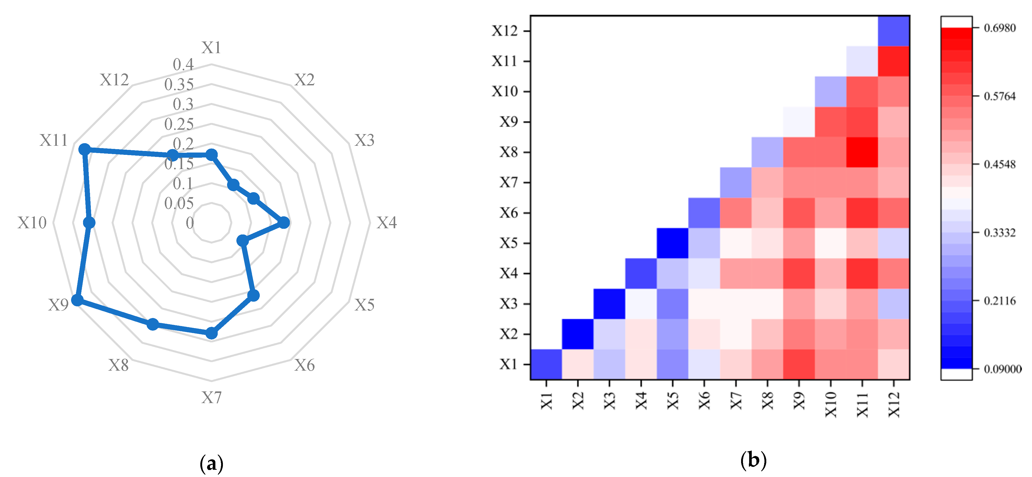
4.3.2. Interaction Detection of Factors

GeoDetector interactive factor detection was applied to identify the interactions among the 12 driving factors. The influence of two interaction factors, A and B, on the traditional villages in the hilly and gully areas of northern Shaanxi was compared to determine whether the influence factors affecting the spatial distribution of the traditional villages acted alone or had an interactive relationship. This analysis includes five relationships: (1) q A < min q A , q B shows that the two factors are weakly nonlinear; min q A , q B < q A B < max q A , q B indicates that the single-factor nonlinearity is weakened; q A B > max q A , q B indicates two-factor enhancement; q A B = q A + q B demonstrates that the two factors are independent of each other; and q A B > A + q B illustrates the nonlinear enhancement of the two factors. The heat map function in Origin was utilized to reflect the detection results (Figure 14b). It was found that the interaction effect of a composite factor was significantly more explanatory than that of a single factor, representing a nonlinear enhancement or two-factor enhancement effect, which indicates that the spatial distribution characteristics of the traditional villages in the hilly and gully areas of northern Shaanxi were a result of the combined actions of many factors (Appendix A Table A4). In addition, there are three indicators with the highest explanatory power, i.e., “X8 rainfall∩X11 population density, X11 population density∩X12 amount of intangible cultural heritage, X6 solar radiation∩X11 population density”, and it was found that the single factor “X11 population density” played a key role in the spatial distribution characteristics of the traditional villages. This further confirmed the role of the population agglomeration in the survival of the traditional villages. It is worth noting that the three interactive indicators with the greater explanatory power involve the interaction between population density and the climatic factors, which proves that the climate of the hilly and gully areas of northern Shaanxi has an important influence on the distribution of the settlements.

5. Discussion

5.1. Natural Environment Factors Are the Basis for Sustainable Development of Traditional Villages

Compared with villages on a plain, mountainous villages are more closely related to the natural environment. Topographic, hydrological, and climatic conditions are important factors that affect the formation and form of a village space and determine the production mode and spatial form of the villages. Limited by the mountainous terrain, the flat land suitable for agricultural production is scarce, and people usually choose an environment that is conducive to their own survival and development. The existence of villages is a result of the mutual adaptation of internal factors and environmental factors. Terrain fluctuations may affect the spatial pattern and building type of these villages. For example, in a valley terrace and a loess plateau area, which have small terrain fluctuations, the villages are mainly clustered, and the buildings are mostly in the form of independent cave dwellings; in hilly areas with a large relief, the villages mostly extend along rivers in strips, and the buildings are mostly mountain-style cave dwellings. People build their homes by adapting and changing nature. Appropriate water, light, heat, and land are the basis for the sustainable development of the traditional villages.

5.2. Social and Economic Factors Are Core Motivation for Distribution Characteristics of Traditional Villages

After a long period of development and construction, it is rare to see areas that are not affected by humans in northern Shaanxi, as people build settlements based on different natural conditions. With the development and vicissitude, people are affected by social and economic factors and human behavioral decisions and gradually adjust the functions and utilization patterns of their villages [49], generating ecological wisdom that adapts to the locality. Since the reform and opening-up of China, the rapid social and economic development of the country has had a huge impact on rural development, and many of the local characteristics of the rural areas have been lost. Actions for traditional village protection have been put forward, against the background of the rural revitalization strategy, in response to a cultural crisis regarding the rapid disappearance of villages [50]. The application and the approval of traditional villages are based on natural and humanistic values and have a strong social character. The traditional villages in the hilly and gully areas of northern Shaanxi are generally distributed in areas less affected by modernization and industrialization—that is, areas with a low urbanization rate, a low per capita GDP, and a high population density. In general, at the beginning of the formation of a village, its location and layout were mainly affected by the natural environment; nowadays, with great changes in the external environment, the social and economic environment is a core determinant of the continuation and development of the traditional villages.

6. Conclusions and Future Work

This paper takes 154 national and provincial traditional villages in the hilly and gully areas of northern Shaanxi as the research object and analyzes the spatial distribution characteristics and influence factors of these traditional villages. The main conclusions are summarized below.
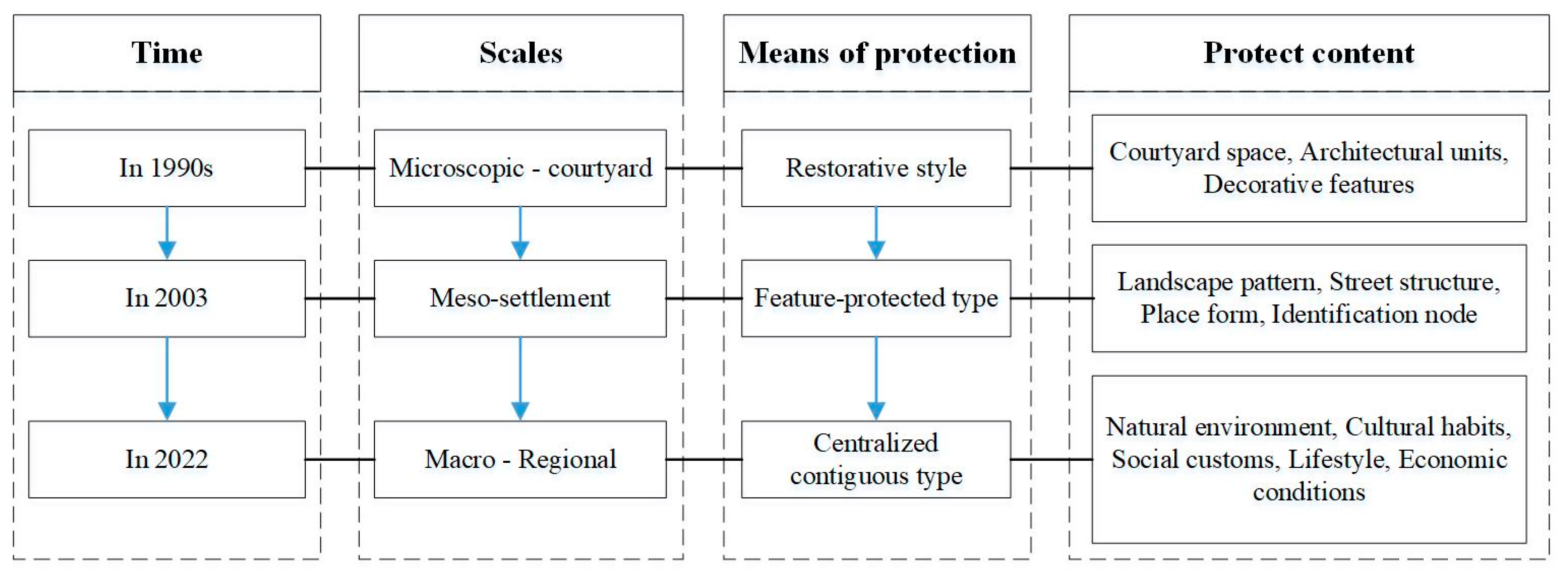
  • The spatial distribution of the traditional villages in the hilly and gully areas of northern Shaanxi presents an uneven agglomeration distribution, with Mizhi, Suide, and Jiaxian as the main core agglomeration areas and Yanchuan as a secondary core agglomeration area, and an outward radiation forms with the “dual-core” as the center.
  • Most of the traditional villages in the hilly and gully areas of northern Shaanxi are located in areas with a middle/high altitude of 700~1200 m and a slope of 10°~20° and in mountainous regions with a moderate relief with a south-facing aspect. The traditional villages are mostly located in the Wuding-Qingjian River Basin, within the 600 m river buffer area; the areas with an average annual temperature between 8.9 and 10.5 °C, an annual rainfall between 450 and 550 mm, and solar radiation between 5800 and 6000 MJ/m2 have a more concentrated distribution of villages. Among the influential factors, the distribution of the traditional villages is positively correlated with slope, average annual temperature, and solar radiation, and it is negatively correlated with the distance from a river; the elevation, aspect, terrain undulation, and rainfall are distributed in the middle.
  • Since the 1990s, the uneven development of the socio-economic level has had a great impact on the distribution of the traditional villages. Among them, in areas with high population density and low per capita GDP, there are more traditional villages, and the correlation between spatial distribution and the urbanization rate fluctuates.
  • The results of GeoDetector show that socio-economic factors, such as per capita GDP, population density, and urbanization rate, have the strongest influence on the spatial distribution of the traditional villages, followed by climate factors such as rainfall, average temperature, and solar radiation, while geographical factors, such as terrain undulation, elevation, aspect, slope, and distance from rivers, have a weak influence. The interaction enhancement effect of “rainfall ∩ population density, population density ∩ intangible cultural heritage, solar radiation ∩ population density” is the most obvious.
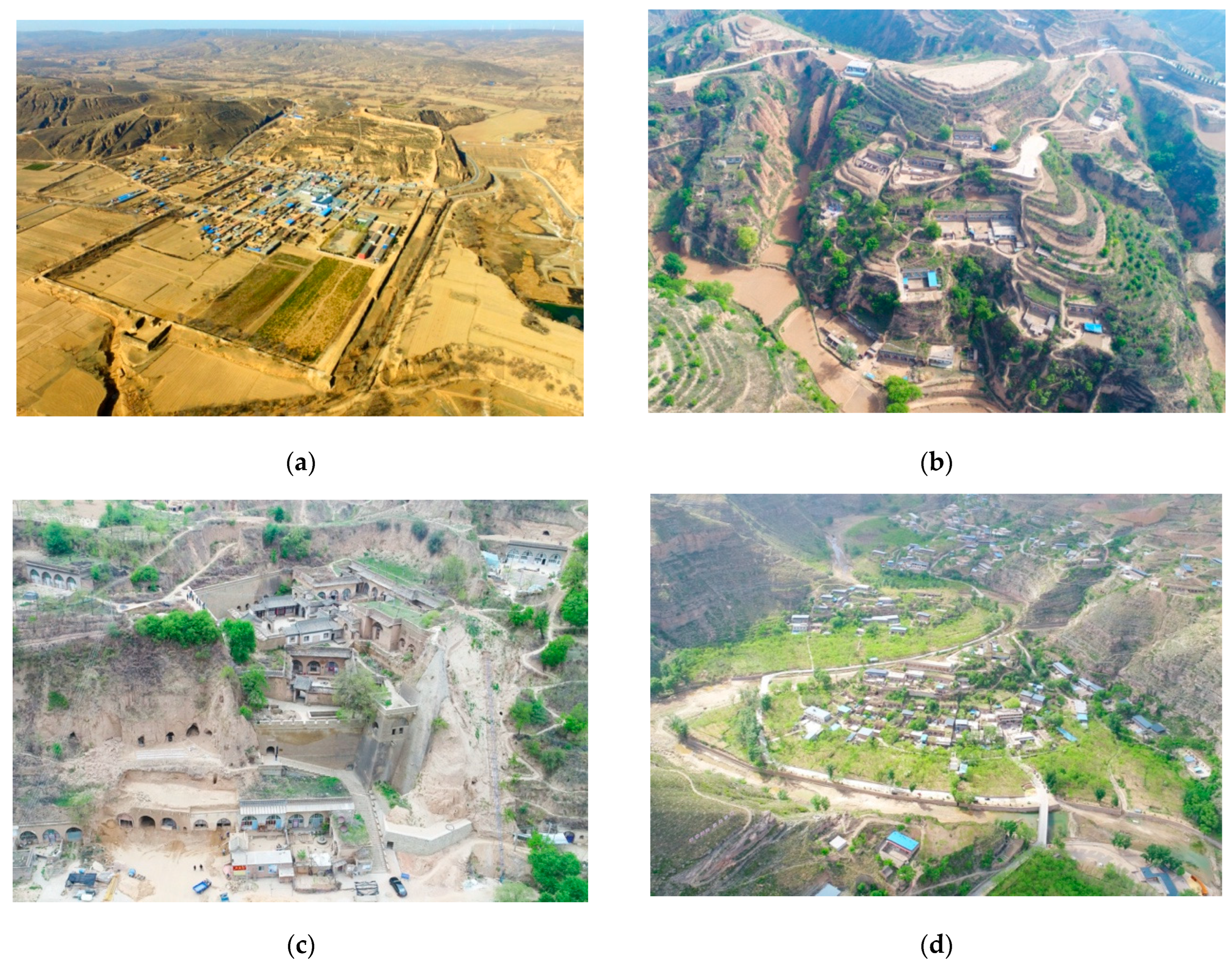
  • In terms of influence mechanisms, the natural environmental factors are the basis for the formation and development of the traditional villages, and the socio-economic factors determine their development direction. The locations of the loess hilly landform and the agro-pastoral transition zone have created a unique cave architecture and regional culture in the hilly and gully areas of northern Shaanxi. This is also the fundamental reason why the spatial distribution pattern of the traditional villages is different from that of other regions, indicating that the traditional villages are the result of long-term adaptations between man and nature.
The terrain of the hilly and gully areas of northern Shaanxi is complex, meaning that the development of the human settlement space is limited by the terrain, and it is difficult to form a large urban agglomeration area. The mountainous terrain formed a barrier for villages in the farming era and played a defensive role, but the inconvenient traffic conditions thereof affected people’s production and lives with the development of society. Therefore, as people increase their incomes, they usually choose to relocate to cities or towns, which further results in the depression of the villages. Therefore, in order to protect and develop traditional villages in the hilly and gully areas of northern Shaanxi, the following suggestions are proposed, including:
  • Promote the integrated development of traditional agriculture into primary, secondary, and tertiary industries, using traditional village tourism resources to develop tourism and the agricultural product processing industries and to drive economic growth in low-income areas with high population density.
  • Against the background of the transformation of the Loess Plateau from a warm-dry to a warm-humid climate, the trend of ecological deterioration is reversed through ecological restoration, and the climate comfort of the human settlement space is improved in the process of settlement transformation; overdevelopment is avoided, and the coordinated development of the human settlement environment and the ecological environment is promoted.
  • The protection of traditional villages should have a broader perspective, according to the characteristics of traditional village agglomeration and distribution, comprehensively and systematically delineating cultural areas of different types and functions, highlighting core regional cultures, and formulating special protection plans for village cultural areas.
The spatial distribution characteristics and influence factors of the traditional villages in the hilly and gully areas of northern Shaanxi are quantitatively analyzed from a macro perspective, providing a theoretical basis and the technical support for the overall protection and development of these traditional villages. This paper only analyzed the macroscopic characteristics of the distribution of the traditional villages in the hilly and gully areas of northern Shaanxi and did not involve the small-scale micro attribute characteristics and historical evolution laws of traditional villages. Therefore, the follow-up research will focus on the evolutionary process of traditional villages, explain their formation mechanisms, further analyze the spatial characteristics of the traditional villages, and explore the adaptation mechanisms of the traditional villages to topography, climate, and culture. This study provides research support and suggestions for the overall protection of traditional villages in the hilly and gully areas of northern Shaanxi and is conducive to the systematic construction of mountain human settlement construction methods in arid areas.

Author Contributions

Conceptualization, B.L. and J.W.; methodology, B.L.; software, B.L.; validation, B.L. and J.W.; formal analysis, B.L.; investigation, B.L., J.W. and Y.J.; resources, B.L. and Y.J.; data curation, B.L.; writing—original draft preparation, B.L.; writing—review and editing, B.L., J.W. and Y.J.; visualization, B.L.; supervision, J.W.; project administration, B.L. and Y.J.; funding acquisition, J.W. and Y.J. All authors have read and agreed to the published version of the manuscript.

Funding

This research was funded by the “Research on the Protection and Inheritance of Regional Cultural Gene in Shaanxi Traditional Villages”, grant number 2020J048, and the “Research on the co-evolution and social dynamic mechanism of rural settlement landscape in the hilly and gully area of northern Shaanxi”, grant number 2018K14.

Institutional Review Board Statement

Not applicable.

Informed Consent Statement

Not applicable.

Data Availability Statement

Not applicable.

Conflicts of Interest

The authors declare no conflict of interest.

Appendix A

Table A1. Traditional village evaluation and recognition index system.
CategoryEvaluate MethodIndexIndicator Decomposition
Traditional architecture of the villagequantitative assessmentLongevityThe earliest surviving building was built
ScarcityThe age of construction in a cluster of traditional buildings
ScaleThe level of cultural relics protection unit
ProportionTraditional building footprint
Proportion of the construction land area of the village
AbundanceTypes of building functions
qualitative assessmentCompletenessThe existing traditional buildings (groups) and their architectural details and even the surrounding environment are preserved
Aesthetic value of craftsmanshipThe existing traditional buildings (groups) have aesthetic values such as architectural shape, structure, materials, or decoration
Traditional craftsmanship is inheritedTraditional techniques are still widely used to create everyday life buildings
Site selection and layoutquantitative assessmentLongevityThe current site of the village was formed
AbundanceTypes of existing historical environmental elements
qualitative assessmentPattern integrityThe extent to which the traditional pattern of the village is preserved
Scientific and cultural valuesVillage site selection, planning, and creation reflect scientific, cultural, historical, and archaeological values
CoordinationThe village maintains a harmonious symbiotic relationship with the surrounding beautiful natural landscape environment or traditional idyllic scenery
Intangible cultural heritagequantitative assessmentScarcityLevel of intangible cultural heritage
AbundanceCategories of intangible cultural heritage
ContinuityContinuous inheritance time to the present
ScaleScale of legacy activities
InheritorsWhether there is a clear representative inheritor
qualitative assessmentLivenessInheritance
DependencyThe degree to which rituals, bearers, materials, crafts, and other practices related to intangible cultural heritage depend on the village and its surrounding environment
Table A2. Statistical table of influencing factors of traditional villages.
No.NameNuclear DensityElevationSlopeAspectTerrain ReliefDistance to RiverSolar RadiationAverage TemperatureRainfallGDP per CapitaUrbanization RatePopulation DensityNumber of Intangible Cultural Anomalies
1Luojian0.00411135214532
2Jiadamao0.00414125213332
3Xiangshui0.00313125213332
4Wulongshan0.00313115213332
5Wangpizhuang0.00414125213332
6Zhenjing0.00513145214424
7Heyi0.02344413431254
8Aijiagou0.02333333431254
9Changjiagou0.02344313431254
10Guojiagou0.02333323431254
11Huyan0.01443453441254
12Liangjiajia0.02433333431254
13Zhongjiao0.02444313431254
14Yangjiagou0.03433214321253
15Gaomiaoshan0.03334214321253
16Taozhen0.03433224321253
17Heigeta0.03433314321253
18Sigou0.03435314321253
19Yujiacha0.03334214321253
20Baixingzhuang0.01322214321253
21Liujiamao0.03433324321253
22Zhenziwan0.02221114321253
23Shenquan0.01223124222142
24Zhangzhuang0.01223344222142
25Shaping0.02243323332142
26Yukou0.01132444222142
27Nihegou0.00231424212142
28Mutouyu0.01121134322142
29Heyeping0.01141423332142
30Liujiaping0.01132213332142
31Gaojie0.01134422442242
32Zhangzhai0.00221344422243
33Mianhugou0.00453413332243
34Yuanzeping0.00343414422243
35Zhenshi0.00333521552555
36Anding0.00543532331433
37Zhaojiahe0.01343412443422
38Liangjiahe0.01353512443422
39Majiawan0.02344512443422
40Shangtianjia0.01352522433422
41Zhenjiawan0.02243512443422
42Taixiangsi0.02242522443422
43Nianpan0.01123342453422
44Liujiashan0.01121332453422
45Liangshui’an0.01131451551211
46Fangya0.00323224214532
47Zhaiwa0.01215144324532
48Chenjiapo0.02215134324532
49Lijiawa0.01211124115421
50Sunshike0.00223134115421
51Caiyuangou0.00423214115421
52Shamaotou0.00411134115421
53Wenlujia0.00423214115421
54Huangfu0.00512154115421
55Chengnei0.01211114115421
56Hazhen0.01212134115421
57Shaliang0.00322234115421
58Mugua0.02444313431254
59Yujiaping0.02344313431254
60Qianyuanze0.02242323431254
61Yaoqu0.01234314421254
62Ciyaogou0.02122313431254
63Shengou0.01242414521254
64Sanshilipu0.01233313431254
65Sunjiacha0.02222313431254
66Zhifanggou0.02423253431254
67Xuejiamao0.02354413431254
68Haojiaqiao0.02254413431254
69Tianzhuang0.02112233431254
70Haimanping0.01123333431254
71Qianping0.02244413431254
72Wangjiagou0.02322433431254
73Leijiagou0.02335313431254
74Tiejiaping0.02343314321254
75Sujiageta0.01333314421254
76Zhifanggou0.02335324421254
77Xuejiaqu0.01243314521254
78Heijiagou0.02343314331254
79Qizhen0.01121223441254
80Gaojiagou0.03334214321253
81Leijiacha0.02332224321253
82Houjiaping0.02333244321253
83Shizileng0.02333244321253
84Qianping0.00423254321253
85Lijiata0.02342314321253
86Gaoxigou0.02211134321253
87Jiqiao0.01321234211253
88Dujiashigou0.01424114214532
89Liujiawa0.02334224321253
90Tianwangta0.01333214321253
91Heishiyao0.03434214321253
92Mahuyu0.03434314321253
93Lijiazhan0.03333234321253
94Zhangjiaya0.01432244321253
95Mutouzegou0.02433214321253
96Zhejiagelao0.02225214321253
97Gongjiaqiao0.02214134321253
98Majiazeyuan0.01232314322142
99Lvjiajian0.00131433442351
100Hongyawa0.01244233442351
101Jingjiagou0.02243423332351
102Wangshagou0.02344323332351
103Leijiamao0.01243412442242
104Aodian0.01124342442242
105Jingjiahe0.01132432442242
106Wangping0.01235412432242
107Chiniuwa0.01344323432243
108Chengli0.00321333322243
109Gaojiazhuang0.00352532442555
110Gaojialeng0.01352512442555
111Sigou0.00443431552555
112Yuanjiagou0.01543431442555
113Yuanjiagou0.00452521342555
114Wangsuli0.00331431342555
115Shitaisi0.00334421342555
116Wangjiabao0.00552511442555
117Xuejiachengze0.00533431343313
118Yingpan0.00544443321433
119Dongzhen0.01443422331433
120Gutun0.01342522443422
121Mafang0.02242522443422
122Maojiabaoze0.02253512443422
123Miaogou0.02244532443422
124Lizhuang0.02254512443422
125Kangping0.01353512443422
126Longsi0.01353522443422
127Weita0.01343452443422
128Zhoujiashan0.01353512443422
129Resiwan0.01253512443422
130Zhaojiayadi0.02343522443422
131Weijiacha0.00132442443422
132Shiyaotai0.01141541551211
133Gaojiagetai0.01121341551211
134Liujiagou0.00553511234414
135Liumajiageta0.00553521234414
136Sheyou0.00544511344414
137Zhangjiahe0.00543421234414
138Lvjiahe0.00533422134414
139Qiaojiahe0.00432324323332
140Xiadamu0.01414115213332
141Wacunhe0.00342314215524
142Tuojiachuan0.00112124215524
143Suanjiageta0.00122334215524
144Xinshenggu0.02332214321253
145Majiadian0.02332214321253
146Si0.02333214321253
147Tianjiayuan0.02235233431254
148Shangpo0.01354413432242
149Xiapo0.00121342443422
150Baishachuan0.02352512443422
151Diaoping0.01454552443422
152Malaozhuang0.00332412431433
153yaozichuan0.00432413331433
154Jintang0.00453524321433
Table A3. Single-factor detection results of driving factors for the spatial distribution of traditional villages.
X1X2X3X4X5X6X7X8X9X10X11X12
q statistic0.170.110.120.180.090.210.280.300.390.310.370.20
p value0.000.000.010.000.010.000.000.000.000.000.000.00
Table A4. The detection results of the interaction of driving factors in the spatial distribution of traditional villages.
X1X2X3X4X5X6X7X8X9X10X11X12
X10.1713-----------
X20.42830.1101----------
X30.32710.33540.1223---------
X40.41920.43200.38840.1823--------
X50.25340.28250.24180.32090.0908-------
X60.37280.43340.39490.36360.32360.2120------
X70.44660.40220.39790.50870.39990.54260.2791-----
X80.50450.47380.39960.51330.41560.47060.49070.2963----
X90.60040.54680.51420.60740.50330.57840.53030.57220.3909---
X100.53100.49680.43900.49060.40680.51320.52460.57210.59480.3088--
X110.52100.53000.50910.63140.46390.63290.53530.69710.61120.59000.3699-
X120.43620.47830.33020.54600.34100.55660.48420.50260.47990.53910.65650.1963

References

  1. Wu, F.Q.; Zhou, K. Less is more—Rural planning from the perspective of village cultural landscape. J. Hum. Settl. West China 2015, 30, 44–49. [Google Scholar]
  2. Li, B.H.; Yin, S.; Liu, P.L.; Dou, Y.D. Spatial distribution of traditional villages and the influencing factors in Hunan Province. Econ. Geogr. 2015, 35, 189–194. [Google Scholar]
  3. Xu, J.H.; Le, B.M.; Mao, Z.; Liu, S. Influencing Factors and Protection Modes of the Spatial Pattern of Traditional Villages in Hunan Province. Econ. Geogr. 2020, 40, 147–153. [Google Scholar]
  4. Yin, W.; Chen, P.D.; Qin, J.; Chen, L.L.; Xie, K.; Li, G. Bashu cultural corridor construction research: Spatial distribution characteristics and influencing factors of national traditional villages in Chengdu-Chongqing Region. Chin. Overseas Arch. 2022, 6, 42–47. [Google Scholar]
  5. The Ministry of Housing and Urban-Rural Development and Other Departments Announced the List of Traditional Chinese Villages. Available online: http://www.chuantongcunluo.com/ (accessed on 22 August 2022).
  6. The Central Committee of the Communist Party of China and the State Council Issued the Strategic Plan for Rural Revitalization (2018–2022). Available online: http://www.gov.cn/xinwen/2018-09/26/content_5325534.htm (accessed on 29 October 2022).
  7. Zhang, Y.; Jia, Y.F.; He, Y. The Study of Integrated Conservation Method of Traditional Plain Bao-village, taking Pingyao historic villages as an example. Urban Dev. Stud. 2015, 22, 104–110. [Google Scholar]
  8. Long, B.; Zhao, Y. Village Landscape Characteristics and Evolution of Tengchong in Yunnan from the Regional Perspective. South Archit. 2022, 5, 35–44. [Google Scholar]
  9. Gauthiez, B. The History of urban morphology. Urban Morphol. 2004, 8, 72. [Google Scholar] [CrossRef]
  10. Williams, M. The Apple of my eye: Carl Sauer and Historical Geography. J. Hist. Geogr. 1993, 9, 1–28. [Google Scholar] [CrossRef]
  11. Sauer, C.O. The Fourth Dimension of Geography. Ann. Assoc. Am. Geogr. 1974, 64, 189–192. [Google Scholar] [CrossRef]
  12. Erik, G.B.; Victoria, R.G.; Per, O.; Carlos, M. Traditional ecological knowledge and community resilience to environmental extremes: A case study in Doñana, SW Spain. Glob. Environ. Chang. 2012, 22, 640–650. [Google Scholar]
  13. Álvaro, F.L.; Isabel, D.R.; Ana, C.L.; Mar, C.; Aili, P.; Victoria, R.G. Rapid ecosystem change challenges the adaptive capacity of Local Environmental Knowledge. Glob. Environ. Chang. 2015, 31, 272–284. [Google Scholar]
  14. Xu, Q.; Wang, J. Recognition of Values of Traditional Villages in Southwest China for Sustainable Development: A Case Study of Liufang Village. Sustainability 2021, 13, 7659. [Google Scholar] [CrossRef]
  15. Chen, C.L.; She, Y.C.; Chen, Q.X.; Liu, S.F. Study on ecological adaptability of traditional village construction in Hainan volcanic areas. J. Asian Archit. Build. Eng. 2022, 3. [Google Scholar] [CrossRef]
  16. Wang, R.Q.; Shao, Y.R.; Peng, W.H. Cultural Landscape Reshaping Path with Rural Revitalization as the Background. South Archit. 2022, 10, 99–105. [Google Scholar]
  17. Yu, H.; Verburg, P.H.; Liu, L.M.; Eitelberg, D.A. Spatial Analysis of Cultural Heritage Landscapes in Rural China: Land Use Change and Its Risks for Conservation. Environ. Manag. 2016, 57, 1304–1318. [Google Scholar] [CrossRef]
  18. Željka, Č.; Milić, Č.; Velibor, S.; Milorad, J.; Paul, S.; Svetislav, G.P. Identification and Evaluation of Landscape as a Precondition for Planning Revitalization and Development of Mediterranean Rural Settlements—Case Study: Mrkovi Village, Bay of Kotor, Montenegro. Sustainability 2019, 11, 2039. [Google Scholar]
  19. Marta, D.; Róbert, K.; Stanislav, D.; Jozef, K.; Jana, Š.; Dagmar, Š.; Matej, M.; František, P.; Anton, K.; Slavomír, S.; et al. Assessment of the biocultural value of traditional agricultural landscape on a plot-by-plot level: Case studies from Slovakia. Biodiverse. Conserv. 2019, 28, 2615–2645. [Google Scholar]
  20. Sprague, D.S. Land-use configuration under traditional agriculture in the Kanto Plain, Japan: A historical GIS analysis. Int. J. Geogr. Inf. Sci. 2013, 27, 68–91. [Google Scholar] [CrossRef]
  21. Yang, Q.; Zhang, F.T.; An, Y.Z.; Sun, C.C.; Wu, J.F.; Zhang, Y.; Wei, Z. Discrete Dynamics in Nature and Society. Discret. Dyn. Nat. Soc. 2021, 3, 2. [Google Scholar]
  22. Xie, Y.C.; Meng, X.Z.; Cenci, J.; Zhang, J. Spatial Pattern and Formation Mechanism of Rural Tourism Resources in China: Evidence from 1470 National Leisure Villages. ISPRS Int. J. Geo-Inf. 2022, 11, 455. [Google Scholar] [CrossRef]
  23. Qi, J.W.; Lu, Y.Y.; Han, F.; Ma, X.K.; Yang, Z.P. Spatial Distribution Characteristics of the Rural Tourism Villages in the Qinghai-Tibetan Plateau and Its Influencing Factors. Int. J. Environ. Res. Public Health 2022, 19, 9330. [Google Scholar] [CrossRef] [PubMed]
  24. Chen, H.L.; Xu, J.B.; Yang, W.Y.; Cao, X.S. Study on the spatial correlation between traditional villages and poverty-stricken villages and its influencing factors in China. J. Nat. Resour. 2021, 36, 3156–3169. [Google Scholar] [CrossRef]
  25. Li, B.; Yang, B.; Tao, Q.H.; Zuo, L.P.; Gao, H.; Liu, Y.X.; Li, W. Study on spatial patern and influencing factors of traditional vilages in Hunan province. Sci. Surv. Mapp. 2021, 46, 150–157. [Google Scholar]
  26. Nie, Z.; Li, N.; Pan, W.; Yang, Y.; Chen, W.; Hong, C. Quantitative research on the form of traditional villages based on the space gene—A case study of Shibadong village in western Hunan, China. Sustainability 2022, 14, 8965. [Google Scholar] [CrossRef]
  27. Wang, J.F.; Xu, C.D. Geodetector: Principle and prospective. Acta Geogr. Sinica. 2017, 72, 116–134. [Google Scholar]
  28. Hu, J.L.; Teng, Y.B.; Fan, Y.M.; Li, L.P. Spatial distribution and influencing factors of traditional villages in Guangxi Zhuang Autonomous Region. J. Guilin Univ. Technol. 2021, 41, 580–588. [Google Scholar]
  29. Gao, N.; Wu, C.; Bai, K.; Ma, Y.F. Patial diferentiation and influencing factors of Chinese traditional vilages. J. Shanxi Norm. Univ. 2020, 48, 97–107. [Google Scholar]
  30. Li, J.S.; Wang, X.R.; Li, X.J. Spatial Distribution Characteristics and Influencing Factors of Chinese Traditional Villages. Econ. Geogr. 2020, 40, 143–153. [Google Scholar]
  31. Dong, Y.P.; Liu, S.P.; Xu, X.W.; Su, J. The watershed characteristics of spatial distribution of Chinese traditional villages. J. Northwest Univ. 2021, 51, 128–142. [Google Scholar]
  32. Ji, X.X.; Yang, C.C.; Zhao, M.W.; Xu, Y.; Zhou, D.M.; Zhang, Y.W. Spatial Distribution Characteristics and Influencing Factors of Traditional Villages in Zhejiang, Anhui, Shaanxi, Yunnan Provinces. Econ. Geogr. 2022, 42, 222–230. [Google Scholar]
  33. Huang, H.J.; Miao, H.; Li, S.; Wang, Y. Spatial Pattern and Influence Mechanism of Traditional Villages in Northwest China. Econ. Geogr. 2021, 41, 230–240. [Google Scholar]
  34. Wang, Z.F.; Li, Q.; Wu, W. Genome Map Construction of the Cultural Heritage Landscape and Its Characteristics in Traditional Villages of Wuling Mountain Area. Econ. Geogr. 2021, 41, 225–231. [Google Scholar]
  35. Zhang, S.W.; Lin, N.G.; Yan, Z. Invesitgation on the Topology and Evolution of Traditional Settlements in Shatian Region of Pearl River Delta. South Archit. 2022, 3, 28–37. [Google Scholar]
  36. Liu, H. The Regional Small Watershed Units of Human Settlements and the Security Models on the Loess Plateau: Research from Analyzing of the Landscape Pattern. Ph.D. Thesis, Xi’an University of Architecture and Technology, Xi’an, China, 2005. [Google Scholar]
  37. Shi, Y.F.; Shen, Y.P.; Hu, R.Y. Preliminary Study on Signal, Impact and Foreground of Climatic Shift from Warm-Dry to Warm-Humid in Northwest China. J. Glaciol. Geocryol. 2002, 3, 219–226. [Google Scholar]
  38. He, W.M. Northern Shaanxi Hilly Area Rural Settlements Transformation and Development Research Based on Returning Farmland to Forest. Ph.D. Thesis, Xi’an University of Architecture and Technology, Xi’an, China, 2014. [Google Scholar]
  39. The Ministry of Housing and Urban-Rural Development and Other Departments Issued the Notice on the Evaluation and Identification Index System of Traditional Villages (Trial). Available online: https://www.mohurd.gov.cn/gongkai/fdzdgknr/tzgg/201208/20120831_211267.html (accessed on 29 October 2022).
  40. Shaanxi Provincial Department of Housing and Urban-Rural Development and Other Departments Announced the List of Traditional Villages in Shaanxi Province. Available online: https://js.shaanxi.gov.cn/ (accessed on 22 August 2022).
  41. Xu, X.; Genovese, P.V.; Zhao, Y.; Liu, Y.; Woldesemayat, E.M.; Zoure, A.N. Geographical distribution characteristics of Ethnic-Minority villages in Fujian and their relationship with topographic factors. Sustainability 2022, 14, 7727. [Google Scholar] [CrossRef]
  42. Wang, Y.Y. Extract and analysis topographic factors of Loes Plateau in northern Shaanxi based on DEM. Land Dev. Eng. Res. 2019, 12, 28–36. [Google Scholar]
  43. Wu, L.Y. Exploration of Human Settlement Science. Planners 2001, 6, 5–8. [Google Scholar]
  44. Gao, Y. The circumvention of “Resource Cruse” and the construction of new urbanization in the “New Normal” energy: A case study of energy-rich region in North Shaanxi. City Plan. Rev. 2015, 39, 52–59. [Google Scholar]
  45. He, X.Q.; Gong, S.S.; Hu, J.; Xu, J.J. Spatial Differentiation and It’s Influence Factors of Traditional Villages in Hunan, Hubei and Jiangxi Provinces at Different Scales. Resour. Environ. Yangtze Basin 2019, 28, 2857–2866. [Google Scholar]
  46. Feng, J.C. The predicament and way out of traditional villages—Traditional villages are another kind of cultural heritage. Folk Cult. Forum 2013, 01, 7–12. [Google Scholar]
  47. Wang, P.J.; Zhang, J.H.; Sun, F.; Cao, S.S.; Kan, Y.; Wamg, C.; Xu, D. Spatial Distribution and the Impact Mechanism of Traditional Villages in Southwest China. Econ. Geogr. 2021, 41, 204–213. [Google Scholar]
  48. Kamila, J.K.; Tang, G.A.; Yang, X.; Na, J.; Xiong, L.Y. Spatial Fractal Properties of Loess Plateau in the Northern Shaanxi Province of China. J. Nanjing Norm. Univ. 2020, 43, 56–62. [Google Scholar]
  49. Wang, G.Q.; Liu, S.F. Research on the complex adaptability of urban architectural heritage in the period of inventory planning: A case study of Harbin city. Mod. Urban Res. 2020, 8, 108–114. [Google Scholar]
  50. Wang, S.Y.; Sun, J.X. National discourse and local practice of traditional village protection from the perspective of rural revitalization. J. Guangxi Univ. Natly. 2021, 43, 124–131. [Google Scholar]
Figure 1. The process of the protection of traditional Chinese settlements.
Sustainability 14 15327 g001
Figure 2. Sustainable development mechanism of traditional villages under the influence of multiple factors.
Sustainability 14 15327 g002
Figure 3. Location of the loess hilly and gully areas in northern Shaanxi in China.
Sustainability 14 15327 g003
Figure 4. Analysis of the distribution of traditional villages in the hilly and gully areas of northern Shaanxi: (a) average nearest neighbor index map of traditional villages; (b) Thiessen polygon distribution map of traditional villages.
Sustainability 14 15327 g004
Figure 5. Lorenz curve of traditional village distribution.
Sustainability 14 15327 g005
Figure 6. Kernel density analysis of traditional villages.
Sustainability 14 15327 g006
Figure 7. Distribution of traditional villages under the influence of topography: (a) correlation diagram of traditional village distribution and elevation; (b) correlation diagram of traditional village distribution and slope; (c) correlation diagram of traditional village distribution and slope aspect; (d) correlation diagram of traditional village distribution and terrain relief.
Sustainability 14 15327 g007
Figure 8. Distribution of traditional villages under the influence of river systems: (a) correlation diagram of traditional village distribution and river grade; (b) correlation diagram of traditional village distribution and river basin division; (c) correlation diagram of traditional village distribution and river buffer zone.
Sustainability 14 15327 g008
Figure 9. Distribution of traditional villages under the influence of the climate environment: (a) correlation diagram of traditional village distribution and average annual temperature; (b) correlation diagram of traditional village distribution and rainfall; (c) correlation diagram of traditional village distribution and solar radiation.
Sustainability 14 15327 g009
Figure 10. Distribution of traditional villages under the influence of socioeconomic situation: (a) scope of energy-rich areas in northern Shaanxi; (b) correlation diagram of traditional village distribution and population density; (c) correlation diagram of traditional village distribution and urbanization rate; (d) correlation diagram of traditional village distribution and per capita GDP.
Sustainability 14 15327 g010
Figure 11. Spatial forms of different types of traditional villages: (a) village of military frontiers; (b) village of post houses; (c) village of manors; (d) farming village.
Sustainability 14 15327 g011
Figure 12. Correlation diagram between the distribution of traditional villages and the quantity of intangible cultural heritage.
Sustainability 14 15327 g012
Figure 13. Spatial distribution frequency map of traditional villages. The statistical results were divided into 5 categories from low to high, and the frequency chart was calculated. Among them, the aspect analysis was divided into three categories: southwest, south, and southeast. (a) Altitude distribution frequency plot; (b) slope distribution frequency plot; (c) spectrum distribution frequency plot; (d) terrain undulation distribution frequency plot; (e) distance from a river distribution frequency plot; (f) average annual temperature distribution frequency plot; (g) rainfall distribution frequency plot; (h) solar radiation distribution frequency plot; (i) population density distribution frequency plot; (j) urbanization rate distribution frequency plot; (k) GDP per capita distribution frequency plot; (l) intangible cultural heritage distribution frequency plot.
Sustainability 14 15327 g013
Figure 14. Results of GeoDetector factor detection: (a) single-factor detection results; (b) interaction detection results.
Sustainability 14 15327 g014
Table 1. Statistical analysis models and their geographical significance.
IndicatorFormulaExplanationSignificance
Average Nearest Neighbor Index R = r 1 ¯ r E = 2 D In the formula, r 1 ¯ is the nearest distance, and r E is the theoretical nearest distance.Quantitatively determines the type of distribution of point features within an area. When R > 1, the distribution of point elements is uniform; when R = 1, the dotted features are random; when R < 1, the dotted features have a tendency to agglomerate and distribute.
Voronoi Diagram C v = R / s ¯ In the formula, R is the standard deviation of the polygon area of Tyson, and s ¯ is the average of the polygon area of Tyson.The degree to which the reaction points change relative to each other in space. If 33 % < C v < 64 % , the dotted elements are randomly distributed. If C v 64 % , the point elements are agglomerated. If C v 33 % , the dotted features are evenly distributed.
Imbalance Index S = i = 1 n Y i 50 n + 1 100 n 50 n + 1 In the formula, n is the number of districts and counties, and Y i is the percentage of traditional villages in each district and county in the ith place after ranking the proportion of the total number of study areas from largest to smallest.Reflects the balance of traditional villages in different areas. S is between 0 and 1, and the larger the S value, the higher the imbalance. If the traditional villages are evenly distributed in all districts and counties, then S = 0 , and if the traditional villages are all concentrated in one district and county, then S = 1 .
Index of Geographic Concentration G = 100 × i = 1 n x i T 2 In the formula, x i is the number of traditional villages in the ith district, n is the number of districts and counties, and T is the total number of traditional villages.An important indicator to measure the concentration of traditional villages. The value of G is between 0 and 100; the larger the G-value, the more concentrated the distribution of traditional villages; the smaller the G-value, the more dispersed the distribution.
Kernel Density Analysis λ h ^ s = i = 1 n 3 π h 4 ( 1 s s i 2 h 2 ) 2 In the formula, s is the location of the traditional village to be estimated, s i is a traditional village with s as the center, and h is the location of the ith traditional village within the radius space.Observe. the cohesion of point features throughout the study area. The larger the λ h ^ s -value, the denser the dotted features.
GeoDetector q = 1 h = 1 L N h σ h 2 N σ 2 In the formula, the q value is a measure of the detection force of the independent variable—the value is [0, 1], and the closer to 1, the greater the influence of the factor. L is the stratification of the independent or dependent variable, N h and σ h 2 are the number of elements and the variance of layer h, respectively, and N and σ 2 are the number of units and the variance of the whole, respectively.In this paper, the factor detection method in GeoDetector is used to analyze the strength of each factor on spatial differentiation.
Table 2. Statistics on distribution of traditional villages in counties (districts).
City/County/District NameQuantity of VillagesPercentage (%)
YulinYuyang42.60
Hengshan63.90
Shenmu31.95
Fugu95.84
Jingbian10.65
Suide3019.48
Mizhi3019.48
Jiaxian95.84
Wubao42.60
Qingjian63.90
Zizhou53.25
Yan’anBaota95.84
Ansai10.65
Zichang63.90
Yanchuan2314.94
Yanchang31.95
Zhidan53.25
Publisher’s Note: MDPI stays neutral with regard to jurisdictional claims in published maps and institutional affiliations.

