Article

Digitalisation of Agricultural Production for Precision Farming: A Case Study

by
Karina R. Mukhamedova
1,
Natalya P. Cherepkova
1,
Alexandr V. Korotkov
1,
Zhanerke B. Dagasheva
1 and
Manuela Tvaronavičienė
2,3,*
1
Institute of Engineering and Information Technologies, Kazakh-British Technical University, Almaty 050000, Kazakhstan
2
Department of Business Technologies and Entrepreneurship, Vilnius Gediminas Technical University (VILNIUS TECH), Sauletekio 11, LT-10223 Vilnius, Lithuania
3
Institute of Humanities and Social Sciences, Daugavpils University, Parades Str. 1-421, LV-5401 Daugavpils, Latvia
*
Author to whom correspondence should be addressed.
Sustainability 2022, 14(22), 14802; https://doi.org/10.3390/su142214802
Submission received: 17 September 2022 / Revised: 20 October 2022 / Accepted: 4 November 2022 / Published: 10 November 2022
(This article belongs to the Collection Digitalization and Sustainable Development)

Abstract

:
The introduction of a digital platform for practical use at an agro-industrial enterprise is of great practical importance for the development of precision farming. Modern digital information systems are an integral part of precision farming and, in many ways, their foundation. During the work on the Farm Management Information Systems (FMIS) project, software and methodological framework for the use of precision farming techniques and information technologies for managing the process of growing crops in the field was developed. The introduction of a digital platform was carried out as an important experiment. Research methods such as bibliographic analysis and statistical processing were used. This study used modelling and statistical estimation of parameters. The findings were used to estimate the volume of transactions. In addition, during the experiment, communication schemes were worked out. The channel for receiving and transmitting information was tested, along with the channel-forming equipment (routers, switches, gateways) and the basic settings. The study checked the integration of the platform with external systems. A test was carried out for the passage of digital signals to the platform, including various electronic forms and reports. The recommendation for the policy planner is to ensure the required accuracy of the results. The practical value of our findings is that the electronic recording and preservation of the history of fieldwork and crops can help agro-industry workers in preparing special reports on the production cycle.

1. Introduction

The digitalisation of agricultural production management systems at the system level is being used in Kazakhstan for the first time [1,2,3]. The technologies used today on most farms are significantly outdated, and new, successfully used progressive methods in the world have not yet received due attention and development in Kazakhstan [4]. However, it is impossible to ensure food safety without a thorough approach. The problem of reforming the agro-industrial complex is particularly relevant today [5]. The introduction of new high-tech farming methods is necessary, which would help increase soil fertility, obtain stable yields at optimal costs, and help the entire agro-industrial complex enter a new path of innovative development. Without this, food security will be impossible.
The agro-industrial complex (AIC) actively uses the achievements of modern science. Information technologies began to penetrate the agricultural complex, especially in the era of digital projects [6,7]. Successful farms make decisions based on information from weather stations, drones, satellites, sensors and other devices that monitor the situation on the field [8,9,10]. A. Berger [11] considers that this allows enterprises to complete all agricultural activities in a timely manner by implementing a precision farming system, minimising decision-making time, risks and production costs. In order to harvest the crop in the shortest possible time with a minimum fleet of agricultural machinery and minimise the cost-of-service life, companies use automated driving technology with computer night vision (drones) [12,13,14,15,16].
According to Z. Lv [17], coordinated (precision) agriculture is a combination of technical resources, applications and hardware systems, navigation, geological information and telecommunication technologies that allow capturing, processing and applying coordinate-related information to maximise agricultural production. The main difference from the traditional concept of agriculture is that precision farming is tied to certain navigation coordinates and considers it a unit of accounting [17,18,19]. M. Carolan [20] thinks that, based on the collected and processed data, this concept includes the application of strictly defined and justified agro-technological methods to the cultivation of certain crops in each territory. Technology transfer as a concept is closely related to the theory of economic development and acts as the main form of promoting innovations that contribute to improving the welfare of society, while the subject of special attention is the issue of effective implementation of the acquired knowledge and technology in the production of public goods [21,22,23]. V. Galaz et al. [24] assert that the main purpose of the precision farming system is to determine the advantages. This approach describes the needs of crops and soil for optimal productivity on the one hand and resource protection and environmental sustainability on the other [25,26,27].
However, the issue of developing theoretical and conceptual aspects of development in the context of the functioning of the technology transfer system remains unresolved. The present article is an attempt to fill this gap. Therefore, the purpose of this article is to create a digital platform for the development of precision farming. The Institute of Engineering and Information Technologies of the Kazakh-British Technical University and the Kazakh Research Institute for Plant Protection and Quarantine implemented the Farm Management Information Systems (FMIS) project. During their work on the project, software and methodological framework for the use of precision farming techniques and information technologies for managing the process of growing crops in the field were developed.
The optimisation of the system of transfer technologies in the agricultural sector to increase the efficiency of innovative development, based on the set goal, was included in the tasks of this study: to investigate the concept of “technology transfer”; to study the available organisational forms of technology transfer in the agricultural sector; as well as to develop recommendations for improving the efficiency of technology transfer in the agricultural sector. The research questions were as follows:
1. Is the implementation of a digital platform for use in an agro-industrial enterprise of practical importance for the development of precision agriculture?
2. Does the developed interface of the Farm Management Information Systems allow for the carrying out of all actions necessary for the management of technological operations?

2. Materials and Methods

2.1. Data Collection Procedure

The theoretical and methodological basis of the study is formed by the basic concepts of economics and management in the agro-industrial complex, which were considered in a wide range of studies on the introduction of digital technologies in the agro-industrial complex. This study used the following methods: monographic, abstract-logical, computer and constructive, economic and statistical, comparative analysis and grouping, the expert assessments method, the theory of algorithms, personal participant observation, and the graphical method.
The technology of transfer, adaptation and development of information technologies for agro-industrial production was applied in this study. As an important experiment, the introduction of a digital platform on the servers of the Kazakh Research Institute of Plant Protection and Quarantine was carried out. During the experiments, the digital platform was prototyped, key components were assembled, basic functions were checked, and the entire architecture was tested for operability. In addition, during the experiment, communication schemes were worked out. The channel for receiving and transmitting information was tested, along with the channel-forming equipment (routers, switches, gateways) and the basic settings. This study checked the integration of the platform with external systems by carrying out a test for the passage of digital signals to the platform, including various electronic forms and reports. The following research methods were used:
Bibliographic analyses, which involve a bibliographic search in periodicals, analysis of internet sources, and applied technical literature;
Statistical processing of the digital platforms’ collected information by conducting statistical research and calculations during development.

2.2. Data Analysis

The analysed information included the analysis and classification of the parameters and telecommunications infrastructure, including in rural areas. A comparative analysis method was used when designing the platform architecture and selecting information resources. Data processing and classification tools in the R programming language were used for all research methods [2]. It is necessary to determine what precision farming is and what its advantages are for farmers to understand the principles of precision farming. This method is also known as site-specific crop management. This concept includes the observation, measurement, and response to external and internal changes in agricultural crops in the fields using information technology (IT).
This study used modelling and statistical estimation of parameters. The findings were used to estimate the volume of transactions and storage information, the number of users and accesses to the platform, and the capacity of servers and data storage systems. Models for evaluating the reliability of systems were used to assess the stability and reliability of the information security of the platform. Statistical estimation in the R programming language was followed for the recording of the qualitative and quantitative data of crops. Additionally, it was used to model and analyse the processes of the digital platform. The transfer and adaptation of modern technologies, knowledge and skills were carried out in accordance with the modern methodology for the dissemination of agrotechnical knowledge and technologies and based on the recommendations of the Food and Agriculture Organization of the United Nations and other international organisations [3,4,5,6].

3. Results

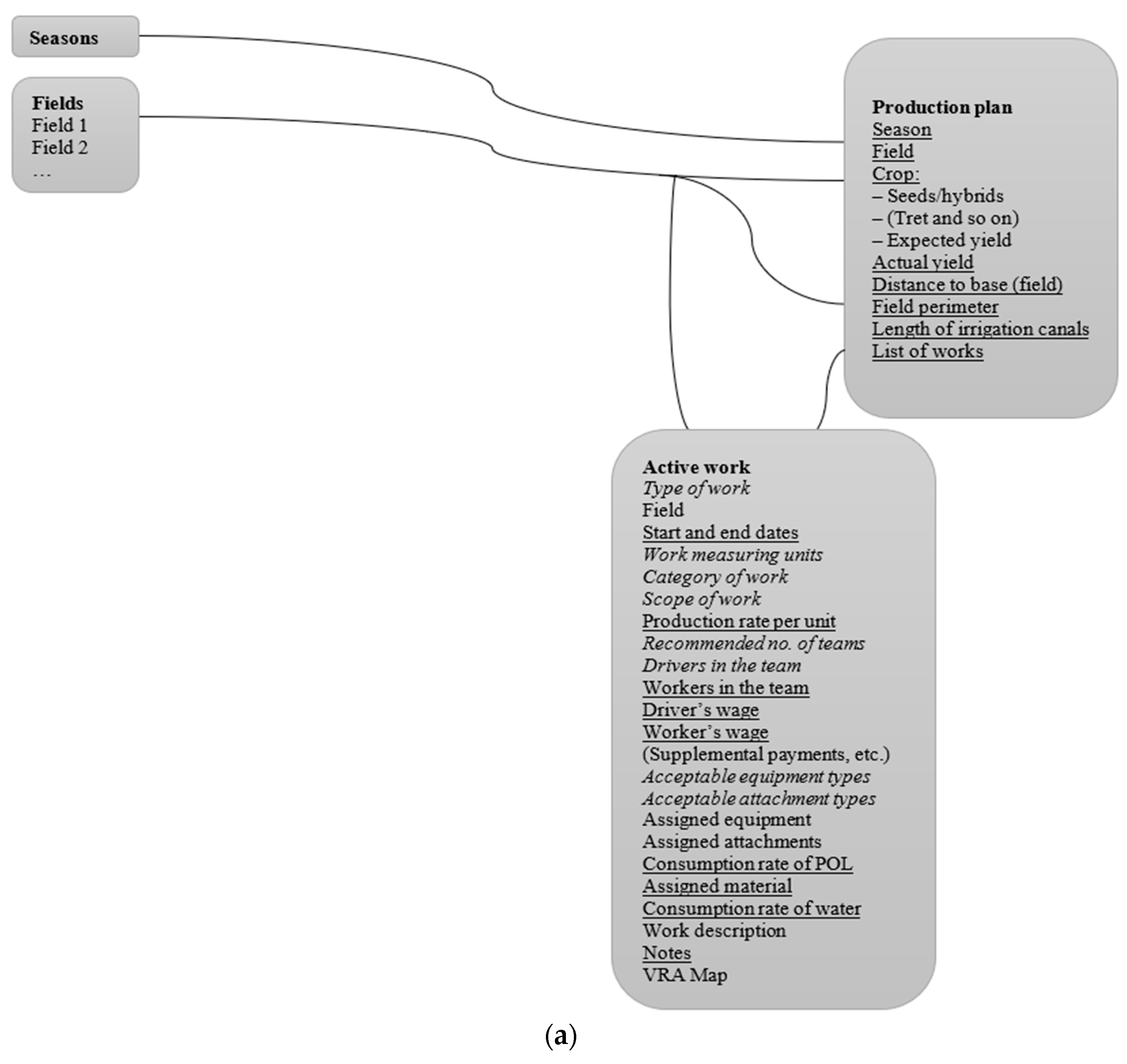
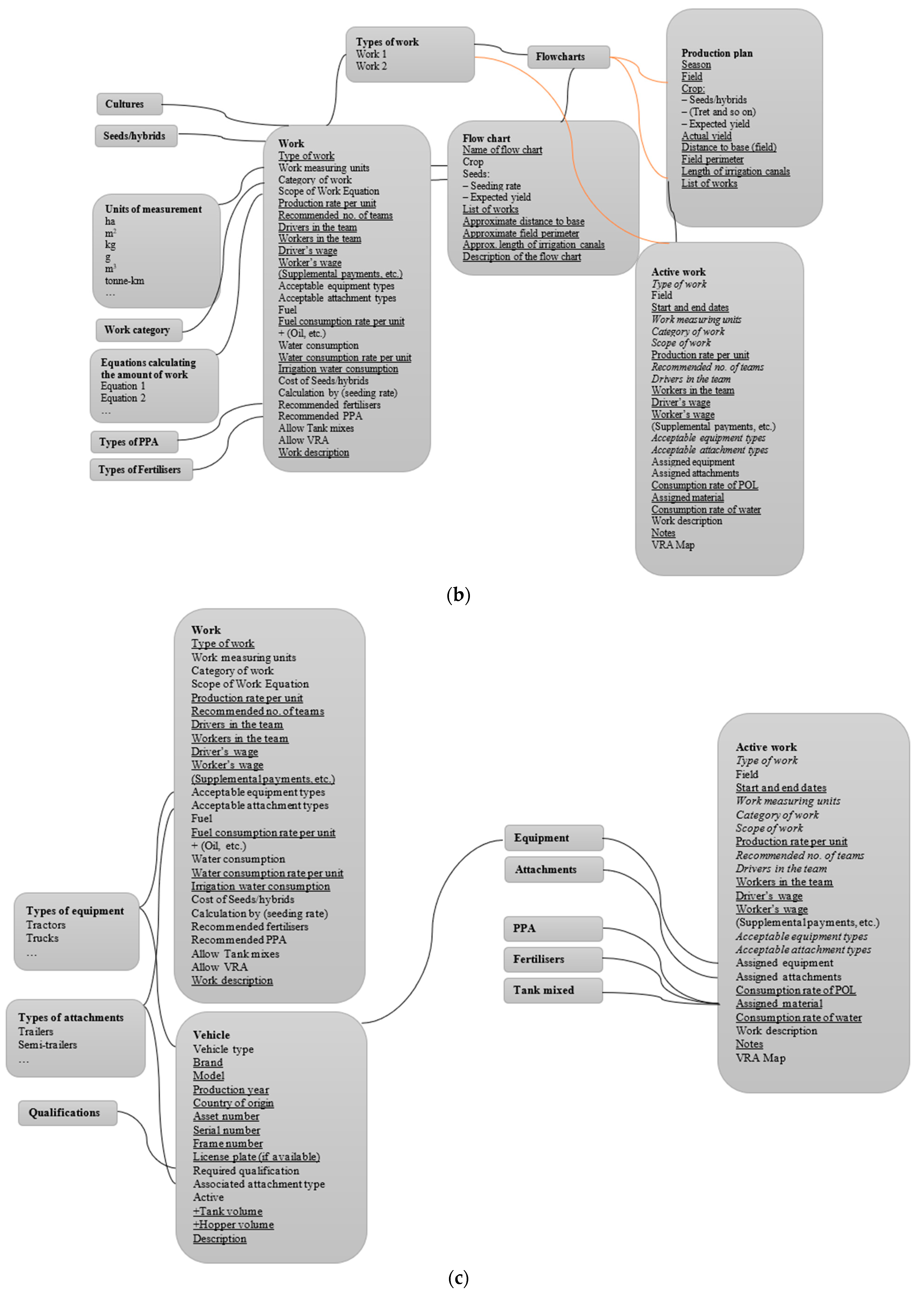
3.1. Introduction of a Digital Platform for the Development of Precision Farming

Precision farming is a system of crop productivity management based on the use of a complex of aerospace and ICT, which provides for watering and fertilisation only for those fields that need it, chemical treatment of only diseased plants, carrying out all agrotechnical measures at the optimal time, depending on specific conditions, etc. In precision farming, the most important stage is the collection of comprehensive information about the field, crops, and other kinds of resources. Modern digital information systems are an integral part of precision farming and, in many ways, their foundation [7]. Basic technologies that ensure precision farming include:
Cartographic and geoinformation systems;
Navigation systems, uncrewed aerial vehicles, information from satellites;
The Internet of Things technologies for direct collection and transmission of primary data from fields, agricultural machinery, digital weather stations and other sensors;
Resource-planning systems of all types (land, water, personnel, equipment, crops, seeds, plant protection products, warehouses, stocks, etc.);
Automatic control systems for agricultural machinery.
Despite some attempts at technological improvement, extensive agriculture still dominates in Kazakhstan, existing due to the exploitation of natural soil fertility. The consequence of low farming standards is an unprecedented depletion of soils, water and wind erosion, and a decrease in the competitiveness of both the industry and individual farms [8]. In agriculture, the introduction of digital systems objectively lags behind the industry; despite this, there is a massive introduction of computer technologies in agriculture in the United States, Europe and other countries. Information systems (IS) (software, hardware/firmware part of agricultural machinery, digital weather stations, sensors, data transmission systems) complement conventional agricultural tools and provide very valuable information on their optimal use [9,10].
The solution to such problems requires a large amount of initial data, the receipt of which is the main part of the cost of using information technologies in agriculture. A feature of the introduction of IS in agriculture is the collection of data on large areas over a significant time period. Only the relevance, accuracy and completeness of the initial data can ensure the effective use of information technologies in agriculture. Despite the success of introducing innovative precision farming technologies into agricultural production in Kazakhstan, there is still no unified digital platform that unites all the elements, provided with methodological foundations for managing the production process in the precision farming system.
A turning point in the development of crop production in Kazakhstan will be the mass introduction of precision farming technologies in the agro-industrial complex. This refers to a set of measures to manage the parameters of fertility. These include, among other things, the installation of soil sensors, the compilation of a vegetation map, satellite and aerial photography with the use of uncrewed aerial vehicles (UAVs), differentiated planting, and fertilisation as well as cartographic images of fields that help to track the state of the crop in real-time, including using the Normalised Difference Vegetation Index (NDVI) [11,12]. The management of agricultural production takes place largely under conditions of uncertainty due to the lack of reliable current and forecast data on the state of nature and the lack of knowledge about biological and physical processes that occur randomly. During the implementation of the project, software and methodological framework for the use of precision farming techniques and information technologies for managing the process of growing crops in the field were developed.

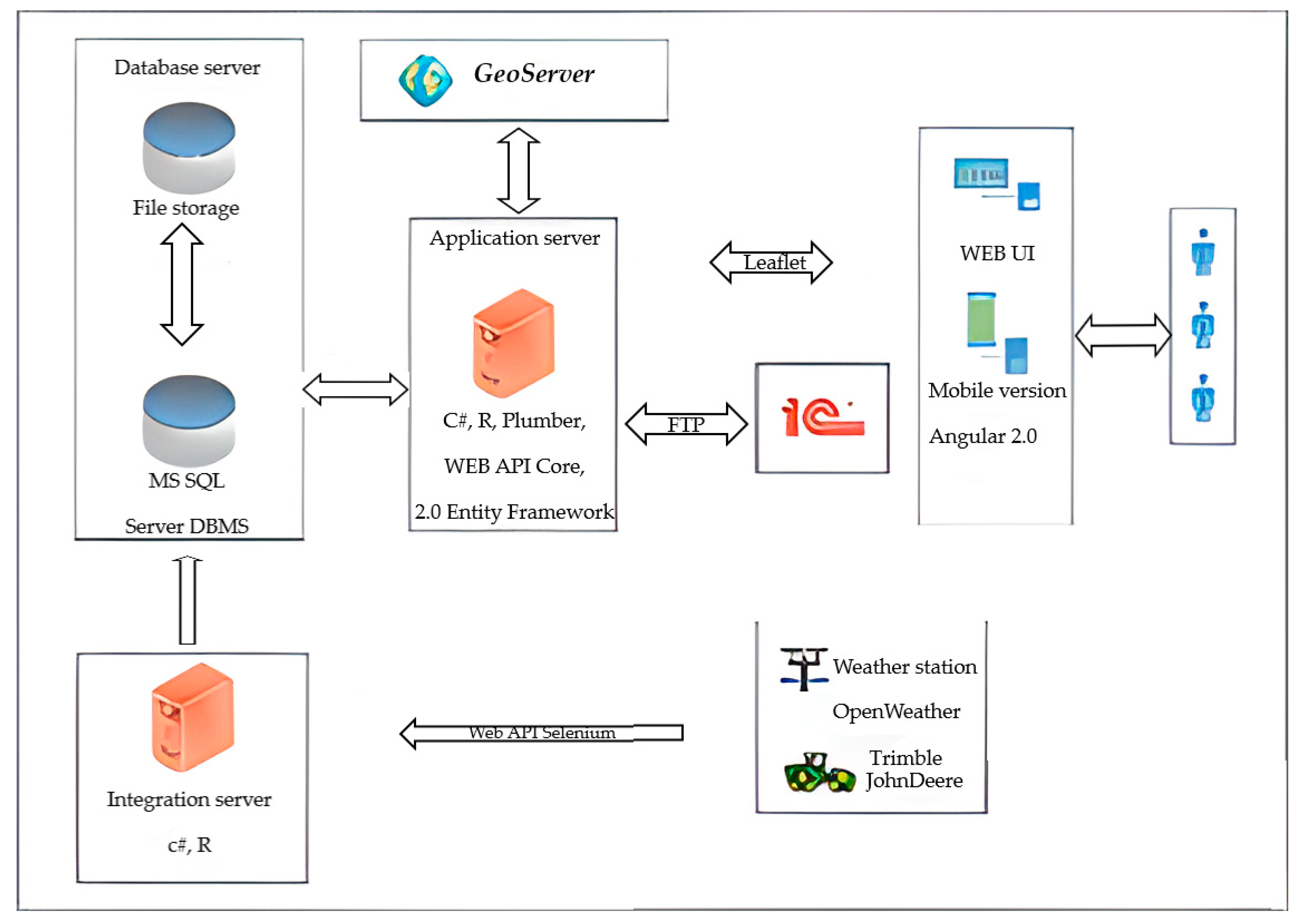
3.2. Implementation of the Farm Management Information Systems (FMIS) Project

In the management of an agro-industrial enterprise, a large place is occupied by a block of economic issues, the organisation and functioning of the economy to increase its profitability, employment, and staff development. The Farm Management Information Systems (FMIS) project facilitates the strategic, tactical, and operational planning, implementation and documentation, evaluation and optimisation of work performed in the fields or on farms.
This system allows receiving and transmitting the necessary digital data to any consumer, including state, supervisory, sanitary and epidemiological services. The system also allows receiving, storing and processing of a large array of digital data input, including meteorological data and data from the fields. The main feature and scientific originality of the developed FMIS is the integration (consolidation) of heterogeneous data from various sources. Based on this platform, various agricultural data are consolidated in a distributed repository for all branches of agricultural production [13,14,15].
Geographic information systems are one of the supporting mechanisms for data consolidation. The mechanisms implemented in the system, including integration with the geographic information system (GIS), allows for the creation and editing of digital field maps, processing of the images obtained from the UAV, and the consolidation of the information obtained in separate layers. Other data is collected using sensor arrays installed on modern, GPS-equipped tractors, combines and other equipment. Gateways for integrating data received from digital weather stations have been developed. An algorithm for reading data from various external internet sources (sites) has been developed for analysing and predicting data on raw material prices in the agricultural sector. Integration with the 1C accounting system has been completed. The following system features are implemented in the FMIS software package:
Round-the-clock system operation;
Handling exceptional situations;
Automated monitoring of user actions;
Protection of information from unauthorised access;
Distributed user access to the system;
Safeguarding information in case of accidents.
The FMIS keeps records of the state of fields, weather and spatial monitoring, management of agricultural machinery, and analysis of the interrelationships of various factors affecting crop yields. All these indicators are based on spatially distributed information. The digital cartography packages ArcGISOnline (basic free package) and QGIS (free license) were used to analyse the solution of problems in FMIS. A GIS project was launched on the basis of both software packages, and data aggregation and filling of the geoinformation data database were carried out. Integration with the ArcGIS geoinformation system and porting of the collected data to the ArcGISPro system was implemented. The ArcGIS server is located in the building of the Plant Protection Institute. The problem of a stable connection to the server of the geoinformation system for the possibility of displaying various types of digital maps was solved [16,17].
The information interaction of the ArcGIS system and the distribution of the FMIS database has been established (Figure 1). A powerful Microsoft SQL Server 2016 database management system (DBMS) was used to store and process geospatial data, which provides storage of structured and unstructured information of various types, including large files such as digital field maps. GeoServer is the reference repository of all the geospatial information of the FMIS project. Its main task is the storage and processing of geoinformation data; it handles a large number of spatially distributed heterogeneous data from a variety of sources that have been integrated (consolidated) based on GIS and digital cartography.
GeoServer is an open-source server that allows one to manage GIS data easily [18]. It provides data in accordance with the Warehouse Management System and Web Feature Service (WFS) standards. It supports all the necessary mapping services—WFS-T for modifying up-to-date data, the Geographic Markup Language (GML), the Keyhole Markup Language (KML) and many other formats used in geoinformation systems. GeoServer works as a bridge between FMIS user interfaces and map data.
Access from FMIS was possible by using a special application service. Since all cartographic information is stored on the GeoServer, the application server’s job is to organise access to the GeoServer and read the necessary cartographic information from it. Such access is organised using the built-in REST API, where the data sets are managed in real-time. The FMIS uses REST-wrapper APIs, such as GeosAPI and PlumbR, to transfer data through the pipeline [28,29,30]. The system of application of fertilisers is the most important link in the application of FMIS, as it is one of the most significant controlling factors in the formation of crop yields. The efficiency of fertilisers will be higher if all complex technologies are used in a GIS as part of the point analysis of digital cartography. The use of fertilisers is limited primarily due to their high cost, and therefore the system of applying fertilisers requires much attention. New digital technologies provide a good opportunity to change the agrotechnical survey of cultivated land. Automation of mapping and sampling, GIS technologies and positioning systems and various sensors can significantly improve the system of soil and field monitoring.
The system implements the capabilities of storing and processing meteorological data that can be received from automatic weather stations. It is possible to integrate with any type of weather station primarily using the API software service. The information transmitted from the weather stations is stored on the FMISAGROPARK server, providing the agronomist with access at any time of the day from anywhere in the world. Based on the data analysis, the company’s specialist makes the necessary adjustments to the implementation of agrotechnical measures, which include, for example, irrigation or pest control of plants. Data from weather stations help to make a decision for high-quality planning of various works on the field, which directly depend on weather conditions, and also allows for creating a database and a history of each individual element. For example, information on temperature conditions and precipitation contributes to the selection of crop varieties in crop rotation.
Therefore, in order to develop a reasonable set of management measures, the FMIS system provides the most complete and integrated information for agronomists, forepersons, and farm managers. The developed interface, including a mobile application, allows performing the entire range of basic operations for digital management of processes in crop production required for FMIS, primarily the visualisation of various digital field maps. Such an interface performs all the actions necessary for managing production (technological) operations. The information display is complete and sufficient for operational analysis and management of all work (Figure 2).
A feature of the system architecture is the need to extract heterogeneous data from many sources presented in various formats, which include the following data types:
Digital maps of territories using high-resolution raster data (up to 2 cm/px), which are highly demanded due to the disk space and read/write rate;
Field attributes such as contours, profiles, field history, soil mineral composition, events and dates of work;
Climate data (data obtained from one test weather station);
Machinery and equipment (register of agricultural machinery);
Events and work in the fields, etc.;
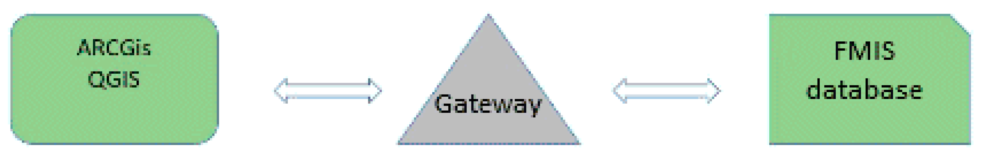
Geoinformation data from the ArcGIS server;
Data received from JohnDeere sensors;
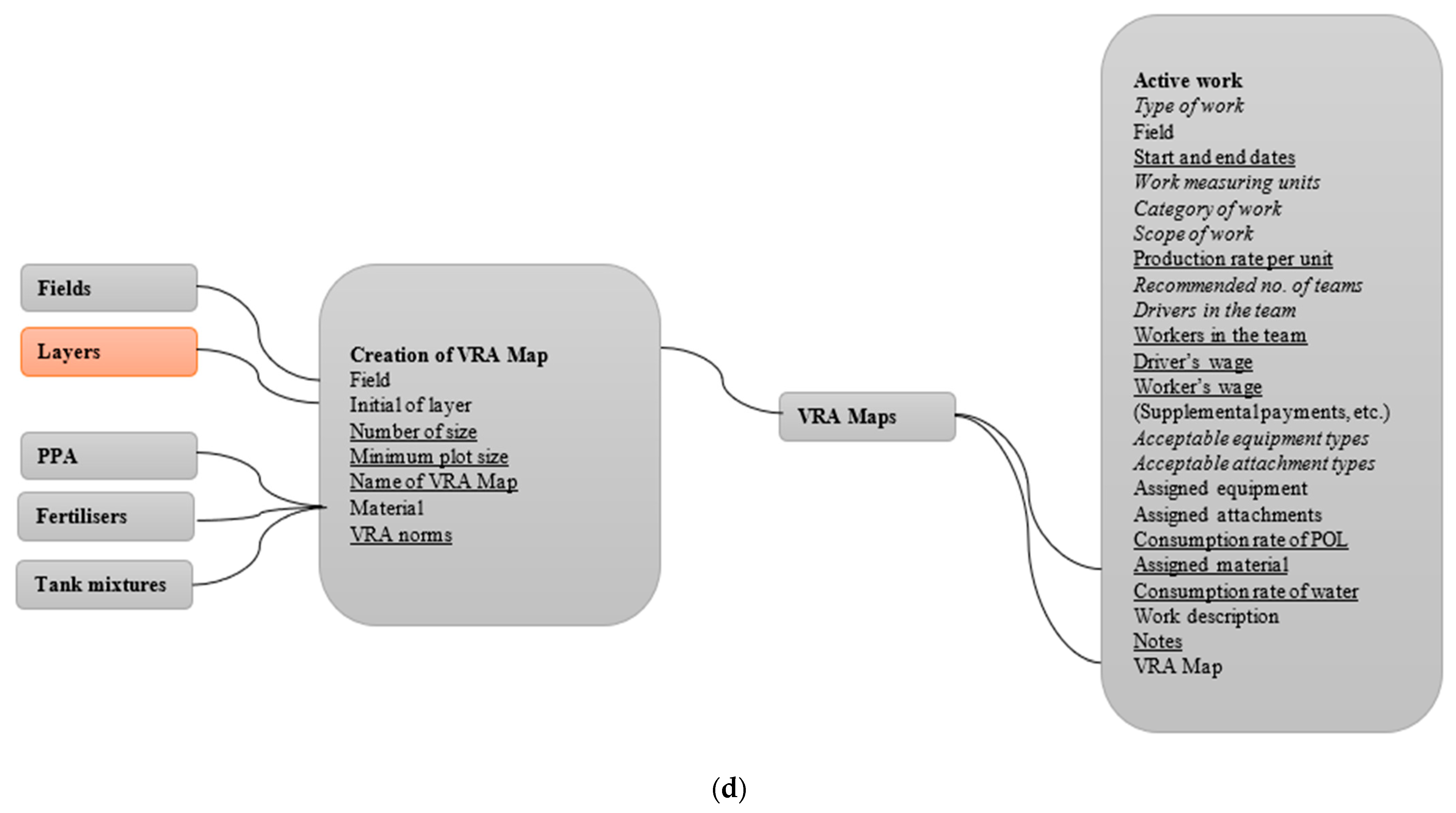
Other data on agricultural management (Figure 3).
Figure 3 shows the structure of the digital platform in the form of a detailed diagram reflecting the main modules of the FMIS. In addition to integration through the database, all modules of the system have other interaction mechanisms based on functional (production) interaction.

4. Discussion

According to V. Galaz et al. [25], the use of precision in combination with modern robotics and crop production technology would allow for avoiding negative impacts on plants and their habitat through scientifically based differentiated control of the production process of agricultural crops using all means for obtaining and processing measurement information in real-time. This approach will help bring agriculture to a level where it can compete with foreign producers as quickly as possible, using the tools of the World Trade Organization.
In addition, a comparison of complex agricultural technologies with other highly mechanised technologies shows that in addition to high yields, agricultural technologies improve the quality of products and sharply reduce the use of mineral fertilisers and plant protection products. T. Daum [23] considers that they allow for the reduction or elimination of environmental damage to agricultural production and obtain environmentally friendly products.
S. Neethirajan and B. Kemp [27] believe that the use of innovative technologies in agriculture is no longer a matter of choice, but a necessity, one of the main elements of this technology is precision farming. According to the analysis of the situation in the agricultural sector of the economy of Kazakhstan, one of the main reasons for the low profitability of this sector is the lack of development and implementation of modern agricultural technologies and processing of agricultural products [31,32,33,34].
Y. Chen et al. [29] consider that the intensification of production is impossible without the use and introduction of innovative technologies, modern scientific achievements, digital solutions, and international exchange. The analysis of the situation in the agricultural sector of the economy of Kazakhstan shows that one of the main reasons for the low profitability of this sector is the low level of development and introduction of modern agricultural technologies and technologies for processing agricultural products.

5. Conclusions

It has been established that modern digital information systems are an integral part of precision farming. The introduction of a digital platform for practical implementation at an agro-industrial enterprise is of great practical importance for the development of precision farming. The FMIS performs all the necessary operations with all types of production and resource bases. This module of production activity includes the following sections of FMIS, reflecting the production nature and management of the enterprise’s resources: production plans, technological maps, work, personnel, warehouse, and notes. The architecture of a distributed database for storing large data sets has been developed. The module of automatic generation of technological production maps, based on the list of plants, climatic-geographical conditions, soil sites, machinery fleet, and other criteria, has been developed and passed trial operation. Modules for drawing up production plans and technological maps have been developed. The transfer of technologies for analysing the economic efficiency of production was carried out, a module for generating reports was developed, and partial integration with 1C accounting was carried out. A subsystem for monitoring and controlling agricultural machinery, as well as systems for parallel driving, accounting for material costs and creating and controlling route tasks for equipment, has been developed. The transfer of technologies for parallel driving, autopiloting, auto-steering, and control of aggregates was performed.

Implications and Limitations

The scientific novelty of this project is the simultaneous and comprehensive implementation of a whole set of new digital technologies in a single package. Since the FMIS takes full advantage of new technologies for integrating the most diverse data and information sources, including digital data from sensors, the limitations of the research are that the problem of using parallel driving systems has not been solved. Compared with the usual control of a machine-tractor unit, the use of parallel driving systems when performing technological operations allows for eliminating repeated processing of adjacent passages (overlaps) and skipping untreated areas, thereby increasing productivity and comfort of work, reducing driver fatigue and fuel consumption and technological materials, and allowing workers to carry out work in any visibility condition, including at night. Improving the existing navigation and location accuracy of equipment will also determine the prospects for the development of precision farming systems.

Author Contributions

K.R.M.: Conceptualisation, data curation, formal analysis, writing—original draft; N.P.C. and A.V.K.: investigation; Z.B.D.: methodology, resources, validation, writing—original draft, writing—review and editing; M.T.: project administration, visualisation, writing—original draft, writing—review and editing, supervision. All authors have read and agreed to the published version of the manuscript.

Funding

This research received no external funding.

Institutional Review Board Statement

Not applicable.

Informed Consent Statement

Not applicable.

Data Availability Statement

The data supporting the findings of this study are available upon request from the corresponding author.

Conflicts of Interest

The authors declare no conflict of interest.

References

  1. Strategic Development Plan of the Republic of Kazakhstan Until 2025. Available online: https://primeminister.kz/ru/documents/gosprograms/stratplan-2025 (accessed on 12 September 2022).
  2. Zhang, Q.; Yang, L.T.; Chen, Z.; Li, P. A survey on deep learning for big data. Inf. Fusion 2018, 42, 146–157. [Google Scholar] [CrossRef]
  3. Bhatnagar, R. Machine learning and big data processing: A technological perspective and review. Adv. Int. Sys. Comp. 2018, 723, 468–478. [Google Scholar]
  4. Liakos, K.; Busato, P.; Moshou, D.; Pearson, S.; Bochtis, D. Machine learning in agriculture: A review. Sensors 2018, 18, 2674. [Google Scholar] [CrossRef] [Green Version]
  5. Li, Y.; Chen, G.; Wang, D. Research and application of 3D visualization plug-in integration with arcgis. IFIP Adv. Inf. Commun. Tech. 2019, 546, 21–30. [Google Scholar]
  6. Bychkova, S.; Makarova, N.; Zhidkova, E. Measurement of information in the subsystem of internal control of the controlling system of organizations of the agro-industrial complex. Entrepr. Sustain. Issues 2018, 6, 35–43. [Google Scholar] [CrossRef]
  7. Patil, S.; Chavan, V.G.; Patil, P. Social innovation through precision farming: An iot based precision farming system for examining and improving soil fertility and soil health. Int. J. Innov. Tech. Explor. Eng. 2019, 8, 2877–2881. [Google Scholar] [CrossRef]
  8. What Is AgroparkOntustik. Available online: https://www.agropark.kz/ (accessed on 12 September 2022).
  9. Pedersen, S.M.; Medici, M.; Anken, T.; Tsiropoulos, Z.; Fountas, S. Financial and Environmental Performance of Integrated Precision Farming Systems; Wageningen Academic Publishers: Wageningen, The Netherlands, 2019. [Google Scholar]
  10. Cullu, M.A.; Teke, M.; Mutlu, N.; Bilgili, A.V.; Bozgeyik, F. Integration and Importance of Soil Mapping Results in the Precision Agriculture; Institute of Electrical and Electronics Engineers Inc.: Piscataway, NJ, USA, 2019. [Google Scholar]
  11. Berger, A.; Ettlin, G.; Quincke, C.; Rodríguez-Bocca, P. Predicting the Normalized Difference Vegetation Index (NDVI) by training a crop growth model with historical data. Comp. Electron. Agricult. 2019, 161, 305–311. [Google Scholar] [CrossRef]
  12. Bujalský, L.; Jirka, V.; Zemek, F.; Frouz, J. Relationships between the normalised difference vegetation index and temperature fluctuations in post-mining sites. Int. J. Min. Reclam. Env. 2018, 32, 254–263. [Google Scholar] [CrossRef]
  13. Nugawela, S.; Sedera, D. Analysis of farm management information systems: Opportunities and pathways for future value. In Proceedings of the Pacific Asia Conference on Information Systems, Dubai, United Arab Emirates, 20–24 June 2020. [Google Scholar]
  14. Atlanta: Association for Information Systems. Available online: https://aisel.aisnet.org/pacis2020/78/ (accessed on 12 September 2022).
  15. Tummers, J.; Kassahun, A.; Tekinerdogan, B. Obstacles and features of Farm Management Information Systems: A systematic literature review. Comp. Electron. Agricult. 2019, 157, 189–204. [Google Scholar] [CrossRef]
  16. He, P.; Chang, H.; Gao, H.; Wang, Z. Research on cattle farm management information system. In Proceedings of the 2017 6th International Conference on Computer Science and Network Technology (ICCSNT), Dalian, China, 21–22 October 2017; Volume 1, pp. 508–510. [Google Scholar]
  17. Lv, Z. Construction of soil environment information management platform based on ArcGIS. IOP Conf. Ser. Earth Env. Sci. 2020, 546, 032039. [Google Scholar] [CrossRef]
  18. Mogili, U.M.R.; Deepak, B. Review on application of drone systems in precision agriculture. Pro. Comp. Sci. 2018, 133, 502–509. [Google Scholar] [CrossRef]
  19. Tsoraeva, E.; Mezhyan, S.; Kataeva, M.; Hugaeva, L.; Rogova, T. GIS technologies used in zoning agricultural land for optimizing regional land use. E3S Web Conf. 2020, 224, 03001. [Google Scholar] [CrossRef]
  20. Birner, R.; Daum, T.; Pray, C. Who drives the digital revolution in agriculture? A review of supply-side trends, players and challenges. Appl. Econ. Persp. Policy 2021, 43, 1260–1285. [Google Scholar] [CrossRef]
  21. Carolan, M. Automated agrifood futures: Robotics, labor and the distributive politics of digital agriculture. J. Peasant Stud. 2020, 47, 184–207. [Google Scholar] [CrossRef]
  22. Clapp, J.; Ruder, S.-L. Precision technologies for agriculture: Digital farming, gene-edited crops, and the politics of sustainability. Glob. Env. Polit. 2020, 20, 49–69. [Google Scholar] [CrossRef]
  23. Daum, T. Farm robots: Ecological utopia or dystopia? Trends Ecol. Evolut. 2021, 36, 774–777. [Google Scholar] [CrossRef]
  24. Ehlers, M.-H.; Huber, R.; Finger, R. Agricultural policy in the era of digitalisation. Food Policy 2021, 100, 102019. [Google Scholar] [CrossRef]
  25. Galaz, V.; Centeno, M.A.; Callahan, P.W.; Causevic, A.; Patterson, T.; Brass, I.; Baum, S.; Levy, K. Artificial intelligence, systemic risks, and sustainability. Technol. Soc. 2021, 67, 101741. [Google Scholar] [CrossRef]
  26. Akbar, M.O.; Shahbaz Khan, M.S.; Ali, M.J.; Hussain, A.; Qaiser, G.; Pasha, M.; Pasha, U.; Akhtar, N. IoT for development of smart dairy farming. J. Food Qual. 2020, 1, 4242805. [Google Scholar] [CrossRef]
  27. García, R.; Aguilar, J.; Toro, M.; Pinto, A.; Rodríguez, P. A systematic literature review on the use of machine learning in precision livestock farming. Comp. Electr. Agricult. 2020, 179, 105826. [Google Scholar] [CrossRef]
  28. Neethirajan, S.; Kemp, B. Digital livestock farming. Sens. Bio-Sens. Res. 2021, 32, 100408. [Google Scholar] [CrossRef]
  29. Abdirad, M.; Krishnan, K.; Gupta, D. A two-stage metaheuristic algorithm for the dynamic vehicle routing problem in Industry 4.0 approach. J. Manag. Anal. 2021, 8, 69–83. [Google Scholar] [CrossRef]
  30. Chen, Y.; Li, Y.; Li, C. Electronic agriculture, blockchain and digital agricultural democratization: Origin, theory and application. J. Clean. Product. 2020, 268, 122071. [Google Scholar] [CrossRef]
  31. Iaksch, J.; Fernandes, E.; Borsato, M. Digitalization and Big data in smart farming–A review. J. Manag. Anal. 2021, 8, 333–349. [Google Scholar] [CrossRef]
  32. GeoEye-1 Satellite Sensor (0.46 m). 2020. Available online: https://www.satimagingcorp.com/satellite-sensors/geoeye-1/ (accessed on 12 September 2022).
  33. Lalak, M.; Dobek, M.; Ciećko, A. The analysis of the accuracy of digital terrain model (Dtm) obtained from high resolution geoeye-1 satellite imagery. In Proceedings of the 18th International Multidisciplinary Scientific GeoConference SGEM2018, Albena, Bulgaria, 2–8 July 2018; Volume 18, pp. 191–198. [Google Scholar]
  34. Nasalski, Z. Determinants of agricultural farm participation in regional economic systems. Entrepr. Sustain. Issues 2021, 9, 374–384. [Google Scholar] [CrossRef]
Figure 1. Interaction of the database with the geoinformation system. Source: created by authors.
Sustainability 14 14802 g001
Figure 2. General architecture of the system. Source: created by authors.
Sustainability 14 14802 g002
Figure 3. Digital platform structure. Source: created by authors. (a) Part 1; (b) Part 2; (c) Part 3; (d) Part 4.
Sustainability 14 14802 g003aSustainability 14 14802 g003bSustainability 14 14802 g003c
Publisher’s Note: MDPI stays neutral with regard to jurisdictional claims in published maps and institutional affiliations.

