
Sustainable Complete Streets Design Criteria and Case Study in Naples, Italy
 ,
, 

Abstract
:1. Introduction
2. Literature Review
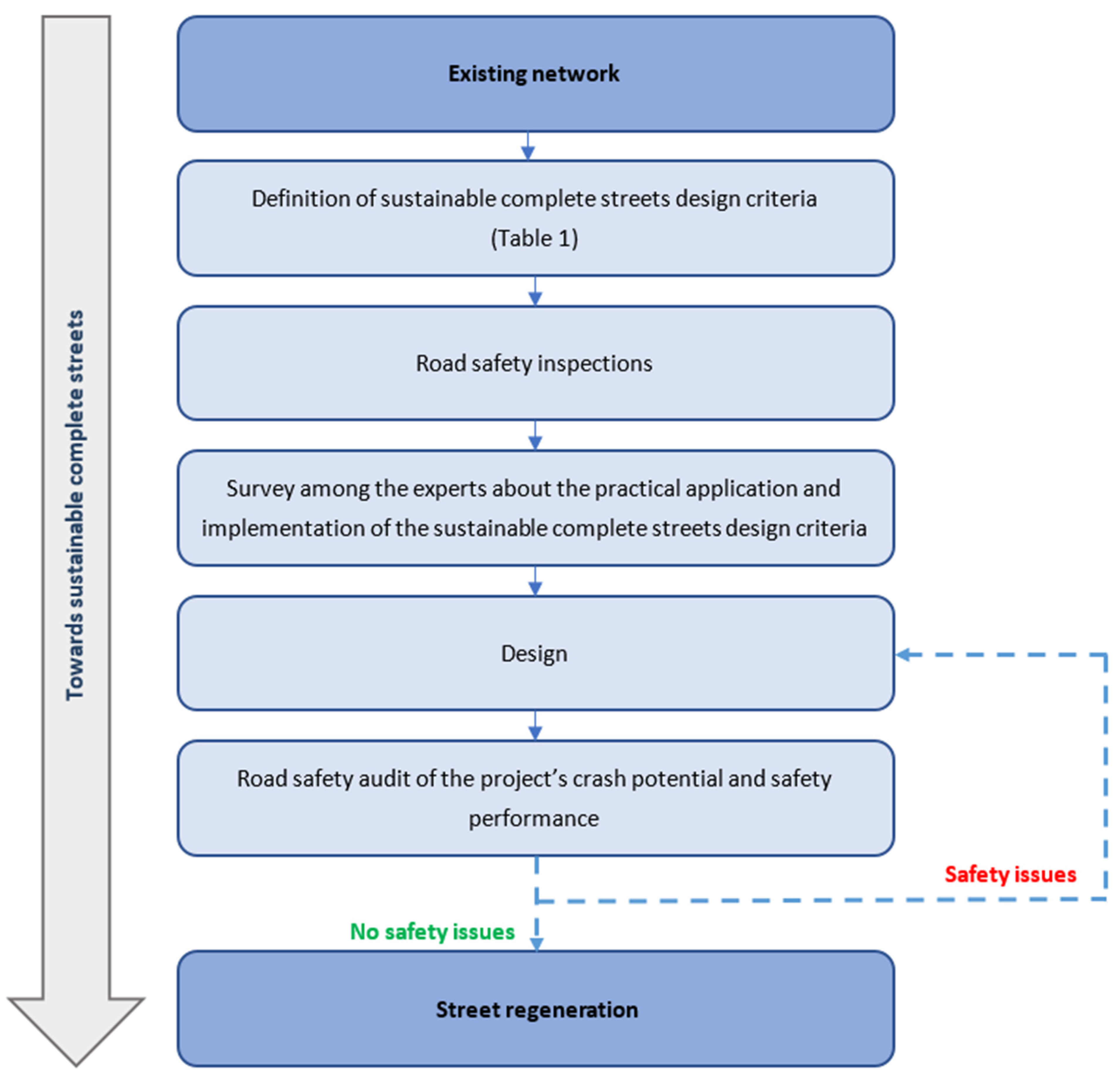
3. Methodology
3.1. General Issues
- Reducing traffic crashes and injuries, of both motorized and vulnerable road users;
- Reducing motorized traffic volume and speed;
- Increasing pedestrian, cyclist, and public transport traffic volume;
- Improving the quality of the urban landscape space, for example, its aesthetics and functional ambience;
- Recovering the urban character lost in a historical evolution due to a lack of conscious, coordinated urban planning;
- Creating a homogeneous road environment with regards to the choice of materials, colours, lighting, and treatment of green spaces;
- Increasing ‘green space’ opportunities for pedestrians and cyclists to stop, shop, and socialize;
- Reducing non-renewable energy use and its associated air pollution emissions;
- Reducing nuisances due to traffic noise and urban heat island effects.
3.2. Aesthetics
3.3. Environment
3.4. Liveability
- Ambience, i.e., the conditions of usability, comfort and safety of the public outdoor space system, including its quantity and quality of green amenities; its environmental and ecological function; and its coherent configuration;
- Function, highlighting the added value of high environmental performance in terms of efficiency, functionality, maintenance, durability and recyclability, including a reduction in energy consumption at the urban and building scale; reductions in air, water, noise and visual pollution; and the mitigation of impacts generated by infrastructure systems.
3.5. Safety
3.5.1. Road Safety Inspection
3.5.2. Road Safety Audits
- Standards are often a minimum requirement and combining a series of minimums can leave no room for error, either on the part of the designer, the builder or the final users;
- Some situations require specific expert judgements, which might not be covered by the standards;
- Individual road elements, designed to standard, may be quite safe in isolation but may be unsafe when combined with other standard elements;
- Driver errors, which contribute to 93% of all crashes [49], are bound to happen.
3.5.3. Smarter Growth Neighbourhood Design
- Traffic calming to lower speeds and short-cutting on local streets, and improve ped/bike safety;
- Continuous off-road ped/bike paths, such that biking across a neighbourhood is faster than driving;
- Fewer road lanes of narrower width, with lower speed limits to address the crossing distance and safety;
- Comprehensive bicycle and pedestrian route networks in accord with active travel demand and desire lines, integrated with compact, connected, and coordinated mixed land uses;
- Keeping major mobility roads to perimeter one-way couplets containing service commercial blocks and controlled by roundabouts to reduce the crossing risk and speeds;
- Interspersed public, open, green, restorative spaces throughout, such that no dwelling is longer than a one-minute walk away from public open space, with a major central, car-free piazza that promotes both local and community-wide social interaction;
- Convenient, affordable, and accessible, high-capacity public transit connecting this neighbourhood with major civic destinations.
3.5.4. Pedestrian Crosswalks
3.5.5. Pedestrian Accessibility
- The presence and slope of curb ramps (e.g., crosswalks without ramps or with ramps with an excessive grade are inaccessible for wheelchairs and baby carriages);
- The height of the curbs separating sidewalks from roads (e.g., an excessive height poses significant problems of accessibility—falls and trips—to older people moving between parking spaces and the sidewalk);
- Rumble-strips and tactile-strips for visually-impaired pedestrians (e.g., ramps without preceding ‘warning’ strips are a significant hazard for blind people);
- The accessibility of median breaks (e.g., inaccessible breaks make a refuge ineffective).
3.5.6. Cycle Routes
3.5.7. Sight Distance
3.5.8. Traffic Control Devices
- Greater daytime visibility;
- Greater night-time visibility;
- Greater visibility in the presence of light pollution (e.g., fog);
- Optimum angularity;
- Excellent visibility at wide entrance and observation angles;
- Greater visibility in critical conditions, such as in rain, snow, cloudy weather, at dawn, and at dusk.
3.5.9. Lighting
4. Case Study
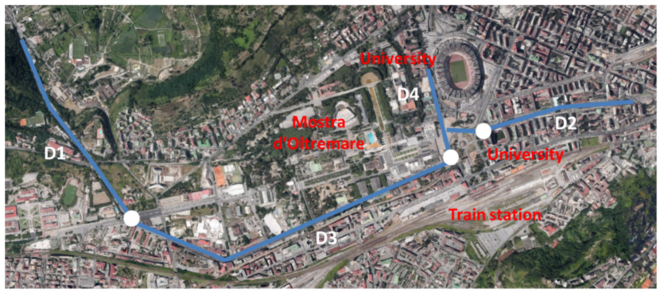
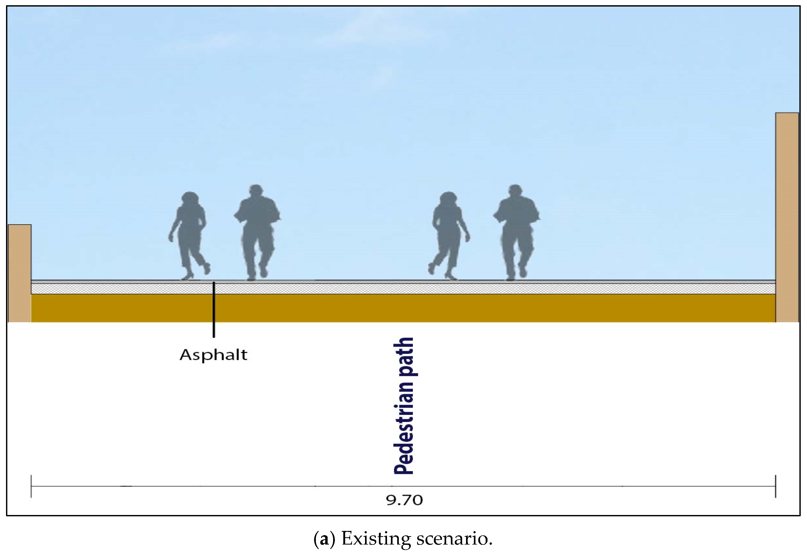
4.1. Overview
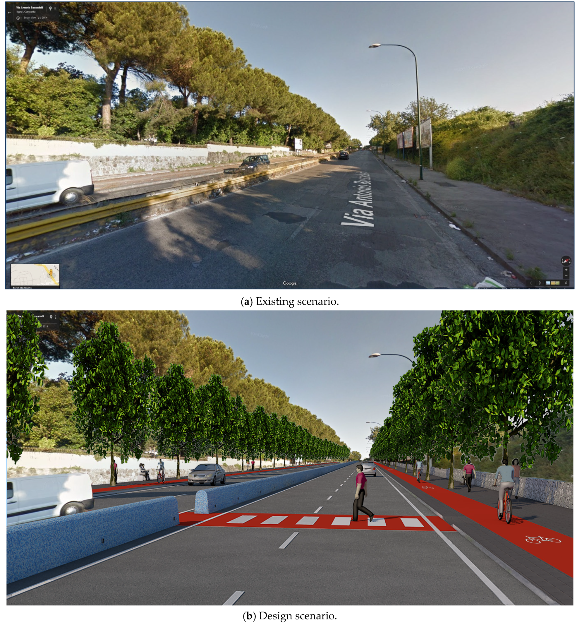
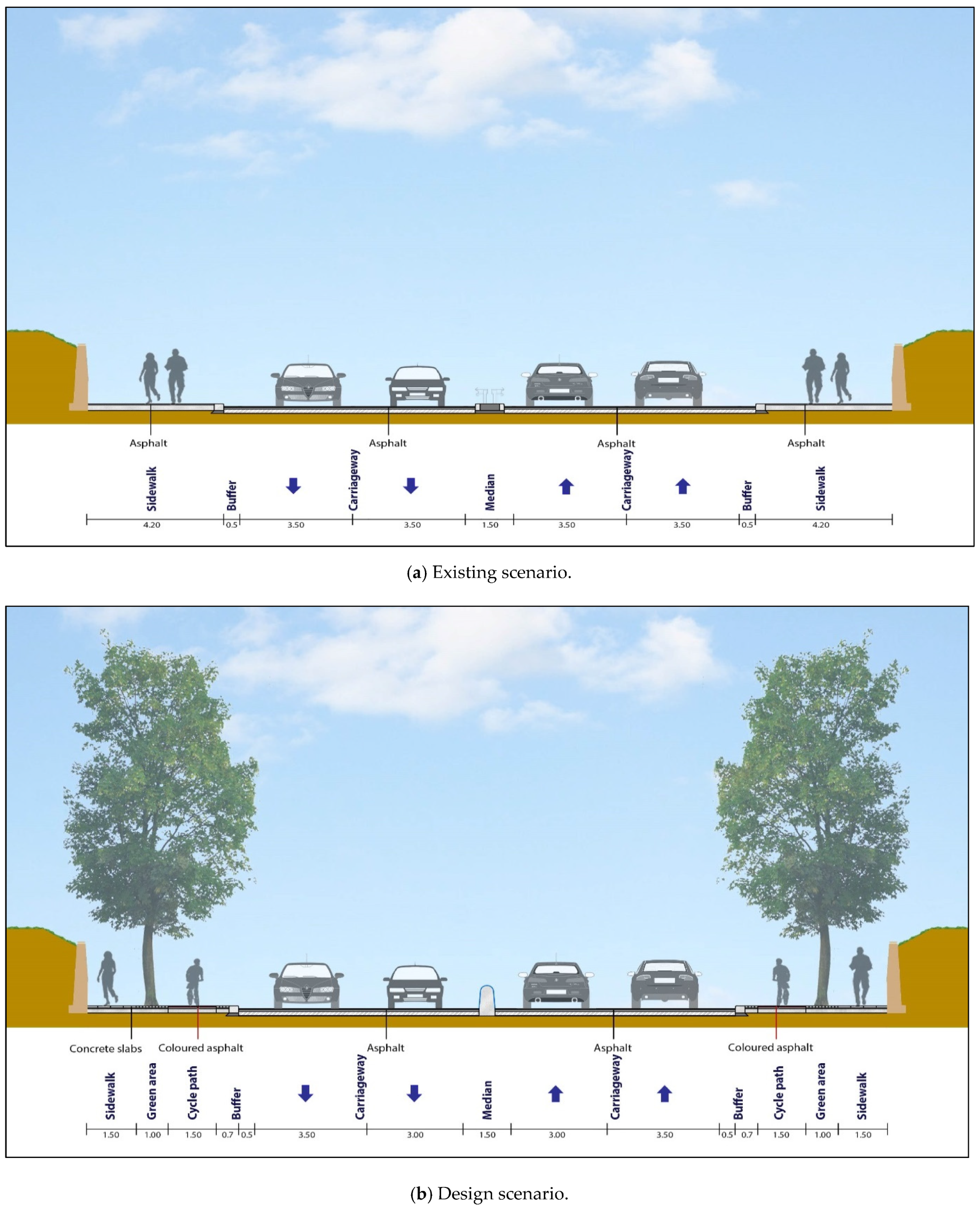
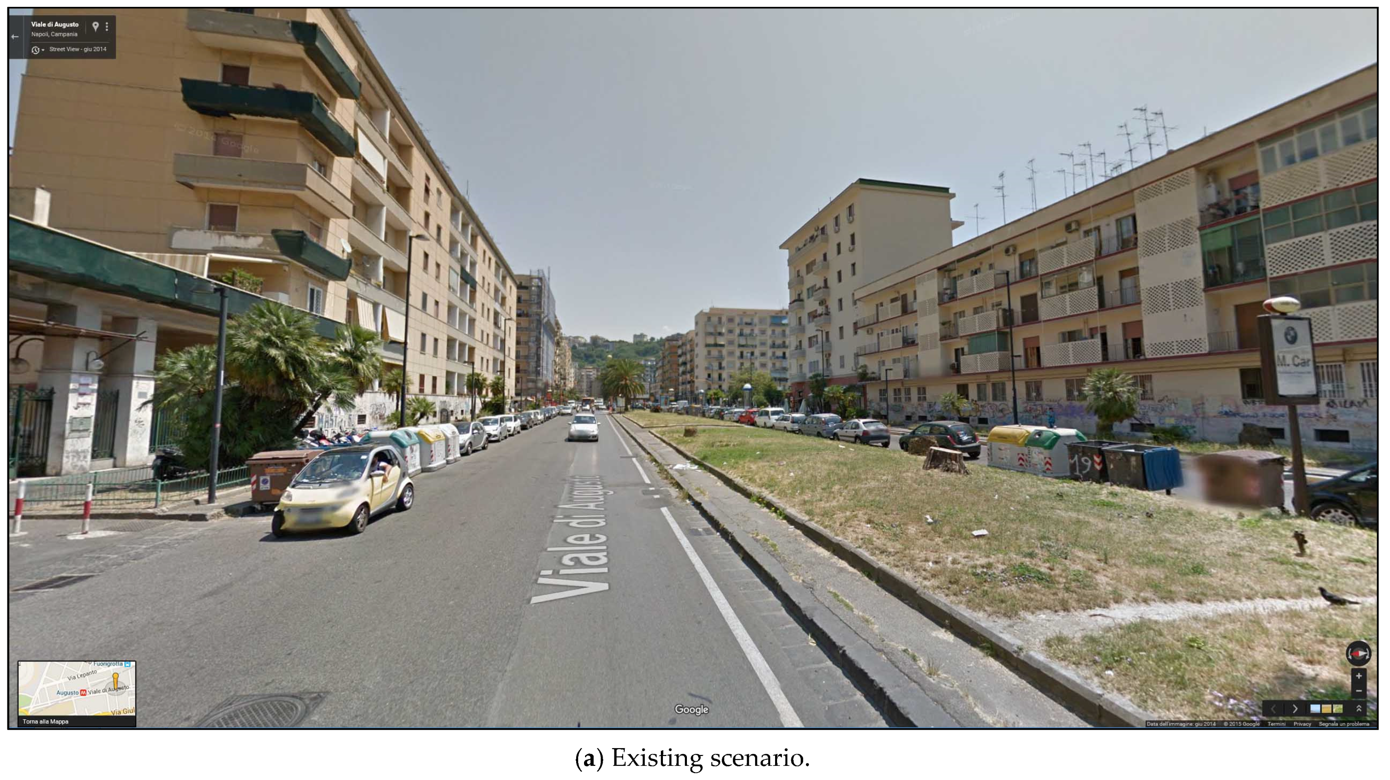
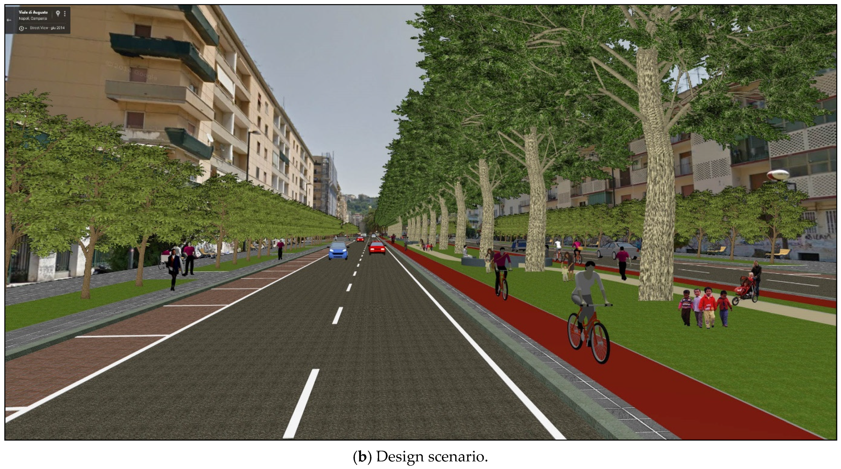
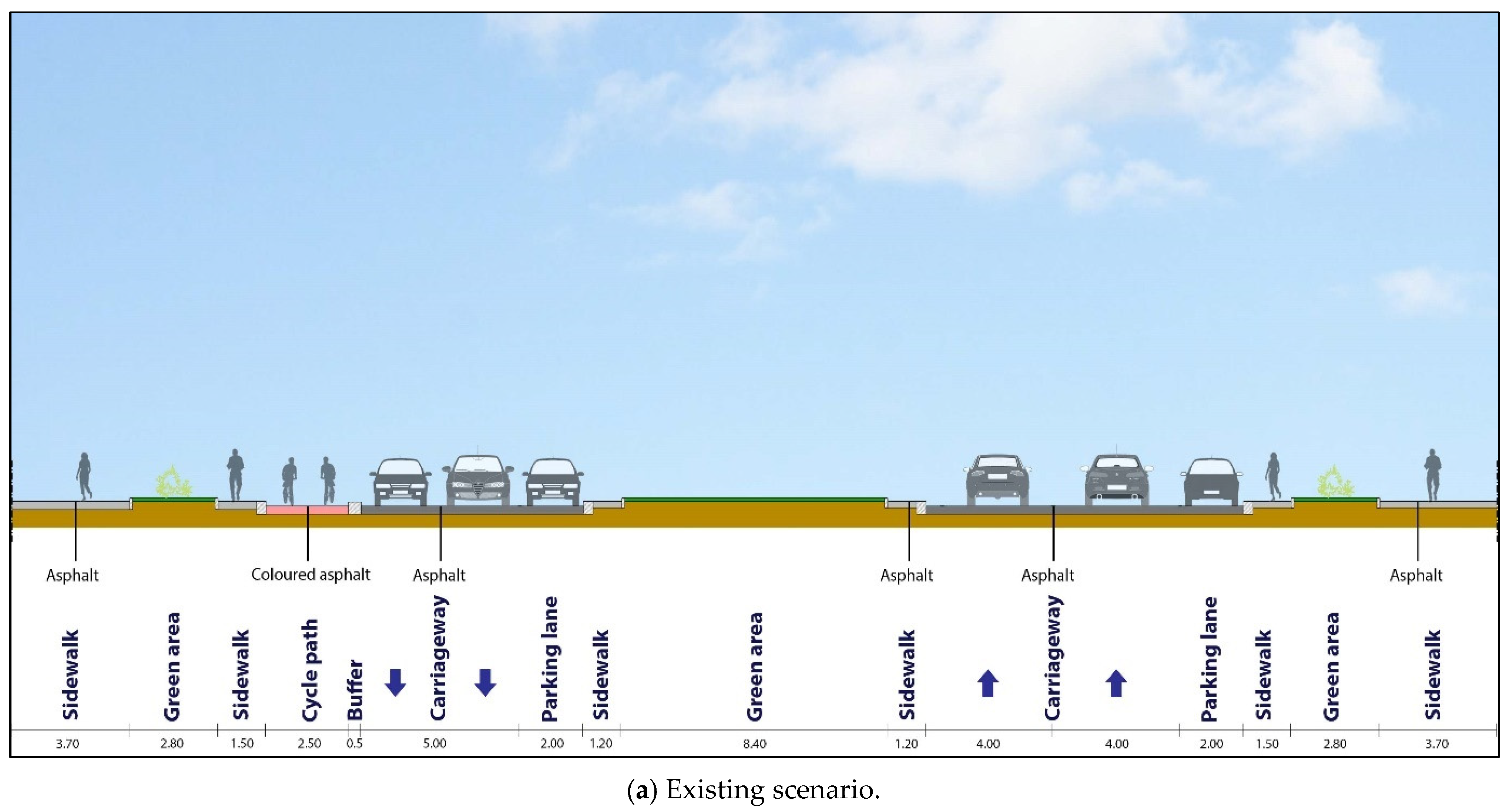
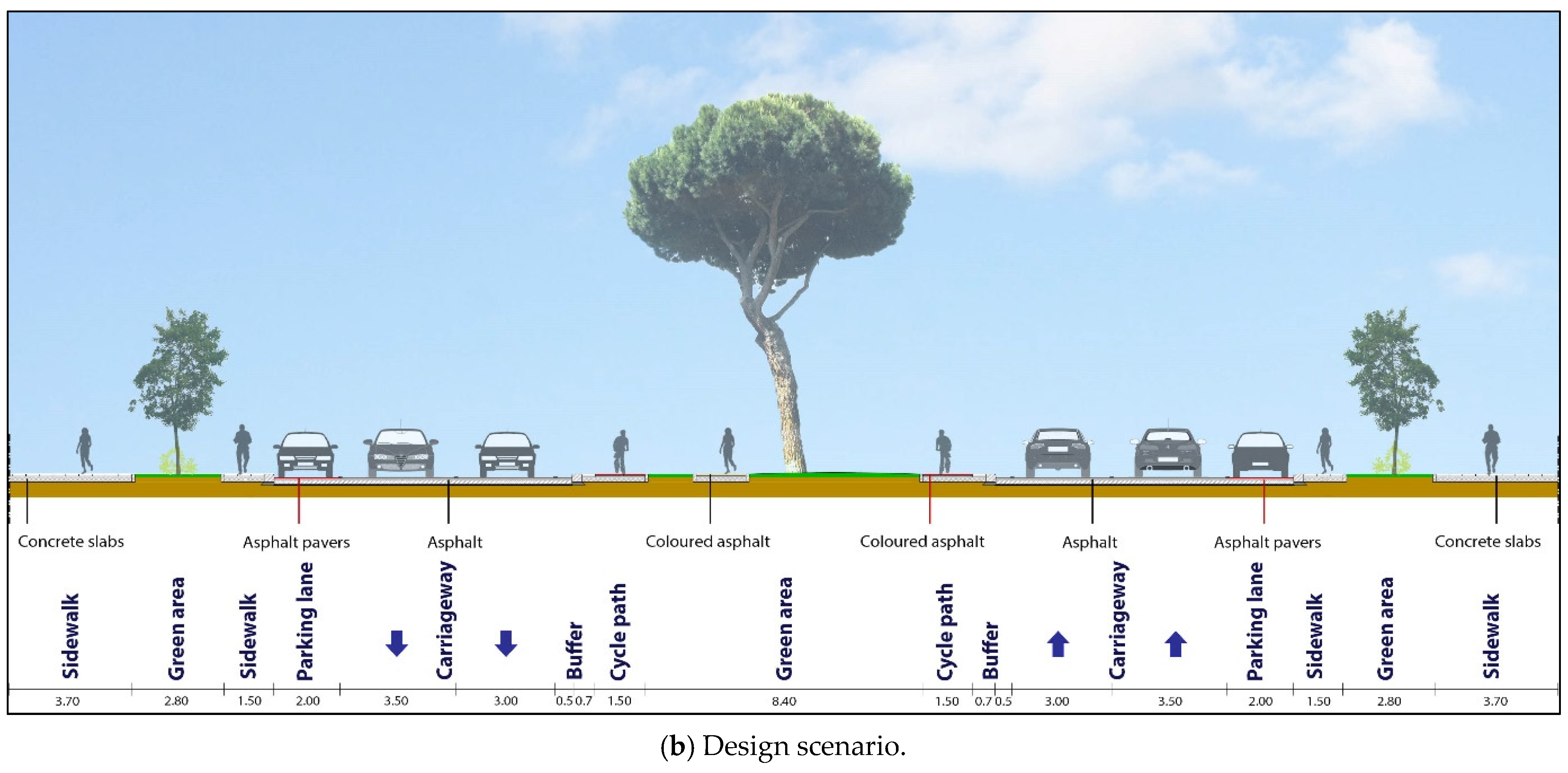
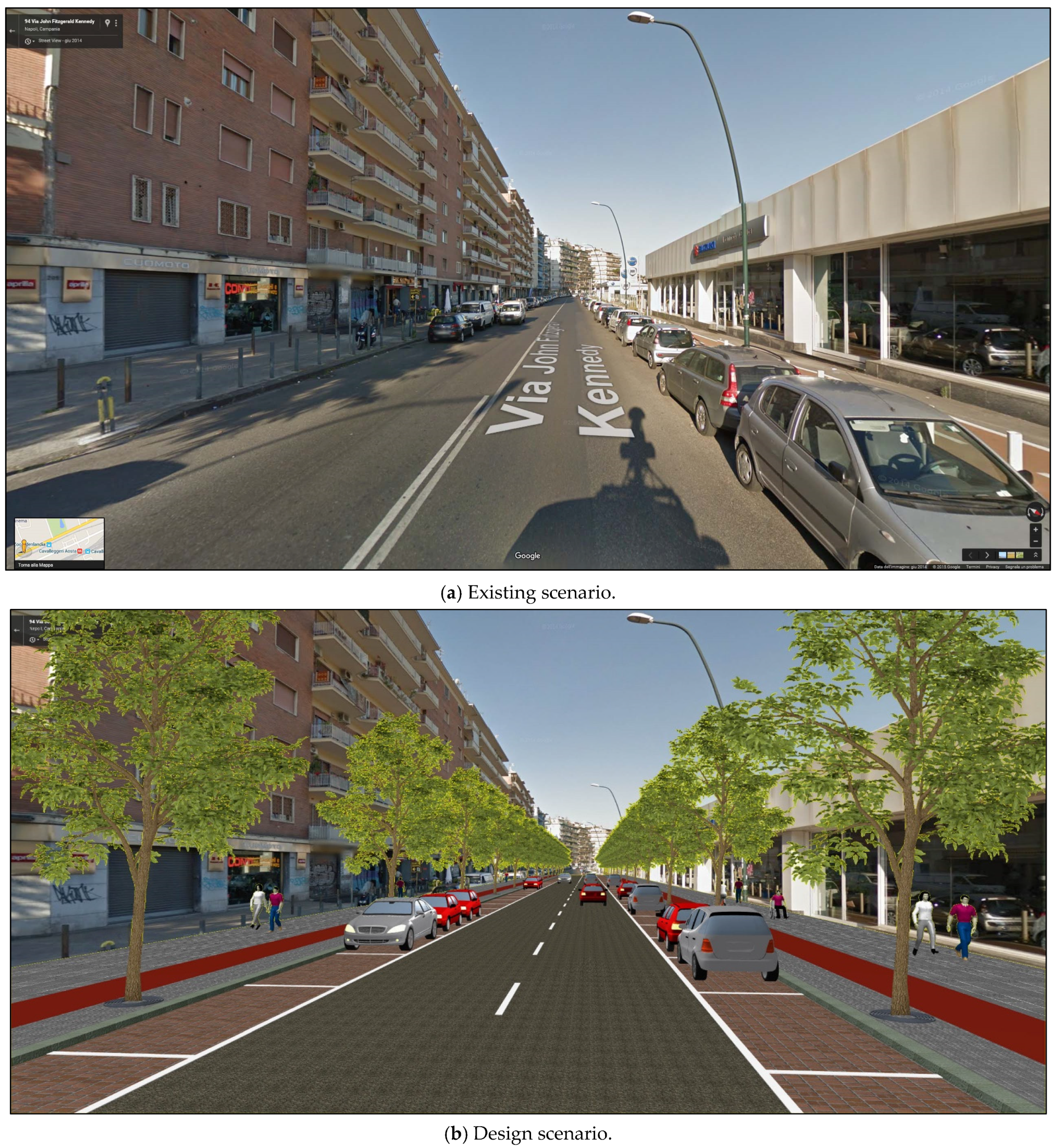
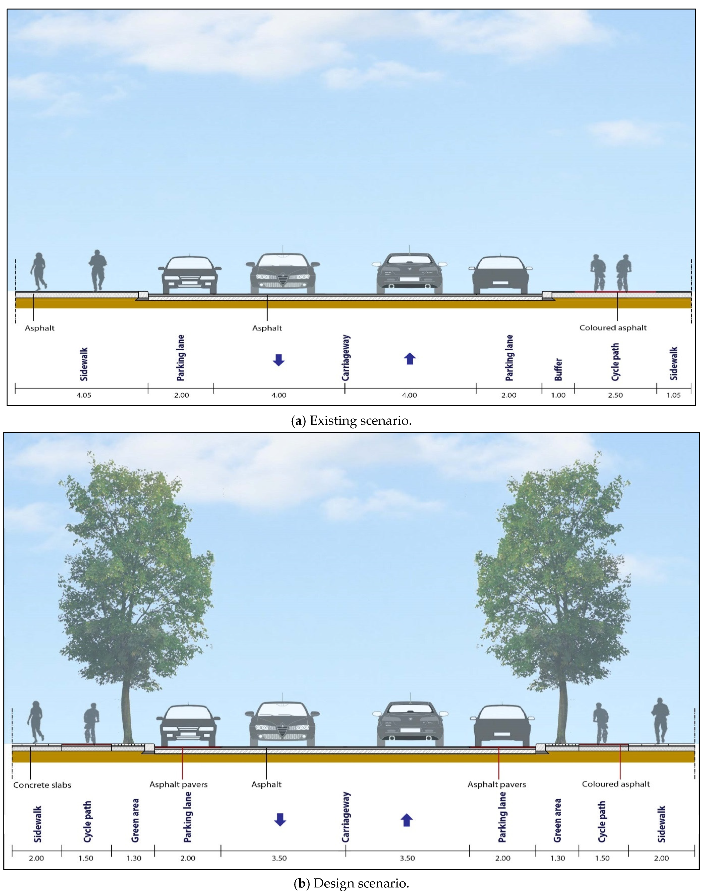
4.2. Design 1—Urban Streets with the Features of Rural Roads
- The steel median safety barrier was replaced with a blue colour concrete median barrier with a rounded shape (criterion A1, see Table 1);
- Pedestrian crossings with white zebra stripes were embedded in a red colour surface with printed bituminous concrete appearing as brick pavers (criteria S3, S4 and S8);
- The uneven and potholed pavement was replaced with an even, antiskid surface (criteria A1, A3, and E1);
- The carriageways without markings were marked with high-performance cold-hardened road markings delineating 3.50 m wide traffic lanes (criteria A3, S3, and S8);
- Both sides of the road had one-way separated bicycle lanes installed (criteria A2, E1, E2, E3, S3, S5, and S9), with these features:
- −
- Raised from the street and flush with the sidewalk,
- −
- Width equal to 1.50 m,
- −
- Red colour bituminous concrete surface,
- −
- A 0.70 m buffer from the street via a basalt curb and concrete square slabs,
- −
- A 1.00 m buffer from the sidewalks made by concrete square slabs, trees with regular spacing, and lighting poles with LED sources;
- Continuous and accessible sidewalks 1.50 m wide were installed (criteria S3 and S5);
- The existing, obstructive advertising signs were removed from sidewalks (criteria A1 and A2).
4.3. Design 2—Inadequate Layout
- The median was completely redesigned with new trees (indigenous and hardy species) and pedestrian and bicycle paths (criteria A1, A2, E2, E3, S3, S4, and S5);
- In the median, a continuous pedestrian route was created, with central plazas and benches at regular intervals (criteria L1 and L2);
- In the median, one-way separated bicycle lanes were introduced, flush with the sidewalk, 1.50 m wide, with a red colour bituminous concrete surface, and a 0.70 m buffer from the street (criterion S5);
- Parking in the median was removed (criterion S3);
- The former counter-flow bicycle lane was removed (criterion L1);
- Parallel parking was introduced in the nearside with a different surface, i.e., a red colour surface with printed bituminous concrete appearing as brick pavers (criteria A3 and E1);
- Bulb-outs were introduced in all the pedestrian crossings (criteria S4 and S6);
- Lighting poles with LED sources were employed (criteria L2 and S9);
- Antiskid surfaces were added (criteria A3 and E1);
- High-performance cold-hardened road markings were specified, delineating 3.50 m wide outer lanes (where buses are expected) and 3.00 m wide inner lanes (criteria A3, S3, and S8);
- On each side of the Viale, new continuous and accessible sidewalks with concrete square slabs were installed (criteria L1 and S7).
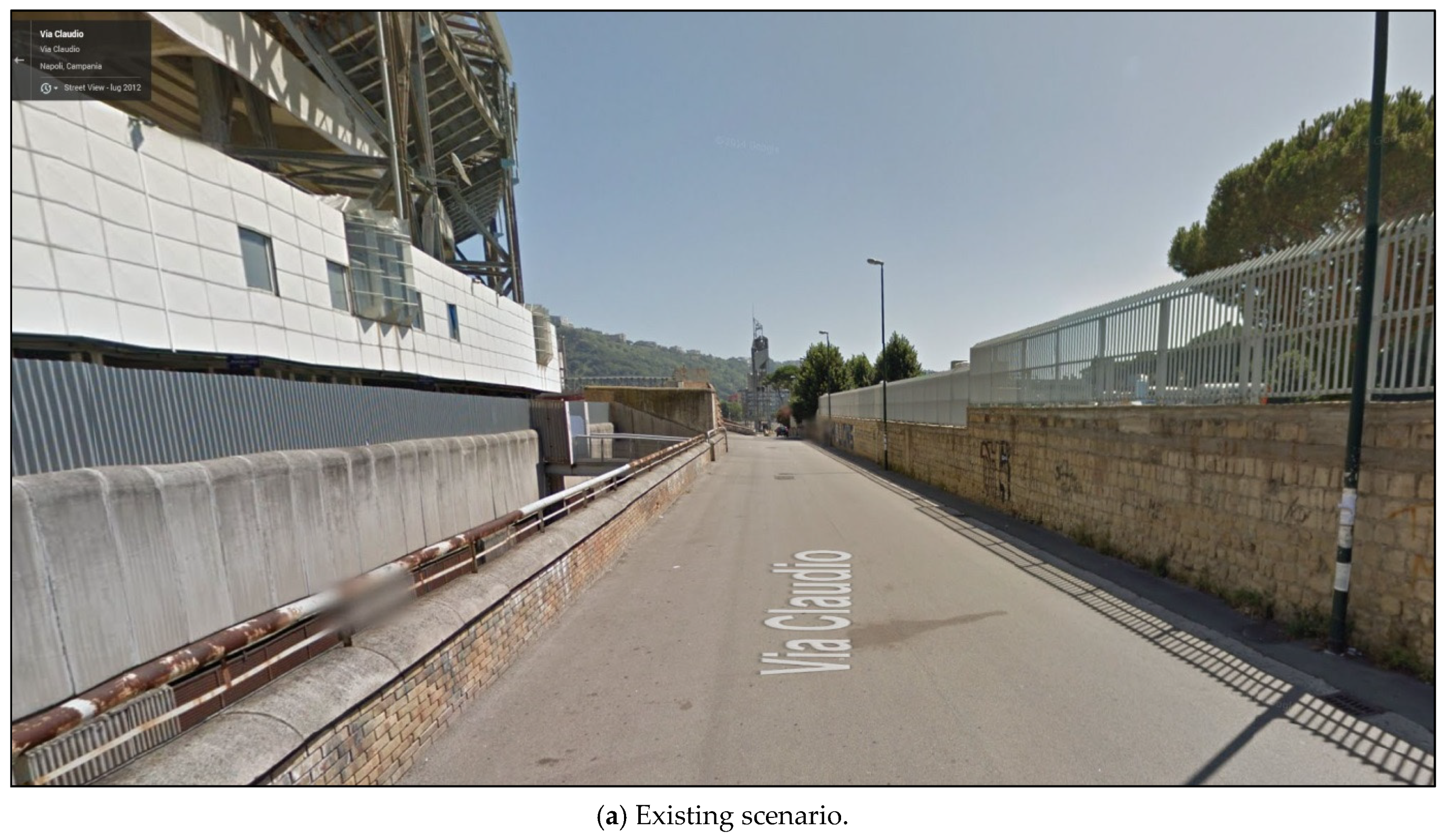
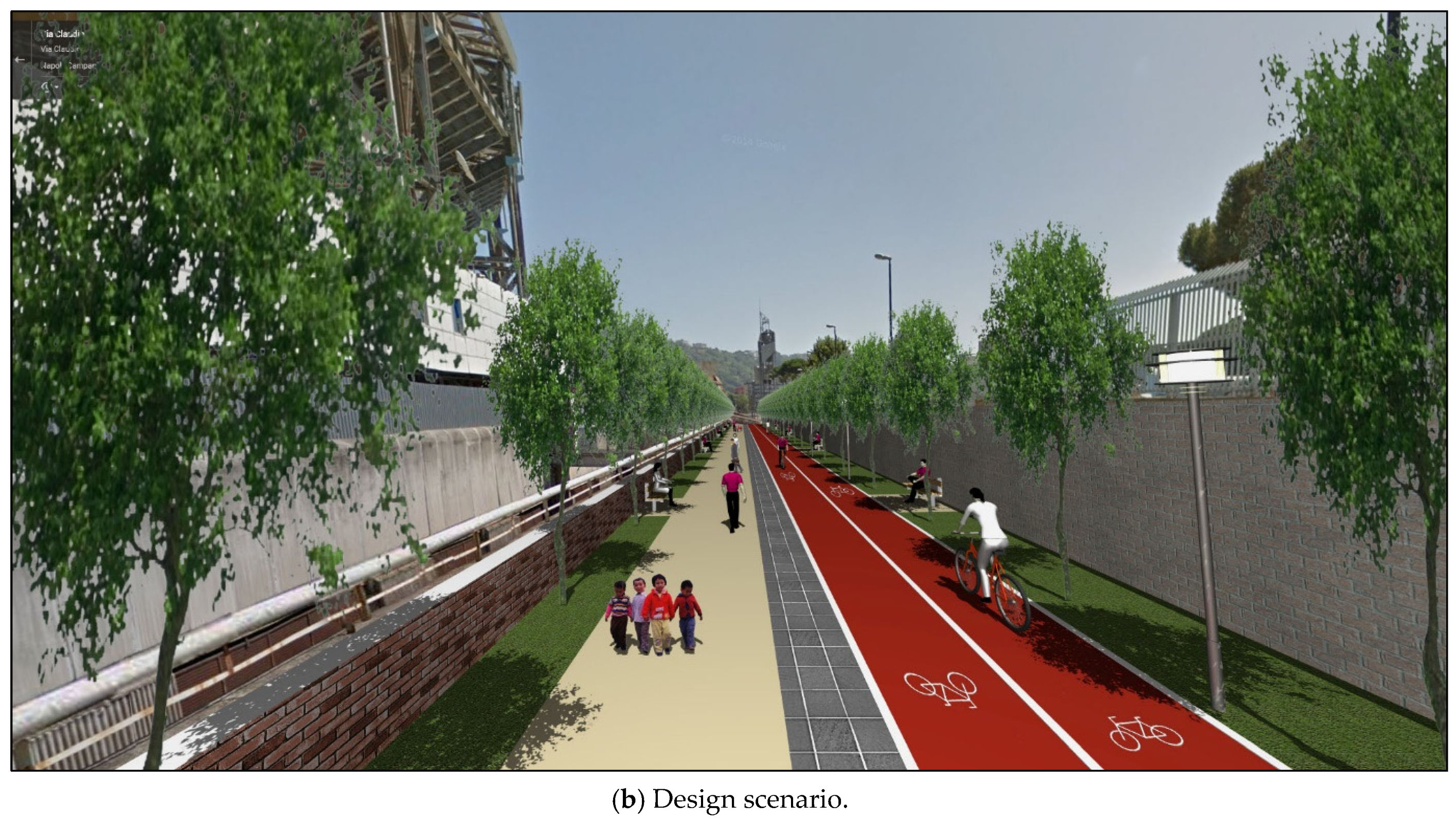
4.4. Design 3—Inadequate Pedestrian and Bicycle Paths
- The replacement of the existing two-way bicycle lane with one-way separated bicycle lanes on both sides (criteria L1, S3, and S5) that were flush with the sidewalk, including a 1.50 m wide, red coloured, bituminous concrete surface, separated by a 1.30 m basalt curb buffer, street trees, and LED street lights (criteria A2, E1, E2, E3, S3, S5, and S9);
- Continuous and accessible pedestrian paths 2.00 m wide (criteria S4 and S7);
- Bulb-outs in all the pedestrian crossings (criteria S4 and S6);
- Lane widths that were reduced from 4.00 m to 3.50 m (criterion S3);
- Antiskid surfaces (criteria A3 and E1);
- High-performance cold-hardened road markings (criteria A3, S3, and S8).
4.5. Design 4—Conflicts between Pedestrians, Cyclists, and Cars
- The removal of the concrete pavement (criteria A1 and A2);
- The installation of green strips on both sides with grass, trees, benches, and lighting poles with LED sources (criteria E1, E2, E3, L1, L2, and S9);
- Installation of a two-way bicycle lane, flush with the sidewalk, 3.00 m wide, with a red colour bituminous concrete surface (criteria L1, L2, S3, and S5);
- Installation of a 1.00 m wide buffer between the bicycle lane and sidewalk, using concrete square slabs (criteria S3, S4, and S5);
- Installation of a 2.00 m wide coloured sidewalk (criteria S3 and S4);
- Installation of ‘gateway’ architectural features at its ends (criteria A1, L1, and L2).
5. Results and Discussion
6. Conclusions
Author Contributions
Funding
Institutional Review Board Statement
Informed Consent Statement
Data Availability Statement
Acknowledgments
Conflicts of Interest
References
- Transportation Research Board. International Perspectives of Urban Street Design. Transportation Research Circular E-C097. 2006. Available online: http://onlinepubs.trb.org/onlinepubs/circulars/ec097.pdf (accessed on 1 September 2022).
- Gregg, K.; Hess, P. Complete streets at the municipal level: A review of American municipal complete street policy. Int. J. Sustain. Transp. 2019, 13, 407–418. [Google Scholar] [CrossRef]
- Institute of Transportation Engineering. Designing Walkable Urban Thoroughfares: A Context Sensitive Approach; Publication No. RP-036A; Institute of Transportation Engineering: Washington, DC, USA, 2010; Available online: http://library.ite.org/pub/e1cff43c-2354-d714-51d9-d82b39d4dbad (accessed on 1 September 2022).
- Institute of Transportation Engineering. Integration of Safety in the Project Development Process and Beyond: A Context Sensitive Approach. 2015. Available online: http://library.ite.org/pub/e4edb88b-bafd-b6c9-6a19-22e98fedc8a9 (accessed on 1 September 2022).
- McCann, B. Completing Our Streets: The Transition to Safe and Inclusive Transportation Networks. Island Press: Washington, DC, USA, 2013. [Google Scholar]
- National Association of City Transportation Officials. Urban Street Design Guide; National Association of City Transportation Officials: New York, NY, USA, 2013; Available online: https://nacto.org/publication/urban-street-design-guide/ (accessed on 1 September 2022).
- National Complete Streets Coalition. Introduction to Complete Streets. 2015. Available online: https://smartgrowthamerica.org/resources/introduction-to-complete-streets/ (accessed on 1 September 2022).
- New York City Department of Transportation. Street Design Manual, Updated Second Edition. 2015. Available online: https://nacto.org/wp-content/uploads/2016/05/2-6_NYCDOT-Street-Design-Manual-2nd-ed-ch-2_2015.pdf. (accessed on 1 September 2022).
- Schlossberg, M.; Rowell, J.; Amos, D.; Sanford, K. Rethinking Streets: An Evidence-Based Guide to 25 Complete Street Transformations. Sustainable Cities Initiative, University of Oregon: Eugene, OR, USA, 2013. [Google Scholar]
- Rupprecht, S.; Brand, L.; Böhler-Baedeker, S.; Brunner, L.M. Guidelines for Developing and Implementing Sustainable Urban Mobility Plan, 2nd ed.; Rupprecht Consult Editor: Cologne, Germany, 2019. [Google Scholar]
- Alexandria Department of Transportation and Environmental Services. Alexandria Complete Streets Design Guidelines. 2022. Available online: https://www.alexandriava.gov/transportation-planning/complete-streets-design-guidelines (accessed on 1 September 2022).
- Pulsipher, D.; Lamie, R.; Johnson, K.; Price, B. Denver Complete Streets Design Guidelines. 2020. Available online: https://www.denvergov.org/files/assets/public/doti/documents/standards/doties-017.0_complete_streets_guidelines.pdf (accessed on 1 September 2022).
- Stantec Consulting Ltd and the City of Edmonton. Complete Streets Design and Construction Standards, City of Edmonton. 2018. Available online: https://bicycleinfrastructuremanuals.com/manuals4/CompleteStreets_DesignStandards_Sept2018.pdf (accessed on 1 September 2022).
- London Canada. London Complete Streets Design Manual. 2018. Available online: https://london.ca/sites/default/files/2020-09/Complete%20Streets%20Design%20Manual.pdf (accessed on 1 September 2022).
- Montgomery County Department of Transportation. Montgomery County Complete Streets. 2021. Available online: https://montgomeryplanning.org/wp-content/uploads/2022/03/Montgomery-County-CSDG_Approved-2021.pdf (accessed on 1 September 2022).
- Department for Transport. Manual for Streets; Thomas Telford Publishing: London, UK, 2007. Available online: www.gov.uk/government/uploads/system/uploads/attachment_data/file/341513/pdfmanforstreets.pdf (accessed on 1 September 2022).
- Transport for London. Streetscape Guidance, 4th ed; Transport for London: London, UK, 2019. Available online: https://content.tfl.gov.uk/streetscape-guidance-.pdf. (accessed on 1 September 2022).
- Wegman, F.; Aarts, L. Advancing Sustainable Safety: National Road Safety Outlook for 2005–2020. SWOV Institute for Road Safety Research, Leidschendam, The Netherlands. 2006. Available online: www.swov.nl/sites/default/files/publicaties/rapport/dmdv/advancing_sustainable_safety.pdf (accessed on 1 September 2022).
- Sandt, L.; Brookshire, K.; Heiny, S.; Blank, K.; Harmon, K. Toward a Shared Understanding of Pedestrian Safety: An Exploration of Context, Patterns, and Impacts. Pedestrian and Bicycle Information Center. 2020. Available online: https://www.pedbikeinfo.org/cms/downloads/PBIC_Pedestrian%20Safety%20Background%20Piece_7-2.pdf (accessed on 1 September 2022).
- Brown, B.B.; Werner, C.M.; Tribby, C.P.; Miller, H.J.; Smith, K.R. Transit use, physical activity, and body mass index changes: Objective measures associated with complete street light-rail construction. Am. J. Public Health 2015, 105, 1468–1474. [Google Scholar] [CrossRef]
- ETSC. PIN FLASH Report 37: Safer Roads, Safer Cities: How to Improve Urban Road Safety in the EU. 2019. Available online: https://etsc.eu/wp-content/uploads/PIN-FLASH-37-FINAL.pdf (accessed on 1 September 2022).
- European Commission. EU Road Safety Policy Framework 2021–2030, Next Steps towards “Vision Zero”. 2020. Available online: https://op.europa.eu/en/publication-detail/-/publication/d7ee4b58-4bc5-11ea-8aa5-01aa75ed71a1 (accessed on 1 September 2022).
- Song, X.; Cao, M.; Zhai, K.; Gao, X.; Wu, M.; Yang, T. The effects of spatial planning, well-being, and behavioural changes during and after the COVID-19 pandemic. Front. Sustain. Cities 2021, 3, 686706. [Google Scholar] [CrossRef]
- Verheijen, M. Functional Ambiance. De Urbanisten. 2016. Available online: www.urbanisten.nl/pdf/Functional%20Ambiance%20-%20artikel%20Huig.pdf (accessed on 1 September 2022).
- United Nations. Report of the World Commission on Environment and Development: Our Common Future. 1987. Available online: http://www.un-documents.net/our-common-future.pdf (accessed on 1 September 2022).
- Vezzoli, C.; Manzini, E. Design for Environmental Sustainability; Springer: London, UK, 2008. [Google Scholar]
- Grammenos, F.; Lovegrove, G. Remaking the City Street Grid—A Model for Urban and Suburban Development. McFarland Publishers: Jefferson, NC, USA, 2015. [Google Scholar]
- United Nations. Resolution 74/299 Improving Global Road Safety. 2020. Available online: https://documents-dds-ny.un.org/doc/UNDOC/GEN/N20/226/30/PDF/N2022630.pdf?OpenElement. (accessed on 1 September 2022).
- World Health Organization. Global Status Report on Road Safety 2018; World Health Organization: Geneva, Switzerland, 2018.
- Austroads. Guide to Road Safety Part 6: Managing Road Safety Audits. Austroads Publication AGRS06/19: Sydney, NSW, Australia, 2019.
- FHWA. A Systemic Approach to Safety: Using Risk to Drive Action. Report FHWA SA-15-054. 2016. Available online: https://safety.fhwa.dot.gov/systemic/fhwasa15054/apprch.pdf. (accessed on 1 September 2022).
- Montella, A.; Guida, C.; Mosca, J.; Lee, J.; Abdel-Aty, M. Systemic approach to improve safety of urban unsignalized intersections: Development and validation of a Safety Index. Acc. Anal. Prev. 2020, 141, 105523. [Google Scholar] [CrossRef]
- Thomas, L.; Sandt, L.; Zegeer, C.; Kumfer, W.; Lang, K.; Lan, B.; Horowitz, Z.; Butsick, A.; Toole, J.; Schneider, R. Systemic Pedestrian Safety Analysis. NCHRP Research Report 893. 2018. Available online: https://www.nap.edu/download/25255 (accessed on 1 September 2022).
- Aarts, L.; van Schagen, I. Driving speed and the risk of road crashes: A review. Accid. Anal. Prev. 2006, 38, 215–224. [Google Scholar] [CrossRef]
- Hauer, E. Speed and safety. Transp. Res. Rec. 2009, 2103, 10–17. [Google Scholar] [CrossRef] [Green Version]
- Montella, A.; Imbriani, L.L.; Marzano, V.; Mauriello, F. Effects on speed and safety of point-to-point speed enforcement systems: Evaluation on the urban motorway A56 Tangenziale di Napoli. Acc. Anal. Prev. 2015, 75, 164–178. [Google Scholar] [CrossRef]
- Montella, A.; Mauriello, F.; Permetti, M.; Rella Riccardi, M. Rule discovery to identify patterns contributing to overrepresentation and severity of run-off-the-road crashes. Acc. Anal. Prev. 2021, 155, 106119. [Google Scholar] [CrossRef]
- Neuman, T.R.; Slack, K.L.; Hardy, K.K.; Bond, V.L.; Potts, I.; Alberson, B.; Lerner, N. NCHRP Report 500: Guidance for Implementation of the AASHTO Strategic Highway Safety Plan: A Guide for Reducing Speeding-Related Crashes. Transportation Research Board: Washington, DC, USA, 2009; Volume 23. [Google Scholar]
- National Highway Traffic Safety Administration. MMUCC Guideline: Model Minimum Uniform Crash Criteria, 5th ed.; Report DOT HS 812 433; U.S. Department of Transportation: Washington, DC, USA, 2017.
- Masoud, A.; Lee, A.; Faghihi, F.; Lovegrove, G. Building sustainably safe and healthy communities with the fused grid development layout. Can. J. Civ. Eng. 2015, 42, 1063–1072. [Google Scholar] [CrossRef] [Green Version]
- Masoud, A.R.; Idris, A.O.; Lovegrove, G. Modelling the impact of fused grid network design on mode choice behavior. J. Transp. Health 2019, 15, 100627. [Google Scholar] [CrossRef]
- Rella Riccardi, M.; Mauriello, F.; Sarkar, S.; Galante, F.; Scarano, A.; Montella, A. Parametric and non-parametric analyses for pedestrian crash severity prediction in Great Britain. Sustainability 2022, 14, 3188. [Google Scholar] [CrossRef]
- Prato, C.G.; Kaplan, S.; Rasmussen, T.K.; Hels, T. Infrastructure and spatial effects on the frequency of cyclist-motorist collisions in the Copenhagen Region. J. Transp. Saf. Secur. 2016, 8, 346–360. [Google Scholar] [CrossRef] [Green Version]
- Goerke, D.; Zolfaghari, E.; Marek, A.P.; Endorf, F.W.; Nygaard, R.M. Incidence and profile of severe cycling injuries after bikeway infrastructure changes. J. Community Health 2020, 45, 542–549. [Google Scholar] [CrossRef] [PubMed]
- Brijs, T.; Mauriello, F.; Montella, A.; Galante, F.; Brijs, K.; Ross, V. Studying the effects of an advanced driver-assistance system to improve safety of cyclists overtaking. Acc. Anal. Prev. 2022, 174, 106763. [Google Scholar] [CrossRef] [PubMed]
- CROW. Design Manual for Bicycle Traffic; CROW: Ede, The Netherlands, 2017. [Google Scholar]
- Pulvirenti, G.; Distefano, N.; Leonardi, S.; Tollazzi, T. Are double-lane roundabouts safe enough? A chaid analysis of unsafe driving behaviors. Safety 2021, 7, 20. [Google Scholar] [CrossRef]
- López, G.; de Oña, J.; Garach, L.; Baena, L. Influence of deficiencies in traffic control devices in crashes on two-lane rural roads. Acc. Anal. Prev. 2016, 96, 130–139. [Google Scholar] [CrossRef]
- American Association of State Highway and Transportation Officials. Highway Safety Manual, 1st ed.; American Association of State Highway and Transportation Officials: Washington, DC, USA, 2010. [Google Scholar]
- Montella, A.; de Oña, R.; Mauriello, F.; Rella Riccardi, M.; Silvestro, G. A data mining approach to investigate patterns of powered two-wheeler crashes in Spain. Acc. Anal. Prev. 2020, 134, 105251. [Google Scholar] [CrossRef]
- Moral Garcia, S.; Castellano, J.G.; Mantas, C.J.; Montella, A.; Abellán, J. Decision tree ensemble method for analyzing traffic accidents of novice drivers in urban areas. Entropy 2019, 21, 360. [Google Scholar] [CrossRef] [Green Version]
- Lantieri, C.; Costa, M.; Vignali, V.; Acerra, E.M.; Marchetti, P.; Simone, A. Flashing in-curb LEDs and beacons at unsignalised crosswalks and driver’s visual attention to pedestrians during nighttime. Ergonomics 2022, 64, 330–341. [Google Scholar] [CrossRef]
- Rella Riccardi, M.; Mauriello, F.; Scarano, A.; Montella, A. Analysis of contributory factors of fatal pedestrian crashes by mixed logit model and association rules. Int. J. Inj. Control. Saf. Promot. 2022; Epub ahead of print. [Google Scholar] [CrossRef]
- Langdon, D.; Management Consulting. Life Cycle Costing (LCC) as a Contribution to Sustainable Construction. Guidance on the Use of the LCC Methodology and Its Application in Public Procurement. Final Guidance. 2007. Available online: https://ec.europa.eu/docsroom/documents/5060/attachments/1/translations/en/renditions/pdf (accessed on 4 October 2022).
- Transport for London. Walking Action Plan. Making London the World’s Most Walkable City. 2018. Available online: https://content.tfl.gov.uk/mts-walking-action-plan.pdf (accessed on 23 September 2022).
- European Parliament. Directive 2008/96/EC on Road Infrastructure Safety Management; European Parliament: Brussels, Belgium, 2008.
- European Parliament. Directive (EU) 2019/1936 of the European Parliament and of the Council of 23 October 2019 Amending Directive 2008/96/EC on Road Infrastructure Safety Management; European Parliament: Brussels, Belgium, 2019.
- Montella, A. A comparative analysis of hotspot identification methods. Acc. Anal. Prev. 2010, 42, 571–581. [Google Scholar] [CrossRef] [PubMed]
- World Road Association. Road Safety Manual: A Guide for Practicioners. 2019. Available online: http://roadsafety.piarc.org/en. (accessed on 4 October 2022).
- Montella, A. Roundabouts. In Safe Mobility: Challenges, Methodology and Solutions; Lord, D., Washington, S., Eds.; Transport and Sustainability; Emerald Publishing Limited: Bingley, UK, 2018; Volume 11, pp. 147–174. [Google Scholar] [CrossRef]
- Montella, A.; Turner, S.; Chiaradonna, S.; Aldridge, D. International overview of roundabout design practices and insights for improvement of the Italian standard. Can. J. Civ. Eng. 2013, 40, 1215–1226. [Google Scholar] [CrossRef]
- Rodegerdts, L.; Bansen, J.; Tiesler, C.; Knudsen, J.; Myers, E.; Johnsonm, M.; Moule, M.; Persaud, B.; Lyon, C.; Hallmark, S.; et al. Roundabouts: An Informational Guide, 2nd ed.; NCHRP Report 672; Transportation Research Board: Washington, DC, USA, 2010. [Google Scholar]
- Federal Highway Administration. Road Safety Audits Guidelines; Report No. FHWA-SA-06-06; U.S. Department of Transportation: Washington, DC, USA, 2006.
- Federal Highway Administration. Separated Bike Lane: Planning and Design Guide; Report No. FHWA-HEP-15-025; U.S. Department of Transportation: Washington, DC, USA, 2015. [Google Scholar]
- Massachusetts Department of Transportation. Separated Bike Lane Planning & Design Guide; Massachusetts Department of Transportation: Boston, MA, USA, 2015.
- National Association of City Transportation Officials. Urban Bikeway Design Guide, 2nd ed.; National Association of City Transportation Officials: New York, NY, USA, 2014. [Google Scholar]
- IBI GROUP. Background Report D: Final Report June 2020. Thorold Transportation Master Plan Complete Streets Strategy. 2020. Available online: https://www.thorold.ca/en/city-hall/resources/D-CompleteStreetsStrategy_FINAL_06-2020.pdf (accessed on 9 September 2022).
- IRAP. Road Safety Toolkit. Available online: https://toolkit.irap.org/safer-road-treatments/sight-distance-obstruction-removal/ (accessed on 20 September 2022).
- United Nations. Vienna Convention on Road Signs and Signals E/CONF.56/17/Rev.1. 1968. Available online: https://unece.org/DAM/trans/conventn/Conv_road_signs_2006v_EN.pdf. (accessed on 20 September 2022).
- Waka Kotahi NZ Transportation Agency. Traffic Control Devices Manual Part 1. 2010. Available online: https://www.nzta.govt.nz/assets/resources/traffic-control-devices-manual/docs/part-1-general-requirements.pdf (accessed on 20 September 2022).
- Waka Kotahi NZ Transportation Agency. Specification for High Performance Roadmarking, NZTA P30. 2009. Available online: https://www.nzta.govt.nz/assets/resources/high-performance-roadmarking/docs/high-performance-roadmarking.pdf (accessed on 20 September 2022).
- Zalesinska, M.; Wandachowicz, K. On the quality of street lighting in pedestrian crossings. Energies 2021, 14, 7349. [Google Scholar] [CrossRef]
- Transport Canada. Complete Streets: Making Canada’s Roads Safer for All. 2009. Available online: https://publications.gc.ca/collections/collection_2012/tc/T41-1-72-eng.pdf (accessed on 9 September 2022).
- Sousa, L.R.; Rosales, J. Contextually complete streets. In Proceedings of the Green Streets and Highways Conference 2010, Denver, CO, USA, 14–17 November 2010. [Google Scholar] [CrossRef]
- Shapard, J.; Cole, M. Do complete streets cost more than in complete streets? Transp. Res. Rec. 2013, 2393, 134–138. [Google Scholar] [CrossRef]


| General Criteria (Section #) | Specific Criteria | Integration with Complete Streets Criteria |
|---|---|---|
| Aesthetics (3.2) | A1 Enhancement of the urban environment to recover historical urban character and realize historical area planning goals | Full integration between street design and the planning for redevelopment of the public space |
| A2 Integration of materials, colours, lighting, and treatment of green spaces | Sustainable approach to integrate the street design and the built environment | |
| A3 Durable materials | Requirements for the use of durable pavements, markings, signs, lightings, and street furniture to reduce the unpleasantness caused by deterioration during its life cycle | |
| Environment (3.3) | E1 Eco-design | Life Cycle Design and Life Cycle Assessment of building products |
| E2 Planting and trees | Use of green space to form a natural filter and buffer from pollutant gases, dust, and noise as well as to reduce urban heat islands | |
| E3 Reduction in traffic-related air pollution and noise | Strengthening of the community system design approach to reduce auto trips and promote healthier active transport choices | |
| Liveability (3.4) | L1 Usability and comfort of the public outdoor space system | Attention to the functional and environmental design aspects of public space to ensure that end user and lifecycle impacts are addressed with a view toward sustainability |
| L2 Creation of a public space destination in the urban landscape which affects activities and social relations | Coordination between urban planners, landscape architects, and transportation engineers in developing the design of the street as a public space destination in the urban landscape | |
| Safety (3.5) | S1 Road safety inspections | Introduction of formal road safety inspections of the existing network |
| S2 Road safety audits | Introduction of formal road safety audit of all plans and designs prior to construction | |
| S3 SMARTer Growth Neighbourhood design | Safe system design of community land use and transport to reduce auto use and speeding | |
| S4 Safe pedestrian routes and crosswalks | Specific criteria to provide a comprehensive, safe pedestrian route network | |
| S5 Safe cycle routes and crossings | Specific criteria to provide a comprehensive, safe, and continuous cycle route network | |
| S6 Sight distance | Explicit consideration of visibility from the perspective of all roadway users | |
| S7 Transit and pedestrian accessibility | Link between accessibility and safety | |
| S8 Traffic control devices | High-performance traffic control devices as explicit safety criterion (e.g., roundabouts) | |
| S9 Lighting | Use of high-performance lighting as explicit safety criterion (e.g., solar power LEDs) |
| General Criteria | Specific Criteria | Design 1 | Design 2 | Design 3 | Design 4 |
|---|---|---|---|---|---|
| Aesthetics | A1 Enhancement of the urban environment to recover historical urban character and realize historical area planning goals | √ | √ | √ | |
| A2 Integration of materials, colours, lighting, and treatment of green spaces | √ | √ | √ | √ | |
| A3 Durable materials | √ | √ | √ | ||
| Environment | E1 Eco-design | √ | √ | √ | √ |
| E2 Planting and trees | √ | √ | √ | √ | |
| E3 Reduction in traffic-related air pollution and noise | √ | √ | √ | √ | |
| Liveability | L1 Usability, comfort and safety of the public outdoor space system | √ | √ | √ | |
| L2 Creation of a public space destination in the urban landscape which affects activities and social relations | √ | √ | |||
| Safety | S1 Road safety inspections | √ | √ | √ | √ |
| S2 Road safety audits | √ | √ | √ | √ | |
| S3 Fused grid neighbourhood pattern | √ | √ | √ | √ | |
| S4 Safe pedestrian routes and crosswalks | √ | √ | √ | √ | |
| S5 Safe cycle routes and crossings | √ | √ | √ | √ | |
| S6 Sight distance | √ | √ | |||
| S7 Transit and pedestrian accessibility | √ | √ | |||
| S8 Traffic control devices | √ | √ | |||
| S9 Lighting | √ | √ | √ | √ |
Publisher’s Note: MDPI stays neutral with regard to jurisdictional claims in published maps and institutional affiliations. |
© 2022 by the authors. Licensee MDPI, Basel, Switzerland. This article is an open access article distributed under the terms and conditions of the Creative Commons Attribution (CC BY) license (https://creativecommons.org/licenses/by/4.0/).
Share and Cite
Montella, A.; Chiaradonna, S.; Mihiel, A.C.d.S.; Lovegrove, G.; Nunziante, P.; Rella Riccardi, M. Sustainable Complete Streets Design Criteria and Case Study in Naples, Italy. Sustainability 2022, 14, 13142. https://doi.org/10.3390/su142013142
Montella A, Chiaradonna S, Mihiel ACdS, Lovegrove G, Nunziante P, Rella Riccardi M. Sustainable Complete Streets Design Criteria and Case Study in Naples, Italy. Sustainability. 2022; 14(20):13142. https://doi.org/10.3390/su142013142
Chicago/Turabian StyleMontella, Alfonso, Salvatore Chiaradonna, Alessandro Claudi de Saint Mihiel, Gord Lovegrove, Pietro Nunziante, and Maria Rella Riccardi. 2022. "Sustainable Complete Streets Design Criteria and Case Study in Naples, Italy" Sustainability 14, no. 20: 13142. https://doi.org/10.3390/su142013142