1. Introduction
In urban areas, there are insufficient and inappropriately distributed service locations that contribute to spatial inequity in service provision [
1]. This imbalance is especially prominent in metropolitan areas due to the insufficient capacity of basic infrastructure and service supply caused by rapid urban growth and high population density [
2]. Under such circumstances, spatial inequality has become a challenge in the resilience and sustainability of urban governance [
3]. Since the 1990s, the proposal of the New Public Service Theory has led government public administrations to adopt citizens’ interests as their main priority [
4]. Faced with the scarcity of urban resources, governments find themselves not only in the position of control, but also tasked with helping citizens to realize their public interests, so that every citizen can have equal access to education, medical care, recreational facilities, and other social public services. Since then, a large volume of studies have promoted the integration of urban public services from theory to practice and have sought the best possible scheme for a fair distribution of public services on the basis of scale economy and service efficiency [
5,
6,
7].
As for the equity of public service, accessibility is an important indicator that reflects the ease by which people can reach their desired activity sites [
8]. With the support of GIS and spatial analysis methods, the accessibility of a public service is evaluated by measuring the nearest facility from a given point. However, in practice, the accessibility of public services is often affected by administrative boundaries, which leads to differences between the actual accessibility of public service facilities and the planned service scope [
9]. Normally, the public service agencies established by governments serve only residents who have registered in their respective administrative units, which means registration in a certain territory is the prerequisite for residents to be able to enjoy public services or use service facilities. Even if certain residents live very close to a public service agency in the adjacent administrative unit, the adjacent agency cannot provide services to them. Therefore, the division of administrative boundaries restricts the optimization of public service accessibility and intensifies the fragmentation of public service supply and the inequality of that access.
A change in the mode of governance is therefore essential to improving the resilience and sustainability of public service delivery through collaborative, integrative, and multi-actor network approaches [
10]. The integration of fragmented public service supply is an important means for improving the accessibility and equalization of public services. Especially when facing limited urban resources and the need for more equitable public services, the question of how to improve the integration of public services through cross-boundary supply is of great significance to enhancing urban community resilience and sustainable governance.
However, problems of this nature have been paid minimal attention in empirical research. In this paper, we choose Community Public Service Centers (CPSCs, she qu shi wu shou li zhong xin) in Shanghai, China (i.e., the public service agency of the Shanghai Municipal Government), as an example to analyze the effect of cross-boundary supply on the accessibility of public services. Under the condition that the administrative scope and governmental function of these local administrative units remains unchanged, the innovative supply mode of CPSCs permits public services to be implemented across administrative boundaries, and the cooperation of public services between local administrative units enables the integration of fragmented public service supply and thus promotes equity, accessibility, and fairness within Shanghai’s public services.
With a brief literature review and an introduction of data and method, this paper introduces the background of CPSCs and their cross-boundary supply mode of public service delivery. Then, the paper quantitatively analyzes the improvement of the accessibility of public services following cross-boundary service reforms within CPSCs. This analysis was conducted to evaluate the influence of institutional innovation on the fairness of public service delivery. This paper aims to provide a reference for optimizing the supply mode of public services to improve the resilience within communities and sustainability of urban governance.
The proceeding structure of the paper is organized as follows.
Section 2 is a review of the existing literature.
Section 3 presents the data and methods used for the public service efficiency evaluation.
Section 4 introduces the establishment and development of CPSCs in Shanghai.
Section 5 presents the evaluation results, and
Section 6 and
Section 7 conclude the paper.
3. Data and Method
3.1. Method
Dijkstra’s algorithm is a method for finding the shortest path between a vertex and every other vertex, which was used here to solve the shortest-path problems in the graph [
41]. The algorithm’s main feature is to set the node at the beginning of the path as the center, then assign some initial distance values and try to improve upon them step-by-step until the distance to the destination vertex has been determined [
42]. The basics of Dijkstra’s algorithm can be described as follows.
First, define a source node and a targeted node. Second, the algorithm starts calculating from the source node. Once the algorithm finds the shortest path between the source node and another node, that node will be recorded and added to the shortest path. Third, the process continues until all the nodes have been gone through. This way, we will obtain the shortest distance from the source node to the targeted node.
3.2. Data Source
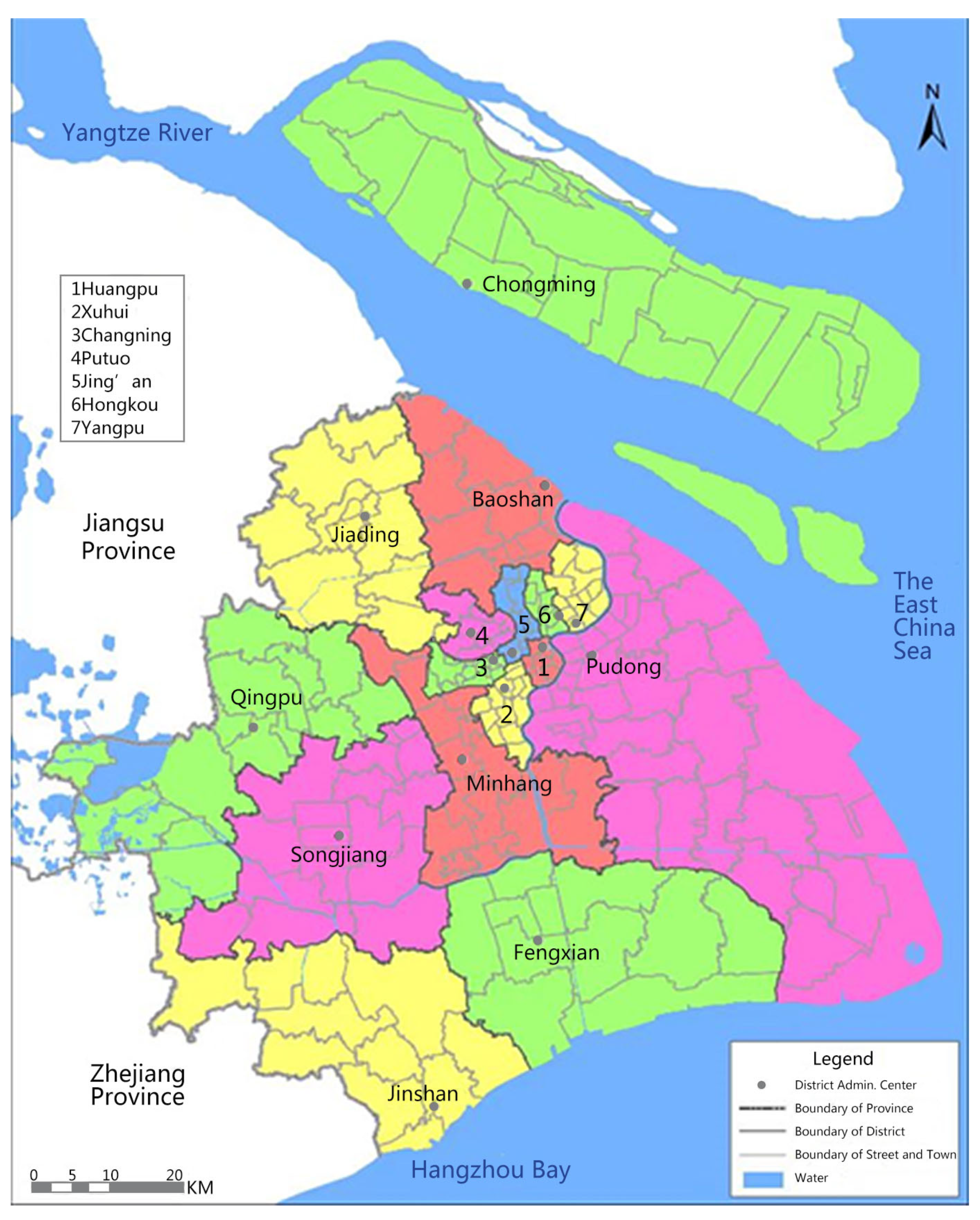
According to the Shanghai statistical yearbook, the total area of Shanghai is 6340.5 square kilometers, with a total permanent resident population of 24.24 million by the end of 2018. There were 16 municipal districts, 105 sub-districts, 109 townships, and 6053 neighborhood and village committees which were in charge of urban and rural communities in 2018 (
Figure 1).
The data used in this paper mainly include: (1) the base map of administrative divisions by the Shanghai Statistics Bureau as of 2018; (2) A Brief Introduction to Shanghai Administrative Divisions 2018; (3) the name and spatial location of 287 CPSCs in Shanghai; (4) navigation data of Shanghai (roads, rivers, buildings, etc.); (5) the latest satellite images of Shanghai, etc.
Firstly, an electronic database of the names of the 6053 neighborhood and village committees based on A Brief Introduction to Shanghai Administrative Divisions 2018 was generated. Secondly, the location, longitude, and latitude of each neighborhood committee and village committee was extracted according to the database and the navigation data of Shanghai. Then, the data of neighborhood and village committees were imported into ArcGIS, and a point feature was generated based on its longitude and latitude. Lastly, the location of each point feature was verified by comparing it with the base map of administrative districts, the geographic navigation data, and the latest satellite images of Shanghai in a unified coordinate system to guarantee the data accuracy.
3.3. Data Processing
“Accessibility” usually refers to the physical spatial distance from one place to another. In practice, it is also common to evaluate accessibility in terms of the time that is actually spent on transportation [
43]. For example, the 15 min community living circle proposed in the “Shanghai Master Plan 2017–2035” defines a distance within 15 mins’ walk as “favorable accessibility”. Therefore, this paper takes the walking time of ordinary people as the evaluation index of spatial accessibility.
First, the distance to the CPSC was calculated. Since residents live scattered across communities, the location of the neighborhood committee or village committee’s office was taken as the residents’ starting point in order to simplify calculations, and the CPSC was taken as the destination. Based on the geographic navigation data of Shanghai and Dijkstra’s algorithm, the shortest distance between residents and the CPSC was calculated. Second, the accessibility between residents and the CPSC was assessed. Based on the average walking speed of 4.8 km/h for an ordinary person [
44] and the shortest distance, the walking time between the neighborhood or village committee and the CPSC was calculated as the accessibility of the CPSC in this community. This paper assumes an ideal walking accessibility in which all of these location points are connected by a road network, and also that walking is not interfered with by traffic flow. Finally, the accessibility was classified. Based on the walking time, accessibility was divided into 7 levels, namely, less than or equal to 5 min (≤0.4 km), 5–10 min (0.4–0.8 km), 10–15 min (0.8–1.2 km), 15–20 min (1.2–1.6 km), 20–30 min (1.6–2.4 km), 30–60 min (2.4–4.8 km), and more than 1 h (>4.8 km). Since the government of Shanghai has been promoting the standardization of CPSCs since 2018, the difference in processing times between CPSCs could be neglected. Therefore, these differences would not influence the selection of CPSCs.
Then, the paper compares the accessibility of the CPSC with and without the restriction of the administrative boundaries of the local government. When considering the administrative boundary, residents can only go to the CPSC within their own sub-district/township jurisdiction and cannot cross the administrative boundary of their sub-district/township. When not considering the administrative boundary, residents can choose the nearest CPSC (which is not necessarily their registered one). The calculation process of the accessibility in the two conditions is the same. Dijkstra’s algorithm was then used to obtain the distribution of accessibility in these two conditions. In order to better display the accessibility differences between the different scenarios, Kriging interpolation was used to generate a planar spatial distribution map of the accessibility.
4. The CPSC in Shanghai
4.1. The Establishment and Development of CPSCs
In the 1990s, in order to solve the problematic need for multiple governmental departments to perform a single form of public service—a major cause of inconvenience for residents—Shanghai’s municipal government took the lead in exploring a mode of centralized and unified handling of public affairs at the community-level in specific institutions within the layers of local government. In 2006, Shanghai promoted this model across the whole city, and set up CPSCs in all sub-districts and townships in Shanghai.
Initially, CPSCs served as a front-line window for the government to provide government public services to citizens registered within a specific administrative boundary. CPSCs received their authorization from local administrative departments such as the Public Security Bureau, Civil Affairs Bureau, Social Security Bureau, etc. Thus, the CPSCs played the role of an agent in processing the delivery of public services including consultation, application processing, certificate issuing, and other services. In CPSCs, the public services of residents could proceed in one place. Residents had only to apply to the CPSC in the community they had registered in, and the CPSC would then conduct the necessary follow-up communications with each relevant administrative department. Since the establishment of CPSCs, they have taken on more than 170 public services, including the issuing of residence cards and social security cards (originally processed by Public Security Bureau), processing minimum living allowance applications (originally handled by the Civil Affairs Bureau), and the processing of unemployment and occupational injury (previously the responsibility of the Human Resources and Social Security Bureau). CPSCs were set up as facilities to integrate different services from multiple administrative departments, and the success of this initiative greatly improved the convenience of residents’ access to public services, avoiding the need for cumbersome applications to various departments.
In 2018, with the support of internet infrastructure and IT, a unified information exchange platform was established among the CPSCs across the entire city. This digital platform connected the CPSCs with each other, and now allows residents to file applications in any Shanghai CPSC. Since then, the restrictions upon service supply due to administrative boundaries has eased and the convenience of public services has further improved. At present, there are 287 CPSCs citywide, covering all sub-districts and townships. In addition, in some sub-districts and townships that are spread across relatively large geographical areas, more than one CPSC has been set up to improve the fairness of public service supply.
4.2. The Process of Service Supply across Administrative Boundaries
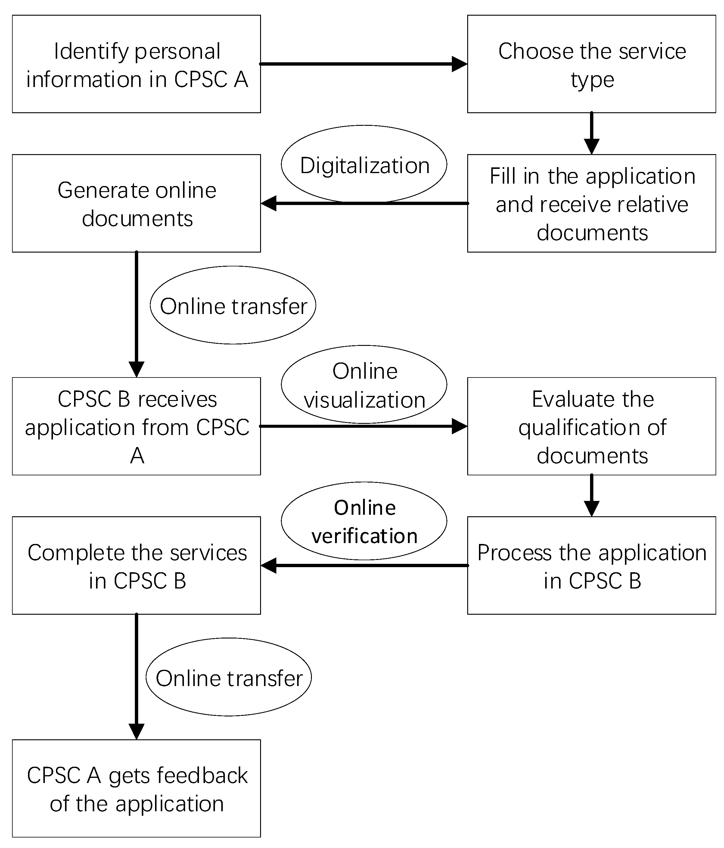
In order to realize full public service supply across administrative boundaries, the CPSC adopts a policy of “separation of receiving and handling”. This mode allows residents to apply for services in any CPSC in the city, which means they can apply in the nearest CPSC—which will not necessarily be the one in their residential community. In such scenarios, the application process is split between two CPSCs. After receiving the residents’ applications and related documents, the receiving <CPSC A> will use the local government’s information exchange platform to transfer the application materials to <CPSC B>, which is located in the residential community of the applicants. From that point onward, <CPSC B> will be responsible for the specific handling and review of that document. After this point, the residents will receive feedback of the processing results in the center where they filed the application. In the practical process of the operation, the counter staff of the receiving center use high-speed photographic apparatus to electronically transfer the resident’s documents to the actual handling center which belongs to the applicant’s residential community, where remote processing can be conducted (
Figure 2). This innovative mode avoids the need for residents to commute between different centers thanks to the rapid transmission of data, thus maximizing the convenience of their access to public services.
5. Findings
Based on the above analysis method and calculation process, the accessibility of public services in the sub-districts/townships with and without the restriction of local government administrative boundaries was measured. As can be seen from
Table 1, with administrative boundary restrictions applied, the number of communities with accessibility within 15 min and 15–30 min is 1853 and 2051, accounting for 30.59% and 33.88%, respectively, while the number of communities with accessibility greater than 30 min is 2150, accounting for 35.52%. In the absence of administrative boundary restrictions, the number of communities with accessibility within 15 min increases significantly from 1853 to 2224. This is an increase of 20.02%. The number of communities with 15–30 min accessibility increased slightly, by 125, with an increase rate of 6.09%. The number of CPSCs with accessibility greater than 30 min dropped from 2150 to 1653. In particular, the number of communities with more than one hour of accessibility decreased significantly, from 641 to 306, with a decrease rate of 52.26%. Thus, it was found that lifting the limitation of administrative divisions has a positive effect on the accessibility of CPSCs. The cross-boundary supply of CPSCs actually provides benefits for those people who do not live and register there. Since the set-up of cross-boundary supply of CPSCs, a brisk demand for public services has arisen. Based on the statistics recorded by a CPSC in Jing’an District, there are 8175 cross-boundary applications out of a total of 34,451, accounting for 23.73% from January to June 2020.
Next, the differences in the accessibility of CPSCs between urban communities and rural communities was explored. It can be seen that the accessibility of CPSCs in urban communities is significantly better than that of rural communities (
Table 2). The time needed for residents to reach CPSCs in urban communities is generally under 30 min, while the accessibility of CPSCs in rural communities is generally more than 30 min. After lifting the administrative boundaries for urban communities, the number of community centers accessible within 15 min and 15–30 min both increased. The ratio of communities accessible within 15 min increased from 37.74% to 43.94%, and the ratio of communities within 15–30 min increased from 37.50% to 39.04%. However, for rural communities, following the removal of administrative boundary restrictions, the number of communities with CPSCs accessible in less than 30 min essentially did not change. The greatest change in accessibility took place in the categories of over 1 h walking time and 30–60 min walking time. The proportion of communities with an accessibility of over 1 h reduced from 33.33% to 22.35%, and that of 30–60 min increased from 39.75% to 47.37%.
Shanghai is divided into an urban central area, a suburban area, and an outer-suburb area. From the perspective of spatial location (
Table 3), the CPSCs in the urban central area have the best accessibility, with the number of communities within 15 min exceeding 50% and those within 30 min exceeding 90%. The accessibility of CPSCs in the suburban area is relatively unsatisfactory. The travel time for more than 60% of the CPSCs to the communities sits between 20 and 60 min. The CPSCs in the outer suburbs had the worst accessibility. Less than a quarter of the communities were within 20 min accessibility. After the restriction of administrative boundaries was removed, the number of communities within 20 min accessibility in the central area increased significantly, from 71.07% to 84.37%. Meanwhile, more than 97% of the communities had less than 30 min of walking time to the CPSC. The accessibility of CPSCs in the suburban area and outer-suburban areas also improved, but only to a limited extent. The improvement was mainly reflected in the decrease of the number of communities with an accessibility of more than 1 h. Among this category, the number of that in suburban areas decreased from 11.44% to 3.53%, and the number of that in the outer suburbs decreased from 25.91% to 18.38%.
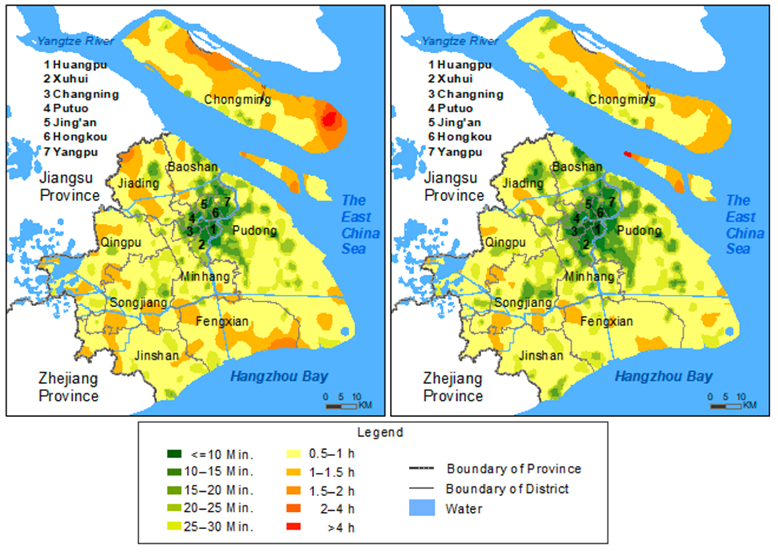
Below is a spatial distribution map of community accessibilities using Kriging interpolation analysis (
Figure 3). We can see the spatial difference between the accessibility before and after the lifting of boundary restrictions. Before that, the areas with poor accessibility were mainly located in the districts of Chongming, Fengxian, north-central Jiading, northern Baoshan, and the boundary areas around Minhang, Fengxian, Songjiang, and Baoshan. After lifting the administrative boundary restrictions, the green areas with good accessibility in the urban central area increased significantly, while the red areas with poor accessibility decreased significantly. Only scattered areas in Chongming, Fengxian, Jiading, and Songjiang continued to show red, while the accessibility of other areas improved significantly.
6. Discussion
6.1. The Role of Cross-Boundary Supply in Public Services
Although the existing literature focuses on the accessibility and equitable distribution of public services, the issue of fragmentation of public services brought about by administrative boundaries has been paid relatively little attention [
11,
12]. In this paper, we take the CPSCs in Shanghai an example to analyze the effect of cross-boundary supply on the accessibility of public services.
First, there were positive effects on the accessibility of public services upon lifting administrative boundary restrictions. The proportion of communities with an accessibility of less than 30 min increased from 64.47% to 72.69%, and the proportion of those with more than 1 h decreased from 10.59% to 5.06%. From the perspective of heterogeneity of location, the accessibility of almost all central areas shortened to within 30 min, and the accessibility of the suburbs and outer-suburbs also improved by removing administrative division boundaries. This was mainly reflected in the decrease of the number of communities with an accessibility of more than 1 h. It is worth noting that the mode of interregional cooperation is spreading not only in Shanghai, but also in Italy, Switzerland, and other Western countries [
32,
45]. Although existing studies argued that accessibility and equitable distribution should be improved by increasing the supply of public services [
13], this paper suggests improving the supply efficiency of public services through institutional reform by means of modern information technology is possible without increasing the supply of public services.
Second, it was found that the lifting of administrative boundaries improved accessibility only to a certain extent. As seen in the case of Shanghai, the accessibility of CPSCs in central areas remained much higher than that of suburban areas and outer-suburban areas. The greatest improvement seen was the increase of accessibilities of less than 30 min in central areas. However, in other areas, the most noticeable change seen was that many communities with an accessibility of more than one hour shortened to 30–60 min. The improvement of accessibility is closely related to that of the previous situation. Although lifting administrative boundaries can improve the fairness of public service delivery, it is still difficult to achieve a qualitative leap from poor accessibility to good accessibility. If the government of Shanghai wants to improve the accessibility of its public services, then increasing the number of CPSCs to complement lifting the restriction of administrative boundaries will be necessary.
6.2. Policy Implications on Urban Governance
By focusing on the effect of cross-boundary supply, the findings have broader implications for urban governance. First, the imbalanced distribution of public resources brought about by administrative boundaries must be faced. The role of the administrative boundaries of sub-districts and townships lies in providing geographical references for social and economic data collection. However, in the spatial planning of many cities in China, it is still common for authorities to use administrative boundaries for the distribution of public services, which causes many unreasonable problems. For spatially large, spread-out communities, the demand for public services is not always well met. However, for small, densely populated communities, public services are over-supplied, resulting in a waste of public resources. As demonstrated in this paper, by lifting the restrictions imposed by administrative boundaries, municipal administrators solve the problems of resource allocation and improve the efficiency and fairness of the use of public resources.
Second, cross-departmental and cross-regional integration and collaboration with the support of modern technology is key to the improvement of urban governance. Just as described by [
10], a new governance model for improving urban resilience is the adoption of flexible management approaches that do away with boundaries in favor of institutional integration and coordination. CPSCs and the model of “separation of receiving and handling” provide a useful reference for cross-regional public service organizations. In the process of rapid urbanization, the large-scale and long-distance migration of China’s population has become a widespread and common phenomenon. However, some governmental services are still handled at the place where the applicant’s residence registration (
hukou) belongs. If modern information technology can be used to optimize the platform for the organization and operation of public services in the backend, then these migrants should be able to enjoy the relevant public services in their current residences and avoid cross-regional commuting. In the future, it is necessary to further promote inter-city and inter-province public services on the basis of the inter-subdistrict/township model, so as to realize regional integrated development.
7. Conclusions
Fairness is an important value that governments must consider in their handling of public service distribution. Although clear administrative boundary divisions are the basis for urban governance, these same boundaries have also become a barrier that prevent citizens’ access to public services and are a major factor of the fragmentation of public service supply. Using the cross-boundary reform of CPSCs in Shanghai as a focus of study, this paper has conducted quantitative analysis on the accessibility of CPSCs with and without administrative boundary restrictions, thus aiming to provide some references for the development of equitable public service supply and innovative models of urban governance. This paper finds that Shanghai’s municipal government has managed to explore an innovative service supply which reaches a balance between a clear governmental delegation of administrative powers and responsibilities and an equitable distribution of public services. After the reform, the accessibility of public services increased remarkably, which means that this reform in Shanghai can serve as a very positive example by successfully accommodating effective and sustainable urban governance and satisfying accessibility for residents at the local governmental level.
The paper researches the accessibility of public services from the basic administrative unit, which to a certain extent contributes to the research on spatial accessibility at a microscopic scale. Restrictions due to administrative divisions that create invisible spatial boundaries on the accessibility of public services has been analyzed, and so has the question of how the use of modern technology can help to avoid both the fragmentation of public service supply and the obstruction of accessibility by administrative divisions. This paper, on the one hand, responds to the “fragmentation” problem of spatial distribution of public services. By coordinating various types of public services through CPSCs, it is possible to avoid spatial overlap and fragmentation in the spatial layout of different types of public services at the grassroots level. For residents, they can better identify the public service providers to which they belong. Meanwhile, the territorial responsibilities of local governments for the supply of public services will be clarified, thereby motivating local governments to better promote the equitable distribution of public services. On the other hand, via modern technology and digital means, this paper also responds to the cross-regional administrative coordination problem commonly faced by centralized governments in the supply of public services—that is, the barrier imposed by administrative boundaries on the flow of elements in the “Administrative District Economy”.
Concerning research methods, there is still room for further improvement—such as in the use of walking time as the index of accessibility evaluation in this study. The influence of transportation modes on accessibility is also significant [
46]. Future studies should factor transportation modes into the evaluation of accessibility to help render the evaluation results more accurate and provide a better reference for the distribution of public service resources.


