Review

Crowdsourcing Public Engagement for Urban Planning in the Global South: Methods, Challenges and Suggestions for Future Research

by
El Bachir Diop
1,*,
Jérôme Chenal
1,2,
Stéphane Cédric Koumetio Tekouabou
1 and
Rida Azmi
1
1
Center of Urban Systems, Mohammed VI Polytechnic University, No. 660, Hay Moulay Rachid, Benguérir 43150, Morocco
2
Communauté d’Etudes pour l’Aménagement du Territoire (CEAT/EPFL), École Polytechnique Fédérale de Lausanne (EPFL), 1015 Lausanne, Switzerland
*
Author to whom correspondence should be addressed.
Sustainability 2022, 14(18), 11461; https://doi.org/10.3390/su141811461
Submission received: 2 August 2022 / Revised: 30 August 2022 / Accepted: 6 September 2022 / Published: 13 September 2022

Abstract

:
Crowdsourcing could potentially have great benefits for the development of sustainable cities in the Global South (GS), where a growing population and rapid urbanization represent serious challenges for the years to come. However, to fulfill this potential, it is important to take into consideration the unique characteristics of the GS and the challenges associated with them. This study provides an overview of the crowdsourcing methods applied to public participation in urban planning in the GS, as well as the technological, administrative, academic, socio-economic, and cultural challenges that could affect their successful adoption. Some suggestions for both researchers and practitioners are also provided.

1. Introduction

Although the concept of crowdsourcing is fairly recent [1], the idea of engaging the public and non-experts in problem-solving and data collection has a long history in both research and practice. In 1936, the Japanese company Toyota (then Toyoda) organized a public contest for the design of its new logo [2]. In total, 27,000 designs were submitted, and the best logo was selected and used between 1936 and 1989. In the 1960s, public advocacy theory [3] (emphasized the importance of public participation in urban planning. Other concepts, such as citizen science, and Public Participation Geographic Information Systems (PPGIS), follow the same principle of engaging the public to participate in the design and implementation of solutions to various problems regardless of their level of expertise. With the upsurge of the Internet, researchers and practitioners had to rethink the ways in which public participation is carried out and re-assess the societal transformation that comes with it. This led to the emergence of crowdsourcing, “a web-based business model requiring voluntary open collaboration to develop innovative solutions” [1]. By tapping into a large and diverse pool of stakeholders through the Internet and Web 2.0 technologies, crowdsourcing, as a public participation method, has alleviated the spatial and temporal constraints that are associated with the aforementioned methods.
The term Global South (GS) has several definitions which have economic, geopolitical, and cultural implications. Economically speaking, the GS groups developing countries characterized by, among other indicators, medium and low human development index (HDI less than 0.8). Geographically speaking, most of the GS is in the southern hemisphere and regroups African, Southern and Central American, and Asian countries (with the exception of Japan, South Korea, and Singapore). Due to their limited resources, these countries struggle to develop plans that could effectively address the challenges faced by contemporary cities. For example, in the Asia-Pacific region, over 50% of the Sustainable Development Goals (SDGs) cannot be measured due to a lack of data [4]. Fraisl et al. [5,6] have demonstrated that crowdsourcing could help monitor SDG indicators. Thus, crowdsourcing could be very useful to these countries as it allows gathering useful data, which in turn could support better-informed policies. From a historical point of view, most of these countries are former European colonies. As such, the traditional urban planning method consisted mainly of copying strategies implemented in the former colonial power [7,8]. However, these strategies are rarely successful as they fail to take into account the unique challenges faced by developing countries [9]. With its participatory approach, crowdsourcing could provide a platform that taps into the citizens’ local knowledge to identify the main challenges faced by cities in the GS. This, in turn, could help planners better define their priorities and implement policies that meet the needs of the local communities. Furthermore, this democratized planning process through public participation can lead to more transparency and greater citizens’ acceptance of public decisions [10].
In the Global North, crowdsourcing has helped democratize the planning process, empower citizens, provide low-cost data for real-time planning, and helped mitigate the limitations of traditional data collection methods such as census data [11,12,13,14,15]. In America, Thiagarajan et al. [12] used low-cost, grassroots GPS tracking solutions to improve riders’ transit experience (e.g., reduction of waiting time), while Griffin and Jiao [15] demonstrated that collecting data through crowdsourcing increased the inclusiveness of the participatory planning process from the perspective of geography and equity. In Australia, K. Hu et al. [14] developed a low-cost participatory sensing system (called HazeWatch) for urban air pollution monitoring which yields more accurate measurements than the existing government system. The HazeWatch system provides a better understanding of the health impact of air pollution in metropolitan areas. In Italy, MiraMap [13], a we-government platform, helps facilitate the collaboration between the public and the administration while promoting social inclusion, transparency, and accountability in smart city management. These examples in the Global North show the potential value crowdsourcing could have for the GS, which is characterized by limited resources, low or inexistent citizen participation, and a lack of transparency, accountability, and data-driven planning methods.
However, despite these possible advantages, the potential of crowdsourcing remains to be exploited in the GS. This is even more true in Africa, where most urban studies rely on qualitative analysis or traditional data collection methods (survey questionnaires) instead of quantitative methods that require abundant and reliable data [16]. This affects the reliability of the findings and limits the effectiveness of the policies that could be implemented from the existing literature. Furthermore, the existing reviews on crowdsourcing in urban studies mainly provide a global overview of the literature [17,18,19,20,21,22]. These studies provide a clear understanding of the methods and challenges associated with the use of crowdsourcing. However, the GS faces specific cultural, technological, political, and administrative challenges which could greatly impact the successful use of crowdsourcing in this part of the world. To fill this gap, this paper presents a review of the crowdsourcing research efforts conducted in the GS. More specifically, this study describes the crowdsourcing methods adopted in the GS as well as the main areas of application. The methods described focus on public engagement to support urban planning. Therefore, crowdsourcing in this context mainly consists of data collected and shared by the public through mobile devices (GPS tracking, crash reporting, environment monitoring, etc.) and/or local knowledge shared through collaborative websites (crime mapping, flood mapping, idea generation for smart city management, etc.). Furthermore, drawing from the descriptive statistics of the reviewed papers as well as the characteristics of the GS, the paper also discusses the challenges that could hinder the implementation of crowdsourcing. Finally, it suggests some solutions that could be useful to developing countries in general. This approach has some advantages, which could lead to significant contributions to the existing literature:
  • By providing an overview of the main areas of research, we identify the domains where more research is needed in the future;
  • Drawing lessons from countries that share the same historical, social, and economical experiences seems more logical than copying methods adopted in the developed world and could lead to more realistic solutions.
The remainder of this paper is organized as follows. The next section discusses the concept of crowdsourcing and adapts it to the context of this study. Section 3 outlines the review method and provides a summary of the reviewed literature. Section 4 and Section 5 identify the main areas of application and methods, respectively. Section 6 discusses the challenges associated with the development of crowdsourcing methods in the GS and provides suggestions for future implementations. Section 7 concludes this study.

2. Crowdsourcing: Definitions

Since Howe [1], several studies have provided different definitions of crowdsourcing. These definitions are important as they provide a basis for what should be considered crowdsourcing and what should not. For example, some studies perceive YouTube and Wikipedia as crowdsourcing [23] while others do not [24].
In urban planning, concepts such as problem-solving, idea generation, and collaborative mapping are widely accepted as crowdsourcing [23,25,26,27], while data collection methods such as social media scraping and crowdsensing are subject for debate [25,28] Brabham [25] defines crowdsourcing as a top-down approach to solving planning problems. This definition includes approaches such as idea generation for smart city solutions [23,29] but excludes data collection methods such as crowdsensing, Public Participation Geographic Information Systems (PPGIS), social media, etc. Nakatsu et al. [28] argue for a broader definition that includes “geo-located data collection” (e.g., GPS tracking, a form of crowdsensing) but excludes social media. Their main argument for excluding social media was the absence of explicit outsourcing of a task to the crowd. Furthermore, although social media have been widely adopted as crowdsourced data, the method usually consists of extracting people’s posts (social media scraping) through Application Programming Interfaces (APIs) without their consent. This could raise some ethical concerns as the people whose posts are extracted may not be willing to participate in data collection. Besides, Howe, who introduced the concept of crowdsourcing, also defined it as a voluntary process. Finally, Estellés-Arolas and González-Ladrón-De-Guevara [24] have provided a definition of crowdsourcing based on a thorough review of the existing literature. They found voluntary participation and a clearly defined task among the main criteria for crowdsourcing. Based on the aforementioned studies, the adoption of methods that do not necessarily require voluntary participation (such as social media scraping and crowdsensing) may be problematic. However, it would be too simplistic to discard all studies using social media or crowdsensing without exploring cases where the participation is voluntary and the task clearly defined. The next subsections address this issue in detail.

2.1. Social Media Data

Although most studies use social media scraping, there are specific cases in which the methods described meet the criteria we described above. These cases are:
  • Voluntary participation in dedicated social media groups or pages. Dedicated social media pages can be open platforms for citizen engagement. In this case, the task could consist of submitting complaints (e.g., HarassMapEgypt, a Facebook page [30]), participating in e-governance or sharing citizen sensing data (e.g., pictures, videos, etc.), etc. (see Section 5.3).
  • Studies using social media scraping as a primary data collection method and another crowdsourcing method (usually Open Street Map, OSM) as a secondary dataset. We believe such studies to be of importance as they demonstrate how crowdsourcing could complement other datasets.

2.2. Crowdsensing

Crowdsensing leverages the proliferation of low-cost sensing devices and citizen engagement for collecting and sharing data in different domains (environment monitoring, traffic management, waste management, etc.). Participation in crowdsensing can be voluntary or non-voluntary. For example, a crowdsensing application can combine sensing data (e.g., GPS data) with lobation-based service network datasets such as social media check-ins [31]. Thus, similar to social media, we will carefully identify the studies in which participation in crowdsensing is voluntary.
Web-based PPGIS has also been used to crowdsource data for urban planning [32]. Some Web-based PPGIS projects provide an online platform where participants can share local knowledge through open calls, which is consistent with the basic principles of crowdsourcing.
Therefore, in line with the arguments discussed above, we adopt a broader definition of crowdsourcing which covers voluntary crowdsensing, dedicated social media campaigns, and collaborative websites (web-based PPGIS, collaborative mapping, and idea generation).

3. Method and Descriptive Statistics of the Reviewed Papers

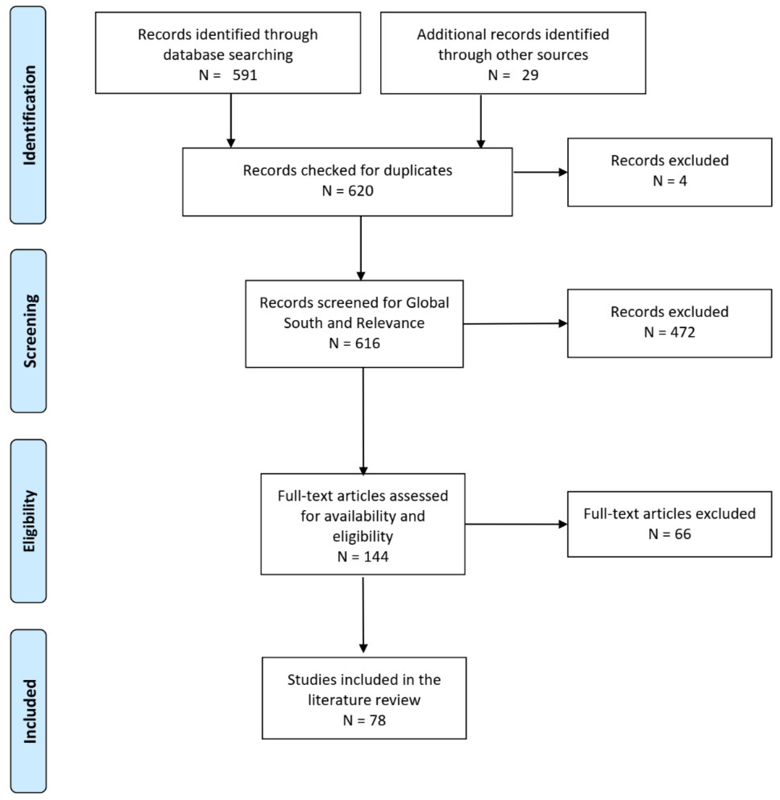
3.1. Literature Search

In this section, we adopt the PRISMA [33] method to search for the core literature used in this study. PRISMA (Figure 1) consists of the following steps: identification, screening, eligibility, and inclusion. We discuss each step below.
During the identification, we used the SCOPUS database to search for articles corresponding to our keywords. Based on the research objectives, keywords related to “crowdsourcing,” “urban planning,” and “Global South” should be identified (Table 1). Drawing from the discussion in Section 2, the main keywords related to “crowdsourcing” are VGI, PPGIS, PGIS, crowdsensing, etc. “Urban planning” was split into two keywords: “urban” (town, city, etc.) and “planning” (management, planning, and policy). The main difficulty was finding keywords related to “Global South,” as several studies do not have specific keywords for the GS. Instead, they use the name of the country or city in their abstract, title, or keywords. In order to include as many articles as possible, “Global South” was left out of the keywords and checked during the screening stage.
Using the keywords displayed in Table 1, we generated the following query:
TITLE-ABS-KEY ((crowd*sourc* OR “participatory sensing” OR crowd*sensing OR vgi
OR “volunteered geographic information” OR “participatory gis” OR
“participatory geographic information system*” OR “public participation
geographic information system*” OR *pgis OR “user*generated content”)
AND (urban OR residential OR city OR cities OR town)
AND (planning OR management OR policy OR policies))
AND (LIMIT-TO (SRCTYPE, “j”))
AND (LIMIT-TO (DOCTYPE, “ar”))
AND (LIMIT-TO (LANGUAGE, “English”))
The query above searches for journal articles written in English and corresponding to the keywords described in Table 1. The literature search was first performed in March 2021 and repeated in late December 2021 in order to find the latest articles. In total, 591 articles were obtained from SCOPUS. An additional 29 papers were obtained from other sources (references of selected papers and other reading materials), giving a total of 620 articles.
After removing the duplicates, the remaining articles were screened for relevance and geographic location. The articles corresponding to our research objectives and investigating cities of the GS were retained. A total of 144 articles were obtained at the end of this process.
The available articles from the remaining 144 were downloaded and checked for eligibility based on the following criteria. First, one of the main objectives of this study was to explore the crowdsourcing methods adopted in the GS and their associated challenges. Thus, only studies with a clearly detailed methodology were retained. Second, studies where the data were extracted without the knowledge of the users (social media scraping, non-voluntary crowdsensing, etc.) represented a large portion of the available literature and had to be removed manually. Using the aforementioned criteria, we further screened the database and obtained a final core literature of 78 papers (see Supplementary Materials). The following section provides the descriptive statistics of the reviewed papers.

3.2. Descriptive Statistics

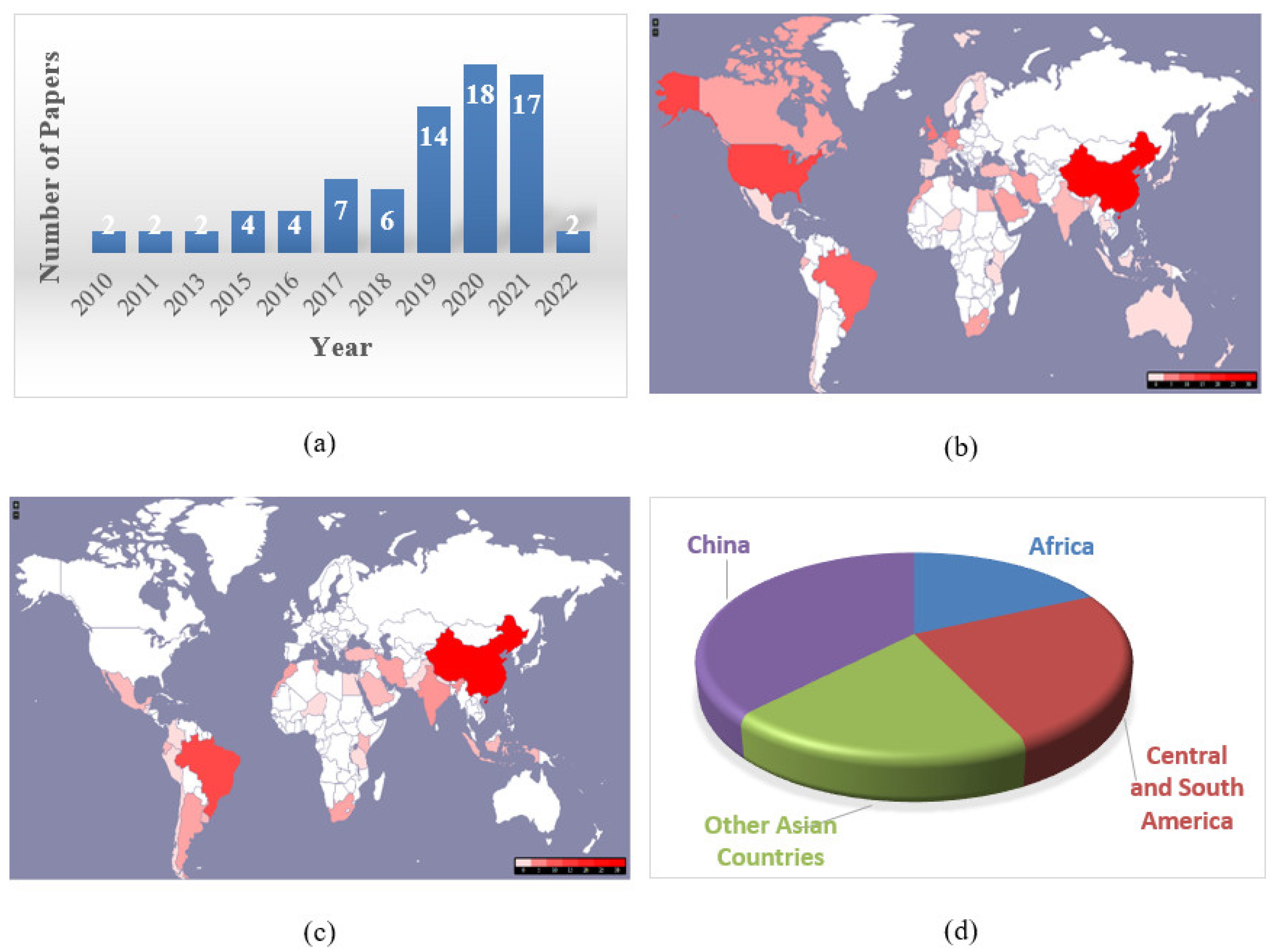
3.2.1. Source Titles and Article Frequency

Table 2 shows that the most represented journals are Remote Sensing (6 articles), Sustainability (5), IEEE Access, Cities, and the International Journal of Geographical Information Science (3). Sustainability, IEEE Access, and PloS One are all Open Access (OA) journals. Furthermore, 25 out of the 78 papers were published in OA journals (about 32%). More OA journals are needed as most researchers in the GS cannot afford journal subscriptions. Open Access journals would be a good way to democratize access to the latest findings and methods in this research area.
There are also many GIS/engineering journals, which may seem surprising. Given the research topic, one may expect more journals with a planning focus. However, several studies also tried to demonstrate how crowdsourcing could complement other methods, such as remote sensing, to solve the data scarcity problems of the GS [34]. These studies may target non-planning journals such as Remote Sensing Furthermore, several studies tried to optimize the crowdsourcing methods (through new incentive mechanisms, more privacy, better coverage, etc.) using advanced computer and engineering methods [35]. Such studies may target more engineering-oriented journals such as the IEEE series. The presence of GIS journals is mainly due to the fact that several crowdsourcing methods use VGI data (e.g., OSM, web-based PPGIS, etc.). However, all reviewed papers address important urban planning issues and could be of tremendous value for the GS.
All reviewed papers were published in the last 12 years, and the increasing numbers are evidence of a growing interest in the application of crowdsourcing methods in the GS (see Figure 2a).

3.2.2. Large Contribution from China and Researchers Outside the GS

Figure 2b shows that most of the research was conducted by researchers affiliated with Chinese institutes or those outside the GS (United States, United Kingdom, Germany, etc.). In terms of study areas (Figure 2c,d), 38% of the research was conducted in China, followed by 25% in Central and South America (Brazil, Argentina, Guatemala, etc.), 19% in the other parts of Asia (India, Iran, Pakistan, etc.), and 18% in Africa (South Africa, Egypt, Morocco, etc.). There was no contribution from the Pacific Islands.
These numbers show the large domination of China in this research field (both in terms of affiliations and study area). Meanwhile, the other areas of the GS are largely covered by researchers outside the region.

3.2.3. Research Areas

Table 3 shows the main research areas covered in the reviewed papers. We can see that urban morphology and transportation are the most represented areas (16 papers each), followed by environmental monitoring (13 papers). Papers that demonstrate the potential of crowdsourcing as a data collection method, as well as techniques to optimize it and those that assess crowdsourcing tools/methods, represent an important portion of the reviewed papers (9 papers each). Other areas such as urban demographics, disaster detection and management, and smart city management are also covered. The next section provides a detailed description of the main research areas and their key aspects.

4. Main Research Areas and Keys Aspects

In this section, we use Table 3 to describe the main areas and key aspects covered in the reviewed papers.

4.1. Urban Morphology

These studies use data shared by the public to examine the urban forms, their formation, and evolution, as well as their impact on different aspects of urban life. The main elements of urban forms investigated in the reviewed papers are land use, infrastructures, and housing. The GS experiences fast urbanization which negatively affects the aforementioned elements, and strong measures need to be taken in order to overcome the challenges. In terms of land use, studies in the GS focused on the classification of functional zones so as to determine the main areas where human activities usually occur [36,37,38]. Such studies are important for the GS as they can help, among others, detect rapid urbanization and can therefore help better manage the existing resources. Crowdsourcing is, in this case, a source of training datasets for the classification algorithms. Regarding infrastructures, they should be a major domain of investigation due to the lack of basic infrastructure in many areas of the GS [39]. Some studies investigated the effects of the road network on cyclist behavior [40]. Studies on urban design focus on the effects of the urban landscape and street configuration on human activities and/or behavior. For example, Mohamed & Stanek [30] examined the effects of street configuration on sexual harassment, while other researchers analyzed the impact of the urban landscape on physical activities [41,42]. Such studies can help guide future urban design so as to build safer, more equitable, and healthier urban environments. Regarding housing, it has been a major cause of concern in the GS, mainly due to the lack of affordable housing and the proliferation of informal settlements. Sub-Saharan Africa has the highest proportion of slums in the world (50.2%), followed by Central and Southern Asia (48.2%) [43]. To tackle these challenges, some studies have involved the public in the mapping of informal settlements in the GS. However, they usually rely on the most basic forms of community mapping with paper drawings and limited sample sizes [44,45]. With the proliferation of smartphones in some parts of the GS, more advanced methods through crowdsourcing could help reach larger samples.

4.2. Urban Transportation

Due to its importance and several implications on different aspects of urban life, transportation is among the most represented areas among the reviewed papers (16 papers). The wide variety of domains covered also justifies the large number of papers in the reviewed literature. As a service designed for the public, transportation is heavily impacted by the way people behave through time and space as well as their response to different transportation-related services. Investigating travelers’ behavior could help understand their impact on the urban space (e.g., through their travel patterns) and help draw more data-driven policies to support better transportation planning in the GS. In some cities of the GS, crowdsourcing has been used to examine users’ travel behavior through travel patterns [46], route choice [47], travel behavior’s impact on congestion [48], etc. Travelers’ responses to mobility services as well as strategies to improve them were also investigated. Musakwa and Selala [49] used crowdsourced GPS data to investigate cycling patterns, while other studies developed multimodal or public transportation networks with crowdsourced data [50,51]. Other studies also focus on the traffic signal optimization [52], traffic density estimation [53], etc. Given the large number of social media users among young people, researchers have also looked for ways to involve the youth in transportation planning by crowdsourcing through dedicated social media pages.

4.3. Environmental Monitoring and Management

In an era of sustainable urban planning, research on how public engagement could foster the development of more sustainable cities has become a trend in some cities of the GS. This is also in line with the United Nations’ 2030 agenda for sustainable development goals (SDGs) regarding sustainable cities and communities [54], which supports the improvement of urban planning in participatory and inclusive ways. For this reason, researchers have leveraged the power of public engagement through crowdsourcing to monitor the environment and, in some cases, develop decision support systems for both the public and decision-makers. The proliferation of smartphones has made this process easier as smartphones can capture and share data without any technical knowledge from the users. This made possible the collaborative collection of noise data [55], air temperature from smartphone batteries [56,57], the reporting pollution of coastal zones [58], etc.

4.4. Data Collection and Optimization

These studies demonstrate the potential of crowdsourcing as a source of data for the GS as well as ways to optimize the data collection methods. For example, in China, several research efforts have developed new methods to increase the spatio-temporal coverage of voluntary crowdsensing tasks to obtain larger and more representative datasets while minimizing the cost and improving privacy. These methods include protecting participants’ privacy, increasing the coverage distribution of sensing tasks through incentive mechanisms [59], and enhancing data forwarding performance through cooperative data forwarding mechanisms [60,61]. Taking into consideration the characteristics of the GS, other studies showed different solutions to involve the public in data gathering and experiment design [62]. Recently, there has been a growing trend on the potential for crowdsourcing as a data collection method for monitoring sustainable development goals (SDGs) in the GS. Pateman et al. [63] provided a review on the use of citizen science for monitoring SDGs in low-and-middle-income countries, while Fraisl et al. [6] introduced a citizen science tool (Picture Pile) for monitoring SDGs.

4.5. Assessment of Crowdsourcing Methods for Urban Planning

Some studies have assessed crowdsourcing methods in the context of urban planning in the GS. Given the novelty of crowdsourcing in the GS, such studies are crucial when assessing its applicability and usefulness for cities in this part of the world. If most studies adopt a more objective approach using statistical evaluations (through the density, accuracy, nature of the crowd, etc.), others opt for a subjective method through users’ perceptions (perceived usefulness, perceived ease of use, perceived satisfaction, etc.). The objective assessments mainly focused on collaborative mapping and were conducted in China [64,65], Turkey [66], Kenya [67], as well as cities in Argentina and Uruguay [68], most of them focusing on OSM. Regarding the subjective assessments, Cilliers & Flowerday [69] investigated the subjective factors affecting the intention to use the Interactive Voice Response (IVR) system in South Africa, while Bugs et al. [70] examined the perceived ease of use, perceived usefulness, and satisfaction with a Web-based PPGIS platform for urban planning in Brazil.

4.6. Smart City Management

Smart cities put the public at the center of the planning process. Therefore, participatory approaches such as crowdsourcing play an important role as they allow the public to share their ideas and opinions for more efficient planning practices. However, the GS is behind the rest of the world in terms of smart city management due to a lack of basic infrastructure and a clear understanding of what a smart city should be in local contexts. For this reason, crowdsourcing could start with an exchange on steps towards smart city transformation in the context of the GS. This is the method adopted by Kumar et al. [29], who crowdsourced ideas (idea generation) for smart city transformation in India. Another step would be to consult the public on the efficient management of the existing resources, as demonstrated by other studies in the GS [71].

4.7. Urban Demographics

The rapid population growth in many cities of the GS, especially African cities, raises some challenges which could be mitigated with data-driven methods. Such methods could help monitor the changes in the population, predict future trends and implement proactive policies to face future challenges. However, despite the potential advantages for the GS, urban population estimation has not been widely investigated in the area as all reviewed studies were conducted in China [72,73,74,75]. In the aforementioned studies, crowdsourcing (collaborative mapping through OSM) was adopted as supplementary open data so as to improve the accuracy of the mapping algorithms.

4.8. Disaster Detection and Management

If natural disasters are common in all regions of the world, the GS is particularly vulnerable to them due to the lack of resources for disaster detection and management. Crowdsourcing, especially collaborative mapping, has played an important role in helping the GS face these challenges. One of the main examples is the use of OSM for disaster relief during the 2010 earthquake in Haiti. Some studies have shown how public engagement can help improve flood mapping in the GS ([76,77,78]. Crowdsourced data can supplement other datasets (e.g., wireless sensor networks data) to develop spatial decision support systems (SDSS) for flood management, as demonstrated by Horita et al. [78].

4.9. Other Areas

Some research areas that could have tremendous effects on urban planning have not been widely investigated in the reviewed papers. Although lack of security is often an issue in the GS, only one study has addressed it among the reviewed papers [79]). This is also the case for urban tourism, urban governance, and facility location selection.
Several studies that were excluded also discussed different aspects of urban planning using social media data. As we explained in Section 2, social media without explicit consent from the crowd are excluded from the reviewed literature. The topics discussed in those studies include urban health (e.g., COVID mapping in urban areas), urban tourism, disaster detection and management (earthquake, flood detection, etc.).

5. Crowdsourcing Methods

This section provides an overview of the crowdsourcing methods applied in the GS. More specifically, for each method, we discuss the basic principles, its potential value for urban planning, especially in the context of the GS, the type of data obtained and, finally, its main areas of application. The methods identified in this study can be regrouped into three categories: collaborative websites, voluntary crowdsensing, and dedicated social media campaigns.

5.1. Collaborative Websites

Collaborative websites are web-based platforms that allow participants to share local knowledge, maps, geo-tagged pictures, etc., within a specific framework. Globally, they have the benefit of providing a participatory planning process that allows the end users to comment on planning projects [70], map the areas they are most familiar with (e.g., OSM), report violations and crimes [80], suggest innovative ideas for smart city planning [23], etc. Collaborative websites are generally in line with the concept of collective intelligence [81], as individual knowledge is openly available to other participants who can access, edit, discuss and improve them. As a result, they yield better outcomes than knowledge from single individuals. In the GS, government agencies usually lack the equipment and workforce to adequately handle the many problems they face on a daily basis [58,80]. Collaborative websites can provide a low-cost and effective solution to these problems while raising awareness among the people.
For more clarity, we distinguish between mapping as a separate endeavor and providing user-generated content to support a specific area of planning (crime reporting, environmental monitoring, etc.) using web-based PGIS/PPGIS, for example. This is because some maps are collaboratively built for general purposes (e.g., OSM). The resulting map could then be applied to different areas, including urban planning. The next subsection discusses collaborative mapping as a separate endeavor.

5.1.1. Collaborative Mapping

Collaborative mapping is a collective effort in which volunteers with various levels of expertise and motivations participate in the creation, edition, and dissemination of digital maps [27,82]. The mapping process relies on the collection (through sensors), assemblage, and annotation of geographic information using web mapping tools (e.g., OSM website). Since these web mapping tools are easy to use, even non-experts can take part in collaborative mapping, which helps reach a potentially larger crowd.
These mapping endeavors have several potential advantages for the GS, including accessibility and accuracy. Accessibility refers to the possibility for any user to freely use the maps. OSM provides this possibility as long as the user acknowledges their use of the service [82]. Furthermore, many areas of the GS still use outdated maps due to the costliness of professional mapping services [67]. Collaborative platforms offer the same level of accuracy as commercial mapping services [83]. These factors make collaborative mapping a potential source of reliable and up-to-date urban data with minimal cost for areas with limited resources, such as the GS.
The main data used from collaborative mapping in the GS consists of road networks (road types, stations, etc.) [47,84,85]. Datasets related to building footprint have also been used [86]. Collaborative mapping has been used to investigate urban morphology [40], land use [84,87], transportation planning [47,50], urban population estimation [74], etc. Recently, there has been an increasing trend in the contributions of corporate editors to OSM, especially in Southeast Asia [88]. Finally, it is worth noting that some collaborative mapping platforms also apply to specific areas such as disaster relief, election monitoring, etc. One example of such platforms in the GS is the use of the Ushahidi platform for flood mapping in Brazil [77].

5.1.2. Web-Based PPGIS

A web-based PPGIS framework consists of four main concepts: GIS, public participation, web development, and the domain of application (e.g., crime monitoring, environmental monitoring, flood mapping, etc.). As such, it is a multidisciplinary area that allows participants to share local knowledge through online GIS platforms. Participants can use the platform to post or comment on different urban problems, including infrastructure damage, crime, natural disasters, etc. The importance of the aforementioned problems and the risk they could represent in a community are among the main factors that explain the need for the public to actively participate in these PPGIS projects. Furthermore, artificial sensors (i.e., cameras), which are often used to monitor crime and other types of violations do not have the intelligence to provide an in-depth and real-time interpretation of the events. In this case, the public could provide a better response to the issue (e.g., crime reporting, helping the victim, etc.) than an artificial sensor. The posts can be in the form of geotagged text, audio, video, or a combination. The fact that other participants can also comment on a post helps ensure the reliability of the information provided.
Web-based PPGIS has been adopted in the GS for environmental monitoring [58], housing [89], crime management and monitoring [79], flood risk management [78], etc. There are also bottom-up decision support systems that allow the public to get involved throughout the decision-making process. In Iran, the web-based Spatial Decision Support System (WebGIS-SDSS) allows citizens to access, discuss, review and submit their opinions about urban development applications based on multi-criteria decision-making [90]. The authorities then aggregate the opinions to make their final decision (accept or reject the application).

5.1.3. Idea Generation/Idea Contest

Some collaborative websites provide a platform for innovative ideas to support modern and sustainable city planning. They allow non-experts to actively participate in the planning process by identifying their needs, submitting innovative ideas, commenting and/or rating other users’ suggestions [23], or helping choose the location of future facilities. Unlike collaborative mapping and web-based PPGIS, these websites do not necessarily require the use of geo-location services, and users can directly participate without any prior GIS knowledge. Despite its potential advantages for citizen empowerment, this type of collaborative website was rare among the reviewed papers. Examples in the GS include idea generation for smart city transformation in India [29] and facility location selection [91].

5.2. Voluntary Crowdsensing

The latest smartphones are equipped with a variety of sensors, including cameras, accelerometers, microphones, a global positioning system (GPS), air quality sensors, etc. Furthermore, there have been tremendous improvements in the memory size and computational capabilities of these mobile devices in the last few years. These factors, coupled with the increasing accessibility of smartphones, have turned mobile phone owners from simple users to contributors of rich sensing data. In addition to smartphones, these sensors can also be installed in other devices (laptops, tablets, etc.) or locations such as cars and help gather data for traffic or environmental monitoring from a potentially large group of participants. Crowdsensing uses the power of the crowd and the ubiquity of sensing technologies to collect data for various urban planning activities, including traffic management, environmental monitoring, etc.
Crowdsensing has advantages in investigating modes with low share, such as cycling. Given the small number of cyclists in many cities (between 1 and 2% for work trips), it may be difficult to find a representative sample for analyzing cycling patterns using traditional methods such as cycle count [92]. In this case, crowdsensing could help cover a larger and more diverse sample (e.g., Strava in Johannesburg, South Africa [49]). Crowdsensing is also beneficial in traffic control and management. It could be a time and cost-efficient alternative to roadside cameras and loop detectors to detect traffic congestion. Most developing countries cannot afford these cameras or other roadside sensors and could highly benefit from these methods [52]. In Africa, recent studies have used GPS devices to address the lack of reliable data [93,94]. However, these methods are expensive and suffer from a limited sample size [93,94]. Crowdsensing could provide a low-cost solution to these problems [95].
Data from crowdsensing usually consists of GPS tracks, temperature, noise level, particulate matter (PM2.5 and PM10), geotagged pictures/videos/audio/comments shared by participants, etc. Crowdsensing can also provide large urban datasets for planners. Examples of such datasets in the GS include datasets for environmental sensing [55,57], GPS data for cycling patterns analysis [49]), and smart city management [96], Waze data for urban mobility [48], etc.
As specified in Section 2, we only investigated voluntary participation in crowdsensing throughout our analysis.

5.3. Dedicated Social Media Campaigns

Social media campaigns (SMC) are not to be confused with social media scraping (through Twitter or Weibo). By SMC, we refer to specific social media pages, groups, etc. which are launched with a clear goal (e.g., addressing an urban planning issue), the task is clearly defined and outsourced to the crowd (submission of proposals, comments, complaints, vote, etc.), and the participation is always voluntary. They are, to some extent, similar to collaborative websites. However, unlike many collaborative websites which require technical skills and/or financial resources (that are not always available in the GS), SMC leverage existing social media platforms and are easy to set up and manage. A concrete example would be the use of a dedicated Facebook group to discuss public safety in an urban area. The crowdsourcer can launch a page that invites all inhabitants of a specific area to report issues, comment, and suggest solutions. The information provided could be valuable to policymakers and the public without any financial burden.
Examples of applications in the GS include Facebook pages for public participation in transportation planning [97] and e-government [98], sexual harassment reporting on Facebook and Twitter [30], etc.

6. Discussion

6.1. Challenges

Although some challenges, such as sample representativeness, privacy, access, and data processing, are applicable to all crowdsourcing projects [99], some issues are specific to or more severe in the GS. The challenges discussed here are drawn from the characteristics of the GS and corroborated with the 78 reviewed papers.

6.1.1. The Digital Divide

Despite the recent improvements, the digital divide is still present in many parts of the world [63]. The GS is also characterized by a technological gap with respect to the rest of the world. For example, in 2022, Internet penetration rates are lower in Africa (43.2%), The Caribbean/South America (80.5%), the Middle East (77.1%) and Asia (67.0%) [100]. In comparison, North America has a 93.4% penetration rate, while 89.2% of Europeans have access to the Internet. Furthermore, access to mobile Internet is also lower in low and middle-income countries [101]. Given the importance of the Internet in crowdsourcing, the GS suffers a severe disadvantage compared with the rest of the world. In addition to access, the ability to use the technology is also an indicator of the digital divide. A lack of literacy and digital skills is a barrier to mobile Internet use in low-and-middle-income countries [101]. As a result, many people lack the knowledge or means to effectively handle the technology needed to participate in collaborative mapping [27] or web-based planning decision support systems. This is evidenced by Young et al. [102], whose crowdsourcing effort across Africa was hindered by slow and expensive Internet connections, regular disruptions due to power outages, and participants’ limited digital skills. Zia et al. [66] also found a strong correlation between literacy level and the density of OSM in Turkey. Thus, the digital divide could lead to limited mapping coverage and/or reliance on armchair mappers. Despite their efforts, armchair mappers lack local knowledge, which can have significant effects on the accuracy of the produced maps. De Leeuw et al. [67] found that participants with local knowledge (including laypeople) achieved significantly higher accuracies than those without local knowledge, including professional mappers.

6.1.2. Academic Challenges and Digital Colonialism

Figure 2b shows that, besides China, most of the studies were conducted by researchers outside the GS. The possible reasons for the limited numbers of researchers from the GS (besides China) are a lack of access to the technologies (see Section on digital divide), limited resources for undertaking data collection campaigns, and a lack of trained experts able to process the data. For these reasons, countries of the GS are at the mercy of NGOs, funding agencies, and institutes of the Global North whose interests may not be aligned with the challenges faced by cities of the GS. This predominance of foreign entities could be an opportunity if they fully involved their local counterparts in the process. However, since foreign institutes and NGOs also provide the funding, their collaboration with local scholars usually turns into a top-down relationship where local researchers are merely used as “glorified data collectors” [103]. This hierarchical relationship affects the way research is conducted in the GS and could leave out important issues that affect the local people. For example, a few studies among the reviewed literature address issues related to public safety (e.g., crime mapping), illegal dumping, gender-related issues, or lack of basic facilities and services in many GS cities (e.g., good roads, poor public transportation systems, etc.). Beyond the academic area, this also raises several questions about the possible “exploitation” of the GS citizens whose efforts to contribute data to crowdsourcing campaigns may only serve the interests of foreign (usually Global North) organizations. Do the data contributed result in solutions that help the participants? Do the participants have access to the data they contributed? Do these external scholars and NGOs give an accurate and unbiased portrayal of the Global South? All these issues have raised concerns over new forms of “digital and data colonialism” [102,104]. Moreover, the growing influence of corporate editors [88] could be problematic, especially in the vulnerable areas of the GS, if the generated maps serve corporate interests rather than the local people. Digital colonialism poses challenges to citizen empowerment, data ownership, and academic excellence. If these challenges are not addressed, they could contribute to enforcing the same North-South inequalities that democratic processes such as crowdsourcing were supposed to mitigate.
It is important to clarify that we did not see any direct relationship between a particular crowdsourced method and the former colonial ruler. This is due to the fact that the crowdsourcing projects are usually launched by different Western organizations regardless of who the former colonial power was. For example, a project in Niger (a former French colony) was initiated by a German organization [105]). Another project in Mexico (a former Spanish colony) was initiated by a Belgian organization [62]. All these projects have certain characteristics in common.
  • Besides China, most projects were initiated by foreign, western universities, an indication of dependence on western countries for crowdsourcing.
  • Such dependence has implications in terms of data ownership, research design, and administration (as we explained in Section 6), which lead to the phenomenon of digital colonialism.
Thus, digital colonialism is not necessarily associated with a particular former colonial ruler; it is due to the presence and practices of western organizations whose control over the data may not serve the interests of the local communities.
It is, however, important to point out that digital colonialism’s impact on the global south varies depending on the region. As shown in Figure 2b, China is less dependent on foreign researchers.

6.1.3. Socio-Economic and Cultural Challenges

The issues raised here are related to income, age, and gender.
Regarding age and income, about 25% of adults in low-and-middle-income countries are unaware of mobile Internet, while more than half of the people do not meet the UN’s mobile Internet affordability target [101]. Lack of awareness and/or affordability of mobile Internet is an obstacle to people’s participation in mobile crowdsourcing and a source of bias. The potential cultural issues are mostly related to gender. Gender issues in the GS include the assumption in many cultures that women lack the ability to provide useful information in mapping projects, for example [106]. Furthermore, women from low-and-middle-income countries are 20% less likely than men to use mobile Internet. Since one of the main objectives of crowdsourcing is to democratize the planning process and empower the public, all stakeholders need to actively and freely participate regardless of gender. In addition, crowdsourcing could help address many of the problems (primarily) faced by women, such as sexual harassment. One example of such a case in the GS is HarassMap, a platform for reporting sexual harassment in Egypt. Although such platforms could help raise awareness and encourage the authorities to address this issue, the authors also pointed out the lack of female participation as a major challenge [30]. Another cultural challenge in the GS is the expectation of financial reward in exchange for participation, even when the project has clear value for the community [102]. This could seriously limit the number of participants as many citizen engagement projects do not offer any financial reward.

6.1.4. Administrative Challenges

Public participation should integrate the input of all stakeholders into the planning process. In this regard, citizens should not be simple providers of census data or travel diaries, nor should their role be limited to a simple consultation prior to decision making. Instead, they should be involved throughout the decision-making process. However, the GS is mostly characterized by top-down governance systems, which give little to no room for full citizen participation [90]. This is also evidenced in the literature corpus analyzed in this study, where a few studies provide platforms for citizen participation in problem-solving or decision-making.
The existence of top-down governance systems also does not allow to break away from traditional authoritative data collection methods. Many projects often seek approval from local authorities before implementation [102].

6.2. Suggestions for Future Implementations

6.2.1. Data Ownership and Benefits for the Public: A Solution to Digital Colonialism and Low Participants’ Motivation

It is important for the public to know that their efforts to collect and/or share data/information will be accessible to them, or they will result in solutions, technologies, or policies that will help them, not exploit them. A failure to meet the aforementioned requirements could further reinforce digital colonialism and affect the public’s motivation to participate in any crowdsourcing initiative [102]. In the GS, some scholars address this issue by looking for ways to help the public directly appropriate their data and/or participate in the interpretation of the results. For example, in Niamey (Niger, Africa), participants and their families were also involved in the analysis and interpretation of the crowdsourced photos [105]. In China, Li et al. [55] stated that data shared by the public through their collaborative environmental sensing network (CESN) would be publicly available, which could increase the number of participants. Unlike Strava Metro, which is a commercial platform, OSM data is available to the public. Thus, participants in OSM projects can directly access the fruit of their labor and use it for future endeavors. This makes OSM more suitable for the GS than other commercial services. Experts should also use the data contributed by the public to develop solutions that will benefit them. In Kenya, Williams et al. [107] used the data collected through the digital Matatu project to help local experts build a mobile crowdsourcing application (Ma3Route), which shares real-time traffic data with users [108]. In Morocco, El Alaoui El Abdallaoui et al. [109] designed an air quality decision support system that uses collaborative environmental sensing data to recommend the least polluted route and display information pertaining to public health. Finally, it is important to get participants more involved in the design of the methodologies. This could help design methods that are more suitable for the participants and ensure that the projects’ goals are in line with community priorities [63]. An example is provided in Mexico, where participants and experts codesigned the crowdsourcing experiment for SenseCityVity [62].

6.2.2. For Governments and Research Institutes

In addition to the public, digital colonialism also affects local scholars. Crowdsourcing could be an opportunity for strong collaboration between North-South researchers if challenges related to digital and data colonialism are addressed. To do so, a new framework that integrates equal inputs from both sides is needed. More concretely, local researchers should not be “exploited” for data collection. Instead, they should fully participate in the definition of the objectives and methodology so that the research is in line with the needs of the GS and does not repeat the same North-South inequalities that characterize digital and data colonialism.
This review has shown that there is an urgent need for more research in many areas. The Caribbean, Central America, the Pacific Islands, the Middle East, and Sub-Saharan Africa are barely covered, with the research largely condensed in China and Brazil. This opens an opportunity for more research and perhaps more insight into the urban dynamics of this area of the world that remains unknown. Furthermore, as discussed in Section 4, several topics have not been widely investigated despite their importance for the GS and the potential benefits of public engagement in these areas. This shows the tremendous potential that is yet to be fulfilled in the application of crowdsourcing for urban studies in the GS.
For governments, it is important to include public participation in all aspects of their programs to raise awareness and encourage citizen engagement. A good example in the GS is Brazil, which encourages public engagement via legislation [70]. This seems to have a major effect as a large part of the platforms for public engagement were found in Brazil [70,71,77,78,110].
Finally, authorities, as well as researchers, should adopt more affordable methods such as open-source software (which allows access and replication of the methods) [111], as well as accessible and easy-to-use platforms such as Ushahidi (https://www.ushahidi.com/about/pricing, accessed on 9 May 2022). Since most crowdsourcing projects are not sustained due to a lack of resources, these solutions could be useful to the GS.

6.2.3. Solutions to Socio-Economic and Cultural Challenges

Sample representativeness is a challenge in all crowdsourced projects. The problem is bigger in the GS, where some segments of the population are excluded due to local customs (see Section 6.1.3). Including all members of the society helps mitigate sample bias and provide a more accurate analysis of the problem under study, which in turn helps implement more suitable policies. A change of mentality (especially regarding women) is required. Another way to include women is to adapt the public engagement process to their temporal and spatial constraints, for example, by allowing them to participate with their children [63].
Other solutions to socio-economic and cultural barriers include using emojis, pictures, checkmarks, and voice messages to reach the illiterate [63,69,111]. An interesting example in the GS would be the adoption of the interactive voice response (IVR) system in South Africa [69]. The IVR is a crowdsourcing system that allows users to report public safety concerns by directly recording and sharing a voice message without having the write or deal with a web interface. Furthermore, the IVR system can be available through a toll-free number (accessible to the poor) and be adapted to local languages.
Finally, the use of mixed methods is also important. This includes combining crowdsourcing with traditional methods to obtain more representative samples. For example, in areas with low literacy levels, the project could involve calling, chatting on social media platforms (WhatsApp, for example), and having personal meetings with the participants in order to explain in detail the basics of the participation process [102] or combining the crowdsourced data with census data.

7. Conclusions

Although crowdsourcing has several advantages, it is important for planners to have a clear understanding of the target population [15]. This could help anticipate some of the challenges that could affect the quality of the crowdsourced data. Given the unique characteristics of the GS, it was thus crucial to conduct a review of the crowdsourcing methods adopted in this region of the world and highlight their potential benefits and challenges so as to provide some suggestions for future research.
To achieve this goal, we reviewed 78 English-written journal articles focusing on voluntary participation in crowdsourcing in the GS. The reviewed articles were mainly contributed by researchers affiliated with Chinese institutes or outside the GS. Among the crowdsourcing methods, collaborative mapping (through OSM) was most widely adopted, while the studies covered a variety of areas, including urban transportation, event detection and crisis management, urban tourism, urban health, environmental monitoring, gender, etc. Based on the descriptive statistics of the reviewed papers and the characteristics of the GS, we discussed the potential administrative, academic, technological, socio-economic, and cultural challenges that could affect the successful adoption of crowdsourcing in the GS. Solutions to these challenges were provided as suggestions for future implementations and included new collaboration frameworks with foreign experts so as to avoid digital colonialism, the inclusion of all segments of the population (especially women), the use of more accessible platforms to foster public participation in urban planning (e.g., Ushahidi), the development of methods that are more in line with the needs and the characteristics of the GS, etc.
Overall, this study has demonstrated that even though crowdsourcing has been heralded as a means for less developed countries to gather large urban data at a minimal cost and foster citizen empowerment and awareness through public platforms, several challenges still need to be addressed. The needed datasets and/or platforms are VGI (e.g., OSM) datasets to complement remote sensing datasets for investigating the challenges of the GS (e.g., informal settlements, lack of data for disaster response, crimes, lack of clean water, etc.), citizen sensing data for a better understanding of mobility patterns (e.g., GPS) and environmental monitoring (noise, temperature, etc.), recommendations/solutions for better planning practices, etc.
This study is, however, not without limitations. The inclusion of China in the literature could be misleading as a large portion of the reviewed papers is from this country. This might give the impression that the GS, in general, has produced a large part of the studies on this topic. The main reason for including China was the fact that, despite its rapid growth in the last four decades, the country still displays some characteristics of the GS [112]. Thus, its inclusion could help compare it with the rest of the GS and stress the progress that is to be made in order to perhaps reach the same standards in terms of innovation and academic achievements. Furthermore, although a careful and well-justified literature search was adopted, the small number of studies from French-speaking African countries and Latin America could be due to the fact that only articles written in English were included in the review. Given the large number of French-speaking countries in Africa and Spanish-speaking countries in Latin America, some valuable contributions could have been left out. English is, however, the language adopted in most studies and literature reviews [113], and we believe that reviewed articles offer a clear overview of the crowdsourcing methods adopted for urban planning in the GS as well as the associated challenges and our suggestions are expected to encourage more research in this area.

Supplementary Materials

The following supporting information can be downloaded at: https://www.mdpi.com/article/10.3390/su141811461/s1 File S1: List of Reviewed Papers.

Author Contributions

Conceptualization, E.B.D., J.C., S.C.K.T. and R.A.; methodology, E.B.D.; software, E.B.D.; validation, E.B.D., J.C., S.C.K.T. and R.A.; formal analysis, E.B.D.; data curation, E.B.D.; writing—original draft preparation, E.B.D.; writing—review and editing, E.B.D., J.C., S.C.K.T. and R.A.; supervision, J.C.; project administration, J.C. All authors have read and agreed to the published version of the manuscript.

Funding

This research received no external funding.

Data Availability Statement

The data presented in this study are available in File S1.

Conflicts of Interest

The authors declare no conflict of interest.

References

  1. Howe, J. The Rise of Crowdsourcing. Wired Mag. 2006, 41, 1–4. Available online: https://www.wired.com/2006/06/crowds/ (accessed on 9 May 2022).
  2. Toyota Global. Data: Changes in Toyota Trademarks and Emblems; Toyota Global: Toyota, Japan, 2012. [Google Scholar]
  3. Davidoff, P. Advocacy and Pluralism in Planning. J. Am. Inst. Plann. 1965, 31, 331–338. [Google Scholar] [CrossRef]
  4. UN ESCAP. Asia and the Pacifc SDG Progress Report 2020; United Nations: Bangkok, Thailand, 2020. [Google Scholar]
  5. Fraisl, D.; Campbell, J.; See, L.; Wehn, U.; Wardlaw, J.; Gold, M.; Moorthy, I.; Arias, R.; Piera, J.; Oliver, J.L.; et al. Mapping Citizen Science Contributions to the UN Sustainable Development Goals. Sustain. Sci. 2020, 15, 1735–1751. [Google Scholar] [CrossRef]
  6. Fraisl, D.; See, L.; Sturn, T.; MacFeely, S.; Bowser, A.; Campbell, J.; Moorthy, I.; Danylo, O.; McCallum, I.; Fritz, S. Demonstrating the Potential of Picture Pile as a Citizen Science Tool for SDG Monitoring. Environ. Sci. Policy 2022, 128, 81–93. [Google Scholar] [CrossRef]
  7. Njoh, A.J. The Experience and Legacy of French Colonial Urban Planning in Sub-Saharan Africa. Plan. Perspect. 2004, 19, 435–454. [Google Scholar] [CrossRef]
  8. United Nations. How Building Codes and Regulations Can Be Adapted to Meet the Basic Needs of the Poor: Report of the UN Seminar of Experts on Building Codes and Regulations in Developing Countries, Tällberg and Stockholm, March, 1980; Swedish Council for Building Research: Stockholm, Sweden, 1980; ISBN 91-540-3251-2. [Google Scholar]
  9. Chenal, J. Les Villes Africaines en Quête de Nouveaux Modèles Urbanistiques. Available online: https://metropolitiques.eu/Les-villes-africaines-en-quete-de.html (accessed on 10 January 2021).
  10. Insua, R.D.; Kersten, E.G.; Rios, J.; Grima, C. Towards Decision Support for Participatory Democracy. ISeB 2008, 6, 161–191. [Google Scholar] [CrossRef]
  11. Bai, S.; Jiao, J. From Shared Micro-Mobility to Shared Responsibility: Using Crowdsourcing to Understand Dockless Vehicle Violations in Austin, Texas. J. Urban Aff. 2020, 42, 1–13. [Google Scholar] [CrossRef]
  12. Thiagarajan, A.; Biagioni, J.; Gerlich, T.; Eriksson, J. Cooperative Transit Tracking Using Smart-Phones. In Proceedings of the 8th ACM Conference on Embedded Networked Sensor Systems, Zurich, Switzerland, 3–5 November 2010; pp. 85–98. [Google Scholar]
  13. De Filippi, F.; Coscia, C.; Boella, G.; Antonini, A.; Calafiore, A.; Cantini, A.; Guido, R.; Salaroglio, C.; Sanasi, L.; Schifanella, C. MiraMap: A We-Government Tool for Smart Peripheries in Smart Cities. IEEE Access 2016, 4, 3824–3843. [Google Scholar] [CrossRef]
  14. Hu, K.; Sivaraman, V.; Luxan, B.G.; Rahman, A. Design and Evaluation of a Metropolitan Air Pollution Sensing System. IEEE Sens. J. 2016, 16, 1448–1459. [Google Scholar] [CrossRef]
  15. Griffin, G.P.; Jiao, J. The Geography and Equity of Crowdsourced Public Participation for Active Transportation Planning. Transp. Res. Rec. 2019, 2673, 1–9. [Google Scholar] [CrossRef]
  16. Kemajou, A.; Konou, A.A.; Jaligot, R.; Chenal, J. Analyzing Four Decades of Literature on Urban Planning Studies in Africa (1980–2020). Afr. Geogr. Rev. 2021, 40, 425–443. [Google Scholar] [CrossRef]
  17. Kong, X.; Liu, X.; Jedari, B.; Li, M.; Wan, L.; Xia, F. Mobile Crowdsourcing in Smart Cities: Technologies, Applications, and Future Challenges. IEEE Internet Things J. 2019, 6, 8095–8113. [Google Scholar] [CrossRef]
  18. Kanhere, S.S. Participatory Sensing: Crowdsourcing Data from Mobile Smartphones in Urban Spaces. In Proceedings of the IEEE International Conference on Mobile Data Management, Lulea, Sweden, 6–9 June 2011; Volume 2, pp. 3–6. [Google Scholar]
  19. Niu, H.; Silva, E.A. Crowdsourced Data Mining for Urban Activity: Review of Data Sources, Applications, and Methods. J. Urban Plan. Dev. 2020, 146, 04020007. [Google Scholar] [CrossRef]
  20. Certomà, C.; Corsini, F.; Rizzi, F. Crowdsourcing Urban Sustainability. Data, People and Technologies in Participatory Governance. Futures 2015, 74, 93–106. [Google Scholar] [CrossRef]
  21. Criscuolo, L.; Carara, P.; Bordogna, G.; Pepe, M.; Zucca, F.; Seppi, R.; Ostermann, F.; Rampini, A. Handing Quality in Crowdsourced Geographic Information.; Ubiquity Press Ltd.: London, UK, 2016. [Google Scholar]
  22. Wang, X.; Zheng, X.; Zhang, Q.; Wang, T.; Shen, D. Crowdsourcing in ITS: The State of the Work and the Networking. IEEE Trans. Intell. Transp. Syst. 2016, 17, 1596–1605. [Google Scholar] [CrossRef]
  23. Schuurman, D.; Baccarne, B.; De Marez, L.; Mechant, P. Smart Ideas for Smart Cities: Investigating Crowdsourcing for Generating and Selecting Ideas for ICT Innovation in a City Context. J. Theor. Appl. Electron. Commer. Res. 2012, 7, 49–62. [Google Scholar] [CrossRef]
  24. Estellés-Arolas, E.; González-Ladrón-De-Guevara, F. Towards an Integrated Crowdsourcing Definition. J. Inf. Sci. 2012, 38, 189–200. [Google Scholar] [CrossRef]
  25. Brabham, D.C. Crowdsourcing the Public Participation Process for Planning Projects. Plan. Theory 2009, 8, 242–262. [Google Scholar] [CrossRef]
  26. Kumar, H.; Singh, M.K.; Gupta, M.P. Smart Mobility: Crowdsourcing Solutions for Smart Transport System in Smart Cities Context. In Proceedings of the 11th International Conference on Theory and Practice of Electronic Governance, Galway, Ireland, 4–6 April 2018; pp. 482–488. [Google Scholar]
  27. Heipke, C. Crowdsourcing Geospatial Data. ISPRS J. Photogramm. Remote Sens. 2010, 65, 550–557. [Google Scholar] [CrossRef]
  28. Nakatsu, R.T.; Grossman, E.B.; Iacovou, C.L. A Taxonomy of Crowdsourcing Based on Task Complexity. J. Inf. Sci. 2014, 40, 823–834. [Google Scholar] [CrossRef]
  29. Kumar, H.; Singh, M.K.; Gupta, M.P.; Madaan, J. Moving towards Smart Cities: Solutions That Lead to the Smart City Transformation Framework. Technol. Forecast. Soc. Chang. 2020, 153, 119281. [Google Scholar] [CrossRef]
  30. Mohamed, A.A.; Stanek, D. The Influence of Street Network Configuration on Sexual Harassment Pattern in Cairo. Cities 2020, 98, 102583. [Google Scholar] [CrossRef]
  31. Guo, B.; Yu, Z.; Zhou, X.; Zhang, D. From Participatory Sensing to Mobile Crowd Sensing. In Proceedings of the 2014 IEEE International Conference on Pervasive Computing and Communication Workshops, Percom Workshops, Budapest, Hungary, 24–28 March 2014; pp. 593–598. [Google Scholar]
  32. Nummi, P. Crowdsourcing Local Knowledge with PPGIS and Social Media for Urban Planning to Reveal Intangible Cultural Heritage. Urban Plan. 2018, 3, 100–115. [Google Scholar] [CrossRef]
  33. Moher, D.; Liberati, A.; Tetzlaff, J.; Altman, D.G. Preferred Reporting Items for Systematic Reviews and Meta-Analyses: The PRISMA Statement. PLoS Med. 2009, 6, e1000097. [Google Scholar] [CrossRef] [PubMed]
  34. Forget, Y.; Shimoni, M.; Gilbert, M.; Linard, C. Mapping 20 Years of Urban Expansion in 45 Urban Areas of Sub-Saharan Africa. Remote Sens. 2021, 13, 525. [Google Scholar] [CrossRef]
  35. Yu, Z.; Han, L.; An, Q.; Chen, H.; Yin, H.; Yu, Z. Co-Tracking: Target Tracking via Collaborative Sensing of Stationary Cameras and Mobile Phones. IEEE Access 2020, 8, 92591–92602. [Google Scholar] [CrossRef]
  36. Liu, X.; He, J.; Yao, Y.; Zhang, J.; Liang, H.; Wang, H.; Hong, Y. Classifying Urban Land Use by Integrating Remote Sensing and Social Media Data. Int. J. Geogr. Inf. Sci. 2017, 31, 1675–1696. [Google Scholar] [CrossRef]
  37. Ye, Y.; An, Y.; Chen, B.; Wang, J.J.; Zhong, Y. Land Use Classification from Social Media Data and Satellite Imagery. J. Supercomput. 2020, 76, 777–792. [Google Scholar] [CrossRef]
  38. Xing, H.; Meng, Y. Integrating Landscape Metrics and Socioeconomic Features for Urban Functional Region Classification. Comput. Environ. Urban Syst. 2018, 72, 134–145. [Google Scholar] [CrossRef]
  39. Dempsey, N.; Brown, C.; Raman, S.; Porta, S.; Jenks, M.; Jones, C.; Bramley, G. Elements of Urban Form. In Dimensions of the Sustainable City; Jenks, M., Jones, C., Eds.; 2008; pp. 21–51. ISBN 9781402086472. [Google Scholar]
  40. Orellana, D.; Guerrero, M.L. Exploring the Influence of Road Network Structure on the Spatial Behaviour of Cyclists Using Crowdsourced Data. Environ. Plan. B Urban Anal. City Sci. 2019, 46, 1314–1330. [Google Scholar] [CrossRef]
  41. Ma, M.; Ding, L.; Kou, H.; Tan, S.; Long, H. Effects and Environmental Features of Mountainous Urban Greenways (MUGs) on Physical Activity. Int. J. Environ. Res. Public. Health 2021, 18, 8696. [Google Scholar] [CrossRef]
  42. Liu, K.; Siu, K.W.M.; Gong, X.Y.; Gao, Y.; Lu, D. Where Do Networks Really Work? The Effects of the Shenzhen Greenway Network on Supporting Physical Activities. Landsc. Urban Plan. 2016, 152, 49–58. [Google Scholar] [CrossRef]
  43. Statista Share of Urban Population Living in Slums in 2020, by Region. Available online: https://www.statista.com/statistics/684694/percentage-of-world-urban-population-in-slums-by-region/ (accessed on 1 August 2022).
  44. Panek, J.; Sobotova, L. Community Mapping in Urban Informal Settlements: Examples from Nairobi, Kenya. Electron. J. Inf. Syst. Dev. Ctries. 2015, 68, 1–13. [Google Scholar] [CrossRef]
  45. Vergara-Perucich, F.; Arias-Loyola, M. Community Mapping with a Public Participation Geographic Information System in Informal Settlements. Geogr. Res. 2021, 59, 268–284. [Google Scholar] [CrossRef]
  46. Pedreira Junior, J.U.; Assirati, L.; Pitombo, C.S. Improving Travel Pattern Analysis with Urban Morphology Features: A Panel Data Study Case in a Brazilian University Campus. Case Stud. Transp. Policy 2021, 9, 1715–1726. [Google Scholar] [CrossRef]
  47. Wu, T.; Zeng, Z.; Qin, J.; Xiang, L.; Wan, Y. An Improved Hmm-Based Approach for Planning Individual Routes Using Crowd Sourcing Spatiotemporal Data. Sensors 2020, 20, 6938. [Google Scholar] [CrossRef]
  48. Calatayud, A.; Sánchez González, S.; Marquez, J.M. Using Big Data to Estimate the Impact of Cruise Activity on Congestion in Port Cities. Marit. Econ. Logist. 2022, 24, 566–583. [Google Scholar] [CrossRef]
  49. Musakwa, W.; Selala, K.M. Mapping Cycling Patterns and Trends Using Strava Metro Data in the City of Johannesburg, South Africa. Data Brief 2016, 9, 898–905. [Google Scholar] [CrossRef]
  50. Frez, J.; Baloian, N.; Pino, J.A.; Zurita, G.; Basso, F. Planning of Urban Public Transportation Networks in a Smart City. J. Univers. Comput. Sci. 2019, 25, 946–966. [Google Scholar]
  51. Smarzaro, R.; Davis, C.A.; Quintanilha, J.A. Creation of a Multimodal Urban Transportation Network through Spatial Data Integration from Authoritative and Crowdsourced Data. ISPRS Int. J. Geo-Inf. 2021, 10, 470. [Google Scholar] [CrossRef]
  52. Dixit, V.; Nair, D.J.; Chand, S.; Levin, M.W. A Simple Crowdsourced Delay-Based Traffic Signal Control. PLoS ONE 2020, 15, e0230598. [Google Scholar] [CrossRef] [PubMed]
  53. Huang, Y.; Tian, Y.; Liu, Z.; Jin, X.; Liu, Y.; Zhao, S.; Tian, D. A Traffic Density Estimation Model Based on Crowdsourcing Privacy Protection. ACM Trans. Intell. Syst. Technol. 2020, 11, 1–8. [Google Scholar] [CrossRef]
  54. United Nations Transforming Our World: The 2030 Agenda for Sustainable Development. Available online: https://sdgs.un.org/2030agenda (accessed on 30 August 2022).
  55. Li, C.; Wei, D.; Vause, J.; Liu, J. Towards a Societal Scale Environmental Sensing Network with Public Participation. Int. J. Sustain. Dev. World Ecol. 2013, 20, 261–266. [Google Scholar] [CrossRef]
  56. Overeem, A.; Robinson, J.C.R.; Leijnse, H.; Steeneveld, G.J.; Horn, B.K.P.; Uijlenhoet, R. Crowdsourcing Urban Air Temperatures from Smartphone Battery Temperatures. Geophys. Res. Lett. 2013, 40, 4081–4085. [Google Scholar] [CrossRef]
  57. Droste, A.M.; Pape, J.J.; Overeem, A.; Leijnse, H.; Steeneveld, G.J.; Van Delden, A.J.; Uijlenhoet, R. Crowdsourcing Urban Air Temperatures through Smartphone Battery Temperatures in São Paulo, Brazil. J. Atmos. Ocean. Technol. 2017, 34, 1853–1866. [Google Scholar] [CrossRef]
  58. Fatehian, S.; Jelokhani-Niaraki, M.; Kakroodi, A.A.; Dero, Q.Y.; Samany, N.N. A Volunteered Geographic Information System for Managing Environmental Pollution of Coastal Zones: A Case Study in Nowshahr, Iran. Ocean Coast. Manag. 2018, 163, 54–65. [Google Scholar] [CrossRef]
  59. Xu, S.; Chen, X.; Pi, X.; Joe-Wong, C.; Zhang, P.; Noh, H.Y. ILOCuS: Incentivizing Vehicle Mobility to Optimize Sensing Distribution in Crowd Sensing. IEEE Trans. Mob. Comput. 2020, 19, 1831–1847. [Google Scholar] [CrossRef]
  60. Ren, Y.; Wang, T.; Zhang, S.; Zhang, J. An Intelligent Big Data Collection Technology Based on Micro Mobile Data Centers for Crowdsensing Vehicular Sensor Network. Pers. Ubiquitous Comput. 2020, 1–7. [Google Scholar] [CrossRef]
  61. Rahim, A.; Ma, K.; Zhao, W.; Tolba, A.; Al-Makhadmeh, Z.; Xia, F. Cooperative Data Forwarding Based on Crowdsourcing in Vehicular Social Networks. Pervasive Mob. Comput. 2018, 51, 43–55. [Google Scholar] [CrossRef]
  62. Ruiz-Correa, S.; Santani, D.; Ramírez-Salazar, B.; Ruiz-Correa, I.; Rendón-Huerta, F.A.; Olmos-Carrillo, C.; Sandoval-Mexicano, B.C.; Arcos-Garcia, Á.H.; Hasimoto-Beltrán, R.; Gatica-Perez, D. SenseCityVity: Mobile Crowdsourcing, Urban Awareness, and Collective Action in Mexico. IEEE Pervasive Comput. 2017, 16, 44–53. [Google Scholar] [CrossRef]
  63. Pateman, R.; Tuhkanen, H.; Cinderby, S. Citizen Science and the Sustainable Development Goals in Low and Middle Income Country Cities. Sustain. Switz. 2021, 13, 9534. [Google Scholar] [CrossRef]
  64. Zhang, Y.; Li, X.; Wang, A.; Bao, T.; Tian, S. Density and Diversity of OpenStreetMap Road Networks in China. J. Urban Manag. 2015, 4, 135–146. [Google Scholar] [CrossRef] [Green Version]
  65. Zhao, P.; Jia, T.; Qin, K.; Shan, J.; Jiao, C. Statistical Analysis on the Evolution of OpenStreetMap Road Networks in Beijing. Phys. Stat. Mech. Appl. 2015, 420, 59–72. [Google Scholar] [CrossRef]
  66. Zia, M.; Cakir, Z.; Seker, D.Z. Turkey OpenStreetMap Dataset - Spatial Analysis of Development and Growth Proxies. GeoScape 2019, 11, 140–151. [Google Scholar] [CrossRef]
  67. de Leeuw, J.; Said, M.; Ortegah, L.; Nagda, S.; Georgiadou, Y.; DeBlois, M. An Assessment of the Accuracy of Volunteered Road Map Production in Western Kenya. Remote Sens. 2011, 3, 247–256. [Google Scholar] [CrossRef]
  68. Quinn, S. Using Small Cities to Understand the Crowd behind OpenStreetMap. GeoJournal 2017, 82, 455–473. [Google Scholar] [CrossRef]
  69. Cilliers, L.; Flowerday, S. Factors That Influence the Usability of a Participatory IVR Crowdsourcing System in a Smart City. S. Afr. Comput. J. 2017, 29, 16–30. [Google Scholar] [CrossRef]
  70. Bugs, G.; Granell, C.; Fonts, O.; Huerta, J.; Painho, M. An Assessment of Public Participation GIS and Web 2.0 Technologies in Urban Planning Practice in Canela, Brazil. Cities 2010, 27, 172–181. [Google Scholar] [CrossRef]
  71. Orrego, R.; Barbosa, J. A Model for Resource Management in Smart Cities Based on Crowdsourcing and Gamification. J. Univers. Comput. Sci. 2019, 25, 1018–1038. [Google Scholar]
  72. Wang, L.; Fan, H.; Wang, Y. Fine-Resolution Population Mapping from International Space Station Nighttime Photography and Multisource Social Sensing Data Based on Similarity Matching. Remote Sens. 2019, 11, 1900. [Google Scholar] [CrossRef]
  73. Wang, L.; Fan, H.; Wang, Y. Improving Population Mapping Using Luojia 1-01 Nighttime Light Image and Location-Based Social Media Data. Sci. Total Environ. 2020, 730, 139148. [Google Scholar] [CrossRef] [PubMed]
  74. Yao, Y.; Liu, X.; Li, X.; Zhang, J.; Liang, Z.; Mai, K.; Zhang, Y. Mapping Fine-Scale Population Distributions at the Building Level by Integrating Multisource Geospatial Big Data. Int. J. Geogr. Inf. Sci. 2017, 31, 1220–1244. [Google Scholar] [CrossRef]
  75. Jing, C.; Zhou, W.; Qian, Y.; Yan, J. Mapping the Urban Population in Residential Neighborhoods by Integrating Remote Sensing and Crowdsourcing Data. Remote Sens. 2020, 12, 3235. [Google Scholar] [CrossRef]
  76. Gebremedhin, E.T.; Basco-Carrera, L.; Jonoski, A.; Iliffe, M.; Winsemius, H. Crowdsourcing and Interactive Modelling for Urban Flood Management. J. Flood Risk Manag. 2020, 13, e12602. [Google Scholar] [CrossRef]
  77. Hirata, E.; Giannotti, M.A.; Larocca, A.P.C.; Quintanilha, J.A. Flooding and Inundation Collaborative Mapping – Use of the Crowdmap/Ushahidi Platform in the City of Sao Paulo, Brazil. J. Flood Risk Manag. 2018, 11, S98–S109. [Google Scholar] [CrossRef]
  78. Horita, F.E.A.; de Albuquerque, J.P.; Degrossi, L.C.; Mendiondo, E.M.; Ueyama, J. Development of a Spatial Decision Support System for Flood Risk Management in Brazil That Combines Volunteered Geographic Information with Wireless Sensor Networks. Comput. Geosci. 2015, 80, 84–94. [Google Scholar] [CrossRef]
  79. Jelokhani-Niaraki, M.; Bastami Mofrad, R.; Yazdanpanah Dero, Q.; Hajiloo, F.; Sadeghi-Niaraki, A. A Volunteered Geographic Information System for Monitoring and Managing Urban Crimes: A Case Study of Tehran, Iran. Police Pract. Res. 2020, 21, 547–561. [Google Scholar] [CrossRef]
  80. Bako, A.I.; Aduloju, O.T.B.; Osewa, D.J.; Anofi, A.O.; Abubakar-Karma, A.T. Application of Participatory GIS in Crime Mapping of Ibadan North, Nigeria. Pap. Appl. Geogr. 2021, 7, 183–198. [Google Scholar] [CrossRef]
  81. Levy, P. L’Intelligence Collective: Pour une Anthropologie du Cyberspace; La Découverte Paris: Paris, France, 1994. [Google Scholar]
  82. Elwood, S.; Goodchild, M.F.; Sui, D.Z. Researching Volunteered Geographic Information: Spatial Data, Geographic Research, and New Social Practice. Ann. Assoc. Am. Geogr. 2012, 102, 571–590. [Google Scholar] [CrossRef]
  83. Parker, C.J.; May, A.; Mitchell, V. User-Centred Design of Neogeography: The Impact of Volunteered Geographic Information on Users’ Perceptions of Online Map ‘Mashups’. Ergonomics 2014, 57, 987–997. [Google Scholar] [CrossRef]
  84. Miao, R.; Wang, Y.; Li, S. Analyzing Urban Spatial Patterns and Functional Zones Using Sina Weibo Poi Data: A Case Study of Beijing. Sustainability 2021, 13, 647. [Google Scholar] [CrossRef]
  85. Morales, J.; Flacke, J.; Morales, J.; Zevenbergen, J. Mapping Urban Accessibility in Data Scarce Contexts Using Space Syntax and Location-Based Methods. Appl. Spat. Anal. Policy 2019, 12, 205–228. [Google Scholar] [CrossRef]
  86. Devkota, B.; Miyazaki, H.; Witayangkurn, A.; Kim, S.M. Using Volunteered Geographic Information and Nighttime Light Remote Sensing Data to Identify Tourism Areas of Interest. Sustainability 2019, 11, 4718. [Google Scholar] [CrossRef] [Green Version]
  87. Chang, S.; Wang, Z.; Mao, D.; Guan, K.; Jia, M.; Chen, C. Mapping the Essential Urban Land Use in Changchun by Applying Random Forest and Multi-Source Geospatial Data. Remote Sens. 2020, 12, 2488. [Google Scholar] [CrossRef]
  88. Anderson, J.; Sarkar, D.; Palen, L. Corporate Editors in the Evolving Landscape of OpenStreetMap. ISPRS Int. J. Geo-Inf. 2019, 8, 232. [Google Scholar] [CrossRef]
  89. Butt, M.A.; Li, S.; Javed, N. Towards Co-PPGIS—A Collaborative Public Participatory GIS-Based Measure for Transparency in Housing Schemes: A Case of Lahore, Pakistan. Appl. Geomat. 2016, 8, 27–40. [Google Scholar] [CrossRef]
  90. Mansourian, A.; Taleai, M.; Fasihi, A. A Web-Based Spatial Decision Support System to Enhance Public Participation in Urban Planning Processes. J. Spat. Sci. 2011, 56, 269–282. [Google Scholar] [CrossRef]
  91. Chatterjee, S.; Lim, S. A Multi-Objective Differential Evolutionary Method for Constrained Crowd Judgment Analysis. IEEE Access 2020, 8, 87647–87664. [Google Scholar] [CrossRef]
  92. McArthur, D.P.; Hong, J. Visualising Where Commuting Cyclists Travel Using Crowdsourced Data. J. Transp. Geogr. 2019, 74, 233–241. [Google Scholar] [CrossRef]
  93. Goletz, M.; Ehebrecht, D. How Can GPS/GNSS Tracking Data Be Used to Improve Our Understanding of Informal Transport? A Discussion Based on a Feasibility Study from Dar Es Salaam. J. Transp. Geogr. 2020, 88, 102305. [Google Scholar] [CrossRef]
  94. Kemajou, A.; Jaligot, R.; Bosch, M.; Chenal, J. Assessing Motorcycle Taxi Activity in Cameroon Using GPS Devices. J. Transp. Geogr. 2019, 79, 102472. [Google Scholar] [CrossRef]
  95. Misra, A.; Gooze, A.; Watkins, K.; Asad, M.; Le Dantec, C. Crowdsourcing and Its Application to Transportation Data Collection and Management. Transp. Res. Rec. 2014, 1–8. [Google Scholar] [CrossRef]
  96. Alhalabi, W.; Lytras, M.; Aljohani, N. Crowdsourcing Research for Social Insights into Smart Cities Applications and Services. Sustain. Switz. 2021, 13, 7531. [Google Scholar] [CrossRef]
  97. Anik, M.A.H.; Sadeek, S.N.; Hossain, M.; Kabir, S. A Framework for Involving the Young Generation in Transportation Planning Using Social Media and Crowd Sourcing. Transp. Policy 2020, 97, 1–18. [Google Scholar] [CrossRef]
  98. Belkahla Driss, O.; Mellouli, S.; Trabelsi, Z. From Citizens to Government Policy-Makers: Social Media Data Analysis. Gov. Inf. Q. 2019, 36, 560–570. [Google Scholar] [CrossRef]
  99. Nelson, T.; Ferster, C.; Laberee, K.; Fuller, D.; Winters, M. Crowdsourced Data for Bicycling Research and Practice. Transp. Rev. 2021, 41, 97–114. [Google Scholar] [CrossRef]
  100. Internet World Stats Internet World Penetration Rates by Geographic Regions. 2022. Available online: https://www.internetworldstats.com/stats.htm (accessed on 12 September 2022).
  101. GSMA. The State of Mobile Internet Connectivity. 2020. Available online: https://www.gsma.com/r/wp-content/uploads/2020/09/GSMA-State-of-Mobile-Internet-Connectivity-Report-2020.pdf (accessed on 14 July 2021).
  102. Young, J.C.; Lynch, R.; Boakye-Achampong, S.; Jowaisas, C.; Sam, J.; Norlander, B. Volunteer Geographic Information in the Global South: Barriers to Local Implementation of Mapping Projects across Africa. GeoJournal 2021, 86, 2227–2243. [Google Scholar] [CrossRef]
  103. Omanga, D.; Mainye, P.C. North-South Collaborations as a Way of ‘Not Knowing Africa’: Researching Digital Technologies in Kenya. J. Afr. Cult. Stud. 2019, 31, 273–275. [Google Scholar] [CrossRef]
  104. Young, J.C. The New Knowledge Politics of Digital Colonialism. Environ. Plan. A 2019, 51, 1424–1441. [Google Scholar] [CrossRef]
  105. Lepenies, R.; Zakari, I.S. Citizen Science for Transformative Air Quality Policy in Germany and Niger. Sustainability 2021, 13, 3973. [Google Scholar] [CrossRef]
  106. Jaligot, R.; Kemajou, A.; Chenal, J. Cultural Ecosystem Services Provision in Response to Urbanization in Cameroon. Land Use Policy 2018, 79, 641–649. [Google Scholar] [CrossRef]
  107. Williams, S.; White, A.; Waiganjo, P.; Orwa, D.; Klopp, J. The Digital Matatu Project: Using Cell Phones to Create an Open Source Data for Nairobi’s Semi-Formal Bus System. J. Transp. Geogr. 2015, 49, 39–51. [Google Scholar] [CrossRef]
  108. Milusheva, S.; Marty, R.; Bedoya, G.; Williams, S.; Resor, E.; Legovini, A. Applying Machine Learning and Geolocation Techniques to Social Media Data (Twitter) to Develop a Resource for Urban Planning. PLoS ONE 2021, 16, e0244317. [Google Scholar] [CrossRef] [PubMed]
  109. El Alaoui El Abdallaoui, H.; El Fazziki, A.; Ouarzazi, J.; Ennaji, F.Z.; Sadgal, M. A Crowdsensing-Based Framework for Urban Air Quality Decision Support. Turk. J. Electr. Eng. Comput. Sci. 2019, 27, 4298–4313. [Google Scholar] [CrossRef]
  110. de Lima, A.C.L.; Gusmão, A.D.; de Menezes Cruz, M.L.P.; dos Santos, E.C.G. The Use of Information and Communication Technology for the Construction and Demolition Waste (CDW) Management in the City of Recife. Electron. J. Geotech. Eng. 2015, 20, 4997–5008. [Google Scholar]
  111. Camara, G.S.; Camboim, S.P.; Bravo, J.V.M. Collaborative Emotional Mapping as a Tool for Urban Mobility Planning. Bol. Cienc. Geod. 2021, 27. [Google Scholar] [CrossRef]
  112. World Population Review Global South Countries. 2022. Available online: https://worldpopulationreview.com/country-rankings/global-south-countries (accessed on 1 August 2022).
  113. Rigolon, A.; Browning, M.; Lee, K.; Shin, S. Access to Urban Green Space in Cities of the Global South: A Systematic Literature Review. Urban Sci. 2018, 2, 67. [Google Scholar] [CrossRef] [Green Version]
Figure 1. Literature search based on the PRISMA framework.
Sustainability 14 11461 g001
Figure 2. Descriptive statistics. (a): Number of articles by year of publication; (b): Number of articles by affiliation; (c): Number of case studies for each country of the Global South; (d): Number of case studies for each area of the Global South and China.
Sustainability 14 11461 g002
Table 1. List of possible keywords for each theme.
CrowdsourcingUrbanPlanning
crowd*sourc*
participatory sensing
crowd*sensing
VGI/volunteered geographic information
participatory GIS/PGIS/
participatory geographic information system*
PPGIS/public participation geographic information system*/
user*generated content
urban
residential
city/cities/town
planning
management
policy/policies
Table 2. Top source titles (with at least two articles).
Source TitleFrequency
Remote Sensing6
Sustainability5
Cities3
IEEE Access3
International Journal of Geographical Information Science3
GeoJournal2
Journal of Flood Risk Management2
Journal of Universal Computer Science2
PLoS ONE2
Table 3. Main research areas.
Main Research AreasKey AspectsNumber of Papers
Urban morphologyLand use, urban landscape, effects of urban forms on physical activities, housing & urban development (neighborhood infrastructure planning, housing schemes, urban development control).16
Urban transportationTraffic signal control, public transportation, cycling, traffic flow, intelligent transportation systems (ITS), traffic safety, shared mobility services, parking, multimodal transportation, accessibility, and travel behavior analysis (e.g., route planning, travel pattern analysis, etc.).16
Environmental monitoring and managementAir quality monitoring (temperature, vehicular emission), sentiment analysis on environmental issues, pollution of coastal zones, waste management, and air quality decision support systems.13
Urban Data collection and optimizationIntroduction of crowdsourcing for urban data collection, optimization of collaborative data collection: distribution, incentive mechanisms, data privacy, data forwarding mechanisms in the context of urban planning.9
Assessment of Crowdsourcing methods for urban planningStatistical evaluation of the density, crowd, evolution, and accuracy of crowdsourcing methods (especially collaborative mapping), users’ perception of platforms9
Urban demographicsUrban population estimation (population mapping)4
Smart city managementResource management, smart city transformation in the Global South.4
Disaster detection and managementFlood detection, mapping and management.3
Facility location selectionCollaborative selection of facility locations.1
Public safetyCrime monitoring and management.1
Urban governanceCitizen participation in urban governance.1
Urban tourismIdentification of tourism areas of interest.1
Publisher’s Note: MDPI stays neutral with regard to jurisdictional claims in published maps and institutional affiliations.

