
Pathways and Estimate of Aquifer Recharge in a Flood Basalt Terrain; A Review from the South Fork Palouse River Basin (Columbia River Plateau, USA)

Abstract
:1. Introduction
2. Materials and Methods
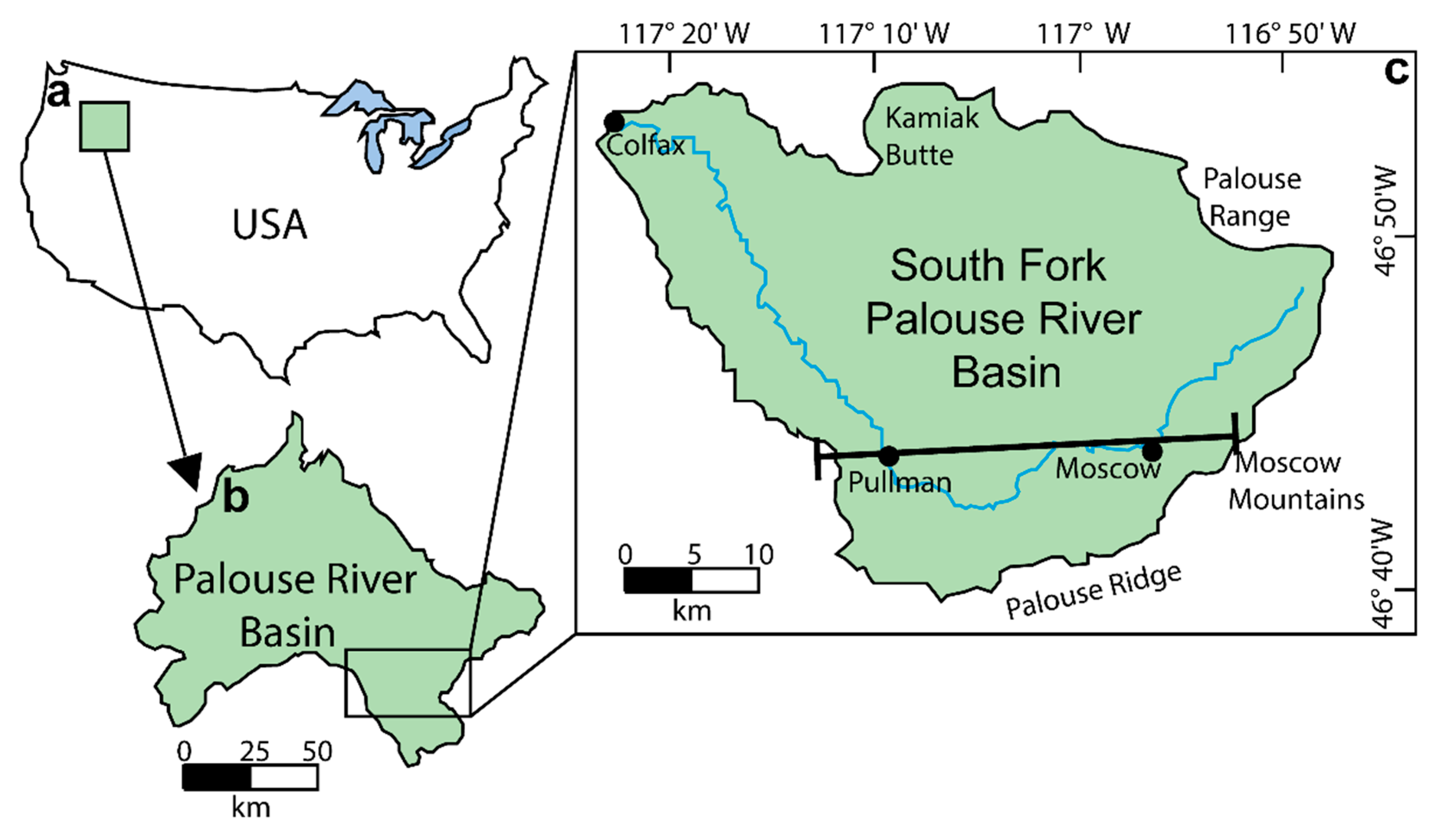
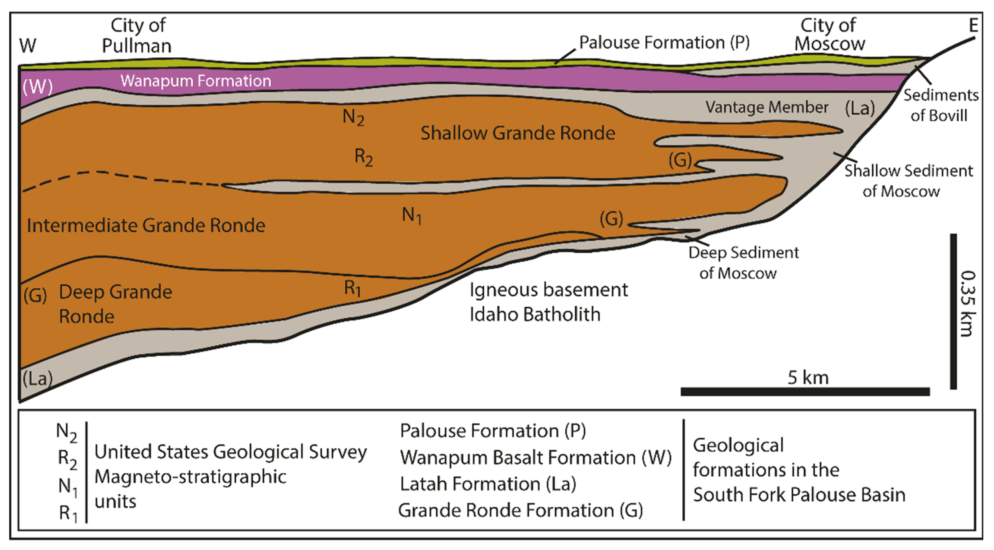
2.1. Geology
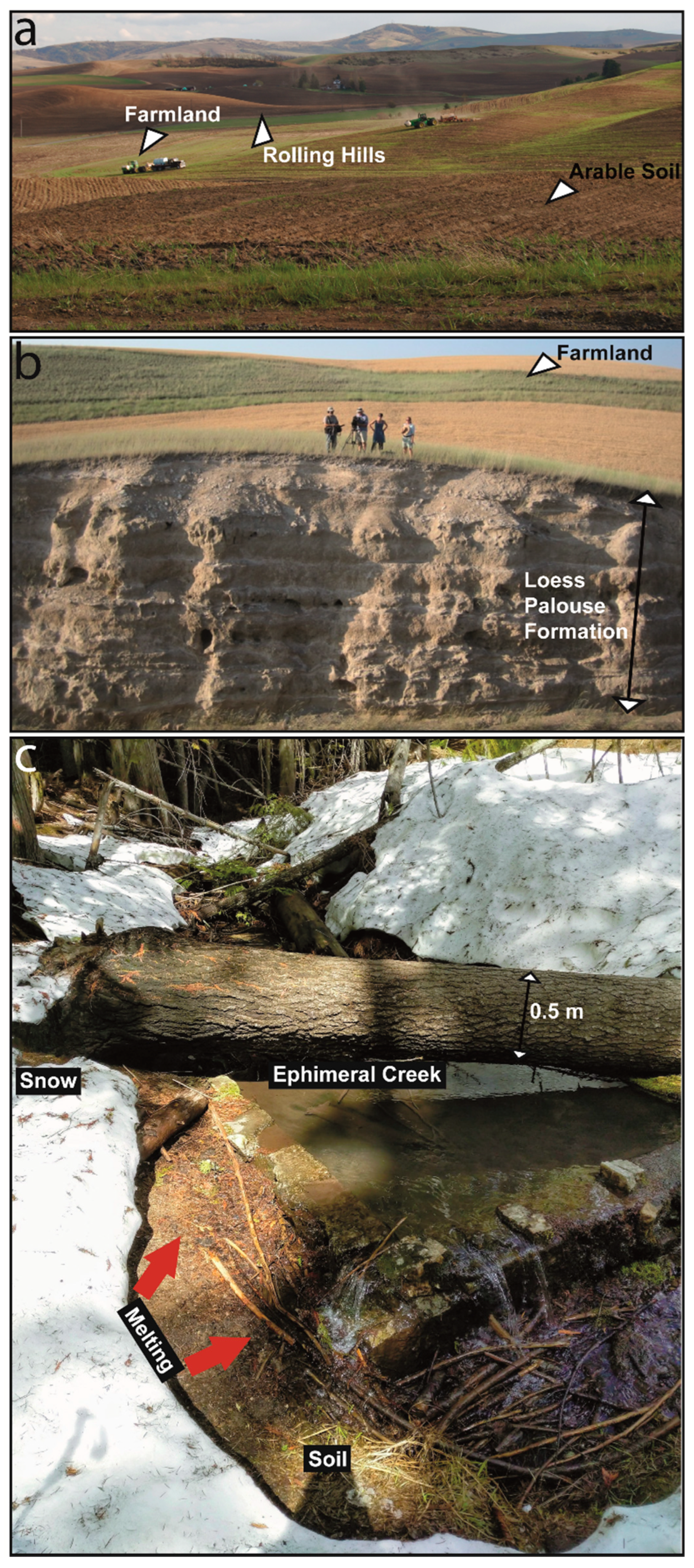
2.2. Surface Hydrology and Hydrogeologic Units
3. Aquifer Recharge
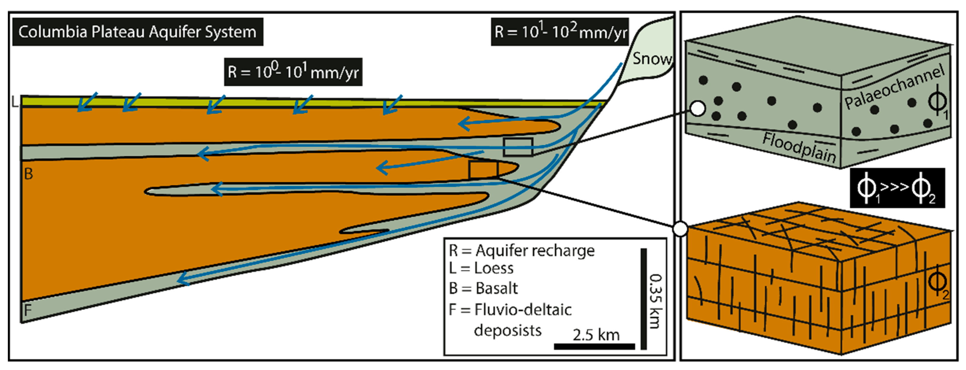
3.1. Pathways
3.2. Estimation
3.3. Groundwater Flow Models
3.4. Future Research
4. Conclusions
- The recent collection and interpretation of hydrologic tracers (noble gases and H, O, C, and S isotopes) across the basin and within the different formations of the alluvial and confined aquifer system revealed a snowmelt-mountain front recharge process. The snowmelt from the mountain reliefs in the eastern portion of the basin represents the principal input for groundwater recharge, which was validated through simulation of particle traces through this multiple aquifer system;
- Identification and recognition of paleochannels as coarser grained, highly permeable flowpaths originating along the mountain front shifted the perception from past ideas of very limited recharge or diffuse vertical recharge to the confined aquifer system. These architectural elements of fluvial origin represent the principal pathways for the snowmelt-mountain front recharge to the fractured basalt and interbedded sediment aquifer;
- The most recent MODFLOW model is based on a multidimensional physio-chemical dataset acquired that assisted in prescribing appropriate recharge parameters. Modelled effective recharge of 25 and 105 mm/year appear to be appropriate for the basin plain and the mountain front, respectively. These values fit previous efforts on quantifying aquifer recharge based on chloride, storage, and mass-balance methods. This scenario contrasts a prior MODFLOW model that overestimated the recharge and underestimated hydraulic conductivity because of the perception of diffuse vertical recharge;
- Research on surface-groundwater interaction and aquifer recharge can be further advanced by using new EPM solutions that incorporate overland flow, unsaturated and groundwater flow given the pre-existence of a robust dataset at the study site.
Author Contributions
Funding
Institutional Review Board Statement
Informed Consent Statement
Data Availability Statement
Acknowledgments
Conflicts of Interest
References
- Amoruso, A.; Crescentini, L.; Petitta, M.; Tallini, M. Parsimonious recharge/discharge modeling in carbonate fractured aquifers: The groundwater flow in the Gran Sasso aquifer (Central Italy). J. Hydrol. 2013, 476, 136–146. [Google Scholar] [CrossRef]
- Dillon, P. 2005. Future management of aquifer recharge. Hydrogeol. J. 2005, 13, 313–316. [Google Scholar] [CrossRef]
- Medici, G.; West, L.J.; Banwart, S.A. Groundwater flow velocities in a fractured carbonate aquifer-type: Implications for contaminant transport. J. Contam. Hydrol. 2019, 222, 1–16. [Google Scholar] [CrossRef] [PubMed]
- Medici, G.; Baják, P.; West, L.J.; Chapman, P.J.; Banwart, S.A. DOC and nitrate fluxes from farmland; impact on a dolostone aquifer KCZ. J. Hydrol. 2021, 595, 125658. [Google Scholar] [CrossRef]
- Maliva, R.G. Managed aquifer recharge: State-of-the-art and opportunities. Water Sci. Technol. Water Supply 2015, 15, 578–588. [Google Scholar] [CrossRef]
- Freeze, A.R.; Cherry, J.A. Groundwater; Prentice-Hall: Hoboken, NJ, USA, 1979. [Google Scholar]
- Hiscock, K.M.; Bense, F.M. Hydrogeology: Principles and Practice; Wiley-Blackwell: New York, NY, USA, 2014. [Google Scholar]
- Holden, J. Water Resources: An Integrated Approach; Taylor & Francis Ltd.: Abingdon-on-Thames, UK, 2020. [Google Scholar]
- Hill, M.C.; Tiedeman, C.R. Effective Groundwater Model Calibration; Wiley: New York, NY, USA, 2007. [Google Scholar]
- Pathak, R.; Awasthi, M.K.; Sharma, S.K.; Hardaha, M.K.; Nema, R.K. Ground water flow modelling using MODFLOW-A review. Int. J. Curr. Microbiol. Appl. Sci. 2018, 7, 83–88. [Google Scholar] [CrossRef]
- Hitchmough, A.M.; Riley, M.S.; Herbert, A.W.; Tellam, J.H. Estimating the hydraulic properties of the fracture network in a sandstone aquifer. J. Contam. Hydrol. 2018, 93, 38–57. [Google Scholar] [CrossRef]
- Noushabadi, M.J.; Jourde, H.; Massonnat, G. Influence of the observation scale on permeability estimation at local and regional scales through well tests in a fractured and karstic aquifer (Lez aquifer, Southern France). J. Hydrol. 2011, 403, 321–336. [Google Scholar] [CrossRef]
- Medici, G.; West, L.J. Groundwater flow velocities in karst aquifers; importance of spatial observation scale and hydraulic testing for contaminant transport prediction. Environ. Sci. Pollut. Res. 2021, 28, 43050–43063. [Google Scholar] [CrossRef]
- Medici, G.; West, L.J. Review of groundwater flow and contaminant transport modelling approaches for the Sherwood Sandstone aquifer, UK; insights from analogous successions worldwide. Q. J. Eng. Geol. Hydrogeol. 2022, 55. [Google Scholar] [CrossRef]
- Sanchez-Vila, X.; Fernàndez-Garcia, D. Debates-Stochastic subsurface hydrology from theory to practice: Why stochastic modeling has not yet permeated into practitioners? Water Resour. Res. 2016, 52, 9246–9258. [Google Scholar] [CrossRef]
- Schulze-Makuch, D.; Carlson, D.A.; Cherkauer, D.S.; Malik, P. Scale dependency of hydraulic conductivity in heterogeneous media. Groundwater 1999, 37, 904–919. [Google Scholar] [CrossRef]
- Manna, F.; Cherry, J.A.; McWhorter, D.B.; Parker, B.L. Groundwater recharge assessment in an upland sandstone aquifer of southern California. J. Hydrol. 2016, 541, 787–799. [Google Scholar] [CrossRef]
- Manna, F.; Walton, K.M.; Cherry, J.A.; Parker, B.L. Mechanisms of recharge in a fractured porous rock aquifer in a semi-arid region. J. Hydrol. 2017, 555, 869880. [Google Scholar] [CrossRef]
- Mattei, A.; Barbecot, F.; Goblet, P.; Guillon, S. Pore water isotope fingerprints to understand the spatiotemporal groundwater recharge variability in ungauged watersheds. Vadose Zone J. 2020, 19, 20066. [Google Scholar] [CrossRef]
- Alam, S.; Borthakur, A.; Ravi, S.; Gebremichael, M.; Mohanty, S.K. Managed aquifer recharge implementation criteria to achieve water sustainability. Sci. Total Environ. 2021, 768, 144992. [Google Scholar] [CrossRef] [PubMed]
- Casanova, J.; Devau, N.; Pettenati, M. Managed Aquifer Recharge: An Overview of Issues and Options; Integrated Groundwater Management; Springer: Berlin, Germany, 2016. [Google Scholar]
- DeNicola, E.; Aburizaiza, O.S.; Siddique, A.; Khwaja, H.; Carpenter, D.O. Climate change and water scarcity: The case of Saudi Arabia. Ann. Glob. Health 2015, 81, 342–353. [Google Scholar] [CrossRef]
- Lézine, A.M.; Hély, C.; Grenier, C.; Braconnot, P.; Krinner, G. Sahara and Sahel vulnerability to climate changes, lessons from Holocene hydrological data. Quat. Sci. Rev. 2011, 30, 3001–3012. [Google Scholar] [CrossRef]
- Maeng, S.K.; Sharma, S.K.; Lekkerkerker-Teunissen, K.; Amy, G.L. 2011. Occurrence and fate of bulk organic matter and pharmaceutically active compounds in managed aquifer recharge: A review. Water Res. 2011, 45, 3015–3033. [Google Scholar] [CrossRef]
- Meixner, T.; Manning, A.H.; Stonestrom, D.A.; Allen, D.M.; Ajami, H.; Blasch, K.W.; Brookfield, A.E.; Castro, C.L.; Clark, J.F.; Gochis, D.J.; et al. Implications of projected climate change for groundwater recharge in the western United States. J. Hydrol. 2016, 534, 124–138. [Google Scholar] [CrossRef] [Green Version]
- Manna, F.; Murray, S.; Abbey, D.; Martin, P.; Cherry, J.; Parker, B. Spatial and temporal variability of groundwater recharge in a sandstone aquifer in a semiarid region. Hydrol. Earth Syst. Sci. 2019, 23, 2187–2205. [Google Scholar] [CrossRef]
- Bush, J.H.; Dunlap, P.; Reidel, S.P. Miocene Evolution of the Moscow-Pullman Area, Idaho and Washington. Idaho Geological Survey Technical Report 18–3, pp. 42. 2018. Available online: https://www.idahogeology.org/product/t-18-3 (accessed on 31 August 2022).
- Bush, J.H.; Dunlap, P.; Reidel, S.P. Geologic Cross Sections Across the Moscow-Pullman Basin, Idaho and Washington. Idaho Geological Survey Technical Report 181, 3 Sheets, Scale 1:24,000. 2018. Available online: https://www.idahogeology.org/product/t-18-1 (accessed on 31 August 2022).
- Beall, A.; Fiedler, F.; Boll, J.; Cosens, B. Sustainable water resource management and participatory system dynamics. Case study: Developing the Palouse basin participatory model. Sustainability 2011, 3, 720–742. [Google Scholar] [CrossRef]
- Ortega-Pieck, A.; Norby, J.; Brooks, E.S.; Strawn, D.; Crump, A.R.; Huggins, D.R. Sources and subsurface transport of dissolved reactive phosphorus in a semiarid, no-till catchment with complex topography. J. Environ. Qual. 2020, 49, 1286–1297. [Google Scholar] [CrossRef] [PubMed]
- Candel, J.; Brooks, E.; Sánchez-Murillo, R.; Grader, G.; Dijksma, R. Identifying groundwater recharge connections in the Moscow (USA) sub-basin using isotopic tracers and a soil moisture routing model. Hydrogeol. J. 2016, 24, 1739–1751. [Google Scholar] [CrossRef]
- Carlson, C.; Canty, D.; Steiner, F.; Mack, N. A path for the Palouse: An example of conservation and recreation planning. Landsc. Urban Plan. 1989, 17, 1–19. [Google Scholar] [CrossRef]
- Frazier, B.E.; Cheng, Y. Remote sensing of soils in the eastern Palouse region with Landsat Thematic Mapper. Remote Sens. Environ. 1989, 28, 317–325. [Google Scholar] [CrossRef]
- Sánchez-Murillo, R.; Brooks, E.S.; Elliot, W.J.; Boll, J. Isotope hydrology and baseflow geochemistry in natural and human-altered watersheds in the Inland Pacific Northwest, USA. Isot. Environ. Health Stud. 2015, 51, 231–254. [Google Scholar] [CrossRef]
- Dijksma, R.; Brooks, E.S.; Boll, J. Groundwater recharge in Pleistocene sediments overlying basalt aquifers in the Palouse Basin, USA: Modeling of distributed recharge potential and identification of water pathways. Hydrogeol. J. 2011, 19, 489–500. [Google Scholar] [CrossRef]
- O’Geen, A.T.; McDaniel, P.A.; Boll, J. Chloride distributions as indicators of vadose zone stratigraphy in Palouse loess deposits. Vadose Zone J. 2002, 1, 150–157. [Google Scholar] [CrossRef]
- O’Geen, A.T.; McDaniel, P.A.; Boll, J.; Brooks, E. Hydrologic processes in valley soilscapes of the eastern Palouse basin in northern Idaho. Soil Sci. 2003, 168, 846–855. [Google Scholar] [CrossRef]
- O’Geen, A.T.; McDaniel, P.A.; Boll, J.; Keller, C.K. Paleosols as deep regolith: Implications for ground-water recharge across a loessial climosequence. Geoderma 2005, 126, 85–99. [Google Scholar] [CrossRef]
- Bush, J.H.; Garwood, D.L.; Dunlap, P.; Lewis, R.S.; Schmidt, K.L. Geology and geologic history of the Moscow-Pullman basin, Idaho and Washington, from late Grande Ronde to late Saddle Mountains time. In Exploring the Geology of the Inland Northwest; Lewis, R.S., Schmidt, K.L., Eds.; Geological Society of America: Boulder, CO, USA, 2016. [Google Scholar]
- Hooper, P.R. Petrology and chemistry of the Rock Creek flow, Columbia River basalt, Idaho. Geol. Soc. Am. Bull. 1974, 85, 15–26. [Google Scholar] [CrossRef]
- Mangan, M.T.; Wright, T.L.; Swanson, D.A.; Byerly, G.R. Regional correlation of Grande ronde basalt flows, Columbia river basalt group, Washington, Oregon, and Idaho. Geol. Soc. Am. Bull. 1986, 97, 1300–1318. [Google Scholar] [CrossRef]
- Reidel, S.P.; Camp, V.E.; Tolan, T.L.; Martin, B.S. The Columbia River flood basalt province: Stratigraphy, areal extent, volume, and physical volcanology. Geol. Soc. Am. Spec. Pap. 2013, 497, 1–43. [Google Scholar]
- Teasdale, E.W.; Bush, J.H.; Garwood, D.L. Structural Partitioning of Ground Water Resources in Moscow, Idaho and Pullman, Washington. In Proceedings of the AGU Fall Meeting 2011 (American Geophysical), San Francisco, CA, USA, 10–14 December 2001. [Google Scholar]
- Behrens, D.; Langman, J.B.; Brooks, E.S.; Boll, J.; Waynant, K.; Moberly, J.G.; Dodd, J.K.; Dodd, J.W. Tracing δ18O and δ2H in Source Waters and Recharge Pathways of a Fractured-Basalt and Interbedded-Sediment Aquifer, Columbia River Flood Basalt Province. Geosciences 2021, 11, 400. [Google Scholar] [CrossRef]
- Moravec, B.G.; Keller, C.K.; Smith, J.L.; Allen-King, R.M.; Goodwin, A.J.; Fairley, J.P.; Larson, P.B. Oxygen-18 dynamics in precipitation and streamflow in a semi-arid agricultural watershed, Eastern Washington, USA. Hydrol. Processes Int. J. 2010, 24, 446–460. [Google Scholar] [CrossRef]
- Langman, J.B.; Martin, J.; Gaddy, E.; Boll, J.; Behrens, D. Snowpack Aging, Water Isotope Evolution, and Runoff Isotope Signals, Palouse Range, Idaho, USA. Hydrology 2022, 9, 94. [Google Scholar] [CrossRef]
- Carlson, J.E.; Schnabel, B.; Beus, C.E.; Dillman, D.A. Changes in the soil conservation attitudes and behaviors of farmers in the Palouse and Camas prairies: 1976–1990. J. Soil Water Conserv. 1994, 49, 493–500. [Google Scholar]
- Brooks, E.S.; Boll, J.; McDaniel, P.A. Distributed and integrated response of a geographic information system-based hydrologic model in the eastern Palouse region, Idaho. Hydrol. Processes Int. J. 2007, 21, 110–122. [Google Scholar] [CrossRef]
- Larson, K.R.; Keller, C.K.; Larson, P.B.; Allen-King, R.M. Water resource implications of 18O and 2H distributions in a basalt aquifer system. Groundwater 2000, 38, 947–953. [Google Scholar] [CrossRef]
- Keller, C.K.; Butcher, C.N.; Smith, J.L.; Allen-King, R.M. Nitrate in tile drainage of the semiarid Palouse basin. J. Environmen. Qual. 2008, 37, 353–361. [Google Scholar] [CrossRef] [PubMed]
- Duckett, K.A.; Langman, J.B.; Bush, J.H.; Brooks, E.S.; Dunlap, P.; Welker, J.M. Isotopic discrimination of aquifer recharge sources, subsystem connectivity and flow patterns in the South Fork Palouse River Basin, Idaho and Washington, USA. Hydrology 2019, 6, 15. [Google Scholar] [CrossRef] [Green Version]
- Badon, M.M. Implementation of Groundwater Monitoring Program and Aquifer Testing in the Wanapum Aquifer System, Latah County, Idaho. Master’s Thesis, University of Idaho, Moscow, ID, USA, 2007. [Google Scholar]
- Pritchard, C.J.; Gaylord, D.R.; Adams, D.B.; Ernst, S.; Hermanson, M. Role of Quaternary glacial-outburst megaflood paleochannel deposits in a basalt-dominated aquifer system in the West Plains area of eastern Washington, USA. Hydrogeol. J. 2020, 28, 921–939. [Google Scholar] [CrossRef]
- Moran, K. Interpretation of Long-Term Grande Ronde Aquifer Testing in the Palouse Basin of Idaho and Washington. Ph.D. Thesis, University of Idaho, Moscow, ID, USA, 2007. [Google Scholar]
- Ely, D.M.; Bachmann, M.P.; Vaccaro, J.J. Numerical Simulation of Groundwater Flow for the Yakima River Basin Aquifer System, Washington; Report 2011-5155; United States Geological Survey: Seattle, DC, USA, 2011. [Google Scholar]
- Ely, D.M.; Burns, E.R.; Morgan, D.S.; Vaccaro, J.J. Numerical Simulation of Groundwater Flow in the Columbia Plateau Regional Aquifer System, Idaho, Oregon, and Washington; Report 2014-5127; United States Geological Survey: Seattle, DC, USA, 2014. [Google Scholar]
- Burns, E.R.; Williams, C.F.; Ingebritsen, S.E.; Voss, C.I.; Spane, F.A.; DeAngelo, J. Understanding heat and groundwater flow through continental food basalt provinces: Insights gained from alternative models of permeability/depth relationships for the Columbia Plateau, USA. Geofluids 2015, 15, 120–138. [Google Scholar] [CrossRef]
- Chatters, R.M. Washington State University natural radiocarbon measurements I. Radiocarbon 1968, 10, 479–498. [Google Scholar] [CrossRef]
- Douglas, A.A.; Osiensky, J.L.; Keller, C.K. Carbon-14 dating of ground water in the Palouse Basin of the Columbia River basalts. J. Hydrol. 2007, 334, 502–512. [Google Scholar] [CrossRef]
- Lum, W.E.; Smoot, J.L.; Smoot, J.L.; Ralston, D.R. Geohydrology and Numerical Model Analysis of Ground-Water Flow in the Pulman–Moscow Area, Washington and Idaho; Report 4104; Department of the Interior, United States Geological Survey: Seattle, DC, USA, 1990. [Google Scholar]
- Barker, R.A. Computer Simulation and Geohydrology of a Basalt Aquifer System in the Pullman–Moscow Basin, Washington and Idaho; Water Supply Bulletin 48; Washington Department of Ecology Water-Supply Bulletin: Lacey, Washington, USA, 1979. [Google Scholar]
- Bauer, H.H.; Vaccaro, J.J. Regional Aquifer-System Analysis Program. Water Resour. Investig. Rep. 1990, 88, 4108. [Google Scholar]
- Vaccaro, J.J. Sensitivity of groundwater recharge estimates to climate variability and change, Columbia Plateau, Washington. J. Geophys. Res. Atmos. 1992, 97, 2821–2833. [Google Scholar] [CrossRef]
- Jones, R.W.; Ross, S.H. Moscow Basin Ground Water Studies; Idaho Bureau of Mines and Geology: Boise, ID, USA, 1972. [Google Scholar]
- Lin, C.L. Factors Affecting Ground Water Recharge in the Moscow Basin, Latah County Idaho. Master’s Thesis, Department of Geology, Washington State University, Pullman, DC, USA, 1967. [Google Scholar]
- Pierce, J.L. Geology and Hydrology of the Moscow East and Robinson Lake Quadrangles, Latah County, Idaho. Master’s Thesis, University of Idaho, Moscow, ID, USA, 1998. [Google Scholar]
- Duckett, K.A.; Langman, J.B.; Bush, J.H.; Brooks, E.S.; Dunlap, P.; Stanley, J.R. Noble gases, dead carbon, and reinte pretation of groundwater ages and travel time in local aquifers of the Columbia River Basalt Group. J. Hydrol. 2020, 581, 124400. [Google Scholar] [CrossRef]
- Foxworthy, B.L.; Washburn, R.L. Ground Water in the Pullman Area, Whitman County, Washington. Water Supply Paper. 2016. Available online: http://pubs.usgs.gov/wsp/1655/report.pdf (accessed on 31 August 2022).
- Stevens, P.R. Ground-Water Problems in the Vicinity of Moscow, Latah County, Idaho: Idaho Waters Digital Library. 2016. Available online: http://digital.lib.uidaho.edu/cdm/ref/collection/idahowater/id/286 (accessed on 31 August 2022).
- O’Brien, R.; Keller, C.K.; Smith, J.L. Multiple tracers of shallow ground-water flow and recharge in hilly loess. Groundwater 1996, 34, 675–682. [Google Scholar] [CrossRef]
- Reeves, M. Estimating Recharge Uncertainty Using Bayesian Model. Averaging and Expert Elicitation with Social Implications; University of Idaho: Moscow, ID, USA, 2009. [Google Scholar]
- Johnson, G.E. Estimating Groundwater Recharge Beneath Different Slope Positions in the Palouse formation Using a Numerical Unsaturated Flow Model. Master’s Thesis, Washington State University, Pullman, WA, USA, 1991. [Google Scholar]
- Muniz, H.R. Computer Modeling of Vadose. Zone Groundwater Flux at a Hazardous Waste Site; Washington State University: Pullman, WA, USA, 1991. [Google Scholar]
- Baines, C.A. Determination of Sustained Yield for the Shallow Basalt Aquifer in the Moscow Area, Idaho; Idaho Water Resources Research Institute: Moscow, ID, USA, 1992. [Google Scholar]
- Jones, R.W.; Ross, S.H. Detailed Ground Water Investigation of Moscow Basin: Research Technical Completion Report; Project A-011-IDA; Idaho Water Resources Research Institute: Moscow, ID, USA, 1969. [Google Scholar]
- Theis, C.V. The relation between the lowering of the piezometric surface and the rate and duration of discharge of a well using ground-water storage. Eos Trans. Am. Geophys. Union 1935, 16, 519–524. [Google Scholar] [CrossRef]
- Crosby, J.W.; Chatters, R.M. Water Dating Techniques as Applied to the Pullman-Moscow Ground-Water Basin; Buletin 296; Washington State University College of Engineering Research Division: Pullman, WA, USA, 1965. [Google Scholar]
- Smoot, J.L.; Ralston, D.R. Hydrology and a Mathematical Model of Ground-Water Flow in the Pullman-Moscow Region, Washington and Idaho; Idaho Water Resources Research Institute, University of Idaho: Moscow, ID, USA, 1987; p. 118. Available online: https://www.lib.uidaho.edu/digital/iwdl/docs/iwdl-198713.html (accessed on 31 August 2022).
- Johnson, G.S.; Bloomsburg, G.; Ralston, D.R. Evaluation and Modification of the Pullman-Moscow Ground-Water Flow Model; Idaho Water Resources Research Institute, University of Idaho: Moscow, ID, USA, 1996; p. 41. Available online: https://www.lib.uidaho.edu/digital/iwdl/docs/iwdl-199605.html (accessed on 31 August 2022).
- Burt, O.R. Farm level economics of soil conservation in the Palouse area of the Northwest. Am. J. Agric. Econ. 1981, 63, 83–92. [Google Scholar] [CrossRef]
- Fairley, J.P.; Solomon, M.D.; Hinds, J.J.; Grader, G.W.; Bush, J.H.; Rand, A.L. Latah County Hydrologic Characterization Project; Final Report; Idaho Department of Water Resources: Boise, ID, USA, 2006. [Google Scholar]
- Medici, G.; Engdahl, N.B.; Langman, J.B. A basin-scale groundwater flow model of the Columbia Plateau regional aquifer system in the Palouse (USA): Insights for aquifer vulnerability assessment. Int. J. Environ. Res. 2021, 15, 299–312. [Google Scholar] [CrossRef]
- Ren, S.; Gragg, S.; Zhang, Y.; Carr, B.J.; Yao, G. Borehole characterization of hydraulic properties and groundwater flow in a crystalline fractured aquifer of a headwater mountain watershed, Laramie Range, Wyoming. J. Hydrol. 2018, 561, 780–795. [Google Scholar] [CrossRef]
- DOE. Environmental Assessment: Reference Repository Location, Hanford Site, Washington; Report 1; United States Department of Energy: Seattle, DC, USA, 1986. [Google Scholar]
- Im, S.; Kim, H.; Kim, C.; Jang, C. Assessing the impacts of land use changes on watershed hydrology using MIKE SHE. Environ. Geol. 2009, 57, 231–239. [Google Scholar] [CrossRef]
- Brooks, E.S.; Boll, J.; McDaniel, P.A. Hydropedology in seasonally dry landscapes: The Palouse region of the Pacific Northwest, USA. In Hydropedology; Henry Lib: Seattle, WA, USA, 2012; pp. 329–350. [Google Scholar]


| Lithostratigraphy | Geological Time | Thickness (m) | Lithotype |
|---|---|---|---|
| Palouse Formation, P | Holocene-Pleistocene | 1–10 | Clay, Silt |
| Sediments of Bovill Member, LF | Miocene | 0–20 | Clay, Silt, Sand |
| Wanapum Basalt Formation, CRGB Vantage Member, LF Upper Grande Ronde Formation, CRGB Shallow Sediments of Moscow Member, LF | Miocene | 40–70 | Fractured Basalt |
| Miocene | 2–10 | Clay, silt, sand | |
| Miocene | 50–80 | Fractured Basalt | |
| Miocene | 0–15 | Clay, silt, sand | |
| Intermediate Grande Ronde Formation, CRGB | Miocene | 160–220 | Fractured Basalt |
| Lower Grande Ronde Formation, CRGB | Miocene | 20–80 | Fractured Basalt |
| Deep Sediments of Moscow Member, LF | Miocene | 0–25 | Clay, silt, sand |
| Type of Recharge | Method | Recharge Rates (mm/Year) | Reference |
|---|---|---|---|
| Potential | Soil Moisture Model | 0–317 | [35] |
| Effective | LEACHIM | 105 | [72] |
| LEACHIM | 25–103 | [73] | |
| Mass Balance | 16 | [68] | |
| Mass Balance | 30 | [69] | |
| Zero Flux Plane | 45 | [74] | |
| Chloride | 3–40 | [70] | |
| Chloride | 3–10 | [38] | |
| 3D MODFLOW Model | 250 | [60] | |
| 3D MODFLOW Model | 25–103 | [61] | |
| 3D Fortran Model | 17 | [61] | |
| Storage Equation | 122 | [71] |
Publisher’s Note: MDPI stays neutral with regard to jurisdictional claims in published maps and institutional affiliations. |
© 2022 by the authors. Licensee MDPI, Basel, Switzerland. This article is an open access article distributed under the terms and conditions of the Creative Commons Attribution (CC BY) license (https://creativecommons.org/licenses/by/4.0/).
Share and Cite
Medici, G.; Langman, J.B. Pathways and Estimate of Aquifer Recharge in a Flood Basalt Terrain; A Review from the South Fork Palouse River Basin (Columbia River Plateau, USA). Sustainability 2022, 14, 11349. https://doi.org/10.3390/su141811349
Medici G, Langman JB. Pathways and Estimate of Aquifer Recharge in a Flood Basalt Terrain; A Review from the South Fork Palouse River Basin (Columbia River Plateau, USA). Sustainability. 2022; 14(18):11349. https://doi.org/10.3390/su141811349
Chicago/Turabian StyleMedici, Giacomo, and Jeff B. Langman. 2022. "Pathways and Estimate of Aquifer Recharge in a Flood Basalt Terrain; A Review from the South Fork Palouse River Basin (Columbia River Plateau, USA)" Sustainability 14, no. 18: 11349. https://doi.org/10.3390/su141811349