
One Billion Years of Earth History: Challenges of Valorizing the Outstanding Geodiversity of Southwest Germany for Sustainable Geotourism

Abstract
:1. Introduction
2. Conceptual Basis
2.1. Geodiversity
2.2. Geotourism
2.3. Geoparks
2.4. Geoconservation
2.5. Geo-Education
3. Methodology
4. Case Study of Baden-Württemberg
4.1. Outstanding Geodiversity
4.1.1. World-Class Fossil Sites
4.1.2. World-Class Archaeological Sites
4.1.3. National Geotopes

| National Geotop | Nr | Geological Form | Geotouristic Valorization | Other Remarks |
|---|---|---|---|---|
| Kaiserstuhl | 1 | Miocene volcanism | Nature center and numerous nature trails, but focus mainly on the special fauna and flora | First description of plutonic rocks, e.g., Mondhaldeit or Bergalit [71] Viticulture since Roman times |
| Randecker Maar | 2 | Miocene volcanism; Maar, Part of Swabian Volcano | Nature conservation center with exhibition; Various Geopoints and tours | International importance as fossil site and for bird migration |
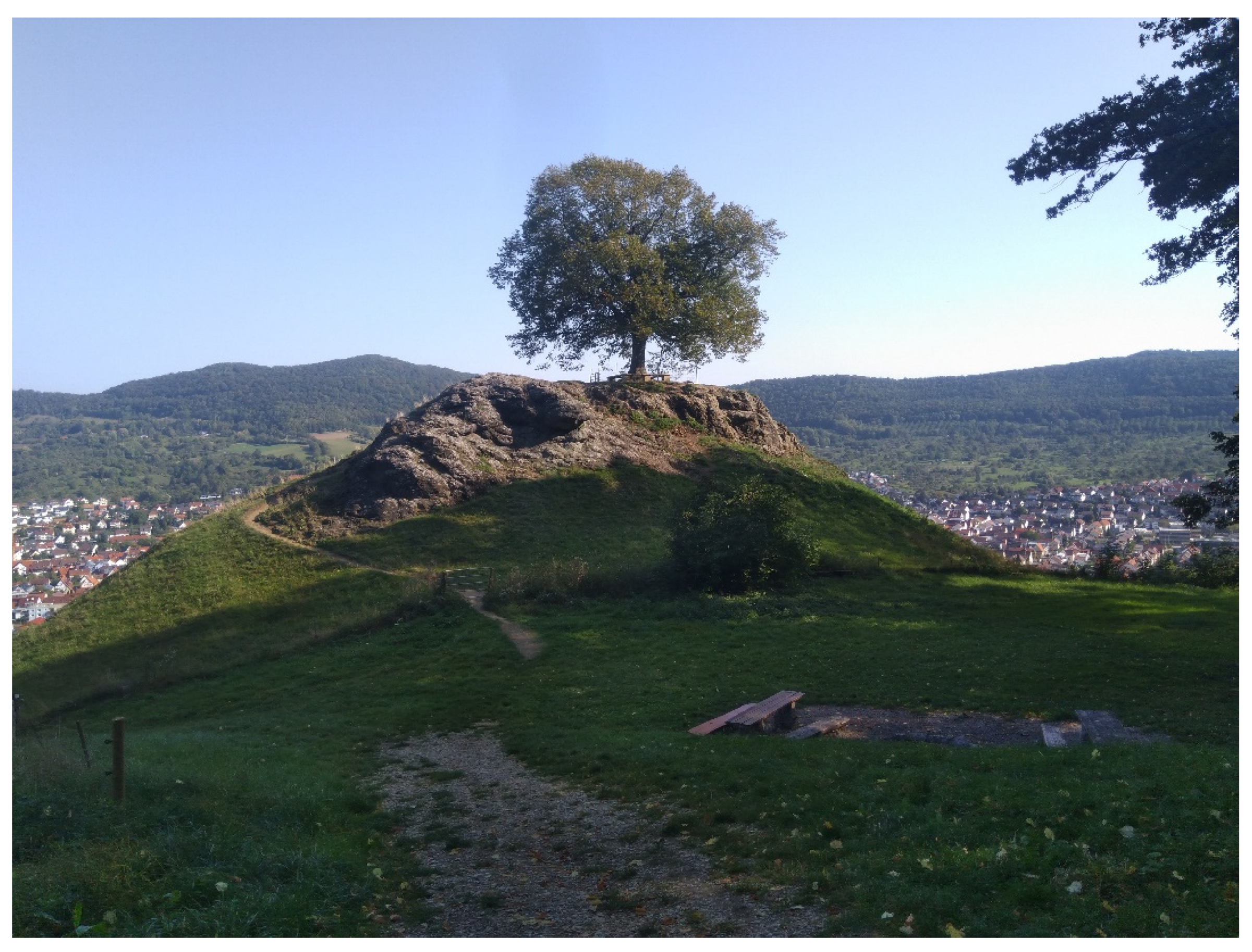
| Hegau-Vulkane | 3 | Tertiary volcanism Basalt- and Phonolith cones | Volcano trail Volcano tours | Fossil site Höwenegg of worldwide significance (Figure 3). Numerous castles on the hilltops. |
| Feldberg and Wutachschlucht (Gorge of river Wutach) | 4 | Highest mountain in Germany outside the Alps. Paleozoic gneisses; Gorge system: 60–170 m deep and 33 km long | Several sites where important fossil have been found; nature trails | Highly frequented tourism destination; Feldberg also a popular destination for winter sports |
| Holzmaden Possidonia slates | 5 | See Section 4.1.1 | Museum; fossil discovery sites | Global significance as a fossil site |
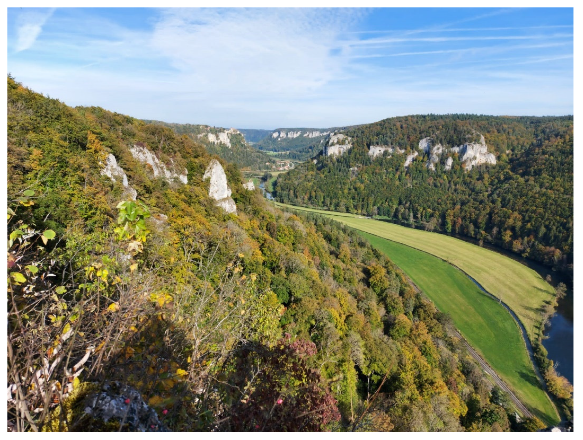
| Upper Danube Valley | 6 | Breakthrough valley with numerous Jurassic rock outcrops (Figure 4) | Numerous hiking and biking trails | Part of the international Danube Cycle Path. Stone Age caves and medieval castles |
| Blaubeurener Alb with Blautopf (carstic spring) | 7 | Second-richest spring discharge in Germany, connected with an extensive cave system | Information boards; museum of prehistory at Blaubeuren | Numerous sagas and legends about the beautiful karst spring Blautopf |
| Lonetal (Valley of river Lone) | 8 | UNESCO World Heritage site (see Section 4.1.2) One of the longest dry valleys in Germany | Archaeological theme park | Outstanding Stone Age artworks (Lion Man) |
| Isteiner Klotz | 9 | Huge Jurassic rock in the Rhine Rift Valley | 3 km long circular trail | Castle in a spectacular location. |
| Hessigheimer Felsengärten | 10 | Rock formation in above the Neckar valley | Hiking trails | Very popular climbing area |
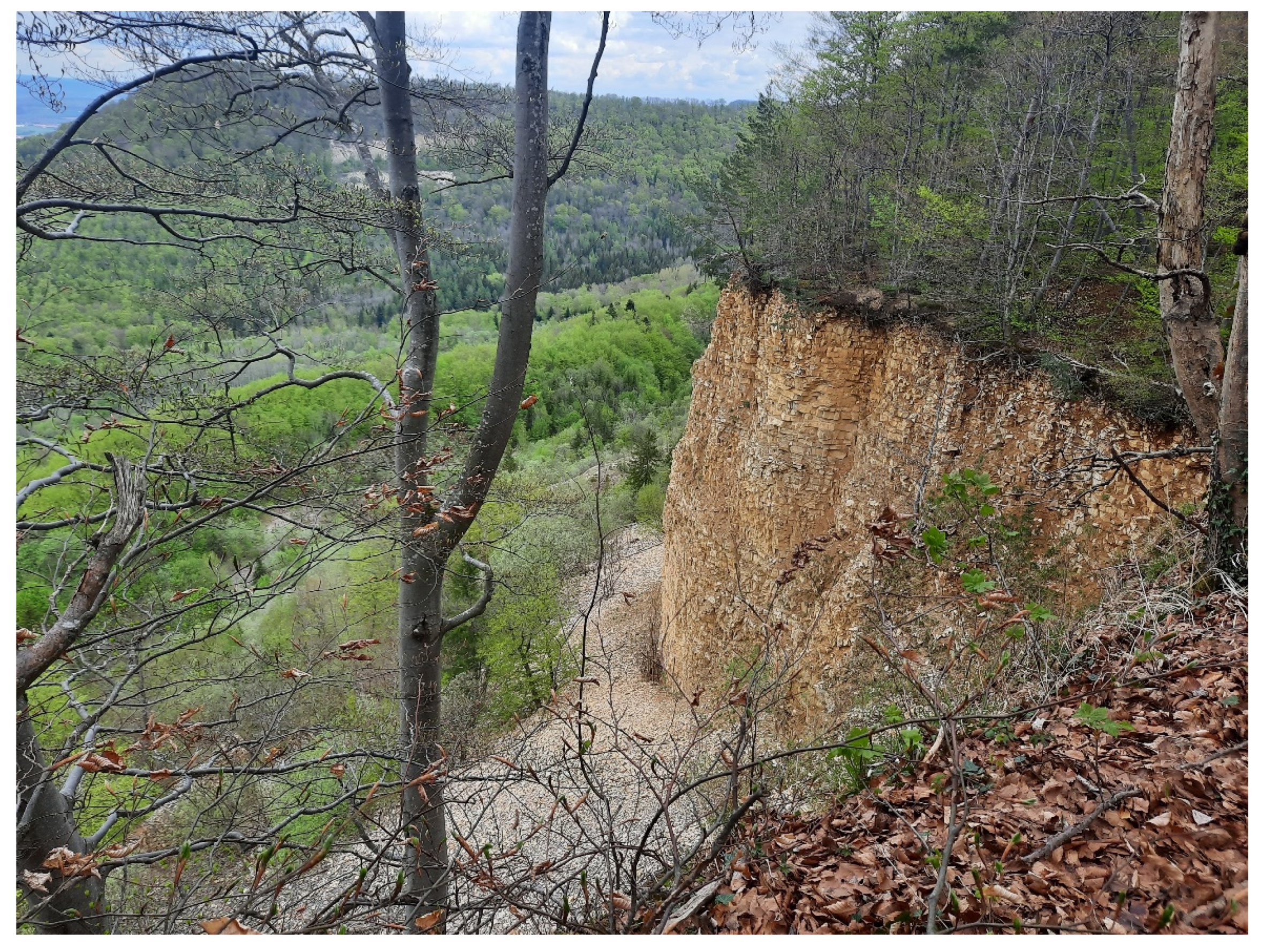
| Mössinger Bergrutsch | 11 | Extensive landslide on Jurassic cuesta (see Figure 2) | Nature trail with information panels | Outdoor Laboratory of the University of Tübingen |
| Nördlinger Ries (mostly located in Bavaria) | 12 | Meteor crater (Tertiary) | Geopark Ries with nature trails etc. | Little “sister” (small meteor crater) in the Steinheim Basin (Baden-Württemberg) |
4.1.4. National Natural Monuments
4.1.5. UNESCO Global Geoparks, National Parks and Biosphere Reserves
4.2. Important Destination for Tourism and Local Recreation
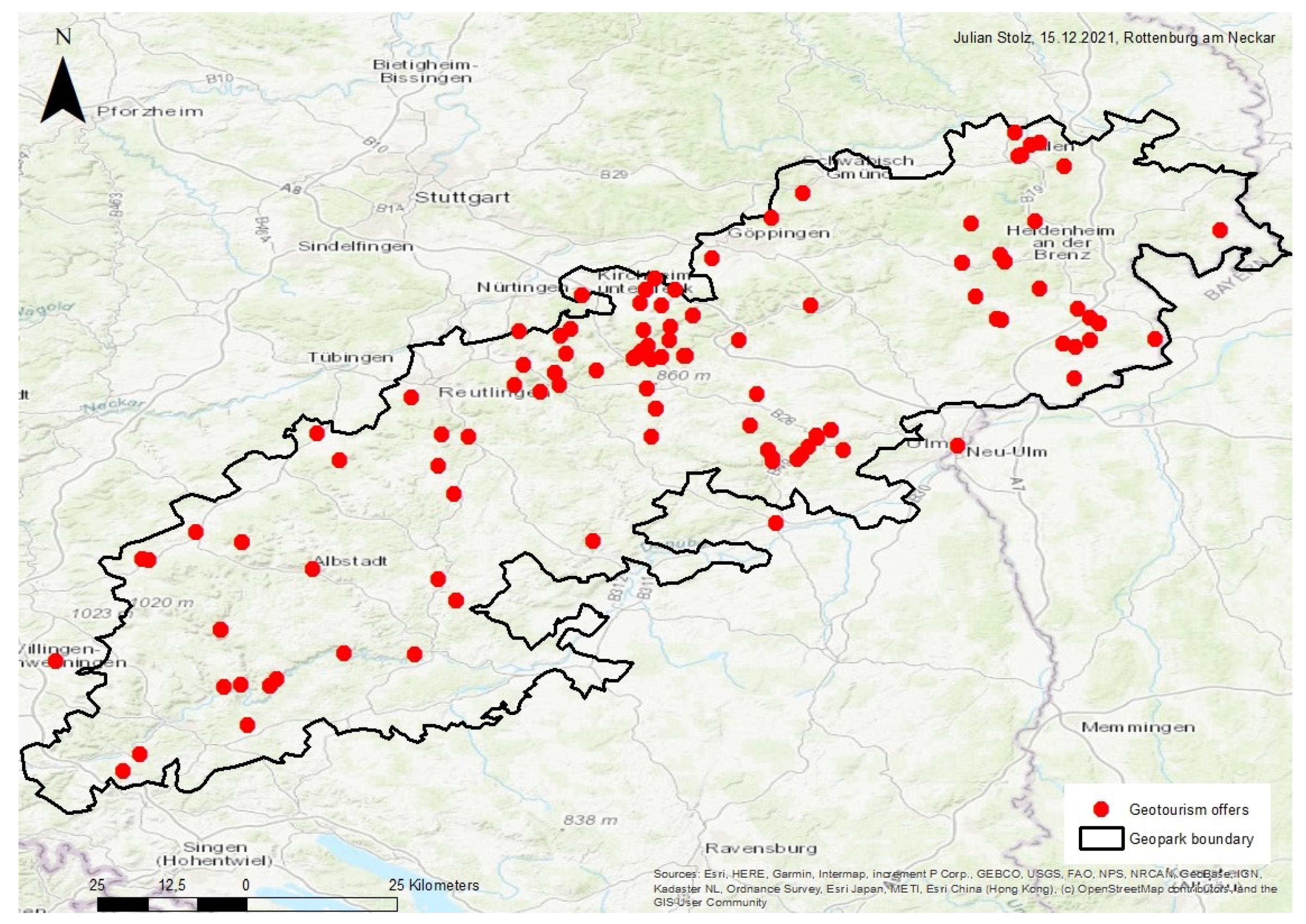
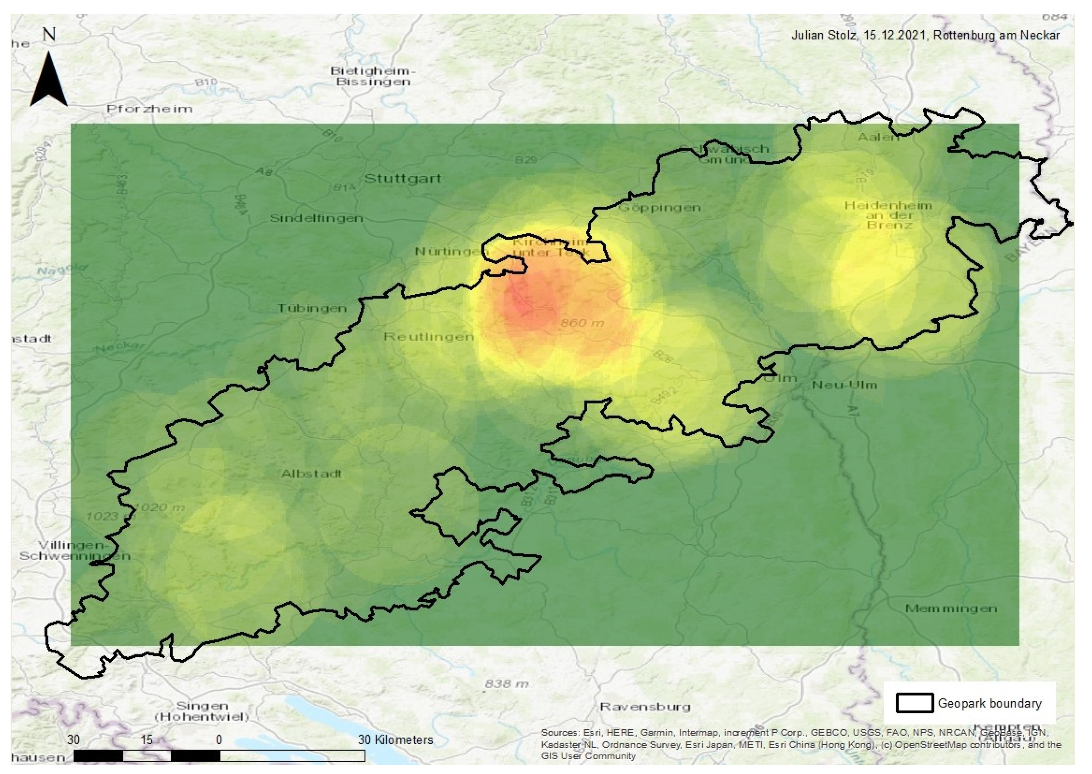
4.3. Geotourism in Baden-Württemberg
4.3.1. Historical Development of Geotourism
4.3.2. Geotourism in Baden-Württemberg Today
UNESCO Global Geopark Swabian Alb
UNESCO Global Geopark Bergstraße-Odenwald
Regions Outside Geoparks
4.3.3. Shortcomings in Geo-Education and Geoconservation
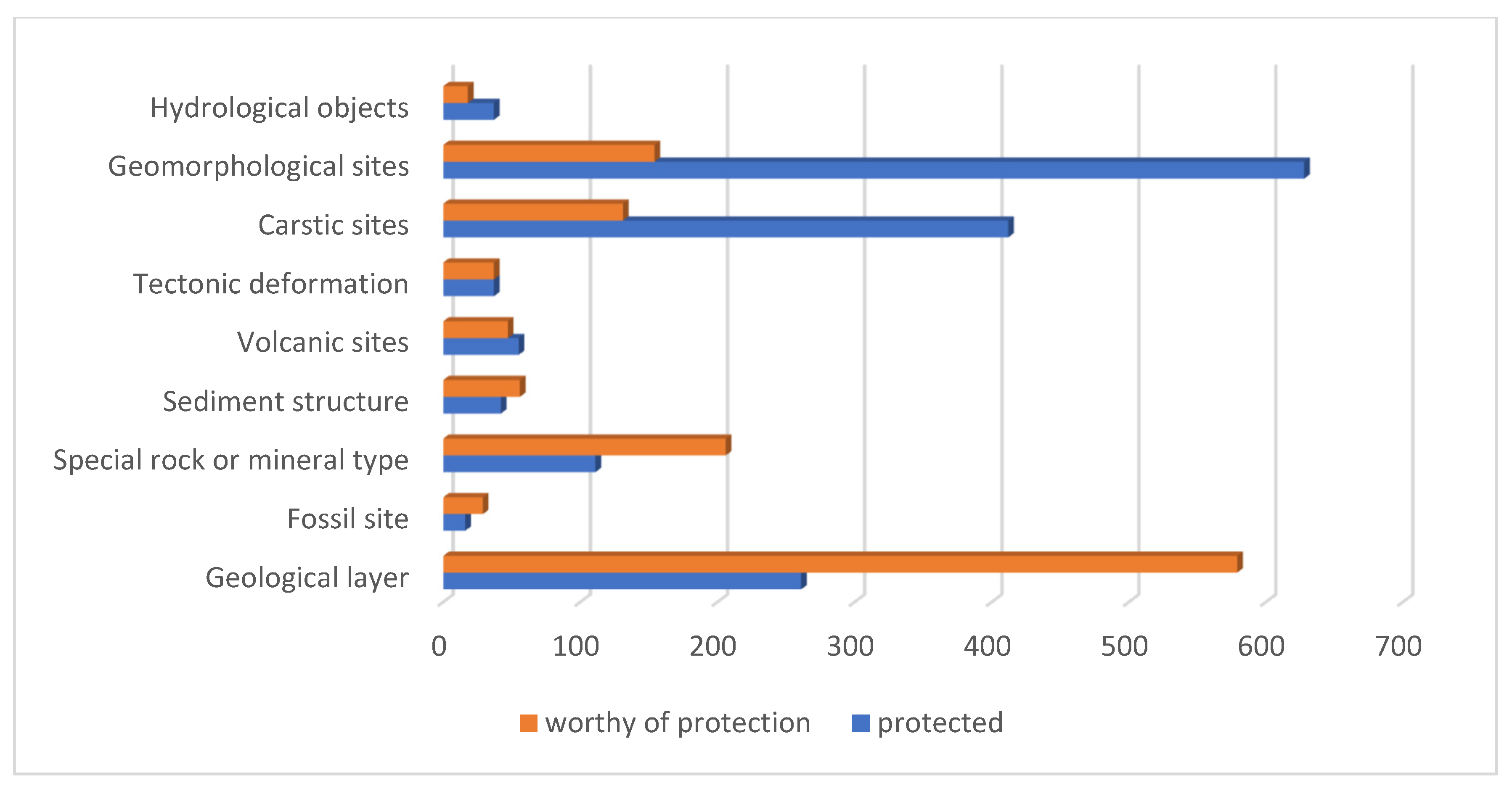
4.3.4. Geotope Protection, a Stepchild of Nature Conservation
4.4. SWOT-Analysis of Geotourism in Baden-Württemberg
4.5. Recommended Strategies for Action and Solutions
5. Discussion
6. Conclusions
- Southwest Germany has an outstanding geological and archaeological heritage.
- This heritage forms a sound basis for sustainable geotourism.
- To date, the valorization of geological and archaeological heritage is still insufficient, despite the area boasting two of the oldest German geoparks.
- Better marketing in combination with professional geo-education.
- Adequate geoconservation, especially in highly frequented areas.
- New challenges for geotourism and geoconservation, especially during the COVID-19 pandemic.
- Strategies of resilience, especially for the “World After” [44] and in the context of climate change.
- How to best define and to implement sustainable geotourism.
Funding
Institutional Review Board Statement
Informed Consent Statement
Data Availability Statement
Acknowledgments
Conflicts of Interest
References
- Hose, T. Geotourism–Appreciating the deep time of landscapes. In Niche Tourism, Contemporary Issues, Trends and Cases; Novelli, M., Ed.; Routledge: London, UK, 2004; pp. 27–37. [Google Scholar]
- Dowling, R.; Newsome, D. Handbook of Geotourism; Edward Elgar Publishing: Northampton, MA, USA, 2018; ISBN 10-1785368869. [Google Scholar]
- Dowling, R.; Newsome, D. Geotourism; Routledge: Amsterdam, The Netherlands, 2010; ISBN 978-1906884093. [Google Scholar]
- Newsome, D.; Dowling, R. Geoheritage and Geotourism. In Geoheritage: Assessment, Protection, and Management; Reynard, E., Brilha, J., Eds.; Elsevier: Amsterdam, The Netherlands, 2018; pp. 305–321. ISBN 9780128095317. [Google Scholar]
- Reynard, E.; Brilha, J. (Eds.) Geoheritage: Assessment, Protection, and Management; Elsevier: Amsterdam, The Netherlands, 2018; ISBN 9780128095317. [Google Scholar]
- Chen, A.; Lu, Y.; Ng, Y.C.Y. The Principles of Geotourism; Springer: Berlin/Heidelberg, Germany, 2015; ISBN 978-3-662-46696-4. [Google Scholar]
- Reynard, E.; Coratza, P. Geomorphosites; Friedrich-Pfeil-Verlag: Munich, Germany, 2009; ISBN 978-3899370942. [Google Scholar]
- Megerle, H. Geotourismus—Versuch Einer Definitorischen Eingrenzung In Geotourismus Innovative Ansätze zur Touristischen Inwertsetzung und Nachhaltigen Regionalentwicklung; Megerle, H., Ed.; Kersting: Rottenburg am Neckar, Germany, 2008; pp. 21–27. ISBN 3-937559-09-4. [Google Scholar]
- Olafsdottir, R. Geotourism. Geosciences 2019, 9, 48. [Google Scholar] [CrossRef] [Green Version]
- Singh, R.B.; Wei, D.; Anash, S. (Eds.) Global Geographic Heritage, Geoparks and Geotourism. Geoconservation and Development; Advances in Geographical and Environmental Sciences; Springer: Singapore, 2020; ISBN 978-981-15-4955-7. [Google Scholar]
- Gray, M. Geodiversity. Valuing and Conserving Abiotic Nature, 2nd ed.; Wiley-Blackwell: Chennai, India, 2013; ISBN 978-0470742143. [Google Scholar]
- Hopfinger, H. Geographie der Freizeit und des Tourismus. In Geographie: Physische Geographie und Humangeographie; Gebhardt, H., Glaser, R., Radtke, U., Reuber, P., Eds.; Spektrum Akademischer: Heidelberg, Germany, 2011; pp. 1041–1043. ISBN 978-3-8274-2816-5. [Google Scholar]
- Brilha, J. Geoheritage: Inventories and evaluation. In Geoheritage: Assessment, Protection and Management; Reynard, E., Brilha, J., Eds.; Elsevier: Amsterdam, The Netherlands, 2018; pp. 69–86. [Google Scholar]
- Vorlaufer, K. Karst und Tourismus. Geogr. Rundsch. 2005, 57, 34–43. [Google Scholar]
- Migon, P. Development of karst phenomena for geotourism in the Moravian Karst (Czech Republic). Geotourism 2011, 3–4, 26–27. [Google Scholar]
- Antić, A.; Tomić, N.; Marković, S. Karst Geoheritage and Geotourism Potential in the Pek River Lower Basin (Eastern Serbia). Geogr. Pannonica 2019, 23, 32–46. [Google Scholar] [CrossRef]
- Šiljeg, A.; Marić, I.; Cukrov, N.; Domazetović, F.; Roland, V. Multiscale Framework for Sustainable Management of Tufa-Forming Watercourses: A Case Study of National Park “Krka”, Croatia. Water 2020, 12, 3096. [Google Scholar] [CrossRef]
- Liu, L. Factors Affecting Tufa Degradation in Jiuzhaigou National Nature Reserve, Sichuan, China. Water 2017, 9, 702. [Google Scholar] [CrossRef] [Green Version]
- Pijet-Migon, E.; Migon, P. Promoting and Interpreting Geoheritage at the Local Level–Bottom-Up Approach in the Land of Extinct Volcanoes, Sudetes, SW Poland. Geoheritage 2019, 11, 1227–1236. [Google Scholar] [CrossRef] [Green Version]
- Megerle, H.; Pietsch, D. Geotopschutz als Stiefkind des Naturschutzes. Geoparks im Spannungsfeld von Schutz und Nutzung. Nat. Landsch. 2019, 51, 174–182. [Google Scholar]
- Gu, Y.; Du, J.; Tang, Y.; Qiao, X.; Bossard, C.; Deng, G. Challenges for sustainable tourism at the Jiuzhaigou World Natural Heritage site in western China. Nat. Resour. Forum 2013, 37, 103–112. [Google Scholar] [CrossRef]
- Gračan, D.; Zadel, Z.; Rudančić, A. Management of sustainable tourism development: Case Study Plitvice Lakes National Park. Int. J. Manag. Cases 2011, 13, 24–33. [Google Scholar] [CrossRef]
- Meschede, M. Geologie Deutschlands Ein Prozessorientierter Ansatz; Springer-Spektrum: Berlin/Heidelberg, Germany, 2015; ISBN 978-3662452974. [Google Scholar]
- Zöller, L. Die Physische Geographie Deutschlands; Wissenschaftliche Buchgesellschaft: Darmstadt, Germany, 2017; ISBN 978-3534268689. [Google Scholar]
- Rothe, P. Die Geologie Deutschlands. 48 Landschaften im Portrait, 5th ed.; Wissenschaftliche Buchgesellschaft: Darmstadt, Germany, 2019; ISBN 978-3534271290. [Google Scholar]
- Geyer, M.; Nitsch, E.; Simon, T.; Geyer, O.; Gwinner, M. Geologie von Baden-Württemberg, 5th ed.; E. Schweizerbart’sche Verlagsbuchhandlung: Stuttgart, Germany, 2011; ISBN 978-3510652679. [Google Scholar]
- Gebhardt, H. Geographie Baden-Württembergs. Raum, Entwicklung, Regionen; Landeszentrale für politische Bildung Baden-Württemberg, Band 36, Schriften zur politischen Landeskunde Baden-Württembergs; Kohlhammer: Stuttgart, Germany, 2008. [Google Scholar]
- DWIF Consulting GmbH. Tourismuskonzeption Baden-Württemberg. Available online: https://www.justiz-bw.de/site/pbs-bw-rebrush-jum/get/documents_E-473727925/jum1/JuM/TK_Baden-Wuerttemberg-2020_ONLINE.pdf (accessed on 23 June 2021).
- Erhardt, C. Landestourismus—Quo Vadis? Bilanz des Krisenjahres 2020. Available online: https://www.statistik-bw.de/Service/Veroeff/Monatshefte/PDF/Beitrag21_05_01.pdf (accessed on 12 November 2021).
- Skare, M.; Riberio Soriano, D.; Porada-Rochoń, M. Impact of COVID-19 on the travel and tourism industry. Technol. Forecast. Soc. Chang. 2021, 163, 120469. [Google Scholar] [CrossRef]
- McGinlay, J.; Gkoumas, V.; Holtvoeth, J.; Fuertes, R.F.A.; Bazhenova, E.; Benzoni, A.; Botsch, K.; Martel, C.C.; Sánchez, C.C.; Cervera, I.; et al. The Impact of COVID-19 on the Management of European Protected Areas and Policy Implications. Forests 2020, 11, 1214. [Google Scholar] [CrossRef]
- Spenceley, A.; McCool, S.; Newsome, D.; Báez, A.; Barborak, J.R.; Blye, C.-J.; Bricker, K.; Cahyadi, H.S.; Corrigan, K.; Halpenny, E.; et al. Tourism in protected and conserved areas amid the covid-19-Pandemic. Parks 2021, 47, 103–118. [Google Scholar] [CrossRef]
- Hose, T. 3G’s for modern geotourism. Geoheritage 2012, 4, 7–24. [Google Scholar] [CrossRef]
- National Geographic. Geotourism. Available online: https://www.nationalgeographic.com/maps/topic/geotourism (accessed on 21 June 2021).
- European Geoparks Network European Geoparks. Available online: http://www.europeangeoparks.org/ (accessed on 16 September 2020).
- Dowling, R. The Growth of Global Geotourism. In New Challenges with Geotourism, Proceedings of the VIII European Geoparks Conference, Idanha-a-Nova, Portugal, 14–16 September 2009; Neto de Carvalho, C., Rodrigues, J., Eds.; Printmor Impressores: Idanha-a-Nova, Portugal, 2009; pp. 24–30. [Google Scholar]
- Henriques, M.; Brilha, J. UNESCO Global Geoparks: A strategy towards global understanding and sustainability. Episodes 2017, 40, 349–355. [Google Scholar] [CrossRef]
- Frey, M.-L. Geotourism—Examining Tools for Sustainable Development. Geosciences 2021, 11, 30. [Google Scholar] [CrossRef]
- Reynard, E.; Buckingham, T.; Martin, S.; Regolini, G. Geoheritage, Geoconservation and Geotourism in Switzerland. In Landscapes and Landforms of Switzerland; Reynard, E., Ed.; Springer: Berlin, Germany, 2021; pp. 411–425. ISBN 978-3-030-43203-4. [Google Scholar]
- Megerle, H.; Martin, S.; Regolini-Bisig, G. Chancen, Herausforderungen und Risiken der Inwertsetzung des regionalen Geo-Erbes: Geotopschutz und Geotourismus im Spannungsfeld unterschiedlichster Interessen. In Geographica Helvetica in Print; Unpublished paper.
- Megerle, H. Geotourismus: Ein innovatives Tourismussegment auch für den urbanen Raum. PLANERIN 2018, 6, 27–29. [Google Scholar]
- McKeever, P.J.; Zouros, N.C.; Patzak, M. The UNESCO global network of national geoparks. Georg. Wright Forum 2010, 27, 14–18. [Google Scholar]
- UNESCO. UNESCO Global Geoparks. Available online: http://www.unesco.org/new/en/natural-sciences/environment/earth-sciences/unesco-global-geoparks/ (accessed on 2 July 2021).
- Martini, B.G.; Zouros, N.; Zhang, J.; Jin, X.; Komoo, I.; Border, M.; Watanabe, M.; Frey, M.L.; Rangnes, K.; Van, T.T.; et al. UNESCO Global Geoparcs in the “World After”: A multiple-goals roadmap proposal for future discussion. Episodes 2021. [Google Scholar] [CrossRef]
- Bétard, F. Géodiversité, Biodiversité et Patrimoines Environnementaux: De la Connaissance à la Conservation et à la Valorization; Mémoire d’Habilitation à Diriger des Recherches; Université Sorbonne Paris Cité: Paris, France, 2017. [Google Scholar]
- Girault, Y. Les Géoparcs Mondiaux UNESCO. Une Mise en Tension Entre Développement des Territoires et Mise en Valeur du Patrimoine; ISTE Editions: Surrey, UK, 2019; ISBN 978-1784055622. [Google Scholar]
- Geo-Union Alfred Wegener Stiftung Nationaler Geopark. Available online: http://www.nationaler-geopark.de/geopark/nationale-geoparks/die-16-nationalen-geoparks.html (accessed on 2 October 2020).
- Crofts, R.; Gordon, J.E. Geoconservation in protected areas. In Protected Areas Governance and Management; Worboys, G., Lockwood, M., Kothari, A., Feary, S., Pulsford, I., Eds.; ANU Press: Canberra, Australia, 2015; pp. 531–568. [Google Scholar] [CrossRef] [Green Version]
- Matthews, T.J. Integrating geoconservation and biodiversity conservation: Theoretical foundations and conservation recommendations in a European Union context. Geoheritage 2014, 6, 57–70. [Google Scholar] [CrossRef]
- Jedicke, E. Biodiversität, Geodiversität, Ökodiversität. Kriterien zur Analyse der Landschaftsstruktur–ein konzeptioneller Diskussionsbeitrag. Nat. Landsch. 2001, 33, 59–68. [Google Scholar]
- Crofts, R.; Gordon, J.E.; Brilha, J.; Gray, M.; Gunn, J.; Larwood, J.; Santucci, V.; Tormey, D.; Worboys, G.L. Guidelines for Geoconservation in Protected and Conserved Areas; Best Practice Protected Area Guidelines Series No. 31; IUCN: Gland, Switzerland, 2020. [Google Scholar]
- Henriques, M.H.; dos Reis, R.P.; Brilha, J.; Mota, T. Geoconservation as an Emerging Geoscience. Geoheritage 2011, 3, 117–128. [Google Scholar] [CrossRef] [Green Version]
- Bundesamt für Naturschutz. Arbeitsanleitung Geotopschutz in Deutschland; Landwirtschaftsverlag: Münster, Germany, 1996; ISBN 9783896243065. [Google Scholar]
- Megerle, H.; Pietsch, D. Consequences of overlapping territories between large scale protection areas and Geoparks in Germany: Opportunities and risks for geoheritage and geotourism. Ann. Géographie 2017, 717, 598–624. [Google Scholar] [CrossRef]
- Giusti, C. Introduction to the thematic issue: “From Geosites to Geomorphosites: How to decode the landscape? Geodynamic processes, surficial features and landforms, past and present environments”. Géomorphologie 2010, 2, 123–130. [Google Scholar] [CrossRef]
- Ebers, S.; Laux, L.; Kochanek, H. Vom Lehrpfad zum Erlebnispfad–Handbuch für Naturerlebnispfade; Naturschutzzentrum Hessen: Wetzlar, Germany, 1998; ISBN 9783926871336. [Google Scholar]
- Schöttle, M. Geotope im Regierungsbezirk Tübingen. Available online: https://pudi.lubw.de/detailseite/-/publication/45542 (accessed on 2 October 2020).
- Cayla, N. Le Patrimoine Géologique de l’arc Alpin, de la Médiation Scientifique à la Valorisation Géotouristique. Ph.D. Dissertation, Presse Universitaire, Chambéry, France, 2009. [Google Scholar]
- Burgmeister, G.; Schöttle, M. Geotope im Regierungsbezirk Stuttgart; Kraft-Druck: Ettlingen, Germany, 2002; ISBN 3-88251-283-0. [Google Scholar]
- Schöttle, M. Geotope im Regierungsbezirk Freiburg; Greiserdruck: Karlsruhe, Germany, 2005; ISBN 3-88251-293-8. [Google Scholar]
- Schöttle, M. Geologische Naturdenkmale im Regierungsbezirk Karlsruhe, 2nd ed.; Präzisdruck: Karlsruhe, Germany, 2000; ISBN 3-88251-079-X. [Google Scholar]
- Landesanstalt für Umwelt Baden-Württemberg. Übersicht Biotoptypen Baden-Württemberg. Available online: https://www.lubw.baden-wuerttemberg.de/natur-und-landschaft/uebersicht-biotoptypen (accessed on 27 September 2021).
- Pietsch, D.; Huth, T. Geotopmanagementkonzept; Geotopdokumentation 2017; UNESCO Global Geopark Schwäbische Alb: Schelklingen, Germany, 2017. [Google Scholar]
- LUBW Daten- und Kartendienst der LUBW. Available online: https://udo.lubw.baden-wuerttemberg.de/public/index.xhtml (accessed on 24 November 2021).
- Heizmann, E.; Speidel, W. GeoPark Schwäbische Alb—Neue Chancen und Perspektiven für eine Region. In Geotourismus, Innovative Ansätze zur Touristischen Inwertsetzung und Nachhaltigen Regionalentwicklung; Megerle, H., Ed.; Kersting-Verlag: Rottenburg am Neckar, Germany, 2008; pp. 175–184. ISBN 3-937559-09-4. [Google Scholar]
- Landesamt für Denkmalpflege im Regierungspräsidium Tübingen. Höhlen der ältesten Eiszeitkunst. Welterbenominierung; Scheufele Druck und Medien: Stuttgart, Germany, 2016; ISBN 978-3942227322. [Google Scholar]
- Dietl, G.; Schweigert, G. Im Reich der Meerengel. Der Nusplinger Plattenkalk und seine Fossilien; Pfeil: München, Germany, 2011; ISBN 978-3899371390. [Google Scholar]
- Westphal, F. Erster Nachweis des Riesensalamanders (Andrias, Urodela, Amphibia) im europäischen Jungpliozän. In Neues Jahrbuch für Geologie und Paläontologie; Schweizerbart: Stuttgart, Germany, 1967; pp. 67–73. [Google Scholar]
- Wagner, G.; Rieder, H.; Zöller, L.; Mick, E. Homo Heidelbergensis. Schlüsselfund der Menschheitsgeschichte; Konrad Theiss Verlag: Stuttgart, Germany, 2007; ISBN 978-3-8062-2113-8. [Google Scholar]
- UNESCO. UNESCO-Welterbe Höhlen und Eiszeitkunst der Schwäbischen Alb. Available online: https://www.unesco.de/kultur-und-natur/welterbe/welterbe-deutschland/hoehlen-und-eiszeitkunst-der-schwaebischen-alb (accessed on 23 June 2021).
- Look, E.; Feldmann, L. Faszination Geologie. Die Bedeutendsten Geotope Deutschlands; Schweizerbart: Stuttgart, Germany, 2007; ISBN 978-3510652211. [Google Scholar]
- Statistisches Landesamt Baden-Württemberg. Tourismus in Baden-Württemberg Erreicht 2019 Neue Höchstwerte. Available online: https://www.statistik-bw.de/Presse/Pressemitteilungen/2020037 (accessed on 27 September 2021).
- Burzinski, M.; Lorenz, A.; Springmann, A. Tourismuskonzept Baden-Württemberg; Kohl & Partner: Stuttgart, Germany, 2009; Available online: https://mlr.baden-wuerttemberg.de/fileadmin/redaktion/m-mlr/intern/dateien/PROJECT_M_Landestourismuskonzept_Endversion_V29_bebildert_-_Ohne_Vorwort.pdf (accessed on 29 November 2021).
- Pforr, C.; Megerle, A. Geotourism: A perspective from southwest Germany. In Geotourism; Dowling, R., Newsome, D., Eds.; Routledge: London, UK, 2010; pp. 118–139. ISBN 9780750662154. [Google Scholar]
- Hauff, R.; Megerle, A.; Megerle, H.; Dieter, A.; Behmel, H.; Kraus, U.; Klumpp, B. Abenteuer Geologie. Available online: https://www.geopark-alb.de/pdf/Geopark_Broschueren/geopark_imagebroschuere_05_2018_rz_internet.pdf (accessed on 2 October 2020).
- Huth, T.; Junker, B. Geotouristische Karte Nationaler Geopark Schwäbische Alb mit Umgebung; Reiff Druck: Munich, Germany, 2003. [Google Scholar]
- Huth, T.; Junker, B. Geotouristische Karte Schwarzwald mit Umgebung; Reiff Druck: Munich, Germany, 2004; ISBN 3-00-014219-3. [Google Scholar]
- Friebe, G.; Heierli, H.; Megerle, H.; Megerle, A.; Zaugg, A. Feuer, Eis und Wasser—Streifzüge durch die Entstehungsgeschichte der Bodenseeregion. Available online: https://de.readkong.com/page/feuer-e-is-und-wasser-9963181 (accessed on 25 November 2021).
- UNESCO Global Geopark Schwäbische Alb. Available online: https://www.geopark-alb.de/de/ (accessed on 24 November 2021).
- Geo-Naturpark Bergstraße Odenwald. Available online: http://www.geo-naturpark.net/deutsch/willkommen/kommunen/neckar-odenwald/waldbrunn.php (accessed on 16 September 2020).
- Erath, J.; Henkel, S. Gästebefragung auf der Schwäbischen Alb. Master’s Thesis, Hochschule, Weingarten, Germany, 2005. [Google Scholar]
- Speidel, W. Geopark Swabian Alb; Expert Interview; Münsingen, Germany, 2011. [Google Scholar]
- MLR (Ministerium für Ländlichen Raum). Finanzierung und Organisation des Biosphärengebiets Schwäbische Alb in Trockenen Tüchern. Available online: http://www.baden-wuerttemberg.de/de/service/presse/pressemitteilung/pid/finanzierung-und-organisation-des-biosphaerengebiets-schwaebische-alb-in-trockenen-tuechern/ (accessed on 27 September 2021).
- Megerle, H. Geoheritage and geotourism in regions with extinct volcanism in Germany; Case study southwest Germany with UNESCO Global Geopark Swabian Alb. Geosciences 2020, 10, 445. [Google Scholar] [CrossRef]
- Podbregar, N. 15 Nationale Geoparks mit Tollen Touren und Wertvollen Tipps. Bild der Wissenschaft. Spezial Geoparks. Reiseführer Erdgeschichte. Available online: http://www.nationaler-geopark.de/fileadmin/downloads/geoparks/bdw_Geoparks_Inhalt.pdf (accessed on 2 October 2020).
- Lauterbach, M.; Kumerics, C. Vulkane, Schluchten, Höhlen. Geologische Naturwunder in Deutschland; Wissenschaftliche Buchgesellschaft: Darmstadt, Germany, 2014; ISBN 978-3806231663. [Google Scholar]
- Megerle, H. Naturerlebnispfade–Neue Medien der Umweltbildung und des Landschaftsbezogenen Tourismus? Tübinger Geographische Studien: Tübingen, Germany, 2003; ISBN 9783881210355. [Google Scholar]
- Roser, W.; Mauch, J.; Rosenberger, F. Vulkanalb. Unterwegs in der Landschaft des Schwäbischen Vulkans; GO-Verlag: Kirchheim unter Teck, Germany, 2016; ISBN 978-3925589669. [Google Scholar]
- Günther, D. Der Schwarzwald und seine Umgebung. Geologie-Mineralogie-Bergbau-Umwelt und Geotourismus; Sammlung geologischer Führer; Band 102. Gebr; Borntraeger: Stuttgart, Germany, 2010; ISBN 978-3443150884. [Google Scholar]
- Krafft, M. Führer zu den Vulkanen Europas. Band 2: Deutschland. Frankreich; Ferdinand Enke Verlag: Stuttgart, Germany, 1984; ISBN 978-3827412515. [Google Scholar]
- Abratis, M.; Viereck, L.; Büchner, J.; Tietz, O. Route to the Volcanoes in Germany. Conceptual model for a geotourism project interconnecting geosites of Cenozoic volcanism. Z. Dtsch. Ges. Geowiss. 2015, 2, 161–185. [Google Scholar] [CrossRef]
- Migon, P.; Pijet-Migon, E. Overlooked Geomorphological Component of Volcanic Geoheritage—Diversity and Perspectives for Tourism Industry, Pogórze Kaczawskie Region, SW Poland. Geoheritage 2016, 8, 333–350. [Google Scholar] [CrossRef]
- Rózycka, M.; Migon, P. Customer-Oriented Evaluation of Geoheritage—On the Example of Volcanic Geosites in the West Sudetes, SW Poland. Geoheritage 2018, 10, 23–37. [Google Scholar] [CrossRef]
- Umweltministerium Baden-Württemberg. Geotopschutz und seine rechtlichen Grundlagen in Baden-Württemberg. Available online: http://themenpark-umwelt.baden-wuerttemberg.de/servlet/is/6277/?path=4422;&btID=3 (accessed on 20 November 2017).
- Megerle, H. Les cascades de tuf calcaire près de Bad Urach (Allemagne). Valorisation d’un géotope vulnérable du géoparc mondial de l’UNESCO Schwäbische Alb. In Guide Pratique de Valorisation des Géomorphosites; Ambert, M., Cayla, N., Eds.; Presses universitaires Savoie Mont Blanc: Chambéry, France, 2020; pp. 268–277. ISBN 978-2-37741-046-0. [Google Scholar]
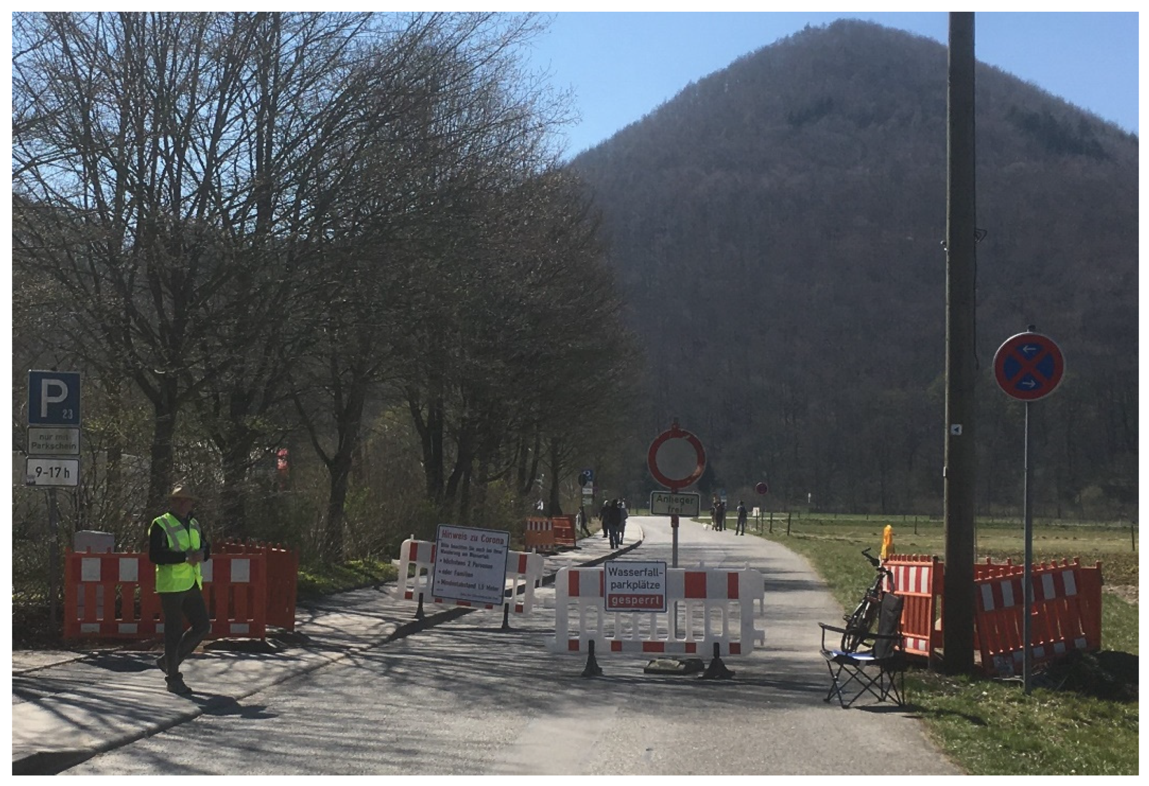
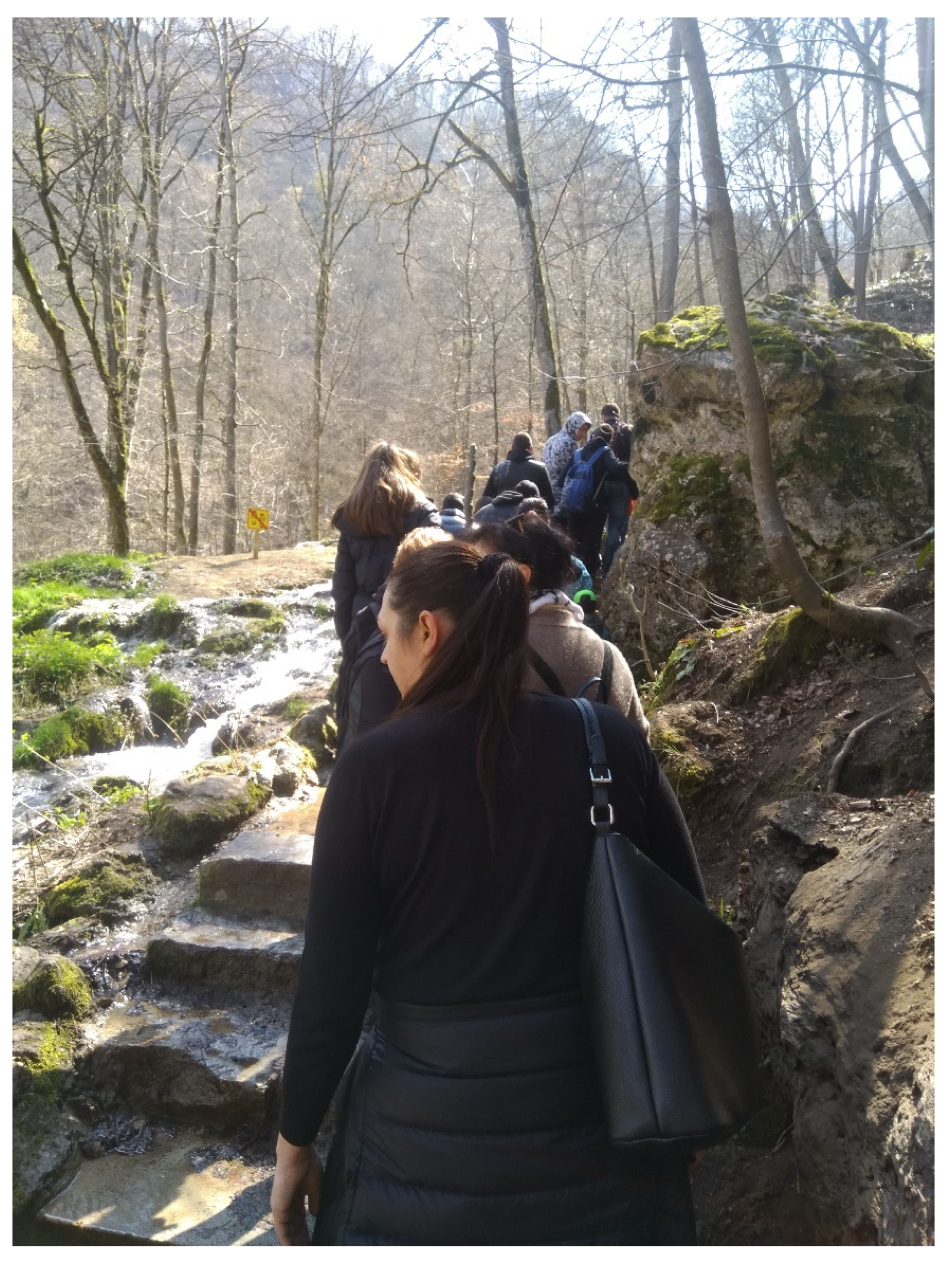
- Megerle, H.E. Calcerous Tufa as Invaluable Geotopes Endangered by (over-)Tourism: A Case Study in the UNESCO Global Geopark Swabian Alb, Germany. Geosciences 2021, 11, 198. [Google Scholar] [CrossRef]
- Cappadonia, C.; Coratza, P.; Agnesi, V.; Soldati, M. Malta and Sicily Joined by Geoheritage Enhancement and Geotourism within the Framework of Land Management and Development. Geosci. J. 2018, 8, 253. [Google Scholar] [CrossRef] [Green Version]
- Selmi, L.; Coratza, P.; Gauci, R.; Soldati, M. Geoheritage as a Tool for Environmental Management: A Case Study in Northern Malta (Central Mediterranean Sea). Resources 2019, 8, 168. [Google Scholar] [CrossRef] [Green Version]
- Tilden, F. Interpreting Our Heritage, 3rd ed.; The University of North Carolina Press: Chapel Hill, NC, USA, 1977; ISBN 0-8078-4016-5. [Google Scholar]
- Ham, S. Environmental Interpretation—A Practical Guide for People with Big Ideas and Small Budgets; North American Press: Golden, CO, USA, 1992; ISBN 1-55591-902-2. [Google Scholar]
- Knudson, D.; Cable, T.; Beck, L. Interpretation of Cultural and Natural Resources; Venture Publishing: Philadelphia, PA, USA, 1995; ISBN 978-0910251709. [Google Scholar]
- Brochu, L.; Merriman, T. Personal Interpretation: Connecting Your Audience to Heritage Resources, 3rd ed.; InterpPress: Fort Collins, CO, USA, 2015; ISBN 978-1879931329. [Google Scholar]
- Erfurt-Cooper, P. Volcanic Tourist Destinations (Geoheritage, Geoparks and Geotourism); Springer: Berlin/Heidelberg, Germany, 2014; ISBN 978-3642161902. [Google Scholar]
- Erfurt-Cooper, P. Active geothermal and volcanic environments as tourist destinations. In Global Geotourism Perspectives; Dowling, R., Newsome, D., Eds.; Goodfellow Publishers: Oxford, UK, 2010; pp. 33–38. ISBN 978-1906884178. [Google Scholar]
- Erfurt-Cooper, P.; Cooper, M. Volcano & Geothermal Tourism. Sustainable Geo-Ressources for Leisure and Recreation; Earthscan: New York, NY, USA, 2010; ISBN 978-1138994119. [Google Scholar]
- Óladóttir, O.Þ. Erlendir Ferðamenn á Íslandi 2018: Lýðfræði, Ferðahegðun og Viðhorf (International Visitors in Iceland 2018. Demography, Travel Behaviour and Attitudes); Icelandic Tourist Board: Reykjavík, Iceland, 2019. [Google Scholar]
- Qiao, X.; Du, J.; Lugli, S.; Ren, J.; Xiao, W.; Chen, P.; Tang, Y. Are climate warming and enhanced atmospheric deposition of sulfur and nitrogen threatening tufa landscapes in Jiuzhaigou National Nature Reserve, Sichuan, China? Sci. Total Environ. 2016, 562, 724–731. [Google Scholar] [CrossRef] [Green Version]
- Pentecost, A. Travertine; Springer: Dordrecht, The Netherlands, 2005; ISBN 978-1402035234. [Google Scholar]
- Megerle, H. Cultural values of geomorphosites within the Geopark Swabian Alb In Gestion des géosites dans les espaces protégés; Hoblea, F., Cayla, N., Reynard, E., Eds.; Université Savoie Mont Blanc; Collection EDYTEM, 15; Chambéry, France, 2014; pp. 149–154. [Google Scholar]
- Megerle, H.; Beuter, A. La protection des géotopes et le géotourisme–des intérêts contradictoires ou une préoccupation commune? In Les Géosciences au Service de la Société, Actes du Colloque en L’honneur du Professeur Michel Marthaler; Reynard, E., Laigre, L., Kramar, N., Eds.; Institut de Géographie, Université de Lausanne: Lausanne, Switzerland, 2011; pp. 76–90. ISBN 978-2-940368-12-9. [Google Scholar]
- Zhou, X.L. Influences of geological environment deterioration on Jiuzhaigou ravine landscape. Carstologica Sin. 1998, 3, 119–128. [Google Scholar]
- Zhang, J.; Wang, H.; Li, D.; Zhao, D. An analysis of travertine landscape degradation in Huanglong Ravine of Sichuan, a world’s heritage site, and its causes and protection countermesures. Acta Ecol. Sin. 2012, 1, 111–120. [Google Scholar]
- Liu, Z.H.; Tian, Y.P.; An, D.J.; Wang, H.J.; Tang, S.; Zhang, J.L.; Sun, H.; Liu, Y.; Zhang, Q.M. Formation and evolution of the travertine landscape at Huanglong, Sichuan, one of the world natural heritages. Acta Geosci. Sin. 2009, 30, 841–847. [Google Scholar]
- Sæþórsdóttir, A.; Hall, C.; Wendt, M. Overtourism in Iceland: Fantasy or Reality? Sustainability 2020, 12, 7375. [Google Scholar] [CrossRef]
- Ruede, D. Besuchsaufkommen und Corona. Available online: https://www.nationalpark-schwarzwald.de/fileadmin/Mediendatenbank_Nationalpark/04_Forschen/Sozialwissenschaftlich/20200805_Besuchsaufkommen_und_Corona_Rueede_Versand.pdf (accessed on 16 September 2021).
- Crofts, R. Putting Geoheritage Conservation on All Agendas. Geoheritage 2018, 10, 231–238. [Google Scholar] [CrossRef]
- Crofts, R.; Tormey, D.; Gordon, J. Introducing New Guidelines on Geoheritage Conservation in Protected and Conserved Areas. Geoheritage 2021, 13, 33. [Google Scholar] [CrossRef]
- Gregorič, A.C. Typical Doline and Surface Landforms of Kras (Slovenia): Karst Landscape Features and Possibilities for Their Conservation. Geoheritage 2021, 13, 26. [Google Scholar] [CrossRef]
- Wimbledon, W.; Smith-Meyer, S. (Eds.) Geoheritage in Europe and Its Conservation; ProGEO: Oslo, Norway, 2012; ISBN 978-82-426-2476-5. [Google Scholar]


| Strengths | Opportunities |
|
|
| Weaknesses | Threats |
|
|
Publisher’s Note: MDPI stays neutral with regard to jurisdictional claims in published maps and institutional affiliations. |
© 2022 by the author. Licensee MDPI, Basel, Switzerland. This article is an open access article distributed under the terms and conditions of the Creative Commons Attribution (CC BY) license (https://creativecommons.org/licenses/by/4.0/).
Share and Cite
Megerle, H.E. One Billion Years of Earth History: Challenges of Valorizing the Outstanding Geodiversity of Southwest Germany for Sustainable Geotourism. Sustainability 2022, 14, 559. https://doi.org/10.3390/su14010559
Megerle HE. One Billion Years of Earth History: Challenges of Valorizing the Outstanding Geodiversity of Southwest Germany for Sustainable Geotourism. Sustainability. 2022; 14(1):559. https://doi.org/10.3390/su14010559
Chicago/Turabian StyleMegerle, Heidi Elisabeth. 2022. "One Billion Years of Earth History: Challenges of Valorizing the Outstanding Geodiversity of Southwest Germany for Sustainable Geotourism" Sustainability 14, no. 1: 559. https://doi.org/10.3390/su14010559