
A Review on Snowmelt Models: Progress and Prospect


Abstract
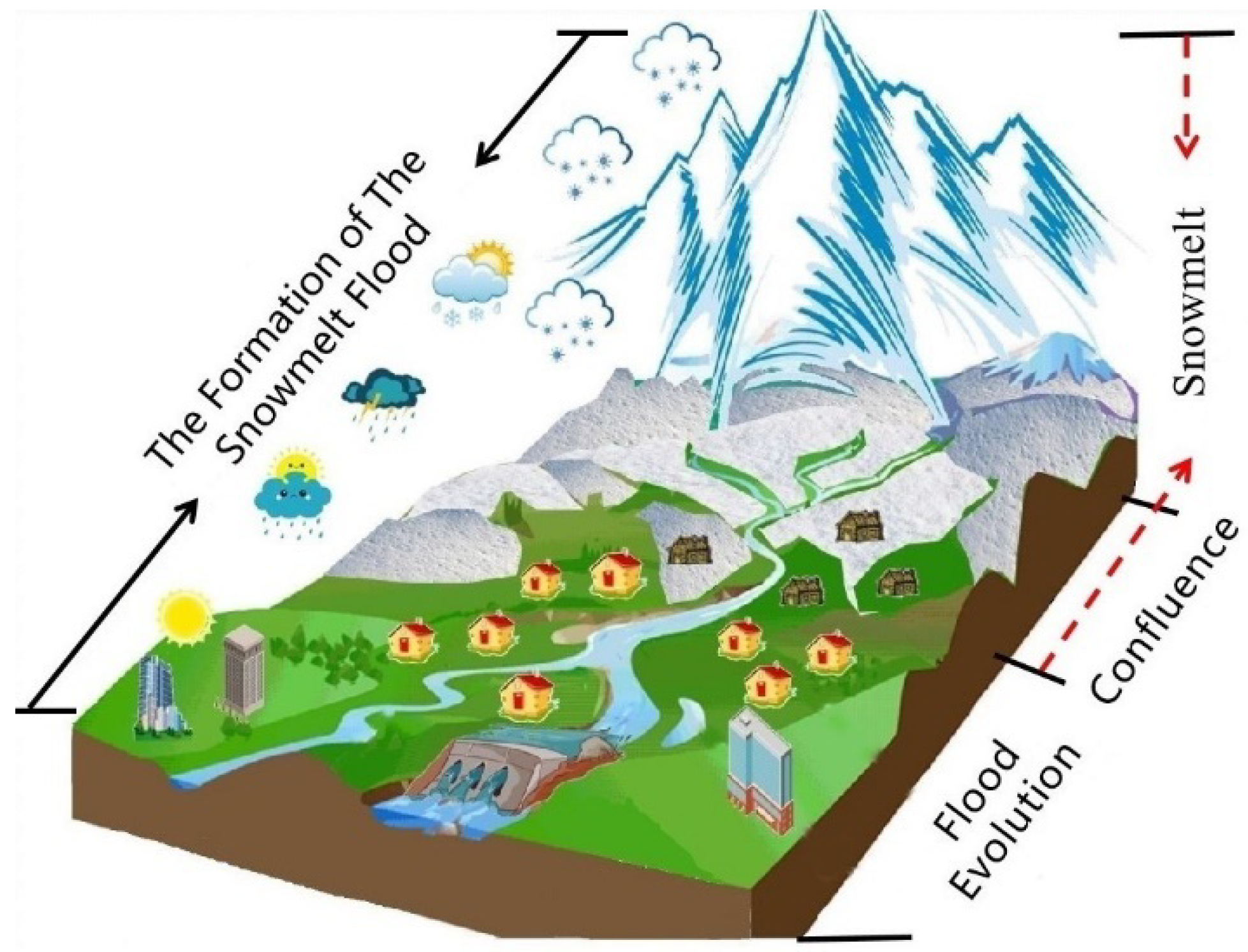
:1. Introduction
2. Snowmelt Modelling
2.1. Development History of Snowmelt Models
2.2. Categories of Snowmelt Models
2.3. Statistical Snowmelt Models
2.4. Conceptual Snowmelt Models
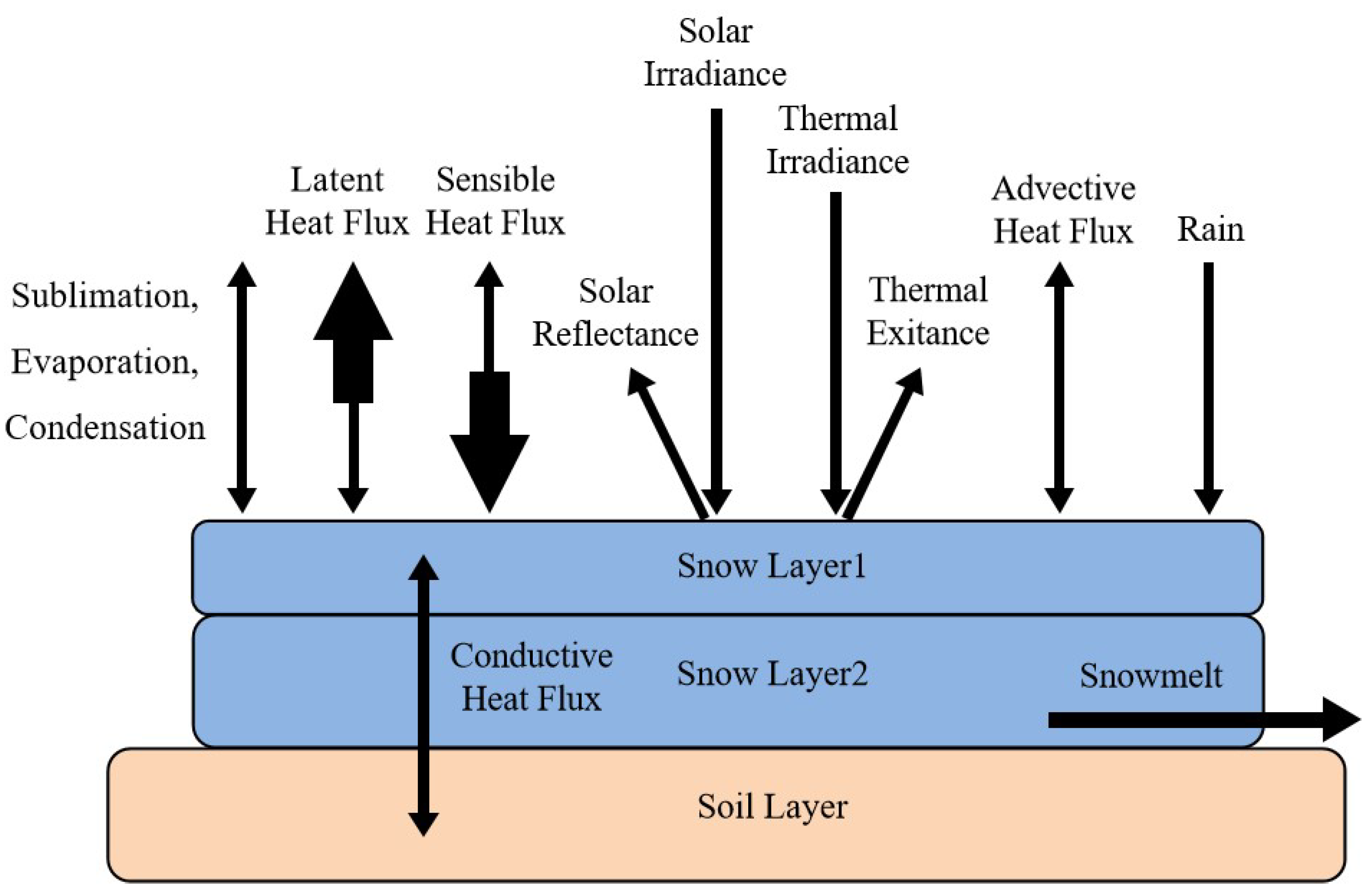
2.5. Physical Snowmelt Models
2.6. Data-Driven Model
3. Key Issues in the Snowmelt Model
3.1. Blowing Snow
3.2. Snow on Frozen Ground
3.3. Rain-on-Snow
3.4. Challenges of the Snowmelt Models
4. Summary
Author Contributions
Funding
Acknowledgments
Conflicts of Interest
References
- Teng, J.; Jakeman, A.J.; Vaze, J.; Croke, B.; Dutta, D.; Kim, S. Flood inundation modelling: A review of methods, recent advances and uncertainty analysis. Environ. Modell. Softw. 2017, 90, 201–216. [Google Scholar] [CrossRef]
- Merz, B.; Blschl, G.; Vorogushy, N.S.; Dottori, F.; Macdonald, E. Causes, impacts and patterns of disastrous river floods. Nat. Rev. Earth Environ. 2021, 2, 592–609. [Google Scholar] [CrossRef]
- Zou, Q.; Zhou, J.Z.; Zhou, C.; Guo, J. Fuzzy risk analysis of flood disasters based on diffused-interior-outer-set model. Expert Syst. Appl. 2012, 39, 6213–6220. [Google Scholar] [CrossRef]
- Chen, Y.N.; Li, Z.; Fan, Y.T.; Wang, H.J.; Fang, G.H. Research progress on the impact of climate change on water resources in the arid region of Northwest China. Acta Geogr. Sin. 2014, 69, 1295–1304. [Google Scholar]
- Chen, R.S.; Shen, Y.P.; Mao, W.Y.; Zhang, S.Q.; Lu, H.S.; Liu, Y.Q. Progress and issues on key technologies in forecasting of snowmelt flood disaster in arid areas, Norwest China. Adv. Earth Sci. 2021, 36, 233–244. [Google Scholar]
- Wang, H. Study on Three-Dimensional Visualization of Snowmelt Flood. Master’s Thesis, Shihezi University, Shihezi, China, 2016. [Google Scholar]
- Sun, Z.H.; Li, Y.T.; Chen, J.; Liu, Y. Analysis of flood damage reduction system in the middle Yangtze river(Ⅱ): Regional synthetic flood. Sci. Technol. Eng. 2007, 22, 5829–5835. [Google Scholar]
- Marks, D.; Kimball, J.; Tingey, D.; Link, T. The sensitivity of snowmelt processes to climate conditions and forest cover during rain-on-snow: A case study of the 1996 Pacific Northwest flood. Hydrol. Process. 2015, 12, 1569–1587. [Google Scholar] [CrossRef]
- Dewalle, D.R.; Rango, A. Principles of Snow Hydrology; Cambridge University Press: Cambridge, UK, 2011. [Google Scholar]
- Martinec, J. Snowmelt-Runoff Model for Stream Flow Forecasts. Hydrol. Res. 1975, 6, 145–154. [Google Scholar] [CrossRef]
- Martinec, J.; Rango, A. Parameter values for snowmelt runoff modelling. J. Hydrol. 1986, 84, 197–219. [Google Scholar] [CrossRef]
- Rango, A. The Snowmelt Runoff Model (SRM). In Computer Models of Watershed Hydrology; Singh, V.P., Ed.; Water Resources Pubications: Littleton, CO, USA, 1995; pp. 477–520. [Google Scholar]
- Dunkle, R.V.; Bevans, J.T. An Approximate Analysis of the Solar Reflectance and Transmittance of a Snow Cover. J. Meteorol. 1956, 13, 212–216. [Google Scholar] [CrossRef] [Green Version]
- Anderson, E.A. A point of energy and mass balance model of snow cover. NOAA Tech. Rep. NWS. 1976, 19, 138–144. [Google Scholar]
- Male, D.H.; Granger, R.J. Snow surface energy exchange. Water Resour. Res. 1981, 17, 609–627. [Google Scholar] [CrossRef]
- Jordan, R. A One-Dimensional Temperature Model for Snow Cover: Technical Documentation for SNTHERM.89; Special Report. 91–16; Cold Regions Research and Engineering Laboratory (U.S.): Hanover, NH, USA; Engineer Research and Development Center (U.S.): Vicksburg, MS, USA, 1991. [Google Scholar]
- Abbott, M.B.; Bathurst, J.C.; Cunge, J.A.; O’Connell, P.E.; Rasmussen, J. An introduction to the European Hydrological System—Systeme Hydrologique Europeen, “SHE”, 2: Structure of a physically-based, distributed modelling system. J. Hydrol. 1986, 87, 61–77. [Google Scholar] [CrossRef]
- Marks, D.; Dozier, J. Climate and energy exchange at the snow surface in the Alpine Region of the Sierra Nevada: 2. Snow cover energy balance. Water Resour. Res. 1992, 28, 3043–3054. [Google Scholar] [CrossRef]
- Tarboton, D.G.; Luce, C.H.; Service, U.F. Utah Energy Balance Snow Accumulation and Melt Model (UEB). In Computer Model Technical Description and Users Guide; Utah State University: Logan, UT, USA, 1996; pp. 1–66. [Google Scholar]
- Becknell, B.R.; Imhoff, J.C.; Kittle, J.L.; Donigian, A.S.; Johanson, R.C. Hydrological Simulation Program—FORTRAN User’s Manual for Release 12; Us Epa: Athens, Greece, 1997. [Google Scholar]
- Wigmosta, M.S.; Vail, L.W.; Lettenmaier, D.P. A distributed hydrology-vegetation model for complex terrain. Water Resour. Res. 1994, 30, 1665–1679. [Google Scholar] [CrossRef]
- Liang, X.; Lettenmaier, D.P.; Wood, E.F.; Burges, S.J. A simple hydrologically based model of land surface water and energy fluxes for general circulation models. J. Geophys. Res.-Atmos 1994, 99, 14415–14428. [Google Scholar] [CrossRef]
- Arnold, J.G.; Srinivasan, R.; Muttiah, R.S.; Williams, J.R. Large Area Hydrologic Modeling and Assessment Part I: Model Development. J. Am. Water Resour. Assoc. 1998, 34, 1–17. [Google Scholar] [CrossRef]
- Bartelt, P.; Lehning, M. A physical SNOWPACK model for the Swiss avalanche warning Part I: Numerical model. Cold Reg. Sci. Tech. 2002, 35, 123–145. [Google Scholar] [CrossRef]
- Bergström, S.; Singh, V.P. The HBV Model; Water Resources Pubilications: Highland Ranch, CO, USA, 1995; pp. 443–476. [Google Scholar]
- Vafakhah, M.; Sedighi, F.; Javadi, M.R. Modeling the Rainfall-Runoff Data in Snow-Affected Watershed. Int. J. Comput. Electr. Eng. 2014, 6, 40–43. [Google Scholar] [CrossRef]
- Thapa, S. Snowmelt-Driven Streamflow Prediction Using Machine Learning Techniques (LSTM, NARX, GPR, and SVR). Water 2020, 12, 1734. [Google Scholar] [CrossRef]
- Leavesley, G.H.; Stannard, L.G. The Precipitation-Runoff Modeling System—PRMS; Water Resources Pubilications: Highland Ranch, CO, USA, 1995; pp. 281–310. [Google Scholar]
- Wang, L.; Koike, T.; Yang, K.; Jackson, T.J.; Bindlish, R.; Yang, D. Development of a distributed biosphere hydrological model and its evaluation with the Southern Great Plains Experiments (SGP97 and SGP99). J. Geogr. Sci. 2009, 114. [Google Scholar] [CrossRef] [Green Version]
- Dewalle, D.R.; Eismeier, J.A.; Rango, A. Early Forecasts of Snowmelt Runoff using SNOTEL Data in the Upper Rio Grande Basin. In Proceedings of the 71st Annual Meeting of the Western Snow Conference, Scottsdale, Arizona, 23–24 April 2003; pp. 17–22. [Google Scholar]
- Finsterwalder, S.; Schunk, H. Der Suldenferner. Z. Des Dtsch. Und Oesterreichischen Alp. 1887, 18, 72–89. [Google Scholar]
- Hoinkesand, H.; Steinacker, R. Hydrometeorological Implications of the Mass Balance of Hintereisferner, 1952–1953 to 1968-69; IAHS-AISH: Moscow, Russia, 1971. [Google Scholar]
- Oerlemans, J.; Anderson, B.; Hubbard, A.; Huybrechts, P.; Jóhannesson, T.; Knap, W.H.; Schmeits, M.; Stroeven, A.P.; Wal, R.; Wallinga, J. Modelling the response of glaciers to climate warming. Clim. Dyn. 1998, 14, 267–274. [Google Scholar] [CrossRef] [Green Version]
- Liu, S.; Xie, Z.; Song, G.; Ma, L.; Ageta, Y. Mass balance of Kangwure (flat-top) Glacier on the north side of Mt. Xixiabangma, China. Bull. Glacier Res. 1996, 14, 37–43. [Google Scholar]
- Jóhannesson, T.; Sigurdsson, O.; Laumann, T.; Kennett, M. Degree-day glacier mass-balance modelling with applications to glaciers in Iceland, Norway and Greenland. J. Glaciol. 2017, 41, 345–358. [Google Scholar] [CrossRef] [Green Version]
- DeWalle, D.R.; Henderson, Z.; Rango, A. Spatial and temporal variations in snowmelt degree-day factors computed from snotel. In Proceedings of the 70th Annual Meeting of the Western Snow Conference, Granby, CO, USA, 20 May 2002; pp. 73–81. [Google Scholar]
- Zhang, Y.; Liu, S.Y.; Wang, X. A dataset of spatial distribution of degree-day factors for glaciers in High Mountain Asia. China Sci. Data 2019, 4, 141–151. [Google Scholar]
- Monroe, J.C.; Anderson, E.A. National Weather Service River Forecast System. J. Hydraul. Div. 1973, 100, 621–630. [Google Scholar] [CrossRef]
- Federer, C.A.; Lash, D. A Hydrologic Simulation Model for Eastern Forests; University of New Hampshire: Durham, NH, USA, 1978. [Google Scholar]
- Federer, C.A.; Pierce, R.S.; Hornbeck, J.W. Snow Management Seems Unlikely in the Northeast; American Water Resources, Association National Symposium on Watersheds in Transition: Urbana, IL, USA, 1972. [Google Scholar]
- Kuusisto, E. On the Values and Variability of Degree-Day Melting Factor in Finland. Hydrol. Res. 1980, 11, 235–242. [Google Scholar] [CrossRef]
- Singh, P.; Kumar, N. Determination of snowmelt factor in the Himalayan region. Hydrol. Sci. J. 1996, 41, 301–310. [Google Scholar] [CrossRef]
- Zuzel, J.F.; Cox, L.M. Relative importance of meteorological variables in snowmelt. Water Resour. Res. 1975, 11, 174–176. [Google Scholar] [CrossRef]
- Brubaker, K.; Rango, A.; Kustas, W. Incorporating radiation input into the Snowmelt Runooff Model. Hydrol. Process. 1996, 10, 1329–1343. [Google Scholar] [CrossRef]
- Morid, S. Snowmelt-Runoff Simulation for Snowbound Ungaugd Catchment. Ph.D. Thesis, Indian Institute of Technology, New Delhi, India, 2000. [Google Scholar]
- Morid, S.; Gosain, A.K.; Keshari, A.K. An algorithm for monitoring snow water equivalent in ungauged catchments using GIS. In Proceedings of the International Conference on Integrated Water Resources Management for Sustainable Development, New Delhi, India, 19–21 December 2000. [Google Scholar]
- Kustas, W.P.; Rango, A.; Uijlenhoet, R. A simple energy budget algorithm for the snowmelt runoff model. Water Resour. Res. 1994, 30, 1515–1527. [Google Scholar] [CrossRef]
- Cazorzi, F.; Fontana, G.D. Snowmelt modelling by combining air temperature and a distributed radiation index. J. Hydrol. 1996, 181, 169–187. [Google Scholar] [CrossRef]
- Hock, R. A distributed temperature-index ice- and snowmelt model including potential direct solar radiation. J. Glaciol. 1999, 45, 101–111. [Google Scholar] [CrossRef]
- Pellicciotti, F.; Brock, B.; Strasser, U.; Corripio, J.; Burlando, P.; Funk, M. The Distributed Application of an Enhanced Temperature-Index Melt Model Including Albedo and Global Radiation; American Geophysical Union, Fall Meeting, San Francisco, December, 2003; American Geophysical Union, Fall Meeting, AGU: San Francisco, CA, USA, 2003. [Google Scholar]
- Fang, S.F.; Pei, H.; Liu, Z.H.; Dai, W.; Zhai, Q.D. Study on the distributed snowmelt runoff process based on RS and GIS. J. Remote Sens. 2008, 12, 655–662. [Google Scholar]
- Jost, G.; Moore, R.D.; Smith, R.; Gluns, D.R. Distributed temperature-index snowmelt modelling for forested catchments. J. Hydrol. 2012, 420, 87–101. [Google Scholar] [CrossRef]
- Hock, R. Temperature Index Melt Modelling in Mountain Areas. J. Hydrol. 2003, 282, 104–115. [Google Scholar] [CrossRef]
- Muattar, S.; Ding, J.L.; Cui, C.L. Simulation and validation of enhanced snowmelt runoff model with topographic factor. Trans. Chin. Soc. Agric. Eng. 2017, 33, 179–186. [Google Scholar]
- Chen, R.S.; Lu, S.H.; Kang, E.S.; Ji, X.B.; Yang, Y.; Zhang, J.S. A Distributed Water-Heat Coupled (DWHC) Model for Mountainous W atershed of An Inland River Basin(Ⅰ): Model Structure and Equations. Adv. Earth Sci. 2006, 21, 806–818. [Google Scholar]
- Yang, D.; Herath, S.; Musiake, K. Development of a geomorphology-based hydrological model for large catchments. Proc. Hydraul. Eng. 1998, 42, 169–174. [Google Scholar] [CrossRef] [Green Version]
- Anderson, E.A. Development and testing of snow pack energy balance equations. Water Resour. Res. 1968, 4, 19–37. [Google Scholar] [CrossRef]
- Obled, C.H.; Harder, H. A review of snow melt in the mountain environment. In Proceedings of the on Modeling of Snow Cover Runoff, Hanover, NH, USA, 26–28 September 1978. [Google Scholar]
- Male, D.H.; Granger, R.J. Energy and mass fluxes at the snow surface in a Prairie environment. In Proceedings of the on Modeling of Snow Cover Runoff, Hanover, NH, USA, 26–28 September 1978. [Google Scholar]
- Gray, D.M.; Landine, P.G. An energy-budget snowmelt model for the Canadian Prairies. Can. J. Earth Sci. 1988, 25, 1292–1303. [Google Scholar] [CrossRef]
- Link, T.; Marks, D. Distributed simulation of snowcover mass- and energy-balance in the boreal forest. Hydrol. Process. 2015, 13, 2439–2452. [Google Scholar] [CrossRef]
- Steven, N.; Berris, R.; Dennis, H. Comparative snow accumulation and melt during rainfall in forested and clear-cut plots in the Western Cascades of Oregon. Water Resour. Res. 1987, 23, 135–142. [Google Scholar]
- Heng, L.U.; Wei, W.S.; Liu, M.; Han, X.; Hong, W. Energy budget over seasonal snow surface at an open site and beneath forest canopy openness during the snowmelt period in western Tianshan Mountains, China. J. Mt. Sci. 2015, 12, 298–312. [Google Scholar]
- Marks, D.; Winstral, A.; Flerchinger, G.; Reba, M.; Pomeroy, J.; Link, T.; Elder, K. Comparing Simulated and Measured Sensible and Latent Heat Fluxes over Snow under a Pine Canopy to Improve an Energy Balance Snowmelt Model. J. Hydrometeorol. 2008, 9, 1506–1522. [Google Scholar] [CrossRef]
- Pomeroy, J.W.; Essery, R. Turbulent fluxes during blowing snow: Field tests of model sublimation predictions. Hydrol. Process. 2015, 13, 2963–2975. [Google Scholar] [CrossRef]
- Bales, R.C.; Molotch, N.P.; Painter, T.H.; Dettinger, M.D.; Rice, R.; Dozier, J. Mountain hydrology of the western United States. Water Resour. Res. 2006, 42. [Google Scholar] [CrossRef]
- Guo, J.K.; Li, Z.; Li, F.; Zhang, S.Q. Evaluation on snow coverage and snow depth simulated by VIC-CAS modelbased on multi-source remote sensing data in mountainous upper reach of the Shule River basin. J. Glaciol. Geocryol. 2021, 43, 650–661. [Google Scholar]
- Cheng, B.; Titterington, D.M. Neural Networks—A Review from a Statistical Perspective. Inst. Math. Stat. 1994, 9, 2–30. [Google Scholar]
- Ranka, M.S. Forecasting the behavior of multivariate time series using neural networks. Neural Netw. 1992, 5, 961–970. [Google Scholar]
- Maier, H.R.; Dandy, G.C. Neural networks for the prediction and forecasting of water resources variables: A review of modelling issues and applications. Environ. Modell. Softw. 2000, 15, 101–124. [Google Scholar] [CrossRef]
- Tibshirani, R. Regression shrinkage and selection via the lasso: A retrospective. J. R. Stat. Soc. Ser. B-Stat. Methodol. 2011, 73, 267–288. [Google Scholar] [CrossRef]
- Smola, A.; Vapnik, V. Support vector regression machines. Adv. Neural Inf. Process. Syst. 1997, 28, 779–784. [Google Scholar]
- Koza, J.R. Genetic Programming: On the Programming of Computers by Means of Natural Selection; MIT Press: Cambridge, MA, USA, 1992. [Google Scholar]
- Chang, L.C.; Shen, H.Y.; Chang, F.J. Regional flood inundation nowcast using hybrid SOM and dynamic neural networks. J. Hydrol. 2014, 519, 476–489. [Google Scholar] [CrossRef]
- Breiman, L. Random Forests. Mach. Learn. 2001, 45, 5–32. [Google Scholar] [CrossRef] [Green Version]
- Snelson, E.; Ghahramani, Z. Sparse Gaussian Process Using Pseudo-inputs. Adv. Neural Inf. Process. Syst. 2006, 18, 1257–1264. [Google Scholar]
- Moradkhani, H.; Hsu, K.L.; Gupta, H.V.; Sorooshian, S. Improved streamflow forecasting using self-organizing radial basis function artificial neural networks. J. Hydrol. 2004, 295, 246–262. [Google Scholar] [CrossRef] [Green Version]
- Acar, R.; Elik, S.; Enocak, S. Modelling Snowmelt Runoff Using an Artificial Neural Network ANN Approach. In Proceedings of the 3rd International Conference on Advances in Civil, Structural and Mechanical Engineering (ACSM), Bangkok, Thailand, 28–29 December 2015. [Google Scholar]
- Kratzert, F.; Klotz, D.; Brenner, C.; Schulz, K.; Herrnegger, M. Rainfall–runoff modelling using Long Short-Term Memory (LSTM) networks. Hydrol. Earth Syst. Sci. 2018, 22, 6005–6022. [Google Scholar] [CrossRef] [Green Version]
- Sharma, V.; Yuden, K. Imputing Missing Data in Hydrology using Machine Learning Models. Int. J. Eng. Tech. Res. 2021, 10, 78–82. [Google Scholar]
- Pedro, A.; Bruno, K.; Oscar, L. Automatic gap-filling of daily streamflow time series in data-scarce regions using a machine learning algorithm. J. Hydrol. 2021, 598, 126454. [Google Scholar]
- Chivers, B.D.; Wallbank, J.; Cole, S.J.; Sebek, O.; Stanley, S.; Fry, M.; Leontidis, G. Imputation of missing sub-hourly precipitation data in a large sensor network: A machine learning approach. J. Hydrol. 2020, 588, 125126. [Google Scholar] [CrossRef]
- Zhang, L.; Li, X.; Zheng, D.; Zhang, K.; Ge, Y. Merging multiple satellite-based precipitation products and gauge observations using a novel double machine learning approach. J. Hydrol. 2021, 594, 125969. [Google Scholar] [CrossRef]
- Lazri, M.; Labadi, K.; Brucker, J.M.; Ameur, S. Improving satellite rainfall estimation from MSG data in Northern Algeria by using a multi-classifier model based on machine learning. J. Hydrol. 2020, 584, 124705. [Google Scholar] [CrossRef]
- Yu, P.S.; Yang, T.C.; Chen, S.Y.; Kuo, C.M.; Tseng, H.W. Comparison of random forests and support vector machine for real-time radar-derived rainfall forecasting. J. Hydrol. 2017, 552, 92–104. [Google Scholar] [CrossRef]
- Hou, J.; Huang, C.; Zhang, Y.; Guo, J.; Gu, J. Gap-Filling of MODIS Fractional Snow Cover Products via Non-Local Spatio-Temporal Filtering Based on Machine Learning Techniques. Remote Sens. 2019, 11, 90. [Google Scholar] [CrossRef] [Green Version]
- Buckingham, D.; Skalka, C.; Bongard, J. Inductive machine learning for improved estimation of catchment-scale snow water equivalent. J. Hydrol. 2015, 524, 311–325. [Google Scholar] [CrossRef]
- Bair, E.; Calfa, A.; Rittger, K.; Dozier, J. Using machine learning for real-time estimates of snow water equivalent in the watersheds of Afghanistan. The Cryosphere. 2018, 12, 1579–1594. [Google Scholar] [CrossRef] [Green Version]
- Araya, S.N.; Ghezzehei, T.A. Using Machine Learning for Prediction of Saturated Hydraulic Conductivity and Its Sensitivity to Soil Structural Perturbations. Water Resour. Res. 2019, 55, 5715–5737. [Google Scholar] [CrossRef]
- Li, P.; Zha, Y.; Shi, L.; Tso, C.M.; Zhang, Y.; Zeng, W. Comparison of the use of a physical-based model with data assimilation and machine learning methods for simulating soil water dynamics. J. Hydrol. 2020, 584, 124692. [Google Scholar] [CrossRef]
- Oliveira, V.; Rodrigues, A.F.; Morais, M.; Terra, M.; Mello, C. Spatiotemporal modeling of soil moisture in an Atlantic forest through machine learning algorithms. Eur. J. Soil Sci. 2021, 13123, 1–19. [Google Scholar]
- Hosseiny, H.; Nazari, F.; Smith, V.; Nataraj, C. A Framework for Modeling Flood Depth Using a Hybrid of Hydraulics and Machine Learning. Sci. Rep. 2020, 10, 1–14. [Google Scholar] [CrossRef]
- Hadzima-Nyarko, M.; Rabi, A.; Šperac, M. Implementation of Artificial Neural Networks in Modeling the Water-Air Temperature Relationship of the River Drava. Water Resour. Manag. 2014, 28, 1379–1394. [Google Scholar] [CrossRef]
- Feigl, M.; Lebiedzinski, K.; Herrnegger, M.; Schulz, K. Machine learning methods for stream water temperature prediction. Hydrol. Earth Syst. Sci. 2021, 25, 2951–2977. [Google Scholar] [CrossRef]
- Gokmen, T.; Vijay, S.; Tommaso, M.; Silvia, B. Flood Hydrograph Prediction Using Machine Learning Methods. Water 2018, 10, 968. [Google Scholar]
- Chen, C.; He, W.; Zhou, H.; Xue, Y.; Zhu, M. A comparative study among machine learning and numerical models for simulating groundwater dynamics in the Heihe River Basin, northwestern China. Sci. Rep. 2020, 10, 1–13. [Google Scholar]
- Teweldebrhan, A.T.; Schuler, T.V.; Burkhart, J.F.; Hjorth-Jensen, M. Coupled machine learning and the limits of acceptability approach applied in parameter identification for a distributed hydrological model. Hydrol. Earth Syst. Sci. 2020, 24, 4641–4658. [Google Scholar] [CrossRef]
- Kim, J.; Han, H.; Johnson, L.E.; Lim, S.; Cifelli, R. Hybrid machine learning framework for hydrological assessment. J. Hydrol. 2019, 577, 123913. [Google Scholar] [CrossRef]
- Shen, C.; Laloy, E.; Elshorbagy, A.; Albert, A.; Bales, J.; Chang, F.J.; Ganguly, S.; Hsu, K.L.; Kifer, D.; Fang, Z. HESS Opinions: Incubating deep-learning-powered hydrologic science advances as a community. Hydrol. Earth Syst. Sci. 2018, 22, 5639–5656. [Google Scholar] [CrossRef] [Green Version]
- Yang, S.; Yang, D.; Chen, J.; Santisirisomboon, J.; Zhao, B. A physical process and machine learning combined hydrological model for daily streamflow simulations of large watersheds with limited observation data. J. Hydrol. 2020, 590, 125206. [Google Scholar] [CrossRef]
- Herath, H.; Chadalawada, J.; Babovic, V. Hydrologically Informed Machine Learning for Rainfall-Runoff Modelling: Towards Distributed Modelling. Hydrol. Earth Syst. Sci. 2020, 25, 4373–4401. [Google Scholar] [CrossRef]
- Khandelwal, A.; Xu, S.; Li, X.; Jia, X.; Kumar, V. Physics Guided Machine Learning Methods for Hydrolog. arXiv 2021, arXiv:2012.02854. [Google Scholar]
- Okkan, U.; Ersoy, Z.B.; Kumanlioglu, A.A.; Fistikoglu, O. Embedding machine learning techniques into a conceptual model to improve monthly runoff simulation: A nested hybrid rainfall-runoff modeling. J. Hydrol. 2021, 598, 126433. [Google Scholar] [CrossRef]
- Karpatne, A.; Atluri, G.; Faghmous, J.H.; Steinbach, M.; Banerjee, A.; Ganguly, A.; Shekhar, S.; Samatova, N.; Kumar, V. Theory-Guided Data Science: A New Paradigm for Scientific Discovery from Data. IEEE Trans. Knowl. Data Eng. 2017, 29, 2318–2331. [Google Scholar] [CrossRef]
- Flood, I.; Kartam, N. Neural Networks in Civil Engineering. I: Principles and Understanding. J. Comput. Civ. Eng. 1994, 8, 131–148. [Google Scholar] [CrossRef]
- Wagener, T.; Sivapalan, M.; Troch, P.A.; McGlynn, B.L.; Harman, C.J.; Gupta, H.V.; Kumar, P.; Rao, P.S.C.; Basu, N.B.; Wilson, J.S. The future of hydrology: An evolving science for a changing world. Water Resour. Res. 2010, 46. [Google Scholar] [CrossRef]
- Macdonald, M.K.; Pomeroy, J.W.; Pietroniro, A. On the importance of sublimation to an alpine snow mass balance in the Canadian Rocky Mountains. Hydrol. Earth Syst. Sci. 2010, 14, 1401–1415. [Google Scholar] [CrossRef] [Green Version]
- Zhou, J.; Pomeroy, J.W.; Zhang, W.; Cheng, G.; Wang, G.; Chen, C. Simulating cold regions hydrological processes using a modular model in the west of China. J. Hydrol. 2014, 509, 13–24. [Google Scholar] [CrossRef] [Green Version]
- Pomeroy, J.W.; Gray, D.M.; Landine, P.G. The Prairie Blowing Snow Model: Characteristics, validation, operation. J. Hydrol. 1993, 144, 165–192. [Google Scholar] [CrossRef]
- Essery, R.; Long, L.; Pomeroy, J. A distributed model of blowing snow over complex terrain. Hydrol. Process. 1999, 13, 2423–2438. [Google Scholar] [CrossRef]
- Walmsley, J.L.; Salmon, J.R.; Taylor, P.A. On the application of a model of boundary-layer flow over low hills to real terrain. Bound. -Layer Meteorol. 1982, 23, 17–46. [Google Scholar] [CrossRef]
- Liston, G.E.; Sturm, M. A snow-transport model for complex terrain. J. Glaciol. 1998, 44, 498–516. [Google Scholar] [CrossRef] [Green Version]
- Lehning, M.; Voelksch, I.; Gustafsson, D.; Nguyen, T.A.; Staehli, M.; Zappa, M. ALPINE3D: A detailed model of mountain surface processes and its application to snow hydrology. Hydrol. Process. 2006, 20, 2111–2128. [Google Scholar] [CrossRef]
- Schneiderbauer, S.; Prokop, A. The atmospheric snow-transport model: SnowDrift3D. J. Glaciol. 2011, 57, 526–542. [Google Scholar] [CrossRef] [Green Version]
- Guyomarc’H, G.; Mérindol, L. Validation of an application for forecasting blowing snow. Ann. Glaciol. 1998, 26, 138–143. [Google Scholar] [CrossRef] [Green Version]
- Li, L.; Pomeroy, J.W. Probability of occurrence of blowing snow. J. Geophys. Res. Atmos. 1997, 102, 21955–21964. [Google Scholar] [CrossRef] [Green Version]
- Bowling, L.C.; Pomeroy, J.W.; Lettenmaier, D.P. Parameterization of Blowing-Snow Sublimation in a Macroscale Hydrology Model. J. Hydrometeorol. 2004, 5, 3. [Google Scholar] [CrossRef] [Green Version]
- Eidsvik, K.J.; Holstad, A.; Lie, I.; Utnes, T. A Prediction System for Local Wind Variations in Mountainous Terrain. Bound.-Layer Meteor. 2004, 112, 557–586. [Google Scholar] [CrossRef]
- Lehning, M.; Doorschot, J.; Bartelt, P. A snowdrift index based on SNOWPACK model calculations. Ann. Glaciol. 2000, 31, 382–386. [Google Scholar] [CrossRef] [Green Version]
- Xie, Z.; Hu, Z.; Ma, Y.; Sun, G.; Gu, L.; Liu, S.; Wang, Y.; Zheng, H.; Ma, W. Modeling Blowing Snow Over the Tibetan Plateau with the Community Land Model: Method and Preliminary Evaluation. J. Geophys. Res. Atmos. 2019, 124, 9332–9355. [Google Scholar] [CrossRef]
- Bernhardt, M.; Zaengl, G.; Liston, G.E.; Strasser, U.; Mauser, W. Using wind fields from a high-resolution atmospheric model for simulating snow dynamics in mountainous terrain. Hydrol. Process. 2010, 23, 1064–1075. [Google Scholar] [CrossRef]
- Grell, G.A.; Dudhia, J.; Stauffer, D.R. Description of the Fifth-Generation Penn State/NCAR Mesoscale Model (MM5); Technical Note NCAR/TN-398+STR; National Center for Atomospheric Research (NCAR): Boulder, CO, USA, 1994. [Google Scholar]
- Mott, R.; Lehning, M. Meteorological Modeling of Very High-Resolution Wind Fields and Snow Deposition for Mountains. J. Hydrometeorol. 2010, 11, 934–949. [Google Scholar] [CrossRef] [Green Version]
- Vionnet, V.; Martin, E.; Masson, V.; Guyomarc’h, G.; Lac, C. Simulation of wind-induced snow transport and sublimation in alpine terrain using a fully coupled snowpack/atmosphere model. Cryosphere 2014, 8, 395–415. [Google Scholar] [CrossRef] [Green Version]
- Winstral, A.; Elder, K.; Davis, R.E. Spatial Snow Modeling of Wind-Redistributed Snow Using Terrain-Based Parameters. J. Hydrometeorol. 2002, 3, 524–538. [Google Scholar] [CrossRef]
- Blôschl, G.; Kirnbauer, R.; Gutknecht, D. A spatially distributed snowmelt model for application in alpine terrain. In Snow, Hydrology and Forests in High Alpine Areas; Bergmann, H., Lang, H., Frey, W., Issler, D., Salm, B., Eds.; Proceedings of the Vienna Symposium, August 1991, IAHS publication No. 205; IAHS: Wallingford, UK, 1991; pp. 51–60. [Google Scholar]
- Purves, R.S.; Barton, J.S.; Mackaness, W.A.; Sugden, D.E. The development of a rule-based spatial model of wind transport and deposition of snow. Ann. Glaciol. 1998, 26, 197–202. [Google Scholar] [CrossRef] [Green Version]
- Hartman, M.D.; Baron, J.S.; Lammers, R.B.; Cline, D.W.; Band, L.E.; Liston, G.E.; Tague, C. Simulations of snow distribution and hydrology in a mountain basin. Water Resour. Res. 1999, 35, 1587–1603. [Google Scholar] [CrossRef] [Green Version]
- Adam, W.; Danny, M. Simulating wind fields and snow redistribution using terrain-based parameters to model snow accumulation and melt over a semi-arid mountain catchment. Hydrol. Process. 2002, 16, 1–19. [Google Scholar]
- Winstral, A.; Marks, D.; Gurney, R. Simulating wind-affected snow accumulations at catchment to basin scales. Adv. Water Resour. 2013, 55, 64–79. [Google Scholar] [CrossRef]
- Luo, L.; Robock, A.; Vinnikov, K.Y.; Schlosser, C.A.; Zeng, Q.C. Effects of Frozen Soil on Soil Temperature, Spring Infiltration, and Runoff: Results from the PILPS 2(d) Experiment at Valdai, Russia. J. Hydrometeorol. 2003, 4, 334–351. [Google Scholar] [CrossRef]
- Xin, L.; Koike, T. Frozen soil parameterization in SiB2 and its validation with GAME-Tibet observations. Cold Reg. Sci. Technol. 2003, 36, 165–182. [Google Scholar]
- Cherkauer, K.A.; Lettenmaier, D.P. Simulation of spatial variability in snow and frozen soil. J. Geophys. Res. Atmos. 2003, 108. [Google Scholar] [CrossRef]
- Niu, G.Y.; Yang, Z.L. Effects of Frozen Soil on Snowmelt Runoff and Soil Water Storage at a Continental Scale. J. Hydrometeorol. 2006, 7, 937–952. [Google Scholar] [CrossRef]
- Yamazaki, Y.; Kubota, J.; Ohata, T.; Vuglinsky, V.; Mizuyama, T. Seasonal changes in runoff characteristics on a permafrost watershed in the southern mountainous region of eastern Siberia. Hydrol. Process. 2010, 20, 453–467. [Google Scholar] [CrossRef]
- Zuzel, J.F.; Pikul, J.L.; Rasmussen, P.E. Tillage and Fertilizer Effects on Water Infiltration. Soil Sci. Soc. Am. J. 1990, 54, 205. [Google Scholar] [CrossRef]
- Harlan, R.L. Analysis of coupled heat-fluid transport in partially frozen soil. Water Resour. Res. 1973, 9, 1314–1323. [Google Scholar] [CrossRef] [Green Version]
- Flerchinger, G.N.; Hanson, C.L. Modeling Soil Freezing and Thawing on a Rangeland Watershed. Trans Asae 1989, 32, 1551–1554. [Google Scholar] [CrossRef]
- Murray; Gillies, J. Prediction of snowmelt infiltration into frozen soils. Fuel Energy Abstr. 1995, 36, 219. [Google Scholar]
- Cherkauer, K.A.; Lettenmaier, D.P. Hydrologic effects of frozen soils in the upper Mississippi River Basin. J. Geophys. Res. Atmos. 1999, 104, 19599–19610. [Google Scholar] [CrossRef]
- Gelfan, A. Physically based model of heat and water transfer in frozen soil and its parameterization by basic soil data, predictions in ungauged basins. Promises Prog. 2006, 303, 293–304. [Google Scholar]
- Stadler, D.; Flühler, H.; Jansson, P.E. Modelling vertical and lateral water flow in frozen and sloped forest soil plots. Cold Reg. Sci. Technol. 1997, 26, 181–194. [Google Scholar] [CrossRef]
- Jansson, P.E.; Halldin, S. Model for Annual Water and Energy Flow in a Layered Soil. Dev. Agric. Manag. For. Ecol. 1979, 9, 145–163. [Google Scholar]
- Jansson, P.E.; Moon, D.S. A coupled model of water, heat and mass transfer using object orientation to improve flexibility and functionality. Environ. Model. Softw. 2001, 16, 37–46. [Google Scholar] [CrossRef]
- Yang, Y.; Chen, R.S.; Ji, X.B.; Qing, W.W.; Liu, J.F.; Han, C.T. Heat and water transfer processes on alpine meadow frozen grounds of Heihe mountainous in Northwest China. Adv. Water Sci. 2010, 21, 30–35. [Google Scholar]
- Wang, Z.L.; Liu, C.X.; Jiang, Q.X.; Fu, Q.; Chen, W.J.; Ying, Y.M. Simulation of soil water-heat process in black soil region of Songnen Plain based on COUPMODEL. J. Northeast Agric. Univ. 2019, 50, 50–58. [Google Scholar]
- Zhang, Y.L.; Chang, X.L.; Liang, J.; He, R.X. Influence of frozen ground on hydrological processes in alpine regions: A case study in an upper reach of the Heihe River. J. Glaciol. Geocryol. 2016, 38, 1362–1372. [Google Scholar]
- Cao, W.; Sheng, Y.; Wu, J.C.; Wang, S.T.; Ma, S. Seasonal variation of soil hydrological processes of active layer in source region of the Yellow River. Adv. Water Sci. 2018, 29, 1–10. [Google Scholar]
- Yang, Y.; Chen, R.S. Research Review on Hydrology in the Permafrost and Seasonal Frozen Regions. Adv. Earth Sci. 2011, 26, 711–723. [Google Scholar]
- He, S.W.; Nan, Z.T.; Zhang, L.; Yu, W.J. Spatial-temporal distribution of water and energy fluxes in the upper reaches of the Heihe River simulated with VIC model. J. Glaciol. Geocryol. 2015, 37, 211–225. [Google Scholar]
- Wang, L.; Koike, T.; Yang, K.; Jin, R.; Li, H. Frozen soil parameterization in a distributed biosphere hydrological model. Hydrol. Earth Syst. Sci. 2010, 14, 557–571. [Google Scholar] [CrossRef] [Green Version]
- Pohl, S.; Davison, B.; Marsh, P.; Pietroniro, A. Modelling spatially distributed snowmelt and meltwater runoff in a small Arctic catchment with a hydrology land-surface scheme (WATCLASS). Atmos.-Ocean 2005, 43, 193–211. [Google Scholar] [CrossRef]
- Kattelmann, R. Macropores in Snowpacks of Sierra Nevada. Ann. Glaciol. 2017, 6, 272–273. [Google Scholar] [CrossRef] [Green Version]
- Harr, R.D. Some characteristics and consequences of snowmelt during rainfall in western Oregon. J. Hydrol. 1981, 53, 277–304. [Google Scholar] [CrossRef]
- Sui, J.; Koehler, G. Rain-on-snow induced flood events in Southern Germany. J. Hydrol. 2001, 252, 205–220. [Google Scholar] [CrossRef]
- Merz, R.; Blôschl, G. A process typology of regional floods. Water Resour. Res. 2003, 39. [Google Scholar] [CrossRef]
- Li, D.; Lettenmaier, D.P.; Margulis, S.A.; Andreadis, K. The Role of Rain on snow in Flooding Over the Conterminous United States. Water Resour. Res. 2019, 55, 8492–8513. [Google Scholar] [CrossRef] [Green Version]
- White, A.B.; Moore, B.J.; Gottas, D.J.; Neiman, P.J. Winter Storm Conditions Leading to Excessive Runoff above California’s Oroville Dam during January and February 2017. Bull. Amer. Meteorol. Soc. 2018, 100, 55–70. [Google Scholar] [CrossRef]
- Cohen, J.; Ye, H. Trends and variability in rain-on-snow events. Geophys. Res. Lett. 2015, 42, 7115–7122. [Google Scholar] [CrossRef] [Green Version]
- Mccabe, G.J.; Hay, L.E.; Clark, M.P. Rain-on-Snow Events in the Western United States. Bull. Amer. Meteorol. Soc. 2007, 88, 319–328. [Google Scholar] [CrossRef]
- Pall, P.; Tallaksen, L.M.; Stordal, F. A Climatology of Rain-on-Snow Events for Norway. J. Clim. 2019, 32, 6995–7016. [Google Scholar] [CrossRef]
- Bieniek, P.A.; Bhatt, U.S.; Walsh, J.E.; Rick, L.; Brad, G.; Roach, J.K.; Thoman, R.L. Assessment of Alaska rain-on-snow events using dynamical downscaling. J. Appl. Meteorol. Climatol. 2018, 57, 1847–1863. [Google Scholar] [CrossRef]
- Jeong, D.I.; Sushama, L. Rain-on-snow events over North America based on two Canadian regional climate models. Clim. Dyn. 2018, 50, 303–316. [Google Scholar] [CrossRef] [Green Version]
- Musselman, K.N.; Flavio, L.; Kyoko, I.; Clark, M.P.; Prein, A.F.; Liu, C.; Mike, B.; Roy, R. Projected increases and shifts in rain-on-snow flood risk over western North America. Nat. Clim. Chang. 2018, 8. [Google Scholar] [CrossRef]
- Qu, S.M.; Liu, H.; Cui, Y.P.; Shi, P.; Bao, W.M.; Yu, Z.B. Test of newly developed conceptual hydrological model for simulation of rain-on-snow events in forested watershed. Water Sci. Eng. 2013, 6, 31–43. [Google Scholar]
- Kattelmann, R. Flooding from rain-on-snow events in the Sierra Nevada. In Destructive Water: Water-Caused Natural Disasters, Their Abatement and Control; IAHS Publication: Oxfordshire, UK, 1997; pp. 59–65. [Google Scholar]
- Singh, P.; Spitzbart, G.; Hübl, H.; Weinmeister, H.W. Hydrological response of snowpack under rain-on-snow events: A field study. J. Hydrol. 1997, 202, 1–20. [Google Scholar] [CrossRef]
- Surfleet, C.G.; Tullos, D. Variability in effect of climate change on rain-on-snow peak flow events in a temperate climate. J. Hydrol. 2013, 479, 24–34. [Google Scholar] [CrossRef] [Green Version]
- Ye, H.; Yang, D.; Robinson, D. Winter rain on snow and its association with air temperature in northern Eurasia. Hydrol. Process. 2010, 22, 2728–2736. [Google Scholar] [CrossRef] [Green Version]
- Freudiger, D.; Kohn, I.; Stahl, K.; Weiler, M. Large-scale analysis of changing frequencies of rain-on-snow events with flood-generation potential. Hydrol. Earth Syst. Sci. 2014, 18, 2695–2709. [Google Scholar] [CrossRef]
- Ohba, M.; Kawase, H. Rain-on-Snow events in Japan as projected by a large ensemble of regional climate simulations. Clim. Dyn. 2020, 55, 1–16. [Google Scholar] [CrossRef]
- Melgar, D.O.; Meza, F.J. Exploring the Fingerprints of Past Rain-on-Snow Events in a Central Andean Mountain Range Basin Using Satellite Imagery. Remote Sens. 2020, 12, 4173. [Google Scholar] [CrossRef]
- Conway, H.; Benedict, R. Infiltration of water into snow. Water Resour. Res. 1994, 30, 641–649. [Google Scholar] [CrossRef]
- Marshall, H.P.; Conway, H.; Rasmussen, L.A. Snow densification during rain. Cold Reg. Sci. Technol. 1999, 30, 35–41. [Google Scholar] [CrossRef]
- Pradhanang, S.M.; Frei, A.; Zion, M.; Schneiderman, E.M.; Steenhuis, T.S.; Donald, P. Rain-on-snow runoff events in New York. Hydrobiol. Process. 2014, 27, 3035–3049. [Google Scholar] [CrossRef]
- Juras, R.; Pavlásek, J.; Vitvar, T.; Martin, S.; Holub, J.; Jankovec, J.; Linda, M. Isotopic tracing of the outflow during artificial rain-on-snow event. J. Hydrol. 2016, 541, 1145–1154. [Google Scholar] [CrossRef]
- Eiriksson, D.; Whitson, M.; Luce, C.H.; Marshall, H.P.; Bradford, J.; Benner, S.G.; Black, T.; Hetrick, H.; Mcnamara, J.P. An evaluation of the hydrologic relevance of lateral flow in snow at hillslope and catchment scales. Hydrol. Process. 2013, 27, 640–654. [Google Scholar] [CrossRef]
- Lundberg, A.; Granlund, N.; Gustafsson, D. Towards automated ‘Ground truth’ snow measurements-a review of operational and new measurement methods for Sweden, Norway, and Finland. Hydrol. Process. 2010, 24, 1955–1970. [Google Scholar] [CrossRef]
- Desilets, D.; Zreda, M.; Ferre, T.P.A. Nature’s neutron probe: Land surface hydrology at an elusive scale with cosmic rays. Water Resour. Res. 2010, 46, W11505.1–W11505.7. [Google Scholar] [CrossRef]
- Kodaira, N.; Inada, M. Measurement of Snowfall Intensity by Radar. Pap. Meteorol. Geophys. 2012, 6, 126–129. [Google Scholar] [CrossRef]
- Gutmann, E.D.; Larson, K.M.; Williams, M.W.; Nievinski, F.G.; Zavorotny, V. Snow measurement by GPS interferometric reflectometry: An evaluation at Niwot Ridge, Colorado. Hydrol. Process. 2012, 26, 2951–2961. [Google Scholar] [CrossRef]
- Zahmatkesh, Z.; Jha, S.K.; Coulibaly, P.; Stadnyk, T. An overview of river flood forecasting procedures in Canadian watersheds. Water News A Propos De L’eau 2019, 44, 213–229. [Google Scholar] [CrossRef]
- Kanamitsu, M.; Ebisuzaki, W.; Woollen, J.; Yang, S.K.; Hnilo, J.J.; Fiorino, M.; Potter, G.L. NCEP–DOE AMIP-II Reanalysis (R-2). Bull. Am. Meteorol. Soc. 2002, 83, 1631–1643. [Google Scholar] [CrossRef]
- Skamarock, W.C.; Klemp, J.B.; Dudhia, J.; Gill, D.O.; Powers, J.G. A Description of the Advanced Research WRF Version 2. Ncar Tech. 2005. [Google Scholar] [CrossRef]
- Palmer, T.N.; Barkmeijer, J.; Buizza, R.; Petroliagis, T. The ECMWF ensemble prediction system. Meteorlogical Appl. 1997, 4, 301–304. [Google Scholar] [CrossRef] [Green Version]
- Shen, X.S.; Wang, J.J.; Li, Z.C.; Chen, D.H.; Gong, J.D. China’s independent and innovative development of numerical weather prediction. Acta Meteorol. Sin. 2020, 78, 451–476. [Google Scholar]
- Chen, Y.N.; Yang, Q.; Luo, Y.; Shen, Y.J.; Pan, X.L.; Li, L.H.; Li, Z.Q. Ponder on the issues of water resources in the arid region of northwest China. Arid Land Geogr. 2012, 35, 1–9. [Google Scholar]
- Zhou, Y.L.; Mu, Z.X.; Peng, L.; Yin, Z.Y.; Tang, R. Change of snowmelt runoff in western Tianshan Mountains under future climate scenarios. J. China Hydrol. 2018, 38, 12–17. [Google Scholar]
- Zhang, L.; Wang, C.Y.; Pan, X.D. A review of future climate change based on regional climate models. Plateau Meteorol. 2018, 37, 1440–1448. [Google Scholar]


| Improvement Category | Targeting Problem | Improvement Strategy | References |
|---|---|---|---|
| Improvement of degree-day factor | The value of the degree-day factor can be affected by the state of snow, forest cover, terrain, snow pollution, etc. | Divide the sub-regions according to a certain characteristic of the watershed, and enter the degree-day factors with temporal and spatial differences. | [11,38,39,40,41,42] |
| Increase degree items | The degree-day factor based on the temperature index cannot represent all the energy sources in the process of snow melting. | Further consider the energy source of snow melting through addition of parameters including solar radiation, wind speed, water vapor pressure, etc. | [10,43,44,45,46,47] |
| Change the model structure | Temporal and spatial resolution of the degree-day factor model is insufficient. | Establish a distributed-degree-time model based on digital elevation data (DEM) and spatial data of temperature and radiation. | [48,49,50,51,52] |
| Model | Category | Spatiotemporal Resolution | Snow Melting Algorithm | Frozen Ground Consideration | Blowing Snow Consideration | Pros and Cons | References |
|---|---|---|---|---|---|---|---|
| SRM | Lumped, Conceptual | Daily, Elevation zone | Degree-Day | N | N | Less input data, less model parameters, flexible and easy to use, but it has high simulation accuracy, which is suitable for the snowmelt runoff forecast in mountainous areas with a lack of data, the forecast period is not precise enough | [11] |
| HBV | Semi-distributed, Conceptual | Daily, Elevation zone | Degree-Day | N | N | Less input data, less model parameters, flexible and easy to use. Used for hydrological forecasting of glaciers and snow-covered fields; lack of physical process research | [25] |
| SWAT | Semi-distributed, Physical | Daily, HRU | Degree-Day | N | N | Is widely used and becoming mature, and the simulation accuracy is high. Facing the long-term scale of large and medium watersheds; however, it has high requirements for input data and parameters, and it is difficult to apply in areas where monitoring data is lacking | [23] |
| GBHM | Distributed, Physical | Daily, Hillslope-based | Degree-Day | N | N | The application of the slope flow hydrological unit can better simulate the natural runoff process of the watershed. The model parameters have clear physical meanings and greatly reduce the amount of model calculations. It is suitable for the simulation calculation of the complete hydrological process of large and medium-scale watersheds in mountainous areas | [56] |
| DWHC | Distributed, Physical | Daily, Grid | Degree-Day | Y | N | The model has few adjustable parameters and input variables. It only needs conventional meteorological data and basic soil and vegetation parameters to continuously calculate the hydrological cycle elements such as the temperature and liquid water content of each layer of soil. Suitable for inland river areas in alpine mountainous areas; the model adopts a simplified method for many processes, which reduce the rigor of the physical process of the model | [55] |
| SNTHERM | point-scale, Physical | Hourly, point-scale | Energy Budget | Y | N | Is based on a more sophisticated physical basis and can well simulate various characteristic parameters on the snow profile, including snow depth, density, particle size and temperature. These parameters happen to be the input parameters required by the microwave remote sensing radiation transmission model. Can better simulate the temperature layer of the snow layer and frozen soil layer | [16] |
| SNOWPACK | point-scale, Physical | Hourly, point-scale | Energy Budget | N | Y | Only four micro-structure parameters can be used to describe the complex snow structure and simulate the change characteristics of the internal structure of the snow, but the snow water equivalent data cannot be obtained, and it is difficult to simulate the snowmelt runoff. Suitable for mountain avalanche prediction | [24] |
| PRMS | Semi-distributed, Physical | Hourly, HRU | Energy Budget | N | N | With a variety of simulation functions, it can simulate changes, in water balance, flood peaks and peak discharges, soil water, etc., in the processes of general precipitation, extreme precipitation and snow melting. The physical processes involved are also more comprehensive | [28] |
| DHSVM | Distributed, Physical | Hourly, Grid | Energy Budget | N | N | The model fully reflects the interaction and feedback mechanisms of climate, vegetation, snow cover, soil, and hydrology. However, it has high requirements for input data and parameters, and it is difficult to apply in areas where monitoring data are lacking. | [21] |
| SHE | Distributed, Physical | Hourly, Grid | Energy Budget | N | N | The model is very powerful, and software development is very mature. It can simulate all major hydrological processes in the terrestrial water cycle, including water movement, water quality, and sediment transportation; however, the model requires high input data, too many parameters, and a large amount of calculation. | [17] |
| VIC | Distributed, Physical | Hourly, Grid | Energy Budget | Y | N | It is widely used in soil moisture simulation, runoff forecasting, climate change impact analysis, and land use change impact analysis. It is suitable for large-scale land surface process simulation; however the assumptions made by the model conform to the characteristics of plain watersheds, not mountain watersheds. | [22] |
| UEB | Distributed, Physical | Hourly, Grid | Energy Budget | N | Y | No calibration is required, and fewer variables and parameters are required. However, there is a big difference between the simulated snow internal energy and the monitored data, and there are also problems in the parameterization of the turbulent flux. | [19] |
| Model | Model Input | Processes Considered | Applicability | References |
|---|---|---|---|---|
| PBSM | Wind speed, wind direction, air temperature, humidity, land use type | Blowing snow transportation, snow accumulation, snow erosion, blowing snow sublimation | Blowing snow in flat area | [109] |
| Snowtran-3D | Vegetation type, terrain, air temperature, humidity, precipitation, wind speed, wind direction | Blowing snow transportation, vegetation snow catching, wind speed and terrain changes, snow shear strength, wind-induced surface shear stress, suspended snow, snow erosion, blowing snow sublimation | Blowing snow in Alpine | [112] |
| SnowDrift-3D | Wind speed, wind direction, terrain, air temperature, humidity, precipitation | Snow transportation, snow accumulation, snow shear strength, wind-induced surface shear stress, snow erosion | Blowing snow in the mountains | [114] |
| Alpine3D | Wind speed, wind direction, precipitation, solar radiation, soil moisture, vegetation information | Blowing snow transportation, snow accumulation, snow erosion, blowing snow sublimation | Snow process and avalanche on steep mountain surface | [113] |
| Aspect | Challenges |
|---|---|
| 1. Data | 1.1 High-resolution data (air temperature, precipitation, snow, vegetation, soil moisture, etc.) 1.2 Accurate snow related estimation (snow cover, snow depth, snow water equivalent, etc.) 1.3 Fusion of different data sets and accuracy evaluation |
| 2. Model | 2.1 Data assimilation 2.2 The reliability test of runoff simulation 2.3 Process modeling of rain on snow and river ice 2.4 Coupling blowing snow, frozen ground, rain-on-snow 2.5 Coupling with atmospheric model 2.6 Deep learning algorithms |
| 3. Forecast and early warning | 3.1 High-resolution, accurate weather forecast 3.2 Uncertainty of weather forecast 3.3 Uncertainty of Snow algorithm 3.4 Robustness of the snowmelt model to floods of different scales |
| 4. Prediction and estimation | 4.1 Uncertainty of climate change scenarios 4.2 Uncertainty of downscaling method 4.3 New phenomena such as ROS under rapid heating Carbon black, aerosol, etc. |
Publisher’s Note: MDPI stays neutral with regard to jurisdictional claims in published maps and institutional affiliations. |
© 2021 by the authors. Licensee MDPI, Basel, Switzerland. This article is an open access article distributed under the terms and conditions of the Creative Commons Attribution (CC BY) license (https://creativecommons.org/licenses/by/4.0/).
Share and Cite
Zhou, G.; Cui, M.; Wan, J.; Zhang, S. A Review on Snowmelt Models: Progress and Prospect. Sustainability 2021, 13, 11485. https://doi.org/10.3390/su132011485
Zhou G, Cui M, Wan J, Zhang S. A Review on Snowmelt Models: Progress and Prospect. Sustainability. 2021; 13(20):11485. https://doi.org/10.3390/su132011485
Chicago/Turabian StyleZhou, Gang, Manyi Cui, Junhong Wan, and Shiqiang Zhang. 2021. "A Review on Snowmelt Models: Progress and Prospect" Sustainability 13, no. 20: 11485. https://doi.org/10.3390/su132011485