Dynamic Changes in Carbon Sequestration from Opencast Mining Activities and Land Reclamation in China’s Loess Plateau


Abstract
:1. Introduction
2. Material and Methods
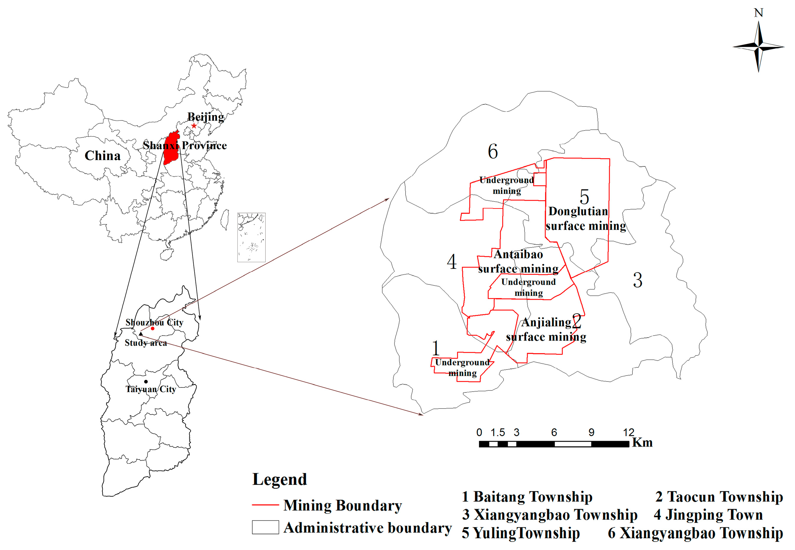
2.1. Study Area
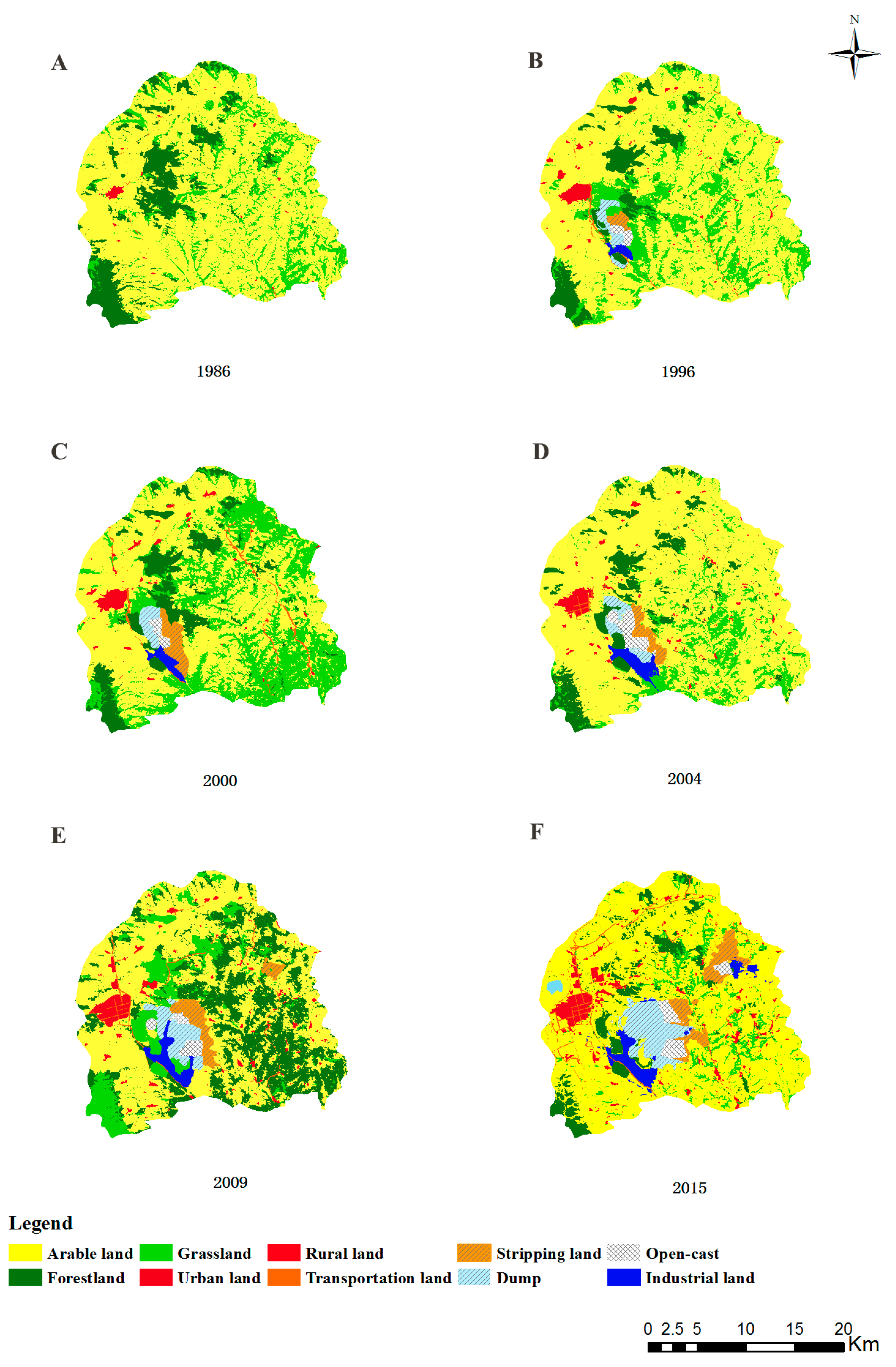
2.2. Data Source
2.3. Methods
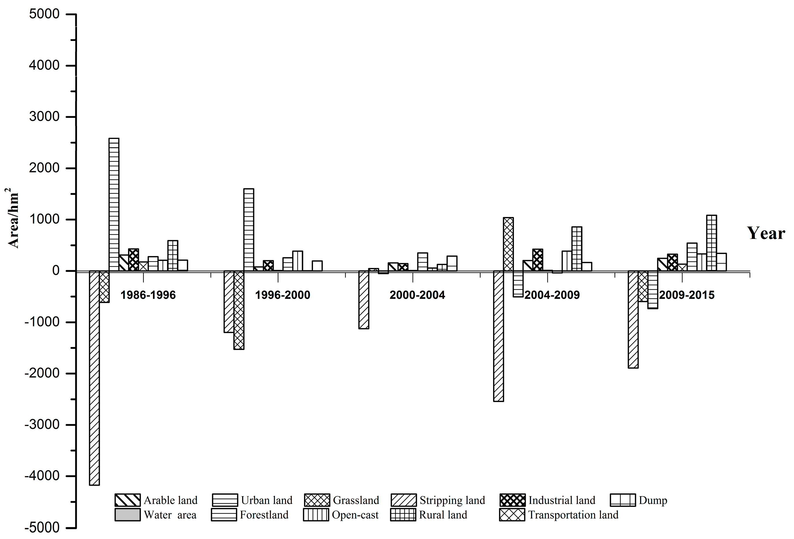
3. Result and Analysis
3.1. Soil Carbon Sequestration
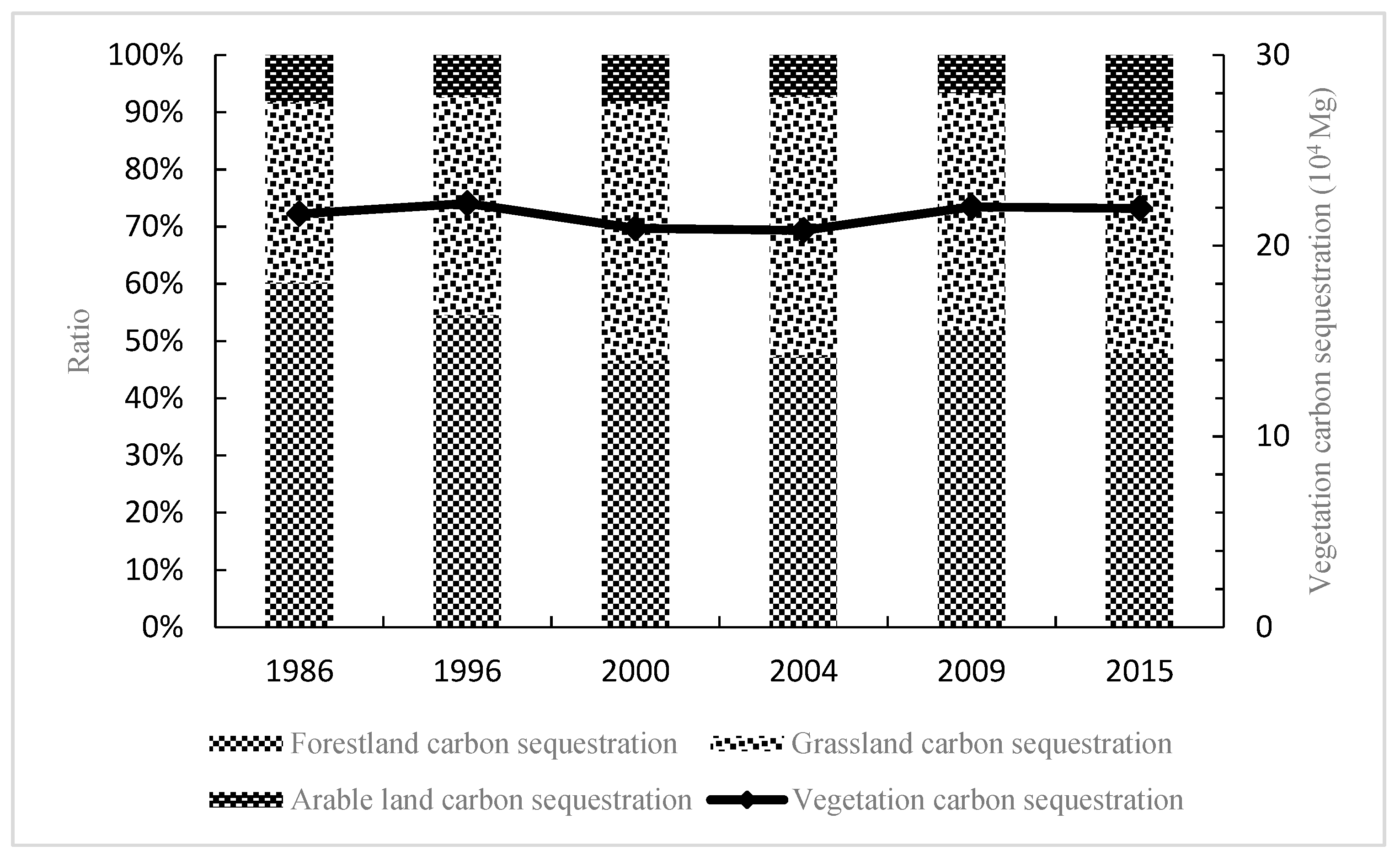
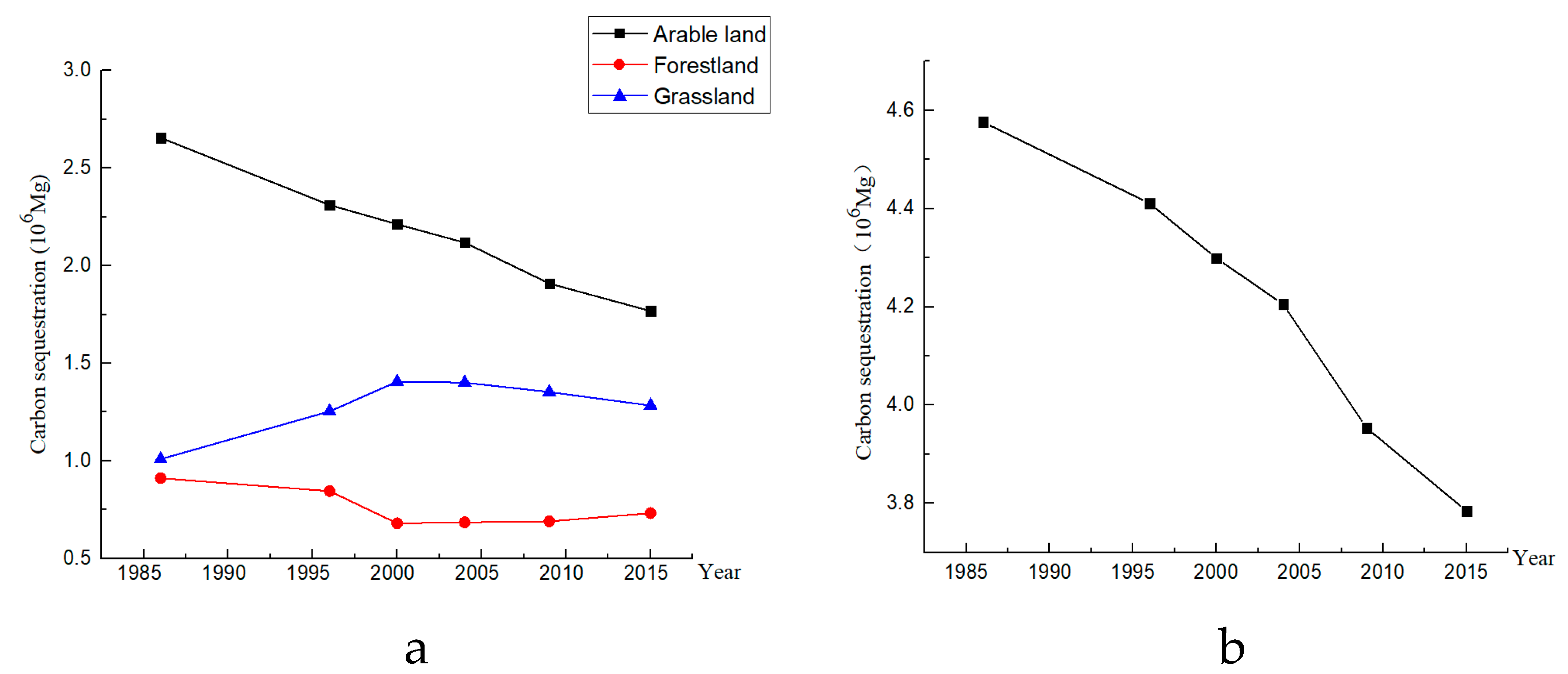
3.2. Vegetation Carbon Sequestration
3.3. The Total Carbon Sequestration
4. Discussion
4.1. The Impact of Mining Activities on Carbon Sequestration
4.2. The Impact of Vegetation Type and Soil Quality on Carbon Sequestration
4.3. The Guiding Significance of Carbon Sequestration on Land Use
5. Conclusions
Author Contributions
Funding
Acknowledgments
Conflicts of Interest
References
- Lai, L.; Huang, X.J.; Yang, H.; Chuai, X.W.; Zhang, M.; Zhong, T.Y.; Chen, Z.G.; Chen, Y.; Wang, X.; Thompson, J.R. Carbon emissions from land-use change and management in China between 1990 and 2010. Sci. Adv. 2016, 2, e1601063. [Google Scholar] [CrossRef] [PubMed] [Green Version]
- Shao, S.; Liu, J.; Geng, Y.; Miao, Z.; Yang, Y. Uncovering driving factors of carbon emissions from China’s mining sector. Appl. Energy 2016, 166, 220–238. [Google Scholar] [CrossRef]
- Das, R.; Maiti, S.K. Importance of carbon fractionation for the estimation of carbon sequestration in reclaimed coalmine soils—A case study from Jharia coalfields, Jharkhand, India. Ecol. Eng. 2016, 90, 135–140. [Google Scholar] [CrossRef]
- Pandey, V.C.; Sahu, N.; Behera, S.K.; Singh, N. Carbon sequestration in fly ash dumps: Comparative assessment of three plant association. Ecol. Eng. 2016, 95, 198–205. [Google Scholar] [CrossRef]
- del Mar Montiel-Rozas, M.; Panettieri, M.; Madejón, P.; Madejón, E. Carbon Sequestration in Restored Soils by Applying Organic Amendments. Land Degrad. Dev. 2016, 27, 620–629. [Google Scholar] [CrossRef]
- Lal, R.; Follett, R.F.; Kimble, J.M. Achieving Soil Carbon Sequestration in the United States: A Challenge to the Policy Makers. Soil Sci. 2003, 168, 827–845. [Google Scholar] [CrossRef]
- Longmire, A.; Taylor, C.; Pearson, C.J. An open-access method for targeting revegetation based on potential for emissions reduction, carbon sequestration and opportunity cost. Land Use Policy 2015, 42, 578–585. [Google Scholar] [CrossRef]
- Alberti, G.; Leronni, V.; Piazzi, M.; Petrella, F.; Mairota, P.; Peressotti, A.; Piussi, P.; Valentini, R.; Gristina, L.; La Mantia, T.; et al. Impact of woody encroachment on soil organic carbon and nitrogen in abandoned agricultural lands along a rainfall gradient in Italy. Reg Environ. Chang. 2011, 11, 917–924. [Google Scholar] [CrossRef] [Green Version]
- La Mantia, J.; Klapste, J.; El-Kassaby, Y.A.; Azam, S.; Guy, R.D.; Douglas, C.J.; Mansfield, S.D.; Hamelin, R. Association Analysis Identifies Melampsora xcolumbiana Poplar Leaf Rust Resistance SNPs. PLoS ONE 2013, 8, e78423. [Google Scholar] [CrossRef] [PubMed]
- Ruhl, A.S.; Zietzschmann, F.; Altmann, J.; Meinel, F.; Sperlich, A.; Jekel, M. Stratification of Granular Activated Carbon Filters for Advanced Wastewater Treatment. Water Air Soil Pollut. 2015, 226, 384. [Google Scholar] [CrossRef]
- Van Eerd, L.L.; Congreves, K.A.; Hayes, A.; Verhallen, A.; Hooker, D.C. Long-term tillage and crop rotation effects on soil quality, organic carbon, and total nitrogen. Can. J. Soil Sci. 2014, 94, 303–315. [Google Scholar] [CrossRef]
- Shrestha, R.K.; Lal, R. Soil carbon and nitrogen in 28-year-old land uses in reclaimed coal mine soils of Ohio. J. Environ. Qual 2007, 36, 1775–1783. [Google Scholar] [CrossRef] [PubMed]
- Keesstra, S.D.; Geissen, V.; Mosse, K.; Piirainen, S.; Scudiero, E.; Leistra, M.; van Schaik, L. Soil as a filter for groundwater quality. Curr. Opin. Environ. Sustain. 2012, 4, 507–516. [Google Scholar] [CrossRef]
- Brevik, I.; Obukhov, V.V.; Timoshkin, A.V. Dark energy coupled with dark matter in viscous fluid cosmology. Astrophys. Space Sci. 2015, 355, 399–403. [Google Scholar] [CrossRef]
- Munoz-Rojas, M.; Jordan, A.; Zavala, L.M.; De la Rosa, D.; Abd-Elmabod, S.K.; Anaya-Romero, M. Organic carbon stocks in Mediterranean soil types under different land uses (Southern Spain). Solid Earth 2012, 3, 375–386. [Google Scholar] [CrossRef] [Green Version]
- Barua, S.K.; Haque, S.M.S. Soil Characteristics and Carbon Sequestration Potentials of Vegetation in Degraded Hills of Chittagong, Bangladesh. Land Degrad. Dev. 2013, 24, 63–71. [Google Scholar] [CrossRef]
- Bendfeldt, E.S.; Burger, J.A.; Daniels, W.L. Quality of amended mine soils after sixteen years. Soil Sci. Soc. Am. J. 2001, 65, 1736–1744. [Google Scholar] [CrossRef]
- Lal, R. Crop residues as soil amendments and feedstock for bioethanol production. Waste Manag. 2008, 28, 747–758. [Google Scholar] [CrossRef] [PubMed]
- Cortina, J.; Amat, B.; Castillo, V.; Fuentes, D.; Maestre, F.T.; Padilla, F.M.; Rojo, L. The restoration of vegetation cover in the semi-arid Iberian southeast. J. Arid. Environ. 2011, 75, 1377–1384. [Google Scholar] [CrossRef]
- Munson, S.M.; Lauenroth, W.K. Plant Community Recovery Following Restoration in Semiarid Grasslands. Restor. Ecol 2012, 20, 656–663. [Google Scholar] [CrossRef]
- Chen, L.; Gong, J.; Fu, B.; Huang, Z.; Huang, Y.; Gui, L. Effect of land use conversion on soil organic carbon sequestration in the loess hilly area, loess plateau of China. Ecol. Res. 2006, 22, 641–648. [Google Scholar] [CrossRef] [Green Version]
- Wang, B.; Zhang, G.H.; Shi, Y.Y.; Li, Z.W.; Shan, Z.J. Effects of Near Soil Surface Characteristics on the Soil Detachment Process in a Chronological Series of Vegetation Restoration. Soil Sci. Soc. Am. J. 2015, 79, 1213–1222. [Google Scholar] [CrossRef]
- Kampf, I.; Holzel, N.; Storrle, M.; Broll, G.; Kiehl, K. Potential of temperate agricultural soils for carbon sequestration: A meta-analysis of land-use effects. Sci. Total Environ. 2016, 566, 428–435. [Google Scholar] [CrossRef] [PubMed]
- Yuan, Y.; Zhao, Z.; Li, X.; Wang, Y.; Bai, Z. Characteristics of labile organic carbon fractions in reclaimed mine soils: Evidence from three reclaimed forests in the Pingshuo opencast coal mine, China. Sci. Total Environ. 2018, 613–614, 1196–1206. [Google Scholar] [CrossRef] [PubMed]
- Yuan, Y.; Zhao, Z.; Bai, Z.; Wang, H.; Wang, Y.; Niu, S. Reclamation patterns vary carbon sequestration by trees and soils in an opencast coal mine, China. Catena 2016, 147, 404–410. [Google Scholar] [CrossRef]
- Karu, H.; Szava-Kovats, R.; Pensa, M.; Kull, O. Carbon sequestration in a chronosequence of Scots pine stands in a reclaimed opencast oil shale mine. Can. J. For. Res. 2009, 39, 1507–1517. [Google Scholar] [CrossRef]
- Shrestha, R.K.; Lal, R. Carbon and nitrogen pools in reclaimed land under forest and pasture ecosystems in Ohio, USA. Geoderma 2010, 157, 196–205. [Google Scholar] [CrossRef]
- Frouz, J.; Pizl, V.; Cienciala, E.; Kalcik, J. Carbon storage in post-mining forest soil, the role of tree biomass and soil bioturbation. Biogeochemistry 2009, 94, 111–121. [Google Scholar] [CrossRef]
- Wang, Y.F.; Liu, L.; Shangguan, Z.P. Carbon storage and carbon sequestration potential under the Grain for Green Program in Henan Province, China. Ecol. Eng. 2017, 100, 147–156. [Google Scholar] [CrossRef]
- Amichev, B.Y.; Burger, J.A.; Rodrigue, J.A. Carbon sequestration by forests and soils on mined land in the Midwestern and Appalachian coalfields of the U.S. For. Ecol. Manag. 2008, 256, 1949–1959. [Google Scholar] [CrossRef]
- Peters, G.P.; Andrew, R.M.; Boden, T.; Canadell, J.G.; Ciais, P.; Le Quere, C.; Marland, G.; Raupach, M.R.; Wilson, C. COMMENTARY: The challenge to keep global warming below 2 degrees C. Nat. Clim. Chang. 2013, 3, 4–6. [Google Scholar] [CrossRef]
- Ussiri, D.A.N.; Lal, R. Carbon sequestration in reclaimed minesoils. Crit. Rev. Plant Sci. 2005, 24, 151–165. [Google Scholar] [CrossRef]
- Bai, Z.; Zhao, J.; Li, J.; Wang, W.; Lu, C.; Ding, X.; Chai, S.; Chen, J.J. Ecosystem damage in a large opencast coal mine-a case study on Pingshuo surface coal mine, China. Acta Ecol. Sin. 1999, 6, 870–875. [Google Scholar]
- Liu, K.L.; Wang, J.D.; Zeng, W.S.; Song, J.L. Comparison and Evaluation of Three Methods for Estimating Forest above Ground Biomass Using TM and GLAS Data. Remote Sens. 2017, 9, 341. [Google Scholar] [CrossRef]
- Li, K.R.; Wang, S.Q.; Cao, M.Q. Chinese vegetation and soil carbon storage. Sci. China 2003, 33, 72–80. [Google Scholar]
- Wang, J.M.; Jiao, Z.Z.; Bai, Z.K. Changes in carbon sink value based on RS and GIS in the Heidaigou opencast coal mine. Environ. Earth Sci. 2014, 71, 863–871. [Google Scholar] [CrossRef]
- Piao, S.L.; Fang, J.Y.; Zhou, L.M.; Tan, K.; Tao, S. Changes in biomass carbon stocks in China’s grasslands between 1982 and 1999. Glob. Biogeochem. Cycles 2007, 21. [Google Scholar] [CrossRef]
- Fan, J.W.; Zhong, H.P.; Harris, W.; Yu, G.R.; Wang, S.Q.; Hu, Z.M.; Yue, Y.Z. Carbon storage in the grasslands of China based on field measurements of above- and below-ground biomass. Clim. Chang. 2008, 86, 375–396. [Google Scholar] [CrossRef]
- Ma, W.H.; Fang, J.; Yang, Y.; Maimaiti, A. Biomass carbon stocks and their changes in northern China’s grasslands during 1982–2006. Sci. China Life Sci. 2010, 53, 841–850. [Google Scholar] [CrossRef] [PubMed]
- Fang, J.Y.; Guo, Z.D.; Piao, S.L.; Chen, A.P. Estimation of Land Vegetation Carbon Sink in China from 1981–2000. Sci. China Press 2007, 37, 804–812. [Google Scholar]
- Cao, Y.; Bai, Z.; Zhou, W.; Zhang, X. Characteristic analysis and pattern evolution on landscape types in typical compound area of mine agriculture urban in Shanxi Province, China. Environ. Earth Sci. 2016, 75, 585. [Google Scholar] [CrossRef]
- Cao, Y.; Bai, Z.; Zhou, W.; Zhang, X. Analyses of traits and driving forces on urban land expansion in a typical coal-resource-based city in a loess area. Environ. Earth Sci. 2016, 75, 1191. [Google Scholar] [CrossRef]
- Liu, X.H.; Dong, G.H.; Xue, Z.S.; Lu, X.U.; Jiang, M.; Zhang, Y. Carbon sequestration potential change after marshlands conversion to croplands in the Northeast China between 1982 and 2010. Ecol. Eng. 2014, 70, 402–405. [Google Scholar] [CrossRef]
- Novara, A.; Gristina, L.; Sala, G.; Galati, A.; Crescimanno, M.; Cerda, A.; Badalamenti, E.; La Mantia, T. Agricultural land abandonment in Mediterranean environment provides ecosystem services via soil carbon sequestration. Sci. Total Environ. 2017, 576, 420–429. [Google Scholar] [CrossRef] [PubMed] [Green Version]
- Cao, Y.; Dallimer, M.; Stringer, L.C.; Bai, Z.; Siu, Y.L. Land expropriation compensation among multiple stakeholders in a mining area: Explaining “skeleton house” compensation. Land Use Policy 2017, 74, 97–110. [Google Scholar] [CrossRef]
- Novara, A.; La Mantia, T.; Barbera, V.; Gristina, L. Paired-site approach for studying soil organic carbon dynamics in a Mediterranean semiarid environment. Catena 2012, 89, 1–7. [Google Scholar] [CrossRef]
- Post, W.M.; Kwon, K.C. Soil carbon sequestration and land-use change: Processes and potential. Glob. Chang. Biol. 2000, 6, 317–327. [Google Scholar] [CrossRef]
- Deng, L.; Wang, G.L.; Liu, G.B.; Shangguan, Z.P. Effects of age and land-use changes on soil carbon and nitrogen sequestrations following cropland abandonment on the Loess Plateau, China. Ecol. Eng. 2016, 90, 105–112. [Google Scholar] [CrossRef]
- Mukhopadhyay, S.; Maiti, S.K.; Masto, R.E. Use of Reclaimed Mine Soil Index (RMSI) for screening of tree species for reclamation of coal mine degraded land. Ecol. Eng. 2013, 57, 133–142. [Google Scholar] [CrossRef]
- Kumar, S.; Maiti, S.K.; Chaudhuri, S. Soil development in 2-21 years old coalmine reclaimed spoil with trees: A case study from Sonepur-Bazari opencast project, Raniganj Coalfield, India. Ecol. Eng. 2015, 84, 311–324. [Google Scholar] [CrossRef]
- Frouz, J. Effects Of Soil Development Time And Litter Quality on Soil Carbon Sequestration: Assessing Soil Carbon Saturation with a Field Transplant Experiment Along a Post-Mining Chronosequence. Land Degrad. Dev. 2017, 28, 664–672. [Google Scholar] [CrossRef]
- Sourkova, M.; Frouz, J.; Fettweis, U.; Bens, O.; Huttl, R.F.; Santruckova, H. Soil development and properties of microbial biomass succession in reclaimed post mining sites near Sokolov (Czech Republic) and near Cottbus (Germany). Geoderma 2005, 129, 73–80. [Google Scholar] [CrossRef]
- Tiwary, A.; Sinnett, D.; Peachey, C.; Chalabi, Z.; Vardoulakis, S.; Fletcher, T.; Leonardi, G.; Grundy, C.; Azapagic, A.; Hutchings, T.R. An integrated tool to assess the role of new planting in PM10 capture and the human health benefits: A case study in London. Environ. Pollut. 2009, 157, 2645–2653. [Google Scholar] [CrossRef] [PubMed] [Green Version]
- Yang, B.; Bai, Z.; Zhang, X. Carbon Emission from Land Damage Area in Large Opencast Coal Mines: A Case Study of Pingshuo Mining Area, China. China Land Sci. 2017, 31, 59–69. [Google Scholar]
- Maraseni, T.N.; Mitchell, C. An assessment of carbon sequestration potential of riparian zone of Condamine Catchment, Queensland, Australia. Land Use Policy 2016, 54, 139–146. [Google Scholar] [CrossRef]
- Bai, Z.; Yang, Q.; Bai, J. Disscussions of source control and process supervision for green mine construction. China Min. Mag. 2018, 27, 75–79. [Google Scholar]
- He, Z.W.; Bai, Z.K.; Zhang, J.D.; Liu, X.T.; Wang, J.; Zhou, W.; Wang, J.M. Status and Stage Features of Land Reclamation Supervision in China. China Land Sci. 2012, 26, 56–59. [Google Scholar]


| Number | Satellite(Sensor) | Date | Spatial Resolution(m) |
|---|---|---|---|
| 1 | Landsat-5(TM) | 20 June 1986 | 30 |
| 2 | Landsat-5(TM) | 25 June 1996 | 30 |
| 3 | Landsat-5(TM) | 22 May 2000 | 30 |
| 4 | SPORT-5 (HRG, HRS) | 16 May 2004 | 10 |
| 5 | SPORT-5 (HRG, HRS) | 10 June 2009 | 10 |
| 6 | SPORT-6(Reference 3D) | 1 July 2015 | 6 |
| Land Use Type | Describing |
|---|---|
| Arable land | It refers to land that engages in agricultural activities to obtain food and products. |
| Grassland | It refers to the land where the herbaceous plants are grown. |
| Forestland | It includes the original forest land in the study area and the dump site that has been reclaimed as forest land. |
| Urban land | It refers to the land for factories, houses, and parks in the city. |
| Rural land | It mainly refers to the land of the rural residence base. |
| Transportation land | It refers to land types such as ground lines and stations used for transportation. |
| Stripping land | It refers to the area formed by peeling off the topsoil and rock covering the ore body. |
| Opencast | It refers to the mining operation, the original landform is continuously cut in the vertical direction and the horizontal direction, and finally a large pit of hundreds of meters to several kilometers is formed. |
| Dump | It refers to the large piles formed by the waste generated during the mining process. |
| Industrial land | It refers to the ground buildings, structures and related facilities that serve the mine production system and auxiliary production systems. |
| Crop Type | Average Moisture Content | Economic Coefficient | Carbon Storage Coefficient |
|---|---|---|---|
| Millet | 0.1375 | 0.40 | 0.4500 |
| Oats | 0.1250 | 0.40 | 0.4853 |
| Corn | 0.1350 | 0.40 | 0.4709 |
| Buckwheat | 0.1330 | 0.40 | 0.4853 |
| Soybean | 0.1250 | 0.35 | 0.4500 |
| Potato | 0.1330 | 0.70 | 0.4226 |
| Flax | 0.1330 | 0.39 | 0.4500 |
| Sunflower seed | 0.0900 | 0.30 | 0.4500 |
| Land Use Type | 1986 | 1996 | 2000 | |||
| Area/hm² | Proportion | Area/hm² | Proportion | Area/hm² | Proportion | |
| Arable land | 32,119.68 | 62.07% | 27,944.54 | 54.00% | 26,746.18 | 51.69% |
| Forestland | 8426.73 | 16.28% | 7814.36 | 15.10% | 6286.87 | 12.15% |
| Grassland | 10,655.54 | 20.59% | 13,239.54 | 25.58% | 14,840.15 | 28.68% |
| Urban land | 174.21 | 0.34% | 484.42 | 0.94% | 563.74 | 1.09% |
| Rural land | 157.04 | 0.30% | 586.27 | 1.13% | 786.29 | 1.52% |
| Transportation land | 214.85 | 0.42% | 390.95 | 0.76% | 399 | 0.77% |
| Open pit | 0 | 0.00% | 278.46 | 0.54% | 535.08 | 1.03% |
| Stripping land | 0 | 0.00% | 207.91 | 0.40% | 592.59 | 1.15% |
| Dump | 0 | 0.00% | 590.84 | 1.14% | 594.26 | 1.15% |
| Industrial land | 0 | 0.00% | 210.76 | 0.41% | 403.89 | 0.78% |
| Land use type | 2004 | 2009 | 2015 | |||
| Area/hm² | Proportion | Area/hm² | Proportion | Area/hm² | Proportion | |
| Arable land | 25,619.87 | 49.51% | 23,077.10 | 44.60% | 21,186.63 | 40.94% |
| Forestland | 6333.93 | 12.24% | 7372.44 | 14.25% | 6775.52 | 13.09% |
| Grassland | 14,789.41 | 28.58% | 14,285.11 | 27.61% | 13,551.70 | 26.19% |
| Urban land | 720.20 | 1.39% | 923.08 | 1.78% | 1169.40 | 2.26% |
| Rural land | 928.11 | 1.79% | 1350.46 | 2.61% | 1677.88 | 3.24% |
| Transportation land | 407.87 | 0.79% | 419.80 | 0.81% | 552.86 | 1.07% |
| Open pit | 886.52 | 1.71% | 848.68 | 1.64% | 1390.31 | 2.69% |
| Stripping land | 649.98 | 1.26% | 1035.25 | 2.00% | 1367.69 | 2.64% |
| Dump | 720.01 | 1.39% | 1578.20 | 3.05% | 2662.27 | 5.14% |
| Industrial land | 692.15 | 1.34% | 857.93 | 1.66% | 1200.81 | 2.32% |
© 2019 by the authors. Licensee MDPI, Basel, Switzerland. This article is an open access article distributed under the terms and conditions of the Creative Commons Attribution (CC BY) license (http://creativecommons.org/licenses/by/4.0/).
Share and Cite
Yang, B.; Bai, Z.; Cao, Y.; Xie, F.; Zhang, J.; Wang, Y. Dynamic Changes in Carbon Sequestration from Opencast Mining Activities and Land Reclamation in China’s Loess Plateau. Sustainability 2019, 11, 1473. https://doi.org/10.3390/su11051473
Yang B, Bai Z, Cao Y, Xie F, Zhang J, Wang Y. Dynamic Changes in Carbon Sequestration from Opencast Mining Activities and Land Reclamation in China’s Loess Plateau. Sustainability. 2019; 11(5):1473. https://doi.org/10.3390/su11051473
Chicago/Turabian StyleYang, Boyu, Zhongke Bai, Yingui Cao, Feng Xie, Junjie Zhang, and Yannan Wang. 2019. "Dynamic Changes in Carbon Sequestration from Opencast Mining Activities and Land Reclamation in China’s Loess Plateau" Sustainability 11, no. 5: 1473. https://doi.org/10.3390/su11051473